PART I. (continued 2)
Reading edition
The daughter of the proprietor of the restaurant said that ice began to form in the cellar in February and that it lasted generally until October; but that this year it was destroyed early because the masonry was repaired, although it was still possible to skate in the cellar as late as March. In the beginning of winter the cellar was warm, and as she expressed it, der Keller schwitzt dann, which I suppose means that the walls are damp. She also said that it was a naturlicher Keller, and I am inclined to think that it was a natural glacière, converted into a cellar.
This visit to the Dornburg gave me many new ideas about classifying glacières, especially in relation to the movements of air. I was long puzzled by the German terms, Eishöhlen and Windröhren; and it suddenly struck me, at the Dornburg, that this terminology is incorrect, when used as a classification of glacières. The presence or absence of strong, apparent draughts, cannot be considered as a test as to whether a place is or is not a glacière; the presence of ice, for at least part of the year, alone makes a glacière, and this it does whether there are or are not draughts. It seems to me more than ever clear, however, that it all depends on the movements of air, as to whether ice forms in a cave. If the movements of air take the cold air of winter into a cave, then and then only—provided there is also a water supply—do we have ice. I am now inclined to think that caves, as far as their temperatures are concerned, should be classified into caves containing ice, cold caves, ordinary normal caves, and hot caves, without reference to the movements of air.
THE GLACIÈRE DE SAINT-GEORGES.
From Rolle, on the north shore of the Lake of Geneva; an excellent carriage road leads in two hours and a half to Saint-Georges in the Jura. At first the way goes steeply uphill and passes through many vineyards, and afterwards it crosses level fields to Gimel, then rises through woods to Saint-Georges. On arriving there on the afternoon of August 3d, 1897, I found the street filled with evergreens, and long benches and tables; the débris of a fête de tir, which had lasted for two days, with dancing and banquets and, I suspect, much vin du pays.
When I got down stairs at six o’clock next morning, all the people of the inn were sound asleep recovering from the effects of the fête, and instead of their calling me, I had to call them. Finally I succeeded in getting breakfast and then started in company with a first rate fellow, named Aymon Émery.
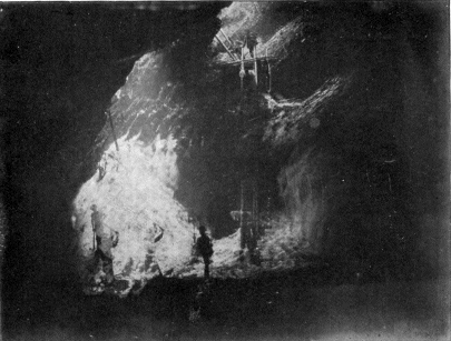
LA GLACIÈRE DE SAINT-GEORGES.
From a Photograph by E. Truand.
We walked up through woods, in about an hour and a half, to the Glacière de Saint-Georges, which lies at an altitude of 1287 meters in the midst of the forest. There are two holes close together. One of these descends vertically and is partly roofed over with logs on which is rigged a pulley. Émery, who was the entrepreneur of the glacière, which means that he attended to getting out the ice, told me that they pulled the ice up through this vertical hole, making a noose with a rope round each block.
The other and shallower opening ended in a rock floor, which was reached by a short ladder. To the right was an arch, under which the rock terminated as a floor and descended vertically, forming the wall of the cave. On this wall two ladders, spliced at the end into one long ladder, were placed in a nearly vertical position. I tied the end of my rope round my waist, and got a workman, who had come to cut ice, to pay out the rope to me, while I went down.
The cave is rather long and narrow, perhaps twenty-five meters by twelve meters, and the limestone roof forms an arched descending curve overhead. I could not see any limestone stalactites; neither were there any ice stalactites or stalagmites in the cave, but a good part of the wall, against which the long ladder was placed, was covered by an ice curtain. It was thin and had evidently been damaged by the ice cutters or I think it would have covered the entire lower portion of the wall.
The base of the long ladder rested on an ice floor which filled the bottom of the cave, and which would probably have been level if it had not been cut out here and there in places, leaving many holes. A good many broken ice fragments lay on the floor and in some of the holes were pools of water. Some of the floor ice was exceedingly prismatic in character, and I was able to flake it off or break it easily with my hands into prisms.
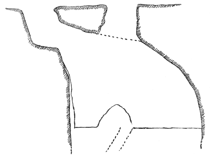
Fig. 7. Vertical Section of the Glacière de Saint-Georges.
Under the vertical shaft, which is at one end of the cave, was a mass of winter’s snow which had fallen through the opening. Under this snow was a deep hole, which I believe was the drain hole of the glacière before the ice floor was cut away to a level below its mouth. Into this hole I threw lumps of ice and heard them go bumping down for three or four seconds.
The atmosphere was not uncomfortable, although the temperature was about 7° C. The air did not feel damp, and seemed almost still, but standing on the ice floor nearly under the vertical hole, I found that the smoke from my cigar ascended rapidly, and it seemed as if there were a rising air current, which sucked up the smoke.
Saint-Georges is a fine cavern and well worth visiting. Émery said that the ice was not cut out for eight years preceding the summer of 1897, and that for several years it was not possible to go down at all, as there were no ladders, until he put in the two we utilized.[5] All the natives of Saint-Georges believed that the ice was a summer formation and that it was warm in the cave in winter.
THE GLACIÈRE DU PRÉ DE SAINT-LIVRES.
From the Glacière de Saint-Georges, Émery and I pushed on through the woods to the Pré de Saint-Livres. In several places we came on the tracks of deer, and my guide told me he had killed eleven roe during the last hunting season. He said also that an attempt is being made to introduce the red deer into the Jura, and that the experiment seemed to be meeting with success. We kept to the crest of the ridge along wood paths, and, as the day was fortunately cool and cloudy, we were able to walk fast and reached the Pré de Saint-Livres in two hours. At a spot called La Foiraudaz we met the workmen coming down with a cartload of ice, which they were taking to Bière. Some of this ice was extremely prismatic.
The Pré de Saint-Livres is a big mountain pasture or meadow, surrounded with hills covered with pine trees. In the middle of it is the Châlet de Saint-Livres, round which numerous cows and calves were congregated and where a small shepherd gave us some milk. The châlet is not one of the old picturesque Swiss châlets with great stones on the roof to keep it from being blown away by the wind, but a strongly built single storied stone structure, which looks extremely modern among the green hills.
The glacière lies close to the châlet, on the southern side of the meadows, just on the edge of the woods, and is surrounded with trees. It is at an altitude of 1362 meters and faces nearly due north. To prevent the cattle from falling in, it is enclosed with a stone wall, except in front, where there is a fence formed of an abattis of pine trees. The cave belongs to the pit variety, and the pit is a big one. As you stand at the top, you can look down to the end of the glacière. The rocks are vertical all round the pit, and in front there is a small rock shelf, one-third of the way down, which divides the rock wall into two long drops. Against each of these was a rickety ladder, so we fixed the end of my rope to the pine trees of the fence, and hung on to it while we climbed down. The base of the lower and longer ladder rested on a mass of snow. This was the beginning of a long snow slope which gradually turned to ice and filled the cave. The cave itself, measuring along the snow slope, is some forty meters long and some ten to fifteen meters wide, and is entirely lighted by daylight.
The snow and ice slope fell in a series of small waves, and the upper portion was rather dirty. On the right hand the workmen had fixed a rope as a handrail, and all the way down had cut a staircase in the ice, so that the descent was not difficult. Some of the ice was sloppy. The ice mass did not abut entirely against the end of the cave, but left an open space between the ice and the rock, some three or four meters wide and some four or five meters deep. Here the workmen had been getting their ice, and had cut into the ice mass for several meters, forming a little tunnel.
There were no ice cones nor stalactites, neither did I see any limestone stalactites. Much of the ice was prismatic; in fact, together with that at Saint-Georges, it was the most strongly prismatic I have seen. I can perhaps best describe it, by saying that it was brittle in texture, as I could break up small lumps in my hands. There was more prismatic ice at Saint-Livres, however, than at Saint-Georges. The air in the cave was still and decidedly damp; and the temperature was several degrees above freezing point. The day, however, was almost windless, and I would not assert that movements of air, due to the wind, might not sometimes take place in the pit.
The Glacière du Pré de Saint-Livres is one of those caves which may be looked on as a transitional form between gorges containing ice and caves containing ice. The winter snow falls into the mouth of the pit, and is the chief foundation of the ice mass. It would be interesting to make a series of observations in this cave to see whether there was anything like glacier motion. Émery, of his own accord, expressed the opinion that much of the ice here was due to the winter snows; in fact, he thought that it was all due to it, and that it gradually descended into the cave and turned, little by little, into ice. He told me that some years ago a cow was found by the workmen, frozen into the ice, at a depth of four meters; the flesh was perfectly preserved, and was eaten. I asked him if he had ever seen insects in either cave, and he said he had not.
From the glacière we walked back to the village of Saint-Georges. On asking my guide how much I owed him, he said he received four francs for a journée, so I gave him six francs, and we parted the best of friends.
GLACIER ICE CAVE IN THE FEE GLACIER.
During a rather protracted stay at Saas-Fee in Switzerland, I visited the glacier ice cave of the Fee Glacier on the 15th and 16th of August, 1897, both cool and rainy days. It is about half an hour’s walk from the hotel to the ice cave, which is in the snout of the Fee glacier, below the Eggfluh. A considerable stream issued from the cave. On nearing the opening, a strong cold air current poured out above the stream. At the front edge of the ice, the height of the ice roof in the centre was perhaps twelve meters and the width fifteen meters. Around the edge, the roof formed an almost perfect curve. The ice walls contracted in a regular manner within, and the cave became narrower and lower, and suggested an enormous funnel cut in half, into which you looked from the larger end. The cave also grew gradually darker, and the darkness prevented seeing further than to a depth of some fifteen meters. In the ice walls, just inside the entrance, were several crevasses, of the ordinary blue-green color. They followed nearly the same curve as the roof, but did not go through to the outside. There were no icicles. The ice was faintly stratified in places, and at the outer edge was brittle. It did not break into the long narrow prisms of the ice at Saint-Georges and the Pré de Saint-Livres, but rather into small lumps with facets, of all sorts of shapes. It was evidently unsafe to penetrate under the ice roof, for while I stood in front of the cave, a large lump broke off from the roof and fell with a clatter among a lot of other ice fragments already on the moraine floor. In two places there was a steady rain of drops from the roof, showing that the ice was melting.
This is perhaps the glacier cave in Switzerland which is easiest to visit, and my inspection intensified my belief in what I consider the correct explanation of some of the phenomena in glacières. The suggestion was that as soon as the temperature gets above freezing point in a glacier ice cave, the only process is that of destruction of the ice, which seems to be also the case with glacières.
LA GRAND CAVE DE MONTARQUIS.
My brother and I left Cluses, in Savoie, a railroad station on the line between Geneva and Chamonix, at two o’clock on the afternoon of the 22d of August, 1897, and drove up in two hours and a half to Pralong du Reposoir, a distance of eleven kilometers. The road is a route nationale, fine and broad, with parapets in many places. After passing Scionzier, it mounts gradually, passing through a tremendous wild gorge, cut by the waters and heavily clad with firs. We reached Pralong at four-thirty, and stopped at a primitive inn, still in process of construction, and tenanted only by blue-bloused peasants, who, as it was Sunday night, sat up late, drinking and making a heathenish noise they mistook for singing. I talked to some of these men, and they all insisted that there was no ice at the Grand Cave in winter, but that it came in summer. Plus il fait chaud, plus ça gêle, they said. One man explained the formation of the ice in an original way, and with an intelligence far above that of the average peasant. He considered that it was due to air currents, and thought that in winter the snow stopped up the holes in the rocks, through which the currents came; but that when the snow melted, the draughts could work, and that then they formed the ice.
The weather was abominable next morning, the clouds lying along and dripping into the valley; but the inn was so awful that we decided to try to reach the cave. We had a nice little blue-bloused peasant for a guide, Sylvain Jean Cotterlaz by name. We went first for about an hour on foot towards Le Grand Bornant on a fair road, to an alp called La Salle. This was surrounded by a herd of cows, some of whom seemed interested in our party. It now began to rain fiercely, and except for my brother’s perseverance, I should certainly have given in. A fair path led up steep grass slopes into the clouds covering the Mont Bargy. Each of us had his umbrella raised, and the ascent was slippery and uninspiring. An hour took us to two deserted huts, the Alpe Montarquis, and half an hour beyond, we came to the caves; by which time we were thoroughly soaked.
The caves are on Mont Bargy, at the base of a limestone precipice, which, I think, faces nearly north. There are three caves close together. The lowest, or Petite Cave de Montarquis, Cotterlaz said is also called La Cave des Faux-Monayeurs; as according to a, probably untrue, tradition, it was once used by counterfeiters. Above this is a small rock pocket, accessible down an easy slope. We went in and found that there was no ice and indeed scarcely any water in it.
The Grand—not Grande—Cave is a little higher up, and as we came to it, several sheep, which had taken refuge in the mouth from the storm, hastily skipped away, evidently distrusting our intentions. The altitude of the cave is said to be 2078 meters. The entrance must face about north east; it is elliptical in shape, about fifteen meters wide, and six meters high, and is badly sheltered against the wind. The cave is of moderate size, about sixty meters in length and forty-five meters in width, and the average height of the roof is not over four or five meters. A gentle slope leads downwards. Many blocks of rock in the front part had bits of moss growing on them, and some of the mud there was of a dull purple color, as if some dark madder was mixed with it. There was a red streak in the right hand wall, probably caused by iron. I observed no limestone stalactites nor stalagmites in the cave, the main body of which was well lighted throughout by daylight.
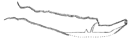
Fig. 8. Vertical Section of Grand Cave de Montarquis.
The ice was in the shape of a nearly level floor, about twelve meters long and eight meters wide: the shape was irregular, and the ice so smooth that it was hard to stand up. The rocks in the rear overhung the ice floor at one spot; and here, there streamed from a fissure to the ice floor an ice column, some three meters high, whose base was fully two meters distant from the rock wall. Near this column was a tiny ice cone, which evidently had been bigger. Cotterlaz seemed impressed with the fact that there was only one column in the cave, as he said that in June, there would have been many columns and a larger and deeper ice floor. The ice was sloppy in places, with several small hollows cut by the drip and containing water. In one place there was a tiny runnel filled with water, but there was no current. There was a good deal of drip all through the cave, and in fact in one or two places we might have kept on holding up our umbrellas with advantage. I hacked at several pieces of ice, but none of it was prismatic.
At the rear of the cave, the ice ran, in a tongue, up the entrance of an ascending fissure in the rocks. My brother cut here six or seven steps in the ice; and he found them difficult to make, as the ice was hard and thin, and not in a melting state. Above the ice tongue we clambered up the rocks of the fissure some four or five meters further, finding there some lumps of ice which were not melting. At this spot we were almost in darkness. A lighted match burned steadily, so that there was evidently not much draught, but the smoke gradually descended, showing a slight downward current. This was the coldest, as well as the furthest point of the cave we could reach, and we there heard a tiny waterfall trickling within the fissure, although we could not see it.
By this time we were all chilled to the bone, so, abandoning the idea of entering the Petite Cave, we retreated down the sopping wet, slippery grass slopes to Pralong, and then immediately walked all the way to Cluses to avoid taking cold. The Grand Cave was the most fatiguing trip I ever made after glacières, but the circumstances were rather unusual.
THE FREEZING WELL OF OWEGO.
On Thursday, June 23d, 1898, I went to Owego, in Tioga County, New York. Inquiries at the Lehigh Valley railroad station and at the chief hotel failed to elicit any information about a freezing well; and in fact, I soon found that the existence of such a thing was a blank to the rising generation. So I called on an old resident of Owego, who told me that he knew of the well in question and that it was filled up with stones many years ago; but that he remembered that, when he was a boy, it used to freeze, and that it was spoken of as the deep well or freezing well. I then walked up to the site of the well, which is about one and a half kilometers to the northwest from the centre of Owego and about one kilometer from the Susquehanna River. It is directly in the middle of the highway, and nothing is now visible but a heap of stones.
Near by was the house of a Mr. Preston, who told me he was born in 1816, and had lived all his life at this spot. He said that the well was about twenty-eight meters deep, and that it went first through a layer of sand and then through a layer of gravel. He had more than once been down the well and had seen the sides covered with ice. A bucket sent down for water would sometimes come up with ice on the sides. Whether the water at the bottom ever froze, no one knew, for the ice caked and filled up the bore at about two-thirds of the way down and became so thick, that as Mr. Preston put it, “it was just like hammering on an anvil to try to break it.” He also stated that another well was dug about one hundred meters further down the road, and that originally this sometimes had a little ice on the sides. Of late years however, it was covered over with a wooden top and since then no ice was known to form. I could obtain no information about any other wells in the neighborhood ever showing similar peculiarities.
THE ICY GLEN, NEAR STOCKBRIDGE.
The Icy Glen is situated on Bear Mountain, about one kilometer from Stockbridge, Massachusetts. It is in the midst of fine woods and there are many big trees in it. The bottom of the glen is full of rocks and boulders, among which there is a rough path. I was told that ice remained over there much longer than anywhere else in the neighborhood, sometimes as late as May. On the 3d of July, 1898, I not only found no traces of ice or snow, but the temperatures under the boulders showed nothing abnormal. To make up for this, however, there were legions of mosquitoes.
FREEZING MARBLE CAVE, NEAR MANCHESTER.
Near Manchester, Vermont, there is a little cave,[6] which is noteworthy, in that it is in a marble formation. It is known as Skinner’s Cave, because it was owned for many years by Mr. Mark Skinner. It lies in Skinner’s Hollow, some five or six kilometers from the centre of Manchester, at the base of the eastern slope of Mount Equinox, of the Taghconic Range of the Green Mountains.
The cave is on the property of Mr. N. M. Canfield, who, on learning the object of my visit, on the 5th of July, 1898, with true native American courtesy, walked up to it with me. The last two kilometers were over a rough logging road, which towards the end was steep and covered with many broken logs. I could not have found the cave alone, as it was so surrounded with bushes, that the entrance was invisible until we actually reached it. It is in a gorge of Mount Equinox, in the midst of a beautiful forest, which effectually cuts off any wind. The cave faces nearly north and can scarcely ever, if indeed at any time, be reached by the rays of the sun. The moment we got into the entrance, we found the chilly, damp, summer atmosphere of true glacière caves. The rocks were brown and mossy on the outside, but Mr. Canfield called my attention to the fact that they were marble, and on his knocking off a small piece, a section of pure white marble was exposed. In no other instance have I heard of a marble cave in connection with ice. There were scarcely any cracks or crevices in the rock.
The cave goes down with a steep slope from the entrance, much in the shape of a tunnel, for some ten meters. The slope was covered with slippery mud and decayed leaves, and at the bottom expanded into a little chamber, in which lay a mass of wet, compact snow, some two by three meters. It was evident that the snow was simply drifted in during the winter, and was in too large a mass and too well protected to melt easily, and there could be no question but that this place was purely a refrigerator. The air was tranquil throughout and there were no draughts. On the same day, a good breeze was blowing in the Manchester Valley.
THE FREEZING WELL OF BRANDON.
The Freezing Well of Brandon is situated on the western or southwestern outskirts of the village of Brandon, Vermont, not far from the railroad station. I visited it on the 7th of July, 1898. The well was protected by a wooden cover. On raising this, a faint stream of cool air seemed to issue forth; but this was probably only imagination. The sides, as far down as one could see, were built in with rather large blocks of stone without cement. At the bottom water was visible and there were no signs of ice. We drew up some water in a bucket, and although it was cool there was nothing icy about it. I twice lowered a thermometer nearly to the water and each time after ten minutes it registered only 13° C. There was certainly nothing abnormal in this temperature, in fact it was strictly normal and my thermometer showed conclusively by its actions that it could not have been near any ice mass. The people at the house, however, assured me that a month before there was ice in the well.
Afterwards I called on Mr. C. O. Luce, the owner of the well. He stated that it was eleven and a half meters deep to the bottom, that it was dug in 1858, and that the ground through which it goes was found frozen at a depth of about four and a half meters. Here there is a stratum of gravel and this is where the freezing occurs. Mr. Luce thought that the water was under the ice, that is, that the water came up from the bottom. He said also that the well usually froze solid in winter; but, that as this winter was an open one, there was less ice this year than usual. He thought that there was less ice anyway now than in former years, partly because of the cover which was put over the well, and which keeps out some of the cold; and partly because a neighboring gravel hillock, called the Hogback, was a good deal cut away, and this in some way affects the supply of cold in the gravel. He added that the sandy soil round Brandon does not as a rule freeze to a greater depth than two meters each winter. The house built beside the well was said to be comfortable in winter.
There seems no doubt that this is another refrigerator. The cold water of the winter snows percolates into the gravel mass and refreezes, and, owing to the bad conductive quality of the material, the gravel remains frozen later than the soil elsewhere in the neighborhood. The fact that the well went through a frozen gravel stratum when dug, proves that it is not alone the air that sinks into the well itself, which makes the ice. The fact that the well freezes on the whole less than formerly, apparently partly owing to the digging up of some of the gravel close by, goes to prove the same thing. The fact that the well generally freezes solid every winter, shows that although some of the gravel mass possibly remains frozen all the time, much of the ice is renewed each year. This is especially important as proving that the ice found in gravel deposits is due to the cold of winter and not to a glacial period, although, of course, no one could say for how long a time the ice was forming and melting; and this process might date back to the time of the formation of the gravel mass.
I could learn nothing of any similar place near Brandon, except that Mr. Luce said that in an old abandoned silver mine in the neighborhood, he had once seen ice during hot weather.
FREEZING TALUS ON LOWER AUSABLE POND.
On the eastern side of Lower Ausable Pond, Essex County, New York, at the foot of Mount Sébille or Colvin, there is a talus of great Laurentian boulders, which fell from the mountain and lie piled up on the edge of the lake. Among these boulders, at a distance of about five hundred meters from the southern end of the lake, there are spaces, several of which might be called caves, although they are really hollows between the boulders. On the 12th of July, 1898, I visited this spot with Mr. Edward I. H. Howell of Philadelphia. From several of the rock cracks we found a draught of air flowing strongly out, as tested by the smoke of a cigar. The air was distinctly icy and there could be no question that there was a considerable quantity of ice among the rocks to produce the temperature.
In three places we found masses of ice. One of these hollows was small, and the other two were much larger. One of the latter was almost round in shape, and perhaps three meters in diameter; with a little snow near the mouth and with plenty of ice at the bottom. The other was a long descending crack between two boulders which joined overhead, and with the bottom filled by a long, narrow slope of ice, perhaps seventy-five centimeters in width and six meters in length, set at an angle of about thirty-five degrees. The ice was hard and non-prismatic.
The cold air affects a large area of land around the boulders. Mr. Howell called my attention to the flowers of the bunch-berry, which he said were at least two weeks behind those on the surrounding mountains. The same was true of oxalis, a pretty white flower, of which we found several beds in full bloom.
Mr. Howell went to this talus, on the 4th of July previous, with Mr. Niles, President of the Appalachian Mountain Club, on which occasion they found plenty of snow near the entrance of the larger hollow. Mr. Howell, indeed, has repeatedly visited this place, and always found ice, which must, therefore, be looked on as perennial. At all times also he has felt cold draughts flowing out; sometimes they were so strong as to lower the temperature over the lake to a distance of thirty meters or more: on hot days he has seen occasionally a misty cloud form on the lake in front of the boulders. Mr. Howell considers that the draughts so affect the surrounding air, that an artificial climate is produced, and it is owing to this that spring flowers bloom late in July and sometimes in August. Another fact well known to him, is that in hot weather, the spot in front of the boulders is the best in the whole lake to catch trout, as they always congregate in the coldest water. The Adirondack guides use these ice retaining hollows, which they call ice-caves, as refrigerators for their provisions and game in hot weather: they say that the ice is formed in winter and remains over during the summer, as it is so well sheltered.
FREEZING TALUS OF THE GIANT OF THE VALLEY.
On the indications of Mr. Otis, chief guide of the Adirondack Reserve, I explored with Mr. C. Lamb, a guide from Keene Valley, the southern base of the Giant of the Valley Mountain, Essex County, New York, on the 14th of July, 1898. A road runs from Keene Heights to Port Henry, through the gap between the south base of the Giant of the Valley and the north base of Round Mountain, and passes close to a small lake called Chapel Pond. Some three hundred meters west of this lake, we left the road and struck north, across the brook, into the thick, mossy woods. After perhaps one hundred meters, we came to a talus of great boulders of Laurentian rock, with the cliffs of the Giant, whence the boulders had fallen, rising steeply above. We found ice under several of them, although never in any quantity. The thermometer, after an exposure of fifteen minutes in one of these little hollows, registered 6° C., although not more than one meter from where the sunshine fell on the moss. In the shade of a tree one meter distant from the same hollow it registered 26° C.; a difference of 20° C. at a distance of only two meters.
Perhaps one kilometer east of Chapel Pond, there is a place, where the bases of the mountains come much nearer together, which bears the name of “The Narrows.” Here we crossed the brook again, and, after some fifteen or twenty meters of scrambling through rough woods, reached once more the talus of the Giant, composed of tremendous boulders. Among these we found ice in many places and this time in large quantities. Within one boulder cave we found an ice slab some four meters in length, by two meters in width, and one meter in thickness. This was pure, hard and non-prismatic ice, and was evidently not formed of compressed snow: in fact snow could not have drifted in under the boulder. We broke off a large piece of ice and took it back to Saint Hubert’s Inn, and it melted rather slowly. From the mouth of this cave an icy draught issued, and, as it struck the warmer air outside, a slight mist was formed. Mr. Lamb said that from the road itself he had sometimes seen mist rising from this talus. Further explorations of the talus of the Giant would probably reveal ice in many other places than those we examined.[7]
Mr. Lamb told me of two other places in the Adirondacks, where he found ice in similar boulder formations. One was in the talus of Mount Wallface in Indian Pass, between Mounts Wallface and McIntyre. The other was in the talus of Mount McIntyre in Avalanche Pass, between Mounts McIntyre and Colden. At the latter place, he found it near the trail going round the lake in the pass.
THE ICE GULCH, RANDOLPH.
The Randolph Ice Gulch is situated in Randolph Township, New Hampshire, about eight kilometers from Randolph Station, on the Boston and Maine Railroad.[8] I visited it on August 11th, 1898. At the Mount Crescent House, I found a guide in the person of Mr. Charles E. Lowe, Jr. The excursion took us about six hours. The trail was a rough bush path, cut by the Appalachian Mountain Club, and which had not been cleaned out that year. It was a cloudy but hot day and this, combined with the badness of the road, made the walk fatiguing.
The Gulch lies between Crescent and Black Mountains. The altitude of the upper end of the Gulch is something over eight hundred meters, that of the lower end about six hundred meters. It is some fifteen hundred meters long, and averages perhaps one hundred meters in width at the top, and only a few meters at the bottom. The depth may be about seventy-five meters and the sides are steep, in some places sheer. The bottom is a mass of broken, fallen rocks, with a good many trees growing among them. There are several steps, so to speak, in the Gulch, which are called chambers, although the term seems rather meaningless. Promenading through the bottom of the Gulch was fraught with difficulty, because the rocks were placed in most unsuitable positions for human progression, and my hands were certainly as useful to me as my feet in preserving equilibrium. We found ice in one or two places, but not in any great quantity. In one spot it was overlaid by water. My guide said that there was less ice than the year before. A large piece which we broke off, and which furnished us with a cooling morsel of frozen fluid, was full of air bubbles. It was not prismatic ice, and was certainly unusual in formation. It crunched up under the teeth and, although it did not look like solidified snow, yet, judging from its position among the boulders, it was doubtless formed from the melting and refreezing of snow.[9] My guide said he had heard that fresh ice began to form sometimes in September. The Gulch is well protected against wind, and I detected no draughts among the rocks. Except in the immediate vicinity of the ice, the temperature was not abnormally low.
On returning to the Mount Crescent House, I had a talk with Mr. Charles E. Lowe, Sr., who told me that Alpine plants, like those which grow on Mount Washington and Mount Adams, are found in the Gulch; but that they do not exist on the neighboring Black and Crescent Mountains. He said also that ice was present in more than one place in King’s Ravine, and that it was always there.
FREEZING BOULDER TALUS AT RUMNEY.
About three kilometers south of Rumney, New Hampshire, there is a hill called Bald Mountain, which, about three hundred meters west of the carriage road from Rumney to Plymouth, descends as a big cliff, with an exposure facing nearly southeast. At the base of this cliff, there is a talus[10] which I visited on the 27th of August, 1898, with the Sheriff of Rumney, Mr. Learned. He said he had found plenty of ice there on the 18th of August, 1897, but he doubted whether there would be any left this year, on account of the hot weather. Effectively a careful hunt failed to reveal any ice, although the talus was just the kind of place where it might have been expected, as the boulders were piled one over the other and in one or two places there were considerable hollows. The temperatures were normal, and there were no draughts. The talus is exposed to the sun, and only moderately sheltered against wind by a scrub forest. But there can be no doubt, that ice lingers there long after it has disappeared from every other spot in the neighborhood, and it seems as if our not finding any, is another proof that it is the heat of summer which melts it away.
ICE FORMATIONS AND WINDHOLES AT WATERTOWN.
At Watertown, New York, on the south side of the Black River, in the town itself, are some natural cracks or crevices in the limestone rocks. They are only a short distance from the New York Central Railroad station. The cracks enter the northern side of the railroad embankment, pass under the railroad tracks, and extend some distance back. In front of them are four cellars, used for storing beer kegs. The lessor, Mr. Ehrlicher, obligingly had the cellars opened for me, on the 12th of September, 1898. There was neither ice nor draughts in the cellars, and the temperature was normal. Mr. Ehrlicher said that in the spring there was ice in the cracks, but that it had all melted away as the result of the hot summer.
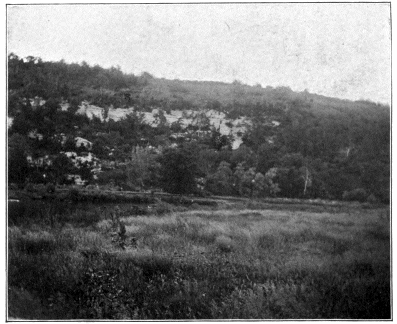
THE BLUFF AT DECORAH.
From a Photograph by Mr. A. F. Kovarik.
About four kilometers west of Watertown, on the south bank of the Black River, is the picnic ground of Glen Park, which is reached by trolley. The manager of the restaurant walked around the park with me. In one spot is a hollow or glen at the base of a small, much cracked limestone cliff, which has a northern exposure. The manager said that snow and ice usually lies in this place until June, not only among the broken rocks, but even in the open. Sometimes ice remains among the boulders all summer, but only near the front of the boulders, and by pushing in, one soon gets beyond it: we found none, a fact showing once more the effect of the unusually warm summer. On hot days, draughts issue from between the boulders, but as the day was cool, we did not notice any. The spot is well sheltered against the wind by a number of trees; and the shape of the hollow reminded me of the glen in front of the Eishöhle bei Roth.
Not one hundred meters from this hollow, is a little limestone cave, closed by a wooden door, which excludes any cold air in winter. The cave is lighted by electric lights, and is a narrow, crooked, descending fissure, a ganghöhle, where the marks of water action are plainly visible. At the bottom a little stream, evidently the active agent in forming the cave, ran through the fissured limestone. In the stream a large toad or frog was swimming about. There was nothing icy about the cave or the water, and the temperature was normal. Ice was never known to form in the cave. These two places, so close together, are an interesting confirmation that it is only where the outside cold can get in, that we find subterranean ice.
THE FREEZING CAVE AND FREEZING WELLS OF DECORAH.
Near Decorah, Iowa, is a freezing cavern, which is more frequently referred to in cave literature than is generally the case. I visited it on Friday, September the 30th, 1898, with an old English resident of Decorah, Mr. W. D. Selby-Hill. The cave is situated about one kilometer to the northward of Decorah, on the north bank of the Upper Iowa River, at the base of a bluff. It is some thirty to forty meters above the stream, and faces southward. It looks like a fault or fissure in the rocks, with the sides meeting a few meters overhead. It is a true cave, but probably in an early stage of formation, for there are no apparent traces of water action, nor any stalagmites nor stalactites. The absence of the latter may, however, be due to the fact that it is a periodic glacière. The rock is a white limestone, rich in fossils. The cave is some two to three meters in width and is rather winding, with a short arm or pocket branching out on the west side. The main cave runs back some thirty meters from the entrance. In one place it is necessary to stoop, to get past some overhanging rock slabs. By candle light, we went to the rear of the cave, and found it warm, dry, and free from ice. There were no draughts, possibly because the day was cool.
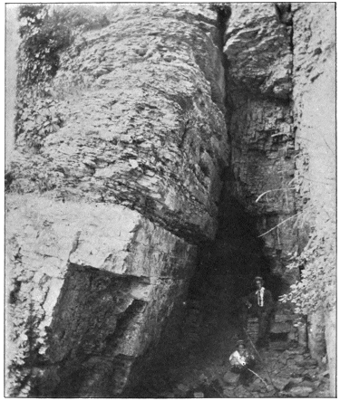
ENTRANCE OF THE CAVE OF DECORAH.
From a Photograph by Mr. A. F. Kovarik.
I looked in vain for tubular fissures, or indeed any fissures, through which water might freeze by pressure in its descent, as the believers in the capillary theory say it does. Nothing of the kind existed, and I wrote in my note-book: “Writing on the very spot about which this theory was started, I feel justified in asserting that the theory amounts to absolutely nothing and is entirely incorrect.”
Mr. Hill told me that there were two wells in the southern portion of Decorah Township, where ice was found in summer. I visited them both, but found no ice, and the temperatures normal. Mr. Hill said that one of the wells was dug about thirty years ago, and that the workman told him that the ground which he went through was frozen; and that at one place he struck an opening, from which came so strong a current of icy air, that it was hard to keep at work.
I talked to several persons afterwards. Inter alia, they told me that the bluff was a great place for rattlesnakes, sometimes big ones. They admitted also generally that they were puzzled about the formation of ice in the cave. Some claimed that the ice formed in summer—the old story once more. I met, however, Mr. Alois F. Kovarik of the Decorah Institute, who had made a series of regular observations for over a year and found that the ice begins to form about the end of March and beginning of April, and is at its maximum towards the beginning of June. Mr. Kovarik also told me, that he had found ice in one of the wells in the beginning of August.
This was an especially satisfactory trip to me, for it did away, once for all, with any possible belief that there was any basis of fact for the capillary theory. It also seems to me important to find that the ice of these freezing wells melts in summer. For it shows that their ice is due to the same causes as those which form the ice in the cave, and is another proof against the validity of the glacial period theory.
FREEZING ROCK TALUS ON SPRUCE CREEK.
On Spruce Creek, Huntingdon County, Pennsylvania, about four kilometers north of the Pennsylvania Railroad depot, is an ice bearing talus, known locally as the Ice Holes or Ice Caves. I visited this spot, on October the 5th, 1898, with Mr. Benner, of Spruce Creek. We walked up the pretty valley along the old Pittsburgh turnpike, at one place finding some papaw trees, whose fruit had a horrible sickening taste; then we crossed Spruce Creek by a footbridge and followed the other bank back for some five hundred meters, until we were nearly opposite the old Colerain Forge, which is located in a piece of land called by the curious name of Africa. About half way from the bridge we smelt a strange odor, which my companion thought came from a copperhead or rattlesnake: we did not investigate.
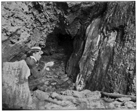
LOCUS GLACIALIS—CAVE OF DECORAH.
From a Photograph by Mr. A. F. Kovarik.
The freezing talus is situated at the foot of Tussey Mountain: it is big, and is composed of small sandstone (?) rock débris. The talus is at least thirty meters high and one hundred and twenty meters long. As I stood at the bottom, I was reminded strongly of the talus at the Dornburg. At the base were a number of small pits, evidently dug by man. From the interstices between the rocks, icy cold draughts issued in some places, and there was no doubt that there was plenty of ice beneath the stones. In one place we thought we could see ice, and I poked at the white substance with my stick, but I am not positive that it was ice. All over the talus, the temperature was strikingly colder than a few meters away, and in the pits we could see our breaths distinctly. Although I am not much of a botanist, yet it seemed to me that the flora immediately near the talus was somewhat different in character from that of the surrounding country.
Mr. Benner told me that he saw, three or four weeks before, plenty of ice in the pits; that they were made by farmers who formerly came to this spot to get ice; and that parties occasionally picnic here in the summer and make ice cream. He stated also that he saw, some years ago, a small cave or hole containing ice near Mapleton, Pennsylvania, but that it was destroyed by quarrying the rock away.
FREEZING GORGE NEAR ELLENVILLE.
On Sunday, October the 9th, 1898, with a young man from Ellenville, I visited the well known Ellenville Gorge, in the Shawangunk Range, Ulster County, New York. We left the hotel at eight-forty A. M. and reached the gorge, known locally as the Ice Cave, at ten-five A. M. It is about four kilometers northeast from Ellenville. The path rises steadily uphill and is of the roughest description; it is covered with loose stones, and looks as if it might become the bed of a mountain brook in wet weather.
I call this place a gorge, instead of a cave, because it is uncovered at the top, but probably originally it was covered. It is shaped like a pit cave minus a roof, and it reminded me of the Friedrichsteiner Eishöhle, and the Glacières de Saint-Georges and du Pré de Saint-Livres. It is entered by a long slope from the western end, the gorge turning northward further back. I estimated its width, at the bottom at some five to seven meters, at the top at some three to four meters; its length at some thirty meters and the deepest point we reached, at some twenty meters below the surface. These are guesses, however. In one place, a great rock slab overhangs the gorge. At nearly the lowest point of the rock floor, there is a hole which extends perpendicularly downwards some five or ten meters more; this opening is partly blocked up with fallen masses of rock which would make a further descent perilous. The north end of the gorge is also filled up with a mass of great broken rocks; in fact, the whole place is out of repair, as the rocks are cracked and creviced on both sides to a great extent. The rock is friable and seems to be all breaking up, or rather down, and I think there is some danger from falling stones, although I did not see any fall. There is a good deal of moss on the sides of the gorge, and on some ledges small evergreens are growing. The gorge is sheltered thoroughly from winds by its formation and position, and somewhat by the scrub forest surrounding it. There are several long, deep crevices a few meters further up the mountain side, and I think one of them is an extension of the main gorge.
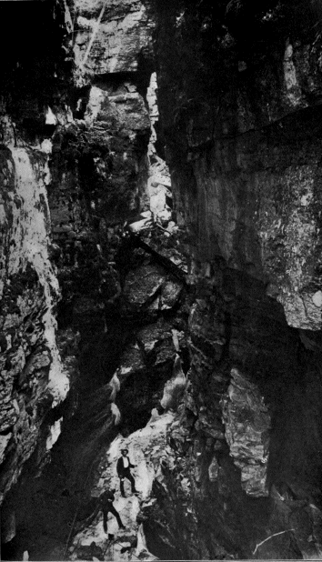
GORGE AT ELLENVILLE.
From a Photograph by Mr. Davis.
We found no ice. It generally lasts till about the beginning of September; and Professor Angelo Heilprin, and Miss Julia L. Lewis, of Philadelphia, have found plenty of it in July and August. But the ice had evidently now been gone for some time, for the temperature at the bottom of the gorge was about 11° C. at ten-thirty A. M. This was but little colder than the temperature v outside, which at ten-fifteen A. M. was 14° C.
On returning to Ellenville, I learnt that there was another somewhat similar smaller gorge, some eight kilometers away, at a place called Sam’s Point. This, however, is said to retain only snow, while in the Ellenville gorge much ice is sometimes formed, and icicles a couple of meters long are said to hang on the sides of the cliffs. The proprietor of the hotel told me he had heard of a cave which contained ice not far from Albany, at a place called Carlisle, on the Delaware and Hudson Railroad.
FREEZING CAVE AND WINDHOLES NEAR FARRANDSVILLE.
I arrived at Farrandsville, Clinton County, Pennsylvania, early on Tuesday morning, October the 11th, 1898, and found a boy, who worked in a brick mill, as guide to the caves.[11] After emptying a small, flat bottomed boat of the water of which it was half full, we rowed across the Susquehanna River; then we walked up the road, along the river bank, for a couple of hundred meters, and struck up the so-called path to the caves. Although the whole of the mountain side was at the disposal of the road maker, no better plan seems to have suggested itself than to make the track go straight up. This saved making zigzags, yet the result is that the path is steep, and as it is rocky and slippery, it is hard travelling without bootnails or alpenstock.
As we went up, I noticed, in one or two places, cold draughts issuing from crevices in the rocks. We soon came to a hollow under a rock, where there were a number of cracks and crevices: the boy spoke of it as the lower cave. It is some sixty meters above the Susquehanna River and cold draughts flowed from the cracks, although we saw no ice. The cave was about twenty meters higher up. One could crawl into it for a couple of meters, and all round it the rocks are somewhat creviced; in fact, I think there are a good many cracks in the entire hill. There was no ice in sight in this hole, but a strong, cold draught poured from it. After an exposure of fifteen minutes the thermometer registered 6° C.; while outside, in the shade, it stood at 15° C. This decidedly sub-normal temperature proved unmistakably, in my opinion, the presence of ice a little further than we could see in. Both holes face about north and are sheltered, by their position and by the sparse forest which covers the ridge, against all winds except those from the north.
I talked to the postmaster and the railroad agent at Farrandsville on my return, and they stated that there was no ice in the hole in winter, but that it formed about April and remained over until towards September, showing that the cave is a normal glacière on a small scale.
GLACIÈRES NEAR SUMMIT.
In the search for coal, the mountains of the Appalachian Chain between the little town of Summit, and the neighboring village of Coaldale, Carbon County, Pennsylvania, were mined and tunneled in every direction. Owing to the caving in of some of these mines, depressions formed in certain places along the ridge in the upper surface of the ground, and in two of these hollows natural refrigerators occur. These were brought to my notice by Mr. C. J. Nicholson of Philadelphia, and I visited them on May the 5th, 1899, in company with two coal miners of Summit.
Starting from Summit, we passed across some rough ground under which there was a mine on fire; and the miners showed me the tops of two pipes sticking out of the ground, from which issued a smoke or steam, too hot to hold the hand in more than a few seconds. Going beyond through brushwood, for a couple of hundred meters, we came to the first glacière, which was also the nearest to Summit. It faced almost due north and looked as if it was formerly the entrance to a mine. It was fairly big, and my companions assured me that, until within about a year, ice was always found in it. Recently, however, part, of the rock roof fell in, blocking up the entrance with a mass of débris and making it unsafe to venture in. Formerly parties of tourists constantly visited this place, after coming over the Switchback, but this is no longer done and there has been some talk of cleaning away the broken rocks and making the glacière accessible. The men also said that occasionally people living in the neighborhood had dug out the ice for their own use.
The other glacière was a short distance further, in the direction of Coaldale. It is in a pit, which may have been the mouth of a disused shaft or only a depression resulting from a cave-in. A scrubby forest, which surrounds the hollow, acts as a windbrake. A rather steep slope leads down into the pit, and at the end passes under the wall of rock of the opposite side for a short distance, forming a small cave, which faces almost due south and whose floor is choked up with broken rock fragments. At the bottom of the slope we found some snow, and among the boulders a good deal of snow-ice as well as several long icicles hanging from the rocks. All the ice and snow lay on the north side of the rocks, or underneath them, so that it was in shady places where the sun could not reach it. The temperature was not at all uncomfortable, although somewhat cool and damp.
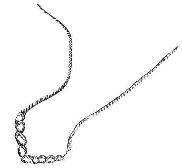
Fig. 9. Vertical Section of Pit near Summit.
There was nothing in either glacière, to show that the ice was formed from any other cause than the drifting in, and melting and refreezing of the winter’s snow; and my impression is that the ice in the second glacière could not last through the summer.
THE SNOW HOLE NEAR WILLIAMSTOWN.
The Snow Hole near Williamstown (Massachusetts) is situated near the northern end of the Petersburgh Mountain of the Taghconic Range; it is slightly below the watershed on the Williamstown side, at an altitude of about seven hundred meters. The Snow Hole is in the State of New York, near the boundary between New York and Massachusetts. It is a long two hours’ drive from Williamstown, the last four kilometers or so, over an exceedingly steep and rough road, which is, in fact, nothing but an old logging road, and the worst I ever drove over except the road to Démenyfálva.
I visited the Snow Hole with my brother on Friday, September the 29th, 1899. It is surrounded by a dense forest, mainly of recent growth, which thoroughly shelters it from all winds. In shape and appearance it resembles the Gorge at Ellenville, except that it is smaller: its location on the ridge is not unlike that of the Friedrichsteiner Eishöhle. It is a narrow crack—or cave minus a roof—about fifteen meters long, six to seven meters deep and from two to five meters wide. It faces nearly north, and the bottom is in perpetual shadow. From the northern end, a gentle slope leads to the rear. The slope was a good deal blocked up by a big tree with large branches, which had fallen directly into the fissure. There was some moss or greenish mould on the rocks in places, and at the rear end of the slope there were some fissures in the rocks, into which one might perhaps have crawled a little farther, which formed a tiny cave. There was also a similar incipient cave at the northern end. I could not detect any draughts issuing from these rock fissures, and the air throughout was still, although the wind was blowing hard on the ridge. The rocks were moist in places and the air damp, but there was neither snow nor ice and the temperatures were normal. The driver told me that he had found plenty of snow in the base of the gorge some years ago in July; and he said that he had always heard that snow was found in the Snow Hole all the year round. All the conditions of the place, the shape of the fissure, and its sheltered northern exposition, are favorable to the retention of ice and snow, and it is not surprising that they remain over every spring.
ICY GULF NEAR GREAT BARRINGTON.
The Icy Gulf or Icy Glen is some eight kilometers from Great Barrington, Massachusetts. I have not been in it, but was told in October, 1899, by the farmers living near by, that after snowy winters, ice remains over through July. It must be similar to the Icy Glen at Stockbridge.
THE ICE BED OF WALLINGFORD.
The Ice Bed of Wallingford is situated about three kilometers to the east of Wallingford, Vermont. A drive of half an hour, over the Mount Holly and Hearburrow roads, takes the visitor to the entrance of a rough wood path, which, at a distance of three or four hundred meters, leads to the Ice Bed. This is a huge talus, at the base of the White Rock Mountain, whose cliffs rise steeply overhead for some three or four hundred meters. The talus, which was doubtless formed by a great slide at some distant date, consists of granite boulders, some of which are big ones. The ice-bearing portion may be some thirty or forty meters high vertically. It lies in a sort of gully or rock basin, and at the top is about thirty meters broad, tapering to a point at the bottom. The talus faces southward, and during a good part of the day the sun shines full upon it. A thin forest fringes the sides and grows round the bottom, but this can afford but little protection from the winds, especially to those from the south.
I visited this place on the 5th of October, 1899. There was a distinct drop in temperature as we neared the base of the talus, and a cool air drew gently down over the rocks. I think slight draughts issued from some of the crevices; but of this I am not sure. The temperature was sub-normal, about 8°, but hardly low enough to prove the presence of ice, although we could see our breaths distinctly. We looked carefully under a number of the boulders, but neither ice nor snow was visible. I was assured that ice was abundant there in the past July and August, and I should think it had melted away only shortly before my visit. My impression is, that this is a periodic glacière.
CAVES NEAR WILLIAMSTOWN.
On the eastern slope of the Petersburgh Mountain of the Taghconic Range in Massachusetts, at a good deal lower altitude than the Williamstown Snow Hole and about southeast of it are some caverns, which are but little known. A five or six kilometer drive from Williamstown takes the visitor to the base of the mountain, whence a rather steep ascent of about a kilometer and a half brings him to the caves, which are in the midst of a dense, scrub forest.
The caves were first entered, and possibly discovered, by Mr. W. F. Williams, of Williamstown, when a boy. Since then, he has visited them many times and explored them a good deal. They do not appear to have any name as yet, and it would seem only fitting to christen them after their explorer: the Williams Caves.
There are several unimportant holes in the immediate neighborhood of the two main caves. The latter lie side by side. The rock formation is the same as that of the Snow Hole, a dark gray slate with a few veins of quartz, and they are due also evidently to the same geological causes. It would seem as though the mountain had tended to open or crack at these spots and fallen apart. This seems probable, because wherever there is a projection on one side of the cracks, there is a corresponding hollow in the opposite side. After this, water action has come, and erosion and corrosion have worn out and carried away earthy matter, and slowly deepened and widened the fissures. The remarkable point in connection with the main caves, however, is that one is a normal cave and the other a periodic glacière.
I went with Mr. Williams to these caves on the 6th of October, 1899, and partially explored the glacière. On the way up, just as we left the carriage road, a fine, three-year-old buck, in his winter coat, came bounding out of the forest; on seeing us he stopped, and after taking a good look, quietly trotted off into the bushes.
The glacière is rather peculiar in shape and may be described as two storied. A long slope, set at an angle of some forty degrees, and covered with mud and dead leaves, leads down into the crack, which is from one to three meters in width. The first half of the slope is open to the sky; the last half is covered by the rock roof, and is a real cave. In this the floor is horizontal, the place forming a little chamber in which the daylight has almost vanished. At the exact summit of the slope a big tree grew most conveniently; and we tied to this one end of a twenty-meter Austrian Alpine Club rope, and by holding fast to it, and kneeling or sitting down in the mud in two or three places, the descent was easy enough. It was rather difficult to scramble up the slope again, however.
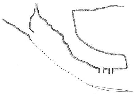
Fig. 10. Vertical Section of Freezing Cave near Williamstown.
In the floor of the little chamber there are two holes, and, stepping over these, we stood at the rear end, about eighteen meters distant from the beginning of the slope. My companion now set some birchbark on fire and dropped it into the innermost hole, and we laid down in turn, flat on the rock floor, and craned our necks through the hole. Mr. Williams thought he could see ice below us. I looked down after him and found that I was looking into a lower chamber whose sides were invisible. The floor was some three meters below vertically, and on this the birchbark was burning brightly. I think I saw some ice, but I could not be sure, as there was too much smoke to see distinctly. My companion offered to go down through the hole and get some ice; a proposition I promptly vetoed, as had anything gone wrong, I could not possibly have given him any assistance, as there was no extra rope. Mr. Williams told me that he went down several times before in July or August, and always found ice on the slanting floor. He said he did not know how far this lower chamber extended, nor the length of the ice floor. One thing which makes me hesitate to think that we saw ice was, that the temperature of the chamber where we were was not at all icy; but probably—I had forgotten my thermometer—nearly normal.
When we stood once more by the tree at the top of the slope, the mouth of another cave was visible about two meters below us. Mr. Williams said it had never looked more than a little crack before, and that the opening was much bigger than at his last visit. It was directly under the slope by which we descended and it vanished into darkness. Its direction led straight towards the lower chamber, and it almost surely leads to it. It seems thus that there are two hollows, one directly above the other; and that the lower one is a glacière, while the upper one is not. The cold air of winter would naturally sink into the lower chamber, and the spring thaws would furnish plenty of drip, so that this place seems to answer every requirement of a cave glacière.
But the most interesting fact about these caves is that, while the shallower one is a glacière, the bigger and deeper one is not. This is situated about ten meters north of the glacière and the direction of the entrance is about the same. Mr. Williams has found snow and ice in May in the entrance pit as far as the daylight goes, but none beyond. I am inclined to think that the explanation of this is the fact that the cave is a ganghöhle or tunnel cave. Mr. Williams described it as a narrow passage with chambers, and at least a hundred meters long, and fifty meters in depth below the surface. The cold air sinks in a certain distance, but as the passage is narrow and long, and too winding for any strong draughts, the cold air which enters is soon neutralized by the supply of warmer air within and by contact with the rocks. I cannot help thinking that it is by some such explanation that we must hope to solve the problem of why certain caves are glacières and others in the immediate neighborhood normal caves; and the caves near Williamstown are exceptional in presenting the problem so patently.