Front matter (continued 6)
Reading edition
It was their ascription to glacier action that first gave the parallel roads of Glen Roy an interest in my eyes; and in 1867, with a view to self-instruction, I made a solitary pilgrimage to the place, and explored pretty thoroughly the roads of the principal glen. I traced the highest road to the col dividing Glen Roy from Glen Spey, and, thanks to the civility of an Ordnance surveyor, I was enabled to inspect some of the roads with a theodolite, and to satisfy myself regarding the common level of the shelves at opposite sides of the valley. As stated by Pennant, the width of the roads amounts sometimes to more than twenty yards; but near the head of Glen Roy the highest road ceases to have any width, for it runs along the face of a rock, the effect of the lapping of the water on the more friable portions of the rock being perfectly distinct to this hour. My knowledge of the region was, however, far from complete, and nine years had dimmed the memory even of the portion which had been thoroughly examined. Hence my desire to see the roads once more before venturing to talk to you about them. The Easter holidays of 1876 were to be devoted to this purpose; but at the last moment a telegram from Roy Bridge informed me that the roads were snowed up. Finding books and memories poor substitutes for the flavour of facts, I resolved subsequently to make another effort to see the roads. Accordingly last Thursday fortnight, after lecturing here, I packed up, and started (not this time alone) for the North. Next day at noon my wife and I found ourselves at Dalwhinnie, whence a drive of some five-and-thirty miles brought us to the excellent hostelry of Mr. Macintosh, at the mouth of Glen Roy.
We might have found the hills covered with mist, which would have wholly defeated us; but Nature was good-natured, and we had two successful working days among the hills. Guided by the excellent ordnance map of the region, on the Saturday morning we went up the glen, and on reaching the stream called Allt Bhreac Achaidh faced the hills to the west. At the watershed between Glen Roy and Glen Fintaig we bore northwards, struck the ridge above Glen Gluoy, came in view of its road, which we persistently followed as long as it continued visible. It is a feature of all the roads that they vanish before reaching the cola over which fell the waters of the lakes which formed them. One reason doubtless is that at their upper ends the lakes were shallow, and incompetent on this account to raise wavelets of any strength to act upon the mountain drift. A second reason is that they were land-locked in the higher portions and protected from the south-westerly winds, the stillness of their waters causing them to produce but a feeble impression upon the mountain sides. From Glen Gluoy we passed down Glen Turrit to Glen Roy, and through it homewards, thus accomplishing two or three and twenty miles of rough and honest work.
Next day we thoroughly explored Glen Glaster, following its two roads as far as they were visible. We reached the col discovered by Mr. Milne-Home, which stands at the level of the middle road of Glen Roy. Thence we crossed southwards over the mountain Creag Dhubh, and examined the erratic blocks upon its sides, and the ridges and mounds of moraine matter which cumber the lower flanks of the mountain. The observations of Mr. Jamieson upon this region, including the mouth of Glen Trieg, are in the highest degree interesting. We entered Glen Spean, and continued a search begun on the evening of our arrival at Roy Bridge — the search, namely, for glacier polishings and markings. We did not find them copious, but they are indubitable.
One of the proofs most convenient for reference, is a great rounded rock by the roadside, 1,000 yards east of the milestone marked three-quarters of a mile from Roy Bridge. Farther east other cases occur, and they leave no doubt upon the mind that Glen Spean was at one time filled by a great glacier. To the disciplined eye the aspect of the mountains is perfectly conclusive on this point; and in no position can the observer more readily and thoroughly convince himself of this than at the head of Glen Glaster. The dominant hills here are all intensely glaciated.
But the great collecting ground of the glaciers which dammed the glens and produced the parallel roads, were the mountains south and west of Glen Spean. The monarch of these is Ben Nevis, 4,370 feet high. The position of Ben Nevis and his colleagues, in reference to the vapour-laden winds of the Atlantic, is a point of the first importance. It is exactly similar to that of Carrantual and the Macgillicuddy Reeks in the south-west of Ireland. These mountains are, and were, the first to encounter the south-western Atlantic winds, and the precipitation, even at present, in the neighbourhood of Killarney, is enormous. The winds, robbed of their vapour, and charged with the heat set free by its precipitation, pursue their direction obliquely across Ireland; and the effect of the drying process may be understood by comparing the rainfall at Cahirciveen with that at Portarlington. As found by Dr. Lloyd, the ratio is as 59 to 21 — fifty-nine inches annually at Cahirciveen to twenty-one at Portarlington. During the glacial epoch this vapour fell as snow, and the consequence was a system of glaciers which have left traces and evidences of the most impressive character in the region of the Killarney Lakes. I have referred in other places to the great glacier which, descending from the Reeks, moved through the Black Valley, took possession of the lake-basins, and left its traces on every rock and island emergent from the waters of the upper lake. They are all conspicuously glaciated. Not in Switzerland itself do we find clearer traces of ancient glacier action.
What the Macgillicuddy Reeks did in Ireland, Ben Nevis and the adjacent mountains did, and continue to do, in Scotland. We had an example of this on the morning we quitted Roy Bridge. From the bridge westward rain fell copiously, and the roads were wet; but the precipitation ceased near Loch Laggan, whence eastward the roads were dry. Measured by the gauge, the rainfall Fort William is 86 inches, while at Laggan it is only 46 inches annually. The difference between west and east is forcibly brought out by observations at the two ends of the Caledonian Canal. Fort William at the south-western end has, as just stated, 86 inches, while Culloden, at its north-eastern end, has only 24. To the researches of that able and accomplished meteorologist, Mr. Buchan, we are indebted for these and other data of the most interesting and valuable kind.
Adhering to the facts now presented to us, it is not difficult to restore in idea the process by which the glaciers of Lochaber were produced and the glens dammed by ice. When the cold of the glacial epoch began to invade the Scottish hills, the sun at the same time acting with sufficient power upon the tropical ocean, the vapours raised and drifted on to these 'northern mountains were more and more converted into snow. This slid down the slopes, and from every valley, strath, and corry, south of Glen Spean, glaciers were poured into that glen. The two great factors here brought into play are the nutrition of the glaciers by the frozen material above, and their consumption in the milder air below. For a period supply exceeded consumption, and the ice extended, filling Glen Spean to an ever-increasing height, and abutting against the mountains to the north of that glen. But why, it may be asked, should the valleys south of Glen Spean be receptacles of ice at a time when those north of it were receptacles of water? The answer is to be found in the position and the greater elevation of the mountains south of Glen Spean. They first received the loads of moisture carried by the Atlantic winds, and not until they had been in part dried, and also warmed by the liberation of their latent heat, did these winds touch the hills north of the Glen.
An instructive observation bearing upon this point is here to be noted. Had our visit been in the winter we should have found all the mountains covered; had it been in the summer we should have found the snow all gone. But happily it was at a season when the aspect of the mountains north and south of Glen Spean exhibited their relative powers as snow collectors. Scanning the former hills from many points of view, we were hardly able to detect a fleck of snow, while heavy swaths and patches loaded the latter. Were the glacial epoch to return, the relation indicated by this observation would cause Glen Spean to be filled with glaciers from the south, while the hills and valleys on the north, visited by warmer and drier winds, would remain comparatively free from ice. This flow from the south would be reinforced from the west, and as long as the supply was in excess of the consumption the glaciers would extend, the dams which closed the glens increasing in height. By-and-by supply and consumption becoming approximately equal, the height of the glacier barriers would remain constant. Then, as milder weather set in, consumption would be in excess, a lowering of the barriers and a retreat of the ice being the consequence. But for a long time the conflict between supply and consumption would continue, retarding indefinitely the disappearance of the barriers, and keeping the imprisoned lakes in the northern glens. But however slow its retreat, the ice in the long run would be forced to yield. The dam at the mouth of Glen Roy, which probably entered the glen sufficiently far to block up Glen Glaster, would gradually retreat. Glen Glaster and its col being opened, the subsidence of the lake eighty feet, from the level of the highest to that of the second parallel road, would follow as a consequence. I think this the most probable course of things, but it is also possible that Glen Glaster may have been blocked by a glacier from Glen Trieg. The ice dam continuing to retreat, at length permitted Glen Roy to connect itself with upper Glen Spean. A continuous lake then filled both glens, the level of which, as already explained, was determined by the col at Makul, above the head of Loch Laggan. The last to yield was the portion of the glacier which derived nutrition from Ben Nevis, and probably also from the mountains north and south of Loch Arkaig. But it at length yielded, and the waters in the glens resumed the courses which they pursue to-day.
For the removal of the ice barriers no cataclysm is to be invoked; the gradual melting of the dam would produce the entire series of phenomena. In sinking from col to col the water would flow over a gradually melting barrier, the surface of the imprisoned lake not remaining sufficiently long at any particular level to produce a shelf comparable to the parallel roads. By temporary halts in the process of melting due to atmospheric conditions or to the character of the dam itself, or through local softness in the drift, small pseudo-terraces would be formed, which, to the perplexity of some observers, are seen upon the flanks of the glens to-day.
In presence then of the fact that the barriers which stopped these glens to a height, it may be, of 1,500 feet above the bottom of Glen Spean, have dissolved and left not a wreck behind; in presence of the fact, insisted on by Professor Geikie, that barriers of detritus would undoubtedly have been able to maintain themselves had they ever been there; in presence of the fact that great glaciers once most certainly filled these valleys — that the whole region, as proved by Mr. Jamieson, is filled with the traces of their action; the theory which ascribes the parallel roads to lakes dammed by barriers of ice has, in my opinion, a degree of probability on its side which amounts to a practical demonstration of its truth.
Into the details of the terrace formation I do not enter. Mr. Darwin and Mr. Jamieson on the one side, and Sir John Lubbock on the other, deal with true causes. The terraces, no doubt, are due in part to the descending drift arrested by the water, and in part to the fretting of the wavelets, and the rearrangement of the stirred detritus, along the belts of contact of lake and bill. The descent of matter must have been frequent when the drift was unbound by the rootlets which hold it together now. In some cases, it may be remarked, the visibility of the roads is materially augmented by differences of vegetation. The grass upon the terraces is not always of the same character as that above and below them, while on heather-covered hills the absence of the dark shrub from the roads greatly enhances their conspicuousness.
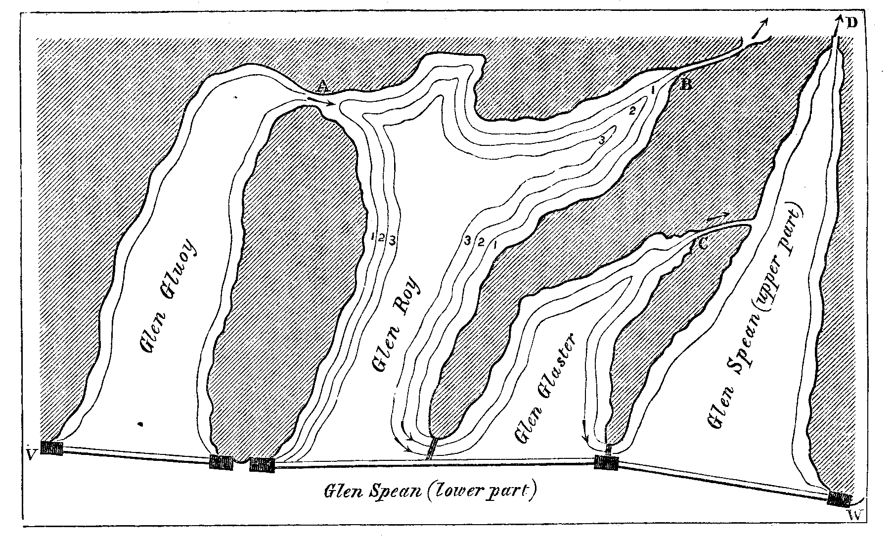
The annexed sketch of a model will enable the reader to grasp the essential features of the problem and its solution. Glen Gluoy and Glen Roy are lateral valleys which open into Glen Spean. Let us suppose Glen Spean filled from v to w with ice of a uniform elevation of 1,500 feet above the sea, the ice not filling the upper part of that glen. The ice would thrust itself for some distance up the lateral valleys, closing all their mouths. The streams from the mountains right and left of Glen Gluoy would pour their waters into that glen, forming a lake, the level of which would be determined by the height of the col at A, 1170 feet above the sea. Over this col the water would flow into Glen Roy. But in Glen Roy it could not rise higher than 1150 feet, the height of the col at B, over which it would flow into Glen Spey.
The water halting at these levels for a sufficient time, would form the single road in Glen Gluoy and the highest road in Glen Roy. This state of things would continue as long as the ice dam was sufficiently high to dominate the cols at A and B; but when through change of climate the gradually sinking dam reached, in succession, the levels of these cols, the water would then begin to flow over the dam instead of over the cols. Let us suppose the wasting of the ice to continue until a connection was established between Glen Roy and Glen Glaster, a common lake would then fill both these glens, the level of which would be determined by that of the col c, over which the water would pour for an indefinite period into Glen Spean. During this period the second Glen Roy road and the highest road of Glen Glaster would be formed. The ice subsiding still further, a connection would eventually be established between Glen Roy, Glen Glaster, and the upper part of Glen Spean. A common lake would fill all three glens, the level of which would be that of the col D, over which for an indefinite period the lake would pour its water. During this period the lowest Glen Roy road, which is common also to Glen Glaster and Glen Spean, would be formed. Finally, on the disappearance of the ice from the lower part of Glen Spean the waters would flow down their respective valleys as they do to-day.
Fig. 7.
.
Reviewing our work, we find three considerable steps to have marked the solution of the problem of the Parallel Roads of Glen Roy. The first of these was taken by Sir Thomas Dick-Lauder, the second was the pregnant conception of Agassiz regarding glacier action, and the third was the testing and verification of this conception by the very thorough researches of Mr. Jamieson. No circumstance or incident connected with this discourse gives me greater pleasure than the recognition of the value of these researches. They are marked throughout by unflagging industry, by novelty and acuteness of observation, and by reasoning power of a high and varied kind. These pages had been returned 'for press' when I learned that the relation of Ben Nevis and his colleagues to the vapour-laden winds of the Atlantic had not escaped Mr. Jamieson. To him obviously the exploration of Lochaber, and the development of the theory of the Parallel Roads, has been a labour of love.
Thus ends our rapid survey of this brief episode in the physical history of the Scottish hills, — brief, that is to say, in comparison with the immeasurable lapses of time through which, to produce its varied structure and appearances, our planet must have passed. In the survey of such a field two things are specially worthy to be taken into account — the widening of the intellectual horizon and the reaction of expanding knowledge upon the intellectual organ itself.
At first, as in the case of ancient glaciers, through sheer want of capacity, the mind refuses to take in revealed facts. But by degrees the steady contemplation of these facts so strengthens and expands the intellectual powers, that where truth once could not find an entrance it eventually finds a home. [Footnote: The formation, connection, successive subsidence, and final disappearance of the glacial lakes of Lochaber were illustrated in the discourse here reported by the model just described, constructed under the supervision of my assistant, Mr. John Cottrell. Glen Gluoy with its lake and road and the cataract over its col; Glen Roy and its three roads with their respective cataracts at the head of Glen Spey, Glen Glaster, and Glen Spean, were all represented. The successive shiftings of the barriers, which were formed of plate glass, brought each successive lake and its corresponding road into view, while the entire removal of the barriers caused the streams to flow down the glens of the model as they flow down the real glens of to-day.]
.
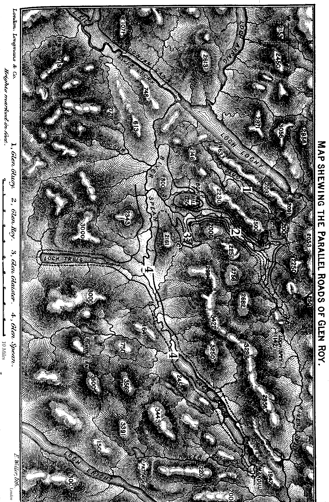
A map of the district, with the parallel roads shown in red, is annexed. [Transcriber's note: Sorry! No red available to show the line on the map; you will have to deduce the course of the roads from the contours etc.]
.
LITERATURE OF THE SUBJECT.
THOMAS PENNANT. — A Tour in Scotland. Vol. iii. 1776, p. 394. JOHN MACCULLOCH. — On the Parallel Roads of Glen Roy. Geol. Soc. Trans. vol. iv. 1817, p. 314.
THOMAS LAUDER DICK (afterwards SIR THOMAS DICK-LAUDER, Bart.) — On the Parallel Roads of Lochaber. Edin. Roy. Soc. Trans. 1818, vol. ix. p. 1.
CHARLES DARWIN. — Observations on the Parallel Roads of Glen Roy, and of the other parts of Lochaber in Scotland, with an attempt to prove that they are of marine origin. Phil. Trans. 1839, vol. cxxix. p. 39.
SIR CHARLES LYELL. — Elements of Geology. Second edition, 1841.
Louis AGASSIZ. — The Glacial Theory and its Recent Progress — Parallel Terraces. Edin. New Phil. Journal, 1842, vol. xxxiii. p. 236.
DAVID MILNE (afterwards DAVID MILNE-HOME). — On the Parallel Roads of Lochaber; with Remarks on the Change of Relative Levels of Sea and Land in Scotland, and on the Detrital Deposits in that Country. Edin. Roy. Soc. Trans. 1847, vol. xvi. p. 395.
ROBERT CHAMBERS. — Ancient Sea Margins. Edinburgh, 1848.
H. D. ROGERS. — On the Parallel Roads of Glen Roy. Royal Inst. Proceedings, 1861, vol. iii. p. 341.
THOMAS F. JAMIESON. — On the Parallel Roads of Glen Roy, and their Place in the History of the Glacial Period. Quart. Journal Geol. Soc. 1863, vol. xix. p. 235.
SIR CHARLES LYELL. — Antiquity of Man. 1863, p. 253.
REV. R. B. WATSON. — On the Marine Origin of the Parallel Roads of Glen Roy. Quart. Journ. Geol. Soc. 1865, vol. xxii. p. 9.
SIR JOHN LUBBOCK. — On the Parallel Roads of Glen Roy. Quart. Journ. Geol. Soc. 1867, vol. xxiv. p. 83.
CHARLES BABBAGE. — Observations on the Parallel Roads of Glen Roy. Quart. Journ. Geol. Soc. 1868, vol. xxiv. p. 273.
JAMES NICOL. — On the Origin of the Parallel Roads of Glen Roy. 1869. Geol. Soc. Journal, vol. xxv. p. 282.
JAMES NICOL. — How the Parallel Roads of Glen Roy were formed. 1872. Geol. Soc. Journal, vol. xxviii. p. 237.
MAJOR-GENERAL SIR HENRY JAMES, R.E. — Notes on the Parallel Roads of Lochaber. 4to. 1874.
.
.
.
.
--------------------
.
.
IX. ALPINE SCULPTURE.
1864.
TO account for the conformation of the Alps, two hypotheses have been advanced, which may be respectively named the hypothesis of fracture and the hypothesis of erosion. The former assumes that the forces by which the mountains were elevated produced fissures in the earth's crust, and that the valleys of the Alps are the tracks of these fissures; while the latter maintains that the valleys have been cut out by the action of ice and water, the mountains themselves being the residual forms of this grand sculpture. I had heard the Via Mala cited as a conspicuous illustration of the fissure theory — the profound chasm thus named, and through which the Hinter-Rhein now flows, could, it was alleged, be nothing else than a crack in the earth's crust. To the Via Mala I therefore went in 1864 to instruct myself upon the point in question.
The gorge commences about a quarter of an hour above Tusis; and, on entering it, the first impression certainly is that it must be a fissure. This conclusion in my case was modified as I advanced. Some distance up the gorge I found upon the slopes to my right quantities of rolled stones, evidently rounded by water-action. Still further up, and just before reaching the first bridge which spans the chasm, I found more rolled stones, associated with sand and gravel. Through this mass of detritus, fortunately, a vertical cutting had been made, which exhibited a section showing perfect stratification. There was no agency in the place to roll these stones, and to deposit these alternating layers of sand and pebbles, but the river which now rushes some hundreds of feet below them. At one period of the Via Mala's history the river must have run at this high level. Other evidences of water-action soon revealed themselves. From the parapet of the first bridge I could see the solid rock 200 feet above the bed of the river scooped and eroded.
It is stated in the guide-books that the river, which usually runs along the bottom of the gorge, has been known almost to fill it during violent thunder-storms; and it may be urged that the marks of erosion which the sides of the chasm exhibit are due to those occasional floods. In reply to this, it may be stated that even the existence of such floods is not well authenticated, and that if the supposition were true, it would be an additional argument in favour of the cutting power of the river. For if floods operating at rare intervals could thus erode the rock, the same agency, acting without ceasing upon the river's bed, must certainly be competent to excavate it.
I proceeded upwards, and from a point near another bridge (which of them I did not note) had a fine view of a portion of the gorge. The river here runs at the bottom of a cleft of profound depth, but so narrow that it might be leaped across. That this cleft must be a crack is the impression first produced; but a brief inspection suffices to prove that it has been cut by the river. From top to bottom we have the unmistakable marks of erosion. This cleft was best seen on looking downwards from a point near the bridge; but looking upwards from the bridge itself, the evidence of aqueous erosion was equally convincing.
The character of the erosion depends upon the rock as well as upon the river. The action of water upon some rocks is almost purely mechanical; they are simply ground away or detached in sensible masses. Water, however, in passing over limestone, charges itself with carbonate of lime without damage to its transparency; the rock is dissolved in the water; and the gorges cut by water in such rocks often resemble those cut in the ice of glaciers by glacier streams. To the solubility of limestone is probably to be ascribed the fantastic forms which peaks of this rock usually assume, and also the grottos and caverns which interpenetrate limestone formations. A rock capable of being thus dissolved will expose a smooth surface after the water has quitted it; and in the case of the Via Mala it is the polish of the surfaces and the curved hollows scooped in the sides of the gorge, which assure us that the chasm has been the work of the river.
About four miles from Tusis, and not far from the little village of Zillis, the Via Mala opens into a plain bounded by high terraces. It occurred to me the moment I saw it that the plain had been the bed of an ancient lake; and a farmer, who was my temporary companion, immediately informed me that such was the tradition of the neighbourhood. This man conversed with intelligence, and as I drew his attention to the rolled stones, which rest not only above the river, but above the road, and inferred that the river must once have been there to have rolled those stones, he saw the force of the evidence perfectly. In fact, in former times, and subsequent. to the retreat of the great glaciers, a rocky barrier crossed the valley at this place, damming the river which came from the mountains higher up. A lake was thus formed which poured its waters over the barrier. Two actions were here at work, both tending to obliterate the lake — the raising of its bed by the deposition of detritus, and the cutting of its dam by the river. In process of time the cut deepened into the Via Mala; the lake was drained, and the river now flows in a definite channel through the plain which its waters once totally covered.
From Tusis I crossed to Tiefenkasten by the Schien Pass, and thence over the Julier Pass to Pontresina. There are three or four ancient lake-beds between Tiefenkasten and the summit of the Julier. They are all of the same type — a more or less broad and level valley-bottom, with a barrier in front through which the river has cut a passage, the drainage of the lake being the consequence. These lakes were sometimes dammed by barriers of rock, sometimes by the moraines of ancient glaciers.
An example of this latter kind occurs in the Rosegg valley, about twenty minutes below the end of the Rosegg glacier, and about an hour from Pontresina. The valley here is crossed by a pine-covered moraine of the noblest dimensions; in the neighbourhood of London it might be called a mountain. That it is a moraine, the inspection of it from a point on the Surlei slopes above it will convince any person possessing an educated eye. Where, moreover, the interior of the mound is exposed, it exhibits moraine-matter — detritus pulverised by the ice, with boulders entangled in it. It stretched quite across the valley, and at one time dammed the river up. But now the barrier is cut through, the stream having about one-fourth of the moraine to its right, and the remaining three-fourths to its left. Other moraines of a more resisting character hold their ground as barriers to the present day.
In the Val di Campo, for example, about three-quarters of an hour from Pisciadello, there is a moraine composed of large boulders, which interrupt the course of a river and compel the water to fall over them in cascades. They have in great part resisted its action since the retreat of the ancient glacier which formed the moraine. Behind the moraine is a lake-bed, now converted into a level meadow, which rests on a deep layer of mould.
At Pontresina a very fine and instructive gorge is to be seen. The river from the Morteratsch glacier rushes through a deep and narrow chasm which is spanned at one place by a stone bridge. The rock is not of a character to preserve smooth polishing; but the larger features of water-action are perfectly evident from top to bottom. Those features are in part visible from the bridge, but still better from a point a little distance from the bridge in the direction of the upper village of Pontresina. The hollowing out of the rock by the eddies of the water is here quite manifest. A few minutes' walk upwards brings us to the end of the gorge; and behind it we have the usual indications of an ancient lake, and terraces of distinct water origin. From this position indeed the genesis of the gorge is clearly revealed. After the retreat of the ancient glacier, a transverse ridge of comparatively resisting material crossed the valley at this place. Over the lowest part of this ridge the river flowed, rushing steeply down to join at the bottom of the slope the stream which issued from the Rosegg glacier. On this incline the water became a powerful eroding agent, and finally cut the channel to its present depth.
Geological writers of reputation assume at this place the existence of a fissure, the 'washing out' of which resulted in the formation of the gorge. Now no examination of the bed of the river ever proved the existence of this fissure; and it is certain that water, particularly when charged with solid matter in suspension, can cut a channel through unfissured rock. Cases of deep cutting can be pointed out where the clean bed of the stream is exposed, the rock which forms the floor of the river not exhibiting a trace of fissure. An example of this kind on a small scale occurs near the Bernina Gasthaus, about two hours from Pontresina. A little way below the junction of the two streams from. the Bernina Pass and the Heuthal the river flows through a channel cut by itself, and 20 or 30 feet in depth. At some places the river-bed is covered with rolled stones; at other places it is bare, but shows no trace of fissure. The abstract power of water, if I may use the term, to cut through rock is demonstrated by such instances. But if water be competent to form a gorge without the aid of a fissure, why assume the existence of such fissures in cases like that at Pontresina? It seems far more philosophical to accept the simple and impressive history written on the walls of those gorges by the agent which produced them.
Numerous cases might be pointed out, varying in magnitude, but all identical in kind, of barriers which crossed valleys and formed lakes having been cut through by rivers, narrow gorges being the consequence. One of the most famous examples of this kind is the Finsteraarschlucht in the valley of Hash. Here the ridge called the Kirchet seems split across, and the river Aar rushes through the fissure. Behind the barrier we have the meadows and pastures of Imhof resting on the sediment of an ancient lake. Were this an isolated case, one might with an apparent show of reason conclude that the Finsteraarschlucht was produced by an earthquake, as some suppose it to have been; but when we find it to be a single sample of actions which are frequent in the Alps — when probably a hundred cases of the same kind, though different in magnitude, can be pointed out — it seems quite unphilosophical to assume that in each particular case an earthquake was at hand to form a channel for the river. As in the case of the barrier at Pontresina, the Kirchet, after the retreat of the Aar glacier, dammed the waters flowing from it, thus forming a lake, on the bed of which now stands the village of Imhof. Over this barrier the Aar tumbled towards Meyringen, cutting, as the centuries passed, its bed ever deeper, until finally it became deep enough to drain the lake, leaving in its place the alluvial plain, through which the river now flows in a definite channel.
In 1866 I subjected the Finsteraarschlucht to a close examination. The earthquake theory already adverted to was then prevalent regarding it, and I wished to see whether any evidences existed of aqueous erosion. Near the summit of the Kirchet is a signboard inviting the traveller to visit the Aarenschlucht, a narrow lateral gorge which runs down to the very bottom of the principal one. The aspect of this smaller chasm from bottom to top proves to demonstration that water had in former ages been there at work. It is scooped, rounded, and polished, so as to render palpable to the most careless eye that it is a gorge of erosion. But it was regarding the sides of the great chasm that instruction was needed, and from its edge nothing to satisfy me could be seen. I therefore stripped and waded into the river until a point was reached which commanded an excellent view of both sides of the gorge. The water was cutting cold, but I was repaid. Below me on the left-hand side was a jutting cliff which bore the thrust of the river and caused the Aar to swerve from its direct course. From top to bottom this cliff was polished, rounded, and scooped. There was no room for doubt. The river which now runs so deeply down had once been above. It has been the delver of its own channel through the barrier of the Kirchet.
But the broad view taken by the advocates of the fracture theory is, that the valleys themselves follow the tracks of primeval fissures produced by the upheaval of the land, the cracks across the barriers referred to being in reality portions of the great cracks which formed the valleys. Such an argument, however, would virtually concede the theory of erosion as applied to the valleys of the Alps. The narrow gorges, often not more than twenty or thirty feet across, sometimes even narrower, frequently occur at the bottom of broad valleys. Such fissures might enter into the list of accidents which gave direction to the real erosive agents which scooped the valley out; but the formation of the valley, as it now exists, could no more be ascribed to such cracks than the motion of a railway train could be ascribed to the finger of the engineer which turns on the steam.
These deep gorges occur, I believe, for the most part in limestone strata; and the effects which the merest driblet of water can produce on limestone are quite astonishing. It is not uncommon to meet chasms of considerable depth produced by small streams the beds of which are dry for a large portion of the year. Right and left of the larger gorges such secondary chasms are often found. The idea of time must, I think, be more and more included in our reasonings on these phenomena. Happily, the marks which the rivers have, in most cases, left behind them, and which refer, geologically considered, to actions of yesterday, give us ground and courage to conceive what may be effected in geologic periods. Thus the modern portion of the Via Mala throws light upon the whole. Near Bergün, in the valley of the Albula, there is also a little Via Mala, which is not less significant than the great one. The river flows here through a profound limestone gorge, and to the very edges of the gorge we have the evidences of erosion. But the most striking illustration of water-action upon limestone rock that I have ever seen is the gorge at Pfaeffers. Here the traveller passes along the side of the chasm midway between top and bottom. Whichever way he looks, backwards or forwards, upwards or downwards, towards the sky or towards the river, he meets everywhere the irresistible and impressive evidence that this wonderful fissure has been sawn through the mountain by the waters of the Tamina.
I have thus far confined myself to the consideration of the gorges formed by the cutting through of the rock-barriers which frequently cross the valleys of the Alps; as far as they have been examined by me they are the work of erosion. But the larger question still remains, To what action are we to ascribe the formation of the valleys themselves? This question includes that of the formation of the mountain-ridges, for were the valleys wholly filled, the ridges would disappear. Possibly no answer can be given to this question which is not beset with more or less of difficulty. Special localities might be found which would seem to contradict every solution which, refers the conformation of the Alps to the operation of a single cause.
Still the Alps present features of a character sufficiently definite to bring the question of their origin within the sphere of close reasoning. That they were in whole or in part once beneath the sea will not be disputed; for they are in great part composed of sedimentary rocks which required a sea to form them. Their present elevation above the sea is due to one of those local changes in the shape of the earth which have been of frequent occurrence throughout geologic time, in some cases depressing the land, and in others causing the sea-bottom to protrude beyond its surface. Considering the inelastic character of its materials, the protuberance of the Alps could hardly have been pushed out without dislocation and fracture; and this conclusion gains in probability when we consider the foldings, contortions, and even reversals in position of the strata in many parts of the Alps. Such changes in the position of beds which were once horizontal could not have been effected without dislocation. Fissures would be produced by these changes; and such fissures, the advocates of the fracture theory contend, mark the positions of the valleys of the Alps.
Imagination is necessary to the man of science, and we could not reason on our present subject without the power of presenting mentally a picture of the earth's crust cracked and fissured by the forces which produced its upheaval. Imagination, however, must be strictly checked by reason and by observation. That fractures occurred cannot, I think, be doubted, but that the valleys of the Alps are thus formed is a conclusion not at all involved in the admission of dislocations. I never met with a precise statement of the manner in which the advocates of the fissure theory suppose the forces to have acted — whether they assume a general elevation of the region, or a local elevation of distinct ridges; or whether they assume local subsidences after a general elevation, or whether they would superpose upon the general upheaval minor and local upheavals.
In the absence of any distinct statement, I will assume the elevation to be general — that a swelling out of the earth's crust occurred here, sufficient to place the most prominent portions of the protuberance three miles above the sea-level. To fix the ideas, let us consider a circular portion of the crust, say one hundred miles in diameter, and let us suppose, in the first instance, the circumference of this circle to remain fixed, and that the elevation was confined to the space within it. The upheaval would throw the crust into a state of strain; and, if it were inflexible, the strain must be relieved by fracture. Crevasses would thus intersect the crust. Let us now enquire what proportion the area of these open fissures is likely to bear to the area of the unfissured crust. An approximate answer is all that is here required; for the problem is of such a character as to render minute precision unnecessary.
No one, I think, would affirm that the area of the fissures would be one-hundredth the area of the land. For let us consider the strain upon a single line drawn over the summit of the protuberance from a point on its rim to a point opposite. Regarding the protuberance as a spherical swelling, the length of the arc corresponding to a chord of 100 miles and a versed sine of 3 miles is 100.24 miles; consequently the surface to reach its new position must stretch 0.24 of a mile, or be broken. A fissure or a number of cracks with this total width would relieve the strain; that is to say, the sum of the widths of all the cracks over the length of 100 miles would be 420 yards. If, instead of comparing the width of the fissures with the length of the lines of tension, we compared their areas with the area of the unfissured land, we should of course find the proportion much less. These considerations will help the imagination to realise what a small ratio the area of the open fissures must bear to the unfissured crust. They enable us to say, for example, that to assume the area of the fissures to be one-tenth of the area of the land would be quite absurd, while that the area of the fissures could be one-half or more than one-half that of the land would be in a proportionate degree unthinkable. If we suppose the elevation to be due to the shrinking or subsidence of the land all round our assumed circle, we arrive equally at the conclusion that the area of the open fissures would be altogether insignificant as compared with that of the unfissured crust.
To those who have seen them from a commanding elevation, it is needless to say that the Alps themselves bear no sort of resemblance to the picture which this theory presents to us. Instead of deep cracks with approximately vertical walls, we have ridges running into peaks, and gradually sloping to form valleys. Instead of a fissured crust, we have a state of things closely resembling the surface of the ocean when agitated by a storm. The valleys, instead of being much narrower than the ridges, occupy the greater space. A plaster cast of the Alps turned upside down, so as to invert the elevations and depressions, would exhibit blunter and broader mountains, with narrower valleys between them, than the present ones. The valleys that exist cannot, I think, with any correctness of language be called fissures. It may be urged that they originated in fissures: but even this is unproved, and, were it proved, the fissures would still play the subordinate part of giving direction to the agents which are to be regarded as the real sculptors of the Alps.
The fracture theory, then, if it regards the elevation of the Alps as due to the operation of a force acting throughout the entire region, is, in my opinion, utterly incompetent to account for the conformation of the country. If, on the other hand, we are compelled to resort to local disturbances, the manipulation of the earth's crust necessary to obtain the valleys and the mountains will, I imagine, bring the difficulties of the theory into very strong relief. Indeed an examination of the region from many of the more accessible eminences — from the Galenstock, the Grauhaupt, the Pitz Languard, the Monte Confinale — or, better still, from Mont Blanc, Monte Rosa, the Jungfrau, the Finsteraarhorn, the Weisshorn, or the Matterhorn, where local peculiarities are toned down, and the operations of the powers which really made this region what it is are alone brought into prominence — must, I imagine, convince every physical geologist of the inability of any fracture theory to account for the present conformation of the Alps.
A correct model of the mountains, with an unexaggerated vertical scale, produces the same effect upon the mind as the prospect from one of the highest peaks. We are apt to be influenced by local phenomena which, though insignificant in view of the general question of Alpine conformation, are, with reference to our customary standards, vast and impressive. In a true model those local peculiarities disappear; for on the scale of a model they are too small to be visible; while the essential facts and forms are presented to the undistracted attention.
A minute analysis of the phenomena strengthens the conviction which the general aspect of the Alps fixes in the mind. We find, for example, numerous valleys which the most ardent plutonist would not think of ascribing to any other agency than erosion. That such is their genesis and history is as certain as that erosion produced the Chines in the Isle of Wight. From these indubitable cases of erosion — commencing, if necessary, with the small ravines which run down the flanks of the ridges, with their little working navigators at their bottoms — we can proceed, by almost insensible gradations, to the largest valleys of the Alps; and it would perplex the plutonist to fix upon the point at which fracture begins to play a material part.
In ascending one of the larger valleys, we enter it where it is wide and where the eminences are gentle on either side. The flanking mountains become higher and more abrupt as we ascend, and at length we reach a place where the depth of the valley is a maximum. Continuing our walk upwards, we find ourselves flanked by gentler slopes, and finally emerge from the valley and reach the summit of an open col, or depression in the chain of mountains. This is the common character of the large valleys. Crossing the col, we descend along the opposite slope of the chain, and through the same series of appearances in the reverse order. If the valleys on both sides of the col were produced by fissures, what prevents the fissure from prolonging itself across the col? The case here cited is representative; and I am not acquainted with a single instance in the Alps where the chain has been cracked in the manner indicated. The cols are simply depressions; in many of which the unfissured rock can be traced from side to side.
The typical instance just sketched follows as a natural consequence from the theory of erosion. Before either ice or water can exert great power as an erosive agent, it must collect in sufficient mass. On the higher slopes and plateaus — in the region of cols — the power is not fully developed; but lower down tributaries unite, erosion is carried on with increased vigour, and the excavation gradually reaches a maximum. Lower still the elevations diminish and the slopes become more gentle; the cutting power gradually relaxes, until finally the eroding agent quits the mountains altogether, and the grand effects which it produced in the earlier portions of its course entirely disappear.
I have hitherto confined myself to the consideration of the broad question of the erosion theory as compared with the fracture theory; and all that I have been able to observe and think with reference to the subject leads me to adopt the former. Under the term erosion I include the action of water, of ice, and of the atmosphere, including frost and rain. Water and ice, however, are the principal agents, and which of these two has produced the greatest effect it is perhaps impossible to say. Two years ago I wrote a brief note 'On the Conformation of the Alps,' [Footnote: Phil. Mag. vol. xxiv. p. 169] in which I ascribed the paramount influence to glaciers. The facts on which that opinion was founded are, I think, unassailable; but whether the conclusion then announced fairly follows from the facts is, I confess, an open question.
The arguments which have been thus far urged against the conclusion are not convincing. Indeed, the idea of glacier erosion appears so daring to some minds that its boldness alone is deemed its sufficient refutation. It is, however, to be remembered that a precisely similar position was taken up by many excellent workers when the question of ancient glacier extension was first mooted. The idea was considered too hardy to be entertained; and the evidences of glacial action were sought to be explained by reference to almost any process rather than the true one. Let those who so wisely took the side of 'boldness' in that discussion beware lest they place themselves, with reference to the question of glacier erosion, in the position formerly occupied by their opponents.
Looking at the little glaciers of the present day — mere pigmies as compared to the giants of the glacial epoch — we find that from every one of them issues a river more or less voluminous, charged with the matter which the ice has rubbed from the rocks. Where the rocks are soft, the amount of this finely pulverised matter suspended in the water is very great. The water, for example, of the river which flows from Santa Catarina to Bormio is thick with it. The Rhine is charged with this matter, and by it has so silted up the Lake of Constance as to abolish it for a large fraction of its length. The Rhone is charged with it, and tens of thousands of acres of cultivable land are formed by the silt above the Lake of Geneva.
In the case of every glacier we have two agents at work — the ice exerting a crushing force on every point of its bed which bears its weight, and either rasping this point into powder or tearing it bodily from the rock to which it belongs; while the water which everywhere circulates upon the bed of the glacier continually washes the detritus away and leaves the rock clean for further abrasion. Confining the action of glaciers to the simple rubbing away of the rocks, and allowing them sufficient time to act, it is not a matter of opinion, but a physical certainty, that they will scoop out valleys. But the glacier does more than abrade. Rocks are not homogeneous; they are intersected by joints and places of weakness, which divide them into virtually detached masses. A glacier is undoubtedly competent to root such masses bodily away. Indeed the mere à priori consideration of the subject proves the competence of a glacier to deepen its bed. Taking the case of a glacier 1,000 feet deep (and some of the older ones were probably three times this depth), and allowing 40 feet of ice to an atmosphere, we find that on every square inch of its bed such a glacier presses with a weight of 375 lbs., and on every square yard of its bed with a weight of 486,000 lbs. With a vertical pressure of this amount the glacier is urged down its valley by the pressure from behind. We can hardly, I think, deny to such a tool a power of excavation.
The retardation of a glacier by its bed has been referred to as proving its impotence as an erosive agent; but this very retardation is in some measure an expression of the magnitude of the erosive energy. Either the bed must give way, or the ice must slide over itself. We get indeed some idea of the crushing pressure which the moving glacier exercises against its bed-from the fact that the resistance, and the effort to overcome it, are such as to make the upper layers of a glacier move bodily over the lower ones — a portion only of the total motion being due to the progress of the entire mass of the glacier down its valley.
The sudden bend in the valley of the Rhone at Martigny has also been regarded as conclusive evidence against the theory of erosion. 'Why,' it has been asked, I did not the glacier of the Rhone go straight forward instead of making this awkward bend?' But if the valley be a crack, why did the crack make this bend? The crack, I submit, had at least as much reason to prolong itself in a straight line as the glacier had. A statement of Sir John Herschel with reference to another matter is perfectly applicable here: 'A crack once produced has a tendency to run — for this plain reason, that at its momentary limit, at the point at which it has just arrived, the divellent force on the molecules there situated is counteracted only by half of the cohesive force which acted when there was no crack, viz. the cohesion of the uncracked portion alone' ('Proc. Roy. Soc.' vol. xii. p. 678). To account, then, for the bend, the adherent of the fracture theory must assume the existence of some accident which turned the crack at right angles to itself; and he surely will permit the adherent of the erosion theory to make a similar assumption.
The influence of small accidents on the direction of rivers is beautifully illustrated in glacier streams, which are made to cut either straight or sinuous channels by causes apparently of the most trivial character. In his interesting paper 'On the Lakes of Switzerland,' M. Studer also refers to the bend of the Rhine at Sargans in proof that the river must there follow a pre-existing fissure. I made a special expedition to the place in 1864; and though it was plain that M. Studer had good grounds for the selection of this spot, I was unable to arrive at his conclusion as to the necessity of a fissure.
Again, in the interesting volume recently published by the Swiss Alpine Club, M. Desor informs us that the Swiss naturalists who met last year at Samaden visited the end of the Morteratsch glacier, and there convinced themselves that a glacier had no tendency whatever to imbed itself in the soil. I scarcely think that the question of glacier erosion, as applied either to lakes or valleys, is to be disposed of so easily. Let me record here my experience of the Morteratsch glacier.
I took with me in 1864 a theodolite to Pontresina, and while there had to congratulate myself on the aid of my friend Mr. Hirst, who in 1857 did such good service upon the Mer de Glace and its tributaries. We set out three lines across the Morteratsch glacier, one of which crossed the ice-stream near the well-known hut of the painter Georgei, while the two others were staked out, the one above the hut and the other below it. Calling the highest line A, the line which crossed the glacier at the hut B, and the lowest line C, the following are the mean hourly motions of the three lines, deduced from observations which extended over several days. On each line eleven stakes were fixed, which are designated by the figures 1, 2, 3, &c. in the Tables.
Morteratsch Glacier, Line A.
No. of Stake. Hourly Motion.
1 0.35 inch.
2 0.49 inch.
3 0.53 inch.
4 0.54 inch.
5 0.56 inch.
6 0.54 inch.
7 0.52 inch.
8 0.49 inch.
9 0.40 inch.
10 0.29 inch.
11 0.20 inch.
As in all other measurements of this kind, the retarding influence of the sides of the glacier is manifest: the centre moves with the greatest velocity.
Morteratsch Glacier, Line B.
No. of Stake. Hourly Motion.
1 0.05 inch.
2 0.14 inch.
3 0.24 inch.
4 0.32 inch.
5 0-41 inch.
6 0.44 inch.
7 0.44 inch.
8 0.45 inch.
9 0.43 inch.
10 0.44 inch.
11 0.44 inch.
The first stake of this line was quite close to the edge of the glacier, and the ice was thin at the place, hence its slow motion. Crevasses prevented us from carrying the line sufficiently far across to render the retardation of the further side of the glacier fully evident.
Morteratsch Glacier, Line C.
No. of Stake Hourly Motion.
1 0.05 inch.
2 0.09 inch.
3 0.18 inch.
4 0.20 inch.
5 0.25 inch.
6 0.27 inch.
7 0.27 inch.
8 0.30 inch.
9 0.21 inch.
10 0.20 inch.
11 0.16 inch.
Comparing the three lines together, it will be observed that the velocity diminishes as we descend the glacier. In 100 hours the maximum motion of three lines respectively is as follows:
Maximum Motion in 100 hours.
Line A 56 inches
Line B 45 inches.
Line C 30 inches.
This deportment explains an appearance which must strike every observer who looks upon the Morteratsch from the Piz Languard, or from the new Bernina Road. A medial moraine runs along the glacier, commencing as a narrow streak, but towards the end the moraine extending in width, until finally it quite covers the terminal portion of the glacier. The cause of this is revealed by the foregoing measurements, which prove that a stone on the moraine where it is crossed by the line A approaches a second stone on the moraine where it is crossed by the line C with a velocity of twenty-six inches per one hundred hours. The moraine is in a state of longitudinal compression. Its materials are more and more squeezed together, and they must consequently move laterally and render the moraine at the terminal portion of the glacier wider than above.
The motion of the Morteratsch glacier, then, diminishes as we descend. The maximum motion of the third line is thirty inches in one hundred hours, or seven inches a day — a very slow motion; and had we run a line nearer to the end of the glacier, the motion would have been slower still. At the end itself it is nearly insensible. [Footnote: The snout of the Aletsch Glacier has a diurnal motion of less than two inches, while a mile or so above the snout the velocity is eighteen inches. The spreading out of the moraine is here very striking.] Now I submit that this is not the Place to seek for the scooping power of a glacier. The opinion appears to be prevalent that it is the snout of a glacier that must act the part of ploughshare; and it is certainly an erroneous opinion. The scooping power will exert itself most where the weight and the motion are greatest. A glacier's snout often rests upon matter which has been scooped from the glacier's bed higher up. I therefore do not think that the inspection of what the end of a glacier does or does not accomplish can decide this question.
The snout of a glacier is potent to remove anything against which it can fairly abut; and this power, notwithstanding the slowness of the motion, manifests itself at the end of the Morteratsch glacier. A hillock, bearing pine-trees, was in front of the glacier when Mr. Hirst and myself inspected its end; and this hillock is being bodily removed by the thrust of the ice. Several of the trees are overturned; and in a few years, if the glacier continues its reputed advance, the mound will certainly be ploughed away.
The question of Alpine conformation stands, I think, thus: We have, in the first place, great valleys, such as those of the Rhine and the Rhone, which we might conveniently call valleys of the first order. The mountains which flank these main valleys are also cut by lateral valleys running into the main ones, and which may be called valleys of the second order. When these latter are examined, smaller valleys are found running into them, which may be called valleys of the third order. Smaller ravines and depressions, again, join the latter, which may be called valleys of the fourth order, and so on until we reach streaks and cuttings so minute as not to merit the name of valleys at all. At the bottom of every valley we have a stream, diminishing in magnitude as the order of the valley ascends, carving the earth and carrying its materials to lower levels. We find that the larger valleys have been filled for untold ages by glaciers of enormous dimensions, always moving, grinding down and tearing away the rocks over which they passed. We have, moreover, on the plains at the feet of the mountains, and in enormous quantities, the very matter derived from the sculpture of the mountains themselves.
The plains of Italy and Switzerland are cumbered by the débris of the Alps. The lower, wider, and more level valleys are also filled to unknown depths with the materials derived from the higher ones. In the vast quantities of moraine-matter which cumber many even of the higher valleys we have also suggestions as to the magnitude of the erosion which has taken place. This moraine-matter, moreover, can only in small part have been derived from the falling of rocks upon the ancient glacier; it is in great part derived from the grinding and the ploughing-out of the glacier itself. This accounts for the magnitude of many of the ancient moraines, which date from a period when almost all the mountains were covered with ice and snow, and when, consequently, the quantity of moraine-matter derived from the naked crests cannot have been considerable.
The erosion theory ascribes the formation of Alpine valleys to the agencies here briefly referred to. It invokes nothing but true causes. Its artificers are still there, though, it may be, in diminished strength; and if they are granted sufficient time, it is demonstrable that they are competent to produce the effects ascribed to them. And what does the fracture theory offer in comparison? From no possible application of this theory, pure and simple, can we obtain the slopes and forms of the mountains. Erosion must in the long run be invoked, and its power therefore conceded. The fracture theory infers from the disturbances of the Alps the existence of fissures; and this is a probable inference. But that they were of a magnitude sufficient to produce the conformation of the Alps, and that they followed, as the Alpine valleys do, the lines of natural drainage of the country, are assumptions which do not appear to me to be justified either by reason or by observation.
There is a grandeur in the secular integration of small effects implied by the theory of erosion almost superior to that involved in the idea of a cataclysm. Think of the ages which must have been consumed in the execution of this colossal sculpture. The question may, of course, be pushed further. Think of the ages which the molten earth required for its consolidation. But these vaster epochs lack sublimity through our inability to grasp them. They bewilder us, but they fail to make a solemn impression. The genesis of the mountains comes more within the scope of the intellect, and the majesty of the operation is enhanced by our partial ability to conceive it. In the falling of a rock from a mountain-head, in the shoot of an avalanche, in the plunge of a cataract, we often see more impressive illustrations of the power of gravity than in the motions of the stars. When the intellect has to intervene, and calculation is necessary to the building up of the conception, the expansion of the feelings ceases to be proportional to the magnitude of the phenomena.
-----
I will here record a few other measurements executed on the Rosegg glacier: the line was staked out across the trunk formed by the junction of the Rosegg proper with the Tschierva glacier, a short distance below the rocky promontory called Agaliogs.
Rosegg Glacier.
No. of Stake. Hourly Motion.
1 0.01 inch.
2 0.05
3 0.07
4 0.10
5 0.11
6 0.13
7 0.14
8 0.18
9 0.24
10 0.23
11 0.24
This is an extremely slowly moving glacier; the maximum motion hardly amounts to seven inches a day. Crevasses prevented us from continuing the line quite across the glacier.
.
.
.
.
--------------------
.
.
X. RECENT EXPERIMENTS ON FOG-SIGNALS.
[Footnote: A discourse delivered in the Royal Institution, March 22, 1878.]
The care of its sailors is one of the first duties of a maritime people, and one of the sailor's greatest dangers is his proximity to the coast at night. Hence, the idea of warning him of such proximity by beacon-fires placed sometimes on natural eminences and sometimes on towers built expressly for the purpose. Close to Dover Castle, for example, stands an ancient Pharos of this description.
As our marine increased greater skill was invoked, and lamps reinforced by parabolic reflectors poured their light upon the sea. Several of these lamps were sometimes grouped together so as to intensify the light, which at a little distance appeared as if it emanated from a single source. This 'catoptric' form of apparatus is still to some extent employed in our lighthouse-service, but for a long time past it has been more and more displaced by the great lenses devised by the illustrious Frenchman, Fresnel.
In a first-class 'dioptric' apparatus the light emanates from a lamp with several concentric wicks, the flame of which, being kindled by a very active draught, attains to great intensity. In fixed lights the lenses refract the rays issuing from the lamp so as to cause them to form a luminous sheet which grazes the sea-horizon. In revolving lights the lenses gather up the rays into distinct beams, resembling the spokes of a wheel, which sweep over the sea and strike the eye of the mariner in succession.
It is not for clear weather that the greatest strengthening of the light is intended, for here it is not needed. Nor is it for densely foggy weather, for here it is ineffectual. But it is for the intermediate stages of hazy, snowy, or rainy weather, in which a powerful light can assert itself, while a feeble one is extinguished. The usual first-order lamp is one of four wicks, but Mr. Douglass, the able and indefatigable engineer of the Trinity House, has recently raised the number of the wicks to six, which produce a very noble flame. To Mr. Wigham, of Dublin, we are indebted for the successful application of gas to lighthouse illumination. In some lighthouses his power varies from 28 jets to 108 jets, while in the lighthouse of Galley Head three burners of the largest size can be employed, the maximum number of jets being 324. These larger powers are invoked only in case of fog, the 28-jet burner being amply sufficient for clear weather. The passage from the small burner to the large, and from the large burner to the small, is made with ease, rapidity, and certainty. This employment of gas is indigenous to Ireland, and the Board of Trade has exercised a wise liberality in allowing every facility to Mr. Wigham for the development of his invention.
The last great agent employed in lighthouse illumination is electricity. It was in this Institution, beginning in 1831, that Faraday proved the existence and illustrated the laws of those induced currents which in our day have received such astounding development. In relation to this subject Faraday's words have a prophetic ring. 'I have rather,' he writes in 1831, 'been desirous of discovering new facts and new relations dependent on magneto-electric induction than of exalting the force of those already obtained, being assured that the latter would find their full development hereafter.' The labours of Holmes, of the Paris Alliance Company, of Wilde, and of Gramme, constitute a brilliant fulfilment of this prediction.
But, as regards the augmentation of power, the greatest step hitherto made was independently taken a few years ago by Dr. Werner Siemens and Sir Charles Wheatstone. Through the application of their discovery a machine endowed with an infinitesimal charge of magnetism may, by a process of accumulation at compound interest, be caused so to enrich itself magnetically as to cast by its performance all the older machines into the shade. The light now before you is that of a small machine placed downstairs, and worked there by a minute steam-engine. It is a light of about 1000 candles; and for it, and for the steam-engine that 'works it, our members are indebted to the liberality of Dr. William Siemens, who in the most generous manner has presented the machine to this Institution. After an exhaustive trial at the South Foreland, machines on the principle of Siemens, but of far greater power than this one, have been recently chosen by the Elder Brethren of the Trinity House for the two light-houses at the Lizard Point.
Our most intense lights, including the six-wick lamp, the Wigham gas-light, and the electric light, being intended to aid the mariner in heavy weather, may be regarded, in a certain sense, as fog-signals. But fog, when thick, is intractable to light. The sun cannot penetrate it, much less any terrestrial source of illumination. Hence the necessity of employing sound-signals in dense fogs. Bells, gongs, horns, whistles, guns, and syrens have been used for this purpose; but it is mainly, if not wholly, with explosive signals that we have now to deal. The gun has been employed with useful effect at the North Stack, near Holyhead, on the Kish Bank near Dublin, at Lundy Island, and at other points on our coasts. During the long, laborious, and I venture to think memorable series of observations conducted under the auspices of the Elder Brethren of the Trinity House at the South Foreland in 1872 and 1873, it was proved that a short 5.5-inch howitzer, firing 3 lbs. of powder, yielded a louder report than a long 18-pounder firing the same charge. Here was a hint to be acted on by the Elder Brethren. The effectiveness of the sound depended on the shape of the gun, and as it could not be assumed that in the howitzer we had hit accidentally upon the best possible shape, arrangements were made with the War Office for the construction of a gun specially calculated to produce the loudest sound attainable from the combustion of 3 lbs. of powder. To prevent the unnecessary landward waste of the sound, the gun was furnished with a parabolic muzzle, intended to project the sound over the sea, where it was most needed. The construction of this gun was based on a searching series of experiments executed at Woolwich with small models, provided with muzzles of various kinds. A drawing of the gun is annexed (p. 309). It was constructed on the principle of the revolver, its various chambers being loaded and brought in rapid succession into the firing position. The performance of the gun proved the correctness of the principles on which its construction was based.
An incidental point of some interest was decided by the earliest Woolwich experiments. It had been a widely spread opinion among artillerists, that a bronze gun produces a specially loud report. I doubted from the outset whether this would help us; and in a letter dated 22nd April, 1874, I ventured to express myself thus :— 'The report of a gun, as affecting an observer close at hand, is made up of two factors — the sound due to the shock of the air by the violently expanding gas, and the sound derived from the vibrations of the gun, which, to some extent, rings like a bell. This latter, I apprehend, will disappear at considerable distances.'
FIG. 8. Breech-loading Fog-signal Gun, with Bell Mouth,
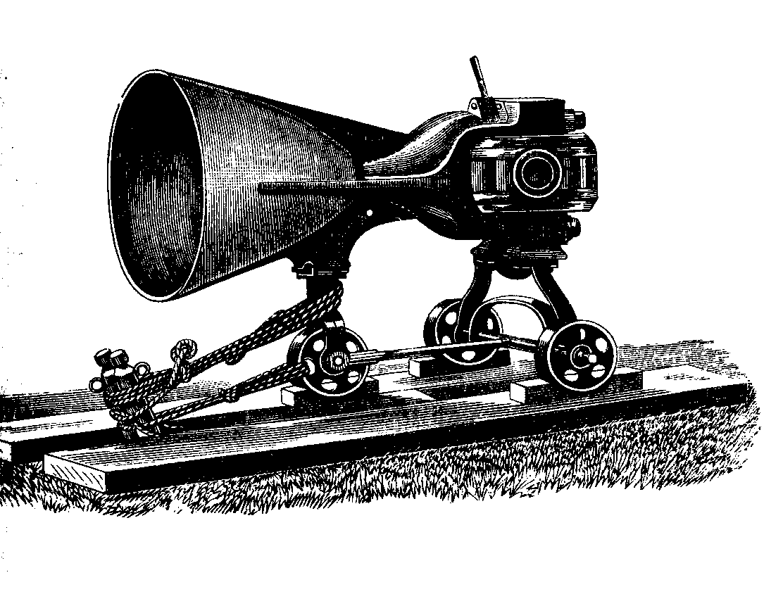
proposed by Major Maitland, R.A., Assistant Superintendent. [Footnote: The carriage of this gun has been modified in construction since this drawing was made.]
The result of subsequent trial, as reported by General Campbell, is, 'that the sonorous qualities of bronze are greatly superior to those of cast iron at short distances, but that the advantage lies with the baser metal at long ranges.' [Footnote: General Campbell assigns a true cause for this difference. The ring of the bronze gun represents so much energy withdrawn from the explosive force of the gunpowder. Further experiments would, however, be needed to place the superiority of the cast-iron gun at a distance beyond question.]
Coincident with these trials of guns at Woolwich, gun-cotton was thought of as a probably effective sound-producer. From the first, indeed, theoretic considerations caused me to fix my attention persistently on this substance; for the remarkable experiments of Mr. Abel, whereby its rapidity of combustion and violently explosive energy are demonstrated, seemed to single it out as a substance eminently calculated to fulfil the conditions necessary to the production of an intense wave of sound. What those conditions are we shall now more particularly enquire, calling to our aid a brief but very remarkable paper, published by Professor Stokes in the 'Philosophical Magazine' for 1868.
The explosive force of gunpowder is known to depend on the sudden conversion of a solid body into an intensely heated gas. Now the work which the artillerist requires the expanding gas to perform is the displacement of the projectile, besides which it has to displace the air in front of the projectile, which is backed by the whole pressure of the atmosphere. Such, however, is not the work that we want our gunpowder to perform. We wish to transmute its energy not into the mere mechanical translation of either shot or air, but into vibratory motion. We want pulses to be formed which shall propagate themselves to vast distances through the atmosphere, and this requires a certain choice and management of the explosive material.
A sound-wave consists essentially of two parts — a condensation and a rarefaction. Now air is a very mobile fluid, and if the shock imparted to it lack due promptness, the wave is not produced. Consider the case of a common clock pendulum, which oscillates to and fro, and which might be expected to generate corresponding pulses in the air. When, for example, the bob moves to the right, the air to the right of it might be supposed to be condensed, while a partial vacuum might be supposed to follow the bob. As a matter of fact, we have nothing of the kind. The air particles in front of the bob retreat so rapidly, and those behind it close so rapidly in, that no sound-pulse is formed. The mobility of hydrogen, moreover, being far greater than that of air, a prompter action is essential to the formation of sonorous waves in hydrogen than in air. It is to this rapid power of readjustment, this refusal, so to speak, to allow its atoms to be crowded together or to be drawn apart, that Professor Stokes, with admirable penetration, refers the damping power, first described by Sir John Leslie, of hydrogen upon sound.
A tuning-fork which executes 256 complete vibrations in a second, if struck gently on a pad and held in free air, emits a scarcely audible note. It behaves to some extent like the pendulum bob just referred to. This feebleness is due to the prompt 'reciprocating flow' of the air between the incipient condensations and rarefactions, whereby the formation of sound-pulses is forestalled. Stokes, however, has taught us that this flow may be intercepted by placing the edge of a card in close proximity to one of the corners of the fork. An immediate augmentation of the sound of the fork is the consequence.
The more rapid the shock imparted to the air, the greater is the fractional part of the energy of the shock converted into wave motion. And as different kinds of gunpowder vary considerably in their rapidity of combustion, it may be expected that they will also vary as producers of sound. This theoretic inference is completely verified by experiment. In a series of preliminary trials conducted at Woolwich on the 4th of June, 1875, the sound-producing powers of four different kinds of powder were determined. In the order of the size of their grains they bear the names respectively of Fine-grain (F.G.), Large-grain (L.G.), Rifle Large-grain (R.L.G.), and Pebble-powder (P.) (See annexed figures.) The charge in each case amounted to 4.5 lbs. four 24-lb. howitzers being employed to fire the respective charges.
FIG. 9.
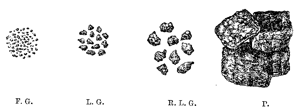
There were eleven observers, all of whom, without a single dissentient, pronounced the sound of the fine-grain powder loudest of all. In the opinion of seven of the eleven the large-grain powder came next; seven also of the eleven placed the rifle large-grain third on the list; while they were again unanimous in pronouncing the pebble-powder the worst sound-producer. These differences are entirely due to differences in the rapidity of combustion. All who have witnessed the performance of the 80-ton gun must have been surprised at the mildness of its thunder. To avoid the strain resulting from quick combustion, the powder employed is composed of lumps far larger than those of the pebble-powder above referred to. In the long tube of the gun these lumps of solid matter gradually resolve themselves into gas, which on issuing from the muzzle imparts a kind of push to the air, instead of the sharp shock necessary to form the condensation of an intensely sonorous wave.
These are some of the physical reasons why guncotton might be regarded as a promising fog-signal. Firing it as we have been taught to do by Mr. Abel, its explosion is more rapid than that of gunpowder. In its case the air particles, alert as they are, will not, it might be presumed, be able to slip from condensation to rarefaction with a rapidity sufficient to forestall the formation of the wave. On à priori grounds then, we are entitled to infer the effectiveness of gun-cotton, while in a great number of comparative experiments, stretching from 1874 to the present time, this inference has been verified in the most conclusive manner.
As regards explosive material, and zealous and accomplished help in the use of it, the resources of Woolwich Arsenal have been freely placed at the disposal of the Elder Brethren. General Campbell, General Younghusband, Colonel Fraser, Colonel Maitland, and other officers, have taken an active personal part in the investigation, and in most cases have incurred the labour of reducing and reporting on the observations. Guns of various forms and sizes have been invoked for gunpowder, while gun-cotton has been fired in free air and in the foci of parabolic reflectors.
On the 22nd of February, 1875, a number of small guns, cast specially for the purpose — some with plain, some with conical, and some with parabolic muzzles — firing 4 oz. of fine-grain powder, were pitted against 4 oz. of gun-cotton detonated both in the open, and in the focus of a parabolic reflector. [Footnote: For charges of this weight the reflector is of moderate size, and may be employed without fear of fracture.]
The sound produced by the gun-cotton, reinforced by the reflector, was unanimously pronounced loudest of all. With equal unanimity, the gun-cotton detonated in free air was placed second in intensity. Though the same charge was used throughout, the guns differed notably among themselves, but none of them came up to the gun-cotton, either with or without the reflector. A second series, observed from a different distance on the same day, confirmed to the letter the foregoing result.
As a practical point, however, the comparative cost of gun-cotton and gunpowder has to be taken into account, though considerations of cost ought not to be stretched too far in cases involving the safety of human life. In the earlier experiments, where quantities of equal price were pitted against each other, the results were somewhat fluctuating. Indeed, the perfect manipulation of the gun-cotton required some preliminary discipline — promptness, certainty, and effectiveness of firing, augmenting as experience increased. As 1 lb. of gun-cotton costs as much as 3 lbs. of gunpowder, these quantities were compared together on the 22nd of February. The guns employed to discharge the gunpowder were a 12-lb. brass howitzer, a 24-lb. cast-iron howitzer, and the long 18-pounder employed at the South Foreland. The result was, that the 24-lb. howitzer, firing 3 lbs. of gunpowder, had a slight advantage over 1 lb. of gun-cotton detonated in the open; while the 12-lb. howitzer and the 18-pounder were both beaten by the gun-cotton. On the end of May, on the other hand, the gun-cotton is reported as having been beaten by all the guns.
Meanwhile, the parabolic-muzzle gun, expressly intended for fog-signalling, was pushed rapidly forward, and on March 22 and 23, 1876, its power was tested at Shoeburyness. Pitted against it were a 16-pounder, a 5.5-inch howitzer, 1.5 lb. of gun-cotton detonated in the focus of a reflector (see annexed figure), and 1.5 lb. of gun-cotton detonated in free air. On this occasion nineteen different series of experiments were made, when the new experimental gun, firing a 3-lb. charge, demonstrated its superiority over all guns previously employed to fire the same charge. As regards the comparative merits of the gun-cotton fired in the open, and the gunpowder fired from the new gun, the mean values of their sounds were the same. Fired in the focus of the reflector, the gun-cotton clearly dominated over all the other sound-producers. [Footnote: The reflector was fractured by the explosion, but it did good service afterwards.]
FIG. 10.
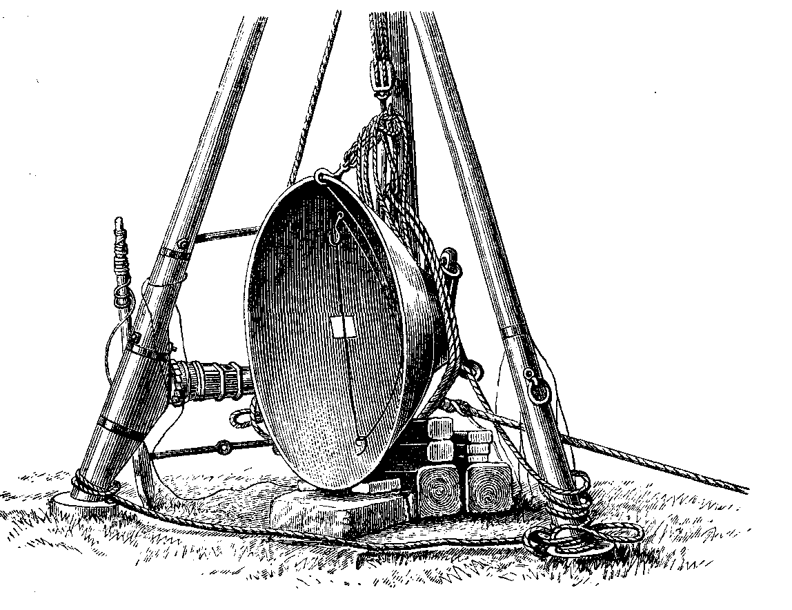
Gun-cotton Slab (1.5 lb.) Detonated in the Focus of a Cast-iron Reflector.
The whole of the observations here referred to were embraced by an angle of about 70°, of which 50' lay on the one side and 20° on the other side of the line of fire. The shots were heard by eleven observers on board the 'Galatea,' which took up positions varying from 2 miles to 13.5 miles from the firing-point. In all these observations, the reinforcing action of the reflector, and of the parabolic muzzle of the gun, came into play. But the reinforcement of the sound in one direction implies its withdrawal from some other direction, and accordingly it was found that at a distance of 5.25 miles from the firing-point, and on a line including nearly an angle of 90° with the line of fire, the gun-cotton in the open beat the new gun; while behind the station, at distances of 8.5 miles and 13.5 miles respectively, the gun-cotton in the open beat both the gun and the gun-cotton in the reflector. This result is rendered more important by the fact that the sound reached the Mucking Light, a distance of 13.5 miles, against a light wind which was blowing at the time.
Most, if not all, of our ordinary sound-producers send forth waves which are not of uniform intensity throughout. A trumpet is loudest in the direction of its axis. The same is true of a gun. A bell, with its mouth pointed upwards or downwards, sends forth waves which are far denser in the horizontal plane passing through the bell than at an angular distance of 90° from that plane. The oldest bellbangers must have been aware of the fact that the sides of the bell, and not its mouth, emitted the strongest sound, their practice being probably determined by this knowledge. Our slabs of gun-cotton also emit waves of different densities in different parts. It has occurred in the experiments at Shoeburyness that when the broad side of a slab was turned towards the suspending wire of a second slab six feet distant, the wire was cut by the explosion, while when the edge of the slab was turned to the wire this never occurred.
To the circumstance that the broadsides of the slabs faced the sea is probably to be ascribed the remarkable fact observed on March 23, that in two directions, not far removed from the line of fire, the gun-cotton detonated in the open had a slight advantage over the new gun.
Theoretic considerations rendered it probable that the shape and size of the exploding mass would affect the constitution of the wave of sound. I did not think large rectangular slabs the most favourable shape, and accordingly proposed cutting a large slab into fragments of different sizes, and pitting them against each other The differences between the sounds were by no means so great as the differences in the quantities of explosive material might lead one to expect. The mean values of eighteen series of observations made on board the 'Galatea,' at distances varying from 1.75 mile to 4.8 miles, were as follows:—
Weights 4 oz. 6 oz. 9 oz. 12 oz.
Value of sound 3.12 3.34 4.0 4.03
These charges were cut from a slab of dry gun-cotton about 1.75 inch thick: they were squares and rectangles of the following dimensions:-
4 oz., 2 inches by 2 inches;
6 oz., 2 inches by 3 inches;
9 oz., 3 inches by 3 inches;
12 oz., 2 inches by 6 inches.
The numbers under the respective weights express the recorded value of the sounds. They must be simply taken as a ready means of expressing the approximate relative intensity of the sounds as estimated by the ear. When we find a 9-oz. charge marked 4, and a 12-oz. charge marked 4.03, the two sounds may be regarded as practically equal in intensity, thus proving that an addition of 30 per cent. in the larger charges produces no sensible difference in the sound. Were the sounds estimated by some physical means, instead of by the ear, the values of the sounds at the distances recorded would not, in my opinion, show a greater advance with the increase of material than that indicated by the foregoing numbers. Subsequent experiments rendered still more certain the effectiveness, as well as the economy, of the smaller charges of gun-cotton.
It is an obvious corollary from the foregoing experiments that on our 'nesses' and promontories, where the land is clasped on both sides for a considerable distance by the sea — where, therefore, the sound has to propagate itself rearward as well as forward — the use of the parabolic gun, or of the parabolic reflector, might be a disadvantage rather than an advantage. Here guncotton, exploded in the open, forms the most appropriate source of sound. This remark is especially applicable to such lightships as are intended to spread the sound all round them as from central foci.
As a signal in rock lighthouses, where neither syren, steam-whistle, nor gun could be mounted; and as a handy fleet-signal, dispensing with the lumber of special signal-guns, the gun-cotton will prove invaluable. But in most of these cases we have the drawback that local damage may be done by the explosion. The lantern of the rock lighthouse might suffer from concussion near at hand, and though mechanical arrangements might be devised, both in the case of the lighthouse and of the ship's deck, to place the firing-point of the gun-cotton at a safe distance, no such arrangement could compete, as regards simplicity and effectiveness, with the expedient of a gun-cotton rocket. Had such a means of signalling existed at the Bishop's Rock lighthouse, the ill-fated 'Schiller' might have been warned of her approach to danger ten, or it may be twenty, miles before she reached the rock which wrecked her. Had the fleet possessed such a signal, instead of the ubiquitous but ineffectual whistle, the 'Iron Duke' and 'Vanguard' need never have come into collision.
It was the necessity of providing a suitable signal for rock lighthouses, and of clearing obstacles which cast an acoustic shadow, that suggested the idea of the gun-cotton rocket to Sir Richard Collinson, Deputy Master of the Trinity House. His idea was to place a disk or short cylinder of gun-cotton in the head of a rocket, the ascensional force of which should be employed to carry the disk to an elevation of 1000 feet or thereabouts, where by the ignition of a fuse associated with a detonator, the gun-cotton should be fired, sending its sound in all directions vertically and obliquely down upon earth and sea. The first attempt to realise this idea was made on July 18, 1876, at the firework manufactory of the Messrs. Brock, at Nunhead. Eight rockets were then fired, four being charged with 5 oz. and four with 7.5 oz. of gun-cotton. They ascended to a great height, and exploded with a very loud report in the air. On July 27, the rockets were tried at Shoeburyness.
The most noteworthy result on this occasion was the hearing of the sounds at the Mouse Lighthouse, 8.5 miles E. by S., and at the Chapman Lighthouse, 8.5 miles W. by N.; that is to say, at opposite sides of the firing-point. It is worthy of remark that, in the case of the Chapman Lighthouse, land and trees intervened between the firing-point and the place of observation. This,' as General Younghusband justly remarked at the time, 'may prove to be a valuable consideration if it should be found necessary to place a signal station in a position whence the sea could not be freely observed.' Indeed, the clearing of such obstacles was one of the objects which the inventor of the rocket had in view.
With reference to the action of the wind, it was thought desirable to compare the range of explosions produced near the surface of the earth with others produced at the elevation attainable by the gun-cotton rockets. Wind and weather, however, are not at our command; and hence one of the objects of a series of experiments conducted on December 13, 1876, was not fulfilled. It is worthy, however, of note that on this day, with smooth water and a calm atmosphere, the rockets were distinctly heard at a distance of 11.2 miles from the firing-point. The quantity of gun-cotton employed was 7.5 oz. On Thursday, March 8, 1877, these comparative experiments of firing at high and low elevations were pushed still further. The gun-cotton near the ground consisted of 0.5-lb. disks, suspended from a horizontal iron bar about 4.5 feet above the ground.
The rockets carried the same quantity of gun-cotton in their heads, and the height to which they attained, as determined by a theodolite, was from 800 to 900 feet. The day was cold, with occasional squalls of snow and hail, the direction of the sound being at right angles to that of the wind. Five series of observations were made on board the 'Vestal,' at distances varying from 3 to 6 miles. The mean value of the explosions in the air exceeded that of the explosions near the ground by a small but sensible quantity. At Windmill Hill, Gravesend, however, which was nearly to leeward, and 5.5 miles from the firing-point, in nineteen cases out of twenty-four the disk fired near the ground was loudest; while in the remaining five the rocket had the advantage.
Towards the close of the day the atmosphere became very serene. A few distant cumuli sailed near the horizon, but the zenith and a vast angular space all round it were absolutely free from cloud. From the deck of the 'Galatea' a rocket was discharged, which reached a great elevation, and exploded with a loud report. Following this solid nucleus of sound was a continuous train of echoes, which retreated to a continually greater distance, dying gradually off into silence after seven seconds' duration. These echoes were of the same character as those so frequently noticed at the South Foreland in 1872-73, and called by me 'aerial echoes.'
On the 23rd of March the experiments were resumed, the most noteworthy results of that day's observations being that the sounds were heard at Tillingham, 10 miles to the N.E.; at West Mersea, 15.75 miles to the N.E. by E.; at Brightlingsea, 17.5 miles to the N.E.; and at Clacton Wash, 20.5 miles to the N.E. by 1/2 E. The wind was blowing at the time from the S.E. Some of these sounds were produced by rockets, some by a 24-lb. howitzer, and some by an 8-inch Maroon.
In December, 1876, Mr. Gardiner, the managing director of the Cotton-powder Company, had proposed a trial of this material against the gun-cotton. The density of the cotton he urged was only 1.03, while that of the powder was 1.70. A greater quantity of explosive material being thus compressed into the same volume, Mr. Gardiner thought that a greater sonorous effect must be produced by the powder. At the instance of Mr. Mackie, who had previously gone very thoroughly into the subject, a Committee of the Elder Brethren visited the cotton-powder manufactory, on the banks of the Swale, near Faversham, on the 16th of June, 1877. The weights of cotton-powder employed were 2 oz., 8 oz., 1 lb., and 2 lbs., in the form of rockets and of signals fired a few feet above the ground. The experiments throughout were arranged and conducted by Mr. Mackie. Our desire on this occasion was to get 'as near to windward as possible, but the Swale and other obstacles limited our distance to 1.5 mile. We stood here E.S.E. from the firing-point while the wind blew fresh from the N.E.
The cotton-powder yielded a very effective report. The rockets in general had a slight advantage over the same quantities of material fired near the ground. The loudness of the sound was by no means proportional to the quantity of the material exploded, 8 oz. yielding very nearly as loud a report as 1 lb. The 'aerial echoes,' which invariably followed the explosion of the rockets, were loud and long-continued.
On the 17th of October, 1877, another series of experiments with howitzers and rockets was carried out at Shoeburyness. The charge of the howitzer was 3 lbs. of L. G. powder. The charges of the rockets were 12 oz., 8 oz., 4 oz., and 2 oz. of gun-cotton respectively. The gun and the four rockets constituted a series, and eight series were fired during the afternoon of the 17th. The observations were made from the 'Vestal' and the 'Galatea,' positions being successively assumed which permitted the sound to reach the observers with the Wind, against the wind, and across the wind. The distance of the 'Galatea' varied from 3 to 7 miles, that of the 'Vestal,' which was more restricted in her movements, being 2 to 3 miles. Briefly summed up, the result is that the howitzer, firing a 3-lb. charge, which it will be remembered was our best gun at 'the South Foreland, was beaten by the 12-oz. rocket, by the 8-oz. rocket, and by the 4-oz. rocket. The 2-oz. rocket alone fell behind the howitzer.
It is worth while recording the distances at which some of the sounds were heard on the day now referred to:—
1. Leigh 6.5 miles W.N.W. 24 out of 40 sounds heard.
2. Girdler Light-vessel 12 miles S.E. by E. 5 out of 40 sounds heard.
3. Reculvers 171 miles S.E. by S. 18 out of 40 sounds heard.
4. St. Nicholas 20 miles S.E. 3 out of 40 sounds heard.
5. Epple Bay 22 miles S.E. by E. 19 out of 40 sounds heard.
6. Westgate 23 miles S.E. by E. 9 out of 40 sounds heard.
7. Kingsgate 25 miles S.E. by E. 8 out of 40 sounds heard.
The day was cloudy, with occasional showers of drizzling rain; the wind about N.W. by N. all day; at times squally, rising to a force of 6 or 7 and sometimes dropping to a force of 2 or 3. The station at Leigh excepted, all these places were to leeward of Shoeburyness. At four other stations to leeward, varying in distance from 15.5 to 24.5 miles, nothing was heard, while at eleven stations to windward, varying from 8 to 26 miles, the sounds were also inaudible. It was found, indeed, that the sounds proceeding directly against the wind did not penetrate much beyond 3 miles.