BLUE RIDGE PARKWAY Shenandoah National Park—Roanoke, Virginia
Reading edition
North of the James River the Parkway winds through large sections of the George Washington National Forest. This scenic route is very spectacular where it crosses the high cliff sections of Humpback Mountain. Purple rhododendron blooms here in early June. Through this region, too, are glimpses of isolated mountain farm groups, as well as distant views to the fertile “bread basket of the Confederacy” in the Shenandoah Valley of Virginia.
The Parkway is paved from Rockfish Gap south for nearly 46 miles to U S 60. Three small bridges along this route are being constructed, but traffic is maintained with little inconvenience to the traveler.
The Parkway section south of the James River to Roanoke features the lowest point on Blue Ridge Parkway, 670 feet elevation, where it will cross the river, and Thunder Ridge, where it climbs to almost 4,000 feet. South a few miles are the famed Peaks of Otter. This spectacular section lies partly through the Jefferson National Forest.
The famous Appalachian Trail, making its way from Maine to Georgia, touches the Parkway at several points. For detailed information, write the Appalachian Trail Conference, 1916 Sunderland Place, NW., Washington 6, D. C.
Shenandoah National Park conserves a large section of the Virginia Blue Ridge (74 miles southwest of Washington, D. C.). Well known for the Skyline Drive, a road wholly within that park but connecting with the Blue Ridge Parkway at Rockfish Gap, Shenandoah also has many miles of developed foot trails and varied tourist accommodations. For complete information, address Superintendent, Shenandoah National Park, Luray, Va.
Mile Post Elevation
0 Rockfish Gap-Junction Blue Ridge Parkway and Skyline Drive of Shenandoah National Park. 1,909
6 Humpback Rocks, craggy rock outcropping. Foot trail from parking area to the Rocks. 3,210
15 Sherando Lake (George Washington National Forest). Swimming, fishing, picnicking. Turn on VA-814 for 3½ miles. 1,500
27 Tye River Gap 2,969
45.6 U S 60 crossing. Parkway grade dead-ends 7 miles south. 2,312
63.7 Junction U S 501 and Parkway section southward 670
74.7 Thunder Ridge Parking Area. One minute walk to superb view of Arnolds Valley. 3,485
76.7 High point on the Parkway in Virginia. Apple Orchard Mountain (El. 4,229). Forest Service fire tower. 3,950
80 Purple rhododendron blooms early June.
83.8 Wilkinson Gap. Foot trail to summit Flat Top Mountain takes 1¾ hours. Trail down south side of mountain to vicinity Big Spring on VA-43 (1 mile off Parkway) takes 1 hour. 2,511
86 Peaks of Otter. Sharp Top (El. 3,875). Flat Top (El. 4,001). Recreational area under development. Sightseeing bus trips to top of Sharp Top; sandwiches, soups, drinks, sold at bus station. VA-43 to Bedford.

90 VA-43 to Buchanan. Parkway closed to south. ROANOKE (Magic City). Western Virginia’s largest city. Population 100,000. Parkway headquarters. 1,000
9
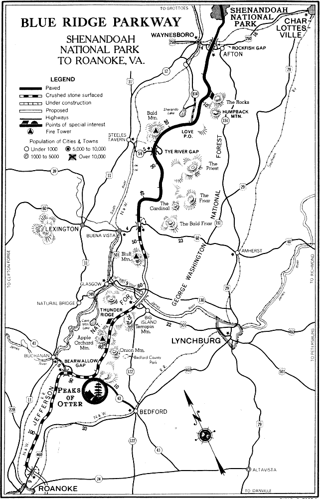
BLUE RIDGE PARKWAY SHENANDOAH NATIONAL PARK TO ROANOKE, VA. PKY-B. R. 7005-1
10