BLUE RIDGE PARKWAY Roanoke, Va.—North Carolina State Line
Reading edition
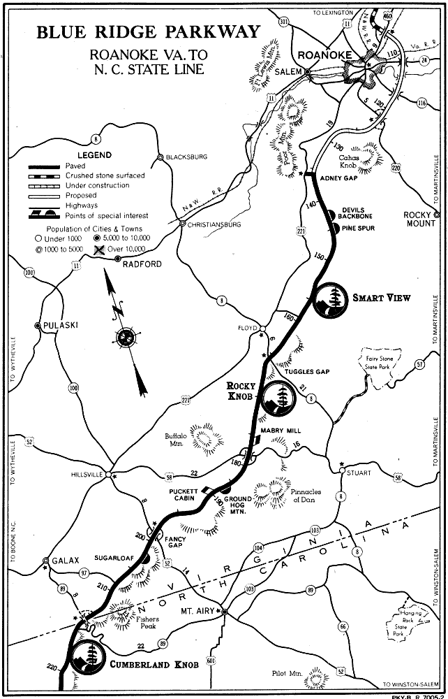
From Adney Gap (19 miles south of Roanoke by way of U S 221) the Parkway is paved south to the State Line and beyond to Deep Gap near Boone and Blowing Rock. This section of Parkway through lower Virginia is notable for its pictures of mountain farming. The Blue Ridge here is a high rolling plateau which breaks in a sharp escarpment toward the east and the lower Piedmont. The Parkway generally follows the crest, which is the water divide between Atlantic and Gulf drainage, affording occasional fine views over the low country. In other places the Parkway recedes into wooded and pastoral valleys of quiet charm.
Mile Post Elevation
136 Adney Gap. Terminus 140 mile paved section to Deep Gap, N. C. 2,690
144 Devil’s Backbone Parking Overlook. Fine view over farming region. 2,685
144.8 Pine Spur Parking Overlook. Named for the white pine which is the tree depicted on Parkway emblem. 2,703
150 Magnificent flame azalea; blooms mid-May.
154.5 Smart View, 500 acres, hiking trails, large picnic grounds, comfort stations, drinking water. The cabin home of T. T. Trail, immediately adjacent entrance road, is picturesque. Rim trail in this area is part of Appalachian Trail system. Smart View is center of Parkway’s dogwood bloom in early May. 2,500

164 Fine azalea show. Also mountain-laurel in late May.
165.2 Tuggles Gap. VA-8, turn-off for Fairy Stone State Park 16 miles. Swimming, boating, picnicking. 2,752
167 to 170 Rocky Knob, 4,000 acres. Picnicking, camping, trailer sites, hiking, comfort stations, drinking water, fishing 5 miles of Rock Castle Creek. Foot trail from Saddle Parking Overlook (Mile 168) to summit of Rocky Knob (El. 3,570) takes 10 minutes, continues along rim to Grassy Knoll (Mile 170). Fine for flame azalea late in May. 3,225
176.1 Mabry Mill, grist and sawmill, wheelwright and blacksmith shops, illustrating typical mountain “industrial plant,” fascinating and ingenious. Buildings will later be opened for inspection. 2,855
177.7 Meadows of Dan. U S 58 longest east-west road across Virginia. Inquire locally about Lovers Leap and the Pinnacles of Dan. 2,964
189.2 Groundhog Mountain Parking Overlook, high point affording 360° view. Observation tower, simulating old tobacco barn. Examples of various types of old chestnut rail fences, such as snake, post and rail, and buck. 3,030
189.9 Puckett Cabin, home of Arlena Hawks Puckett, storied midwife of the local hills. 2,850
199.5 Fancy Gap. U S 52, where local products, such as cabbage, are gathered to be trucked down the mountains. 2,920
11
BLUE RIDGE PARKWAY ROANOKE VA. TO N. C. STATE LINE PKY-B. R. 7005-2
12