BLUE RIDGE PARKWAY Linville River—Great Smoky Mountains National Park
Reading edition
The Parkway between Linville Falls and Asheville traverses one of the great mountain sections of North Carolina where the Blue Ridge, the Blacks, and the Craggy Mountains merge. Mount Mitchell, 6,684 feet in elevation, and the highest peak in the East, is prominent from the Parkway. The large holdings of the Mitchell Division of the Forest Service and the Asheville Watershed have protected the area from despoliation.
Mile Post Elevation
320.7 Chestoa View offers an unusually fine view from one of the many vertical cliffs on Humpback Mountain. 4,110
339.5 Crabtree Meadows, 160 acres lying within the Pisgah National Forest and now partially developed. Hiking, picnicking, and comfort stations available. The 40-minute walk to Crabtree Falls is not to be missed. 3,735

355.4 Swannanoa Gap, Mount Mitchell State Park. 4.8 miles on spur road. South to Mile Post 367.5 the Parkway is under contract to be completed early in summer of 1949 when this spectacular section will be opened to traffic. Make local inquiry. Paving of the Parkway through the Craggy Mountains is scheduled for 1950, and over the crushed stone surface special care in driving should be exercised. 5,185
367.5 Bee Tree Gap, turn off for Craggy Rhododendron Gardens. Forest Service development. The peak of the rhododendron bloom is in mid-June. Make inquiries in Asheville for highway connection to Parkway from the city. ASHEVILLE, a leading city in the South. Population, 50,000. 4,769
407 Mount Pisgah. The Forest Service Pisgah motor road, Cutthroat Gap to Wagon Road Gap, is still open, and 5 miles of Parkway, graded with loose gravel, extend beyond Wagon Road Gap and are available for a “preview.”
468 The Great Smoky Mountains National Park, where the Parkway will one day terminate, is located equally in North Carolina and Tennessee. Its 460,000 acres of mountainous wilds may be viewed from paved roads and many wilderness trails. Tourist accommodations are in nearby towns. Inquire Superintendent, Great Smoky Mountains National Park, Gatlinburg, Tenn.
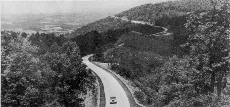
Parkway through Devils Garden, North Carolina.
15
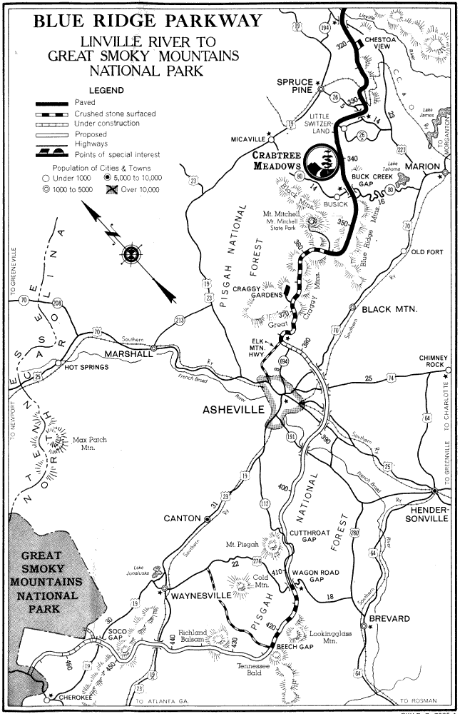
BLUE RIDGE PARKWAY LINVILLE RIVER TO GREAT SMOKY MOUNTAINS NATIONAL PARK PKY-B. R. 7005-4
16
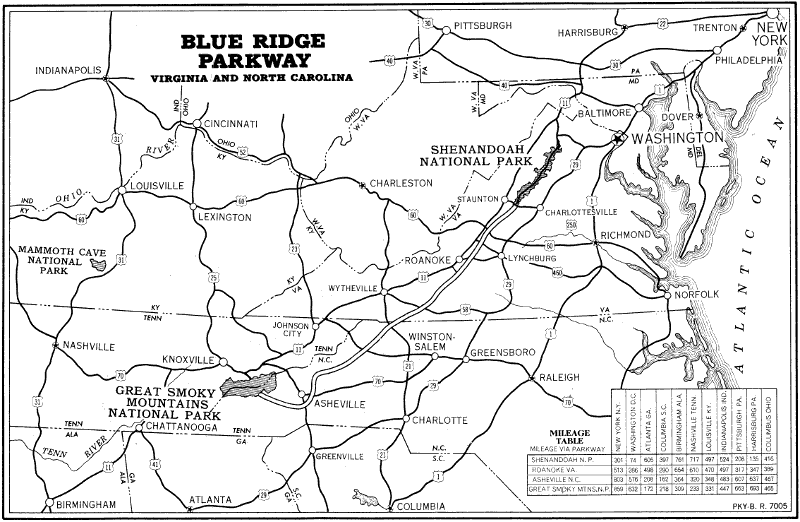
BLUE RIDGE PARKWAY VIRGINIA AND NORTH CAROLINA PKY-B. R. 7005
MILEAGE TABLE
MILEAGE VIA PARKWAY
SHENANDOAH N.P. ROANOKE VA. ASHEVILLE N.C. GREAT SMOKY MTNS. N.P.
NEW YORK N.Y. 301 513 803 859
WASHINGTON D.C. 74 286 576 632
ATLANTA GA. 605 498 208 172
COLUMBIA S.C. 397 290 162 218
BIRMINGHAM ALA. 761 654 364 309
NASHVILLE TENN. 717 610 320 233
LOUISVILLE KY. 497 470 348 331
INDIANAPOLIS IND. 524 497 483 447
PITTSBURGH PA. 208 317 607 663
HARRISBURG PA. 135 347 637 693
COLUMBUS OHIO 416 389 467 465
Revised 1949 U. S. GOVERNMENT PRINTING OFFICE: 1949 D-F—827633
UNITED STATES DEPARTMENT OF THE INTERIOR NATIONAL PARK SERVICE Great Smoky Mountains National Park North Caroline—Tennessee
THE APPALACHIAN TRAIL IN THE GREAT SMOKY MOUNTAINS NATIONAL PARK
The Appalachian Trail follows the North Carolina-Tennessee State Line, along the crest of the Smokies, for a total distance of approximately 70 miles in this park, from its eastern terminus at Davenport Gap to its Western terminus at Deals Gap. The trans-mountain highway (Tenn. No. 71, N. C. No. 107) intersects this trail at its approximate half-way point at Newfound Gap.
The eastern section of the trail is a graded four-foot standard horse trail. The western section is an ungraded, brushed-out, foot trail, rather rough in places. It is marked with white blazes on trees; across the mountain meadows (“balds”) prominent boulders are marked with white paint.
A new cut-off trail has been marked and brushed out leaving the state line near Doe Knob and proceeding southward to Fontana Village by way of Twentymile Ridge, Sassafras Gap, and Shuckstack. This trail is very steep between Shuckstack and Fontana.
Trailside shelters are located at approximate nine-mile intervals along this trail, at Cosby Knob, Tri-Corner Knob, Hughes Ridge, Ice-Water Spring on Ft. Kephart, Little Indian Gap, Silers Bald, Spence Field, and Moore Spring on Gregory Bald. These shelters are log and pole frame, enclosed on three sides with one large opening on the front, long side. In each shelter is a bunk made of a wooden frame with heavy wire screen for the springs, raised off the ground about two feet; this should accommodate six persons. Each shelter has a fireplace, water supply, garbage pit, pit latrine, hitching rack, and watering trough for horses. There are no means for heating the shelters; a fireplace is located outside the roof line of the building.
In addition to these shelters, camping places along the trail have been designated at approximately nine-tenths mile from Davenport Gap, and at the Halls Cabin site between Silers Bald and Thunderhead, and at Sassafras Gap, just north of Shuckstack on the State Line-Fontana Village cut-off.
Camping or fire-building is permitted along this trail only at the trailside shelters and designated camping sites except when some unforeseen emergency may arise, and the stay at any one shelter is limited to one night only unless inclement weather prevents the resumption of the trip. A camping permit is required for camping along this trail. Such a permit may be obtained from any of the rangers or wardens or upon application to the office of the Superintendent, Great Smokey Mountains National Park, Gatlinburg, Tennessee.
Because of the scarcity of fuel at the shelters, hikers are advised to carry primus-type stoves.
All who use any park trail are urged to be extremely careful with fire and to completely extinguish all fires before leaving them. SMOKERS, BE CAREFUL!
LODGING AND CAMPING FACILITIES
There are no Government-operated cabins nor lodging accommodations in the Great Smoky Mountains National Park. Under the policy approved by the Secretary of the Interior, tourist facilities within the boundaries of this park are limited to automobile campgrounds and picnic areas. Cabins and lodging accommodations may be obtained in any of the towns surrounding the park, and such information may be obtained from the Chambers of Commerce of such cities. The only accommodations inside the park are LeConte Lodge on the summit of Mt. LeConte, accessible only by foot or horseback, and Wonderland Club Hotel, Elkmont, Tennessee. These are operated under permit from the National Park Service. Information regarding these may be obtained by writing direct to LeConte Lodge, Gatlinburg, Tennessee, and the Wonderland Club Hotel, Elkmont, Tennessee.
There are at present two permanent public campgrounds in the park—the Chimneys campground located about seven and a half miles from Gatlinburg, Tennessee, and the Smokemont campground located about four miles from the Oconaluftee Ranger Station in North Carolina. These campgrounds are furnished with water supply, fireplaces, tables and benches, comfort stations, and tent and trailer spaces. Campers must bring their own tent or trailer and other camping equipment.
There are also meagerly furnished temporary primitive campgrounds located in Cosby, Greenbrier, Elkmont, Walkers Valley, Cades Cove, Happy Valley, and Bunny Branch on the Tennessee side, and about the mouth of Lost Cove on Eagle Creek, at the old ball grounds at Proctor and at the confluence of Bone Valley and Hazel Creeks in Hazel Creek, at the head of the bay on Forney Creek and four miles up Forney Creek at the warden station, and on Noland Creek, and Deep Creek Straight Fork, Cataloochee, and Big Creek on the North Carolina side.
The campgrounds are open the year round, but during freezing weather the water is cut off and the comfort stations closed. Caretaker services are provided in the Chimneys and Smokemont campgrounds from about the middle of May until October. The campgrounds are operated on a first-come-first-served basis and reservations are not taken for camping space.
No special permit is required for camping at any of the designated campgrounds in the park, but a camping permit is required for camping elsewhere in the park. Such a permit may be obtained from any of the rangers or wardens or upon application to the office of the Superintendent, Great Smoky Mountains National Park, Gatlinburg, Tennessee.