PART III. APPENDIX I. & II. CONTAINING SUPPLEMENTARY ACCOUNTS OF THE RUSSIAN DISCOVERIES, &c. &c.
Reading edition
Krenitzin's and Levasheff's Voyage to the Fox Islands in 1768 and 1769.
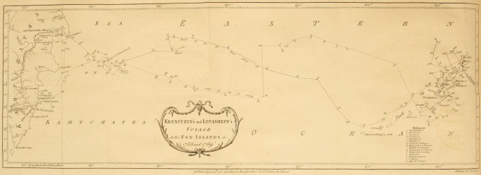
APPENDIX I. Extract from the journal of a voyage made by Captain Krenitzin and Lieutenant Levasheff to the Fox Islands, in 1768, 1769, by order of the Empress of Russia—they sail from Kamtchatka—arrive at Beering's and Copper Islands—reach the Fox Islands—Krenitzin winters at Alaxa—Levasheff upon Unalashka—productions of Unalashka—description of the inhabitants of the Fox Islands—their manners and customs, &c.
Krenitzin and Levasheff sail from the Mouth of the Kamtchatka River, 1768.
On the 23d of July Captain Krenitzin sailed in the Galliot St. Catherine from the mouth of the Kamtchatka river towards America: he was accompanied by Lieutenant Levasheff, in the Hooker St. Paul. Their instructions were regulated by information derived from Beering's expedition in 1741. Shaping their course accordingly, they found themselves more to the North than they expected; and were told by the Russian traders and hunters, that a similar[121] mistake was committed in the chart of that expedition. These traders, who for some years past were accustomed to ramble to the distant islands in quest of furs, said that they were situated much more to the South, and farther East than was imagined. |They reach Beering's Island.| On the 27th they saw Commodore's or Beering's Island, which is low and rocky, especially to the S. W. On this side they observed a small harbour, distinguished by two hillocks like boats, and not far from it they found a fresh water lake.
and Copper Island.
To the S. E. lies another island, called by the Russians Mednoi Ostroff, or Copper Island, from a great quantity of copper found upon its N. E. coast, the only side which is known to the Russians. It is washed up by the sea, and covers the shore in such abundance, that many ships may load with it. Perhaps an India trader might make a profitable voyage from thence to China, where this metal is in high demand. This copper is mostly in a metallic or malleable state, and many pieces seem as if they had formerly been in fusion. The island is not high, but has many hillocks, each of which has the appearance of having formerly been the funnel of a volcano. We may here, once for all, observe, that all the islands represented in this chart[122] abound with such funnels, called in Russian Sopka, in so much that no island, however small, was found without one; and many of them consisted of nothing else. In short, the chain of islands here laid down may, without any violent stretch of imagination, be considered as thrown up by some late volcanos. The apparent novelty of every thing seems to justify this conjecture: nor can any objection be derived from the vegetable productions with which these islands abound; for the summer after the lower district of Zutphen in Holland was gained from the sea, it was covered over with wild mustard. All these lands are subject to violent and frequent earth-quakes, and abound in sulphur. The writer of the journal was not able to inform us whether any lava was found upon them; but he speaks of a party-coloured stone as heavy as iron. From this account it is by no means improbable, that the copper abovementioned has been melted in some eruption.
Arrive at the Fox Islands.
After leaving Copper Island, no land was seen from either of the ships (which had parted company in a fog) till on the S. E. quarter of their tract, was discovered the chain of islands or head-lands laid down in the chart. These in general appeared low, the shore bad, without creeks, and the water between them very shallow. During their course outwards, as well as during their return, they had frequent fogs. It appears from the journal, as well as from the relation of the hunters, that it is very uncommon to have clear weather for five days together, even during summer.
Krenitzin winters at Alaxa.
The St. Catherine wintered in the straits of Alaxa, where they hauled her into shoal water. The instructions given to the captain set forth, that a private ship had in 1762 found there a commodious haven; but he looked for it in vain. The entrance of this strait from the N. E. was extremely difficult on account of flats, and strong currents both flood and ebb: the entrance however from the S. E. was afterwards found to be much easier with not less than 5-1/2 fathoms water. Upon surveying this strait, and the coast of Alaxa, many funnels were observed in the low grounds close to the shore, and the soil produced few plants. May not this allow one to suppose that the coast had suffered considerable changes since the year 1762? Few of the islands produce wood, and that only in the vallies by the rivulets. Unalga and Alaxa contain the most; they abound with fresh water streams, and even rivers; from which we may infer that they are extensive. The soil is in general boggy, and covered with moss; but Alaxa has more soil and produces much grass.
Levasheff winters upon Unalashka.
The St. Paul wintered in Unalashka. This wintering place was observed to lie in 53° 29´ North latitude, and its longitude from the mouth of Kamtchatka river, computed by the ship's journal, was 27° 05´ East[123]. Unalashka is about fifty miles long from N. E. to S. W. and has on the N. E. side three bays. One of them called Udagha stretches thirty miles E. N. E. and W. S. W. nearly through the middle of the island. Another called Igunck, lying N. N. E. and S. S. W. is a pretty good harbour, with three and a half fathom water at high tide, and sandy ground. It is well sheltered from the North swell at its entrance by rocks, some of which are under water. The tide flows here five feet at full and change, and the shore is in general bold and rocky, except in the bay, at the mouth of a small river. There are two burning mountains on this island, one called Ayaghish, and the other (by the Russians) the Roaring Mountain. Near the former is a very copious hot spring. The land is in general rocky, with loamy and clayey grounds; but the grass is extremely coarse, and unfit for pasture. Hardly any wood is to be found on it. |Productions of Unalashka.| Its plants are dwarf cherry ([124]Xylosteum of Tournefort), wortle berry, (Vaccinium Uliginosum of Linnæus), rasberry, farana and shikshu of Kamtchatka and kutage, larch, white poplar, pine and birch[125]. The land animals are foxes of different colours, mice, and weasels; there are also beavers[126], sea cats, and sea lions as at Kamtchatka. Among their fish we may reckon cod, perch, pilchards, smelts, roach, needle fish, terpugh, and tchavitcha. The birds are eagles, partridges, ducks, teals, urili, ari, and gadi. The animals for whose Russian names I can find no translations, are (excepting the Ari) described in Krashininikoff's History of Kamtchatka, or in Steller's relation contained in the second volume of the Memoirs of the Academy of Petersburgh.
Account of the Inhabitants of the Fox Islands.
The inhabitants of Alaxa, Umnak, Unalaksha, and the neighbouring islands, are of a middle stature, tawny brown colour, and black hair. In summer they wear coats (parki[127]) made of bird skins, over which, in bad weather, and in their boats, they throw cloaks, called kamli, made of thin whale guts. On their heads they wear wooden caps, ornamented with duck's feathers, and the ears of the sea-animal, called Scivutcha or sea-lion; they also adorn these caps with beads of different colours, and with little figures of bone or stone. In the partition of the nostrils they place a pin, about four inches long, made of the bone, or of the stalk of a certain black plant; from the ends of this pin or bodkin they hang, in fine weather and on festivals, rows of beads, one below the other. They thrust beads, and bits of pebble cut like teeth, into holes made in the under-lips. They also wear strings of beads in their ears, with bits of amber, which the inhabitants of the other islands procure from Alaxa, in exchange for arrows and kamli.
They cut their hair before just above the eyes, and some shave the top of their heads like monks. Behind the hair is loose. The dress of the women hardly differs from that of the men, excepting that it is made of fish-skins. They sew with bone needles, and thread made of fish guts, fastening their work to the ground before them with bodkins. They go with the head uncovered, and the hair cut like that of the men before, but tied up behind in a high knot. They paint their cheeks with strokes of blue and red, and wear nose-pins, beads, and ear-rings like the men; they hang beads round their neck, and checkered strings round their arms and legs.
Manners and Customs.
In their persons we should reckon them extremely nasty. They eat the vermin with which their bodies are covered, and swallow the mucus from the nose. Having washed themselves, according to custom, first with urine, and then with water, they suck their hands dry. When they are sick, they lie three or four days without food; and if bleeding is necessary, they open a vein with lancets made of flint, and suck the blood.
Their principal nourishment is fish and whale fat, which they commonly eat raw. They also feed upon sea-wrack and roots, particularly the saran, a species of lily; they eat a herb, called kutage, on account of its bitterness, only with fish or fat. They sometimes kindle fire by catching a spark among dry leaves and powder of sulphur: but the most common method is by rubbing two pieces of wood together, in the manner practised at Kamtchatka[128], and which Vaksel, Beering's lieutenant, found to be in use in that part of North America which he saw in 1741. They are very fond of Russian oil and butter, but not of bread. They could not be prevailed upon to taste any sugar until the commander shewed the example; finding it sweet, they put it up to carry it home to their wives.
The houses of these islanders are huts built precisely in the manner of those in Kamtchatka, with the entry through a hole in the middle of the roof. In one of these huts live several families, to the amount of thirty or forty persons. They keep themselves warm by means of whale fat burnt in shells, which they place between their legs. The women set apart from the men.
Six or seven of these huts or yourts make a village, of which there are sixteen in Unalashka. The islands seem in general to be well inhabited, as may be conjectured from the great number of boats which are seen continually plying along the shore. There are upwards of a thousand inhabitants on Unalashka, and they say that it was formerly much more populous. They have suffered greatly by their disputes with the Russians, and by a famine in the year 1762; but most of all from a change in their way of life. No longer contented with their original simplicity, they long for Russian luxuries: in order therefore to obtain a few delicacies, which are presently consumed, they dedicate the greatest part of their time to hunting, for the purpose of procuring furs for the Russians: by these means, they neglect to lay up a provision of fish and roots; and suffer their children frequently to die of hunger.
Their principal food is fish, which they catch with bone hooks. Their boats, in which they row to a great distance from land, are made, like those of the Innuet or Esquimaux, of thin slips of wood and skins: these skins cover the top as well as the sides of the boat, and are drawn tight round the waist of the rower. The oar is a paddle, broad at both ends. Some of their boats hold two persons; one of whom rows, and the other fishes: but these kind of boats seem appropriated to their chiefs. They have also large boats capable of holding forty men. They kill birds and beasts with darts made of bone, or of wood tipped with sharpened stone: they use these kind of darts in war, which break with the blow given by them, and leave the point in the wound.
The manners and character of these people are what we should expect from their necessitous situation, extremely rude and savage. The inhabitants however of Unalashka are somewhat less barbarous in their manners and behaviour to each other, and also more civil to strangers than the natives of the other islands; but even they are engaged in frequent and bloody quarrels, and commit murder without the least compunction. Their disposition engages them in continual wars, in which they always endeavour to gain their point by stratagem. The inhabitants of Unimak are formidable to all the rest; they frequently invade the other islands, and carry off women, the chief object of their wars. Alaxa is most subject to these incursions, probably because it is more populous and extensive. They all join in hating the Russians, whom they consider as general invaders, and therefore kill them wherever they can. The people of Unalashka however are more friendly; for Lieutenant Levasheff, being informed that there was a Russian vessel in the straits of Alaxa, prevailed on some Unalashkans to carry a letter, which they undertook, notwithstanding the danger they were exposed to from the inhabitants of the intervening islands.
The journalist says, that these people have no kind of religion, nor any notion of a God. We observe however among them sufficient marks of such a religion as might be expected from people in their situation. For the journalist informs us, that they have fortune-tellers employed by them at their festivals. These persons pretend to foretel events by the information of the Kugans or Dæmons. In their divinations they put on wooden masks, made in the form in which they say the Kugan appeared to them; they then dance with violent motions, beating at the same time drums covered with fish skins. The inhabitants also wear little figures on their caps, and place others round their huts, to keep off the devils. These are sufficient marks of a savage religion.
It is common for them to have two, three, or four wives, and some have also an object of unnatural affection, who is dressed like the women. The wives do not all live together, but, like the Kamtchadals, in different yourts. It is not unusual for the men to exchange their wives, and even sell them, in time of dearth, for a bladder of fat; the husband afterwards endeavours to get back his wife, if she is a favourite, and if unsuccessful he sometimes kills himself. When strangers arrive at a village, it is always customary for the women to go out to meet them, while the men remain at home: this is considered as a pledge of friendship and security. When a man dies in the hut belonging to his wife, she retires into a dark hole, where she remains forty days. The husband pays the same compliment to his favourite wife upon her death. When both parents die, the children are left to shift for themselves. The Russians found many in this situation, and some were brought for sale.
In each village there is a sort of chief, called Tookoo, who is not distinguished by any particular rank or authority. He decides differences by arbitration, and the neighbours enforce the sentence. When he goes out to sea he is exempted from working, and has a servant, called Kalè, for the purpose of rowing the canoe; this is the only mark of his dignity: at all other times he labours like the rest. The office is not hereditary; but is generally conferred on him who is most remarkable for his personal qualities; or who possesses a great influence by the number of his friends. Hence it frequently happens, that the person who has the largest family is chosen.
During their festivals, which are held after the fishing season ends in April, the men and women sing songs; the women dance, sometimes singly, and sometimes in pairs, waving in their hands blown bladders; they begin with gentle movements, which become at last extremely violent.
The inhabitants of Unalashka are called Kogholaghi. Those of Akutan, and farther East to Unimak, are called Kighigusi; and those of Unimak and Alaxa are called Kataghayekiki. They cannot tell whence they have these names, and now begin to call themselves by the general name of Aleyut, given them by the Russians, and borrowed from some of the[129]Kuril islands. Upon being asked concerning their origin, they said that they had always inhabited these islands, and knew nothing of any other country beyond them. All that could be gathered from them was, that the greatest numbers came from Alaxa, and that they did not know whether that land had any bounds. The Russians surveyed this island very far to the N. E. in boats, being out about a fortnight, and set up a cross at the end of their survey. The boats of the islanders are like those of the Americans. It appears however from their customs and way of life, so far as these are not necessarily prescribed to them by their situation, that they are of Kamtchatdal original. Their huts, their manner of kindling fire, and their objects of unnatural affections, lead to this conjecture. Add to this, the almost continual Westerly winds, which must render the passage Westward extremely difficult. Beering and Tchirikoff could never obtain Easterly winds but by going to the Southward.
The Russians have for some years past been accustomed to go to these islands in quest of furs, of which they have imposed a tax on the inhabitants. The manner of carrying on this trade is as follows. The Russian traders go in Autumn to Beering's and Copper island, and there winter: they then employ themselves in catching the sea-cat, and afterwards the Scivutcha, or sea-lion. The flesh of the latter is prepared for food, and it is very delicate. They carry the skins of these sea-animals to the Eastern islands. Next summer they go Eastward, to the Fox-islands; and again lay their ships up for the winter. They then endeavour to procure, either by persuasion or force, the children of the inhabitants, particularly of the Tookoos, as hostages. This being accomplished, they deliver to the inhabitants fox-traps, and also skins for their boats, for which they oblige them to bring furs and provisions during the winter. After obtaining from them a certain quantity of furs, by way of tax, for which they give them quittances; the Russians pay for the rest in beads, false pearls, goat's wool, copper kettles, hatchets, &c. In the spring they get back their traps, and deliver up their hostages. They dare not hunt alone, nor in small numbers, on account of the hatred of the natives. These people could not, for some time, comprehend for what purpose the Russians imposed a tribute of skins, which were not to be their own property, but belonged to an absent person; for their Tookoos have no revenue. Nor could they be made to believe, that there were any more Russians than those who came among them; for in their own country all the men of an island go out together. At present they comprehend something of Kamtchatka, by means of the Kamtchadals and Koriacs who come along with the Russians; and on their arrival love to associate with people whose manner of life resembles their own.
Krenitzin and Levasheff returned from this expedition into the mouth of the Kamtchatka river in autumn 1769.
The chart which accompanies this journal was composed by the pilot Jacob Yakoff, under the inspection of the commanders[130] Krenitzin and Levasheff. The track of the St. Paul is marked both in going out and returning. The harbour of the St. Paul in the island Unalashka, and the straits of Alaxa, are laid down from observations made during the winter 1768; and the islands connected by bearings and distances taken during a cruise of the St. Paul twice repeated.
In this chart the variation is said to be
InLat.Long.Points
54°40´.204.2 East.
52202011-1/2
52501981-1/2
5320192301
53401881
5450182300-3/4
5500180300-3/4
No II. Concerning the longitude of Kamtchatka, and of the Eastern extremity of Asia, as laid down by the Russian Geographers.
Longitude of the extreme Parts of Asia.
The important question concerning the longitude of the extreme parts of Asia has been so differently stated by the most celebrated geographers, that it may not be amiss to refer the curious reader to the principal treatises upon that subject. |by Mr. Muller and the Russian Geographers.| The proofs by which Mr. Muller and the Russian geographers place the longitude of the Eastern extremity of Asia beyond 200 degrees from the first meridian of Fero, or 180° 6´ 15´´ from Paris, are drawn from the observations of the satellites of Jupiter, made by Krassilnikoff at Kamtchatka, and in different parts of Siberia, and from the expeditions of the Russians by land and sea towards Tschukotskoi Noss.
by Mr. Engel.
Mr. Engel calls in question the exactness of these observations, and takes off twenty-nine degrees from the longitude of Kamtchatka, as laid down by the Russians. To this purpose he has given to the public,
1. Memoires et observations geographiques et critiques sur la situation des Pays Septentrionaux de l'Asie et de l'Amerique. A Lausanne, 1765.
2. Geographische und Critische Nachricht ueber die Lage der noerdlichen Gegenden von Asien und America. Mittau, 1772.
by Mr. Vaugondy.
It appears to Monsieur de Vaugondy, that there are not sufficient grounds for so extraordinary a diminution: accordingly he shortens the continent of Asia only eleven degrees of longitude; and upon this subject he has given the two following treatises:
1. Lettre au sujet d'une carte systematique des Pays Septentrionaux de l'Asie et de l'Amerique. Paris, 1768.
2. Nouveau systeme geographique, par lequel on concilie les anciennes connoissances sur les Pays au Nord Ouest de l'Amerique. Paris, 1774.
Mons. Buache supports the System of the Russians against Engel and Vaugondy.
In opposition to these authors, Monsieur Buache has published an excellent treatise, entitled Memoires sur les Pays de l'Asie et de l'Amerique. Paris, 1775.
In this memoir he dissents from the opinions of Messrs Engel and Vaugondy; and defends the system of the Russian geographers in the following manner. Monsieur Maraldi, after comparing the observations of the satellites of Jupiter, taken at Kamtchatka by Krassilnikoff, with the tables, has determined the longitude of Ochotsk, Bolcheresk, and the port of St. Peter and Paul from the first meridian of Paris as follows:
h´´´
[131]Longitude of Ochotsk 9 23 30
of Bolcheresk 10 17 17
of the Port 10 25 5
Latitude of Ochotsk 59° 22´, of Bolcheresk 52° 55´, of the Port 53° 1´.
The comparison of the following results, deduced from corresponding observations[132] of the eclipses of Jupiter's satellites taken at Bolcheresk at the port of Peter and Paul by Krassilnikoff, and at Pekin by the Jesuit missionaries, will shew from their near agreement the care and attention which must have been given to the observations; and from hence there is reason to suppose, that the suspicions of inaccuracy imputed to Krassilnikoff are ill founded.
1741, Old Stile.
h´´´
Jan. 27, Em. I Sat. 12 9 25 at the port of St. Peter and Paul
9 20 35 at Pekin.
Difference of the meridian at Pekin and the Port 2 48 50
h´´´
Jan. 30, Imm. III Sat. 12 5 30 at the Port.
9 16 30 at Pekin.
2 49 0
h´´´
Feb. 5, I Sat. 8 33 26 at the Port.
5 43 45 at Pekin.
2 49 41
h´´´
Feb. 12, Em. I Sat. 10 28 49
7 39 29
2 49 20
And the longitude from Paris to Pekin being 7 36 23
The difference of the meridians of Paris and the Port will be 10 25 36
Which differs only 31 seconds from the determination of Mr. Maraldi.
1741. Old Style.
h´´´
March 23, Em. II Sat. 10 55 2 at Bolcheresk.
8 14 0 at Pekin.
2 41 2
h´´´
Dec. 31, Im. I Sat. 10 51 58 at Bolcheresk.
8 9 45 at Pekin.
Difference of the meridians of Pekin and Bolcheresk 2 42 13
h´´´
By taking the medium the difference of the longitude between Bolcheresk and Pekin will be found to be 2 41 37
Between Bolcheresk and Paris 10 18 0
Which differs only one minute and one second from the determination of Mr. Maraldi.
In order to call in question the conclusions drawn from the observations of Krassilnikoff, Monsieur de Vaugondy pretends that the instruments and pendulums, which he made use of at Kamtchatka, were much damaged by the length of the journey; and that the person who was sent to repair them was an unskilful workman. But this opinion seems to have been advanced without sufficient foundation. Indeed Krassilnikoff[133] himself allows that his pendulum occasionally stopt, even when necessary to ascertain the true time of the observation. He admits therefore that the observations which he took under these disadvantages (when he could not correct them by preceding or subsequent observations of the sun or stars) are not to be depended upon, and has accordingly distinguished them by an asterisk; there are however a number of others, which were not liable to any exception of this kind; and the observations already mentioned in this number are comprised under this class.
If the arguments which have been already produced should not appear sufficiently satisfactory, we have the further testimony of Mr. Muller, who was in those parts at the same time with Krassilnikoff, and who is the only competent judge of this matter now alive. For that respectable author has given me the most positive assurances, that the instruments were not damaged in such a manner as to effect the accuracy of the observations when in the hands of a skilful observer.
Accuracy of the Russian Geographers.
That the longitude of Kamtchatka is laid down with sufficient accuracy by the Russian geographers, will appear by comparing it with the longitude of Yakutsk; for as the latter has been clearly established by a variety of observations, taken at different times and by different persons, if there is any error in placing Kamtchatka so far to the East, it will be found in the longitude between Yakutsk and Bolcheresk. A short comparison therefore of some of the different observations made at Yakutsk will help to settle the longitude of Kamtchatka, and will still farther confirm the character of a skilful observer, which has been given to Krassilnikoff.
Krassilnikoff in returning from Kamtchatka observed at Yakutsk several eclipses of the satellites of Jupiter, of which the following are mentioned by him as the most exact.
1744, Old Style.
h´´´
[134]Feb. 7. Imm. I. Sat. 11 18 35 somewhat doubtful.
22. Imm. II. Sat. 10 31 11 } all exact.
29. Imm. II. Sat. 13 6 54
Mar. 1. Imm. I. Sat. 11 23 0
Apr. 9. Em. I. Sat. 12 23 50
The same eclipses, as calculated by the tables of Mr. Wargentin, for the meridian of Paris, are as follow:
h´´´ h´´´
Feb. 7. Imm. I. 2 49 0 Difference of 8 29 35
27. Imm. I. 12 3 10 the meridian 8 21 1
29. Imm. II. 4 38 17 of Paris— 8 28 37
Mar. 1. Imm. I. 3 3 37 and Yakutsk 8 29 23
Apr. 9. Em. I. 3 54 12 8 29 46
The mean of which is 8 29 5
The observations of Mr. Islenieff[135], made at Yakutsk in the year 1769, to which place he was sent to observe the transit of Venus, have received the sanction of the Imperial Academy. The longitude which he fixes for Yakutsk is 8h 29´ 34´´. this corresponds, to a sufficient degree of exactness, with the longitude inferred from, the observations of Krassilnikoff.
Thus the longitude of Yakutsk from Paris being 8h 29° 4´´. or in degrees 127 16 0. and of Bolcheresk 10 17 17, or in degrees 150° 19´ 15. the difference of the longitude of these two places, from astronomical observations, amounts to 1 48 8. or in degrees 27° 3´ 0. The latitude of Bolcheresk is 52° 55´ 0´´. and that of Yakutsk 62° 1´ 50´´. and the difference of their longitudes being from the preceding determination 27 3 0. the direct distance between the places measured on a great circle of the earth will appear by trigonometry to be 16° 57´. or about 1773 versts reckoning 104-1/2 versts to a degree. This distance consists partly of sea, and partly of land; and a constant intercourse is kept up between the two places, by means of Ochotsk, which lies between them. The distance by sea from Bolcheresk to Ochotsk is estimated by ships reckonings to be 1254 versts, and the distance by land from Ochotsk to Yakutsk is 927 versts, making altogether 2181. The direct distance deduced by trigonometry, (on a supposition that the difference of longitude between Bolcheresk and Yakutsk is 27° 3´.) is 1773, falling short of 2181 by 408. a difference naturally to be expected from considering, that neither roads by land, or the course of ships at sea, are ever performed precisely on a great circle of the earth, which is the shortest line that can be drawn on the earth's surface between two places.
By this agreement between the distance thus estimated, and that deduced by computation, on supposing the difference of longitude between Yakutsk and Bolcheresk to be 27° 3´. it seems very improbable, that there should be an error of many degrees in the astronomical determination.
Since then the longitude between Fero and Petersburgh is acknowledged to be 48°—that between Petersburgh and Yakutsk 99° 21´—and as the distance in longitude between Yakutsk and Bolcheresk cannot be materially less than 27° 3´. it follows that the longitude of Bolcheresk from Fero cannot be much less than 174° 24´. Where then shall we find place for so great an error as 27 degrees, which, according to Mr. Engel, or even of 11°. which, according to Mons. Vaugondy, is imputed to the Russian geographers, in fixing the longitude of Kamtchatka?
From the isle of Fero
Longitude of Yakutsk 147 0 0
of Ochotsk 160 7 0
of Bolcheresk 174 13 0
of the Port of St. Peter and Paul 176 10 0
Longitude of the extreme parts of Asia determined by the Russians.
As no astronomical observations have been made further to the East than the Port of St. Peter and Paul, it is impossible to fix, with any degree of certainty, the longitude of the North-Eastern promontory of Asia. It appears however from Beering's and Synd's coasting voyages towards Tschukotskoi Noss, and from other expeditions to the parts by land and sea, that the coast of Asia in lat. 64. stretches at least 23° 2 30. from the Port, or to about 200° longitude from the Isle of Fero.
No III. Summary of the proofs tending to shew, that Beering and Tschirikoff either reached America in 1741, or came very near it.
The coast which Beering reached, and called Cape St. Elias, lay, according to his estimation, in 58°. 28´. N. latitude, and in longitude 236°. from Fero: the coast touched at by Tschirikoff was situated in lat. 56°. long. 241°[136].
Arguments advanced by Steller to prove that Beering and Tschirikoff discovered America.
Steller, who accompanied Beering in his expedition towards America, endeavours to prove, that they discovered that continent by the following arguments[137]: The coasts were bold, presenting continued chains of high mountains, some of which were so elevated, that their tops were covered with snow, their sides were cloathed from the bottom to the top with large tracts of thick and fine wood[138].
Steller went ashore, where he remained only a few hours; during which time he observed several species of birds which are not known in Siberia: amongst these was the bird described by[139]Catesby, under the name of Blue Jay; and which has never yet been found in any country but North America. The soil was very different from that of the neighbouring islands, and at Kamtchatka: and he collected several plants, which are deemed by botanists peculiar to America.
The following list of these plants was communicated to me by Mr. Pallas: I insert them however without presuming to decide, whether they are the exclusive growth of North America: the determination of this point is the province of botany.
Trillium Erectum. Fumaria Cucullaria. A species of Dracontium, with leaves like the Canna Indica. Uvularia Perfoliata. Heuchera Americana. Mimulus Luteus, a Peruvian plant. A species of Rubus, probably a variety of the Rubus Idæus, but with larger berries, and a large laciniated red calyx.
None of these plants are found in Kamtchatka, or in any of the neighbouring islands[140].
Though these circumstances should not be considered as affording decisive proofs, that Beering reached America; yet they will surely be admitted as strong presumptions, that he very nearly approached that continent[141].
No IV. List of the principal charts representing the Russian discoveries.
The following is an authentic list of the principal charts of the Russian discoveries hitherto published. It is accompanied with a few explanatory remarks.
List of the Charts of the Russian Discoveries
1. Carte des nouvelles dècouvertes au nord de la mer du sud, tant à l'Est de la Siberie et du Kamtchatka, qu'à l'Ouest de la Nouvelle France dressé sur les memoires de Mr. de l'Isle, par Philippe Buache, 1750. A memoir relative to this chart was soon afterwards published, with the following title, Explication de la carte des nouvelles dècouvertes au Nord de la mer du sud par Mr. de l'Isle Paris, 1752, 4to.
This map is alluded to, p. 26 of this work.
2. Carte des nouvelles dècouvertes entre la partie orientale de l'Asie et l'Occidentale de l'Amerique, avec des vues sur la grande terre réconnue, par les Russes, en 1741, par Phil. Buache, 1752.
3. Nouvelle carte des dècouvertes faites par des vaisseaux Russiens aux cotés inconnus de l'Amerique septentrionale avec les pais adjacens, dressés sur les memoires authentiques de ceux qui ont assisté à ces dècouvertes, et sur d'autres connoissances; dont on rend raison dans un memoire separé: à St. Petersburg, à l'Academie Imperiale des Sciences, 1754. 1758.
This map was published under the inspection of Mr. Muller, and is still prefixed to his account of the Russian discoveries[142]. The part which exhibits the new discovered isles and the coast of America, was chiefly taken from the chart of Beering's expedition. Accordingly that continent is represented as advancing, between 50 and 60 degrees of latitude, to within a small distance of Kamtchatka. Nor could there be any reason to suspect, that such experienced sailors as Beering and Tschirikoff had mistaken a chain of islands for promontories belonging to America, until subsequent navigators had actually sailed through that very part, which was supposed to be a continent.
4. A second chart published by the Academy, but not under the inspection of Mr. Muller, bears the same title as the former.
Nouvelle carte des dècouvertes faites par des vaisseaux Russiens aut côtés inconnus de l'Amerique, &c. 1773.
It is for the most part a copy of a manuscript chart known in Russia by the name of the chart of the Promyshlenics, or merchant adventurers, and which was sketched from the mere reports of persons who had sailed to the New Discovered Islands. As to the size and position of the New Discovered Islands, this chart of the Academy is extremely erroneous: it is however free from the above-mentioned mistake, which runs through all the former charts, namely, the representing of the coast of America, between 50 and 60 degrees of latitude, as contiguous to Kamtchatka. It likewise removes that part of the same continent lying in latitude 66, from 210° longitude to 224°, and in its stead lays down a large island, which stretches between latitude 64° and 71° 30´, from 207° longitude to 218°, to within a small distance of both continents. But whether this latter alteration be equally justifiable or not, is a question, the decision of which must be left to future navigators[143].
5. Carte du nouvel Archipel du Nord decouvert parles Russes dans la mer de Kamtchatka et d'Anadir.
This chart is prefixed to Mr. Stæhlin's account of the New Northern Archipelago. In the English translation it is called, A Map of the New Northern Archipelago, discovered by the Russians in the seas of Kamtchatka and Anadyr. It differs from the last mentioned chart only in the size and position of a few of the islands, and in the addition of five or six new ones, and is equally incorrect. The New Discovered Islands are classed in this chart into three groups, which are called the Isles of Anadyr[144], the Olutorian[145] Isles, and the Aleütian Isles. The two last mentioned charts are alluded to, p. 26 of this work.
6. An excellent map of the Empire of Russia, published by the geographical department of the Academy of Sciences at St. Petersburg in 1776, comprehends the greatest part of the New Discovered Islands. A reduced copy of this chart being prefixed to this work, I shall only mention the authorities from whence the compilers have laid down the New Discovered Islands. The Aleütian Isles are partly taken from Beering's chart, partly from[146]Otcheredin's, whose voyage is related in the eleventh chapter, and partly from other MS. charts of different navigators. The islands near the coast of the Tschutski are copied from Synd's chart. The Fox Islands are laid down from the chart of Otcheredin. The reader will perceive, that the position of the Fox Islands, upon this general map of Russia, is materially different from that assigned to them in the chart of Krenitzin's and Levasheff's voyage. In the former they are represented as stretching between 56° 61´ North latitude, and 210° and 230° longitude from the isle of Fero: in the latter they are situated between 51° 40´ and 55° 20´ latitude, and 199° 30´ and 207° 30´ longitude. According to the most recent accounts received from Petersburg, the position given to them upon this general map is considerably too much to the North and East; consequently that assigned to them upon Krenitzin's chart is probably the most to be depended upon.
7. Carte des dècouvertes Russes dans la mer orientale et en Amerique, pour servir à l'Essai[147] sur le commerce de Russie, 1778, Amsterdam. It is natural to expect, that a chart so recently published should be superior to all the preceding ones; whereas, on the contrary, it is by far the most incorrect representation of the New Discovered Islands which has yet appeared.
No V. Position of the Andreanoffsky Isles ascertained—Number of the Aleütian Isles.
Position of the Andreanoffsky Isles.
When the anonymous author published his account of the Russian Discoveries in 1766, the position of the Andreanoffsky Isles was not ascertained. It was generally supposed, that they formed part of that cluster of islands, which Synd[148] fell in with in his voyage towards Tschukotskoi Noss; and Buffon[149] represents them to be the same with those laid down in Stæhlin's chart, under the name of Anadirsky Isles. The anonymous author in the passage here referred to, supposes them to be N. E. of the Aleütian Isles; "at the distance of 600 or 800 versts; that their direction is probably East and West, and that some of them may unite with that part of the Fox Islands which are most contiguous to the opposite continent." This conjecture was advanced upon a supposition that the Andreanoffsky Isles lay near the coast of the Tschutski; and that some of the Fox Islands were situated in latitude 61, as they are laid down upon the general map of Russia. But according to subsequent information, the Andreanoffsky Isles lie between the Aleütian and the Fox Islands, and complete the connection between Kamtchatka and America[150]. Their chain is supposed to begin in about latitude 53, near the most Easterly of the Aleütian Isles, and to extend in a scattered series towards the Fox Islands. The most North Easterly of these islands are said to be so near the most Southerly of the Fox Islands, that they seem occasionally to have been taken for them. An instance of this occurs in p. 61 and 62 of this work; where Atchu and Amlach are reckoned among the Fox Islands. It is however more probable, that they are part of the group called by the Aleütian chief Negho[151], and known to the Russians under the name of Andreanoffsky Islands, because they were supposed to have been first discovered by Andrean Tolstyk, whose voyage is related in the seventh chapter of the First Part.
Number of the Aleütian Isles.
I take this opportunity of adding, that the anonymous author, in describing the Aleütian Isles, both in the first and last chapter of the account of the Russian discoveries, mentions only three; namely, Attak, Semitshi, Shemiya. But the Aleütian Isles consist of a much larger number; and their chain includes all the islands comprehended by the islander in the two groups of Khao and Sasignan[152]. Many of them are laid down upon the general map of Russia; and some of them are occasionally alluded to in the journals of the Russian voyages[153].
No VI. Conjectures concerning the proximity of the Fox Islands to the continent of America.
The anonymous author, in the course of his account of the Russian discoveries, has advanced many proofs drawn from natural history, from which he supposes the Fox Islands to be at a small distance from the continent of America: hence he grounds his conjecture, that "the time is not far distant when some of the Russian navigators will fall in with that coast."
Proofs of the Vicinity of the Fox Islands to America.
The small willows and alders which, according to Glottoff, were found growing upon Kadyak, do not appear to have been sufficient either in size or quantity to ascertain, with any degree of certainty, the close vicinity of that island to America. River-otters, wolves, bears, and wild boars, which were observed upon the same island, will perhaps be thought to afford a stronger presumption in favour of a neighbouring continent; martens were also caught there, an animal which is not known in the Eastern ports of Siberia, nor found upon any of the other islands. All the above mentioned animals, martens alone excepted, were seen upon Alaksu, which is situated more to the North East than Kadyak, and also rein-deers and wild dogs. To these proofs drawn from natural history, we must add the reports of a mountainous country covered with forests, and of a great promontory called Atachtak, lying still more to the N. E. which were prevalent among the inhabitants of Alaksu and Kadyak.
Although these circumstances have been already mentioned[154], yet I have thought proper to recapitulate them here, in order to lay before the reader in one point of view the several proofs advanced by the anonymous author, which seem to shew, that the Fox Islands are situated near America. Many of them afford, beyond a doubt, evident signs of a less open sea; and give certain marks of a nearer approach towards the opposite continent. But how far that distance may be supposed, must be left to the judgment of the reader; and remains to be ascertained by subsequent navigators. All that we know for certain, is, that as far as any Russian vessels have hitherto sailed, a chain of islands has been discovered lying E. or N. E. by E. from Kamtchatka, and stretching towards America. Part of this chain has only been touched at; the rest is unknown; and all beyond is uncertainty and conjecture.
No VII. Of the Tschutski—Reports of the vicinity of America to their coast, first propagated by them, seem to be confirmed by late accounts from those parts.
The Tschutski.
The Tschutski, it is well known, inhabit the North Eastern part of Siberia; their country is a small tract of land, bounded on the North by the Frozen Sea, on the East by the Eastern Ocean; on the South it borders upon river Anadyr, and on that of Kovyma to the West. The N. E. cape of this country is called Tschukotskoi-Noss, or the promontory of the Tschutski. Its inhabitants are the only people of Siberia who have not yet been subdued by the Russians.
The anonymous author agrees with Mr. Muller in supposing, that America advances to within a small distance of the coast of the Tschutski; which he says "is confirmed by the latest accounts procured from these parts."
The first intelligence concerning the supposed vicinity between Asia and America was derived from the reports of the Tschutski in their intercourse with the Russians. Vague and uncertain accounts, drawn from a barbarous people, cannot deserve implicit credit; but as they have been uniformly and invariably propagated by the inhabitants of those regions from the middle of the last century to the present time, they must merit at least the attention of every curious enquirer.
The Reports concerning the Proximity of America to their Coast.
These reports were first related in Muller's account of the Russian discoveries, and have been lately thought worthy of notice by Dr. Robertson[155], in his history of America. Their probability seems still further increased by the following circumstances. One Plenisner, a native of Courland, was appointed commander of Ochotsk, in the year 1760, with an express order from the court to proceed as far as[156] Anadirsk, and to procure all possible intelligence concerning the North Eastern part of Siberia, and the opposite continent. In consequence of this order Plenisner repaired to Anadirsk, and proceeded likewise to Kovimskoi Ostrog: the former of these Russian settlements is situated near the Southern; the latter near the Western limits of the Tschutski. Not content however with collecting all the information in his power from the neighbouring Koriacs, who have frequent intercourse with the Tschutski; he also sent one Daurkin into their country. This person was a native Tschutski, who had been taken prisoner, and bred up by the Russians: he continued two years with his countrymen, and made several expeditions with them to the neighbouring islands, which lie off the Eastern coast of Siberia.
The sum of the intelligence brought back by this Daurkin was as follows: that Tschukotskoi-Noss is a very narrow peninsula; that the Tschutski carry on a trade of barter with the inhabitants of America; that they employ six days in passing the strait which separates the two continents: they direct their course from island to island, and the distance from the one to the other is so small, that they are able to pass every night ashore. More to the North he describes the two continents as approaching still nearer to each other, with only two islands lying between them.
This intelligence remarkably coincided with the accounts collected by Plenisner himself among the Koriacs. Plenisner returned to Petersburg in 1776, and brought with him several[157]maps and charts of the North Eastern parts of Siberia, which were afterwards made use of in the compilation of the general map of Russia, published by the academy in 1776[158]. By these means the country of the Tschutski has been laid down with a greater degree of accuracy than heretofore. These are probably the late accounts from those parts which the anonymous author alludes to.
No VIII. List of the new-discovered Islands, procured from an Aleütian chief—Catalogue of islands called by different names in the Account of the Russian Discoveries.
Mr. Muller divides the new-discovered Islands into four Groups.
The subsequent list of the new-discovered islands was procured from an Aleütian chief brought to Petersburg in 1771, and examined at the desire of the Empress by Mr. Muller, who divides them into four principal groups. He regulates this division partly by a similarity of the language spoken by the inhabitants, and partly by vicinity of situation.
First Group, called Sasignan.
The first group[159], called by the islander Sasignan, comprehends, 1. Beering's Island. 2. Copper Island. 3. Otma. 4. Samya, or Shemiya. 5. Anakta.
Khao, the second Group.
The second group is called Khao, and comprises eight islands: 1. Immak. 2. Kiska. 3. Tchetchina. 4. Ava. 5. Kavia. 6. Tschagulak. 7. Ulagama. 8. Amtschidga.
Negho, the third Group.
The third general name is Negho, and comprehends the islands known by the Russians under the name of Andreanoffskye Ostrova: Sixteen were mentioned by the islander, under the following names:
1. Amatkinak. 2. Ulak. 3. Unalga. 4. Navotsha. 5. Uliga. 6. Anagin. 7. Kagulak. 8. Illask, or Illak. 9. Takavanga, upon which is a volcano. 10. Kanaga, which has also a volcano. 11. Leg. 12. Shetshuna. 13. Tagaloon: near the coasts of the three last mentioned islands several small rocky isles are situated. 14. An island without a name, called by the Russians Goreloi[160]. 15. Atchu. 16. Amla.
Kavalang, the fourth Group.
The fourth group is denominated Kavalang; and comprehends sixteen islands: these are called by the Russians Lyssie Ostrova, or the Fox Islands.
1. Amuchta. 2. Tschigama. 3. Tschegula. 4. Unistra. 5. Ulaga. 6. Tana-gulana. 7. Kagamin. 8. Kigalga. 9. Schelmaga. 10. Umnak. 11. Aghun-Alashka. 12. Unimga. At a small distance from Unimga, towards the North, stretches a promontory called by the islanders the Land of Black Foxes, with a small river called Alashka, which empties itself opposite to the last-mentioned island into a gulf proper for a haven. The extent of this land is not known. To the South East of this promontory lie four little islands. 13. Uligan. 14. Antun-dussume. 15. Semidit. 16. Senagak.
Islands called by different Names in the Russian Journals.
Many of these names are neither found in the journals or charts; while others are wanting in this list which are mentioned in both journals and charts. Nor is this to be wondered at; for the names of the islands have been certainly altered and corrupted by the Russian navigators. Sometimes the same name has been applied to different islands by the different journalists; at other times the same island has been called by different names. Several instances of these changes seem to occur in the account of the Russian discoveries: namely,
Att, Attak, and Ataku. Shemiya and Sabiya. Atchu, Atchak, Atach, Goreloi or Burned Island. Amlach, Amlak, Amleg. Ayagh, Kayachu. Alaksu, Alagshak, Alachshak. Aghunalashka, Unalashka.
No IX. Voyage of Lieutenant Synd to the North East of Siberia—He discovers a cluster of islands, and a promontory, which he supposes to belong to the continent of America, lying near the coast of the Tschutski.
In 1764 lieutenant Synd sailed from Ochotsk, upon a voyage of discovery towards the continent of America. He was ordered to take a different course from that held by the late Russian vessels, which lay due East from the coast of Kamtchatka. As he steered therefore his course more to the North East than any of the preceding navigators, and as it appears from all the voyages related in the first part of this work[161], that the vicinity of America is to be sought for in that quarter alone, any accurate account of this expedition would not fail of being highly interesting. It is therefore a great mortification to me, that, while I raise the reader's curiosity, I am not able fully to satisfy it. The following intelligence concerning this voyage is all which I was able to procure. It is accompanied with an authentic chart.
Chart of Synd's Voyage toward Tschukotskoi Noss.
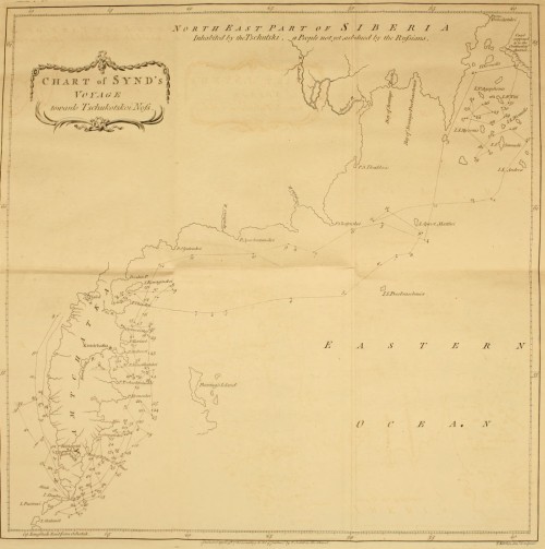
In 1764 Synd put to sea from the port of Ochotsk, but did not pass (we know not by what accident) the southern Cape of Kamtchatka and Shushu, the first Kuril Isle, before 1766. He then steered his course North at no great distance from the coast of the Peninsula, but made very little progress that year, for he wintered South of the river Uka.
The following year he sailed from Ukinski Point due East and North East, until he fell in with a cluster of islands[162] stretching between 61 and 62 degrees of latitude, and 195° and 202° longitude. These islands lie South East and East of the coast of the Tschutski; and several of them are situated very near the shore. Besides these small islands, he discovered also a mountainous coast lying within one degree of the coast of the Tschutski, between 64 and 66 North latitude; its most Western extremity was situated in longitude 38° 15´ from Ochotsk, or 199° 1´ from Fero. This island is laid down in his chart as part of the continent of America; but we cannot determine upon what proofs he grounds this representation, until a more circumstantial account of his voyage is communicated to the public. Synd seems to have made but a short stay ashore. Instead of endeavouring to survey its coasts, or of steering more to the East, he almost instantly shaped his course due West towards the course of the Tschutski, then turned directly South and South West, until he came opposite to Chatyrskoi Noss. From that point he continued to coast the peninsula of Kamtchatka, doubled the cape, and reached Ochotsk in 1768.
No X. Specimen of the Aleütian language.
SunAgaiya
MoonTughilag
WindKatshik
WaterTana
FireKighenag
Earth hutOollae
ChiefToigon
ManTaiyaga
WoodYaga
ShieldKuyak
Sea otterTscholota
Name of the nation.Kanagist.
OneTagatak
TwoAlag
ThreeKankoos
FourSetschi
FiveTshaw
SixAtoo
SevenOoloo
EightKapoé
NineShiset
Ten.Asok.
It is very remarkable, that none of these words bear the least resemblance to those of the same signification, which are found in the different dialects spoken by the Koriaks, Kamtchadals, and the inhabitants of the Kuril Isles.
No XI. Attempts of the Russians to discover a North East passage—Voyages from Archangel towards the Lena—From the Lena towards Kamtchatka—Extract from Muller's account of Deschneff's voyage round Tschukotskoi Noss—Narrative of a voyage made by Shalauroff from the Lena to Shelatskoi Noss.
The only communication hitherto known between the Atlantic and Pacific Oceans, or between Europe and the East Indies, is made either by sailing round the Cape of Good Hope, or by doubling Cape Horn. But as both these navigations are very long and dangerous, the great object of several late European voyages has been turned towards the discovery of a North East or a North West passage. As this work is entirely confined to the Russian navigations, any disquisition concerning the North West passage is totally foreign to the purpose; and for the same reason in what relates to the North East, these researches extend only to the attempts of the Russians for the discovery of that passage.
The advocates for the North East passage have divided that navigation into three principal parts; and by endeavouring to shew that these three parts have been passed at different times, they conclude from thence, that the whole when taken collectively is practicable.
These three parts are, 1. from Archangel to the Lena; 2. from the Lena to Kamtchatka; 3. from Kamtchatka to Japan. With respect to the latter, the connection between the seas of Kamtchatka and Japan first appeared from some Japanese vessels, which were wrecked upon the coast of Kamtchatka in the beginning of this century; and this communication has been unquestionably proved from several voyages made by the Russians from Kamtchatka to Japan[163].
No one ever asserted that the first part from Archangel to the Lena was ever performed in one voyage; but several persons having advanced that this navigation has been made by the Russians at different times, it becomes necessary to examine the accounts of the Russian voyages in those seas.
Voyages from Archangel to the Yenisèi.
In 1734 lieutenant Morovieff sailed from Archangel toward the river Oby; and got no farther the first year than the mouth of the Petchora. The next summer he passed through the straits ef Weygatz into the sea of Kara; and coasted along the Eastern side of that sea, as high as latitude 72° 30´, but did not double the promontory which separates the sea of Kara from the Bay of Oby. In 1738, the lieutenants Malgyin and Skurakoff doubled that promontory with great difficulty, and entered the bay of Oby. During these expeditions the navigators met with great dangers and impediments from the ice. Several unsuccessful attempts were made to pass from the bay of Oby to the Yenisèi, which was at last effected, in 1738, by two vessels commanded by lieutenants Offzin and Koskeleff. |Unsuccessful Attempt to pass from the Yenisèi to the Lena.| The same year the pilot Feodor Menin sailed from the Yenisèi rowards the Lena:he steered North as high as lat. 73°. 15´. and when he came to the mouth of the Piasida he was stopped by the ice; and finding it impossible to force a passage, he returned to the Yenisèi[164].
Voyage of Prontshistsheff from the Lena towards the Yenisèi.
July, 1735, lieutenant Prontshistsheff sailed from Yakutsk up the Lena to its mouth, in order to pass from thence by sea to the Yenisèi. The Western mouths of the Lena were so choaked up with ice, that he was obliged to pass through the most Easterly one; and was prevented by contrary winds from getting out until the 13th of August. Having steered North West along the islands which lie scattered before the mouths of the Lena, he found himself in lat. 70° 4´. He saw much ice to the North and North East; and observed ice-mountains from twenty-four to sixty feet in height. He steered betwixt the ice, which in no place left a free channel of greater breadth than an hundred or two hundred yards. The vessel being much damaged, on the 1st of September he ran up the mouth of the Olenek, which, according to his estimation, lies in 72° 30´, near which place he passed the winter[165].
He got out of the Olenek the beginning of August in the following year; and arrived on the third at the mouth of the Anabara, which he found to lie in lat. 73° 1´. There he continued until the 10th, while some of the crew went up the country in search of some mines. On the 10th he proceeded on his voyage: before he reached the mouth of the Chatanga he was so entirely surrounded and hemmed in with ice, that it was not without great difficulty and danger he was able to get loose. He then observed a large field of ice stretching into the sea, on which account he was obliged to continue near the shore, and to run up the Chatanga. The mouth of this river was in lat 74° 9´. From thence he bent his course mostly Northward along the shore, until he reached the mouth of the Taimura on the 18th. He then proceeded further, and followed the coast towards the Piasida. Near the shore were several small islands, between which and the land the ice was immovably fixed. He then directed his course toward the sea, in order to pass round the chain of islands. At first he found the sea more free to the North of the islands, while he observed much ice lying between them. He came at length to the last island, situated in lat. 77° 25´. Between this island and the shore, as well as on the other side of the island which lay most to the North, the ice was firm and immovable. |Prevented by a Chain of Islands and the Ice from getting to the Yenisèi| He attempted however to steer still more to the North; and having advanced about six miles, he was prevented by a thick fog from proceeding: this fog being dispersed, he saw on each side, and before him, nothing but ice; that towards the sea was not fixed; but the accumulated masses were all so close, that the smallest vessel could not have worked its way through. Still attempting however to pass to the North; he was forced by the ice N. E. Apprehensive of being hemmed in, he returned to the Taimura; and from thence got, with much difficulty and danger, to the Olenek, on the 29th of August.
This narrative of Prontshistsheff's expedition is extracted from the account of professor[166] Gmelin: according to Mr. Muller[167], who has given a cursory relation of the same voyage, Prontshistsheff did not quite reach the mouth of the Taimura; for he there found the chain of islands stretching from the continent far into the sea. The channels between the islands were so choaked up with ice, that it was impossible to force a passage: after steering as high as lat. 77° 25´, he found such a plain of fixed ice before him, that he had no prospect of getting any farther. Accordingly he returned to the Olenek.
Another attempt was made to pass from the Lena to the Yenisèi in 1739, by Chariton Laptieff, with equal bad success; and he relates, that between the rivers Piasida and Taimura, a promontory stretches into the sea which he could not double, the sea being entirely frozen up before he could pass round[168].
Cape between the Rivers Chatanga and Piasida never yet doubled.
From all these circumstances we must collect, that the whole space between Archangel and the Lena has never yet been navigated; for in going East from the Yenisèi the Russians could get no farther than the mouth of the Piasida; and, in coming West from the Lena, they were stopped, according to Gmelin, North of the Piasida; and, according to Muller, East of the Taimura.
The Russians, who sail almost annually from Archangel, and other towns, to Nova Zemla, for the purpose of catching sea-horses, seals, and white bears, make to the Western Coast; and no Russian vessel has ever passed round its North Eastern extremity[169].
Attempts of the Russians to pass from the Lena to Kamtchatka.
The navigation from the Lena to Kamtchatka now remains to be considered. If we may believe some authors, this navigation has been open for above a century and an half; and several vessels have at different times passed round the North Eastern extremity of Asia. But if we consult the Russian accounts, we shall find, that frequent expeditions have been unquestionably made from the Lena to the Kovyma; but that the voyage from the Kovyma round Tschukotskoi Noss, into the Eastern ocean, has been performed but once. According to Mr. Muller, this formidable cape was doubled in the year 1648. The material incidents of this remarkable voyage are as follow.
Narrative of Deshneff's voyage round Tschukotskoi-Noss.
In 1648 seven kotches or vessels sailed from the mouth or the river Kovyma[170], in order to penetrate into the Eastern Ocean. Of these, four were never more heard of: the remaining three were commanded by Simon Deshneff, Gerasim Ankudinoff, two chiefs of the Cossacs, and Fedot Alexeeff, the head of the Promyshlenics. Deshneff and Ankudinoff quarrelled before their departure: this dispute was owing to the jealousy of Deshneff, who was unwilling that Ankudinoff should share with him the honour, as well as the profits, which might result from the expected discoveries. Each vessel was probably manned with about thirty persons; Ankudinoff's, we certainly know, carried that number. Deshneff promised before-hand a tribute of seven fables, to be exacted from the inhabitants on the banks of Anadyr; so sanguine were his hopes of reaching that river. This indeed he finally effected; but not so soon, nor with so little difficulty, as he had presumed.
On the 20th of June, 1648, the three vessels sailed upon this remarkable expedition from the river Kovyma. Considering the little knowledge we have of the extreme regions of Asia, it is much to be regretted, that all the incidents of this voyage are not circumstantially related. Deshneff[171], in an account of his expedition sent to Yakutsk, seems only as it were accidentally to mention his adventures by sea: he takes no notice of any occurrence until he reached the great promontory of the Tschutski; no obstructions from the ice are mentioned, and probably there were none; for he observes upon another occasion, that the sea is not every year so free from ice as it was at this time. He commences his narrative with a description of the great promontory: "It is," says he, "very different from that which is situated West of the Kovyma, near the river Tschukotskia. It lies between North and North East, and bends, in a circular direction, towards the Anadyr. It is distinguished on the Russian (namely, the Western) side, by a rivulet which falls into the sea, close to which the Tschutski have raised a pile, like a tower, with the bones of whales. Opposite the promontory, (it is not said on which side), are two islands, on which he observed people of the nation of the Tschutski, who had pieces of the sea-horse tooth thrust into holes made in their lips. With a good wind it is possible to sail from this promontory to the Anadyr in three days; and the journey by land may be performed in the same space of time, because the Anadyr falls into a bay." Ankudinoff's kotche was wrecked on this promontory, and the crew was distributed on board the two remaining vessels. On the 20th of September Deshneff and Fedot Alexeef went on shore, and had a skirmish with the Tschutski, in which Alexeef was wounded. The two vessels soon afterwards lost sight of each other, and never again rejoined. Deshneff was driven about by tempestuous winds until October, when he was shipwrecked (as it appears from circumstances), considerably to the South of the Anadyr, not far from the river Olutora. What became of Fedot Alexeff and his crew will be mentioned hereafter. Deshneff and his companions, who amounted to twenty-five persons, now sought for the Anadyr; but being entirely unacquainted with the country, ten weeks elapsed before they reached its banks at a small distance from its mouth: here he found neither wood nor inhabitants, &c.
The following year he went further up the river, and built Anadirskoi Ostrog: here he was joined by some Russians on the 25th of April, 1650, who came by land from the river Kovyma. In 1652, Deshneff having constructed a vessel, sailed down the Anadyr as far as its mouth, and observed on the North side a sand bank, which stretched a considerable way into the sea. A sand bank of this kind is called, in Siberia, Korga. Great numbers of sea-horses were found to resort to the mouth of the Anadyr. Deshneff collected several of their teeth, and thought himself amply compensated by this acquisition for the trouble of his expedition. In the following year, Deshneff ordered wood to be felled for the purpose of constructing a vessel, in which he proposed sending the tribute which he had collected by sea to Yakutsk[172]. But this design was laid aside from the want of other materials. It was also reported, that the sea about Tschukotskoi Noss was not every year free from ice.
Another expedition was made in 1654 to the Korga, for the purpose of collecting sea-horse teeth. A Cossac, named Yusko Soliverstoff, was one of the party, the same who had not long before accompanied the Cossac Michael Stadukin, upon a voyage of discovery in the Frozen Sea. This person was sent from Yakutsk to collect sea-horse teeth, for the benefit of the crown. In his instructions mention is made of the river Yentshendon, which falls into the bay of Penshinsk, and of the Anadyr; and he was ordered to exact a tribute from the inhabitants dwelling near these rivers; for the adventures of Deshneff were not as yet known at Yakutsk. This was the occasion of new discontents. Soliverstoff claimed to himself the discovery of the Korga, as if he had sailed to that place in his voyage with Stadukin in 1649. Deshneff, however, proved that Soliverstoff had not even reached Tschukotskoi Noss, which he describes as nothing but bare rock, and it was but too well known to him, because the vessel of Ankudinoff was ship-wrecked there. "Tschukotskoi Noss," adds Deshneff, "is not the first promontory which presents itself under the name of Svatoi Noss[173]. It is known by the two islands situated opposite to it, whose inhabitants (as is before-mentioned) place pieces of the sea-horse tush into holes made in their lips. Deshneff alone had seen these people, which neither Stadukin nor Soliverstoff had pretended to have done: and the Korga, or sand-bank, at the mouth of the river Anadyr, was at some distance from these islands."
While Deschneff was surveying the sea-coast, he saw in an habitation belonging to some Koriacs a woman of Yakutsk, who, as he recollected, belonged to Fedot Alexieff. Upon his enquiry concerning the fate of her master, she replied, "that Fedot and Gerasim (Ankudinoff) had died of the scurvy; that part of the crew had been slain; that a few had escaped in small vessels, and have never since been heard off." Traces of the latter were afterwards found in the peninsula of Kamtchatka; to which place they probably arrived with a favourite wind, by following the coast, and running up the Kamtchatka river.
When Volodimir Atlassoff, in 1697, first entered upon the reduction of Kamtchatka, he found that the inhabitants had already some knowledge of the Russians. A common tradition still prevails amongst them, that long before the expedition of Atlassoff, one[174] Fedotoff (who was probably the son of Fedot Alexeeff) and his companions had resided amongst them, and had intermarried with the natives. They still shew the spot where the Russian habitations stood; namely, at the mouth of the small river Nikul which falls into the Kamtchatka river, and is called by the Russians Fedotika. Upon Atlassoff's arrival none of the first Russians remained. They are said to have been held in great veneration, and almost deified by the inhabitants, who at first imagined that no human power could hurt them, until they quarrelled amongst themselves, and the blood was seen to flow from the wounds which they gave each other: and upon a separation taking place between the Russians, part of them had been killed by the Koriacs, as they were going to the sea of Penshinsk, and the remainder by the Kamtchadals. The river Fedotika falls into the Southern side of the Kamtchatka river about an hundred and eighty versts below Upper Kamtchatkoi Ostrog. At the time of the first expedition to Kamtchatka, in 1697, the remains of two villages still subsisted, which had probably been inhabited by Fedotoff and his companions: and no one knew which way they came into the peninsula, until it was discovered from the archives of Yakutsk in 1636. [175] No other navigator, subsequent to Deshneff, has ever pretended to have passed the North Eastern extremity of Asia, notwithstanding all the attempts which have been made to accomplish this passage, as well from[176] Kamtchatka as from the Frozen Ocean.
Chart of Shalaurof's Voyage.
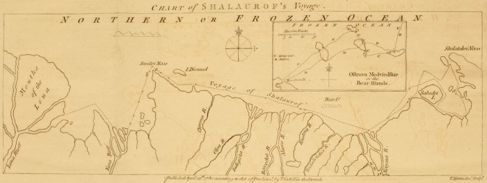
The following narrative of a late voyage performed by one Shalauroff, from the Lena towards Tschukotskoi-Noss, will shew the great impediments which obstruct a coasting navigation in the Frozen Sea, even at the most favourable season of the year.
Voyage of Shalauroff.
Shalauroff, having constructed a shitik at his own expence, went down the Lena in 1761. He was accompanied by an exiled midshipman, whom he had found at Yakutsk, and to whom we are indebted for the chart of this expedition. Shalauroff got out of the Southern mouth of the Lena in July, but was so much embarrassed by the ice, that he ran the vessel into the mouth of the Yana, where he was detained by the ice until the 29th of August, when he again set sail. Being prevented by the ice from keeping the open sea, he coasted the shore; and, having doubled Svatoi-Noss on the 6th of September, discovered at a small distance, out at sea, to the North, a mountainous land, which is probably some unknown island in the Frozen Sea. He was employed from the 7th to the 15th in getting through the strait between Diomed's island and the coast of Siberia; which he effected, not without great difficulty. From the 16th he had a free sea and a fair S. W. wind, which carried them in 24 hours beyond the mouth of the Indigirka. The favourable breeze continuing, he passed on the 18th the Alasca. Soon afterwards, the vessel approaching too near the shore was entangled amongst vast floating masses of ice, between some islands[177] and the main land. |Winters at the Mouth of the Kovyma.| And now the late season of the year obliged Shalauroff to look out for a wintering place; he accordingly ran the vessel into one of the mouths of the river Kovyma, where she was laid up. The crew immediately constructed an hut, which they secured with a rampart of frozen snow, and a battery of the small guns. The wild rein-deers resorted to this place in large herds, and were shot in great plenty from the enclosure. Before the setting in of winter, various species of salmon and trout came up the river in shoals: these fish afforded the crew a plentiful subsistence, and preserved them from the scurvy[178].
Departure from thence in July.
The mouth of the Kovyma was not freed from ice before the 21st of July, 1762, when Shalauroff again put to sea, and steered until the 28th N. E. by N. E. 1/4 E. Here he observed the variation of the compass ashore, and found it to be 11° 15´´ East. The 28th a contrary wind, which was followed by a calm, obliged him to come to an anchor, and kept him stationary until the 10th of August, when a favourable breeze springing up he set sail; he then endeavoured to steer at some distance from shore, holding a more Easterly course, and N. E. by E. But the vessel was impeded by large bodies of floating ice, and a strong current, which seemed to bear Westward at the rate of a verst an hour. These circumstances very much retarded his course. On the 18th, the weather being thick and foggy, he found himself unexpectedly near the coast with a number of ice islands before him, which on the 19th entirely surrounded and hemmed in the vessel. He continued in that situation, and in a continual fog, until the 23d, when he got clear, and endeavoured by steering N. E. to regain the open sea, which was much less clogged with ice than near the shore. He was forced however, by contrary winds, S. E. and E. among large masses of floating ice. This drift of ice being passed, he again stood to the N. E. in order to double Shelatskoi Noss[179]; but before he could reach the islands lying near it, he was so retarded by contrary winds, that he was obliged, on account of the advanced season, to search for a wintering place. |Not being able to double Shelatskoi Noss returns towards the Kovyma.| He accordingly sailed South towards an open bay, which lies on the West side of Shelatskoi Noss, and which no navigator had explored before him. He steered into it on the 25th, and got upon a shoal between a small island, and a point of land which juts from the Eastern coast of this bay. Having got clear with much difficulty, he continued for a short time a S. E. course, then turned S. W. He then landed in order to discover a spot proper for their winter residence; and found two small rivulets, but neither trees nor drift wood. The vessel was towed along the Southerly side of the bay as far as the island Sabadèi. On the 5th of September, he saw some huts of the Tschutski close to the narrow channel between Sabadèi and the main land; but the inhabitants fled on his approach.
Not having met with a proper situation, he stood out to sea, and got round the island Sabadèi on the 8th, when he fastened the vessel to a large body of ice, and was carried along by a current towards W. S. W. at the rate of five versts an hour. On the 10th, he saw far to the N. E. by N. a mountain, and steered the 11th and 12th towards his former wintering place in the river Kovyma. |Winters a second Time at the Kovyma, and returns to the Lena.| Shalauroff proposed to have made the following year another attempt to double Shelatskoi Noss; but want of provision, and the mutiny of the crew, forced him to return to the Lena in 1763. It is worth remarking, that during his whole voyage he found the currents setting in almost uniformly from the East. Two remarkable rocks were observed by Shalauroff near the point where the coast turns to the N. E. towards the channel which separates the island Sabadèi from the continent; these rocks may serve to direct future navigators: one is called Saetshie Kamen, or Hare's Rock, and rises like a crooked horn; the other Baranèi Kamen, or Sheep's Rock; it is in the shape of a pear, narrower at the bottom than at top, and rises twenty-nine yards above high-water mark.
Second Expedition of Shalauroff.
Shalauroff, who concluded from his own experience, that the attempt to double Tschukotskoi Noss, though difficult, was by no means impracticable, was not discouraged by his former want of success from engaging a second time in the same enterprize: he accordingly fitted out the same shitik, and in 1764 departed as before from the river Lena. We have no positive accounts of this second voyage; for neither Shalauroff or any of his crew have ever returned. The following circumstances lead us to conclude, that both he and his crew were killed near the Anadyr by the Tschutski, about the third year after their departure from the Lena. About that time the Koriacs of the Anadyr refused to take from the Russians the provision of flour, which they are accustomed to purchase every year. Enquiry being made by the governor of Anadirsk, he found that they had been amply supplied with that commodity by the Tschutski. The latter had procured it from the plunder of Shalauroff's vessel, the crew of which appeared to have perished near the Anadyr. |No Account of this Expedition, he and his Crew being killed by the Tschutski.| From these facts, which have been since confirmed by repeated intelligence from the Koriacs and Tschutski, it has been asserted, that Shalauroff had doubled the N. E. cape of Asia. But this assertion amounts only to conjecture; for the arrival of the crew at the mouth of the Anadyr affords no decisive proof that they had passed round the Eastern extremity of Asia; for they might have penetrated to that river by land, from the Western side of Tschukotskoi-Noss.
In reviewing these several accounts of the Russian voyages in the Frozen Sea, as far as they relate to a North East passage, we may observe, that the cape which stretches to the North of the Piasida has never been doubled; and that the existence of a passage round Tschukotskoi Noss rests upon the single authority of Deshneff. Admitting however a practicable navigation round these two promontories, yet when we consider the difficulties and dangers which the Russians encountered in those parts of the Frozen Sea which they have unquestionably sailed through; how much time they employed in making an inconsiderable progress, and how often their attempts were unsuccessful: when we reflect at the same time, that these voyages can only be performed in the midst of a short summer, and even then only when particular winds drive the ice into the sea, and leave the shores less obstructed; we shall reasonably conclude, that a navigation, pursued along the coasts in the Frozen Ocean, would probably be useless for commercial purposes.
A navigation therefore in the Frozen Ocean, calculated to answer any end of general utility, must (if possible) be made in an higher latitude, at some distance from the shores of Nova Zemla and Siberia. And should we even grant the possibility of sailing N. E. and East of Nova Zemla, without meeting with any insurmountable obstacles from land or ice; yet the final completion of a N. E. voyage must depend upon the existence of a free passage[180] between the coast of the Tschutski and the continent of America. But such disquisitions as these do not fall under the intention of this work, which is meant to state and examine facts, not to lay down an hypothesis, or to make theoretical enquiries[181].
APPENDIX II. Tartarian rhubarb brought to Kiachta by the Bucharian Merchants—Method of examining and purchasing the roots—Different species of rheum which yield the finest rhubarb—Price of rhubarb in Russia—Exportation—Superiority of the Tartarian over the Indian rhubarb.
Tartarian, or Turkey, Rhubarb.
Europe is supplied with rhubarb from Russia and the East Indies. The former is generally known by the name of Turkey rhubarb, because we used to import it from the Levant in our commerce with the Turks, who procured it through Persia from the Bucharians. And it still retains its original name, although instead of being carried, as before, to Constantinople, it is now brought to Kiachta by the Bucharian merchants, and there disposed of to the Russians. This appellation is indeed the most general; but it is mentioned occasionally by several authors, under the different denominations of Russian, Tartarian, Bucharian, and Thibet, Rhubarb. This sort is exported from Russia in large roundish pieces, freed from the bark, with an hole through the middle: they are externally of a yellow colour, and when cut appear variagated with lively reddish streaks.
Indian Rhubarb.
The other sort is called by the Druggists Indian Rhubarb; and is procured from Canton in longer, harder, heavier, more compact pieces, than the former; it is more astringent, and has somewhat less of an aromatic flavour; but, on account of its cheapness, is more generally used than the Tartarian or Turkey Rhubarb.
Tartarian Rhubarb procured at Kiachta.
The government of Russia has reserved to itself the exclusive privilege of purchasing rhubarb; it is brought to Kiachta by some Bucharian merchants, who have entered into a contract to supply the crown with that drug in exchange for furs. These merchants come from the town of Selin, which lies South Westward of the Koko-Nor, or Blue Lake toward Thibet. Selin, and all the towns of Little Bucharia; viz. Kashkar, Yerken, Atrar, &c. are subject to China.
The Rhubarb Plant grows upon the Mountains of Little Bucharia.
The best rhubarb purchased at Kiachta is produced upon a chain of rocks, which are very high, and for the most part destitute of wood: they lie North of Selin, and stretch as far as the Koko-Nor. The good roots are distinguished by large and thick stems. The Tanguts, who are employed in digging up the roots, enter upon that business in April or May. As fast as they take them out of the earth, they cleanse them from the soil, and hang them upon the neighbouring trees to dry, where they remain until a sufficient quantity is procured: after which they are delivered to the Bucharian merchants. The roots are wrapped up in woollen sacks, carefully preserved from the least humidity; and are in this manner transported to Kiachta upon camels.
The exportation of the best rhubarb is prohibited by the Chinese, under the severest penalties. It is procured however in sufficient quantities, sometimes by clandestinely mixing it with inferior roots, and sometimes by means of a contraband trade. The College of Commerce at Petersburg is solely empowered to receive this drug, and appoints agents at Kiachta for that purpose. Much care is taken in the choice; for it is examined, in the presence of the Bucharian merchants, by an apothecary commissioned by government, and resident at Kiachta. |Care taken in examining the roots at Kiachta.| All the worm-eaten roots are rejected; the remainder are bored through, in order to ascertain their soundness; and all the parts which appear in the least damaged or decayed are cut away. By these means even the best roots are diminished a sixth part; and the refuse is burnt, in order to prevent its being brought another year[182].
Different Species of Rhubarb.
Linnæus has distinguished the different species of rhubarb by the names Rheum Palmatum, R. Rhaphonticum,[183] R. Rhabarbarum, R. Compactum, and R. Ribes.
Botanists have long differed in their opinions, which of these several species is the true rhubarb; and that question does not appear to be as yet satisfactorily cleared up. |Rheum Palmatum.| However, according to the notion which is most generally received, it is supposed to be the Rheum[184] Palmatum; the seeds of which were originally procured from a Bucharian merchant, and distributed to the principal botanists of Europe. Hence this plant has been cultivated with great success; and is now very common in all our botanical gardens. The learned doctor[185]Hope, professor of medicine and botany in the university of Edinburgh, having made trials of the powder of this root, in the same doses in which the foreign rhubarb is given, found no difference in its effects; and from thence conclusions have been drawn with great appearance of probability, that this is the plant which produces the true rhubarb. But this inference does not appear to be absolutely conclusive; for the same trials have been repeated, and with similar success, upon the roots of the R. Rhaponticum and R. Rhabarbarum.
R. Rhaponticum.
The leaves of the R. Rhaponticum are round, and sometimes broader than they are long. This species is found abundantly in the loamy and dry deserts between the Volga and the Yaik[186], towards the Caspian Sea. It was probably from this sort that the name Rha, which is the Tartarian appellation of the river Volga, was first applied by the Arabian physicians to the several species of rheum. The roots however which grow in these warm plains are rather too astringent; and therefore ought not to be used in cases where opening medicines are required. The Calmucs call it Badshona, or a stomachic. The young shoots of this plant, which appear in March or April, are deemed a good antiscorbutic; and are used as such by the Russians. The R. Rhaponticum is not to be found to the West of the Volga. The seeds of this species produced at Petersburg plants of a much greater size than the wild ones: the leaves were large, and of a roundish cordated figure.
R. Rhabarbarum.
The R. Rhabarbarum grows in the crevices of bare rocky mountains, and also upon gravelly soils: it is more particularly found in the high vallies of the romantic country situated beyond Lake Baikal. Its buds do not shoot before the end of April; and it continues in flower during the whole month of May. The stalks of the leaves are eaten raw by the Tartars: they produce upon most persons, who are unaccustomed to them, a kind of sphasmodic contraction of the throat, which goes off in a few hours; it returns however at every meal, until they become habituated to this kind of diet. The Russians make use of the leaves in their hodge-podge: accordingly, soups of this sort affect strangers in the manner above mentioned. In Siberia the stalk is sometimes preserved as a sweet-meat; and a custom prevails among the Germans of introducing at their tables the buds of this plant, as well as of the Rheum Palmatum, instead of cauli-flower.
R. Rhaponticum.
The R. Rhaponticum which commonly grows near the torrents has, as well as the R. Rhabarbarum of Siberia, the upper part of its roots commonly rotten, from too much moisture: accordingly, a very small portion of the lower extremity is fit for use. The Russian College of Physicians order, for the use of their military hospitals, large quantities of these roots to be dug up in Siberia, which are prescribed under the name of rhapontic. But the persons employed in digging and preparing it are so ill instructed for that purpose, that its best juices are frequently lost. These roots ought to be drawn up in spring, soon after the melting of the snows, when the plant retains all its sap and strength; whereas they are not taken out of the ground before August, when they are wasted by the increase of the stem, and the expansion of the leaves. Add to this, that the roots are no sooner taken up, than they are immediately sliced in small pieces, and thus dried: by which means the medicinal qualities are sensibly impaired.
Method of drying the Roots of the R. Rhaponticum.
For the same roots, which in this instance were of such little efficacy, when dried with proper precaution, have been found to yield a very excellent rhubarb. The process observed for this purpose, by the ingenious Mr. Pallas, was as follows: The roots, immediately after being drawn out, were suspended over a stove, where being gradually dried, they were cleansed from the earth: by these means, although they were actually taken up in autumn, they so nearly resembled the best Tartarian rhubarb in colour, texture, and purgative qualities, that they answered, in every respect, the same medicinal purposes.
A German apothecary, named Zuchert, made similar trials with the same success, both on the Rheum Rhabarbarum and R. Rhaponticum, which grow in great perfection on the mountains in the neighbourhood of Nershinsk. |Plantation of Rhubarb in Siberia.| He formed plantations of these herbs on the declivity of a rock[187], covered with one foot of good mould, mixed with an equal quantity of sand and gravel. If the summer proved dry, the plants were left in the ground; but if the season was rainy, after drawing out the roots he left them for some days in the shade to dry, and then replanted them. By this method of cultivation he produced in seven or eight years very large and sound roots, which the rock had prevented from penetrating too deep; and when they were properly dried, one scruple was as efficacious as half a drachm of Tartarian rhubarb.
The Roots of the R. Rhaponticum and R. Rhubarbarum, equal in their Effects to the Tartarian Rhubarb.
From the foregoing observations it follows, that there are other plants, besides the Rheum Palmatum, the roots whereof have been found to be similar both in their appearance and effects, to what is called the best rhubarb. And indeed, upon enquiries made at Kiachta concerning the form and leaves of the plant which produces that drug, it seems not to be the R. Palmatum, but a species with roundish scolloped leaves, and most probably the R. Rhaponticum: for Mr. Pallas, when he was at Kiachta, applied for information to a Bucharian merchant of Selin-Chotton, who now supplies the crown with rhubarb; and his description of that plant answered to the figure of the Rheum Rhaponticum. The truth of this description was still further confirmed by some Mongol travellers who had been in the neighbourhood of the Koko-Nor and Thibet; and had observed the rhubarb growing wild upon those mountains.
The true Rhubarb probably procured from different Species of Rheum.
The experiments also made by Zuchert and others, upon the roots of the R. Rhabarbarum and R. Rhaponticum, sufficiently prove, that this valuable drug was procured from those roots in great perfection. the seeds of the Rheum Palmatum were received from the father of the above-mentioned Bucharian merchant as taken from the plant which furnishes the true rhubarb, we have reason to conjecture, that these three species, viz. R. Palmatum, R. Rhaponticum, and R. Rhabarbarum, when found in a dryer and milder alpine climate, and in proper situations, are indiscriminately drawn up; whenever the size of the plant seems to promise a fine root. And perhaps the remarkable difference of the rhubarb, imported to Kiachta, is occasioned by this indiscriminate method of collecting them. Most certain it is, that these plants grow wild upon the mountains, without the least cultivation; and those are esteemed the best which are found near the Koko-Nor, and about the sources of the river Koango.
Formerly the exportation of rhubarb was confined to the crown of Russia; and no persons but those employed by government were allowed the permission of sending it to foreign countries; this monopoly however has been taken off by the present empress, and the free exportation of it from St. Petersburg granted to all persons upon paying the duty. It is sold in the first instance by the College of Commerce for the profit of the Sovereign; and is preserved in their magazines at St. Petersburg. The current price is settled every year by the College of Commerce.
Price of Rhubarb in Russia.
It is received from the Bucharian merchants at Kiachta in exchange for furs; and the prime cost is rated at 16 roubles per pood. By adding the pay of the commissioners who purchase it, and of the apothecary who examines it, and allowing for other necessary expences, the value of a pood at Kiachta amounts to 25 roubles; add to this the carriage from the frontiers to St. Petersburg, and it is calculated that the price of a pood stands the crown at 30 roubles. The largest exportation of rhubarb ever known from Russia, was made in the year 1765, when 1350 pood were exported, at 65 roubles per pood.
Exportation of Rhubarb from St. Petersburg.
EXPORTATION of RHUBARB From St. Petersburg.
In 1777, 29 poods 13 pounds at 76-1/4 Dutch[188] dollars, or 91 roubles, 30 copecs per pood.
In 1778, 23 poods 7 pounds, at 80 ditto, or 96 roubles.
In 1778, 1055 poods were brought by the Bucharian merchants to Kiachta; of which 680 poods 19 pounds were selected. The interior consumption of the whole empire of Russia for 1777 amounted to only 6 poods 5 pounds[189].
Superiority of the Tartarian over the Indian Rhubarb.
The superiority of this Tartarian Rhubarb, over that procured from Canton, arises probably from the following circumstances.
1. The Southern parts of China are not so proper for the growth of this plant, as the mountains of Little Bucharia.
2. There is not so exact an examination made in receiving it from the Chinese at Canton, as from the Bucharians at Kiachta. For the merchants, who purchase this drug at Canton, are obliged to accept it in the gross, without separating the bad roots, and cutting away the decayed parts, as is done at Kiachta.
3. It is also probable, that the long transport of this drug by sea is detrimental to it, from the humidity which it must necessarily contract during so long a voyage.
TABLE of LONGITUDE and LATITUDE.
Table of Longitude and Latitude.
For the convenience of the Reader, the following Table exhibits in one point of view the longitude and latitude of the principal places mentioned in this performance. Their longitudes are estimated from the first meridian of the Isle of Fero, and from that of the Royal Observatory at Greenwich. The longitude of Greenwich from Fero is computed at 17° 34´ 45´´. The longitude of the places marked * has been taken from astronomical observations.
Latitude. Longitude.
Fero.Greenwich.
D.M.S. D.M.S. D.M.