ABORIGINAL REMAINS
Reading edition
IN
VERDE VALLEY, ARIZONA
BY
COSMOS MINDELEFF
CONTENTS
Page
Introduction 185
The region and its literature 185
Physical description of the country 189
Distribution and classification of ruins 192
Plans and descriptions 195
Stone villages 195
Cavate lodges 217
Bowlder-marked sites 235
Irrigating ditches and horticultural works 238
Structural characteristics 248
Masonry and other details 248
Door and window openings 251
Chimneys and fireplaces 256
Conclusions 257
Index
ILLUSTRATIONS
Illustrations have been placed as close as practicable to their discussion in the text. Page numbers refer to their original location in the printed book. Some Figures were previously used in the article on pueblo architecture cited in the Footnotes.
Thematic list of illustrations (added by transcriber).
Page
Plate X. Map showing distribution of ruins and location of area treated with reference to ancient pueblo region 185
XI. Map showing distribution of ruins in the basin of the Rio Verde 187
XII. Ground plan of ruin near mouth of Limestone creek 189
XIII. Main court, ruin near Limestone creek 191
XIV. Ruin at mouth of the East Verde 193
XV. Main court, ruin at mouth of the East Verde 195
XVI. Ruin at mouth of Fossil creek 197
XVII. Ground plan of ruins opposite Verde 199
XVIII. General view of ruins opposite Verde 201
XIX. Southern part of ruins opposite Verde 203
XX. General view of ruin on southern side of Clear creek 205
XXI. Detailed view of ruin on southern side of Clear creek 207
XXII. General view of ruin 8 miles north of Fossil creek 209
XXIII. General view of ruins on an eminence 14 miles north of Fossil creek 211
XXIV. General view of northern end of a group of cavate lodges 213
XXV. Map of group of cavate lodges 215
XXVI. Strata of northern canyon wall 217
XXVII. Ruin on northern point of cavate lodge canyon 219
XXVIII. Cavate lodge with walled front 221
XXIX. Open front cavate lodges on the Rio San Juan 223
XXX. Walled front cavate lodges on the Rio San Juan 224
XXXI. Cavate lodges on the Rio Grande 225
XXXII. Interior view of cavate lodge, group D 227
XXXIII. Bowlder-marked site 229
XXXIV. Irrigating ditch on the lower Verde 231
XXXV. Old irrigating ditch, showing cut through low ridge 233
XXXVI. Old ditch near Verde, looking westward 235
XXXVII. Old ditch near Verde, looking eastward 237
XXXVIII. Bluff over ancient ditch, showing gravel stratum 239
XXXIX. Ancient ditch and horticultural works on Clear creek 241
XL. Ancient ditch around a knoll, Clear creek 243
XLI. Ancient work on Clear creek 245
XLII. Gateway to ancient work, Clear creek 247
XLIII. Single-room remains on Clear creek 249
XLIV. Bowlder foundations near Limestone creek 251
XLV. Masonry of ruin near Limestone creek 253
XLVI. Masonry of ruin opposite Verde 255
XLVII. Standing walls opposite Verde 257
XLVIII. Masonry of ruin at mouth of the East Verde 259
XLIX. Doorway to cavate lodge 260
L. Doorway to cavate lodge 261
Fig. 279. Sketch map, site of small ruin 10 miles north of Fossil creek 200
280. Ground plan of ruin at mouth of the East Verde 201
281. Ground plan of ruin near the mouth of Fossil creek 204
282. Sketch map, site of ruin above Fossil creek 205
283. Sketch map of ruin 9½ miles above Fossil creek 206
284. Sketch map showing location of ruins opposite Verde 207
285. Ground plan of ruin on southern side of Clear creek 211
286. Ground plan of ruin 8 miles north of Fossil creek 213
287. Sketch map of ruins on pinnacle 7 miles north of Fossil creek 216
288. Remains of small rooms 7 miles north of Fossil creek 216
289. Diagram showing strata of canyon wall 218
290. Walled storage cist 221
291. Plan of cavate lodges, group D 226
292. Sections of cavate lodges, group D 227
293. Section of water pocket 228
294. Plan of cavate lodges, group A 229
295. Sections of cavate lodges, group A 230
296. Plan of cavate lodges, group B 231
297. Plan of cavate lodges, group E 232
298. Plan of cavate lodges, group C 233
299. Map of an ancient irrigation ditch 239
300. Part of old irrigating ditch 241
301. Walled front cavate lodges 250
302. Bowlders in footway, cavate lodges 252
303. Framed doorway, cavate lodges 253
304. Notched doorway in Canyon de Chelly 254
305. Notched doorway in Tusayan 255
Illustrations grouped by type (list added by transcriber) The distinction between a “site plan” and a “building plan” is not clear-cut; the illustration captions are inconsistent.
Site plans
Plate XXV. Map of group of cavate lodges
Fig. 279. Sketch map, site of small ruin 10 miles north of Fossil creek
282. Sketch map, site of ruin above Fossil creek
283. Sketch map of ruin 9½ miles above Fossil creek
284. Sketch map showing location of ruins opposite Verde
287. Sketch map of ruins on pinnacle 7 miles north of Fossil creek
288. Remains of small rooms 7 miles north of Fossil creek
299. Map of an ancient irrigation ditch
Building plans
Plate XII. Ground plan of ruin near mouth of Limestone creek
XVII. Ground plan of ruins opposite Verde
Fig. 280. Ground plan of ruin at mouth of the East Verde
281. Ground plan of ruin near the mouth of Fossil creek
285. Ground plan of ruin on southern side of Clear creek
286. Ground plan of ruin 8 miles north of Fossil creek
291. Plan of cavate lodges, group D
294. Plan of cavate lodges, group A
296. Plan of cavate lodges, group B
297. Plan of cavate lodges, group E
298. Plan of cavate lodges, group C
Sections
Fig. 292. Sections of cavate lodges, group D
293. Section of water pocket
295. Sections of cavate lodges, group A
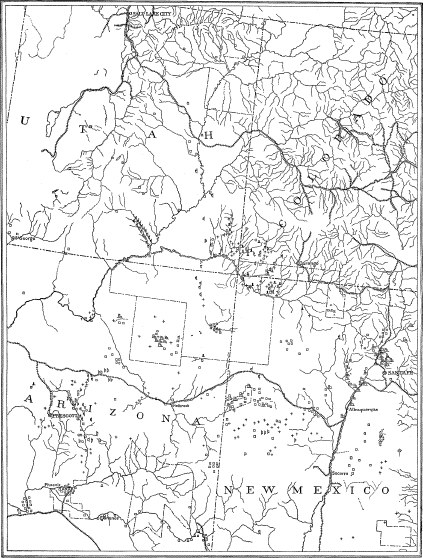
Plate X. Map Showing Distribution of Ruins and Location of Area Treated with Reference to Ancient Pueblo Region. larger view (705 × 973 pix) high-resolution version for printing(300dpi, 2818 × 3888 pix)