ABORIGINAL REMAINS IN VERDE VALLEY, ARIZONA (continued 2)
Reading edition
Above the cliffs, on the mesas, which have already been described, evidences of more ancient ruins were found. These were pueblos built of cut stone rudely dressed. Every mesa had at least one ancient pueblo up off it, evidently far more ancient than the cavate dwellings found in the face of the cliffs. It is, then, very plain that the cavate dwellings are not of great age; that they have been occupied since the advent of the white man, and that on the summit of the cliffs there are ruins of more ancient pueblos.
Major Powell obtained a tradition of the Santa Clara Indians, reciting three successive periods of occupancy of the cavate lodges by them, the last occurring after the Spanish conquest of New Mexico in the seventeenth century.
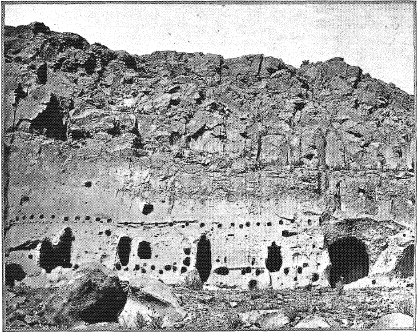
Plate XXXI. Cavate Lodges on the Rio Grande.
It will be noticed that here again the cavate lodges and village ruins are associated, although in this case the village ruins on the mesas above are said to be more ancient than the cavate lodges. A general view of a small section of cliff containing lodges is given in plate XXXI for comparison with those on the Verde. The lodges on the Rio Grande seem to have been more elaborate than those on the Verde, perhaps owing to longer occupancy; but the same arrangement of a main front room and attached back rooms, as in the cavate lodges on the Verde, was found.
As the cavate lodges of the San Francisco mountain region have been assigned to the Havasupai Indians of the Yuman stock, and those of the Rio Grande to the Santa Clara pueblo Indians of the Tanoan stock, it may be of interest to state that there is a vague tradition extant among the modern settlers of the Verde region that the cavate lodges of that region were occupied within the last three generations. This tradition was derived from an old Walapai Indian whose grandfather was alive when the cavate lodges were occupied. It was impossible to follow this tradition to its source, and it is introduced only as a suggestion. Attention is called, however, to the tradition given in the introduction to this paper with which it may be connected.
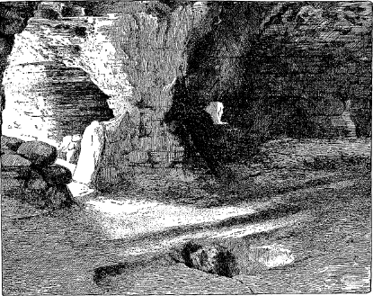
Plate XXXII. Interior View of Cavate Lodge, Group D.
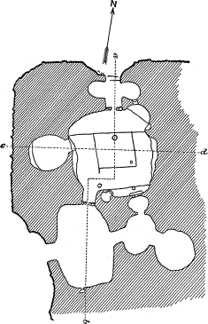
Fig. 291.—Plan of cavate lodges, group D. larger view
Aside from the actual labor of excavation, there was but little work expended on the Verde cavate lodges. The interiors were never plastered, so far as the writer could determine. Figure 291 shows the plan of one of the principal sets of rooms, which occurs at the point marked D on the map, plate XXV; and plate XXXII is an interior view of the principal room, drawn from a flashlight photograph. This set of rooms was excavated in a point of the cliff and extends completely through it as shown on the general plan, plate XXV. The entrance was from the west by a short passageway opening into a cove extending back some
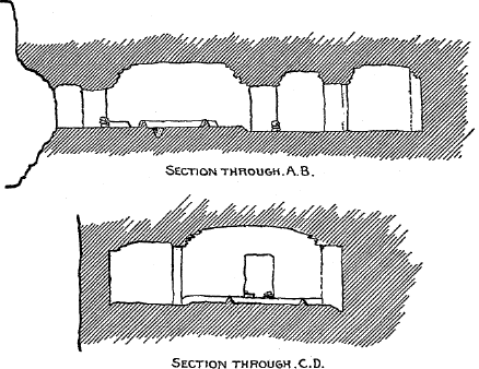
Fig. 292.—Sections of cavate lodges, group D.
The main room is roughly circular in form, measuring 16 feet in its north and south diameter and 15 feet from east to west. The roof is about 7 feet above the floor. Figure 292 shows a section from northwest to southwest (a, b, figure 291) through the small connected room adjoining on the south, and also an east arid west section (c, d, figure 291). The floor is plastered with clay wherever it was necessary in order to bring it to a level, and the coating is consequently not of uniform thickness. It is divided into sections by low ridges of clay as shown in the plan and sections; the northern section is a few inches higher than the other. Extending through the clay finish of the floor and into the rock beneath there are four pits, indicated on the plan by round spots. The largest of these, situated opposite the northern door, was a fire hole or pit about 18 inches in diameter at the floor level, of an inverted conical shape, about 10 inches in depth, and plastered inside with clay inlaid with fragments of pottery placed as closely together as their shape would permit. The other pits are smaller; one located near the southeastern corner of the room is about 6 inches in diameter
The room, when opened, contained a deposit of bat dung and sand about 3 feet thick in the center and averaging about 2 feet thick throughout the room. This deposit exhibited a series of well-defined strata, varying from three-fourths to an inch and a half thick, caused by the respective predominance of dung or sand. No evidence of disturbance of these strata was found although careful examination was made. This deposit was cleared out and a number of small articles were found, all resting, however, directly on the floor. The articles consisted of fragments of basketry, bundles of fibers and pieces of fabrics, pieces of arrowshafts, fragments of grinding stones, three sandals of woven yucca fiber, two of them new and nearly perfect, and a number of pieces of cotton cloth, the latter scattered over the room and in several instances gummed to the floor. Only a few fragments of pottery were found in the main room, but outside in the northern passageway were the fragments of two large pieces, one an olla, the other a bowl, both buried in 3 or 4 inches of debris under a large slab fallen from the roof.
Owing to its situation this room was one of the most desirable in the whole group. The prevailing south wind blows through it at all times, and this is doubtless the reason that it was so much filled up with sand. In the center of the room the roof has fallen at a comparatively recent date from an area about 10 by 7 feet, in slabs about an inch thick, for the fragments were within 6 inches of the top of the debris. The walls are smoke-blackened to a very slight extent compared with the large room south of it.
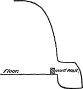
Fig. 293.—Section of water pocket.
At the northeastern and southwestern corners there are two small pockets, opening on the floor level but sunk below it, which seem to have been designed to contain water. That in the southwest corner is the larger; it is illustrated in the section, figure 293. As shown in the section and on the plan (figure 291), a low wall composed of adobe mortar and broken rock was built across the opening on the edge of the floor, perhaps to increase its capacity. This cavity would hold 15 to 20 gallons of water, a sufficient amount to supply the needs of an ordinary Indian family for three weeks or a mouth. The pocket in the northeastern corner of the room is not quite so large as the one described, and its front is not walled.
West of the main room there is a storage room, nearly circular in shape, with a diameter of about 6 feet and with a floor raised about 2 feet above that of the main room. Its roof is but 3 feet above the floor, and across its western end is a low bench a couple of inches above the
In the southeastern corner of the main room there is another opening leading into a low-roofed storage cist, approximating 4 feet in diameter, and this cist was in turn connected with the middle one of the three rooms first described. This opening, at the time the room was examined, was so carefully sealed and plastered that it was scarcely perceptible.
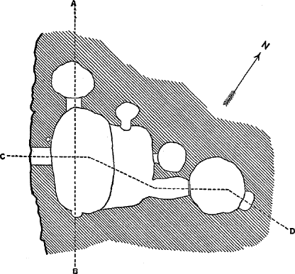
Fig. 294.—Plan of cavate lodges, group A. same figure, north at top
A different arrangement of rooms is shown in plan in figure 294 and in section in figure 295. This group occurs at the point marked A on the map. The entrance to the main room was through a narrow passage, 3 feet long, leading into the chamber from the face of the bluff, which at
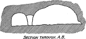

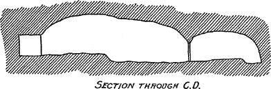
Fig. 295.—Sections of cavate lodges, group A.
East of the main room there is another of considerable size in the form of a bay or cove. It measures 13 feet by 6 feet, and its floor is 20 inches higher than that of the main room, as shown in the section (figure 295). Attached to this bay, at its northern end, is a small cist about 3 feet in diameter, and with its floor sunk to the level of the floor of the main room. East of the cove there is another cist about 4½ feet in diameter and with its floor on the level of the cove. Adjoining it on the south and leading out from the southeastern corner of the cove or bay, there is a long passage leading into an almost circular room 9 feet in diameter. The back wall of this room is 33 feet from the face of the cliff. The passage leading into it is 6 feet long, 2½ feet wide at the doorways, bulging slightly in the center, and its floor is on the same level as the rooms it connects; its eastern end is defined by a ridge of clay about 6 inches high.
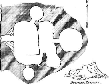
Fig. 296.—Plan of cavate lodges, group B.
A cluster of rooms somewhat resembling the last described is shown in plan in figure 296. This cluster occurs at the point marked B on the map. The main room is set back 5½ feet from the face of the bluff, which is vertical at this point, and is oblong in shape, measuring 19½ by 11½ feet. Its roof is 7½ feet above the floor in the center of the room. Attached to its southern end by a passage only a foot in length is a small room or storage cist about 5 feet in diameter. At its northeastern corner there is another room or cist similar in shape, about 7 feet in diameter, and reached by a passage 2 feet long. This small room is also connected with a long room east of the main apartment by a passage, the southern end of which was carefully sealed up and plastered, making a kind of niche of the northern end. At the southeastern corner of the room there is a small niche about 2 feet in diameter on the level of the floor.
The eastern side of the main room is not closed, but opens directly into an oblong chamber of irregular size with the roof nearly 2 feet lower and the floor a foot higher than the main room. This step in the floor is shown by the line between the rooms on the ground plan. The second room is about 6 feet wide and 20 feet long, its southern end rounding out slightly so as to form an almost circular chamber. Near
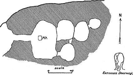
Fig. 297.—Plan of cavate lodges, group E.
A group occurring at the point marked E on the map (plate XXV) is shown in plan in figure 297. It is located in a projecting corner of the bluff and marks the eastern limit of the cavate lodges at this end of the canyon. The group consists of five rooms, and has the distinction of extending four rooms deep into the rock. The main room is set back about 13 feet from the face of the bluff, about 7 feet of this distance being occupied by a narrow passageway and the remainder by a cove. The depth from the face of the bluff to the back of the innermost chamber is 47 feet. The main room measures 16 feet in length and 11 feet in width, and its roof is less than 7 feet high in the center. Near its center and opposite the long passageway mentioned there is a fire-pit nearly 3 feet in diameter.
At the northeastern corner of the main room there is a wide opening leading into a room measuring 8 by 7 feet, with a floor raised 2 feet above that of the principal apartment. The roof of this chamber is but 4½ feet above the floor. Almost the whole eastern side of this room is occupied by a wide opening leading into another room of approximately the same size and shape. The roof of this room is only 3 feet 10 inches above the floor, and the floor is raised 6 inches above that on the west. In the northeastern corner there is a short narrow passageway leading into a small circular room, the fourth of the series, having a diameter of 4 feet. The roof of this apartment is only 3 feet above the floor.
In the southeastern corner of the main room there is a narrow passageway leading into a circular chamber about 8 feet in diameter. This chamber is connected with the second room of the series described by a passageway about 2 feet long, which opens into the southeastern
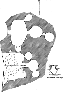
Fig. 298.—Plan of cavate lodges, group C. larger view
C on the map there is an elaborate group of chambers, consisting of two groups joined together and comprising altogether eight rooms. This is shown in plan in figure 298. The rock composing the front of the main room of the southern group has recently fallen, making a pile of debris about 4 feet high. The room originally measured about 12 by 22 feet. Its eastern side is occupied by a passageway leading into an adjoining chamber and by two shallow, roughly semicircular coves, apparently the remains of former small rooms. Along the northern wall of the room there are two little nooks at the floor level, and along the southern wall there are four, one of them (shown on the plan) being dug out like a pit. The roof of the room was about 6 feet above the floor.
The passageway near the eastern side is 4½ feet long, and is 3½ feet wide—an unusual width. It opens into a roughly circular room, 8 feet in diameter, but with a roof only 3½ feet above the floor. Along the northeastern side of this room, there are three small pockets opening on the floor level. On the southern side of the room there is a wide opening into a small attached room, roughly oblong in shape and measuring about 6½ by 4½ feet. Along the southern wall of this little room there are two small pockets, and at the southwestern corner the rock has been cleared out to form a low cavity in the shape of a half dome. In the northwestern corner of the room there is another wide passage to a small room attached to the main room. This passage is now carefully sealed on its southern side with a slab of stone, plastered neatly so as to be hardly perceptible from the southern side. The room into which this passage opens on the north is attached to the northeastern corner of the main apartment by a narrow passage, 1½ feet wide and a foot long. It is roughly circular in shape, about 6 feet in diameter, and is the only chamber in the southern group which has no pockets or cubby-holes. Of these pockets there are no fewer than twelve in the southern group. Near the northern corner of the main room there is a doorway leading into a cove, which in turn opens into the main room of the northern group.
The main room of the northern group is setback about 9 feet from the face of the bluff, but is entered by a passageway about 3 feet long, the remainder of the distance consisting of a cove in the cliff. The room is 22 feet long and 13 feet wide and its roof is 6½ feet above the floor. In the southwestern corner there is a small pocket in the wall, and in the northwestern corner two others, all on the floor level. In the eastern side, however, there is a cubby-hole nearly 2 feet in diameter and about 2 feet above the floor. This is a rare feature. The southern end of the room opens into a kind of cove, raised 2 feet above the floor of the main room, and opening at its southern end into the main room of the southern group. In the floor of this cove there is a circular pit about 18 inches in diameter (marked in the plan, figure 298). Although resembling the fire holes already described, the position of
Connected with the main room by a passageway 2 feet long cut in its eastern wall, there is an almost circular chamber 7 feet in diameter, and this in turn connects with another chamber beyond it by a passageway 2½ feet long and less than 2 feet wide. The roofs of the two chambers last mentioned are but 4½ and 4 feet, respectively, above the floor, and in none of the rooms of this group, except the main apartment, are pockets or niches found. The whole group extends back about 45 feet into the bluff.
BOWLDER-MARKED SITES.
Within the limits of the region here treated there are many hundreds of sites of structures and groups of rooms now marked only by lines of water-rounded bowlders. As a rule each site was occupied by only one or two rooms, although sometimes the settlement rose to the dignity of a village of considerable size. The rooms were nearly always oblong, similar in size and ground plan to the rooms composing the village ruins already described, but differing in two essential points, viz, character of site and character of the masonry. As a rule these remains are found on and generally near the edge of a low mesa or hill overlooking some area of tillable land, but they are by no means confined to such locations, being often found directly on the bottom land, still more frequently on the banks of dry washes at the points where they emerge from the hills, and sometimes on little islands or raised areas within the wash where every spring they must have been threatened with overflow or perhaps even overflowed. An examination of many sites leads to the conclusion that permanency was not an element of much weight in their selection.
Externally these bowlder-marked sites have every appearance of great antiquity, but all the evidence obtainable in regard to them indicates that they were connected with and inhabited at the same time as the other ruins in the region in which they are found. They are so much obliterated now, however, that a careful examination fails to determine in some cases whether the site in question was or was not occupied by a room or group of rooms, and there is a notable dearth of pottery fragments such as are so abundant in the ruins already described. Excavation in a large ruin of this type, however, conducted by some ranchmen living just above Limestone creek, yielded a considerable lot of pottery, not differing in kind from the fragments found in stone ruins so far as can be judged from description alone.
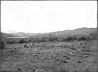
Plate XXXIII. Bowlder-Marked Site.
In the southern part of the region here treated bowlder-marked sites are more clearly marked and more easily distinguished than in the northern part, partly perhaps because in that section the normal ground XXXIII shows one of these bowlder-marked sites which occurs a little below Limestone creek, on the opposite or eastern side of the river. It is typical of many in that district. It will be noticed that the bowlders are but slightly sunk into the soil, and that the surface of the ground has been so slightly disturbed that it is practically level; there is not enough débris on the ground to raise the walls 2 feet. The illustration shows, in the middle distance, a considerable area of bottom land which the site overlooks. In plan this site shows a number of oblong rectangular rooms, the longer axes of which are not always parallel, the plan resembling very closely the smaller stone village ruins already described. It is probable that the lack of parallelism in the longer axes of the rooms is due to the same cause as in the village ruins, i.e., to the fact that the site was not all built up at one time.
The illustration represents only a part of an extensive series of wall remains. The series commences at the northern end of a mesa forming the eastern boundary of the Rio Verde and a little below a point opposite the mouth of Limestone creek. The ruins occur along the western rim of the mesa, overlooking the river and the bottom lands on the other side, and are now marked only by bowlders and a slight rise in the ground. But few lines of wall are visible, most of the ruins consisting only of a few bowlders scattered without system. From the northern end of the mesa, where the ruins commence, traces of walls can be seen extending due southward and at an angle of about 10° with the mesa edge for a distance of one-fourth of a mile. Beyond this, for half a mile or more southward, remains of single houses and small clusters occur, and these are found in less abundance to the southern edge of the mesa, where the ruin illustrated occurs. The settlement extended some distance east of the part illustrated, and also southward on the slope of the hill. Two well-marked lines of wall occur at the foot of the hill, on the flat bottom land, but the slopes of the hill are covered with bowlders and show no well-defined lines. Scattered about on the surface of the ground are some fragments of metates of coarse black basalt and some potsherds, but the latter are not abundant.
The bowlders which now mark these sites were probably obtained in the immediate vicinity of the points where they were used. The mesa on which the ruin occurs is a river terrace, constructed partly of these bowlders; they outcrop occasionally on its surface and show clearly in its sloping sides, and the washes that carry off the water falling on its surface are full of them.
In the northern end of the settlement there are faint traces of what may have been an irrigating ditch, but the topography is such that water could not be brought on top of the mesa from the river itself. At the southern end of the settlement, northeast of the point shown in the illustration, there are traces of a structure that may have been a
In the vicinity of the large ruin just above Limestone creek, previously described, the bowlder-marked sites are especially abundant. In the immediate vicinity of that ruin there are ten or more of them, and they are abundant all along the edge of the mesa forming the upper river terrace; in fact, they are found in every valley and on every point of mesa overlooking a valley containing tillable land.
It is probable that the bowlder-marked ruins are the sites of secondary and temporary structures, erected for convenience in working fields near to or overlooked by them and distant from the home pueblo. The character of the sites occupied by them and the plan of the structures themselves supports this hypothesis. That they were connected with the permanent stone villages is evident from their comparative abundance about each of the larger ones, and that they were constructed in a less substantial manner than the home pueblo is shown by the character of the remains.
It seems quite likely that only the lower course or courses of the walls of these dwellings were of bowlders, the superstructure being perhaps sometimes of earth (not adobe) but more probably often of the type known as “jacal”—upright slabs of wood plastered with mud. This method of construction was known to the ancient pueblo peoples and is used today to a considerable extent by the Mexican population of the southwest and to a less extent in some of the pueblos. No traces of this construction were found in the bowlder-marked sites, perhaps because no excavation was carried on; but it is evident that the rooms were not built of stone, and that not more than a small percentage could have been built of rammed earth or grout, as the latter, in disintegrating leaves well-defined mounds and lines of debris. It is improbable, moreover, that the structures were of brush plastered with mud, such as the Navajo hogan, as this method of construction is not well adapted to a rectangular ground plan, and if persistently applied would soon modify such a plan to a round or partially rounded one. Temporary brush structures would not require stone foundations, but structures composed of upright posts or slabs, filled in with brush and plastered with mud, and designed to last more
In the valley of the Rio Verde the profitable use of adobe at the present time is approximately limited northward by the thirty-fourth parallel, which crosses the valley a little below the mouth of Limestone creek. North of this latitude adobe is used less and less and where used requires more and more attention to keep in order, although on the high tablelands some distance farther northward it is again a suitable construction. South of the thirty-fourth parallel, however, adobe construction is well suited to the climate and in the valleys of Salt and Gila rivers it is the standard construction. Adobe construction (the use of sun-dried molded brick) was unknown to the ancient pueblo builders, but its aboriginal counterpart, rammed earth or pisé construction, such as that of the well known Casa Grande ruin on Gila river, acted in much the same way under climatic influences, and it is probable that its lack of suitability precluded its use in the greater part of the Verde valley. No walls of the type of those of the Casa Grande ruin have been found in the valley of the Verde, although abundant in the valleys of the Salt and Gila rivers, but it is possible that this method of construction was used in the southern part of the Verde region for temporary structures; in the northern part of that region its use even for that purpose was not practicable.
In this connection it should be noted that all the ruins herein described are of buildings of the northern type of aboriginal pueblo architecture and seem to be connected with the north rather than the south.
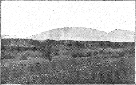
Plate XXXIV. Irrigating Ditch on the Lower Verde.
IRRIGATING DITCHES AND HORTICULTURAL WORKS.
One of the finest examples of an aboriginal irrigating ditch that has come under the writer’s notice occurs about 2 miles below the mouth of Limestone creek, on the opposite or eastern side of the river. At this point there is a large area of fertile bottom land, now occupied by some half dozen ranches, known locally as the Lower Verde settlement. The ditch extends across the northern and western part of this area. Plate XXXIV shows a portion of this ditch at a point about one eighth of a mile east of the river. Here the ditch is marked by a very shallow trough in the grass-covered bottom, bounded on either side by a low ridge of earth and pebbles. Plate XXXV shows the same ditch at a point about one-eighth of a mile above the last, where it was necessary to cut through a low ridge. North of this point the ditch can not be traced, but here it is about 40 feet above the river and about 10 feet above a modern (American) ditch. It is probable that the water was taken out of the river about 2 miles above this place, but the ditch was run on the sloping side of the mesa which has been recently XXXIV, but as the modern acequia, which enters the valley nearly 10 feet below the ancient one, extends up the valley nearly to its head, there is no reason to suppose that the ancient ditch did not irrigate nearly the whole area of bottom land. The ancient ditch is well marked by two clearly defined lines of pebbles and small bowlders, as shown in the illustration. Probably these pebbles entered into its construction, as the modern ditch, washed out at its head and abandoned more than a year ago, shows no trace, of a similar marking.
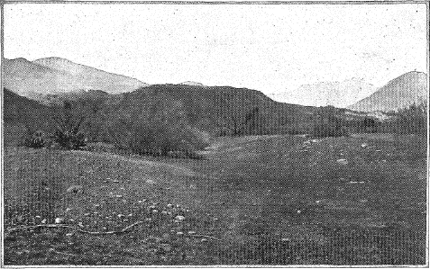
Plate XXXV. Old Irrigating Ditch, Showing Cut Through Low Ridge.
A little west and south of the point shown in plate XXXIV the bottom land drops off by a low bench of 3 or 4 feet to a lower level or terrace, and this edge is marked for a distance of about a quarter of a mile by the remains of a stone wall or other analogous structure. This is located on the extreme edge of the upper bench and it is marked on its higher side by a very small elevation. On the outer or lower side it is more clearly visible, as the stones of which the wall was composed are scattered over the slope marking the edge of the upper bench. At irregular intervals along the
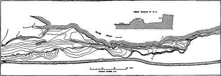
Fig. 299.—Map of an ancient irrigating ditch. larger view (lettering in red added by transcriber)
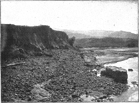
Plate XXXVI. Old Ditch Near Verde, Looking Westward.
In February, 1891, there was an exceptional flood in Verde river due to prolonged hard rain. The river in some places rose nearly 20 feet, and at many points washed away its banks and changed the channel. The river rose on two occasions; during its first rise it cut away a considerable section of the bank near a point known as Spanish wash, about 3½ miles below Verde, exposing an ancient ditch. During its second rise it cut away still more of the bank and part of the ancient ditch exposed a few days before. The river here makes a sharp bend and flows a little north of east. The modern American ditch, which supplied all the bottom lands of the Verde west of the river, was ruined in this vicinity by the flood that uncovered the old ditch. Figure 299 is a map of the ancient ditch drawn in the field, with contours a foot apart, and showing also a section, on a somewhat larger scale, drawn through the points A, B on the map. Plate XXXVI is a view of the ditch looking westward across the point where it has been washed away, and plate XXXVII shows the eastern portion, where the ditch disappears under the bluff.
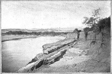
Plate XXXVII. Old Ditch Near Verde, Looking Eastward.
The bank of the river at this point consists of a low sandy beach, from 10 to 50 feet wide, limited on the south by a vertical bluff 10 to 12 feet high and composed of sandy alluvial soil. This bluff is the edge of the bottom land before referred to, and on top is almost flat and covered with a growth of mesquite, some of the trees reaching a diameter of more than 3 inches. The American ditch, which is shown on the map, runs along the top of the bluff skirting its edge, and is about 14 feet above the river at its ordinary stage. The edge of the bluff is shown on the map by a heavy black line. It will be observed that the ancient ditch occurs on the lower flat, about 3 feet above the river at its ordinary stage, and its remains extend over nearly 500 feet. The line, however, is not a straight one, but has several decided bends. One of these occurs at a point just west of that shown in the section. About 80 feet east of that point the ditch makes another turn southward, and about 40 feet beyond strikes the face of the bluff almost at right angles and passes under it.
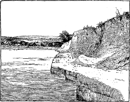
Fig. 300.—Part of old irrigating ditch.
About 50 feet north of the main ditch, at the point where it passes under the bluff, there are the remains of another ditch, as shown on the map. This second ditch was about a foot higher than the main structure, or about 4 feet above the river; it runs nearly parallel with it for 30 feet and then passes into the bluff with a slight turn toward the north. It is about the same size as the main ditch, but its section is more evenly rounded. Figure 300 shows this ditch in section.
As already stated, the American ditch is about 14 feet above the river, while the ancient ditch is less than 4 feet above the water. This decided difference in level indicates a marked difference in the character of the river. The destruction of the modern ditch by the flood of
At first sight it would appear that the ancient ditch antedated the deposit of alluvial soil forming the bottom land at this point, and this hypothesis is supported by several facts of importance. It is said that ten years ago the bottom land, whose edge now forms the bluff referred to, extended some 25 or 30 feet farther out, and that the river then flowed in a channel some 200 or 300 feet north of the present one. Be this as it may, the bottom land now presents a fairly continuous surface, from the banks of the river to the foothills that limit the valley on the west and south, and it is certain that this bottom land extended over the place occupied by the ancient ditch; nor is it to be supposed that the ancient ditches ended abruptly at the point where they now enter the bluff. The curves in the line of the ancient ditch might indicate that it was constructed along the slope of a hill, or on an uneven
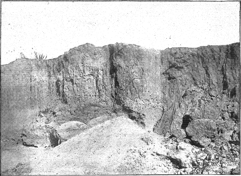
Plate XXXVIII. Bluff Over Ancient Ditch, Showing Gravel Stratum.
The face of the bluff shows an even deposit of sand, without apparent stratification, except here and there a thin layer or facing of mud occurs, such as covers the bottom of the ancient ditch and also of the modern ditch. Singularly enough, however, over the ancient ditch, about 5 feet above its bottom, there is a stratum of sand and gravel, and on top, within a few inches of the surface of the ground, a thin stratum of mud. This mud stratum extends only about 8 feet horizontally and is slightly hollowed, with its lowest part over the center of the ditch. The gravel stratum also was laid down over the ditch, is tilted slightly southward and occurs in two layers, together about a foot thick. It first appears a few feet south of the point where the main ditch enters the bluff and over the ditch both layers are distinctly marked, as shown in plate XXXVIII. Both layers are clearly marked to a distance of 4 feet north of the northern side of the main ditch; here the lower layer thins out, but the upper layer continues faintly marked almost to the edge of the small ditch. At this point the gravel stratum becomes pronounced again and continues over the small ditch, almost pure gravel in places, with a decided dip westward. At a point just beyond the northern side of the small ditch the gravel layer disappears entirely.
The occurrence of this gravel in the way described seems to indicate that the ditch was built along the slope of a low hill forming the edge of the bottom land at that time, and that subsequently detritus was deposited above it and over the adjacent bottom land forming a smooth ground surface. Against this hypothesis it must be stated that no evidence whatever was found of more than a single deposit of sandy loam, although the exposures are good; but perhaps were an examination made by a competent geologist some such evidence might be developed.
There is one fact that should not be lost sight of in the discussion, viz, the very low elevation of the ditch above the river. The Verde is, as already stated, a typical mountain stream, with an exceptionally high declivity, and consequently it is rapidly lowering its bed. If, as already conjectured, the water for the ancient ditch was taken from the river but a short distance above the point where remains of the ditch are now found—and this assumption seems well supported by the character of the adjacent topography—the slight elevation of the bed of the ditch above the river would indicate that, in the first place, the ditch was located, as already suggested, along the slope of a hill, and in the second place, that the ditch was built at a period of no great antiquity. The occurrence of the high bluff under which the ditch now passes does not conflict with this suggestion, for the deposition of the material composing it and its erosion into its present form and condition may be the result of decades rather than of centuries of work by
In conclusion it should be noted, in support of the hypothesis that the ditch was built before the material composing the bluff was laid down, that immediately under the ditch there is a stratum of hard adobe-like earth, quite different from the sand above it and from the material of which the bluff is composed. This stratum is shown clearly in plate XXXVIII.
The hypothesis which accords best with the evidence now in hand is that which assumes that the ditch was taken out of the river but a short distance above the point illustrated, and that it was built on the slope of a low hill, or on a nearly flat undulating bottom land, before the material composing the present bottom or river terrace was deposited, and that the ditch, while it may be of considerable antiquity, is not necessarily more than a hundred or a hundred and fifty years old; in other words, we may reach a fairly definite determination of its minimum but not of its maximum antiquity.
On the southern side of Clear creek, about a mile above its mouth, there are extensive horticultural works covering a large area of the terrace or river bench. These have already been alluded to in the description of the village ruin overlooking them, but there are several features which are worthy a more detailed description. For a distance of 2 miles east and west along the creek, and perhaps half a mile north and south, there are traces of former works pertaining to horticulture, including irrigating ditches, “reservoirs,” farming outlooks, etc.
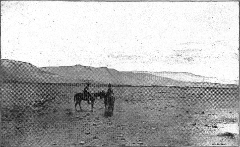
Plate XXXIX. Ancient Ditch and Horticultural Works on Clear Creek.
At the eastern end of these works, about 3 miles above the mouth of Clear creek, the main ditch, after running along the slope of the hill for some distance, comes out on top of the mesa or terrace nearly opposite the Morris place. The water was taken from the creek but a short distance above, hardly more than half a mile. West of the point where the ditch comes out on the mesa top, all traces of it disappear, but they are found again at various points on the terrace. Plate XXXIX shows a portion of the terrace below and opposite the rectangular ruin previously described. In the distant foreground the light line indicates a part of the ancient ditch. Plate XL shows the same ditch at a point half a mile below the last, where it rounds a knoll. In the distance is the flat-topped hill or mesa on which the rectangular ruin previously described is located. About a hundred yards southeast of this point further traces of the ditch may be seen, and connected with it at that point are a number of rectangular areas, which were cultivated patches when the ditch was in use.
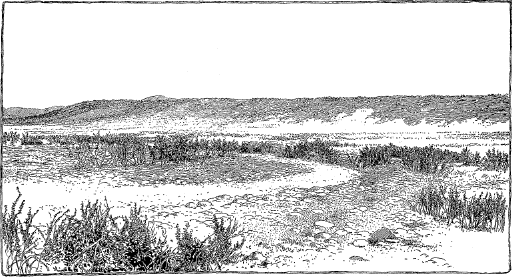
Plate XL. Ancient Ditch Around a Knoll, Clear Creek.
The whole surface of the terrace within the limits described is covered by small water-worn bowlders scattered so thickly over it that travel is seriously impeded. In many parts of it these bowlders are arranged so as to inclose small rectangular areas, and these areas are connected with the old ditch just described. Plate XXXIX shows something of this surface character; and in the right hand portion of it may be seen some of the rows of bowlders forming the rectangular areas. The rows which occur at right angles to the ditch are much more clearly marked than those parallel to it, and the longer axes of the rectangular areas are usually also at right angles to the ditch line. On the ground these traces of inclosures can hardly be made out, but from an elevated point, such as the mesa on which, the rectangular ruin overlooking these works is located, they show very clearly and have the appearance of windrows. Traces of these horticultural works would be more numerous, and doubtless more distinct, were it not that a considerable part of the area formerly under cultivation has been picked over by the modern settlers in this region, and immense quantities of stone have been removed and used in the construction of fences. This has not been done, however, in such a manner as to leave the ground entirely bare, yet bare areas occur here and there over the surface, where doubtless once existed a part of the general scheme of horticultural works.
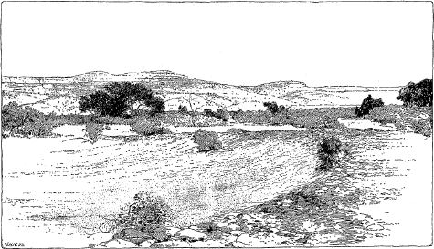
Plate XLI. Ancient Work on Clear Creek.
One such bare area occurs close to the edge of the terrace about a mile and a half above the mouth of the creek. In its center is a structure called for convenience a reservoir, although it is by no means certain that it was used as such. It occurs about 100 yards from the creek, opposite the Wingfield place, and consists of a depression surrounded by an elevated rim. It is oval, measuring 108 feet north and south and 72 feet east and west from rim to rim. The crown of the rim is 5 feet 8 inches above the bottom of the depression and about 3 feet above the ground outside. The rim is fairly continuous, except at points on the northern and southern sides, where there are slight depressions, and these depressions are further marked by extra large bowlders. At its lowest points, however, the rim is over 2 feet above the ground, which slopes away from it for some distance in every direction. Plate XLI shows the eastern side of the depression; the large tree in the middle distance is on the bank of Clear creek and below the terrace. Plate XLII shows the northern gateway or dip in the rim, looking southward across the depression. The large bowlders previously referred to can be clearly seen. A depression similar to this occurs on the opposite side of the valley, about half a mile from the river. In this case it is not marked by bowlders or stones of any description, but is smooth and rounded, corresponding to the surface of the ground in its vicinity. In the latter as in the former case, the depression occurs on a low knoll or swell in the bottom land, and the surface of the ground slopes gently away from it for some distance in every direction.
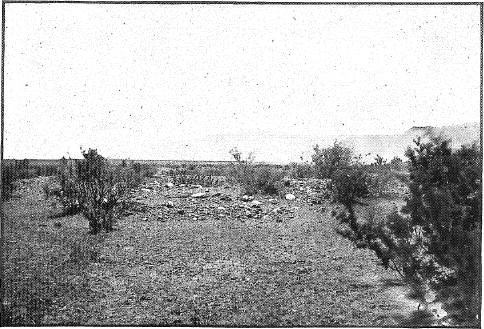
Plate XLII. Gateway to Ancient Work, Clear Creek.
If these depressions were used as reservoirs it is a fair presumption that the bottoms were plastered with clay, so that there would be no seepage and the only loss would be by evaporation. Yet this loss, in a dry and windy climate such as that of the region here treated, would be sufficient to render impracticable a storage reservoir of a cross section and a site like the one under discussion. Most of the rainfall is in the winter months, from December to March, and it would require a fall of over 12 inches during those months to render the reservoir of any use in June; it would certainly be of no use in July and August, at the time when water is most needed, save in exceptional years with rainfall much in excess of the mean.
On the other hand, there is the hypothesis that these depressions represent house structures; but if so these structures are anomalous in this region. The contour of the ground does not support the idea of a cluster of rooms about a central court, nor does the débris bear it out. Mr. F. H. Cushing has found depressions in the valleys of Salt and Gila rivers somewhat resembling these in form and measurement, and situated always on the outskirts of the sites of villages. Excavations were made, and as the result of these he came to the conclusion that
There is a third hypothesis which, though not supported by direct evidence, seems plausible. It is that the depression of Clear creek, and perhaps also the one on the opposite side of the Verde, were thrashing floors. This hypothesis accords well with the situation of these depressions upon the tillable bottom lands, and with their relation to the other remains in their vicinity; and their depth below the surface of the ground would be accounted for, under the assumption here made of their use, by the high and almost continuous winds of the summer in this region. Perhaps the slight depressions at the northern and southern side of the oval were the gateways through which the animals which trampled the straw or the men who worked the flails passed in and out. Whether used in this way or not, these depressions would be, under the assumption that the bottom was plastered with mud, not only practicable, but even desirable thrashing floors, as the grain would be subjected during thrashing to a partial winnowing. This suggestion would also account for the comparatively clean ground surface about the depressions and for their location on slightly elevated knolls.
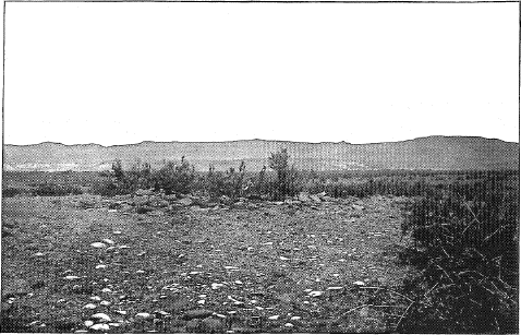
Plate XLIII. Single-Room Remains on Clear Creek.
Scattered over the whole area formerly under cultivation along Clear creek are the remains of small, single rooms, well marked on the ground, but without any standing wall remaining. These remains are scattered indiscriminately over the terrace without system or arrangement; they are sometimes on the flat, sometimes on slight knolls. They number altogether perhaps forty or fifty. Plate XLIII shows an example which occurs on a low knoll, shown also in plate XL; it is typical of these remains. It will be noticed that the masonry was composed of river bowlders not dressed or prepared in any way, and that the débris on the ground would raise the walls scarcely to the height of a single low story.
The location of these remains, their relation to other remains in the vicinity, and their character all support the conclusion that they were
As it is impossible that an area so large as this should be cultivated by the inhabitants of one village, it is probable that a number of villages combined in the use of this terrace for their horticultural operations; and, reasoning from what we know to have been the case in other regions, it is further probable that this combination resulted in endless contention, and strife, and perhaps finally to the abandonment of these fields if not of this region. The rectangular ruin already illustrated is situated on a hill south of the terrace and overlooks it from that direction; on the opposite side of Clear creek, on the hill bounding the valley on the north, there are the remains of a large stone village which commanded an outlook over the terraces in question; and a little farther up the creek, on the same side and similarly situated, there was another village which also overlooked them. There were doubtless other villages and small settlements whose remains are not now clearly distinguishable, and it is quite probable that some of the inhabitants of the large villages in the vicinity, like those near Verde, hardly 3 miles northward, had a few farming houses and some land under cultivation on this terrace.
Thus it will be seen that there was no lack of cultivators for all the tillable land on the terrace, and there is no reason to suppose that the period when the land was under cultivation, and the period when the villages overlooking it were occupied, were not identical, and that the single-house remains scattered over the terrace were not built and occupied at the same period. The relation of the stone villages to the area formerly cultivated, the relation of the single-room remains to the area immediately about them, the character of the remains, and the known methods of horticulture followed by the Pueblo Indians, all support the conclusion that these remains were not only contemporaneous but also related to one another.
STRUCTURAL CHARACTERISTICS.
MASONRY AND OTHER DETAILS.
The masonry of the stone villages throughout all the region here treated is of the same type, although there are some variations. It does not compare with the fine work found on the San Juan and its tributaries, although belonging to that type—the walls being composed of two faces with rubble filling, and the interstices of the large stones being filled or chinked with spalls. This chinking is more pronounced and better done in the northern part of the region than in the south.
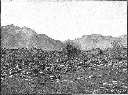
Plate XLIV. Bowlder Foundations Near Limestone Creek.
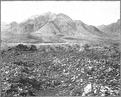
Plate XLV. Masonry of Ruin Near Limestone Creek.
The rock employed depended in all cases on the immediate environments of the site of the village, the walls being composed in some cases of slabs of limestone, in other cases of river bowlders only, and in still others of both in combination. The walls of the large ruin near Limestone creek were composed of rude slabs of limestone with an intermixture of bowlders. The bowlders usually occur only in the lower part of the wall, near the ground, and in several cases, where nothing exists of the wall above the surface of the ground, the remains consist entirely of bowlders. A good example of this peculiarity of construction is shown in plate XLIV, and plate XLV shows the character of stone employed and also a section of standing wall on the western side of the village. A section of standing wall near the center of the ruin is illustrated in plate XIII. It will be noticed that some of the walls shown in this illustration are chinked, but to a very slight extent. The wall represented in plate XLV has slabs of limestone set on edge. This feature is found also in other ruins in this region, notably in those opposite Verde, though it seems to be more used in the south than in the north. An example occurring in the ruin opposite Verde is shown in plate XLVI. In this case chinking is more pronounced; the walls are from 2 to 2½ feet thick, built in the ordinary way with two faces and an interior filling, but the stones are large and the filling is almost wholly adobe mortar. The two faces are tied together by extra long stones which occasionally project into the back of one or the other face.
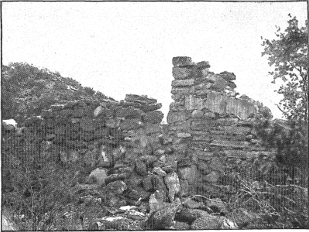
Plate XLVI. Masonry of Ruin Opposite Verde.
The western cluster of the ruin last mentioned, shown on the ground plan (plate XVII), has almost all its walls still standing, and the masonry, while of the same general character as that of the main cluster, is better executed. The stones composing the walls are smaller than those in the main cluster and more uniform in size, and the interstices are carefully chinked. The chinking is distinctive in that spalls were not used, but more or less flattened river pebbles. The different color and texture of these pebbles make them stand out from the wall distinctly, giving quite an ornamental effect.
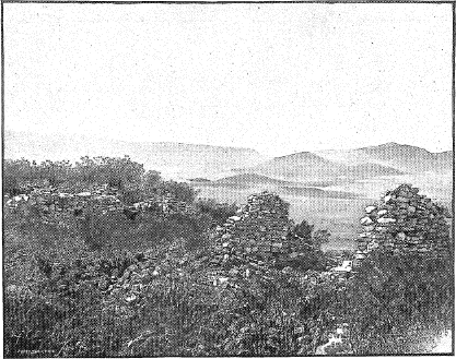
Plate XLVII. Standing Walls Opposite Verde.
That portion of the standing wall of the ruin opposite Verde, which occurs in the saddle northeastward from the main cluster, shown on the plan in plate XVII, represents the best masonry found in this region. As elsewhere stated, this was probably the last part of the village to be built. These walls are shown in plate XLVII. It will be noticed that the stones are of very irregular shape, rendering a considerable amount of chinking necessary to produce even a fair result, and that the stones are exceptionally large. The masonry of this village is characterized by the use of stones larger than common, many of them being larger than one man can carry and some of them even larger than two men can handle.
All the larger and more important ruins of this region are constructed of limestone slabs, sometimes with bowlders. The smaller ruins, on the other hand, were built usually of river bowlders, sometimes with an intermixture of slabs of limestone and sandstone but with a decided preponderance of river bowlders. This would seem to suggest that this region was gradually populated, and that the larger structures were the last ones built. This suggestion has been already made in the discussion of the ground plans, and it is, moreover, in accord with the history of the pueblo-builders farther northward, notably that of the Hopi.
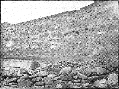
Plate XLVIII. Masonry of Ruin at Mouth of the East Verde.
Plate XXI illustrates a type of bowlder masonry which occurs on Clear creek; plate XLVIII shows the masonry of the ruin at the mouth of the East Verde, and plate XVI shows that of a ruin at the month of Fossil creek. In all these examples the stone composing the walls was derived either from the bed of an adjacent stream or from the ground on which they were built, and was used without any preparation whatever; yet in the better examples of this type of masonry a fairly good result was obtained by a careful selection of the stones. A still ruder type of masonry sometimes found in connection with village ruins is shown in figure 290. This, however, was used only as in the example illustrated, for retaining walls to trails or terraces, or analogous structures.
In a general way it may be stated that the masonry of the village ruins of this region is much inferior to that of the San Juan region, and in its rough and unfinished surfaces, in the use of an inferior material close at hand rather than a better material a short distance away, and in the ignorance on the part of the builders of many constructive devices and expedients employed in the best examples of pueblo masonry, the work of this region may be ranked with that of the Tusayan—in other words, at the lower end of the scale.
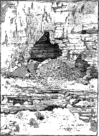
Fig. 301.—Walled front cavate lodges.
There is but little masonry about the cavate lodges, and that is rude in character. As elsewhere stated, walled fronts are exceptional in this region, and where they occur the work was done very roughly. Figure 301 shows an example that occurs in the group of cavate lodges already described. It will be noticed that little selection has been exercised in the stones employed, and that an excess of mortar has been used to fill in the large interstices. Figure 290 (p. 221), which shows a storage cist attached to the group of cavate lodges, marked D on the map (plate XXV), exhibits the same excessive use of adobe or mud plastering. At several other points in the area shown on this map there are short walls, sometimes inside the lodges, sometimes outside. In all cases, however, they are rudely constructed and heavily plastered with mud; in short, the masonry of the cavate lodges exhibits an ignorance fully equal to that of the stone villages, while the execution is, if anything, ruder. It is singular that, notwithstanding the excessive use of mud mortar and mud plastering in the few walls that are found there, such plastering was almost never used on the walls in the
The cavate lodges seem to have been excavated without the aid of other tools than a rough maul or a piece of stone held in the hand, and such a tool is well adapted to the work, since a blow on the surface of the rock is sufficient to bring off large slabs. Notwithstanding the rude tools and methods, however, some of the work is quite neat, especially in the passageways (which are often 3 or 4 feet long and quite narrow) and in the smaller chambers. In the excavation of these chambers benches were left at convenient places along the wall and niches and cubby-holes were cut, so that in the best examples of cavate lodges the occupants, it would seem, were more comfortable, so far as regards their habitation, than the ordinary Pueblo Indian of today, and better supplied with the conveniences of that method of living. It should be stated in this connection, however, that although the group of cavate lodges gives an example of an extensive work well carried out, the successful carrying out of that work does not imply either a large population or a high degree of skill; the only thing necessary was time, and the amount of time necessary for the work is not nearly so great, in proportion to the population housed, as was required for the better types of pueblo work in the San Juan country (the village ruins of the Chaco canyon for example), and probably no more than would be required for the construction of rooms of equal size and of the rather poor grade of work found in this region.
Although no examples of interior wall-plastering were found in the group of cavate lodges described, such work has been found in neighboring lodges; and in this group plastered floors are quite common. The object of plastering the floors was to secure a fairly even surface such as the soft rock did not provide, and this was secured not by the application of layers of clay but by the use of clay here and there wherever needed to bring the surface up to a general level, and the whole surface was subsequently finished. This final finishing was sometimes omitted, and many floors are composed partly of the natural rock and partly of clay, the latter frequently in spots and areas of small size.
The floors were often divided into a number of sections by low ridges of clay, sometimes 8 inches broad. These ridges are shown on the ground plans (figures 294 to 298, and in plate XXV). Their purpose is not clear, although it can readily be seen that in such domestic operations as sorting grain they would be useful.
DOOR AND WINDOW OPENINGS.
The masonry of this region was so roughly and carelessly executed that little evidence remains in the stone villages of such details of construction as door and window openings. Destruction of the walls seems to have commenced at these openings, and while there are
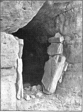
Plate XLIX. Doorway to Cavate Lodge.
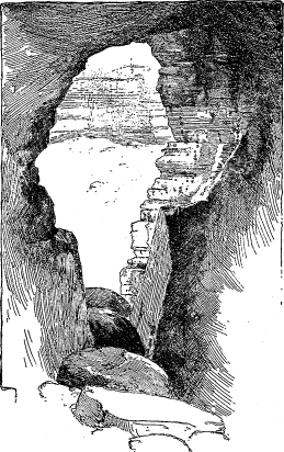
Fig. 302.—Bowlders in footway, cavate lodges.
In the cavate lodges window openings are not found; there is but one opening, the doorway, and this is of a pronounced and peculiar type. As a rule these doorways are wider at the top than at the bottom and there are no corners, the opening roughly approximating the shape of a pear with the smaller end downward. The upper part of the opening consists always of the naked rock, but the lower part is generally XLIX shows an example that occurs in the upper tier of lodges at its eastern end. The floor of this lodge is about 2 feet above the bench from which it was entered, and this specimen fails to show a feature which is very common in this group—a line of water-worn bowlders extending from the exterior to the interior of the lodges through the doorway and arranged like stepping stones. This feature is shown in figure 302, which represents the doorway of group E, shown on the general map (plate XXV) and on the detailed figure 297. Figure 303 shows a type in which the framing is extended up on one side nearly to the top, while on the other side it extends only to half the height of the opening, which above the framing is hollowed out to increase its width. This example occurs near that shown in plate XLIX, and the floor of the chamber is raised about 2 feet above the bench from which it is entered. The illustration gives a view from the interior, looking out, and the large opening on the right was caused by the comparatively recent breaking out of the wall. Figure 303 shows the doorway to the group of chambers marked E on the general map, an interior view of which is shown in figure 302. In this example the obvious object of the framing was to reduce the size of the opening, and to accomplish this the slabs were set out 10 or 12 inches from the rock forming the sides of the opening, and the intervening space was filled in with rubble. Plate plate XXXII, which shows the interior of the main room in group D, shows also the large doorway on the north.
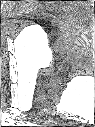
Fig. 303.—Framed doorway, cavate lodges.
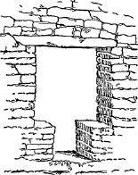
Fig. 304.—Notched doorway in Canyon de Chelly.
It will be noticed that these doorways all conform to one general plan and that this plan required an opening considerably larger in its upper third than in the lower two-thirds of its height. This requirement seems to be the counterpart or analogue of the notched doorway, which is the standard type in the cliff ruins of Canyon de Chelly and other regions, and still very common in Tusayan (Moki). Figure 304 shows a notched doorway in Canyon de Chelly and figure 305 gives an example of the same type of opening in Tusayan. The object of this peculiar shape in the regions mentioned has been well established,9 and there is no reason to suppose that similar conditions and a similar object would not produce a similar result here. This type of opening had its origin in the time when the pueblo builders had no means, other than blankets, of temporarily closing door openings and when all the supplies of the village were brought in on the backs of the inhabitants. In order to secure protection against cold and storm the opening was made of the smallest possible size consistent with its use, and the upper part of the opening was made larger in order to permit the introduction of back loads of faggots and other necessaries. This purpose would be almost as well served by the openings of the cavate lodges as by the notched doorway, and at the same time the smallest possible opening was exposed to the weather. The two types of openings seem
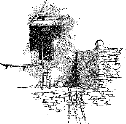
Fig. 305.—Notched doorway in Tusayan.
CHIMNEYS AND FIREPLACES.
Nowhere in the village ruins or in the cavate lodges of the lower Verde were any traces of chimneys or other artificial smoke exits found. The village ruins are too much broken down to permit definite statement of the means employed for smoke exits, but had the inhabitants employed such exits as are in use in the pueblos today some evidence of them would remain. Probably there was no other exit than the door, and perhaps trapdoors or small openings in the roofs, such as were formerly employed in the inhabited pueblos, according to their traditions. In the cavate lodges no exit other than the door was possible, and many of them are found with their walls much blackened by smoke.
The fireplaces or fire holes of the cavate lodges have already been alluded to, and one of the best examples found is illustrated in plate XXXII, and the location of a number of others is shown on the general plan. These fireplaces are located not in the center of the chamber, but near the principal doorway, and doubtless the object of this location was to facilitate the escape of the smoke. Fire holes were never located in interior rooms. The fireplace illustrated in plate XXXII has been already described (p. 227); it was excavated in the solid rock of the floor and was lined with fragments of pottery laid in mud mortar as closely as their shape would permit. A part of this pottery lining can be seen in the illustration. When the room was cleared out the fire hole was found to be about half full of fine ashes.
CONCLUSIONS.
The ruins of the lower Verde valley represent a comparatively late period in the history of the Pueblo tribes. The period of occupancy was not a long one and the population was never large, probably not exceeding at any time 800 or 1,000 souls, possibly less than 700; nor were the dwellings in that region all occupied at the same time.
There is no essential difference, other than those due to immediate environment, between the architecture of the lower Verde region and that of the more primitive types found in other regions, Tusayan for example. The Verde architecture is, however, of a more purely aboriginal type than that of any modern pueblo, and the absence of introduced or foreign ideas is its chief characteristic. There are no chimneys, no adobe walls, no constructive expedients other than aboriginal and rather primitive ones. The absence of circular kivas10 or sacred council chambers is noteworthy.
The circular kiva is a survival of an ancient type—a survival supported by all the power of religious feeling and the conservatism in religious matters characteristic of savage and barbarous life; and while most of the modern pueblos have at the present time rectangular kivas, such, for example, as those at Tusayan, at Zuñi, and at Acoma, there is no doubt that the circular form is the more primitive and was formerly used by some tribes which now have only the rectangular form. Still the abandonment of the circular and the adoption of the rectangular form, due to expediency and the breaking down of old traditions, was a very gradual process and proceeded at a different rate in different parts of the country. At the time of the Spanish conquest the prevailing form in the old province of Cibola was rectangular, although the circular kiva was not entirely absent; while, on the other hand, in the cliff ruins of Canyon de Chelly, whose date is partly subsequent to the sixteenth century, the circular kiva is the prevailing, if not the exclusive form. But notwithstanding this the Hopi Indians of Tusayan, to whom many of the Canyon de Chelly ruins are to be attributed, today have not a single circular kiva. The reason for this radical departure from the old type is a simple one, and to be found in the single term environment. The savage is truly a child of nature and almost completely under its sway. A slight difference in the geologic formations of two regions will produce a difference in the arts of the inhabitants of those
It will be seen, therefore, that it is impossible to base any chronologic conclusions on the presence or absence of this feature, notwithstanding the undoubted priority of the circular form, except in so far as these conclusions are limited to some certain region or known tribal stock. If it be assumed that the Verde ruins belong to the Tusayan, and all the evidence in hand favors that assumption, the conclusion follows that they should be assigned to a comparatively late period in the history of that tribe.
That the period of occupancy of the lower Verde valley was not a long one is proved by the character of the remains and by what we know of the history of the pueblo-building tribes. There are no very large areas of tillable land on the lower Verde and not a large number of small ones, and aside from these areas the country is arid and forbidding in the extreme. Such a country would be occupied only as a last resort, or temporarily during the course of a migration. The term migration, however, must not be taken in the sense in which it has been applied to European stocks, a movement of people en masse or in several large groups. Migration as used here, and as it generally applies to the Pueblo Indians, means a slow gradual movement, generally without any definite and ultimate end in view. A small section of a village, generally a gens or a subgens, moves away from the parent village, perhaps only a few miles. At another time another section moves to another site, at still another time another section moves, and so on. These movements are not possible where outside hostile pressure is strong, and if such pressure is long continued it results in a reaggregation of the various scattered settlements into one large village. Such in brief is the process which is termed migration, and which has covered the southwest with thousands of village ruins. Of course larger movements have occurred and whole villages have been abandoned in a day, but as a rule the abandonment of villages was a gradual process often consuming years.
Before the archeologic investigation of the pueblo region commenced and when there was little knowledge extant by which travelers could
The process briefly sketched above explains the way in which village ruins have their origin; a band of 500 village-building Indians might leave the ruins of fifty villages in the course of a single century. It is very doubtful whether the total number of Pueblo Indians ever exceeded 30,000. This is the figure stated by Mr. A. F. Bandelier, whose intimate acquaintance with the eastern part of the pueblo region gives his opinion great weight. The apparently trifling causes which sometimes result in the abandonment of villages have been already alluded to.
The lower Verde forms no exception to the general rule sketched above. Scattered along the river, and always located on or immediately adjacent to some area of tillable land, are found many small ruins, typical examples of which have been described in detail. These form the subordinate settlements whose place in the general scheme has been indicated. The masonry is generally of river bowlders only, not dressed or prepared in any way. The number of these settlements is no greater than would be required for one complete cycle or period, although the evidence seems to support the hypothesis that the movement commenced in the northern part of the region and proceeded southward in two or perhaps three separate steps. It is possible, however, that the movement was in the other direction. This question can be settled only by a thorough examination of the regions to the north and south.
There are two, possibly three, points in the region discussed where a stand was made and the various minor settlements were abandoned, the inhabitants congregating into larger bands and building a larger village for better defense against the common foe. These are located at the extreme northern and southern limits of the region treated, opposite Verde and near Limestone creek, and possibly also at an intermediate point, the limestone ruin above Fossil creek. These more important ruins are all built of limestone slabs, and the sites are carefully selected. The internal evidence supports the conclusion that the movement was southward and that in the large ruin near Limestone creek the inhabitants of the lower Verde valley had their last resting place before they were absorbed by the population south of them, or were driven permanently from this region. The strong resemblance of the ground plan of this village to that of Zuñi has been already commented on, and it is known that Zuñi was produced in the way stated, by the inhabitants of the famous “seven cities of Cibola,” except that in this case Zuñi was the second site adopted, the aggregation into one village, or more properly a number of villages on one site, having taken place a few years before. The fact that Zuñi dates only
The inhabitants of the Verde valley were an agricultural people, and even in the darkest days of their history, when they were compelled to abandon the minor settlements, they still relied on horticulture for subsistence, and to a certain extent the defense motive was subordinated to the requirements of this method of life. There can be no doubt that the hostile pressure which produced the larger villages was Indian, probably the Apache and Walapai, who were in undisputed possession at the time of the American advent, and but little doubt that this pressure consisted not of regular invasions and set sieges, but of sudden raids and descents upon the fields, resulting in the carrying off of the produce and the killing of the producers. Such raids were often made by the Navajo on Tusayan, Zuñi, and the eastern pueblos and on the Mexican villages along the Rio Grande for some years after the American occupation, and are continued even today in a small way on the Tusayan. The effect of such raids is cumulative, and it might be several years before important action would result on the part of the village Indians subjected to them. On the other hand, several long seasons might elapse during which comparative immunity would be enjoyed by the village. In the lower Verde there is evidence of two such periods, if not more, and during that time the small pueblos and settlements previously referred to were built. None of these small settlements was occupied, however, for more than a few decades, the ground plans of most of them indicating an even shorter period.
That cavate lodges and cliff-dwellings are simply varieties of the same phase of life, and that life an agricultural one, is a conclusion, supported by the remains in the lower Verde valley. The almost entire absence of cliff-dwellings and the great abundance of cavate lodges has already been commented on, and as the geologic formations are favorable to the latter, and unfavorable to the former on the Verde, whereas the Canyon de Chelly, where there are hundreds of cliff-dwellings and no cavate lodges, the conditions are reversed, this abundance of cavate lodges may be set down as due to an accident of environment. The cavate lodge of the Rio Verde is a more easily constructed and more convenient habitation than the cliff-dwelling of Canyon de Chelly.
An examination and survey of the cliff ruins of Canyon de Chelly, made some years ago by the writer, revealed the fact that they were always located with reference to some area of adjacent tillable land and that the defensive motive exercised so small an influence on the selection of the site and the character of the buildings that it could be ignored. It was found that the cliff-dwellings were merely farming outlooks, and that the villages proper were almost always located on the canyon bottom. With slight modifications these conclusions may be extended over the Verde region and applied to the cavate lodges there.
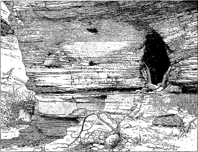
Plate L. Doorway to Cavate Lodge.
Since the American occupancy of the country and the consequent removal of the hostile pressure which has kept the Pueblo tribes in check, development has been rapid and now threatens a speedy extinction of pueblo life. The old Laguna has been abandoned, Acoma is being depopulated, the summer pueblos of Zuñi are now occupied all the year round by half a dozen or more families, and even in Tusayan, the most conservative of all the pueblo groups, the abandonment of the home village and location in more convenient single houses has commenced. It is the old process over again, but with the difference that formerly the cycle was completed by the reaggregation of the various families, and little bands into larger groups under hostile pressure from wilder tribes, but now that pressure has been permanently removed, and in a few years, or at most in a few generations, the old pueblo life will be known only by its records.
Footnotes
INDEX
Acoma, Abandonment of 261
—, Kivas in 257
—, Selection of site of 215
Adobe, Absence of, in Verde ruins 187, 257
— construction of modern introduction 238
—, Limit to use of 238
Age of cavate lodges 225
— — Verde ruins 209, 257
Agriculture, Ancient, in Verde valley 247
Anawita, Tusayan tradition by 188
Apache, Effect of, on pueblo tribes 260
Architecture of ancient Verde pueblos 185
Bandelier, A. F., on ancient pueblo population 259
Basketry in cavate lodges 228
Beaver Creek cliff ruin, Description of 186
Bone implements in cavate lodges 223, 224
Bowlders, ancient pueblo walls of 206, 217, 246, 249
— on line of ancient irrigating ditch 244
—, Sites marked by, in Verde valley 194, 235, 261
Brush, Structures of, discussed 237
Camp Verde established and abandoned 185
Canyon de Chelly, Cliff dwellings in 254
—, Kivas in 257
Casa Grande, Character of structure of 238
— and San Juan ruins compared 186
Cavate lodges, Ancient, how excavated 251
— described and figured 217
— in Verde valley 187, 192
— on Fossil creek 203
—, Reason for abundance of 260
Cave dwellings in Arizona 224
Chaco ruins and Casa Grande compared 186
Chimneys, Absence of, in Verde cavate lodges 187, 256, 257
Chinking of walls 248
Ci-pa, an ancient Hopi stopping place 189
Cists. See Storage cist; Water pocket
Cliff dwellings, Absence of, in Verde valley 187, 260
— in Arizona 224
— why constructed 260
—. See Cavate lodge.
Corn found in cavate lodges 225
Courts in ancient Verde ruins 196
—. See Plaza.
Cushing, F. H., on depressed structures in Arizona 245
Debris, Height of ancient villages judged by 198, 240
Defensive motive of cliff dwellings 260
— sites of ancient Verde villages 193, 206, 208, 214, 215, 216
De Forest, J. W., on Connecticut indian spades 183
Diller, J. S., on formation in which cavate lodges occur 219
Dimensions of ancient pueblos 211
Doorways in cavate lodges 222, 251
Espejo, A. de, Expedition of, in 1583 185
Farfan, M, Visit of, to Arizona in 1598 185
Fiber Bundles of, in cavate lodges 228
Fireholes in ancient Arizona structures 232, 246
Fireplace in cavate lodges 224, 256
Flagstaff, Ariz., Cavate lodges near 217, 223
Floors plastered for leveling 251
Freshet, Effect of, on ancient Verde irrigating ditch 240
— in Rio Verde 191
Gardens of cavate village 224
Gentes, Aggregation, of, in villages 195
Granaries, Pima, how formed 246
Ground-plan, how affected by long occupancy 212
Havasupai cavate lodges 224, 225
Hawikuh, Mission established at 229
Height of ancient Verde pueblos 209
Hoffman, W. J., on Beaver creek cliff ruin 186
— on Montezuma well 186
Holmes, W. H., on San Juan cavate lodges 222
Homolobi, an ancient Hopi village 189
Hopi, Canyon de Chelly ruins attributed to the 257
Horn implements in cavate lodges 224
Horticulture, Ancient, on Rio Verde 187, 194, 238
Implements in cavate lodges 224, 228
Irrigation ditches in Verde valley 194, 237-238
Jacal structures 237
Kiva architecture, Evolution of 257
— circular, Absence of, in Verde cavate lodges 257
— in Verde ruins 196
Laguna, Abandonment of 261
Leroux, ——, Ruins in Verde valley mentioned by 186
Mancos river, Cavate lodges on 222
Marriage custom of the pueblos 197
Masonry of ancient Verde villages 201, 203, 204, 212, 248, 259
— — cavate lodges 225
Mearns, E. A., on Verde ruins 186
Metates in cavate lodges 223
Migration, Pueblo, how effected 258
— tradition of the Hopi 188
Military art of ancient pueblos 215
Mindeleff, V., on notched doorways 254
— on pueblo kivas 257
Montezuma well described 186
Mortar, Excessive use of, in ancient villages 249
Navajo, Effect of, on pueblo tribes 260
—, Hogan construction by the 237
Nelson, E. W., on certain ruined pueblo features 202
Nutria, a Zuñi summer village 206, 261
Ojo Caliente, a Zuñi summer village 206, 261
Oñate, Juan de, Expeditions of 185
Oraibi, Architectural character of 195
Oven in cavate lodge 226
Palat-kwabi, a Hopi stopping place 189
Pálü-lü-koña, the Hopi serpent deity 188
Passageway in cavate lodge 222, 225, 227, 231, 232, 235
—, Absence of, in Verde ruins 199
Pat-Ki-Nyûmû, the Hopi water-house phratry 188
Pescado, a Zuñi summer village 206, 261
Pima, Granaries of the 246
Pisé construction in Arizona 238
Plastering in Verde cavate lodges 222, 225, 251
Plaza in cavate village 223
—. See Court.
Population of ancient cavate lodges 251
— — pueblos 203, 211, 259
Potsherds around cavate lodges 224
— in cavate lodges 228
— in Verde ruins 213, 217
— on bowlder-marked sites 235
—, Cavate fireplace lined with 256
Powell, J. W. on Arizona cavate lodges 223
— — Santa Clara cavate lodges 224
Prescott, Arizona, Mines discovered near 185
—, Visit of Espejo to vicinity of 185
Quesada, A. de, Visit of, to Arizona 185
Rainfall in Verde valley 245
Reservoir, ancient, Traces of 236, 237
—, Depression like, in Verde valley 245
Roof timbers, Source of, in Verde valley 196
Rooms, Arrangement of, in cavate lodges 220, 221, 229
—, Detached, in Verde ruins 198
—, Distribution of, in ancient villages 197, 210
—, Size of, in ancient villages 198, 210
Ruins, Extent of, in the southwest 259
— of Verde valley 185
Sandal in cavate lodges 228
San Francisco, early name of Rio Verde 186
— Mountain, Cavate lodges near 217, 223, 225
San Juan river, Cavate lodges on 222
Santa Clara, Cavate lodges near 217, 224
—, Ancient pueblos of 225
Site of cavate lodges 219
—, Selection of, of ancient villages 215
Sitting stones in ancient Arizona structures 246
Springerville, N. Mex., Ruins at 202
Stephen, A. M., Tusayan tradition obtained by 188
Stepping-stones to cavate lodge 253
Stevenson, JAS., Cavate lodges visited by 223
Stone implements in cavate lodges 223, 224
Storage cist described and figured 221, 250
— room in cavate lodge 228, 229
Summer village, Ruins of, on Rio Verde 206
Tags, Architectural character of 195
—, Defensive character of 215
Textile fabrics in cavate lodges 228
Thrashing floors in Verde valley 246
Tradition of Hopi water-people 188
Tsegi. See Canyon de Chelly.
Tusayan, Primitive architecture of 261
—, Kivas in 257
—, Notched doorways in 254, 255
—, Occupancy of Verde valley by the 188
—, Water gentes of the 188
—. See Hopi.
Vargas, diego de, New Mexico reconquered by 231
Verde river, Former name of 186
— Valley, Aboriginal remains in 185-261
Villages, Ancient, in Verde valley 192
Walapai and Havasupai affinity 224
—, Effect of, on pueblo tribes 260
— tradition of cavate lodges 225
Walls, Ancient pueblo, how built 248
—, Carved, in ancient ruins 202
—, Defensive, in Verde ruins 202, 203
—, Massive, in Verde ruin 199
Water people of Tusayan probably from south 188
— pockets in cavate lodge 228, 235
— storage in ancient Verde pueblo 199
Window-openings of cavate lodges 222, 251
Women, House building by 197
Wood, Implements of, in cavate lodges 224
Zuñi, Adoption of site of 215, 259
—, Defensive character of 215
—, Kivas in 257
—, Population of 195