ABORIGINAL REMAINS IN VERDE VALLEY, ARIZONA
Reading edition
By Cosmos Mindeleff
INTRODUCTION.
THE REGION AND ITS LITERATURE.
The region described in the following pages comprises the valley of the Rio Verde, in Arizona, from Verde, in eastern central Yavapai county, to the confluence with Salt river, in Maricopa county.
The written history of the region treated extends back only a few years. Since the aboriginal inhabitants abandoned it, or were driven from it, the hostile Apache and Walapai roamed over it without hindrance or opposition, and so late as twenty-five years ago, when the modern settlement of the region commenced, ordinary pursuits were almost impossible. Some of the pioneer settlers are still in possession, and are occupying the ground they took up at the time when the rifle was more necessary for successful agriculture than the plow.
The first notice of this region is derived from the report of Espejo, who visited some “mines” north and east of the present site of Prescott early in 1583; in 1598 Farfan and Quesada of Oñate’s expedition visited probably the same locality from Tusayan, and in 1604 Oñate crossed the country a little way north of the present Prescott, in one of his journeys in search of mineral wealth. Nothing seems to have come of these expeditions, however, and the remoteness of the region from the highways of travel and its rough and forbidding character caused it to remain unknown for over two centuries. It was not until the active prospecting for gold and silver accompanying the American invasion and conquest began that the country again became known. Valuable mines were discovered east and south of the site of Prescott, some of them as early as 1836; but it was not until after 1860 that any considerable amount of work was done, and the mining development of this region, now one of the best known in Arizona, may be said to date from about 1865. Camp Verde was first established in 1861, at a point on the northern side of Beaver creek, but was not regularly occupied until 1866. In 1871 it was removed to its present location, about a mile south of the previous site. It was abandoned as a military post in 1891, and gradually lost the military element of the name.
1 The descriptions are slight and do not touch the region herein discussed.
The first publication of importance to the present inquiry is a short paper by Dr. E. A. Mearns, U.S. Army, in the Popular Science Monthly for October, 1890. Dr. Mearns was stationed for some years at Camp Verde, and improved the opportunity afforded by numerous hunting expeditions and tours of duty to acquaint himself with the aboriginal remains of the Verde valley. He published a map showing the distribution of remains in that region, described several ruins in detail, and illustrated some pieces of pottery, etc., found by him. The article is unfortunately very short, so short that it is hardly more than an introduction to the wide field it covers; it is to be hoped that Dr. Mearns will utilize the material he has and publish a more comprehensive report.
The remains in the valley of Rio Verde derive an additional interest from their position in the ancient pueblo region. On the one hand they are near the southwestern limit of that region, and on the other hand they occupy an intermediate position between the ruins of the Gila and Salt river valleys and those of the northern districts. The limits of the ancient pueblo region have not yet been defined, and the accompanying map (plate X) is only preliminary. It illustrates the limited extent of our knowledge of the ancient pueblo region as well as the distribution of ruins within that region, so far as they are known; and the exceptional abundance of ruins noted on certain portions of the map means only that those parts are better known than others. Notwithstanding its incompleteness, it is the best available and is published in the hope that it will serve as a nucleus to which further data may be added until a complete map is produced.
The ruins in the Gila valley, including those along Salt river, are less known than those farther northward, but we know that there is a marked difference between the type exemplified by the well-known Casa Grande, near Florence, Arizona, and that of which the best specimens (notably the Chaco ruins) are found in the San Juan basin. This
Although the examination of this region failed to connect the northern and southern types of house structure, the peculiar conditions here are exceptionally valuable to the study of the principles and methods of pueblo building. Here remains of large villages with elaborate and complex ground plan, indicating a long period of occupancy, are found, and within a short distance there are ruins of small villages with very simple ground plan, both produced under the same environment; and comparative study of the two may indicate some of the principles which govern the growth of villages and whose result can be seen in the ground plans. Here also there is an exceptional development of cavate lodges, and corresponding to this development an almost entire absence of cliff dwellings. From the large amount of data here a fairly complete idea of this phase of pueblo life may be obtained. This region is not equal to the Gila valley in data for the study of horticultural methods practiced among the ancient Pueblos, but there is enough to show that the inhabitants relied principally and, perhaps, exclusively on horticulture for means of subsistence, and that their knowledge of horticultural methods was almost, if not quite, equal to that of their southern neighbors. The environment here was not nearly so favorable to that method of life as farther southward, not even so favorable as in some northern districts, and in consequence more primitive appliances and ruder methods prevailed. Added to these advantages for study there is the further one that nowhere within this region are there any traces of other than purely aboriginal work; no adobe walls, no chimneys, no constructive expedients other than those which may be reasonably set down as aboriginal; and, finally, the region is still so little occupied by modern settlers that, with the exception of the vicinity of Verde, the remains have been practically undisturbed. A complete picture of aboriginal life during the occupancy of the lower Verde valley would be a picture of pueblo life pursued in the face of great difficulties, and with an environment so unfavorable that had the occupation extended over an indefinite period of time it would still have been impossible to develop the great structures which resulted from the settlements in Chaco canyon.
We did not come direct to this region (Tusayan)—we had no fixed intention as to where we should go.
We are the Pat-ki-nyû-mû, and we dwelt in the Pa-lát-kwa-bĭ (Red Land) where the kwá-ni (agave) grows high and plentiful; perhaps it was in the region the Americans call Gila valley, but of that I am not certain. It was far south of here, and a large river flowed past our village, which was large, and the houses were high, and a strange thing happened there.
Our people were not living peaceably at that time; we were quarreling among ourselves, over huts and other things I have heard, but who can tell what caused their quarrels? There was a famous hunter of our people, and he cut off the tips from the antlers of the deer which he killed and [wore them for a necklace?] he always carried them. He lay down in a hollow in the court of the village, as if he had died, but our people doubted this; they thought he was only shamming death, yet they covered him up with earth. Next day his extended hand protruded, the four fingers erect, and the first day after that one finger disappeared [was doubled up?]; each day a finger disappeared, until on the fourth day his hand was no longer visible.
The old people thought that he dug down to the under world with the horn tips.
On the fifth day water spouted up from the hole where his hand had been and it spread over everywhere. On the sixth day Pá-lü-lü-koña (the Serpent deity) protruded from this hole and lifted his head high above the water and looked around in every direction. All of the lower land was covered and many were drowned, but most of our people had fled to some knolls not far from the village and which were not yet submerged.
When the old men saw Pá-lü-lü-koña they asked him what he wanted, because they knew he had caused this flood; and Pá-lü-lü-koña said, “I want you to give me a youth and a maiden.”
The elders consulted, and then selected the handsomest youth and fairest maid and arrayed them in their finest apparel, the youth with a white kilt and paroquet plume, and the maid with a fine blue tunic and white mantle. These children wept and besought their parents not to send them to Pá-lü-lü-koña, but an old chief said, “You must go; do not be afraid; I will guide you.” And he led them toward the village court and stood at the edge of the water, but sent the children wading in toward Pá-lü-lü-koña, and when they reached the center of the court where Pá-lü-lü-koña was the deity and the children disappeared. The water then rushed down after them, through a great cavity, and the earth quaked and many houses tumbled down, and from this cavity a great mound of dark rock protruded. This rock mound was glossy and of all colors; it was beautiful, and, as I have been told, it still remains there.
The White Mountain Apache have told me that they know a place in the south where old houses surround a great rock, and the land in the vicinity is wet and boggy.
We traveled northward from Palat-kwabi and continued to travel just as long as any strength was left in the people—as long as they had breath. During these journeys we would halt only for one day at a time. Then our chief planted corn in the morning and the pá-to-la-tei (dragon fly) came and hovered over the stalks and by noon the corn was ripe; before sunset it was quite dry and the stalks fell over, and whichever way they pointed in that direction we traveled.
When anyone became ill, or when children fretted and cried, or the young people became homesick, the Co-i-yal Katcina (a youth and a maiden) came and danced before them; then the sick got well, children laughed, and sad ones became cheerful.
We would continue to travel until everyone was thoroughly worn out, then we would halt and build houses and plant, remaining perhaps many years.
One of these places where we lived is not far from San Carlos, in a valley, and another is on a mesa near a spring called Coyote Water by the Apache. ***
When we came to the valley of the Little Colorado, south of where Winslow now is, we built houses and lived there; and then we crossed to the northern side of the valley and built houses at Homolobi. This was a good place for a time, but a plague of flies came and bit the suckling children, causing many of them to die, so we left there and traveled to Ci-pa (near Kuma spring).
Finally we found the Hopi, some going to each of the villages except Awatobi; none went there.
PHYSICAL DESCRIPTION OF THE COUNTRY.
The Rio Verde is throughout its length a mountain stream. Rising in the mountains and plateaus bounding two great connected valleys northwest of Prescott, known as Big Chino valley and Williamson valley, both over 4,000 feet above the sea, it discharges into Salt river about 10 miles south of McDowell and about 25 miles east of Phoenix, at an elevation of less than 1,800 feet above the sea. The fall from Verde to McDowell, a distance of about 65 miles, is about 1,500 feet The whole course of the river is but little over 150 miles. The small streams which form the river unite on the eastern side of Big Chino valley and flow thence in a southerly and easterly direction until some 12 miles north of Verde the waterway approaches the edge of the volcanic formation known on the maps as the Colorado plateau, or Black mesa, and locally as “the rim.” Here the river is sharply deflected southward, and flows thence in a direction almost due south to its mouth. This part of the river is hemmed in on both sides by high mountain chains and broken every few hundred yards by rapids and “riffles.”
Its rapid fall would make the river valuable for irrigation if there were tillable land to irrigate; but on the west the river is hugged closely by a mountain chain whose crest, rising over 6,000 feet above the sea, is sometimes less than 2 miles from the river, and whose steep and rugged sides descend in an almost unbroken slope to the river bottom. The eastern side of the river is also closely confined, though
Most of the modern settlements of the Rio Verde are along the upper portion of its course. Prescott is situated on Granite creek, one of the sources of the river, and along other tributaries, as far down as the southern end of the great valley in whose center Verde is located, there are many scattered settlements; but from that point to McDowell there are hardly a dozen houses all told. This region is most rugged and forbidding. There are no roads and few trails, and the latter are feebly marked and little used. The few permanent inhabitants of the region are mostly “cow men,” and the settlements, except at one point, are shanties known as “cow camps.” There are hundreds of square miles of territory here which are never visited by white men, except by “cow-boys” during the spring and autumn round-ups.
Scattered at irregular intervals along both sides of the river are many benches and terraces of alluvium, varying in width from a few feet to several miles, and comprising all the cultivable land in the valley of the river. Since the Verde is a mountain stream with a great fall, its power of erosion is very great, and its channel changes frequently; in some places several times in a single winter season. Benches and terraces are often formed or cut away within a few days, and no portion of the river banks is free from these changes until continued erosion has lowered the bed to such a degree that that portion is beyond the reach of high water. When this occurs the bench or terrace, being formed of rich alluvium, soon becomes covered with grass, and later with mesquite and “cat-claw” bushes, interspersed with such cottonwood trees as may have survived the period when the terrace was but little above the river level. Cottonwoods, with an occasional willow, form the arborescent growth of the valley of the Verde proper, although on some of the principal tributaries and at a little distance from the river groves of other kinds of trees are found. All these trees, however, are confined to the immediate vicinity of the river and those of its tributaries which carry water during most of the year; and as the mountains which hem in the valley on the east and west are not high enough to support great pines such as characterize the plateau country on the north and east, the aspect of the country, even a short distance away from the river bottom, is arid and forbidding in the extreme.
Within the last few years the character of the river and of the country adjacent to it has materially changed, and inferences drawn from
Owing to the character of the country it drains, the Rio Verde always must have been subject to freshets and overflows at the time of the spring rains, but until quite recently the obstructions to the rapid collection of water offered by thickly growing grass and bushes prevented destructive floods, except, perhaps, on exceptional occasions. Now, however, the flood of each year is more disastrous than that of the preceding year, and in the flood of February, 1891, the culminating point of intensity and destructiveness was reached. On this occasion the water rose in some places over 20 feet, with a corresponding broadening in other places, and flowed with such velocity that for several weeks it was impossible to cross the river. As a result of these floods, the grassy banks that once distinguished the river are now but little more than a tradition, while the older terraces, which under normal circumstances would now be safe, are being cut away more and more each year. In several localities near Verde, where there are cavate lodges, located originally with especial reference to an adjacent area of tillable land, the terraces have been completely cut away, and the cliffs in which the cavate lodges occur are washed by the river during high water.
DISTRIBUTION AND CLASSIFICATION OF RUINS.
All the modern settlements of the lower portion of the Verde valley are located on terraces or benches, and such localities were also regarded favorably by the ancient builders, for almost invariably where a modern settlement is observed traces of a former one will also be found. The former inhabitants of this region were an agricultural people, and their villages were always located either on or immediately adjacent to some area of tillable soil. This is true even of the cavate lodges, which are often supposed to have been located solely with reference to facility of defense. Owing to the character of the country, most of the tillable land is found on the eastern side of the river, and as a consequence most of the remains of the former inhabitants are found there also, though they are by no means confined to that side. These remains are quite abundant in the vicinity of Verde, and less so between that point and the mouth of the river. The causes which have induced American settlement in the large area of bottom land about Verde doubtless also induced the aboriginal settlement of the same region, although, owing to the different systems of agriculture pursued by the two peoples, the American settlements are always made on the bottom lands themselves, while the aboriginal settlements are almost always located on high ground overlooking the bottoms. Perched on the hills overlooking these bottoms, and sometimes located on the lower levels, there was once a number of large and important villages, while in the regions on the south, where the tillable areas are as a rule very much smaller, the settlements were, with one exception, small and generally insignificant. The region treated in these pages is that portion of the valley of Rio Verde comprised between its mouth and Verde, or Beaver creek, on the north. It was entered by the writer from the south; it is not proposed, however, to follow a strict geographic order of treatment, but, on the contrary, so far as practicable, to follow an arrangement by types.
The domiciliary ruins of this region fall easily into three general classes, to which may be added a fourth, comprising irrigating ditches and works, the first class having two subclasses. They are as follows:
Stone villages.
a. Villages on bottom lands.
b. Villages on defensive sites.
Cavate lodges.
Bowlder-marked sites.
Irrigating ditches and works.
The ruins of the second subclass, or stone villages located on defensive sites, are found throughout the whole of this region, although the type reaches its best development in the northern portion, in the vicinity of Verde. The separation of this type from the preceding one is to a certain extent arbitrary, as the location of a ruin is sometimes determined solely by convenience, and convenience may dictate the selection of a high and defensible site, when the tillable land on which the village depends is of small area, or when it is divided into a number of small and scattered areas; for it was a principle of the ancient village-builders that the parent village should overlook as large an extent as possible of the fields cultivated by its inhabitants. A good illustration of this type of ruin is found a little way northeast of Verde, on the opposite side of the river. Here a cluster of ruins ranging from small groups of domiciles to medium-sized villages is found located on knobs and hills, high up in the foothills and overlooking large areas of the Verde bottom lands. These are illustrated later. Another example, also illustrated later, occurs on the eastern side of the river about 8 miles north of the mouth of Fossil creek. The village, which is very small, occupies the whole summit of a large rock which projects into the stream, and which is connected with the mainland by a natural causeway or dike. This is one of the best sites for defense seen by the writer in an experience of many years.
Cavate lodges are distributed generally over the whole northern portion of the region here treated. At many points throughout this region there are outcrops of a calcareous sandstone, very soft and strongly laminated and therefore easily excavated. This formation often appears in the cliffs and small canyons bordering on the streams, and in it are found the cavate lodges. The best examples are found some 8 miles south of Verde, in a small canyon on the eastern side of the river, and it
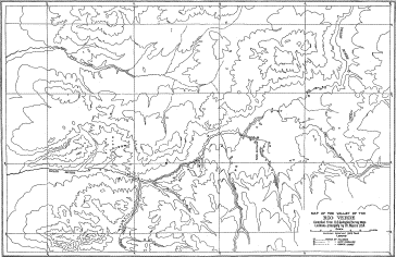
Plate XI. Map of the Valley of the Rio Verde. larger view
Bowlder-marked sites are scattered over the whole region here treated although they are more abundant in the southern part than in the northern. They are so abundant that their locations could not be indicated on the accompanying map (plate XI). These constitute a peculiar type, not found elsewhere in the experience of the writer, and present some points of interest. They vary in size from one room to considerable settlements, but the average size is two or three rooms. They are always located with reference to some area, generally a small one, of tillable land which they overlook, and all the data now available support the inference that they mark the sites of small farming or temporary shelters, occupied only during the farming season and abandoned each winter by the inhabitants, who then return to the main pueblo—a custom prevalent today among the pueblos. These sites are found on the flat bottom lands of the river, on the upper terraces overlooking the bottoms, on points of the foothills, in fact everywhere where there is an area of tillable land large enough to grow a few hills of corn. They often occur in conjunction with irrigating ditches and other horticultural works; sometimes they are located on small hillocks in the beds of streams, locations which must be covered with water during the annual floods; sometimes they are found at the bases of promontories bordering on drainage channels and on the banks of arroyas, where they might be washed away at any time. In short, these sites seem to have been selected without any thought of their permanency.
Irrigating ditches and horticultural works were found in this region, but not in great abundance; perhaps a more careful and detailed examination would reveal a much larger number than are now known. Fine examples of irrigating ditches were found at the extreme northern and the extreme southern limits of the region here treated, and there is a fair presumption that other examples occur in the intermediate country. These works did not reach the magnitude of those found in the Gila and Salt river valleys, perhaps partly for the reason that the great fall of Verde river and its tributaries renders only short ditches necessary to bring the water out over the terraces, and also partly because irrigation is not here essential to successful horticulture. In good years fair crops can be obtained without irrigation, and today this method of farming is pursued to a limited extent.
PLANS AND DESCRIPTIONS.
STONE VILLAGES.
Ruins of villages built of stone, either roughly dressed or merely selected, represent the highest degree of art in architecture attained by the aborigines of Verde valley, and the best example of this class of ruin is found on the eastern side of the river, about a mile above the mouth of Limestone creek. The site was selected without reference to defense, and is overlooked by the hills which circumscribe a large semicircular area of bottom land, on the northern end of which the village was located. This is the largest ruin on the Verde; it covers an area of about 450 feet square, or over 5 acres, and has some 225 rooms on the ground plan. From the amount of debris we may infer that most of the rooms were but one story in height; and a reasonable estimate of the total number of rooms in the village when it was occupied would make the number not greater than 300 rooms. The ratio of rooms to inhabitants in the present pueblos would give a population for this village of about 450 persons. Zuñi, the largest inhabited pueblo, covering an area of about 5 acres, has a population of 1,600.
It will thus be seen that, while the area covered by this village was quite large, the population was comparatively small; in other words, the dense clustering and so-called beehive structure which characterize Zuñi and Taos, and are seen to a less extent in Oraibi, and which result from long-continued pressure of hostile tribes upon a village occupying a site not in itself easily defensible, has not been carried to such an extent here as in the examples cited. But it is also apparent that this village represents the beginning of the process which in time produces a village like Zuñi or Taos.
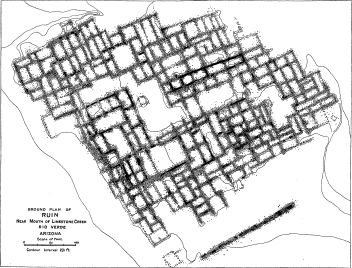
Plate XII. Ground Plan of Ruin Near Mouth of Limestone Creek Rio Verde, Arizona larger view
Plate XII exhibits the ground plan of the village. It will be observed that this plan is remarkably similar in general characters to the ground plan of Zuñi.2 A close inspection will reveal the presence of many discrepancies in the plan, which suggest that the village received at various times additions to its population in considerable numbers, and was not the result of the gradual growth of one settlement nor the home of a large group coming en masse to this locality. It has been shown3 that in the old provinces of Tusayan and Cibola (Moki and Zuñi) the present villages are the result of the aggregation of many related gentes and subgentes, who reached their present location at different times and from different directions, and this seems to be the
The ground plan shows a number of courts or open spaces, which divided the village into four well-defined clusters. The largest court was nearly in the center of the village, and within it (as shown, on the plan) there are traces of a small single-room structure that may have been a kiva of sacred chamber. Attached to this main court and extending eastward is another court of considerable size, and connected with this second court at its eastern end there is another one almost square in plan and of fair size. West of the main court may be seen a small court opening into it, and north of this another square space separated from the main court by a single stone wall and inclosed on the other three sides by rooms. In addition to these there are two completely inclosed small courts in the center of the southwestern cluster, and another one of moderate size between the southwestern and southern clusters.
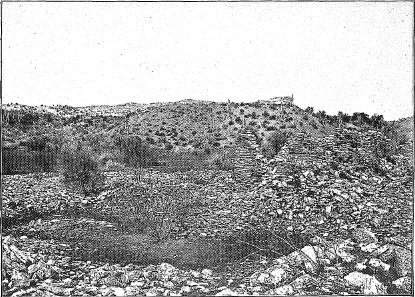
Plate XIII. Main Court, Ruin Near Limestone Creek.
The arrangement of these courts is highly suggestive. The central space was evidently the main court of the village at the time of its greatest development, and it is equally evident that it was inclosed at a later period than the small inclosed courts immediately adjacent to it, for had the latter not preceded it they would not occupy the positions they now do. Plate XIII represents a part of the main court, and beyond the débris can be seen a small portion of the bottom upon which the village is built. To the left, in the foreground of the illustration, are traces of a small detached room, perhaps the main kiva4 of the village; this is also shown on the ground plan, plate XII.
The smaller courts are but little larger than the largest rooms, but it will be noticed that while some of the rooms are quite large they are always oblong. This requirement was dictated by the length of available roofing timbers. The cottonwood groves on the river bank would provide timber of fair size but of very poor quality, and, aside from this, roofing timbers longer than 15 feet could be obtained only at points many miles distant. In either case the hauling of these timbers to the site of the village would be a work of great labor and considerable difficulty. The width of the rooms was, therefore, limited to about 20 feet, most of them being under 15 feet; but this limitation did not apply to the courts, which, though sometimes surrounded on all sides by buildings, were always open to the sky.
It is probable that the central and northern portion of the southwestern cluster comprised the first rooms built in this village. This is the portion which commands the best outlook over the bottom, and it is
The arrangement and distribution of the rooms within the clusters indicate an occupancy extending over a considerable period of time. A reference to the ground plan will show that continuous wall lines are the exception, and it is seldom that more than two or three rooms are grouped together in regular order. In irregularity of arrangement the inhabitants of this village followed a general habit, the result of which can be seen today in all the inhabited villages and in most of the large pueblo ruins. It indicates a steady growth of the village by the addition of rooms, one or two at a time, as they were needed. The division into clusters, however, indicates an aggregation of related gentes or subgentes banded together for protection. Given these conditions, (1) bands of related families living near one another; (2) hostile pressure from outside; and (3) a site not in itself easily defended, and a ground plan similar to the one under discussion must result. Single detached rooms would not be built when the village might be attacked at any time, but they might be added during periods of peace and, the conditions being favorable, they might form the nuclei of other clusters. It is possible that some of the clusters forming this village had their origin in this manner, but this question can not be determined from the ground plan, as a similar result would be produced by the advent of a small band of related families.
Growth in number of rooms does not necessarily indicate growth in population, and this qualification must not be lost sight of in the discussion of pueblo ground plans. Among the Pueblos of today, descent, in real property at least, is in the female line; when a man marries he becomes a member of his wife’s family and leaves his own home to live with his wife’s people. If the wife’s home is not large enough to contain all the members of the household, additional rooms are built adjoining and connected with those previously occupied. It may be mentioned in this connection that the women build the houses, although the men supply the material and do the heavy work. The result of this custom may be readily seen: a family in which there are many daughters must
It will be noticed that the size of rooms is more varied in the southwestern and southern clusters than in the remaining portions of the village. In the southwestern cluster rooms measuring 8 feet by 18 or 20 are not uncommon. These occur principally in the central and southwestern part of the cluster, while in the northern and northeastern part the rooms are uncommonly large, one of them measuring about 40 feet in length by nearly 15 feet in width and presenting a floor area of 600 square feet. Rooms approaching this size are more common, however, in the northern and northwestern clusters. In these latter clusters long narrow rooms are the exception and a number of almost square ones are seen. The smallest room in the village is in the center of the southern cluster, on the highest ground within the area covered by the ruin; it measures 6 feet by 10, with a floor area of 60 square feet, as opposed to the 600 square feet of the largest room. This small room was probably at one time a small open space between two projecting rooms, such as are often seen in the inhabited pueblos. Later the room on the south was built and the front of the space was walled up in order to make a rectangular area, thus forming the small room shown on the ground plan. The maximum length of any room is about 40 feet, the maximum width attained is about 20 feet, and in a general way it may be stated that the average size of the rooms is considerably larger than that of the rooms in the northern ruins.
From the regularity in distribution of the debris now on the ground, it appears that the rooms of the northwestern and northern clusters, including the eastern part of the village, were almost uniformly one story in height, and most of the rooms in the other clusters were also limited in height to a single story. The only places on the ground plan where rooms of two stories might have existed are the northern and central parts of the southwestern and southern clusters, and perhaps the southern side of the northern cluster; the last, however, being very doubtful.
In the scarcity of detached rooms or small clusters the plan of this village strongly resembles the ground plan of Zuñi. Only three detached rooms are seen in the plan. One of these, situated in the main or central court, has already been referred to as probably the remains of a kiva or sacred chamber. Another single room occurs outside of the village, near its southwestern corner. This was probably a dwelling room, for a kiva would hardly be located in this place.
The absence of clearly defined traces of passageways to the interior of the village is noticeable. This absence can hardly be attributed to the advanced state of decay in the ruin, for nearly all the wall lines can still be easily traced. At one point only is there a suggestion of an open passageway similar to those found in the inhabited pueblos. This occurs in the southeastern corner of the ground plan, between the southern cluster and the southern part of the northeastern cluster. It was about 25 feet long and but 6 feet wide in the clear. There were undoubtedly other passageways to the interior courts, but they were probably roofed over and perhaps consisted of rooms abandoned for that purpose. This, however, is anomalous.
There are several other anomalous features in the ground plan, the purposes of which are not clear. Prominent among them is a heavy wall extending about halfway across the southern, side of the village and at some distance from it. The total length of this wall is 164 feet; it is 4 feet thick (nearly twice the thickness of the other walls), and is pierced near its center by an opening or gateway 4 feet wide. The nearest rooms of the village on the north are over 40 feet away. This wall is now much broken down, but here and there, as shown on the plan, portions of the original wall lines are left. It is probable that its original height did not exceed 5 or 6 feet. The purpose of this structure is obscure; it could not have been erected for defense, for it has no defensive value whatever; it had no connection with the houses of the village, for it is too far removed from them. The only possible use of this wall that occurs to the writer is that it was a dam or retaining wall for a shallow pool of water, fed by the surface drainage of a small area on the east and northeast. There is at present a very slight depression between the wall and the first houses of the village toward the north—about a foot or a foot and a half—but there may have been a depression of 2 or 3 feet here at one time and this depression may have been subsequently filled up by sediment. This conjecture could be easily tested by excavating a trench across the area between the wall and the houses, but in the absence of such an excavation the suggestion is a mere surmise.
Another anomalous feature is found in the center of the southwestern cluster. Here, in two different rooms, are found walls of double the usual thickness, occurring, however, on only one or two sides of the rooms. These are clearly shown on the ground plan. The westernmost of the two rooms which exhibit this feature has walls of normal thickness on three of its sides, while the fourth or eastern side consists of two walls of normal thickness, built side by side, perhaps the result of some domestic quarrel. The eastern room, however, has thick walls
A ruin of the same general type as that just described, but much smaller in size, is found about 6 miles farther northward on the eastern side of the river. It is located on the river edge of a large semicircular flat or terrace, near its northern end, and is built of flat slabs of limestone and river bowlders. It is rectangular in plan and of moderate size. On the southern end of the same flat are two single-room rancher’s houses and a large corral. The rooms in this ruin are oblong and similar in size and arrangement to those just described.
About 11 miles above the last-described ruin, or 17 miles above the large ruin near Limestone creek, there is another small ruin of the same general type as the last, located on a similar site, and in all respects, except size, closely similar to it.
About 3 miles below the mouth of the East Verde there is still another ruin of similar character, located on the edge of a mesa or bench overlooking the river. It is built of bowlders and slabs of rock. Like the others this ruin is rectangular in plan and of small size.
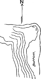
Fig. 279.—Sketch map, site of small ruin 10 miles north of Fossil creek.
About 10 miles north of the mouth of Fossil creek, on the point of a bench or terrace on the western side of the river, and perhaps 20 feet above it, occurs a small ruin, similar in character to the preceding. The river here makes a long turn eastward, then flows south again, and in the angle a small bench or terrace is formed. At this point the mountains rise abruptly from the river on both sides to a height of over a thousand feet. Fig. 279 illustrates the location of this ruin. So far as could be distinguished from the hills opposite, the rooms occur in two broken lines at right angles to each other.
These four small ruins are all closely similar to the large ruin described above in all respects except size, and peculiarities of ground plan attendant on size. The rooms are always rectangular, generally oblong, and arranged without regularity as regards their longer axis. Except the one last described, the ruins consist of compact masses of rooms, without evidences of interior courts, all of very small size, and all located without reference to defense. The last-described ruin differs from the others only in the arrangement of rooms. There is practically no standing wall remaining in any of them, and even now they can be seen for miles from the hills above. When the walls were
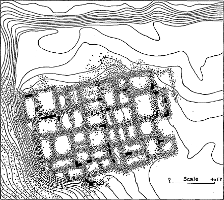
Fig. 280.—Ground plan of ruin at mouth of the East Verde.
On the southern side of the East Verde, half a mile above its mouth, a small creek comes in from the south, probably dry throughout most of the year; and on a promontory or point of land left by this creek a small ruin occurs. It is similar in plan and in character of masonry to those just described, and differs from them only in that its site is better adapted for defense, being protected on two sides by steep hills or cliffs. The ground plan of this ruin is shown in figure 280, and its general appearance in plate XIV, which also shows the character of masonry. The village overlooked a large area of low bottom land in the angle between the Verde and the East Verde, and is itself overlooked by the foothills rising behind it to the high mesas forming part of the Mazatzal mountains.
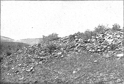
Plate XIV. Ruin at Mouth of the East Verde.
The walls of this village were built of flat bowlders and slabs of limestone, and there is now practically no standing wall remaining. The
On the southern side of the village the ground plan shows a bit of curved wall. It is doubtful whether this was an actual wall or merely a terrace. If it was a wall it is the only example of curved wall found in the region in ruins of this class. Between this wall or terrace and the adjoining wall on the north, with which it was connected, the ground is now filled in. Whether this filling occurred prior or subsequent to the abandonment of the village does not appear. The northeastern corner of the ruin is marked by a somewhat similar feature. Here there is a line of wall now almost obliterated and but feebly marked by debris, and the space between it and the village proper is partly filled in, forming a low terrace. Analogous features are found in several other ruins in this region, notably in the large ruin near Limestone creek. It should be noted in this connection that Mr. E. W. Nelson has found that places somewhat similar to these in the ruins about Springerville, New Mexico, always well repaid the labor of excavation, and he adopted as a working hypothesis the assumption that these were the burial places of the village. Whether a similar condition would be found in this region can only be determined by careful and systematic excavation.
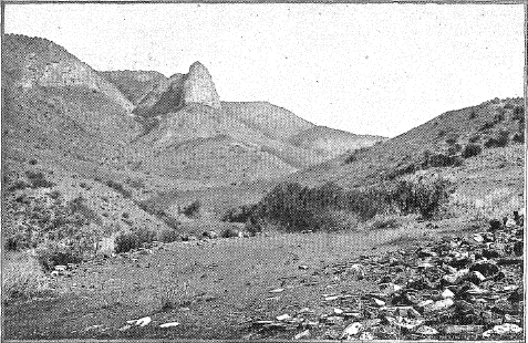
Plate XV. Main Court, Ruin at Mouth of the East Verde.
The village did not occupy the whole of the mesa point on which it is located; on the east the ground rises gently to the foothills of the Mazatzal range, and on the south and west it slopes sharply down to the little creek before mentioned; while on the north there is a terrace or flat open space some 60 feet wide and almost parallel with the longer axis of the village. This open space and the sharp fall which limits it on the north is shown on the ground plan. The general view of the same feature (plate XV) also shows the character of the valley of the East Verde above the ruin; the stream is here confined within a low walled canyon. This open space formed a part of the village and doubtless occupied the same relation to it that interior courts do to other villages. Its northern or outer edge is a trifle higher than the space between it and the village proper and is marked by several large bowlders and a small amount of debris. It is possible that at one time there was a defensive wall here, although the ground falls so suddenly that it is almost impossible to climb up to the edge from below without artificial
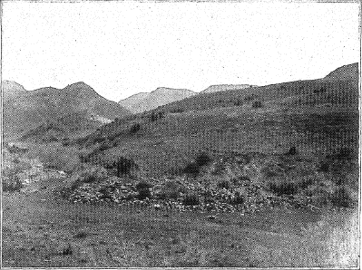
Plate XVI. Ruin at Mouth of Fossil Creek.
A comparison of the ground plan of this ruin and those previously described, together with that of the ruin near the mouth of Fossil creek (plate XVI), which is typical of this group, shows marked irregularity in outline and plan. In the character of the debris also this ruin differs from the Fossil creek ruin and others located near it. As in the latter, bowlders were used in the wall, but unlike the latter rough stone predominates. In the character of its masonry this ruin forms an intermediate or connecting link between the ruins near Limestone creek and opposite Verde and the class of which the ruin near the mouth of Fossil creek is typical. In the character of its site it is of the same class as the Fossil creek ruin, being intermediate between the valley pueblos, such as that near Limestone creek, and pueblos located on defensive sites, such as the group opposite Verde. The ground plan indicates an occupancy extending over a considerable period of time and terminating at or near the close of the period of aboriginal occupancy of the valley of Rio Verde.
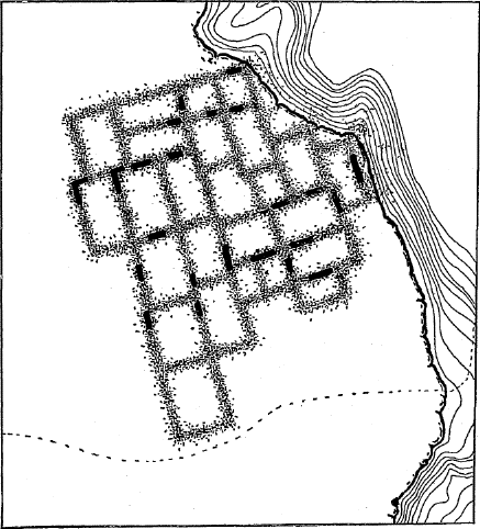
Fig. 281.—Ground plan of ruin near the month of Fossil creek.
Another ruin, of a type closely similar, occurs on a bluff near the mouth of Fossil creek. The plan of this ruin is shown in figure 281. The village is located close to the edge of the bluff, as shown in the plan, and has an outlook over a considerable area of bottom land adjoining the bluff on the east. It is probable that the cavate lodges whose location some 8 or 10 miles above the ruin, on Fossil creek, is shown on the general map (plate XI) were appendages of this village.
The wall still standing extends but a few inches above the débris, but enough remains to mark the principal wall lines, and these are farther emphasized by the lines of débris. The débris here is remarkably clean and stands out prominently from the ground surface, instead of being merged into it as is usually the case. This is shown in the general view of the ruin. There are twenty-five rooms on the ground plan, and there is no evidence that any of these attained a greater height than one story. The population, therefore, could not have been much, if any, in excess of forty, and as the average family of the Pueblos consists of five persons, this would make the number of families which found a home in this village less than ten. Notwithstanding this small population the ground plan of this village shows clearly a somewhat extended period of occupancy and a gradual growth in size. The eastern half of the village, which is located along the edge of the bluff, probably preceded the western in point of time. It will be noticed that while the wall lines are seldom continuous for more than three rooms, yet the rooms themselves are arranged with a certain degree of regularity, in that the longer axes are usually parallel.
The masonry of this village is almost entirely of flat bowlders, obtained probably from the bed of the creek immediately below. The terrace on which the village was built, and in fact all the hills about it are composed of gravel and bowlders, but it would be easier to carry the bowlders up from the stream bed than to quarry them from the hillside, and in the former case there would be a better opportunity for selection. Plate XVI shows the character of the rock employed, and illustrates the extent to which selection of rock has been carried. Although the walls are built entirely of river bowlders the masonry presents almost as good a face as some of the ruins previously described as built of slabs of limestone, and this is due to careful selection of the stone employed.
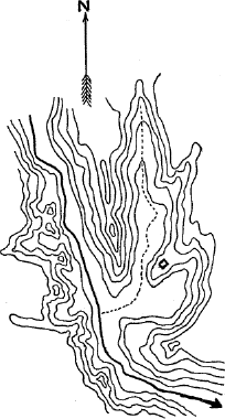
Fig. 282.—Sketch map, site of ruin above Fossil creek.
About half a mile above the mouth of Fossil creek, and on the eastern side of the river, a deep ravine comes in from the north and east,
About 8½ miles north of Fossil creek, on the eastern side of the Verde, occurs a small ruin, somewhat different in the arrangement of rooms from those described. Here there is a bench or terrace, some 50 feet above the river, cut through near its northern end by a small canyon. The ruin is located on the southern side of this terrace, near the mouth of the creek, and consists of about ten rooms arranged in L shape. The lines are very irregular, and there are seldom more than three rooms connected. The débris marking the wall lines is clean, and the lines are well defined, although no standing wall remains.
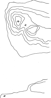
Fig. 283.—Sketch map of ruin 9½ miles above Fossil creek.
About a mile above the last-described ruin, or 9½ miles north of the mouth of Fossil creek, a small group of ruins occurs. The sketch, figure 283, shows the relation of the parts of this group to one another. The small cluster or rooms on the south is very similar in character, location, and size to the ruin last described. The northern portion is situated on the opposite side of a deep canyon or ravine, on the crown of a hill composed of limestone, which outcrops everywhere about it, and is considerably higher than the small cluster on the south. The northern ruin is of considerable size and very compactly built, the rooms being clustered about the summit of the hill. The central room, occupying the crown of the hill, is 20 feet higher than the outside rooms. In a saddle between the main cluster and a similar hill toward the southeast there are a number of other rooms, not marked so prominently by débris as those of the main cluster. There is no standing wall remaining, but the débris of the main and adjoining clusters indicates that the masonry was very rough, the walls being composed of slabs of limestone similar to those found in the large ruin near the mouth of Limestone creek, and obtained probably not 20 feet away from their present position.
The ruin described on page 200 and assigned to the first subclass occurs about half a mile north of this limestone hill, on the opposite side of the river. This small ruin, like all the smaller ruins described, was built of river bowlders, or river bowlders with occasional slabs of sandstone or limestone, while the ruin last described consists exclusively of limestone slabs. This difference is explained, however, by the character of the sites occupied by the several ruins. The limestone hill upon which the ruin under discussion is situated is an anomalous feature, and its occurrence here undoubtedly determined the location of this village. It is difficult otherwise to understand the location of this cluster of rooms, for they command no outlook over tillable land, although the view up and down the river is extensive. This cluster, which is the largest in size for many miles up and down the river, may have been the parent pueblo, occupying somewhat the same relation to the smaller villages that Zuñi occupies to the summer farming settlements of Nutria, Pescado, and Ojo Caliente; and doubtless the single-room remains, which occur above and below the cluster on mesa benches and near tillable tracts, were connected with it. This ruin is an example of the second subclass, or villages located on defensive sites, which merges into ruins of the first subclass, or villages on bottom lands, through villages like that located at the mouth of the East Verde and at the mouth of Fossil creek.
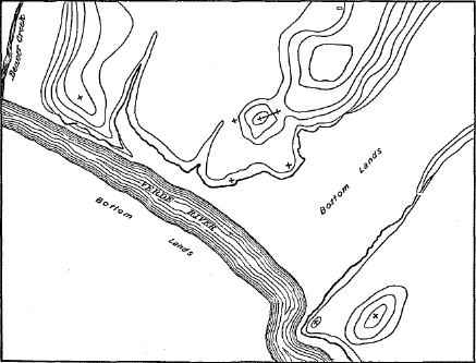
Fig. 284.—Sketch map showing location of ruins opposite Verde.
On the eastern side of the Verde, just below the mouth of Beaver creek, opposite and a little above Verde, occurs one of the best examples to be found in this region of a large village located on a defensive
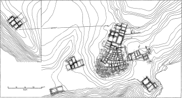
Plate XVII. Ground Plan of Ruins Opposite Verde. larger view
The principal ruin of the group is situated on the northern side of a small valley running eastward from the river up to the foot of a prominent mesa, which here bounds the eastern side of the river bottom. The valley is perhaps half a mile long and about an eighth of a mile wide. The ruin is located on a butte or knoll connected with the hills back of it by a low saddle, forming a sort of promontory or tongue of land rising from a flat space or bench, the whole some 200 feet above the river bottom. One of the clusters of rooms is located in the saddle mentioned and is connected with the main ruin. At the foot of the butte on the western side there is a similar cluster, not connected, however, with the main ruin; and south of the main ruin, on the extreme edge of the little mesa or bench, there is another small cluster. The ruin shown on the sketch map southwest of the main ruin consists of but two rooms, with no wall now standing. All these clusters are shown in their proper position on the ground plan, plate XVII. Plate XVIII, which is a general view from the east, shows the main ruin on the butte, together with the connected cluster east of it in the saddle. The modern settlement seen in the middle distance is Verde.
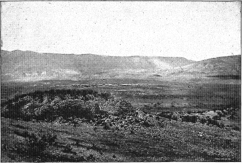
Plate XVIII. General View of Ruins Opposite Verde.
About a quarter of a mile west of the main ruin there is another small but well-preserved cluster of rooms. It occupies the narrow XVII, though not in its proper position. Northeast of this cluster and perhaps 200 yards distant there are traces of other rooms, but they are so faint that no plan can be made out. As shown on the sketch map, figure 284, the hill is a long narrow one, and its western side falls rapidly to a large triangular area of flat bottom land lying between it and Beaver creek, which it overlooks, as well as a large area of the valley up the river and all the fine bottom lands north and east of Verde and on the northwestern side of Beaver creek. As regards outlook, and also as regards security and facility of defense, the site of the small cluster is far superior to that of the main cluster of rooms.
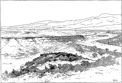
Plate XIX. Southern Part of Ruins Opposite Verde.
About a quarter of a mile south and east of the main ruin, on the opposite side of the little valley before mentioned, a mesa bench similar to the one last described occurs; and on a point of this, extending almost to the river bank, there are traces, now nearly obliterated, of a small cluster of rooms. A short distance east of this point there is a large rounded knoll, with a peculiar terrace-like bench at about half its height. The entire summit of this knoll was occupied by rooms, of which the walls are much broken and none remain standing. This knoll, with the ruins on its summit, is shown in plate XIX, which also gives a general view from the north of the small cluster southeast of the main ruin. The character of the valley of the Verde at this point is also shown. The sketch map, figure 284, shows the location of these ruins in reference to others of the group.
The main cluster, that portion occupying the crown or summit of the butte before described, exhibits at the present time some fifty rooms in the ground plan, but there were at one time a larger number than this; and there is no doubt that rooms extended down the slopes of the hill southward and southwestward. The plan of this main cluster is peculiar; it differs from all the smaller surrounding clusters. It tells the story of a long occupancy by a people who increased largely in numbers, but who, owing to their hostile environment, could not increase the space occupied by them in proportion to their numbers. It will be noticed that while the wall lines are remarkably irregular in arrangement they are more often continuous than otherwise, more frequently continuous, in fact, than the lines of some of the smaller villages before described. The rooms are remarkably small, 10 feet square being a not unusual measurement, and built so closely together as to leave no space for interior courts. The typical rooms in the ruins of this region are oblong, generally about twice as long as broad, measuring approximately 20 by 10 feet.
There is no evidence that any portion of this cluster attained a greater height than two stories, and only a small number of rooms reached that height. The small cluster adjoining on the north, and those on the southeast, southwest, and west, were built later and belong to the last period of the occupancy of the group. The builders exhibited a decided predilection for a flat site, as an examination of the sites of the various room clusters in the ground plan (plate XVII) will show, and when the sight of the main cluster became so crowded that additional rooms could be added only by building them on the sloping hillside, recourse was had to other sites. This tendency is also exhibited in the cluster adjoining the main cluster on the north, which was probably the second in point of age. The northern end of this small group of rooms terminates at the foot of the hill which rises northeastward, while a series of wall lines extends eastward at an angle with the lines of the cluster, but along the curve of the hillside.
The small northern cluster was in all probability inhabited by five or six families only, as contrasted with the main cluster, which had sixteen or seventeen, while the smaller clusters had each only two or three families. The strong presumption of the later building and occupancy of the smaller clusters, previously commented on, is supported by three other facts of importance, viz, the amount and height of the standing wall, the character of the sites occupied, and the extraordinary size of the rooms.
Although as a rule external appearance is an unsatisfactory criterion of age, still, other things equal, a large amount and good height of standing wall may be taken to indicate in a general way a more recent period of occupancy than wall lines much obliterated and merged into the surrounding ground level. The character of the site occupied is, however, a very good criterion of age. It was a rule of the ancient pueblo builder, a rule still adhered to with a certain degree of persistence, that enlargement of a village for the purpose of obtaining more space must be by the addition of rooms to those already built, and not by the construction of detached rooms. So well was this rule observed that attached rooms were often built on sites not at all adapted to them, when much better sites were available but a short
The tendency to cluster rooms in one large compact group was undoubtedly due primarily to hostile pressure from outside, and as this pressure decreased the inherent inconveniences of the plan would assert themselves and the rule would be less and less closely adhered to. It therefore follows that, in the absence of other sufficient cause, the presence of detached rooms or small clusters may be taken in a general way to indicate a more recent occupancy than a ground plan of a compact, closely built village.
The size of rooms is closely connected with the character of the site occupied. When, owing to hostile pressure, villages were built on sites difficult of access, and when the rooms were crowded together into clusters in order to produce an easily defended structure, the rooms themselves were necessarily small; but when hostile pressure from surrounding or outside tribes became less pronounced, the pueblo-builders consulted convenience more, and larger rooms were built. This has occurred in many of the pueblos and in the ruins, and in a general way a ruin consisting of large rooms is apt to be more modern than one consisting of small rooms; and where large and small rooms occur together there is a fair presumption that the occupancy of the village extended over a period when hostile pressure was pronounced and when it became less strong. It has already been shown that, owing to the social system of the pueblo-builders, there is almost always growth in a village, although the population may remain stationary in numbers or even decrease; so that, until a village is abandoned it will follow the general rule of development sketched above.
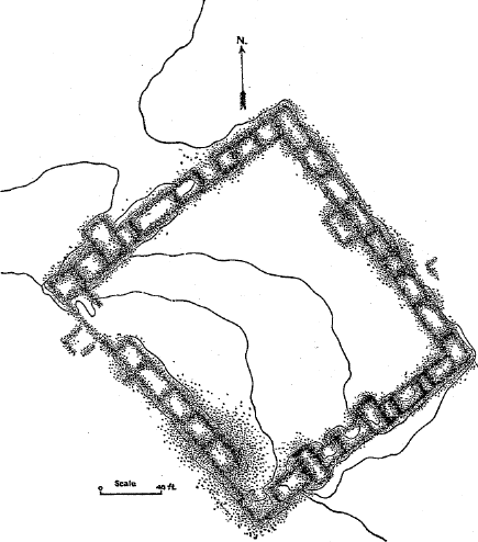
Fig. 285.—Ground plan of ruin on southern side of Clear creek.
Along the southern side of Clear creek, which discharges into the Rio Verde from the east, about 4 miles below Verde, there is a flat terrace from 30 to 40 feet above the creek and some 2 or 3 miles in length. Scattered over almost the whole of this terrace are remains of houses and horticultural works, which will be described later. Near the western end of the terrace a low hill with flat top and rounded sides rises, and on the top of this occurs the ruin whose ground plan is shown in figure 285.
This ruin commands an outlook over the whole extent of the terrace and seems to have been the home pueblo with which were connected the numerous single houses whose remains cover the terrace. The
It will be noticed that the wall lines are only approximately rectangular. The outside dimensions of the village are as follows: Northeastern side, 203 feet; southwestern, 207 feet; southeastern, 182 feet;
As already stated, long occupancy of a village, even without increase of population, produces a certain effect on the ground plan. This effect, so strongly marked in all the ruins already described, is conspicuous in this ruin by its almost entire absence. The ground plan is just such as would be produced if a small band of pueblo builders, consisting of ten or twelve related families, should migrate en masse to a site like the one under discussion and, after occupying that site for a few years—less than five—should pass on to some other location. Such migration and abandonment of villages were by no means anomalous; on the contrary, they constitute one of the most marked and most persistent phenomena in the history of the pueblo builders. If the general principles, already laid down, affecting the development and growth of ground plans of villages are applied to this example, the hypothesis suggested above—an incoming of people en masse and a very short occupancy—must be accepted, for no other hypothesis will explain the regularity of wall lines, the uniformity in size of rooms, and the absence of attached rooms which do not follow the general plan of the village. The latter is perhaps the most remarkable feature in the ground plan of this village. The addition of rooms attached irregularly at various points of the main cluster, which is necessarily consequent on long occupancy of a site, even without increase of population, was in this example just commenced. The result of the same process, continued over a long period of time, can be seen in the ground plan of any of the inhabited villages of today and in most of the ruins, while a plan like that of the ruin under discussion, while not unknown, is rare.
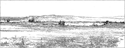
Plate XX. General View of Ruin on Southern Side of Clear Creek. larger view
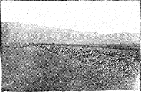
Plate XXI. Detailed View of Ruin on Southern Side of Clear Creek.
Plate XX, which is a general view of the ruin from the southwest, shows the character of the site and the general appearance of the debris, while plate XXI illustrates the character of the masonry. It will be noticed that the level of the ground inside and outside of the row of rooms is essentially the same; in other words, there has been no filling in. It will also be noticed that the amount of debris is small, and that it consists principally of rounded river bowlders. The masonry was peculiar, the walls were comparatively thin, and the lower courses were composed of river bowlders, not dressed or otherwise treated, while the upper courses, and presumably also the coping stones, were composed of slabs of sandstone and of a very friable limestone. The latter has disintegrated very much under atmospheric influences. The white
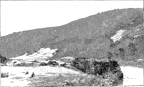
Plate XXII. General View of Ruin 8 Miles North of Fossil Creek.
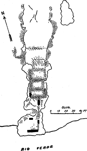
Fig. 286.—Ground plan of ruin 8 miles north of Fossil creek.
About 8 miles north of the mouth of Fossil creek, on the eastern side of the Verde, there is a ruin which, though very small, is interesting. At this point there is a long narrow mass of rock, the remains XXII, while the ground plan, figure 286, shows the character of the site. There were rooms on all that portion of the dike that stands out prominently from the ground level, and traces of other rooms can be seen on the ground level adjoining on the north and in the causeway resulting from the breaking down and disintegration of the dike. Remains of eight rooms in all can be traced, five of which were on the summit of the rock. The wall lines on the summit are still quite distinct and in places fragments of the original walls remain, as shown on the ground plan. The plan shows typical pueblo rooms of average size, and the masonry, though rough, is of the same character as that of other ruins in the vicinity.
Facility of defense undoubtedly had something to do with the choice of this location, but that it was not the only desideratum consulted is evident from the occurrence of a large area of fertile bottom land or flat river terrace immediately adjoining the ruin on the east and overlooked by it; in fact, the volcanic dike on which the ruin occurs occupies the western end of a large semicircular area of tillable land, such as already described. Viewed, however, as a village located with reference to defense it is the most perfect example—facility of obtaining water being considered—in this region. It may be used, therefore, to illustrate an important principle governing the location of villages of this type.
A study of the ground plan (figure 286) and the general view (plate XXII) will readily show that while the site and character of this village are admirably adapted for defense, so well adapted, in fact, as to suggest that we have here a fortress or purely defensive structure, still this adaptation arises solely from the selection of a site fitted by nature for the purpose, or, in other words, from an accident of environment. There has not been the slightest artificial addition to the natural advantages of the site.
The statement may seem broad, but it is none the less true, that, so far as our knowledge extends at the present time, fortresses or other purely defensive structures form a type which is entirely unknown in the pueblo region. The reason is simple; military art, as a distinct art, was developed in a stage of culture higher than that attained by the ancient pueblo builders. It is true that within the limits of the pueblo region structures are found which, from their character and the character of their sites, have been loosely described as fortresses, their describers losing sight of the fact that the adaptability of these structures to defense is the result of nature and not of art. Numerous examples are found where the building of a single short wall would double the defensive value of a site, but in the experience of the writer the
The first desideratum in the minds of the old pueblo builders in choosing the location of their habitations was nearness to some area of tillable land. This land was generally adjacent to the site of the village, and was almost invariably overlooked by it. In fact this requirement was considered of far more importance than adaptability to defense, for the latter was often sacrificed to the former. A good example in which both requirements have been fully met is the ruin under discussion. This, however, is the result of an exceptionally favorable environment; as a rule the two requirements conflict with each other, and it is always the latter requirement—adaptability to defense—which suffers. These statements are true even of the so-called fortresses, of the cavate lodges, of the cliff ruins, and of many of the large village ruins scattered over the southwestern portion of the United States. In the case of the large village ruins, however, there is another feature of pueblo life which sometimes produces a different result, viz, the use of outlying single houses or small clusters separated from the main village and used for temporary abode during the farming season only. This feature is well developed in some of the modern pueblos, particularly in Zuñi and Acoma.
The principle illustrated by this ruin is an important one. Among the ancient pueblo builders there was no military art, or rather the military art was in its infancy; purely defensive structures, such as fortresses, were unknown, and the idea of defense never reached any greater development than the selection of an easily defended site for a village, and seldom extended to the artificial improvement of the site. There is another result of this lack of military knowledge not heretofore alluded to, which will be discussed at length on some other occasion and can only be mentioned here: this is the aggregation of a number of small villages or clusters into the large many-storied pueblo building, such as the modern Zuñi or Taos.
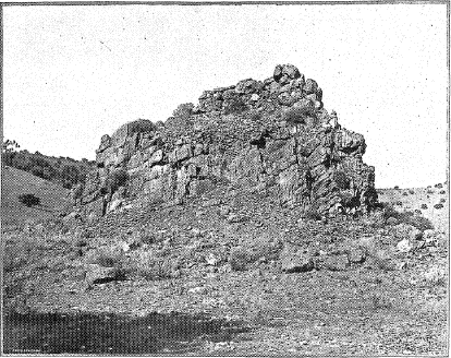
Plate XXIII. General View of Ruins on an Eminence 14 Miles North of Fossil Creek.
About 14 miles north of the mouth of Fossil creek, on the eastern side of the river, there is another ruin somewhat resembling the last described. A large red rock rises at the intersection of two washes, about a mile back from the river, and on a bench near the summit are the remains of walls. These are illustrated in plate XXIII. In general appearance and in character of site this ruin strongly resembles a type found in the San Juan region. There seem to have been only a few rooms on the top of the rock, and the prominent wall seen in the illustration was probably a retaining or filling wall in a cleft of the rock. Such walls are now used among the Pueblos for the sides of trails, etc. It is probable that at one time there were a considerable number of rooms on the rock; the debris on the ground at the base of the rock on the western side, shown in the illustration, is rather scanty; on the opposite or eastern side there is more, and it is not improbable there
It should be noted that this ruin, which is of a type known as “fortress” by some writers, is so placed as to command an extensive outlook over the large valley below and over the two small valleys above, as well as the considerable area of flat or bottom land formed by the junction of the small valleys. It is a type of a subordinate agricultural settlement, and had the defensive motive been entirely absent from the minds of the builders of this village it would undoubtedly have been located just where it now is, as this is the best site for an agricultural settlement for some distance up and down the river.
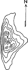
Fig. 287.—Sketch map of ruins on pinnacle 7 miles north of Fossil creek.
Remains of walls somewhat similar to these last described occur on a butte or pinnacle on the eastern side of the river and about 7 miles north of the mouth of Fossil creek. From the south this pinnacle is a most conspicuous landmark, rising as it does some 2,500 feet above the river within a distance of a quarter of a mile. The upper 50 feet of the eminence consists of bare red rock split into sharp points and little pinnacles, as shown in figure 287, which represents only the upper portion of the butte. The heavy black lines on the sketch map are walls. Some of these were doubtless mere retaining walls, but others are still standing to a considerable height, and there is yet much débris on the slope of the rock forming the eastern side of the butte near its top. It is doubtful whether these rooms were ever used for habitations, and more probable that they were used as a shrine or for some analogous purpose.
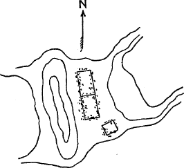
Fig. 288.—Remains of small rooms 7 miles north of Fossil creek.
Perhaps a quarter of a mile northeastward, in the saddle connecting the butte with the contiguous hills in that direction, there are remains of three small rooms, located east of a low swell or ridge. Figure 288
Half a mile northwestward, in a saddle similar to that last described, and east of the crown of a hill, are the remains of a single room, nearly square and perhaps 10 feet long. These single rooms and small cluster remains are unusual in this region, and seem to replace the bowlder-marked ruins so common south of the East Verde (to be described more fully later). Although the walls of this single-room structure were built of river bowlders, they are well marked by débris and are of the same type as those in the ruins at the mouths of the East Verde and Fossil creek.
CAVATE LODGES.
Cavate lodges comprise a type of structures closely related to cliff houses and cave dwellings. The term is a comparatively new one, and the structures themselves are not widely known. They differ from the cliff houses and cave dwellings principally in the fact that the rooms are hollowed out of cliffs and hills by human agency, being cut out of soft rock, while the former habitations are simple, ordinary structures built for various reasons within a cove or on a bench in the cliffs or within a cave. The difference is principally if not wholly the result of a different physical environment, i.e., cavate lodges and cave dwellings are only different phases of the same thing; but for the present at least the name will be used and the cavate lodges will be treated as a separate class.
There are but three regions in the United States in which cavate lodges are known to occur in considerable numbers, viz, on San Juan river, near its mouth; on the western side of the Rio Grande near the pueblo of Santa Clara; and on the eastern slope of San Francisco mountain, near Flagstaff, Arizona. To these may now be added the middle Verde region, from the East Verde to a point north of Verde, Arizona.
Within the middle Verde region there are thousands of cavate lodges, sometimes in clusters of two or three, oftener in small groups, and sometimes in large groups comprising several hundred rooms. One of these large groups, located some 8 miles south of Verde on the eastern side of the river, has been selected for illustration.
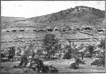
Plate XXIV. General View of Northern End of a Group of Cavate Lodges.
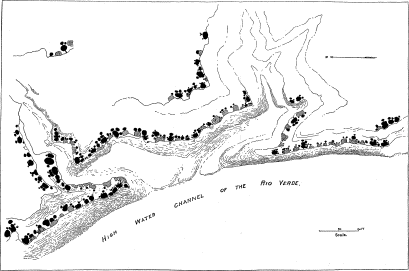
Plate XXV. Map of Group of Cavate Lodges in White Canyon, 3 Miles Below Clear Creek, East Side Rio Verde. larger view (red letters added by transcriber)
The bottom lands of the Rio Verde in the vicinity of Verde have been already described, and the cavate lodges in question occur just below the southern end of this large area of tillable land, and some of them overlook it. The river at this point flows southward, and extending toward the east are two little canyons which meet on its bank. North and south of the mouth of the canyons the bank of the XXIV shows the northern end of the group from a low mesa on the opposite side of the river; the eastern bank of the river can be seen in the foreground, while the sandy area extending to the foot of the bluff is the present high-water channel of the Verde. The map (plate XXV) shows the distribution of the cavate lodges composing the group, and plate XXVI shows the character of the site. The cavate lodges occur on two distinct levels—the first, which comprises nearly all the cavate lodges, is at the top of the slopes of talus and about 75 feet above the river; the second is set back from 80 to 150 feet from the first tier horizontally and 30 or 40 feet above it. The cavate lodges occur only in the face of the bluff along the river and in the lower parts of the two little canyons before mentioned. These canyons run back into the mesa seen in the illustration, which in turn forms part of the foothills rising into the range of mountains hemming in the Rio Verde on the east.
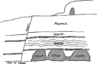
Fig. 289.—Diagram showing strata of canyon wall.
The walls of the canyon in the cavate-lodge area are composed of three distinct strata, clearly defined and well marked. The relations of the strata, at points on the northern and western sides of the north canyon, are shown in figure 289 and plate XXVI. The lowest stratum shown in the figure is that in which almost all the cavate lodges occur. It is about 8 feet thick and composed of a soft, very friable, purple-gray sandstone. Above it lies a greenish-white bed a few inches thick, followed by a stratum of a pronounced white, about 12 feet thick. This heavy stratum is composed of calcareous clay, and the green bed of a calcareous clay with a mixture of sand. The white stratum is divided at two-thirds its height by a thin belt of greenish-white rock, and above
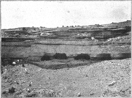
Plate XXVI. Strata of Northern Canyon Wall.
On the southern side of the canyon the lower purple stratum shows three distinct substrata; the upper is reddish purple and about 3½ feet thick, the middle is purple gray, about 7 feet thick, and apparently softer than the upper and lower strata. The lodges occur in the middle purple substratum, their floors composed of the upper surface of the lower stratum and their roofs of the under surface of the upper stratum. Those on the north side are similarly placed, their roofs being about 3 feet below the white, except that in several instances the upper part of the purple up to the white has fallen, making the cavity larger. This has occurred, however, since the abandonment of the caves, and the debris, still fresh looking, is in situ.
The formation in which the lodges occur is not of volcanic origin, although the beds composing it were perhaps deposited by hot springs during the period of great volcanic activity which produced San Francisco mountain in central Arizona and the great lava flows south of it. In view of the uncertainty on this point and the further fact that almost all the cavate lodges heretofore found were excavated in tufa, ash, or other soft volcanic deposits, the report of Mr. Joseph S. Diller, petrographer of the U.S. Geological Survey, will be of interest. It is as follows:
The coarse-grained specimen is sandstone, that of medium grain is argillaceous sandstone, and the fine-grained one is calcareous clay. The coarse-grained friable sandstone, in which the lodges have been excavated, consists chiefly of subangular and rounded grains of quartz and feldspar with a small proportion of black particles. Many of the latter are magnetite, while the others are hornblende and various ferromagnesian silicates. I did not detect any fragments of volcanic origin.
The specimen of argillaceous sandstone is made up of thin layers of fine-grained sand of the same sort as the first, alternating with others containing considerable clay. In the clay layers, a trace of carbonate of lime was found here and there, forming a transition of the calcareous clay.
The calcareous clay when placed in acid effervesces vigorously, but when allowed to stand the effervescence ceases in a few minutes and the insoluble white clay remains.
All the strata composing this formation are very soft; the purple-gray material of the middle layer is so soft that its surface can be rubbed off with the hand. They are also minutely stratified or laminated, and the laminæ are not well cemented together, so that a blow on the roof of a cavity with a stone or other implement will bring off slabs varying from half an inch to an inch and a half in thickness. These thin strata or laminæ are of unequal hardness, weathering in places several inches into the face of the rock in thin streaks of a few inches or less. The middle purple stratum exhibits this quality somewhat more decidedly than the others, and this fact has doubtless determined the selection of this stratum for the location of the lodges,
The almost absolute dependence of the native builder on nature as he found it is well illustrated by these cavate lodges. At a point in the northern wall of the northernmost canyon, shown in the diagram (figure 289) and in plate XXVI, there is a small fault with a throw of about 2½ feet, and the floors of the lodges west of the fault are just that much lower than the floors east of it. Furthermore, where the purple-gray stratum in which the lodges occur is covered up by the rising ground surface, the cavate lodges abruptly cease. In the northern and southern ends of the group the talus encroaches on and partly covers the purple-gray stratum, and in these places the talus has been removed from the face of the rock to permit the excavation of lodges. In short, the occurrence of the cavate lodges in this locality is determined absolutely by the occurrence of one particular stratum, and when that stratum disappears the lodges disappear. So far as can be ascertained without actually excavating a room there is no apparent difference between the stratum in which the lodges occur and the other purple strata above and below it. That there is some difference is indicated by the confinement of the lodges to that particular level, but that the difference is very slight is shown by the occurrence in two places of lodges just above the principal tier, a kind of second-story lodge, as it were. It is such differences in environment as these, however, often so slight as to be readily overlooked, which determine some of the largest operations carried on by the native builders, even to the building of some of the great many-storied pueblos, and, stranger still, sometimes leading to their complete abandonment.
In the region under discussion cavate lodges usually occur in connection with and subordinate to village ruins, and range in number from two or three rooms to clusters of considerable size. Here, however, the cavate lodge is the feature which has been most developed, and it is noteworthy that the village ruins that occur in connection with them are small and unimportant and occupy a subordinate position.
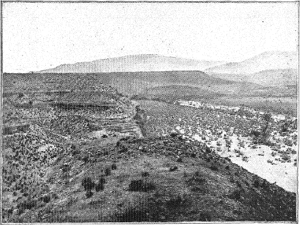
Plate XXVII. Ruin on Northern Point of Cavate Lodge Canyon.
There are remains of two villages connected with the cavate lodges just described, perched on the points of the promontories which form the mouths of the two canyons before mentioned. The location of these ruins is shown in plate XXV. The one on the southern promontory is of greater extent than that on the northern point, and both are now much broken down, no standing wall remaining. A general view of the ruin on the northern promontory is given in plate XXVII, and the same illustration shows the remains of the other village on the flat top of the promontory in the farther part of the foreground.
The cavate lodges are generally rudely circular in shape, sometimes oblong, but never rectangular. The largest are 25 and even 30 feet in diameter, and from this size range down to 5 or 6 feet and thence down to little cubby-holes or storage cists. Owing to their similarity,
There is great variety in the rooms, both in size and arrangement. As a rule each set or cluster of rooms consists of a large apartment, entered by a narrow passageway from the face of the bluff, and a number of smaller rooms connected with it by narrow doorways or short passages and having no outlet except through the large apartment. As a rule two or more of these smaller back rooms are attached to the main apartment, and sometimes the back rooms have still smaller rooms attached to them. In several cases there are three rooms in a series or row extending back into the rock, and in one instance (at the point marked E on the map, plate XXV) there are four such rooms, all of good size.
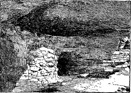
Fig. 290.—Walled storage cist.
Attached to the main apartment, and sometimes also to the back rooms, there are usually a number of storage cists, differing from the smaller rooms of the cluster only in size. These cists or cubby-holes range in size from a foot to 5 feet in diameter, and are nearly always on a level of the floor, although in some instances they extend below it.
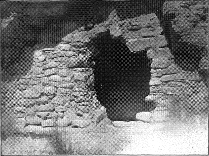
Plate XXVIII. Cavate Lodge with Walled Front.
As a rule the cavate lodges are set back slightly from the face of the bluff and connected with it by a narrow passageway. Another type, however, and one not uncommon, has no connecting passageway, but instead opens out to the air by a cove or nook in the bluff. This cove was used as the main room and the back rooms opened into it in the usual way by passageways. A number of lodges of this type can be seen in the eastern side of the northern promontory or bluff. Possibly lodges of this type were walled in front, although walled fronts are here exceptional, and some of them at least have been produced by the falling off of the rock above the doorway. The expedient of walling up the front of a shallow cavity, commonly practiced in the San Juan region, while comparatively rare in this vicinity, was known to the dwellers in these cavate lodges. At several points remains of front walls can be seen, and in two instances front walls remain in place. The masonry, however, is in all cases very rough, of the same type as that shown in plate XXVIII.
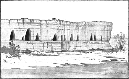
Plate XXIX. Open Front Cavate Lodges on the Rio San Juan. larger view
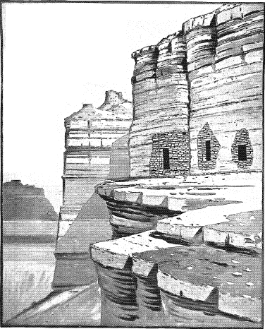
Plate XXX. Walled Front Cavate Lodges on the Rio San Juan.
In this connection a comparison with the cavate ledges found in other regions will be of interest. In 1875 Mr. W. H. Holmes, then connected with the Hayden survey, visited a number of cavate lodges on the Rio San Juan and some of its tributaries. Several groups are illustrated in his report.5 Two of his illustrations, showing, respectively, the open front and walled front lodges, are reproduced in plates XXIX and XXX. The open front lodges are thus described:
I observed, in approaching from above, that a ruined tower stood near the brink of the cliff, at a point where it curves outward toward the river, and in studying it with my glass detected a number of cave-like openings in the cliff face about halfway up. On examination, I found them to have been shaped by the hand of man, but so weathered out and changed by the slow process of atmospheric erosion that the evidences of art were almost obliterated.
The openings are arched irregularly above, and generally quite shallow, being governed very much in contour and depth by the quality of the rock. The work of excavation has not been an extremely great one, even with the imperfect implements that must have been used, as the shale is for the most part soft and friable.
A hard stratum served as a floor, and projecting in many places made a narrow platform by which the inhabitants were enabled to pass along from one house to another.
Small fragments of mortar still adhered to the firmer parts of the walls, from which it is inferred that they were at one time plastered. It is also extremely probable that they were walled up in front and furnished with doors and windows, yet no fragment of wall has been preserved. Indeed, so great has been the erosion that many of the caves have been almost obliterated, and are now not deep enough to give shelter to a bird or bat.
Walled fronts, the author states, were observed frequently on the Rio Mancos, where there are many well-preserved specimens. He
The walls were in many places quite well preserved and new looking, while all about, high and low, were others in all stages of decay. In one place in particular, a picturesque outstanding promontory has been full of dwellings, literally honeycombed by this earth-burrowing race, and as one from below views the ragged, window-pierced crags [see plate XXX] he is unconsciously led to wonder if they are not the ruins of some ancient castle, behind whose moldering walls are hidden the dread secrets of a long-forgotten people; but a nearer approach quickly dispels such fancies, for the windows prove to be only the doorways to shallow and irregular apartments, hardly sufficiently commodious for a race of pigmies. Neither the outer openings nor the apertures that communicate between the caves are large enough to allow a person of large stature to pass, and one is led to suspect that these nests were not the dwellings proper of these people, but occasional resorts for women and children, and that the somewhat extensive ruins in the valley below were their ordinary dwelling places.
It will be noticed that in both these cases there are associated ruins on the mesa top above, and in both instances these associated ruins are subordinate to the cavate lodges, in this respect resembling the lodges on the Verde already described. This condition, however, is not the usual one; in the great majority of cases the cavate lodges are subordinate to the associated ruins, standing to them in the relation of outlying agricultural shelters. Unless this fact is constantly borne in mind it is easy to exaggerate the importance of the cavate lodges as compared with the village ruins with which they are connected.
The cavate lodges near San Francisco mountain in Arizona were visited in 1883 by Col. James Stevenson, of the Bureau of Ethnology, and in 1885 by Maj. J. W. Powell. Major Powell6 describes a number of groups in the vicinity of Flagstaff. Of one group, situated on a cinder cone about 12 miles east of San Francisco peak, he says:
Here the cinders are soft and friable, and the cone is a prettily shaped dome. On the southern slope there are excavations into the indurated and coherent cinder mass, constituting chambers, often 10 or 12 feet in diameter and 6 to 10 feet in height. The chambers are of irregular shape, and occasionally a larger central chamber forms a kind of vestibule to several smaller ones gathered about it. The smaller chambers are sometimes at the same altitude as the central or principal one, and sometimes at a lower altitude. About one hundred and fifty of these chambers have been excavated. Most of them are now partly filled by the caving in of the walls and ceilings, but some of them are yet in a good state of preservation. In these chambers, and about them on the summit and sides of the cinder cone, many stone implements were found, especially metates. Some bone implements also were discovered. At the very summit of the little cone there is a plaza, inclosed by a rude wall made of volcanic cinders, the floor of which was carefully leveled. The plaza is about 45 by 75 feet in area. Here the people lived in underground houses—chambers hewn from the friable volcanic cinders. Before them, to the south, west, and north, stretched beautiful valleys, beyond which volcanic cones are seen rising amid pine forests. The people probably cultivated patches of ground in the low valleys.
About 18 miles still farther to the east of San Francisco mountain, another ruined village was discovered, built about the crater of a volcanic cone. This volcanic peak is of much greater magnitude. The crater opens to the eastward. On the
It will be seen that the first group described bears a remarkably close resemblance to the cavate lodges on the Rio Verde. The lodges themselves are smaller, but the arrangement of main apartment and attached back rooms is quite similar. It will be noticed also that in the second group described village ruins are again associated on the summit of the cliff or ridge. Major Powell ascertained that these cavate lodges were occupied by the Havasupai Indians now living in Cataract canyon, who are closely related to the Walapai, and who, it is said, were driven from this region by the Spaniards.
The cavate lodges on the Rio Grande, in New Mexico, in the vicinity of the modern pueblo of Santa Clara, were also visited in 1885 by Major Powell and are thus described by him:7
The cliffs themselves are built of volcanic sands and ashes, and many of the strata are exceedingly light and friable. The specific gravity of some of these rocks is so low that they will float on water. Into the faces of these cliffs, in the friable and easily worked rock, many chambers have been excavated; for mile after mile the cliffs are studded with them, so that altogether there are many thousands. Sometimes a chamber or series of chambers is entered from a terrace, but usually they were excavated many feet above any landing or terrace below, so that they could be reached only by ladders. In other places artificial terraces were built by constructing retaining walls and filling the interior next to the cliffs with loose rock and sand. Very often steps were cut into the face of a cliff and a rude stairway formed by which chambers could be reached. The chambers were very irregularly arranged and very irregular in size and structure. In many cases there is a central chamber, which seems to have been a general living room for the people, back of which two, three, or more chambers somewhat smaller are found. The chambers occupied by one family are sometimes connected with those occupied by another family, so that two or three or four sets of chambers have interior communication. Usually, however, the communication from one system of chambers to another was by the outside. Many of the chambers had evidently been occupied as dwellings. They still contained fireplaces and evidences of fire; there were little caverns or shelves in which various vessels were placed, and many evidences of the handicraft of the people were left in stone, bone, horn, and wood, and in the chambers and about the sides of the cliffs potsherds are abundant. On more careful survey it was found that many chambers had been used as stables for asses, goats, and sheep. Sometimes they had been filled a few inches, or even 2 or 3 feet, with the excrement