SUBSCRIBING LIBRARIES
Reading edition
Adelaide, S. AustraliaPublic Library of South Australia
Albany, N.Y.State Library
Ann Arbor, Mich.University of Michigan
Baltimore, Md.Enoch Pratt Free Library
"Johns Hopkins University
Boston, Mass.Athenæum Library
"Public Library
Brampton, Ont.Public Library
Brooklyn, N.Y.Public Library
Buffalo, N.Y.Buffalo Historical Society
Calgary, AlbertaWestern Canada College
Cambridge, Eng.University Library
Cambridge, Mass.Harvard University
Chicago, Ill.Newberry Library
"Public Library
"The John Crerar Library
"University of Chicago
Cincinnati, OhioPublic Library
Detroit, Mich.Public Library
Dublin, IrelandTrinity College
Edmonton, AlbertaAlberta Provincial Library
Fort William, Ont.The Women's Canadian Club
Glasgow, ScotlandMitchell Library
"University of Glasgow
Halifax, N.S.Presbyterian College
"Nova Scotia Legislative Library
Hamilton, Ont.Public Library
Hanover, N.H.Dartmouth College
Kingston, Ont.Queen's University
Lansing, Mich.Michigan State Library
Lawrence, Kan.University of Kansas
London, EnglandRoyal Colonial Institute
"Royal Geographical Society
"The Colonial Office Library
London, Ont.Public Library
Lynn, Mass.Public Library
Madison, Wis.State Historical Library of Wisconsin
Minneapolis, Minn.Minneapolis Athenæum
Montpelier, Vt.Vermont Historical Society
Montreal, P.Q.Fraser Institute
"Montreal College
"Normal School Library
New Haven, Conn.Yale University
Newcastle-upon-Tyne, England Public Library
New York, N.Y.Public Library
"New York Historical Society
Northampton, Mass.The Forbes Library
Ottawa, Ont.Dominion Archives
"Library of Parliament, Canada
Oxford, EnglandBodleian Library
Paris, FranceBibliothèque de l'Université de Paris
"Bibliothèque Nationale
Philadelphia, Pa.The Library Company of Philadelphia
Poughkeepsie, N.Y.Vassar College
Providence, R.I.Brown University
"The John Carter Brown Library
Quebec, P.Q.Legislative Library of Quebec
"Quebec Literary and Historical Society
Salem, Mass.The Essex Institute
Sacramento, Cal.State Library of California
St. John, N.B.Free Public Library
St. Louis, Mo.St. Louis Mercantile Library Association
St. Paul, Minn.Minnesota Historical Society
St. Thomas, Ont.Elgin Historical and Scientific Institute
Stratford, Ont.Public Library
Toronto, Ont.The Canadian Bank of Commerce
"Department of Education, Ontario
"Legislative Library, Ontario
"Osgoode Hall
"Provincial Archives
"Public Library
"University of Toronto
"Victoria University
Urbana, Ill.University of Illinois
Victoria, B.C.Legislative Library of British Columbia
Washington, D.C.{ Bureau of American Ethnology, Smithsonian
{ Institution
"Library of Congress
West Point, N.Y.United States Military Academy
Winnipeg, Man.Alpine Club of Canada
"Women's Canadian Club
Worcester, Mass.Free Public Library
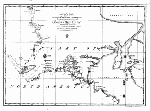
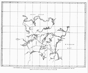
A Map exhibiting M^R. HEARNE'S TRACKS in his two Journies for the discovery of the Copper Mine River in the Years 1770, 1771 and 1772 under the direction of the Hudson's Bay Company
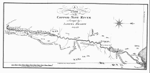
A Plan of the Copper-Mine River Surveyed by Samuel Hearne July 1771
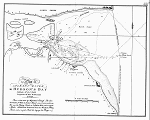
A Plan of ALBANY RIVER in Hudson's Bay Latitude 52°.12'.0" North Longitude 82°.40'.0" W. from London by S.H. 1774 Plan is laid down by Magnetical Compass. The three hummocks of Wood on Sawpit Island can be seen in clear weather over the Factory Island, in 3 fathom Water, and is a good Mark. Saddle-back hummock bears due West from Albany Roads and is a good Mark for laying the Buoys.
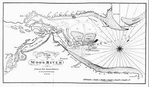
Plan of Moos River in Hudsons Bay, North America Lat. 53°N. Lon. 83°W. from London by S.H. 1774.
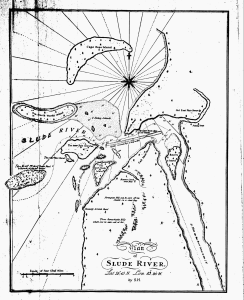
Plan of Slude River. Lat. 52°.15' N. Lon. 83°.20' W. by S.H.
A MAP EXHIBITING MR. HEARNE'S TRACKS IN HIS TWO JOURNEYS FOR THE DISCOVERY OF THE COPPERMINE RIVER IN THE YEARS 1770, 1771, AND 1772 Adjusted, as far as possible, in accordance with the latest maps by J. B. Tyrrell, 1909
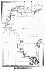
MAP OF COPPERMINE RIVER as surveyed by SIR JOHN FRANKLIN IN 1821 Scale—14½ miles in 1 inch References—t Observation for Latitude. O Observation for Longitude. Y Variation. T Dip. From Franklin's "Narrative of a Journey to the Shores of the Polar Sea"