Chapter III
Reading edition
Construction of the Geography of Mr. Park’s Expedition into Africa.
I next proceed to the detail of Mr. Park’s geographical materials. Should it be objected that I have been too diffuse and particular, in this part, I can only say, that since the information itself could not, from its nature be correct, it became the more necessary to investigate it closely, and also to place, not only the result but the detail of the investigation, together with the original documents themselves, in the form of notes, in the hands of the public, that the true grounds of the construction, might be known. For whether it may happen, that no further lights should ever be obtained, concerning the subject; or whether some other traveller, more fortunate (for he cannot possess more zeal, enterprize, temper, or firmness) should complete Mr. Park’s work; in either case, the original documents, as well as the mode of working them up, should be recorded; in the former, that we may know how to appreciate them; in the latter, how best to improve them. The successor of Mr. Park, cannot have too extensive a knowledge of the detail of his predecessor’s work; in order that he may know what parts require correction; and how to avoid delays, from a useless attention to objects, that are already attained.
Two new Maps have been constructed for the occasion. The one contains the Progress of Discovery and Improvement in various parts of North Africa; the other, the Geography of Mr. Park’s Expedition, as well as the result of his particular inquiries in the same quarter; on a more extended scale. The present remarks and discussions refer particularly to the latter.
In the construction of this map, it is first required to state those points, on which Mr. Park’s outset depends; as also those which affect the position of Fort St. Joseph, near to which he passed; as they differ from the maps in present use. And, as some positions in the journey of Mess. Watt and Winterbottom, serve very much to aid the improvement of the geography, it will be proper to speak of them also.
Cape Verd, and Fort St. Louis, at the mouth of the Senegal river, are placed according to the observations and results of M. Fleurieu.[55]
Jillifrey, on the Gambia river is, from the mean of the longitudes set forth by D’Anville, D’Apres, and Woodville, and which do not differ amongst themselves, more than 4½ minutes.[56]
The detail of the coasts, as well as the lower parts of the rivers between Cape Verd, and Cape Verga, are also from the charts of M. Woodville. That part between Cape Verd and latitude 18°, is adjusted to M. Fleurieu’s result of longitude, whilst the particulars are from D’Anville and Woodville.
The course of the Rio Grande from the sea to the break near the river Dunso, is from Dr. Wadstrom’s map. The Dunso river, crossed by Mr. Watt, appears evidently to be a continuation of the same river; several branches of which flow from the south-east. And the high tract of mountainous land beyond it, is no doubt a branch of the great ridge above commemorated, under the name of Komri, in the work of Abulfeda.
The route of Mr. Watt is described from a sketch communicated by the late Mr. Beaufoy,[57] in which the scale appears, on a reference to the original journal, to be intended for British miles. I have regarded them accordingly; whence Laby and Teembo are placed much nearer to the coast, than Dr. Wadstrom’s map represents: for it appears by the Journal, that Kissey, at the head of the river of the same name, is no more than eight journies from Teembo. Nor has the map more than 120 geographic miles between them, admitting the scale to be British miles, as I have concluded.[58]
The nearest point in Mr. Park’s route falls at 112 G. miles to the northward of the extreme point of Mr. Watt’s; and the river Gambia lay nearly midway between them. Thus, the map of Mr. Watt forms a most useful point of comparison; and adds confirmation to the report of the natives, respecting the course of the Gambia; for Mr. Park was told, that it was crossed in the way from the Falemé river, to Foota Jallo, of which Teembo is the capital.
Pisania, on the Gambia (called also Kuttijar Factory), the place of Mr. Park’s outset[59] is stated by D’Anville to be 170 G. miles above Jillifrey, by the difference of longitude; but by M. Woodville’s map, no more than 156; which answers better to the statement of the land journey; for Mr. Park was told that it was no more than 6½ journies of a messenger.[60]
Pisania then, is placed in longitude 13° 28′, according to this result; and in latitude 13° 35′ north, according to Mr. Park’s observation, by sextant.
The causes of the apparent wanderings of Mr. Park having been explained in the former part of this work, it will be no farther necessary to trace his course, than merely to explain the connection of the different parts of the data for the general construction.
Since the scale of the Map is fixed by the computed distances arising on the intervals of time employed in Mr. Park’s route, it is possible that some readers may be startled at the idea of following such an apparently vague authority. Those, however, who have been much in the habit of observing their rate of travelling, will be easily convinced that distances may be approximated; and those in particular who have been much accustomed to travel in countries, where time regulates the distance; or who have been in habits of working up geographical materials of this kind, will be the most easily convinced. It will of course be understood, that calculations of this kind can only be received from persons of judgment and experience: and also, that when opportunities of checking them, occur, they are always resorted to; after which, of course, no alternative remains, but to adopt the corrected distance.
In the present case, the rate of travelling of camels,[61] does not apply; as Mr. Park’s journey outwards was made on horseback, and his return chiefly on foot. Nor are camels, indeed, in use in that line of route. The checks to be employed, are the number of journies reported by the travelling merchants, from different points of Mr. Park’s route to Sego and Tombuctoo; and also those from the quarters of Morocco, Tunis, and Fezzan, to Tombuctoo; using as a scale, the rate arising on the route between Fezzan and Egypt, Morocco and Jarra, as the best known lines of distance. These, altogether, furnish such kind of authority as will, I trust, lead to a satisfactory conclusion; as the general coincidence is certainly very striking.
My mode of procedure has been, to calculate, in the first instance, Mr. Park’s bearings and distances, and then to correct the bearings by his observed latitudes, as far as these extend: and beyond that, I have taken his bearing by compass, and allowed the supposed quantity of variation.
The result of these calculations, together with the addition of his line of distance from Sego to Tombuctoo, was then compared with the popular report of the distance between the several stations of Woolli, Fort St. Joseph, Bambouk, and Tombuctoo. It was found that these reports did not materially differ from the aggregate distance given by Mr. Park; although they fell short of it; a difference which might naturally have been expected, and which I have ventured to alter. The difference, however, does not exceed twenty-four geographic miles; a mere trifle in African geography. The position of Tombuctoo, so obtained, differs only half a degree in latitude, and still less in longitude, from that arising from the intersection of the lines of distance from Morocco on the NW, and Fezzan on the NE: of which a particular account will be given in the sequel.
A great part of Mr. Park’s geographical memorandums are totally lost: but fortunately his bearings by compass during a great part of the way, are preserved. In other parts, he has preserved only the calculation of latitude and longitude, arising from them; which, however, of course furnish the means of obtaining the bearings, if necessary. As he omitted to take observations to determine the quantity of the variation of the compass, after he lost the means of correcting his course by observations of latitude, which was at Jarra, about midway in his route:[62] it becomes a question of some importance, what quantity to allow on those long lines of distance between Jarra and Silla; Silla and Manding.
It appears on inquiry, that the quantity of variation is no more known, any where within the continent of Africa, than within that of New Holland. And it happens moreover, that the lines of equal quantities of variation, do not run across Africa with that degree of regularity and parallelism, which takes place over great part of the Atlantic and Indian oceans (at least this is what appears clearly to my judgment): so that it became necessary to inquire, what quantity prevails in the surrounding seas; and what the general direction, as well as the particular nature, and tendency, of the curves, of the lines of equal quantities?
The variation lines on the globe have occupied a good deal of my attention at different periods of my life, and therefore the application of such new observations as the assiduity and kindness of my friends had procured for me on this occasion, was less difficult, than if the subject had been new to me. A dissertation on the subject, would be out of place here; and therefore I shall only give the result of my inquiries, in abstract; after premising, that the theoretical part belonging to the interior of Africa, is founded on a supposed continuation of those lines of equal quantities, whose tendency has been already ascertained, in the surrounding seas. I am perfectly aware, that some may regard the assumption as too great: but they will no doubt admit, at the same time, that it is difficult to conceive a more probable arrangement: and what is much more to the purpose, is, that if we are compelled to abandon the system, in the gross, the quantity of variation in the line of Mr. Park’s travels, cannot be greatly different from what we have assumed. For, whether the line of 18° in the south Atlantic, be a continuation of that in the north Atlantic, or of that in the Indian sea, much the same result will follow: only that in the former case, the quantity will be somewhat greater.
Chart of the Lines of Magnetic Variation, in the Seas around Africa. Published by James Rennell May 18th. 1798.
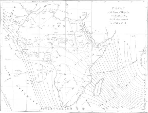
It would appear, that between the East Indies and South America, Europe and South Africa, there are four distinct sets of what may be termed concentric curves of variation lines, on the globe, and whose highest points of convexity are opposed to each other, within the great body of Northern Africa. The accompanying sketch will best explain it.[63] It would appear moreover, that from the place of opposition of these curves, in Africa, where the quantity of variation is 18°, it decreases with great rapidity, and finally to nothing, in going eastwards to India, or south-westward to south America: and that from the same point, it increases, in going NNW, towards Ireland, or to the opposite quarter, towards the coast of Caffraria. But the change is not in any proportion so rapid in the increase, in going north or south, as in the decrease, in going east or west. Such are the outlines of this system; by which, if a person was to set out from Cape Verd, or Cape Blanco, to traverse Africa from WSW to ENE, to Upper or Lower Egypt, he would find at setting out, from 15½ to 16½ degrees of westerly variation, which would increase to 18° about the centre of the continent, and afterwards decrease to a less quantity than at his setting out. Mr. Park’s travels being comprized between Cape Verd and the centre of Africa, will therefore be in the quarter that has from 16 to 18 degrees; and the part more particularly, where, from the want of observations of latitude, we must depend on his compass bearings, nearer 18° than 17°.[64] I shall now proceed to the detail of Mr. Park’s materials.
Leaving Pisania, Mr. Park proceeded eastward to Medina,[65] the capital of Woolli; and thence to the ENE, through the countries of Bondou, Kajaaga, and Kasson; the two latter of which are separated by the river of Senegal.
In his way, he took observations of latitude at Kolor, Koorkoorany, and Joag, on this side the river: by which means we are enabled to correct the parallels. The distance at present is left as it stands in the Journal, with a view of correcting it afterwards. The result of these bearings and distances (the particulars of which appear below),[66] places Joag at 247 miles east of Pisania; and the latitude, by two different observations, was found to be 14° 25′.[67]
At Joag Mr. Park was informed that Dramanet, which is about 2½ miles to the eastward of Fort St. Joseph, was 10 miles to the westward of him. That fort is said to be in 14° 34′, or 9 min. north of Joag; so that it ought to lie to the north-west, rather than to the west: and accordingly, there is found, in the map in Labat,[68] a place named Gacouva, no doubt meant for Joag, on the SE of St. Joseph; and in point of distance answering to it. Other places in the same map of Labat, are also recognized in the route of Mr. Park; so that the connection between it and the French settlement on the Senegal, is very clearly made out; which is a circumstance of some importance in this geography.
It will appear that the reckoning kept by Mr. Park gave 89 min. difference of latitude between Pisania and Joag, whilst the observation gave 50 only. About 9 minutes may be placed to the account of excess of distance, and 30 will then remain, on the whole distance of 253 geographic miles. In other words, the dead reckoning, corrected by allowing 17 degrees of westerly variation, gave a course of E 20°½ N; which, however, by the observations of latitude, is shewn to be E 11°¼ N (or E by N) making a difference of 9¼ degrees. But this I regard as coming very near, considering the circumstances under which the reckoning was kept.
From Joag we accompany Mr. Park to Kooniakarry and Jarra. The reckoning between the two first gives about 23¼ min. difference of latitude, 55 of easting.[69] And hence the latitude of Kooniakarry will be 14° 48′ by account; but the observation taken at Jumbo, in its neighbourhood, giving only 14° 34′, the account is 14 to the north; equal to about a point and quarter in bearing. The same mode of correction has been applied here, as in the former part of the route; that is, the whole distance has been (for the present) allowed; with the difference of latitude by observation; and hence Kooniakarry will fall 59½ geographic miles to the east of Joag.
The route from Kooniakarry to Jarra[70] may be divided into two parts; first, to Feesurah, a place of observation, south-eastward; and secondly, to Jarra, north-eastward.
The account to Feesurah agrees very nearly with the bearings and distance. The latitude by observation was 14° 5′, and the easting from Kooniakarry, corrected, 47 miles. Then, to Jarra, the account also agrees very nearly; the latitude was 15° 5′, that is, just one degree north of Feesurah; and the easting from thence 33 miles.
The aggregate of easting, between Joag and Jarra, is then 139½ miles.[71]
It may be observed, that throughout this journey, generally, the reckoning has been to the northward of the observations; and that, by about ten degrees on the whole traverse, when 17 degrees of variation have been allowed. It will hardly be supposed that the difference arises from allowing too much variation by ten degrees; but it is singular, that the error should, in all cases but one, lie the same way. I do not by any means regard the error as considerable, circumstances considered:[72] nor is it of any consequence in the parts where the observations of latitude serve to correct it: as between Pisania and Jarra.
Mr. Park was plundered of his sextant at Jarra, which accident of course put an end to his observations of latitude; and thus, unfortunately, left the remaining half (very nearly) of his geography in a state of uncertainty, as to parallel. This point, therefore, must be regarded as the most advanced geographical station, that rests on any certain basis of parallel. However, the remaining part of the route will not appear to be much out, when it is seen how nearly the bearing of Sego, as determined by Mr. Park, agreed with the line of direction pointed out from Jarra.
It is, no doubt, a favourable circumstance, that the instrument was not lost at an earlier period, and before the commencement of the intricate route between the pass of the Senegal river and Jarra; to which may be added, the advantage of a known parallel, from whence to set off the very important bearing of Tombuctoo. In effect, the bearing was pointed out from Benowm, but this place being nearly east from Jarra, and the bearing in question E ½ N, no error of any magnitude can be looked for.
Jarra (called also Yarra), has already appeared in the Maps drawn for the Association, and was originally taken from M. Delisle’s Map; but was neglected, or overlooked, by M. D’Anville. In the former Map it was placed somewhat more to the west, and in a higher parallel by about ¼ of a degree.
Between Jarra and Wassiboo, Mr. Park’s reckoning, as it appears wrought up in his table of day’s works, gives 41 min. diff. of latitude N, and 1° 31′ diff. longitude E; which reduced to departure, in miles, is 89, and produces a course of E 26° S. But he allowed no variation after he left Jarra: and as I allow 17°, the course must be taken at E 9° S, distance 96½ geographic miles. From this arises a diff. lat. of 16′ only; departure 95: and, hence, Wassiboo should be in latitude 14° 49′, and 95 east of Jarra.[73]
Mr. Park was so lucky as to preserve his original bearings,[74] between Wassiboo, and Diggani (a place about 15′ short of Sego); and these alone, out of all that were taken during the route. These give a course of E 27°½ S, 174 geographical miles; so that when 17° of variation are allowed, the true course will be E 10½ S; the diff. lat. 31,7; departure 171,1; whence Diggani should be in lat. 14° 17′, and 266,1 east of Jarra.
Between Diggani and Sego (returning again to the table of latitude and longitude), Mr. Park’s account gives E 43 S 15′; or corrected E 26 S, which gives diff. lat. 6,6; departure 13,5: so that Sego, the capital town of Bambara, falls, by this account, in lat. 14° 10′ 30″ and 279,6 east of Jarra.[75]
In this position, it bears E 10½ S from Jarra, distant 284 geographical miles. It is important to mention, that whilst at Jarra, the bearing of Sego was pointed out to Mr. Park by compass, ESE, or E 22°½ S. His route made it E 27°½ S, or 5° more to the south. This difference, so trifling in a distance of about 330 of our miles, on a straight line (in other words, the distance from London to Edinburgh), is not worth investigating. If we could suppose the report of the natives to be true, it would place Sego nearly 25 minutes more to the north. For my own part, I do not believe that any person, from mere judgment, unassisted by geographical records, and so far removed as to be out of the hearing of cannon, and of the view of conflagrations (two circumstances that aid the most in fixing the line of direction between distant places), could ever come nearer than several degrees of the bearing of two places that are 330 British miles asunder.[76]
Having at length reached the banks of the long sought for river Niger (or Joliba), near which the city of Tombuctoo stands, Mr. Park proceeded along it several days’ journey, towards the city in question, on a course E 15½ N by compass, but corrected E 32½ N 70 G. miles; which giving a diff. lat. of 37½, departure 59, places Silla, the extreme point of his expedition, in latitude 14° 48′; and longitude by reckoning 0° 59′ west of Greenwich; but, as will be hereafter shewn, when corrected, 1° 24′ west. Here, then, terminates his journey eastward, at a point somewhat more than 16 degrees east of Cape Verd, and precisely in the same parallel. The line of distance arising from this difference of longitude is about 941 G. miles, or 1090 British, within the western extremity of Africa; a point which, although short by 200 miles of the desired station, Tombuctoo, the attainment of which would unquestionably have been attended with great eclat, was yet far beyond what any other European, whose travels have been communicated to the European world, had ever reached.[77]