LETTER OF TRANSMITTAL (continued 4)
Reading edition
Survey—Forest Grove to Gaston
A survey was made from Forest Grove to Gaston, a distance of approximately 6 miles. The alignment follows the existing road with the exception of a change at Dilley to eliminate two railroad crossings.
Considerable grading was done between Dilley and Gaston, reducing the grade to five per cent.
Mr. C. G. Reiter, County Surveyor of Washington County, was employed as locating engineer for the State, and also supervised the grading in both of the above sections.
WHEELER COUNTY
Wheeler County, being without either rail or water transportation facilities, is entirely dependent upon its roads for communication with outside points, as well as between points within the County. All of the large amount of agricultural products of the county must be transported for long distances over roads and highways, and likewise, all manufactured articles and other supplies from points without the County must be brought in over them. For that reason, good roads are of the utmost importance to all of Wheeler County, which fact is fully recognized by the Wheeler County people.
Every effort is being made by the County to build up and improve its road system, but the funds available within the County are entirely inadequate. In November, 1916, bonds were voted to the amount of $80,000.00, the maximum allowed the County under the State laws, but this amount is hardly enough to make a beginning on the necessary road construction in the county, as Wheeler County is rough and mountainous, and road construction is therefore heavy and expensive.
The State Highway Commission realizing the importance of the construction of roads in this County, and the impossibility of the financing of their construction by the County alone, early determined to assist to the greatest possible extent.
Surveys have been made by the Department over all but two miles of the two most important cross-county roads, the John Day River Highway and the McKenzie River Highway. During 1917 and 1918 the State Highway Department expended the sum of $46,997.79, cooperating with the County in the construction of 4.2 miles of grading and macadamizing between Fossil and the Gilliam County Line. State aid was also granted the County to the amount of $14,235.45 for the construction of nine-tenths of a mile, known as the Bridge Creek Section, on the McKenzie River Highway just west of Mitchell, the total cost of which was $24,235.45.
For the construction of 25.5 miles on the John Day River Highway between the mouth of Sarvice Creek and the Grant County Line, the Highway Department has set aside the sum of $63,345.70 to be added to 63,345.70 of Federal Post Road Funds and $36,000.00 of county funds to provide the total amount of $162,691.40 which the project is estimated to cost.
The Department has further been instrumental in securing Federal Aid for the construction of a Forest Road Project 5.5 miles in length between Mitchell and the Crook County Line, known as the Ochoco Canyon Project. On this project the State will expend $20,050.00, the Federal Government, $20,050.00 and the County, $4,900.00, $45,000.00 in all.
In summary, State Aid and Federal Government Aid extended to Wheeler County during 1917 and 1918 and set aside to be expended in 1919 and 1920, are as follows:
State Funds County Funds Federal Govt. Funds Total
Expended in 1917 and 1918—
On grading Cummings Hill Sec. $ 7,004.85 $ 7,527.50 ... $ 14,532.35
On macadamizing Cummings Hill Section 32,465.44 ... ... 32,465.44
On grading Bridge Creek Sec. 14,235.45 10,000.00 ... 24,235.45
Total $ 53,705.74 $ 17,527.50 ... $ 71,233.24
Appropriated for Expenditure in 1919 and 1920—
On Sarvis Creek-Grant County Line Section $ 63,345.70 $ 36,000.00 $ 63,345.70 $ 162,691.40
On Ochoco Canyon Section 20,050.00 4,900.00 20,050.00 45,000.00
Total $ 83,395.70 $ 40,900.00 $ 83,395.70 $ 207,691.40
Cummings Hill Grading
On June 19th 1917, a contract was let to the Elliott Contracting Co. of Portland, Oregon, for the construction of 3.5 miles of grade between the foot of Cummings Hill, north of Fossil, and the Gilliam County line. This construction was a five per cent development to eliminate the heavy grades and narrow roadbed of the former road. Work was commenced on July 6th, 1917, and completed on October 5th, 1917. The work of the contracting firm was very satisfactory, and an excellent piece of grading was secured. The Engineer in charge for the Highway Department was Mr. B. H. McNamee.
The total cost of the work was $14,532.35, of which the State paid $7,004.85 and Wheeler County $7,527.50. The detailed cost statement follows:
DETAILED EXPENDITURE STATEMENT—GRADING CUMMINGS HILL, SECTION
Engineering $ 1,423.30
Construction:
Common Excavation, 11,397 cu. yds. @ .40 $ 4,558.80
Intermediate Excavation, 6,017.4 cu. yds. @ .70 4,212.18
Solid Rock Excavation, 2,816.5 cu. yds. @ 1.35 3,802.27
12-inch Corr. Iron Pipe, 682 Lin. ft. @ .40 272.80
24-inch Corr. Iron Pipe, 40 Lin. ft. @ 1.00 40.00
Rubble Masonry, 22.3 cu. yds @ 10.00 223.00
13,109.05
$ 14,532.35
Bridge Creek Grading
The grading of a nine-tenth mile section in Bridge Creek Canyon was contracted to the United Contracting Co. of Portland, Oregon, on November 27th, 1917. This section is on the McKenzie River Highway about four miles west of Mitchell. In addition to the grading, the contract involved the construction of a ninety foot bridge over Bridge Creek.
The work was started on February 15th, 1918 and completed on June 20th, 1918. The engineering was in charge of Mr. R. H. Coppock.
The total cost of the work was $24,235.45 of which the State paid $14,235.45 and Wheeler County $10,000. The detailed cost statement follows:
DETAILED EXPENDITURE STATEMENT— GRADING BRIDGE CREEK SECTION
Engineering $ 635.30
Construction:
Common Excavation, 3935.6 cu. yds. @ .60 $ 2,361.42
Intermediate Excavation, 549.4 cu. yds. @ .75 412.05
Solid Rock Excavation, 9837.6 cu. yds. @ 1.40 13,772.64
Overhaul per 100 lin. ft., 363 cu. yds. @ .03 10.89
12-inch Corr. Iron Pipe, 20 lin. ft. @ .73 14.60
15-inch Corr. Iron Pipe, 108 lin. ft. @ .83 89.64
21-inch Corr. Iron Pipe, 60 lin. ft. @ 1.00 60.00
Rubble Masonry, 1.58 cu. yd. @ 12.50 19.75
Guard fence, 100 lin. ft. @ .85 85.00
1 90-foot Bridge & approaches:
Superstructure and trestle (Lump sum) $ 5,100.00
Class “A” Concrete in piers, 49.24 cu. yds. @ $34.00 1,674.16
$ 6,774.16
$ 23,600.15
$ 24,235.45
Macadamizing on Cummins Hill Section
On August 7th, 1917, no satisfactory unit price bid having been received, the State Highway Department entered into a “cost plus” contract with the Warren Construction Company of Portland, Oregon, to macadamize with broken stone the Cummins Hill Section between Fossil and the Gilliam County line, on the John Day River Highway. The rock for this work was crushed on the job, and the macadam surface was constructed sixteen feet wide with a compacted thickness of six inches.
Payment to contractor was made on the basis of actual cost plus a percentage of 10 per cent on labor and five per cent on materials.
To November 30th, 1918, the State had expended $32,465.44 on this work, and it is estimated that there are bills outstanding against it to the amount of $1,500.00.
In addition to the 3.4 miles of grading done by the State on Cummins Hill the County continued the grading at the foot of the hill for a distance of 0.7 miles, making a total of 4.2 miles. The full section has been macadamized, giving Wheeler County 4.2 miles of standard macadam road.
Butte Creek Summit Grading
During the 1918 season, the County has graded under State supervision, a one and seven tenths mile section about nine miles southeast of Fossil on the John Day River Highway. This section is known as the Butte Creek Summit Section. The construction was paid for entirely by the County. Engineering supervision was furnished by the State Highway Department, the engineer in charge of the work being Mr. B. H. McNamee.
The total amount expended by the County, prior to November 30th, on this work was approximately $30,000.00, and the quantities of construction completed to this date were as follows:
Common Excavation 8,000 cu. yds
Rock Excavation 12,000 cu. yds.
Pipe, 12-inch 234 lin. ft.
Pipe, 20-inch 72 lin. ft.
Pipe, 16-inch 100 lin. ft.
Clearing 8 acres
Grading between Cummins Hill and Fossil
During April and May, 1918, Wheeler County graded, under the direction of the State Highway Department, a section of the John Day Highway between Cummins Hill and Fossil. This grade was .7 of a mile in length and joined up with the Cummins Hill grading. This improvement cost the County approximately $4,000.00. Geo. Hibbert was inspector and transitman in charge for the State Department.
Survey of the John Day River Highway
With the exception of a two mile section immediately West of Fossil, the entire John Day River Highway through Wheeler County is covered by location survey made during the past two years. The total length of survey on this highway is 41.5 miles. For all but about twelve miles, of this total, the detailed plans are practically complete. The survey of this highway has been in charge of B. H. McNamee.
Survey of the McKenzie River Highway
The State Highway Department has completed a survey of the McKenzie River Highway in Wheeler County from the boundary of the Ochoco National Forest west of Mitchell to the Grant County Line near Dayville, a total distance of 48 miles. This survey was made by Locating Engineer R. H. Coppock. The plans are complete except for the eight miles west from the Grant County line.
From the west end of this survey at Ochoco Forest boundary, the Federal Office of Public Roads has made a survey to the Crook County line, so the survey of the McKenzie River Highway is complete all of the way through Wheeler County.
Survey of Highway No. 14
In 1917, pursuant to a request from the County Court, a section of Highway No. 14 between Mitchell and Antelope was surveyed. This survey begins at the point on the Mitchell-Prineville survey about four miles west of Mitchell and extends 1.4 miles down Bridge Creek to where connection is made with the present road. This survey was made by R. H. Coppock, locating engineer.
Sarvice Creek-Valades Ranch Post Road Project
Application has been made to, and approved, by the Federal Office of Public Roads for Post Road co-operation on a 48.5 miles section of the John Day River Highway in Wheeler and Grant Counties. 25.5 miles of this project are in Wheeler County and 23 miles in Grant County. The total estimated cost of the project is $400,433.79, and the funds are to be provided as follows: State $157,216.90, Government $157,216.89; Wheeler County $36,000.00 and Grant County $50,000.00.
The survey for this project parallels the John Day River on the north bank, through Wheeler County and extends from the mouth of Sarvice Creek in Wheeler County to Valades Ranch about four miles West of Dayville in Grant County. In Grant County a crossing is made to the west bank near the upper end of the Big Basin.
It is expected that construction will be commenced on the Sarvice Creek-Valades Ranch Project early in 1919.
Ochoco Canyon Forest Project
A Federal Aid Co-operative Agreement has been entered into between the State, the Federal Government, and Wheeler County for the grading of a 5.5 mile section on the McKenzie River Highway. This section is known as the Ochoco Canyon Section and extends from the Crook County line to a point about 16 miles west of Mitchell.
This work is estimated to cost $45,000.00 of which the State will pay $20,050.00, Wheeler County $4,900.00, and the Federal Government $20,050.00. It is expected that this section will be built during the 1919 season.
YAMHILL COUNTY
In Yamhill County the State Highway Department has co-operated with the County in the grading and paving of 3.2 miles between Rex and Newberg and of 4 miles between Sheridan and McMinnville. The total expenditure on this work amounts to $147,000.00 of which the County has paid $18,273.49.
An effort has been made to secure Federal Aid in the construction of a section of the Portland-Tillamook Highway from Grande Ronde west. With this in view, the necessary surveys have been made, and it is expected that Federal Aid will be secured so that the construction may be undertaken during the 1919 season.
Sheridan Paving—1917
In 1917 the Highway Department constructed with its own forces and equipment 1.8 miles of concrete pavement from Sheridan east on the Sheridan-McMinnville Road. This pavement was 16 feet wide, 61⁄2 inches thick at the center and 51⁄2 inches thick at the edges. The mix used was a 1 : 11⁄2 : 3.
In connection with the paving there was a considerable amount of grading, the total expenditure for grading, culverts, etc., being $5,651.70. The cost of the 1.8 miles of paving was $31,432.99, the unit cost being $1.82 per cubic yard.
Yamhill County co-operated in the payment for this work to the amount of $10,000.00. A complete statement of the costs on this work is given below.
COST STATEMENT—SHERIDAN PAVING—1917
Quantity Item Cost Unit Cost
2498 cu. yds. Common Excavation }
652 cu. yds. Intermediate Excavation $ 4,442.85 $ .906
1750 cu. yds. Solid Rock Excavation
182 lin. ft. 12-inch Culvert Pipe 283.90 1.56
118 lin. ft. 18-inch Culvert Pipe 276.00 2.34
44 lin. ft. 24-inch Culvert Pipe 134.20 3.05
290 lin. ft. 6-inch Porous Drain Tile 52.25 .18
25 cu. yds. Class “C” Concrete 462.50 18.50
17,150 sq. yds. Concrete Pavement 31,198.87 1.82
5050 lin. ft. Expansion Joints 234.12 .046
Total Construction Cost $ 37,084.69
Engineering 1,131.35
Grand Total Cost $ 38,216.04
Paid by State $ 28,216.04
Paid by County 10,000.00
Total $ 38,216.04
Sheridan Paving—1918
Early in 1918, Yamhill County requested that the concrete pavement laid in 1917 be continued to a total length of four miles, and offered to pay for all grading necessary in connection therewith. This request was granted by the Highway Commission and in the early spring, construction was started on the additional 2.2 miles.
The type of pavement laid on this section was the same as that laid in 1917, except that crushed rock aggregate was used instead of gravel, and the mix was reduced to 1 : 2 : 31⁄2.
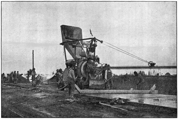
STATE OWNED PAVING PLANT IN OPERATION NEAR SHERIDAN IN YAMHILL COUNTY. ON THE YAMHILL NESTUCCA HIGHWAY
The coarse aggregate consisted of crushed stone ranging from 1⁄4 inch to 21⁄2 inches. For the fine aggregate, both Columbia River and Willamette River sand was used. The stone was crushed from a quarry operated by the State on Deer Creek which was near the center of the job and consisted of an altered basalt of rather coarse texture. The quality of this stone is not equal to the true basalt; but tests made by the Oregon Agricultural College showed that it was of good quality. The average haul on this material was .6 of a mile.
Crushing was begun early in March and 1200 cubic yards of material stored in a stock pile which was rehandled later by means of an automatic loader purchased by the State Highway Department for this class of work. The output of the crusher was insufficient to keep the mixer running and by means of this stock pile it was possible to keep the material coming on to the road steadily and finish the job in a minimum length of time and with the least inconvenience to traffic.
In this connection the experience on this job shows the advisability of using a stock pile of material to draw from in case of emergencies. When this is done the work is allowed to go ahead steadily, although a breakdown at the crusher may occur. The saving made by a steady run more than offsets the cost of rehandling the material, which is done very reasonably by the use of machinery.
The sand was shipped to Ballston and Sheridan by railroad, approximately equal amounts being shipped to both places and was so divided as to get a minimum length of haul on this material. The average haul was 3.5 miles. At Ballston the sand was unloaded from the cars into bunkers, which dumped directly into trucks, while at Sheridan no bunkers were available and the material was unloaded on the ground and rehandled by means of an automatic loader. No delay was caused by car shortage as we used our stock pile at Sheridan in emergencies. All the material was hauled and handled by means of trucks, two of which belonged to the State Highway Department, others working on a yardage basis.
The pavement, after being struck off, was finished by the roller and belt method; being rolled from two to four times, according to the condition of the concrete and later belted with eight and ten inch belts. The eight inch belt being used first. By using this method of finishing, we were able to eliminate the use of skilled labor, which showed a material saving in the finishing item, and at the same time secured a very satisfactory surface.
As soon as sufficiently hardened, the pavement was covered with earth from the roadside and kept moist for at least one week while curing. The earth covering was later removed by means of an ordinary road grader, when ready to be opened for traffic, the elastite joints being trimmed at the same operation.
A short stretch of pavement was left out at Deer Creek to allow a fill to settle during the winter rains. In conformity with our general practice, sufficient crushed rock was left on the job to complete this stretch and make repairs.
Elastite joints were placed every thirty feet and extended the entire width and depth of the pavement. Continuous forms were used on a portion of this pavement and were found to be much superior to the ordinary type, and the Department has adopted the continuous form for future work. These forms are made by using two pieces of form lumber 11⁄2 inches by 51⁄2 inches nailed together. The joints are lapped one-half the length of the stick. The finished form is 3x51⁄2 inches and is easily placed on either tangents or sharp curves.
The concrete was mixed with a sixteen cubic foot Koehring Mixer equipped with bucket and boom. The plant is owned by the Department.
The grading was paid for by Yamhill County and the crusher, roller, grader, and scarifier were also furnished by them free of charge. Earth shoulders were built along the pavement by means of road grader.
Mr. J. M. Baker was Superintendent of Construction on this work.
COST STATEMENT—2.2 MILES, 16-FOOT CONCRETE PAVEMENT, EAST OF SHERIDAN—BUILT IN 1918
Quantity and Item Total Cost Unit Cost
Grading $ 1,853.07
19,566 sq. yds., 1 : 2 : 31⁄2 concrete pavement Average thickness 6 inches 36,378.01 $ 1.86
6,192 lin. ft., Expansion Joints 247.68 .04
140 cu. yds., Broken Stone Macadam 420.00 3.00
Total Cost of Construction $ 38,898.76
Engineering 1,166.85
Grand Total Cost $ 40,065.61
5099 bbls. Cement used on this work at a cost of $13,299.00 F. O. B. Work.
15 yds. of Sand and 120 yds. broken stone left stored on job.
Paving—Multnomah County Line to Newberg
A complete description of the paving of the 15.7 mile section of the West Side Highway between the Multnomah County Line and Newberg is given in the Chapter devoted to Washington County. It should be mentioned here, however, that 3.2 miles of this pavement is within Yamhill County, and was built by the State at a cost of $57,500.00. The construction of the subgrade was paid for by Yamhill County, part of it having been done by County forces and the balance of it by the paving contractor under a cost plus 10 per cent agreement with the County. For the work done under this agreement, the contractor was paid $6,153.05.
Survey—Grande Ronde Section
A survey was made in the spring of 1918 between Grande Ronde and the Bee Ranch at the east end of the Sour Grass road improved in 1916. This is an important link about 61⁄2 miles in length on the Yamhill-Nestucca Highway, connecting as it does the cities of McMinnville, Willamina, Sheridan and Tillamook. In addition it will afford a short and direct route between the hay and grain fields of the Willamette Valley and the dairy ranches of the coast. Further, this highway is used by hundreds of autoists in summer enroute to the Tillamook beaches.
From the fact that only 21⁄2 miles of this section are in service as a postal route, Federal Aid could be applied for only on that section and cooperation has been requested as follows: United States Government $15,000; State of Oregon $15,000; Yamhill County $10,000. For the remaining four miles, Yamhill County has appropriated $5,000 from the 1919 funds.
It is estimated that the total cost of the remaining section will be $50,000 and it is expected that the work will be done in 1919. The entire project as proposed will be graded 24 feet wide, conforming to the State standards as to alignment and grade and surfaced with macadam 12 feet in width, thus closing the gap and affording a road between Portland and Tillamook which will be open the entire year.
Transcriber’s notes:
Several obvious typographical and lay-out errors have been corrected.
Inconsistencies in the original have been left as they were: geographical names in the tables are often spelled differently from those in the text, table lay-out is often inconsistent, several words are used spaced, hyphenated and/or non-hyphenated, both per cent. and per cent are used, etc.
In the Table of Contents, pages that have no page number in the original have been listed as —.
Page 154, under table COST STATEMENT: 15 yds. of sand should probably be 15 cu. yds. of sand; ditto for rock.
Table B, page 56: the (¶) symbol is not explained in the original document.
Table G: lowest price mentioned for riprap is $ 2.35 (last row), lowest price in column riprap is $ 2.75.