PART III.
Reading edition
GEOLOGY.
Section IX.—GENERAL AND CLASSIFICATION OF STRATA.
The geology of the area[33] under consideration is almost entirely stratigraphical, the only igneous rocks being more or less local lava flows. The sedimentary rocks of the district have yielded an abundant fauna, both invertebrate and vertebrate; the latter is of unique interest, including as it does a number of highly interesting animal types quite new to science. An extended examination in the field, and comparisons with the stratigraphical succession in other parts of Egypt, checked by the determinations of the fossil molluscan fauna, make it possible to form a very fair estimate of the approximate age of the different rock-stages, although this may necessarily be subject to modification when the specific determinations of the entire collection of organic remains have been completed, and the development of vertebrate life has been correlated and compared with that in other parts of the world.
The depression is cut out in a great series of sedimentary rocks of Middle Eocene, Upper Eocene, and Oligocene age, and one of the features of the stratigraphy of the region is the constancy of many beds over wide areas. The dip of the beds throughout the area is nearly due north and at a very low angle, averaging 2° or 3°, but varying from 1° to 5°; this low dip is very constantly maintained except when locally affected by small faults. The structural geology and tectonics have already been discussed at some length in the previous sections.
The oldest beds found in the depression are the clays, marls, and limestones with Nummulites gizehensis, of Middle Eocene age. These are succeeded by a group of white marly limestones and gypseous clays, which largely underlie the cultivated alluvium of the Fayûm. They are followed by a series consisting of clays, sandstones, and calcareous grits, some beds of which are characterized by the abundance of small nummulites and Operculina. The latter series is followed by the uppermost truly marine Eocene beds, a group of alternating clays, sandstones and limestones, the “Qasr el Sagha Series” (or Carolia beds), characterized by an abundant invertebrate and vertebrate fauna, and equivalent to the Upper Mokattam beds of Cairo.
Above the Qasr el Sagha series, and well marked off from them both lithologically and palæontologically, is found a great thickness of variegated sands, sandstones, clays and marls, the “Fluvio-marine Series” (Jebel el Qatrani beds), divided near the summit by one or more thick intercalated lava sheets, the latter forming a convenient junction line. This series of variegated beds is of Upper Eocene—Lower Oligocene age.
No Miocene strata have been recognized within the area, but further north, as at Mogara, Lower Miocene deposits occur;[34] and it is probable that there is a continuous series of lithologically similar beds from the summit of the Fayûm escarpments (Lower Oligocene) to the Mogara Miocene.
The Pliocene is probably represented by the great terraces of gravel—raised beaches—which are such a marked feature in the geology of the district. Fossiliferous Pliocene deposits have also been recorded from the south part of the area by Schweinfurth.[35]
Pleistocene and Recent are abundantly represented by lacustrine clays, both ancient and modern, alluvial land and blown sand, the formation of which deposits is continuing at the present time.
The following table will show the sequence of strata and the classification adopted in the present memoir:—
Table showing Succession and Classification of Strata in the Fayum.
Approximate average thickness in metres, north part of Fayum.
RECENT AND PLEISTOCENE Alluvial soil, clays, sands, etc.
Blown sand.
Lacustrine clays, extending to about 23 metres above sea-level.
(MIDDLE?) PLIOCENE Gravel Terraces (? Pleistocene).
Shell-borings on rock surfaces.
50 Fossiliferous deposits of Sidmant.
LOWER OLIGOCENE Tongrian Fluvio-marine Series (Jebel el Qatrani beds).
30 Sandstones and sandstone-grits with silicified trees and
Basalt sheets, interbedded and contemporaneous.
UPPER EOCENE Bartonian. 250 Variegated sands, sandstones, clays and marls, with limestone-grits and thin bands of limestone. The upper beds contain Unio sp., Lanistes bartonianus, Blanck., Turritella pharaonica, Cossm., Potamides scalaroides, Desh., P. tristriatus, Lam., Pleurotoma ingens, May.-Eym. In the lower beds are large numbers of silicified trees associated with vertebrate remains including Arsinoitherium Zitteli, Beadn., A. Andrewsii, Lankester, Palæomastodon Beadnelli, Andr., P. minor, Andr., Mœritherium Lyonsi, Andr., M. trigodon, Andr., Megalohyrax eocænus, Andr., M. minor Andr., Saghatherium antiquum, Andr. and Beadn., S. minus, Andr. and Beadn., S. magnum, Andr., Ancodus Gorringei, Andr. and Beadn., Geniohyus mirus, Andr., G. fayumensis, Andr., G. major, Andr., Phiomia serridens, Andr. and Beadn., Pterodon africanus, Andr., P. macrognathus, Andr., Eremopezus libycus, Andr., Testudo Ammon, Andr., and frequent crocodilian and chelonian remains.
MIDDLE EOCENE Parisian. Upper Mokattam 155 Qasr el Sagha Series (Carolia beds).
Alternating limestones, marls, clays and sandstones with Qerunia (Hydractinia) cornuta, May.-Eym., Astrohelia similis, Felix., Echinolampas Crameri, Loriol., Ostrea Reili, Fraas, Ostrea elegans, Desh., Alectryonia Clot-Beyi, Bellardi, Exogyra Fraasi, May.-Eym., Carolia placunoides, Cantr., Cardita fajumensis, Oppenh., Macrosolen Hollowaysi, Sowerby, Turritella pharaonica, Cossm., T. carinifera, Desh., Mesalia fasciata, Lam., Rimella rimosa, Sol. The vertebrate remains include Mœritherium Lyonsi, Andr., M. gracilis, Andr., Barytherium grave, Andr., Eosiren libyca, Andr., Zeuglodon Osiris, Dames, Gigantophis Garstini, Andr., Pterosphenus Schweinfurthi, Andr., Psephophorus eocænus, Andr., Thallassochelys libyca, Andr., Podocnemis antiqua, Andr., P. Stromeri, v. Rein., Stereogenys Cromeri, Andr., S. podocnemioides, v. Rein., Tomistoma africanum, Andr., with siluroids and Propristis Schweinfurthi, Dames.
Lower Mokattam 50 Birket el Qurûn Series (Operculina-Nummulite beds).
Sandstones and clays, with sandy limestones, and one or more well marked concretionary sandstones weathering into large globular masses.
Nummulites Fraasi, de la Harpe, N. Beaumonti, Operculina discoidea, Schwag., Qerunia cornuta, May.-Eym., Plicatula polymorpha, Bell., Pectunculus pseudopulvinatus, Orb., Cardita Viquesneli, d’Arch., Cardium Schweinfurthi, May.-Eym., Venus plicatella, May.-Eym., Macrosolen Hollowaysi, Sow., Lucina pharaonis, Bell., Tellina scalaroides, Lam., Clavellithes longævus, Sol., Voluta arabica, May.-Eym., Turritella pharaonica, Cossm., T. carinifera, Desh., with Zeuglodon Osiris, Dames, and Z. Isis, Beadn.
Ravine Beds.
70 White marls and marly limestones with gypseous clays; Nucularia sp. Leda sp., Corbula aff. pixidicula, Desh., Lucina sp. (? pharaonis), Tellina tenuistriata, Desh., Zeuglodon Isis, Beadn., and scales and teeth of fish.
Wadi Rayan Series (Nummulites gizehensis beds).
130 Limestones, marls, clays, etc., with Nummulites gizehensis, Ehrbg., N. curvispira, Carolia placunoides, Cantr.
Section X.—MIDDLE EOCENE (PARISIAN).
A.—Wadi Rayan Series.—(Nummulites Gizehensis Beds).
(A.I.e. Schweinfurth, I.b. Mayer-Eymar,[36] Lower Mokattam of Cairo).
Beds of this group are chiefly found in the south of the depression. The wadis Rayan and Muêla, as already shown by Schweinfurth and Mayer-Eymar[37], are cut out in clays and limestones of Lower Mokattam age; the upper beds of limestone, containing among other fossil[38] numerous examples of the large Nummulites gizehensis, form the greater part of the floor of the depression west of the Fayûm cultivation, stretching from Jebel Rayan to the foot of Gar el Gehannem,[39] 28 kilometres west of the western end of the Birket el Qurûn (Section XX). Near the latter hill examples of N. gizehensis of inordinately large size occur.[40]
At the conical hill at the southern entrance to Wadi Muêla the following beds were noticed:—
Top of hill.
1. Hard white limestone with small nummulites, Lucina, Callianassa, and echinids. Salt occurs in thin deposits along joint-planes. The lower part of this bed is largely composed of small nummulites and bryozoa. This generally white limestone passes down into
2. Brown, usually sandy, limestone with oysters and small nummulites. In it are intercalated thin beds of greenish brown sandstone and clayey sand with impressions of bryozoa. Some of the brown sandy limestones are full of small nummulites. Ostrea and Carolia numerous. The beds are not constant, the clayey sandstones passing insensibly into sandy limestones.
3. Softer beds with large nummulites, corals, Ostrea, Nautilus.
4. Soft green and brown clays, with occasional oyster-beds.
At the corner of the cliff 7½ kilometres N.N.W. of the monastery of Der el Galamûn, in Wadi Muêla, occur about 80 metres of hard white nummulitic limestones, with beds of argillaceous sandstone and sandy clays. Fossils are numerous and include nummulites of several species (N. gizehensis, etc.), Carolia placunoides, different species of Ostrea, with gastropods (among others Terebellum sopitum), bryozoa, etc. It is very noticeable that the nummulites, especially the small species, occur in remarkable profusion not only in the limestones but often in the clays.
The following section will give a good idea of the general alternations found in this area; it was measured at Jebel Rayan,[41] 24 kilometres west of the western end of the cultivation of Gharaq basin.
Top of plateau. Metres.
1. Hard snow-white limestone with occasional nummulites passing down into hard highly nummulitic limestone; N. gizehensis, Ostrea sp., Lucina sp., Mitra sp., and Carolia placunoides occur among others 31
2. Vertical-faced bed of greenish clayey sands and sandy clays (glauconitic) with Carolia, Ostrea and Nummulites. Near top of bed there is much gypsum. The nummulites in this bed are often collected together so as to form hard concretionary masses; these masses, by becoming more numerous, finally form a hard bed of nummulitic limestone intercalated in the clays near the top. The junction of the clays with the limestone of Bed No. 1 is very irregular 16
3. Greenish shelly sands and sandy clayey bands, interbedded with impure chalky nummulitic limestones with N. gizehensis, N. curvispira, and a third smaller species; Ostrea sp. This bed is much obscured by debris 11
4. Hard slate-blue shales, weathering to paper-shales 2
5. Brownish marls passing up into clays 2
Limestone band largely made up of small and large nummulites and echinids 1
Glauconitic (?) and clayey sands and sandy clays, with Ostrea, Carolia, and nummulites, weathering with a vertical face. In some bands large numbers of small and large nummulites lie embedded in every position, as if tossed about by currents during the process of becoming buried by sediment. Gypsum occurs in thin veins and often encloses the nummulites 36
6. Hard markedly-white nummulitic limestone full of N. gizehensis and other species (N. curvispira, etc.); the rock usually has a dark brown colour when freshly fractured. A shelly band rich in corals occurs nine metres from the top. The upper part is more marly and less nummulitic than the rest of the bed. Base invisible 30
Total thickness of beds in the above section 129
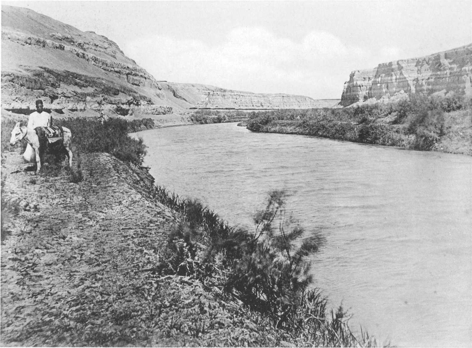
Plate V. ALLUVIAL DEPOSITS OVERLYING MARLY LIMESTONES (RAVINE BEDS) IN EL WADI, RAVINE NEAR QASR GEBALI.
The following is a section of the beds exposed in Wadi Muêla compiled from a paper by Mayer-Eymar on this oasis:—
Top. Metres.
Parisian. Id. White siliceous cavernous limestone with Lucina globulosa, Desh., Gisortia, Rostellaria, Eschara Duvali, Michelin., (Probably ≡ bed No. 1 of our J. Rayan section) 10
Greyish-yellow marl, rich in places with Ostrea Gumbeli, Pecten mœlehensis, May.-Eym., Vulsella chamiformis, May.-Eym., Velates Schmiedeli, Chemnitz, Cerithium fodicatum, Pleurotoma, Borsonia, Fusus, Rostellaria, etc. 6
Yellowish sandy marl, with small nummulites.
Ic. Yellowish marls, divided by one or two bands of red clay, with Nummulites gizehensis 7
Hard bedded clay 1
Vari-coloured gypseous marls 4
(Probably ≡ beds 2, 3, 4 at J. Rayan).
Ib. Very hard, rich greenish-grey, siliceous limestone with N. gizehensis, Pecten corneus, J. Sow., and Lucina (L. consobrina, Desh., and L. Defrancei, Desh.). 4 to 5
(Probably ≡ upper part of bed 5 at J. Rayan.)
There is a considerable difference in thicknesses between the above section and that of Jebel Rayan. Our heights agree closely with those of Schweinfurth, so that it is probable that Mayer-Eymar is in error, notwithstanding his challenge of Schweinfurth’s figures in the paper mentioned.
B.—Ravine Beds.
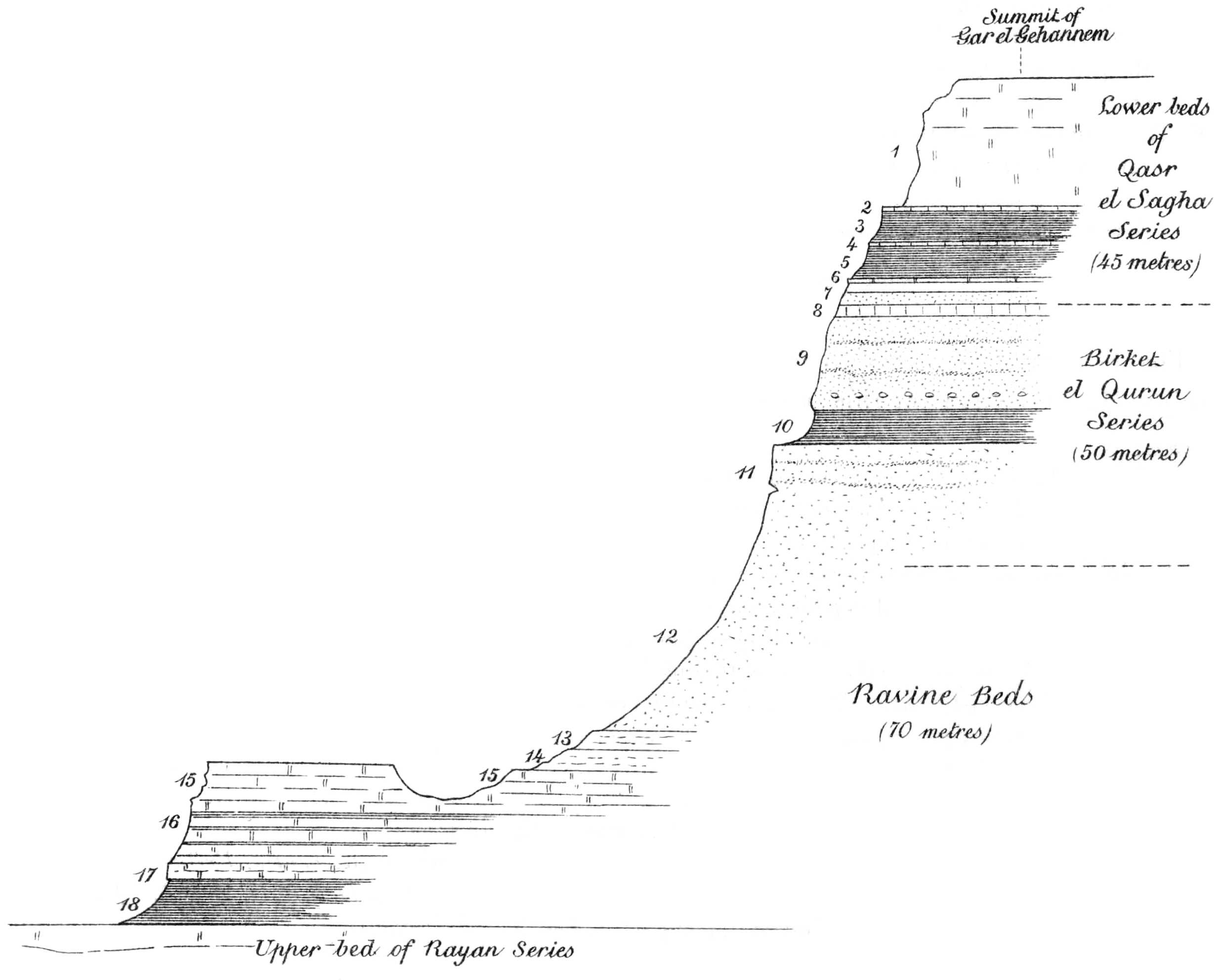
The beds of this series, consisting of gypseous clays, clayey marls, and white marly limestones, are met with bordering the cultivation on the east, west and north sides; they pass under the alluvial soil of the cultivated land and are frequently seen in the bottoms of canals, and especially in the deep ravines known as El Bats, and El Wadi (Plates III and V). The relation of these beds to the Rayan series below is well seen at the prominent outstanding hill Gar el Gehannem (Fig. 2); here the plain to the east and south is formed of the uppermost member of the Wadi Rayan series, a limestone full of Nummulites gizehensis. In the hill itself the latter is directly overlain by gypseous and glauconitic sandy clays and marls, with hard intervening beds of yellowish, often marly, limestone. The upper beds consist of alternating clays, sandy limestone and sandstone, at the top being a thick bed of the latter passing up gradually into the sandstones of the Birket el Qurûn series. The following is the detailed section:—
Summit of Gar el Gehannem. Thickness in metres.
1. Hard yellow and white limestone crowded with shells, chiefly large individuals of Carolia placunoides and Ostrea Fraasi. Numerous nummulites in upper part Lower beds of Qasr el Sagha Series (45 metres) 25
2. Limestone full of Turritella carinifera, Ostrea Clot-Beyi 1
3. Brown clays 6
4. Shelly limestone with Carolia, Turritella, Ostrea, Cardita and Qerunia (Hydractinia) 1
5. Greenish clays 6
6. Nummulitic limestone with Carolia, Qerunia and four species of Turritella 1½
Light blue clays 2
7. Light green and brown sandstone with irregular concretions 2½
8. Brown shelly limestone full of Carolia placunoides, Ostrea Reili, O. Fraasi, Turritella, Balanus and nummulites Birket el Qurûn Series (50 metres) 2
9. Yellow sandstone with bands of shelly limestone crowded with nummulites, oysters, etc. Near top casts of Cardita, Carolia; also Cerithium, Teredo, Ostrea, Pecten, Pinna, and echinids. Calcareous concretions near base 18
10. Clays with much gypsum 6
11. Yellow sandstone with Balanus. Bands crowded with two species of nummulites and occasional oysters. In places the foraminiferal bands become highly calcareous. Below similar, with hard compact grey bands and occasional fish-spines and teeth 24
12. Similar to above, with numerous casts of Cardita, etc., and small Ostrea Ravine Beds (10 metres) 24
Argillaceous sandstone with thick stockwork of gypsum and calcareous nodules 6
13. Light yellow, brown, and greyish gypseous clays 3
14. Yellow-brown sandstones and sandy limestones, often argillaceous. Fish-scales.
Brown clays
Yellow-white marls and marly limestone 5
15. Hard light yellow shelly limestone, in part marly, in part sandy 10
16. Ochreous-yellow, grey, and white clays and marls with gypsum 9
17. Hard yellow-white shaly marl with numerous shell-impressions; much gypsum 3
18. Yellow marly clays; soft yellow and grey-brown clays, dark sandy glauconitic, yellow, and black, clays. Zeuglodon remains fairly common. Shell impressions. Much gypsum
Fairly hard yellow-white glauconitic marl 10
Marly limestone with Nummulites gizehensis forming top of Rayan beds.
Fig. 2.—Section at Gar el Gehannem, showing the relation of the Wadi Rayan Series to the Ravine Beds.
The clays, marls, and limestones of the Ravine beds are generally found to contain fairly numerous shell-impressions, including Nucularia sp., Leda sp., Cardita sp., Corbula aff. pixidicula, Lucina sp., Oudardia ovalis, Desh., Tellina tenuistriata,[42] numerous small fish-scales, and occasional large teeth of sharks; while the skeletons of the toothed-whale Zeuglodon Isis are fairly common, although usually in poor preservation.
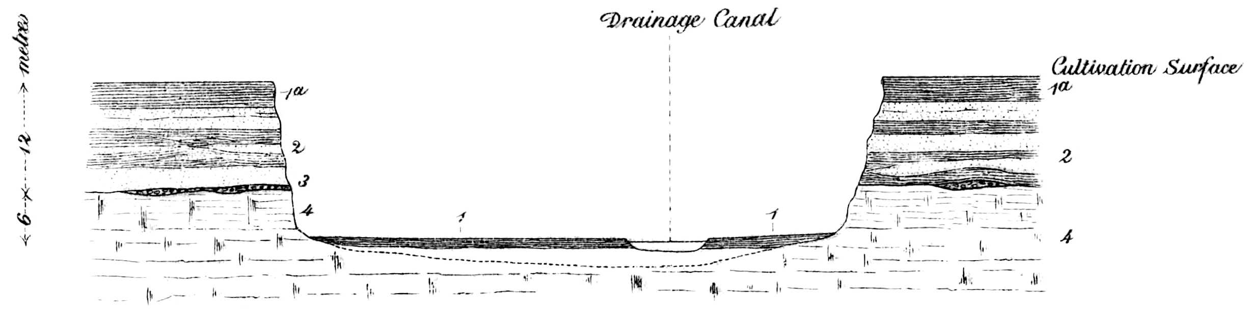
In the ravine of El Bats, about one kilometre west of Sêla, these beds (5-6 metres thick) are seen unconformably overlaid by 12 metres of false-bedded gypseous sands and clays passing up into the superficial cultivated loam. The junction of these alluvial deposits and the underlying Eocene is distinctly unconformable and an intervening pebble-bed is occasionally present (Fig 3).
In the large ravine known as El Wadi, which traverses the west side of the cultivation of the Fayûm, these beds are frequently well exposed; their lithological characters remain very constant. Here, as in El Bats, they are unconformably overlain by a varying thickness of Pleistocene and Recent clays. Their surface, a plain of subaerial denudation, represents the original floor of the depression before the entry of the sediment-carrying water from the Nile Valley through the Lahûn gap; its irregularity is seen in Plate V.
The plain bordering the cultivation to the east of Sêla and Rubiat likewise consists of these same white marls with fish-scales, etc.; they pass regularly under the cultivated land. Shaly marls, gypseous clays, and chalky limestones of the same age are seen in, and to the south of, the railway crossing the desert between Sêla and Medum. Eastwards they stretch into the Nile Valley, being found exposed along the desert-edge bordering the cultivation at Medum, Nawamis and Masaret-Abusia.
RECENT AND PLEISTOCENE 1. Marsh and poorly cultivated land. 1a Cultivated loam. 2. Sands and clays, with gravelly bands; often concretionary and gypseous beds. 3. Pebble-bed marking unconformable junction. MIDDLE EOCENE ⎱ ⎰ Ravine Beds ⎰ ⎱ 4. Gypseous saliferous marly clays, white marls and limestone with fishscales and Tellina Corbula, etc. Fig. 3.—Sketch-Section across El Bats, 1 kilometre West of Sêla.
The same beds are exposed immediately to the east of the village of Sersena, midway between Sêla and Tamia. They are again well seen in the ravine below the last named village, and forming the narrow strip of the desert projecting into the cultivation as far as the northern end of the Tamia lake; they also occur on the shore of the latter at El Tuba, about 2 kilometres south of the village. At Tamia their exposure measures 25 metres in thickness.
At various points along the north side of the Birket el Qurûn exposures of this series occur, the beds forming the lower sloping part of the cliffs overlooking the lake, as well as the base of the island “Geziret el Qorn,” although only the upper beds are visible above the water of the lake. Both here and along the northern shore of the lake they are for the most part hidden by the high level recent lacustrine clays, but where occasionally exposed their identity is certain, the characteristic small brown fish-scales being abundant, besides occasional teeth, with shell-impressions of the different genera enumerated above.
Plate VI. ESCARPMENT OF THE BIRKET EL QURUN SERIES NEAR THE WESTERN END OF THE LAKE.
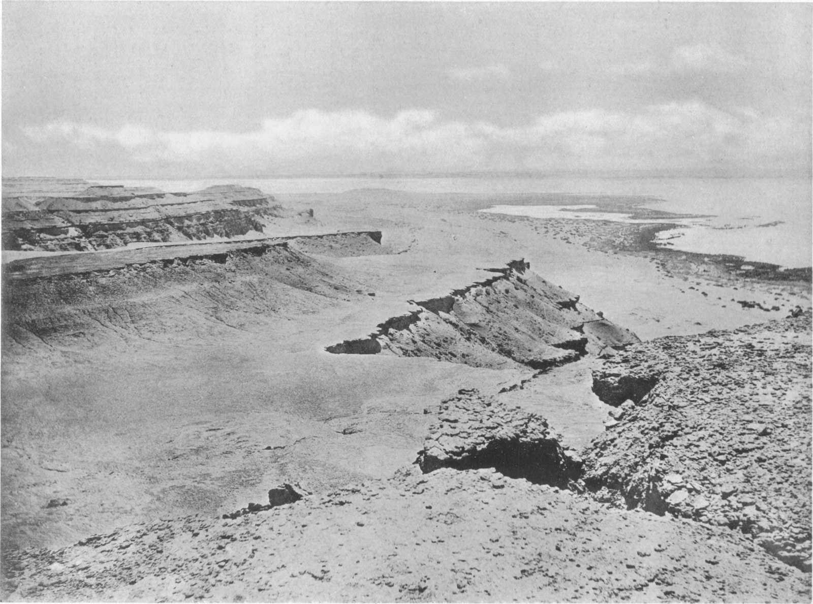
At the western end of the lake the Ravine beds form the lower part of the cliff as well as the plain to the south; the underlying Nummulites gizehensis limestone not being exposed. The series consists of some 45 metres of white and grey shaly marls with harder bands of siliceous limestone intercalated throughout, one of which usually forms the uppermost bed. It is, in fact, the development in places of one or other of these hard beds of limestone near the top of the series that gives rise to the bold promontories, or horns, which occur on the north side of the Birket el Qurûn.
The greater part of the marls and clays met with from 18·5 to 112·5 metres below the surface in the boring at Medinet el Fayûm in all probability belong to the Ravine beds.
The maximum thickness of this series is 70 metres, measured at Gar el Gehannem.
C.—Birket el Qurun Series (Operculina-Nummulite Beds).
The above designation is convenient and applicable to these beds, which form the escarpment immediately overlooking the lake on the north side throughout its length.
The group includes all the beds between those last described and the well-marked Qasr el Sagha series, homotaxial with the Upper Mokattam (the brown beds) of Jebel Mokattam, near Cairo. It thus appears to be the equivalent of the upper part of the white beds (quarried limestones) of the Mokattam section, although the lithological characters are entirely different, the massive limestones of Jebel Mokattam being represented in the Fayûm by an arenaceous and argillaceous series, deposited probably in water of far less depth. Where the different members of this series are well exposed certain beds are found to be characterized by the abundance of two foraminifera, the one a small thin-shelled Operculina (O. discoidea)., and the other a small thick nummulite.[43] The tests of these foraminifera sometimes make up entire bands of rock. In addition, the series includes certain beds which at times become very fossiliferous, and contain a well-preserved molluscan fauna.
The series is well seen in the desert separating the Fayûm from the Nile Valley; on the south-east and east sides of the former; along the northern boundary of the cultivation and the Birket el Qurûn; and westwards in the cliffs to beyond the outlying hill-mass of Gar el Gehannem.
The following section was measured on the south-west of the Fayûm, from Ezba Qalamsha (on the confine of the cultivation) to the ridge summit 5 kilometres to the south-east.
Top. Metres.
Summit of ridge 5 kilometres south-east of Ezba Qalamsha.
Pliocene Raised Beach with occasional Ostrea cucullata, Born., made up of gravels with blocks of limestone.
Birket el Qurun Series. 1. Ochre-coloured calcareous sandstone and sandy limestone crowded with foraminifera (Nummulites Fraasi, etc.), Ostrea, etc. 38
2. Sandy limestone, largely made up of foraminifera (Operculina discoidea ?) 2
3. Sandy shale 2
4. Sandstone, partly calcareous, with much gypsum 3
5. Calcareous sandstone with concretionary weathering 17
6. Shale with gypsum 2
7. Calcareous sandstone 4
8. Shale with gypsum 2
9. Calcareous sandstone, hard and yellowish 2
10. Gypseous shale with numerous small shells (Tellina sp.) passing down into sandy limestone. (This bed is the uppermost member of the Ravine beds) 6
Total thickness 78
Base, cultivation level.
To the north of the Lahûn pyramid the beds agree generally with the above. The following are the chief divisions here:—
Top of Hills. Metres.
Gravel Terrace (Pliocene) 22 metres thick.
1. Calcareous sandstone and sandy limestones full of nummulites; also Ostrea, etc. 31
2. Ochre-coloured calcareous sandstone or sandy limestone, often crowded with Operculina discoidea and some Nummulites Fraasi, etc. 12
3. Sandy limestone with small foraminifera at top and some shells. The upper part of this bed has been quarried 20
4. Shales and shaly limestone; gypsum —
Total thickness 63
The foraminiferal sandy limestones of this series are seen at points in the desert bounding the eastern margin of the cultivation, notably east of Sersena and at the top of the hill 15 kilometres north-east of Rubiat.
The following section was measured at the prominent hills 17 kilometres 28° N. of E. (magn.) of Tamia:—
Metres.
1. Greyish laminated sandy clays with gypsum; Ostrea band near top 7
2. White sandy limestone with numerous badly preserved Ostrea, Pecten, and other lamellibranchs 1
3. Dark-brown clayey sands with gypsum and grey sandy clays with obscure plant-remains. Occasional Ostrea 14
4. Hard, white, sandy limestone with numerous Ostrea at top; soft clays with gypsum 1
5. Greenish and brownish sands and sandy clays with band of sandy limestone near top ⎱ ⎰ 14
6. Greyish-brown, impure, sandy limestone weathering into large globular concretions. Shell impressions
7. Sandy clays and marls alternating with impure limestones; much gypsum. Occasional fish-remains and small oysters ⎱ ⎰ 22
8. Greenish sandy limestone with traces of shells
9. Finely laminated grey-brown clays with black carbonaceous matter and fish-remains; saliferous 3
10. White sandy limestone 1
11. Soft yellow sandstones, etc. ⎱ ⎰ 7
12. White marls with fish-scales, etc.; base not seen. (This bed, and possibly also 9, 10, 11, should be reckoned as belonging to the Ravine beds)
Total thickness 70
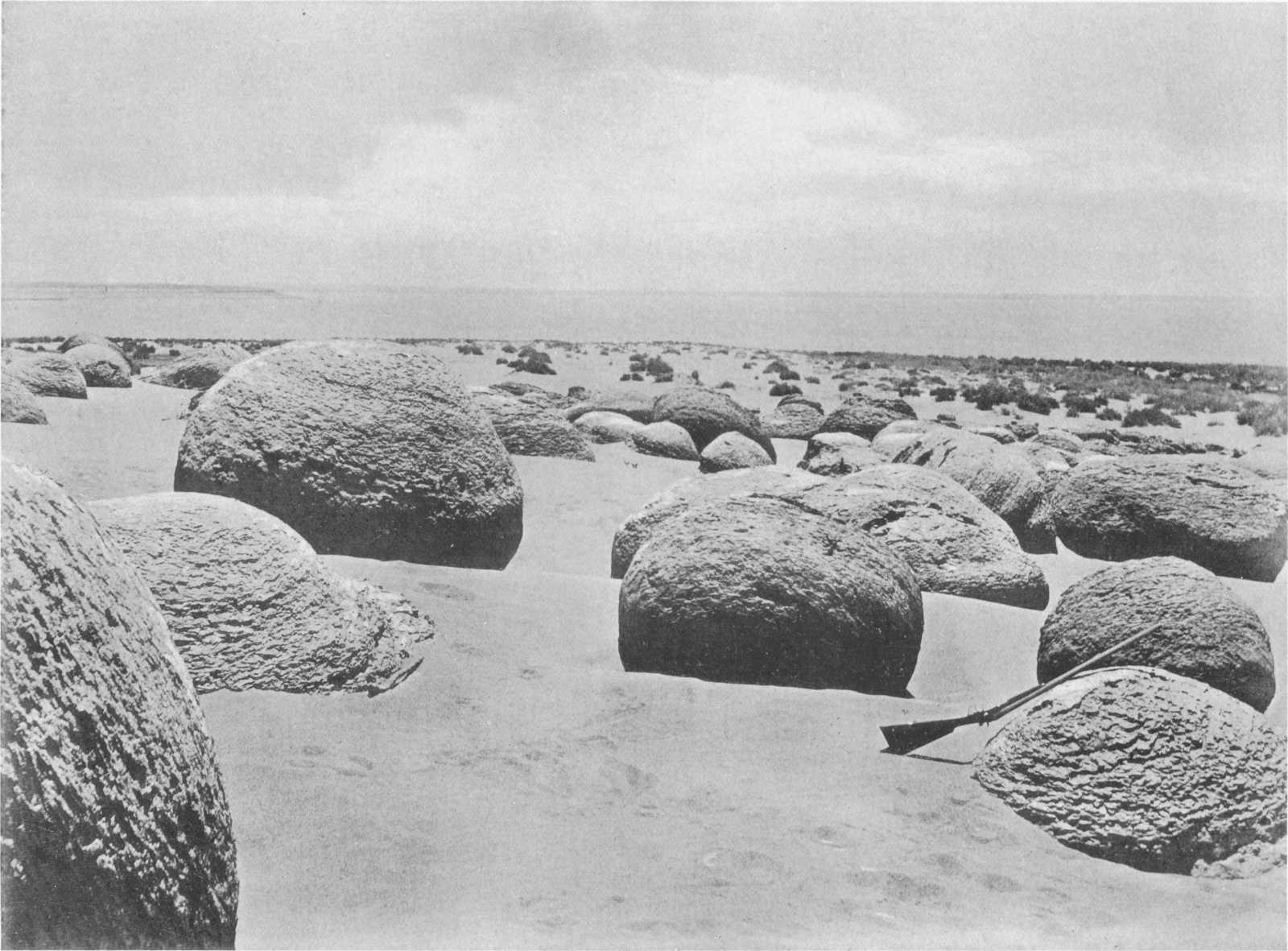
In the north of the Fayûm the series is characterized by the presence of one or more very constant well-marked beds of hard calcareous sandstone, which almost invariably weather into huge globular masses. These masses should be regarded as huge weathered-out concretions, rather than as water-rounded blocks, although no doubt in many cases their roundness has been increased by the action of the waters of Lake Moeris as the level of the latter gradually fell, and possibly still earlier during the invasion of the Pliocene sea; from the latter time also may date the millions of parallel vertical borings with which these and other exposed rocks are often perforated. In the various places where one of these beds forms the present surface of the desert the concretions may be seen in different stages of exposure, from the initial, where only just the tops are laid bare, to the final stage where the globes are left completely weathered out, as seen in the illustration (Plate VII). The appearance of the desert when covered for many square kilometres with thousands of these blocks is more easily imagined than described.
The lower beds of the Birket el Qurûn series form the island Geziret el Qorn, and consist of clays and sandstones containing a considerable number of organic remains. These beds were collected from and examined by Schweinfurth[44] in 1879, the mollusca being subsequently described by Mayer-Eymar,[45] while the vertebrate remains, which included cetacean bones and numerous fish-teeth, were submitted to Dames.
The following species were determined by Mayer-Eymar, who indicated that the fauna as a whole had a Bartonian aspect[46]:—
Upper Bed.
Ostrea plicata, Defr.
Arca Edwardsi, Desh.
Lucina pomum, Duj.[47]
Lucina cfr. tabulata, Desh.
Cardium Schweinfurthi, May.-Eym.
Cytherea Newboldi, May.-Eym.
Tellina pellucida, Desh.
Mactra compressa, Desh.
Corbula pyxidicula, Desh.
Calyptræa trochiformis, Lam.
Turritella angulata, Sow.
Ficula tricarinata, Lam.
Lower Bed.
Astrohelia similis, May.-Eym.
Goniastræa cocchii, d’Achiardi.
Heliastræa acervularia, May.-Eym.
Heliastræa Ellisi, Defr. (Astræa).
Heliastræa flattersi, May.-Eym.
Ostrea digitalina, Dubois.
Ostrea gigantea, Sol.
Ostrea longirostris, Lam.
Ostrea producta, Delb. et Raul.
Isocardia cyprinoides, Braun.
Turritella carinifera, Desh.
Turritella transitoria, May.-Eym.
Turritella turris, Bast.
Turbo Parkinsoni, Defr.
Pleurotoma, sp.
The cetacean remains, belonging to the genus Zeuglodon, were described by W. Dames,[48] who compared them with the American species Z. macrospondylus and Z. brachyspondylus, but did not then consider them to represent a new species; in a later publication,[49] however, the same author described similar but more complete remains, also collected by Schweinfurth (from beds belonging to our Qasr el Sagha series), as a new species, Z. Osiris. A considerable number of fish-remains from Geziret el Qorn are also described in the earlier publication. Although the difference in size of the bones of separate individuals was considered by Dames to be sexual, it seems probable that there are two distinct species of Zeuglodon, as the smaller type appears to have a much greater upward range than the larger[50]; both species, Z. Osiris, and Z. Isis occur in the Birket el Qurûn series, and a very fine mandible of the larger was obtained from these beds in the cliffs near the west end of the lake.[51] More recently a third species has been discovered by Stromer and described under the name of Z. Zitteli.[52]
Fig. 4.—Profile of beds of Geziret el Qorn. 1. Hard brown sand-rock with large concretions of weathered globular sandstone on the summit; ferruginous nodular bands containing shell-casts occur near top. 2. Soft gypseous clays with bands of sand-rock and sandstone with Ostrea, Cardium Schweinfurthi, Turritella, corals, Zeuglodon, chelonian and fish-remains. 3. Brown sand-rock. 4. Soft gypseous clays and harder brown sandstones. 5. White shaly marl with fish-scales; hard band at top and soft sandy shaly clays below. The surface-slope is much less than shown in sketch and is generally covered by a deposit of lacustrine clays containing freshwater shells and fish-bones.
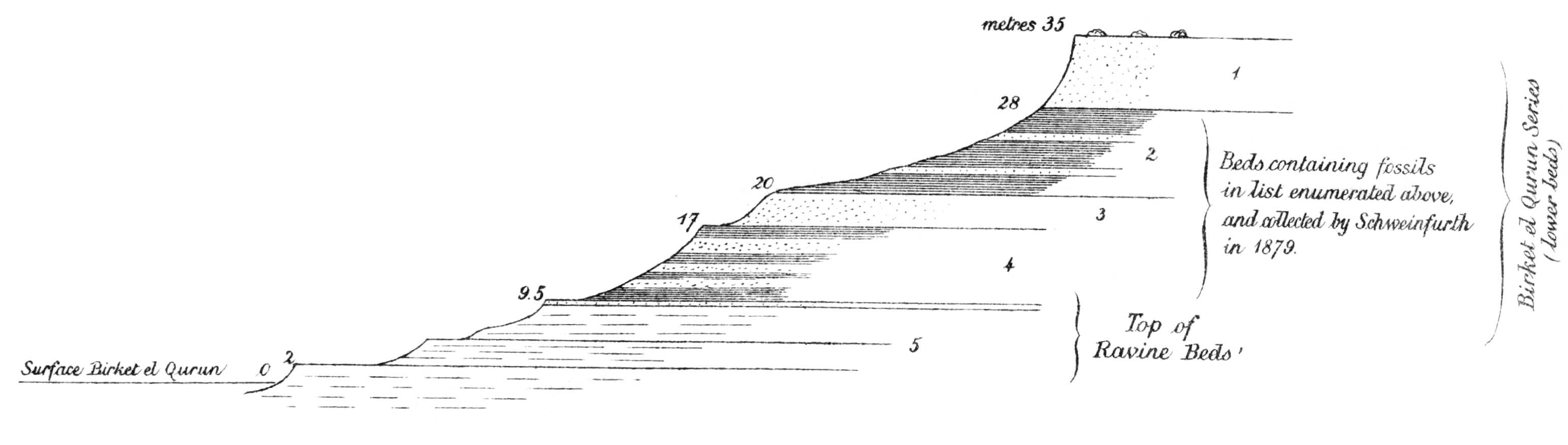
The accompanying profile (Fig. 4), measured during a hurried visit to the island for the purpose of correlating these beds with those of the mainland, shows the character of the lower beds of the Birket el Qurûn series at this point.[53]
Plate VII. WEATHERED CONCRETIONARY SANDSTONE (BIRKET EL QURUN SERIES) ON NORTH SHORE OF LAKE NEAR GEZIRET EL QORN.
The upper beds of the Birket el Qurûn series in this part of the Fayûm are lithologically similar to those just described, consisting of alternating clays and sandstones, about 37 metres thick. They are, however, generally much richer in fossil remains, which are likewise usually better preserved than in the lower beds. Some of the brown sandstones of this series are literally crowded with perfect examples of many of the typical mollusca; and further west, near the end of the lake, foraminiferal bands again become noticeable. Near Dimê the escarpment of these and the lower beds is gentle and inconspicuous, but followed westwards it becomes a bold precipitous cliff, increasing in height towards the western end of the lake, where it is capped by the lower beds of the Qasr el Sagha series.
The following section was measured on the mainland[54] opposite the island Geziret el Qorn.
Top. Metres.
1. Gypseous clays, separated by a band of brown sandstone crowded with white well-preserved shells, including numerous individuals of Plicatula polymorpha, Ostrea, Turritella and Lucina pharaonis. Large vertebrae of Zeuglodon Isis occur on this horizon further to the north-east 8
2. Sandstones and gypseous clays. Although here the sandstones are not hard or predominant, this bed is equivalent to the hard sandstone full of borings capping the plain between the ruins of Dimê and the top of the escarpment overlooking the lake. Further north this bed often contains numerous Carolia placunoides and Ostrea 3
3. Gypseous clays 3
4. Clays, brown sandstones, and occasional beds of limestone, often very fossiliferous, containing Ostrea Reili, Carolia placunoides, Cardita Viquesneli, d’Arch., Lucina sp., Turritella pharaonica,[55] Clavelithes longævus, Qerunia cornuta, etc., etc. 10
5. Clays with fossils as in last bed, capped by hard band of shelly sandstone 3
6. Alternating yellow-brown sandstones and gypseous clays 10
Total thickness 37
Bed with weathered-out sandstone concretions at top—upper bed of section at Geziret el Qorn.[56]
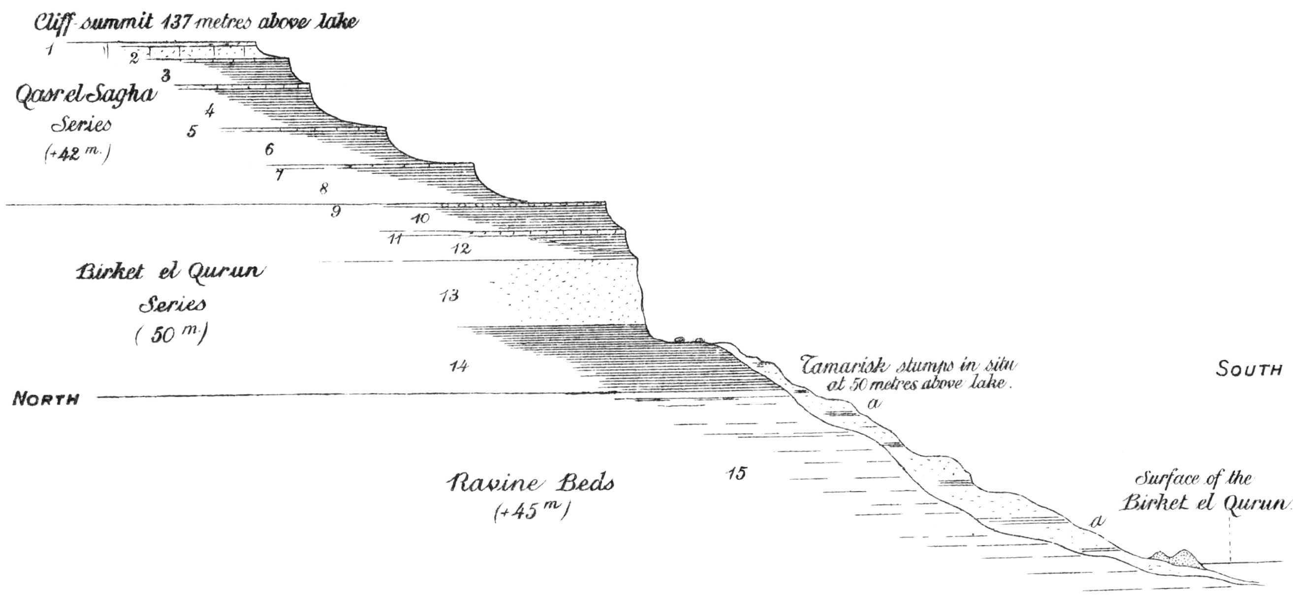
At the western end of the Birket el Qurûn the series is well marked, the sandstone beds forming the steep face of the bold precipitous cliffs which are so marked a feature at this end of the lake. The group has a thickness of some 50 metres and is overlain by the lower beds of the Qasr el Sagha series; it is more convenient here to give the entire section of the cliffs down to the base of the series under discussion:—
Top of Cliffs. Metres.
1. Hard grey sandstone and shelly limestone passing up into calcareous sandstone (forming surface of plain dipping north). Lower part (42 metres) of Qasr el Sagha Series.
2. Impure sandstone with numerous fossils:—Qerunia cornuta, corals, Ostrea Reili, O. Clot-Beyi, Carolia placunoides, Plicatula polymorpha, Cardita (? fajumensis) sp., Clavelithes longævus, Serpula, etc.
3, 4. Clays with band of argillaceous sandstone. Septaria bed near base. Fish-remains.
5. Earthy limestone crowded with Ostrea Clot-Beyi, O. sp., Plicatula polymorpha, Pecten sp., Lucina sp., Cytherea sp., Turritella sp., Nonionina sp., Oliva sp., Pleurotoma sp., Vermetus sp., Nautilus sp.
6. Thin-bedded clays, grey with yellowish band, sandy clays interbedded with soft whitish sandstones with small irregular concretions. Clays, gypseous and sometimes carbonaceous.
7. Shelly sandstone, hard on upper surface and very fossiliferous (forms similar to Bed 9).
8. Gypseous clays.
9. Thin (·25 to ·5 metre) hard dark reddish-brown, very ferruginous, concretionary-weathering sandstone with nummulites and Operculina and well-preserved examples of Qerunia cornuta, Pecten sp., Pectunculus sp., Venus sp., Cardita Viquesneli, Astarte sp., Macrosolen Hollowaysi, Lucina sp., Natica sp., Cerithium sp., Clavelithes longævus, Voluta sp., Dentalium sp. 1
10. Hard purplish clays 7
11. Soft yellowish sandstone with Ostrea sp., Cardita ægyptiaca, Lucina sp., Turritella sp., and sharks’ teeth. Upper surface tends to become dark, ferruginous, and concretionary 1
12. Purple clays, with strings of gypsum 6
13. Soft light-yellow sandstones with harder shelly bands and occasional concretionary beds, forming vertical cliff-wall 17
14. Grey and brown clays 18
Ravine Beds. Total 50
In the cliffs west of the end of the lake the upper bed No. 9 continues highly fossiliferous and yields the most perfectly preserved molluscan remains to be found in the Fayûm and probably in Egypt.
A few kilometres east of the end of the lake a band of large globular concretions occurs in the thick brown sandstone forming the vertical face of the cliff. In many places the effect of weathering of these rocks is of some interest, numerous “earth-pillars” having been formed; these are largely the result of the action of blown sand, assisted by rain, the concretions being left capping pillars of brown sandstone, the sides of which are sculptured by the wearing action of sand. The curious perforate or cellular appearance which the weathered surfaces of this sandstone assume after long exposure are particularly noticeable in this neighbourhood and in the Zeuglodon Valley further west.
In the well-marked hill distant 17 kilometres to the north-east of Gar el Gehannem, the soft fossiliferous sandstones of this series are crowded with Operculina, Nummulites, and many species of mollusca beautifully preserved.
At Gar el Gehannem the series is seen (Fig. 2 and detailed section page 36) forming part of the slope of the hill, underlain by the Ravine beds, and capped by part of the Qasr el Sagha series. It here consists of yellow sandstones divided by a bed of clay; the sandstones are often crowded with nummulites (of two species); also Operculina (discoidea?), echinids, Balanus sp., Ostrea Reili, O. Fraasi, Carolia placunoides, and species of Pecten, Pinna, Cardita, Teredo, Turritella, and Cerithium.
Fig. 5.—Section of cliffs, western end of the Birket el Qurun. Pleistocene.—(a) Lacustrine clays and sands with freshwater shells and fish-remains; Middle Eocene, 1. 14 Clays, sandstones and impure limestones; 15 White shaly clays and marly limestones.
In the Zeuglodon Valley, 12 kilometres W.S.W. of Gar el Gehannem, the brown sandstones of the Birket el Qurûn series are divided by a narrow band of fine-bedded grey clay. Most of the fantastically shaped hills on the south-west slope of the valley are carved out of the lower division of the sandstone. The concretionary beds of the Birket el-Qurûn series are not developed in this neighbourhood. Remains of Zeuglodon of both species (Z. Osiris and Z. Isis) are remarkably abundant and the skeletons of these cetaceans may be found in every stage of weathering. The larger species, Z. Isis, is the more common, and series of vertebrae, twelve to fifteen in number, can frequently be counted in situ. The remains are most abundant enclosed in the hard brown nodular bands of the series but in such cases it is almost impossible to extract specimens of any value. In one instance an almost complete skull of Z. Isis, measuring 116 cm. in length, was found enclosed in a large block of the nodular rock.[57] Bones are frequently to be observed protruding from the wind-worn sides of the small hills, while those portions of the skeleton already weathered out litter the ground below. Exposed they break up with rapidity, although where the enclosing rock is softer than the bone itself, parts of the skeleton beautifully preserved and perfectly free from matrix may sometimes be obtained.
The molluscan fauna is represented by very large numbers of pseudomorphs in sulphate of strontium (celestine) of the genera Lucina, Turritella, Fusus and Nautilus, the profusion of individuals of a species of the latter being very marked. In the case of lamellibranchs the radiating bundles of crystals of celestine are seen to originate from a point placed centrally on one of the valves, so that on this side (of a slightly weathered example) a radiating mass of crystals is seen, while on the other appear numerous contiguous circular areas, representing the terminal ends of the bundles of crystalline fibres or needles. Apart from the quantities of organic pseudomorphs, masses of crystalline celestine occur in the sandstones throughout the valley, and altogether the quantity of sulphate of strontium present must be very great. The gigantic oysters and other fossils which occur in some of the overlying higher beds, and the numerous individuals of nummulites in the sandstone itself, never seem to be replaced by celestine.
Nummulites of two species are very abundant in some bands and the presence in the Zeuglodon Valley of occasional individuals of the large N. gizehensis shows that in favourable localities this species persisted throughout the time represented by the deposition of the Ravine beds and ranged upward into the basal members of the Birket el Qurûn series.
In the higher hills within the valley, and in the hill-mass on the south side, the yellow sandstones of the Birket el Qurûn series pass up into the basal members of the Qasr el Sagha series. In their upper limits the sandstones become very nummulitic in places and at the top bands made up of Carolia and Ostrea occur. Above these, in the basal members of the Qasr el Sagha series, huge oysters and finely preserved specimens of Qerunia cornuta are conspicuous.
The dip in the valley is 2° north.
The southern face of the hill-mass lying immediately to the south of the Zeuglodon Valley is an almost sheer cliff of over 100 metres, descending to the silt covered basin below which has already been noticed (page 23). On this escarpment the hard nodular marly limestones of the Ravine beds are seen near the base, overlain by a mass of grey shaly gypseous beds; above, forming as a rule a vertical wall of rock, lies the hard massive brown sandstone of the Birket el Qurûn series, here undivided by clays; at the top, highly fossiliferous alternating clays and limestones are found forming the summit of the hills.
The exact junction between the Birket el Qurûn series and the overlying Qasr el Sagha beds is naturally perfectly arbitrary, many of the fossils being common to both groups. Carolia placunoides, which is perhaps the most abundant fossil in the Qasr el Sagha series, is sometimes very common in the upper beds of the underlying group, and, as shown before, is common enough in the still lower Nummulites gizehensis beds of Wadi Rayan. So that, though this fossil itself is no criterion, its relative abundance in the upper series justifies those beds being called the “Carolia beds,” the additional name of the Qasr el Sagha series being taken from the old ruin of that name where these beds are fully seen.
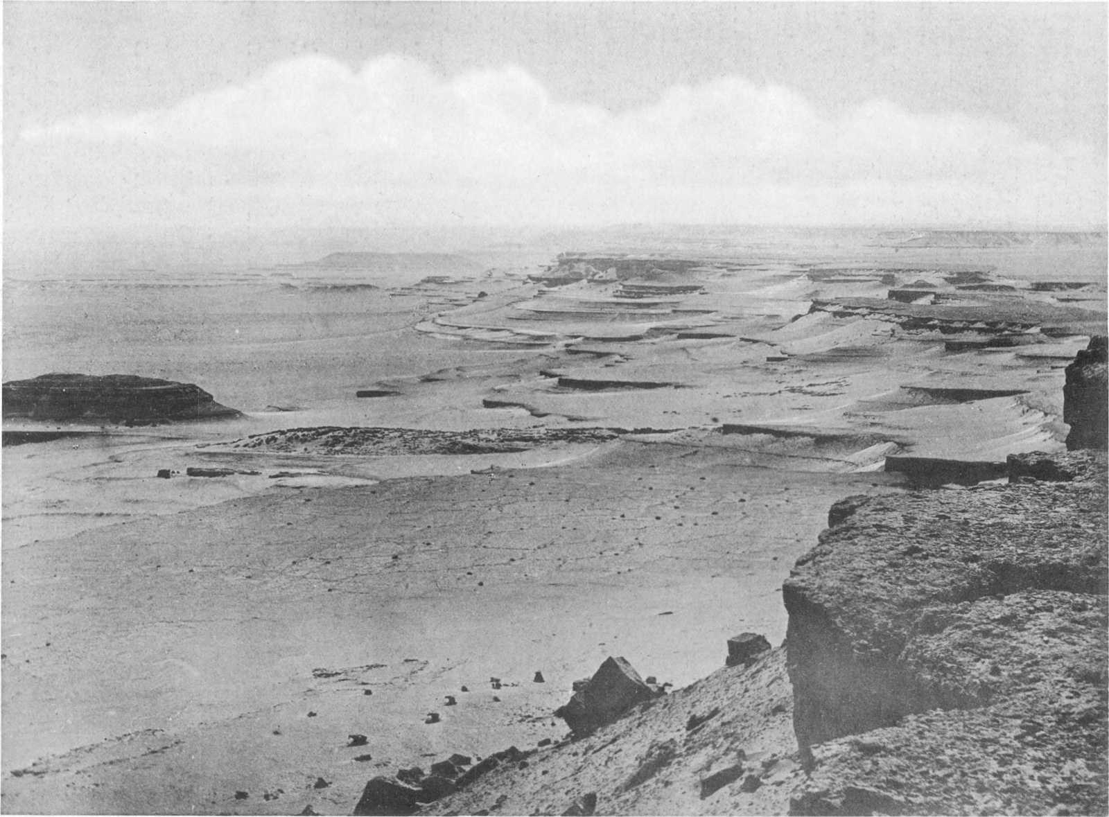
Plate VIII. MIDDLE EOCENE ESCARPMENT (QASR EL SAGHA SERIES) 12 KILOM. WEST OF QASR EL SAGHA.
D.—Qasr el Sagha Series (Carolia Beds).
This division is strikingly developed in the north of the Fayûm, where it forms a bold escarpment of great length, consisting of an alternating series of very fossiliferous clays and limestones, with sands and sandstone in the upper beds, of a total thickness of 175 metres.
This series is the equivalent of the well known Upper Mokattam beds of Jebel Mokattam, immediately to the east of Cairo. The cliffs of this hill are among the best known in Egypt and have been studied by many geologists, including Zittel, Schweinfurth, Mayer-Eymar, etc.; these authors have classified the whole of the Upper Mokattam of Cairo as equivalent to the Upper Parisian (Middle Eocene) of Western Europe. The series is far better developed in the Fayûm than at Jebel Mokattam, where the total thickness is only some 70 to 80 metres.
In consequence of the discovery in these beds of a highly interesting vertebrate fauna, including land animals, the series becomes of the greatest importance. As already mentioned, as long ago as 1879, Schweinfurth, during a journey across the Fayûm, obtained remains of Zeuglodon in the underlying series from the island in the Birket el Qurûn. Subsequently[58] he obtained additional remains of the same cetacean in a violet marl belonging to the present series, from a locality 12½ kilometres west of Qasr el Sagha[59]; these remains, as already mentioned, were described by Dames as Z. Osiris. Since then important finds of land and marine mammals and reptiles have been made in different beds of this series; these will be referred to later.
The outcrop of the Qasr el Sagha series occupies a large part of the northern desert of the Fayûm. The beds are, however, best seen in the cliffs about 8 kilometres north of the Birket el Qurûn, where they form a steep double escarpment, running east and west, nearly parallel to the northern shore of the lake. The dip of the series being northward at a very low angle, and the upward slope of the ground being in the same direction, this cliff dies out a few kilometres north-east of Qasr el Sagha. A little further north, however, a N.W.-S.E. fold and fault again exposes nearly the whole of the beds of the series, forming prominent cliffs as before.
In the conspicuous hill 17½ kilometres 28° N. of E. (magnetic) of Tamia the series consists of innumerable alternations of clays and sandy limestone. The calcareous beds nearly always contain numerous examples of Carolia placunoides, Ostrea and Turritella of several species, but other well-preserved fossils are rare. The exposed beds here have a thickness of about 55 metres, and are underlain by the Birket el Qurûn beds with a well-marked band of concretionary sandstone, the thickness of the two series together being 127 metres. The upper beds of the former series are not here exposed, the top of the hill being formed of well-rounded flint and quartz pebbles embedded in a base of finely crystalline gypsum (2 metres thick), a deposit of Pleistocene times.
To the north of Tamia a large area of desert is occupied by the beds of this series; the district has the character of an undulating plain with occasional groups of hills and low irregular escarpments. At the groups of hills 12 kilometres N.N.E. of Tamia, and just to the east of Garat el Faras, the Qasr el Sagha beds are found to consist as usual of an alternating series of sands, sandstones, clays, marls and limestones, with numerous individuals of Ostrea, Carolia and Turritella, besides vertebræ, teeth and spines of large fish.
We may pass now to the locality where this series shows its best development and exposure, the beds being all concentrated in one bold escarpment, generally divisible into an upper and a lower cliff. These cliffs overlook the Birket el Qurûn, although distant usually about 8 kilometres, being separated from the lower escarpment of the Birket el Qurûn series (immediately above the lake shore) by a broad plain, the surface of which is usually the dip-slope of a hard bed of sandstone. From Qasr el Sagha (6½ kilometres N.N.E. of Dimê) these cliffs trend westward, keeping approximately the same distance from the north shore of the lake; they have been followed and mapped for a distance of 70 kilometres to a point 13 kilometres N.N.W. of Gar el Gehannem, whence they could be seen still trending in a direction slightly south of west (see Plate XVII).
Small faults are of frequent occurrence along these escarpments, but are not of other than local interest; they almost invariably have their downthrow to the north, and it seldom exceeds a few metres. Fig. 5 shows a section through one of these faults near Qasr el Sagha.
The following detailed section (Plate XXIII) will show the character of the beds forming this division. As might be expected in such a series, although the calcareous bands are fairly constant, there is a continuous change of character among the sandy and clayey sediments from point to point; the false-bedding is in places very striking.
The main part of the section was measured 3½ kilometres north-east of Qasr el Sagha, but the lower beds not being exposed at that point, they were added from the cliffs at the ruin itself. The total thickness is 154 metres.
Top. Thickness in metres.
1. Hard, white, grey-weathering, sandy limestone with numerous shell-casts: Echinolampas Crameri, Loriol, Plicatula Bellardi, May.-Eym. 2
2. False-bedded sand and sand-rock with grey and green clays; concretions and bands of ironstone.
Hard, dark-brown or purplish ferruginous sandstone band. Occasional vertebrae of Zeuglodon Osiris, Dames, Pterosphenus (Mœriophis) Schweinfurthi, Andr., crocodilian and fish-remains; coprolites 16
3. Hard, calcareous, ferruginous, clayey sandstone with brown ironstone concretions. Occasional fish-spines.
Clays with massive veins of gypsum forming a stock-work, and left weathered out above surface. Cardium Schweinfurthi, May.-Eym., Cardita fajumensis, Oppenh., (Cossmannella ægyptiaca, May.-Eym[60]), Crassatellithes sp. 9
4. Hard, yellow, gypseous sandy limestone or calcareous sandstone 1½
5. Sandy, glauconitic clays with gypsum; oyster-bed at base in places. Alectryonia Clot-Beyi, Bellardi, Exogyra Fraasi, May.-Eym. 10
2nd escarpment.
6. Hard or friable limestone, sometimes sandy, full of Carolia placunoides, Cantr., and Exogyra Fraasi, also Ostrea aff. heteroclyta, Defr., Ostrea Reili, Fraas., O. elegans, Desh., Plicatula Bellardi, May.-Eym., Pectunculus (?) ægyptiacus, Oppenh., Qerunia (Hydractinia) cornuta, May.-Eym. 2
7. Purplish clays interbedded and remarkably current-bedded with ash-grey sands, with both ferruginous and highly carbonaceous bands with plant-remains, lignite and natural charcoal. Vertebrate remains fairly common, the mammalian including Zeuglodon Osiris, Eosiren libyca, Andr., Mœritherium Lyonsi, Barytherium? Andr.; the reptilian Stereogenys Cromeri, Andr., and Tomistoma africanum, Andr., with numerous coprolites; also frequent remains of siluroid and other fish. Masses of coral, Astrohelia similis, Felix, in places 12
8. Hard grey, close-grained, concretionary sandstone, frequently weathering into huge elongated rounded masses; Turritella pharaonica, Cossm.
Hard, purplish clays with grey sandy clays, sandrock, etc. Occasional crocodile and fish-remains 4
9. Hard ripple-marked sandstone. False-bedded sandstones with clay partings; ferruginous and lignitic bands with lumps of lignite. Occasionally coprolites and remains of Sirenia and Crocodilia are numerous 7
10. Hard or friable brown sandy limestone with shell-casts filled with scalenohedra of calcite. Carolia placunoides, Turritella sp. ½
11. Gypseous clays, with red ferruginous band; weathering to paper-shales below 4½
12. Light-yellow limestone and calcareous sandstone with sharks’ teeth, Mesalia fasciata, Lam., Cassidaria sp., Rimella rimosa, Sol., Trachelochetus bituberculatus, Cossm., Turritella carinifera, Desh., T. Lessepsi, May.-Eym., Cardita fajumensis, Oppenh. Goniopora? 1
13. Slate-blue and brown gypseous clays with band containing Mesalia sp., Cassidaria nilotica, Bell., Exogyra Fraasi and Goniaræa elegans 3
14. Sandstone and sandrock, light yellow 1
15. Yellow sandy friable limestone with casts of shells and Mesalia fasciata, M. oxycrepis, May.-Eym., Turritella Lessepsi, T. pharaonica, Cossm., Alectryonia Clot-Beyi, Ostrea Reili ½
16-17. Sands, sandy clays and clays with a double band of limestone containing Ampullina hybrida, Lam., Melongena nilotica, var. bicarinata, May.-Eym., Tudicla aff. umbilicaris, May.-Eym., Turritella Lessepsi, T. parisiana, May.-Eym., Solarium sp., Alectryonia Clot-Beyi, Plicatula polymorpha (occasional), Lucina fortisiana, Defr., L. pharaonis, Bell., Mytilus affinis? J. and C. Sowerby, Astrohelia similis, Goniaræa elegans, Mich.; numerous vertebrate remains both above and between limestones including Zeuglodon Osiris, Eosiren libyca, Barytherium grave, Andr., Moeritherium Lyonsi, M. gracile, Andr., Gigantophis Garstini, Andr., Pterosphenus Schweinfurthi and Tomistoma africanum, Andr. The remains of a siluroid fish are abundant; also Propristis Schweinfurthi, Dames. Large numbers of coprolites. Silicified wood 12
18. Brown sandy limestone with casts of shells, Akera aff. striatella, Lam., Ampullaria, n. sp., Gisortia gigantea, Munst., Lanistes antiquus, Blanck., Melongena nilotica, var. bicarinata, Mesalia sp., Cassidaria nilotica, C. aff. nodosa, Solarium aff. bistriatum, Desh., Alectryonia Clot-Beyi, Cardium Schweinfurthi, Exogyra Fraasi, Lucina pharaonis, Bell., Macrosolen Hollowaysi, J. Sowerby, Meretrix nitidula, Lam., M. parisiensis, Desh., Ostrea flabellula, Lam., Tellina sp., overlying clays with gypsum 4
19. Sandy limestone with numerous Carolia placunoides and Turritella imbricataria, Lam. 1
20. Greyish-blue and brown ferruginous, sandy, and other clays. Plant remains 13
21. Friable shelly limestone with occasional small calcite veins ½
22. Clays 4
23. Hard yellow sandy limestone with Ostrea and Anisaster (Agassizia) gibberulus ½
24. Clays with thin bands of fibrous gypsum 6
25. Hard friable shelly limestone with numerous fossils, including Dictyopleurus Haimi, Dunc. and Slad.; Akera aff. striatella, Turritella carinifera, T. imbricataria, T. pharaonica, Alectryonia Clot-Beyi, Arca tethyis, Oppenh., Cardita aff. carinata, J. Sowerby, C. aff. depressa, Locard., C. aff. triparticostata, Cossm., C. cf. gracilis and depressa, Locard., Cardita fajumensis, Cucullæa aff. crassatina, Lam., Exogyra Fraasi, Glycimeris (Pectunculus) pulvinatus, Lam., Ostrea aff. Reili, Spondylus ægyptiacus, Bull. Newt., Pecten solariolum, May.-Eym., P. moelehensis, May.-Eym., Qerunia cornuta, Euspatangus cairensis, Loriol, Linthia sp., Anisaster gibberulus, Schizaster aff. africanus, Loriol; bryozoa ½
26. Sandy clays with gypsum 7
27. Friable, gypseous, impure limestone with Exogyra Fraasi, Carolia placunoides, Turritella sp., Qerunia cornuta, Alectryonia Clot-Beyi ½
28. Sandy gypseous clays 3
29. Friable sandy limestone with Carolia placunoides, Exogyra Fraasi, Turritella sp. (The ruin of Qasr el Sagha is built on this bed) 1
30. Gypseous sandy clays with occasional oyster-limestone with Qerunia cornuta; ferruginous sandstone band, etc. 27
Total 154
Hard grey sandstone with Zeuglodon and numerous Carolia, Ostrea, etc., in places, capping plain to south of Qasr el Sagha and forming the top of the “Birket el Qurun series.”
The chief divisions of the series remain fairly constant and can be recognized and followed for many kilometres westwards.[61] The lower beds form the summits of Gar el Gehannem and the neighbouring hills (see Fig. 2 and section p. 36), the upper beds of the series being exposed in the higher escarpments to the north.
Although vertebrate remains are more common on some horizons[62] than on others, they are occasionally met with in most of the beds. The most prolific bone horizon is, however, about half-way down, i.e., those beds numbered 16 and 17 in the above section; bed 7 also yielded a number of remains. At the point where the upper part of the section was measured, 3½ kilometres north-east of Qasr el Sagha, the beds 16 and 17 yielded a considerable number of land-animal remains, all of which occurred within a fairly confined space, suggesting that they had been carried out from the land to this point by a strong river-current and deposited when the latter became too feeble to carry them further out to sea. The same beds were also examined in the faulted bay 8 kilometres to the north, but no bones, or at most a very occasional fragment or two, were obtained here. This is easily explained by the greater distance of this locality from the land-mass to the south. Westwards the same beds were always found more or less bone-bearing, isolated detached mandibles, limb-bones and vertebræ of Mœritherium, being of frequent occurrence, although no such complete remains were found as those from near Qasr el Sagha. Reptilian and fish bones are very widespread throughout the area. An extensive and detailed examination of these beds over a large area can hardly fail to yield important results, as other localities where skeleton-carrying currents came out from the land would very likely be discovered.
That the Qasr el Sagha series was deposited in fairly shallow water at no great distance from land seems certain, not only from the general lithological character of the beds but from the number of land-animal remains and the frequency of river and shore-frequenting whales, dugongs, crocodiles and turtles. The clays, moreover, are found to abound with impressions of plants, and in some cases are highly lignitic, being made up of compressed masses of vegetation including solid twigs, now found in a state more resembling charcoal than ordinary dense lignites; some bands approximate to an impure brown coal. In certain beds of the series further to the west, very thin seams of true coal occur; they were, however, never seen to exceed one or two millimetres. The intercalated bands of limestone are generally impure and do not indicate any great conditions of depth, but only rather a temporary cessation in the supply of sand and clay. Corals, moreover, abound along many horizons.
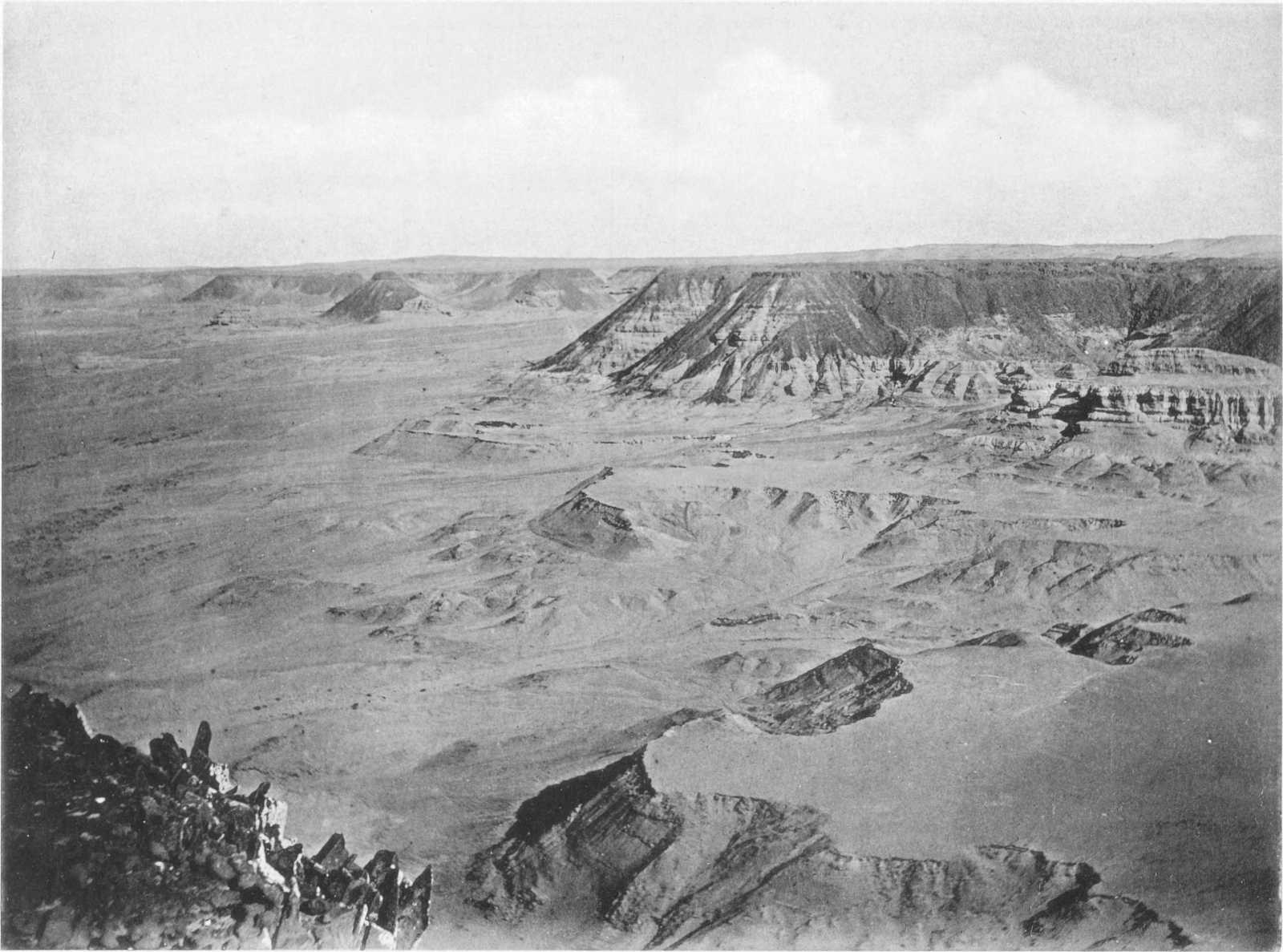
Plate IX. UPPER BEDS OF FLUVIO-MARINE SERIES WITH BASALT CAP, LOOKING WEST FROM THE EASTERN EXTREMITY OF JEBEL EL QATRANI.
Section XI.—UPPER EOCENE (BARTONIAN)—LOWER OLIGOCENE.
E.—Fluvio-Marine Series (Jebel el Qatrani Beds).
Throughout the north of the Fayûm depression the Qasr el Sagha beds, forming the uppermost Middle Eocene, are followed by an unique series[63] of variegated[64] sands and sandstones, with alternating beds of clay and clayey marl. The ever-recurring bands of limestone, so common to the underlying marine beds, have now almost completely disappeared, being represented by only an occasional bed of calcareous grit, marl, or thin band of limestone. In the upper part of the series occurs a horizontal sheet of basalt,[65] in all probability contemporaneously interbedded; this forms a convenient datum line and may perhaps be provisionally taken as an arbitrary junction between the Eocene and Oligocene. Although as a rule remarkably barren of organic remains, certain bands, especially in the upper part, yield numerous individuals of a few species of mollusca, including Lucina, Arca, Mutela, Spatha, Unio, Lanistes, Turritella, Melania, Potamides, Cerithium and Pleurotoma. From such an assemblage we may without doubt conclude that the conditions under which the series was deposited were estuarine or fluvio-marine, and this is further proved by the non-marine lithological character of the beds. The enormous quantities of silicified wood which occur in certain beds, in the shape of hundreds of trees of great length and girth, together with the numerous remains of land-animals, crocodiles, tortoises and turtles, indicate that rivers of considerable size emerged from the land to the south, the coast-line of which was probably not far distant. In fact the retreat of the sea, which as already mentioned, had probably already begun in Middle Eocene times, was now still further continued, although the cause of this was apparently not so much due to elevation of the land as to the continued deposition of sediment from south to north beyond the land-shore. We may in fact regard the series as a huge delta deposit in an area of local depression, in which the great accumulation of sediment brought down from the land continually caused the gradual retreat of the sea to the north.
The same conditions would even appear to have continued on to Pliocene times, as from the Fayûm northwards stretches an immense plain of lithologically similar rocks, evidently accumulated under similar conditions, and which appear to contain newer and newer faunas from south to north. Thus, while in the Fayûm the remains are of Middle and Upper Eocene and Lower Oligocene age, when the latitude of Mogara is reached, some 70 kilometres further north, a fauna distinctly Lower Miocene in aspect occurs; further north again, as at Wadi Natrûn, Pliocene remains are abundant. We may hope therefore that this otherwise barren desert, when carefully and systematically explored, will yield us a continuous record of the vertebrate life of the northern part of the African continent from Eocene to Pleistocene times.
In the Fayûm, over a length of 80 to 90 kilometres, the basal beds of the Fluvio-marine series, at a height of only a few metres above the top of the Qasr el Sagha series, are frequently found to contain the remains of land-animals, often in sufficient quantities to form in places a true “bone-bed.” Besides land-mammals, remains of large tortoises, turtles and crocodiles, are very common, some of the latter being identical with those of the Qasr el Sagha series below. Chelonian and crocodilian remains are to be found on various horizons, but so far none but fragmentary mammal remains have been observed in the higher parts of the series. It is interesting to note that the bones in these beds appear to be most common near the accumulations of fossil trees, thus suggesting that they were floated out from the land at the same time and by the same river-currents. The porous character of the sands and sandstones of this group has resulted in the remains not being in nearly so hard or durable a condition, except when coated with ferruginous sand, as those in the series below, although the actual state of preservation is even more perfect.
Analysis shows that these bones, with the exception of the loss of all organic matter, have undergone very little change. A sample examined by Mr. Lucas was taken from a typically preserved pelvis of Arsinoitherium and gave the following result:—
Determined. Calculated.
Silica 0·57 Silica 0·57
Oxide of Iron 1·98 Oxide of Iron 1·98
Lime 51·40 Calcium Phosphate 76·11
Magnesia trace Magnesium Phosphate trace
Phosphoric Acid 34·86 Calcium Sulphate 4·64
Sulphuric Acid 2·74 Calcium Carbonate 14·75
Loss on ignition, being Carbon dioxide 6·13 Organic Matter nil
Chlorine trace Sodium Chloride trace
Not determined 2·32 Not determined 1·95
100·00 100·00
The following composition of the bones of an ox, from an analysis by Berzelius, is appended for comparison:—
%
Phosphate and Fluoride of Calcium 57·35
Carbonate of Calcium 3·85
Phosphate of Magnesium 2·05
Soda and a little Sodium Chloride 3·45
Organic Matter 33·30
100·00
It is curious that these Eocene bones should have so completely preserved their original composition considering the almost universal silicification of the trees deposited in the same beds.
Most frequently the vertebrate remains are found in an unconsolidated false-bedded clean quartz sand, the grains of which are semi-rounded or angular; in some layers the sand is very coarse and polished, and mixed with fine gravel. These deposits of sand, apparently brought down by river floods, are not continuous along any particular horizon, but are intercalated here and there in the ordinary sandstones, clays and marls of the series; they occur chiefly, however, as local lenticular masses along a more or less constant horizon near the base of the series. The bone-remains are not absolutely confined to these deposits of river-sand, but like the silicified trees are far more common in them than elsewhere. Scattered mammal bones occur in the lower clays, marls, and hard concretionary sandstones, while the remains of aquatic animals, such as turtles and crocodiles, may be found almost anywhere.
From an examination of the series in the field, there is no doubt that, in at least the centre of the area, the deposition of the lowest beds was continuous with those of the Qasr el Sagha (Middle Eocene) series below. Followed away from the centre (i.e. the district round Widan el Faras, the eastern extremity of Jebel el Qatrani) the series gradually thins out, and eastwards, at Elwat Hialla, some 23 kilometres north of Tamia, has a thickness of only 40 metres, the basal beds being apparently laid on to a bed of limestone of the Qasr el Sagha series about the horizon of Bed 12 in Section XXIII. The junction here is apparently one of perfect conformity as far as the individual beds go, and the peculiar sequence does not seem to be due to ordinary overlap; it appears as if the change from marine to estuarine conditions had set in earlier here than further to the west, with the result that the upper Qasr el Sagha beds are wanting. Moreover, the accumulation of estuarine beds went on so slowly in this locality that the series does not attain to nearly its normal thickness, while further east it dies out altogether. The slight dip to the north is identical in both series, their lithological characters being, however, very different.
Although the Qasr el Sagha series contains numerous bands of clay and sandstone, the continual recurrence of thick beds of limestone at once gives it a distinguishing feature from the group under discussion; the latter is in fact characterized by the highly-coloured sandy, and to less extent clayey, character of its beds. While the Middle Eocene is essentially marine, the succeeding formation marks the retreat of the sea and the incoming of estuarine and brackish water conditions.
Before discussing the age of the Fluvio-marine series it will be well to describe its development in the field. The beds of the complex are throughout the district always found following on above the Qasr el Sagha beds, although their thickness varies considerably, as might be expected in a series of this nature. The most easterly locality to which the formation was mapped is the scarp 23 kilometres due north of Tamia, known as Elwat Hialla. Here the beds form a separate escarpment, consisting of only about 40 metres of sands and sandstone grit (sometimes silicified) with pieces of silicified wood: some of the beds of sandstone have a concretionary stem-like weathering. From this point these beds extend westwards far beyond the western end of the lake, always forming the highest escarpments of the Fayûm depression. A kilometre or two from our most easterly point the first basalt sheets are seen, and these, preserving the same level as far as can be observed, continue some 60 kilometres further west, to a point nearly due north of the western end of the Birket el Qurûn. The series, only 40 metres thick at the eastern end, gradually thickens as it is followed westward, until it reaches its maximum development in the cliffs of Jebel el Qatrani, north-west of the temple of Qasr el Sagha, where a thickness of some 210 metres is attained.
Just 29 kilometres N.N.E. of Tamia (6 kilometres N.W. of the prominent western scarp of Elwat Hialla), a long hill offers a good section of these beds, which consist of a variegated group of green sands, red clays, coarse sandstones, red and yellow sand and sandstone, etc., capped by a band of hard impure yellowish limestone with numerous enclosed sand-grains (calcareous grit). Near the same place is an interbedded sheet of basalt, which is sometimes followed by another band of impure limestone and the latter by false-bedded sandstone. Huge logs of weathered-out silicified trees are seen strewn about.
The following is a detailed section of the series, measured from a point 3½ kilometres W.N.W. of Elwat Hialla, and about 28 kilometres N.N.W. of Tamia, to the top of the escarpment 4 kilometres further north:—
Undulating sandy, gravel-covered desert[66] stretching northwards.
Top of escarpment. Metres.
1. False-bedded sandstones 8
2. Band of impure limestone
3. Interbedded basalt sheet
4. Sandstone
(Section continued in hill ¾ kilometre further north-east).
5. Hard yellow limestone with enclosed sand-grains; cavities full of calcite 1
6. Greenish-white sand-rock 1
7. Hard reddish-brown stem-weathering sandstone 1½
8. Greenish or white sand and sand-rock 3
9. Variegated sandy clays; sand-rock with occasional fragments of bone 6
10. White sand-rock 1
11. Rose-coloured sandstone 2
12. Hard grey white marly clays 2½
13. Coarse yellow sandstone 5
14. Reddish, white, and variegated sands and sand-rock 8
15. Grey, reddish and yellowish clays, with bands full of plant-remains 3½
16. Brown clayey, sandstone 2
17. Greenish sandstone 1
18. Sandy grey clay 1½
19. Hard grey sandstone ½
20. Greenish sand-rock and clayey sandstone 3
21. Dark red clay 1
22. Sands, etc.; outcrop of bed covered with silicified trees of large dimensions, 12-15 metres long 10
23. Clays with hard grey false-bedded sandstone and showing fine mammilary weathering at top. Silicified logs on surface 8
24. Red clays, sandy clays and argillaceous sands 4
25. Reddish sand-rock 1
26. Yellowish sand-rock, in part false-bedded 2
27. Red clays with thin sandy bands 1½
28. Coarse grey sandstone 2
29. Red and green sandy clays with thin band of hard white sandstone at top 1
30. Bright red clay 4
31. Red clays with thin green sandy bands 3
32. Greenish sand-rock with thin red clayey bands 1
33. Reddish white mottled clayey sandstones passing up into red and white mottled clays and sandy clays 8
34. Fine white sand 3
35. Black ferruginous silicified sandstone
Total thickness 90
Base.
Junction with Middle Eocene (Qasr el Sagha series).
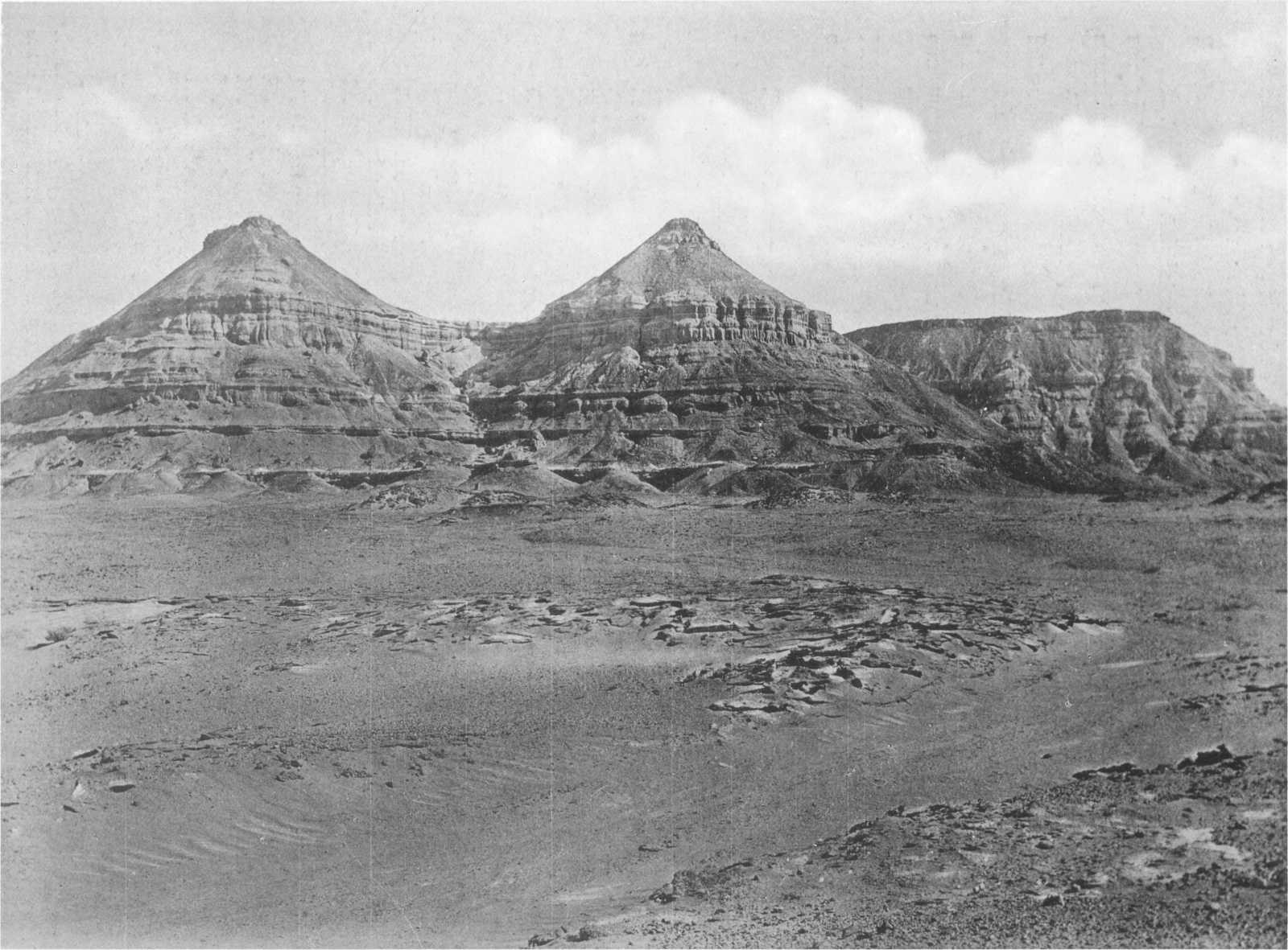
Plate X. EL QATRANI RANGE FROM THE SOUTH-EAST.
A little further west, at a point 25 kilometres north of the eastern end of the Birket el Qurûn, thick beds of white coarse sandstone form the upper part of the escarpment. Below comes a bed of yellowish impure limestone and below this an interbedded sheet of basalt 21 metres thick, underlaid by more white sandstone.
The series has almost always a constant dip of two or three degrees to the north. Silicified trees are very commonly found strewn over the surface both near the base and high up in the series.
At a point about 14 kilometres north of Qasr el Sagha definite organic remains other than bone-fragments were for the first time met with in the series. Here a fragment of ochreous-coloured grit containing numerous specimens of a small Melania was picked up and similar rocks were afterwards found in situ. Calcareous grits and impure limestones occurred at the same spot, and one of the harder more compact bands of limestone was found to contain casts of Cerithium.
Also at a point 9 kilometres north of Qasr el Sagha hard grey limestones, generally compact and cherty, and sometimes semi-crystalline, are present, containing casts of Melania, frequently filled with calcite. These overlie variegated sandstones, and occur at about 40 metres below the basalt near the top of the escarpment.
Blanckenhorn has determined my fossils from these localities as follows:—
Melania nov. sp., allied to M. Nysti of the Oligocene.
Potamides scalaroides, Desh., an important guiding form of the Middle Beauchamp Sands of the Paris Basin, and thus Upper Eocene.
Potamides tristriatus, Lam., of the Parisian (Cerithium crispum, Desh.,) is nearly related to the frequent Middle and Upper Eocene C. perditum, Bay, between which, according to Cossmann, transitions exist.
Cerithium tiarella, Desh., of the Middle and Upper Eocene, but more especially in the latter.
Blanckenhorn considers these determinations as certain, and thus marking the complex as Upper Eocene, on the level of the “Beauchamp Sands” of the Paris Basin, and consequently of the Lower Headon Hill beds and Barton Clay of the South of England.
The following section was measured from the base of the series, 2½ kilometres N.N.W. of Qasr el Sagha, to the summit of the escarpments, 2 kilometres N.N.W. of Widan el Faras. The series has its maximum thickness at this point.
Summit of escarpment of Fayûm depression, 2 kilometres N.N.W. of Widan el Faras.
Top. Metres.
1. Sandstones with band of coarse dark ferruginous grit; silicified logs occur weathered-out of this bed 18
2. Coarse sandstone-grit with yellowish calcareous base 1
3. Greyish clay, possibly a product of decomposed basalt
4. Basalt sheet, soft friable, grey or bright green, and decomposed at base 5
5. Hard yellow calcareous-grit with calcite-filled cavities, passing into semi-compacted yellowish sand, hardened at junction with basalt 1
6. White and red sands 27
7. Greenish sandstones and yellow concretionary sands with 2·5 cm. layer of calcareous grit, with gastropods including large Cerithium, Melania sp., Turritella pharaonica, Pleurotoma ingens, May.-Eym., occasional lamellibranchs and also Callianassa
8. White, green and brown sands and sand-rock 17
9. Hard yellow calcareous grit 10
10. Red and white clayey sand and sandy clays; some pebbly bands; Lucina sp., Unio sp.,[67] preserved in brown ironstone, common in places on this horizon
11. Coarse grey and white sand (2 metres) 5
12. Red clayey sands (1 metre)
13. White and yellow sand and sand-rock
14. Red clays 7
15. Sandy ferruginous band with lamellibranchs and gastropods of genera Unio, Pseudodon, Mutela, Spatha and Lanistes, indicating fluviatile or fresh water conditions of deposition 5
16. Green clay (1 metre) passing into a red variety 6
17. White sandy clay (2 metres)
18. Red clays
19. White, brown, and red sands, partly consolidated
20. Bright red clay
21. Hard coarse sandstone 3
22. Hard compact light yellow limestone enclosing sand-grains (½ metre) 5
23. White and yellow sands
24. Greenish clays (1 metre)
25. Coarse white sands with Unio and Cardium-like lamellibranchs preserved in brown ironstone
26. Grey clay 2
27. Hard yellow impure limestone (forms a small platform) 2
28. Grey clays
29. Red and yellow sands with hard base of grey sandstone 15
30. Grey sandstones. Base of basalt-capped escarpment 7
(Section continued ¾ kilometre south-east).
31. Hard blue-grey compact cherty limestone (½ metre) with casts of Melania; hollows often filled with calcite 18
32. Variegated (red, white and yellow) sands, sand-rock and sandy clays 18
33. Hard compact close-grained limestone
34. Red and white variegated sands and sand-rock, with some bands of red clay
35. Hard yellow impure limestone (⅓) 14
36. Grey clays
37. Coarse white sand
38. Brown calcareous sandstones
39. Greenish and grey sandy clays (3 metres) 8
40. Alternating white and red sands
41. Coarse yellow calcareous grit (½ metre) 2
42. Light green sandstone
43. Reddish clays
44. White sand 2
45. Alternating white and bright red sands 19
46. Grey sandstone with silicified wood; occasional crocodilian and other bones
47. Hard red clays 5
48. Grey and brown clays, sandy clays, and thin beds of sandstone with some silicified wood 19
49. Grey sandstones and loose false-bedded sandy clays with many silicified trees and remains[68] of Arsinoitherium Zitteli, Bead., Palæomastodon Beadnelli, Andr., Mœritherium sp., Phiomia serridens, Andr. and Beadn., Saghatherium antiquum, Andr. and Beadn., S. minus, Andr. and Beadn., Megalohyrax eocænus, Andr., Ancodus Gorringei, Andr. and Beadn., Pterodon africanus, Andr., Crocodilus sp., Tomistoma africanum, Andr., and large and numerous tortoises (Testudo Ammon, Andr.)[69] and turtles[70], and very rarely fragmentary fish-remains 5
50. Thin bands of limestone 25
51. Yellow sand-rock
52. Grey sandstone with fragments of bone (½ metre)
53. Brown calcareous-grit (½ metre)
54. Light green sand-rock and sandstone
Approximate total thickness in metres 271
The specimens collected from Bed 15, on about the same horizon as the fossils mentioned from the locality 14 kilometres north of Qasr el Sagha, were examined by Blanckenhorn, who has published the following notice of them:—
“I should first mention the fresh-water shells found by Beadnell in brown sandstone 1 kilometre north of Camp 19 (i.e. at Widan el Faras), which, in the absence of special literature on the Palaeogene fresh-water shells of North Africa and nearer Asia, I have compared with the fauna of to-day, in which I was most kindly helped by Professor v. Martens, Director of the Conchological Collection of the Natural History Museum. The greater number of the forms have a distinctly tropical, and more especially Central African, character.
Unio sp., small, related to the recent U. Nyassænsis of Lake Nyassa.
Unio, related to U. Homsensis[71] Lea, from Syria, and U. Bonneaudi from Cochin China, with many radial folds behind the umbo which run obliquely from the blunt edge backwards towards the hinge-border.
Unio, related to U. teretiusculus, Phil. (Caillaudi, Fer., lithophagus, Ziegli.) of the Nile.
Pseudodon? sp.
Mutela (a genus of tropical Africa) sp., long, with a straight finely-toothed hinge-border which very much recalls that of Barbatia (a sub-genus of Arca).
Spatha sp. related to S. dahomeyensis and S. Droueti of Assinia in West Africa.
Lanistes carinatus,[72] scarcely distinguishable from the Nile form.
The Melania occurring in mass in the uppermost calcareous bed appears to be a new species[73] whose nearest relation must in any case be M. Nysti of the Oligocene, not M. muricata of the Eocene, amongst forms at present known.
Turritella angulata, Sow. A marine form, occurring below the basalt and indubitably this species, as it is well preserved and easily determined[74]; T. angulata ranges from the Middle Eocene to the Lower Oligocene of the East and occurs in the Upper Mokattam of Syria.”
From Widan el Faras the series continues westwards, forming several escarpments, the uppermost that of Jebel el Qatrani, and maintaining the same general characters. The tripartite character of the series, already noticeable between Qasr el Sagha and Widan el Faras (see foregoing section) becomes still more marked. The lowest division is very largely composed of fluviatile sands and sandstones, frequently coarse-grained and usually markedly current-bedded, divided by clays and containing an abundance of silicified trees and quantities of vertebrate remains. These soft beds, some 60 metres in thickness, have as a rule an extensive outcrop, forming an undulating plain averaging two or three kilometres in width. They are overlaid by some 17 metres of harder dark red sandstones, which invariably form a well-marked escarpment capped by a very constant two or three metres band of hard white or pinkish calcareous grit. This grit varies in composition, frequently passing into a marl; and one of the characteristics of this and the underlying red beds is the abundance of nodular masses of calcite and gypsum. In some localities, as for instance 3 kilometres W.N.W. of Qasr el Sagha, numerous spherical nodules of beekitic chalcedony occur in the beds of this division, and some of these when broken are found to be geodes lined with beautiful crystals of quartz and calcite.
The next division consists of some 60 metres of alternating sandstones and clays with occasional thin calcareous bands in the upper part, and capped by a well-marked hard cherty limestone, frequently passing into a dense tabular chert or flint. This exceptionally hard band generally forms a dip-slope plain of some width, before the softer basal members of the third and highest division overlie it. The siliceous bed caps many of the most notable hills in the district; among others may be mentioned the big isolated hill 9 kilometres north-west of Garat el Esh, and the hills five kilometres N.N.E. of the same point. This is the only horizon throughout the Eocene succession of the Fayûm on which an abundance of flint is met with; that it was well known and exploited in early times is evident from the old pits met with on the summits of the hills overlooking the main bone-pits, a few kilometres north of Garat el Esh. As no worked flints were noticed round the workings it is probable that the material was excavated and carried away to the borders of the lake, there to be fashioned into the harpoons, saws and other implements which are so commonly found scattered at the present day near the margin of the old lake site.
The uppermost division of the Fluvio-marine series consists of over 100 metres of variegated sediments and forms the escarpment of Jebel el Qatrani itself, capped by the conspicuous band of hard black basalt, which is itself overlain by a further 20 metres of similar sediments. The basalt has a thickness of over 20 metres in places, though its average is considerably less; at the base it is frequently decomposed, soft, and of a brown colour.
At a point due north of the western end of the Birket el Qurûn the interbedded basalt sheet terminates, and no further flows were seen as far as the point up to which the series was mapped, nearly due north of Gar el Gehannem. As far as could be seen on a traverse through the Zeuglodon Valley to the south-western limits of the depression no further basalt flows occur.
Section from the base of the Fluvio-marine series, 2 kilometres north of Garat el Esh, to the summit of Jebel el Qatrani 5½ kilometres north of the bone-pits. (See Plates XVIII and XXIV).
Summit of plateau. Approximate thickness in metres
1. Coarse sandstones and grits 13
2. Basalt 25
3. Yellow sands and sandstones, capped by 3 m. of hard concretionary grey sandstone with occasional mammalian bones (underlying basalt in scarp and capping outlying hill) 15
4. Hard sandstones with clayey bands 8
5. Sandy and clayey beds 5
6. Hard yellow calcareous grit 5
7. Clays and clayey marls 7
8. Sandy beds 15
9. Hard sandstone (forms connecting ridge between hill and escarpment) ½
10. Clays with thin sandstone bands 40
11. Variable sandy and marly red clays with a hard yellowish sandstone band ten metres from base
Base of isolated hill.
12. Soft sands with chelonian and crocodilian remains 4
13. Sandy clays with chelonian and mammalian (Arsinoitherium) bones, capped by coarse grit, in part ferruginous silicified grit and quartzite 1
14. White calcareous grit and marly limestone. Band of flint in places
Summit of hill overlooking bone-pits.
14. Sandstone, becoming calcareous and passing up into 3 m. of hard white calcareous grit, and yellowish white bedded marly limestone with calcite druses. Capped by ¼ m. hard tabular chert and flint 10
15. Finely laminated grey shaly clays, sandy and marly clays, capped by 2 m. of mottled yellow and red sandstone and sandstone-grit 10
16. Hard red, green, and brown sandstone
17. Variegated grey, green and red clays, marly clays and sandy beds, with thin bands of sandstone. More arenaceous towards top 21
18. Hard grey sandstone; greenish sandy clays; hard dark red marls and marly clays at top 6
19. Thin band of hard yellow limestone, capping salty red clays and sandy clays 6
20. Soft greenish clayey sandstone capped by ½ m. of hard false-bedded concretionary sandstone with numerous enclosed coprolites 3
Base of hill overlooking bone-pits.
21. Pink calcareous grit (forming summit of lowest escarpment), with small flint and quartz pebbles in some layers. An abundance of calcite and gypsum 3
22. Mottled red and green clayey sandstone, clays and clayey marls. Passing up into a hard sandy (or clayey) dark red marl with greenish mottlings 7
23. Light yellow finely-laminated sandrock passing up into dark red sandrock. Some clayey bands 10
24. Coarse unconsolidated false-bedded sands, with occasional bands of clay and consolidated sandstone bands. Numerous silicified trees and abundant mammalian and reptilian remains. (See list in Bed 49 of Widan el Faras section). Bone-pits are in this bed 40
25. Thin band (½ m.) of hard sandstone with sometimes impure calcareous grit 10
26. Hard light yellow sandstone, often very coarse, and with red bands
27. Soft brick red and light yellow sands and sandstones, (seen on plain and overlying uppermost limestone of the Middle Eocene) 20
Base of Fluvio-marine Series.
Plate XI. SILICIFIED TREES OF FLUVIO-MARINE SERIES, 4½ KILOMETRES NORTH OF QASR EL SAGHA.
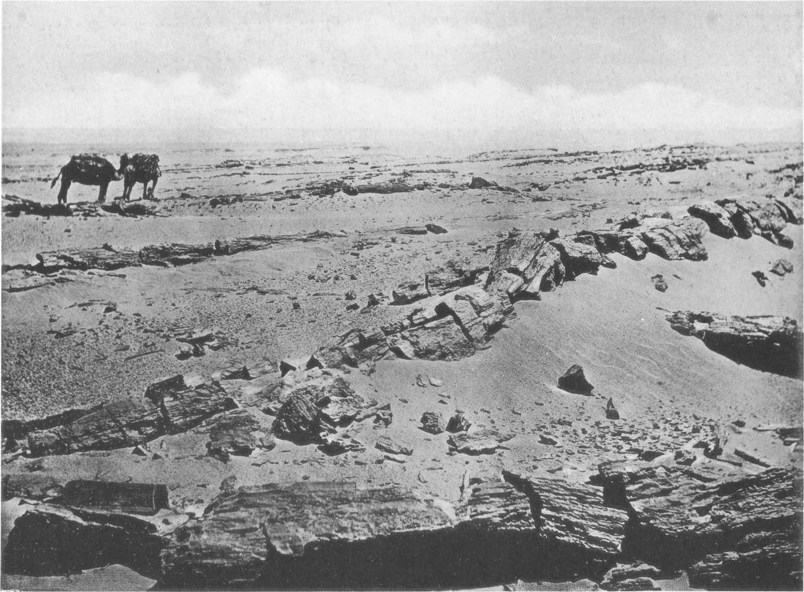
In some localities pebbly bands occur in the sandstone-grits, especially in some of the beds above the basalt: the pebbles are mostly quartz or flint, subangular or rounded, the layer averaging perhaps two cm. in diameter, although occasional specimens three or four times that size are met with. Silicified trees of two distinct types[75] occur, and they are met with chiefly on two horizons; usually large numbers of trees occur together, completely covering the surface in places; they lie as a rule scattered about in every direction, although occasionally a large proportion may show considerable parallelism of deposition, as if arranged by the direction of the current which floated them to the spot. They always occur in a horizontal position or parallel to the dip of the bed, and it seems quite certain that none of them ever grew near where they are now found. The trees never bear attached branches, the latter having always been broken off at or near the point of junction with the trunk, where the scars are often plainly seen; this points to the trees having been drifted a considerable distance. Many trees over 25 metres[76] in length have been met with, but this by no means represents the original height, as the trunks have lost considerably in length during transport to their present localities. Although, as a rule, found completely weathered-out and exposed on the surface, in numerous localities these silicified trees are to be observed firmly embedded in the sandstones in which they were deposited, many being met with in our excavations for bones.
As the Fluvio-marine series is followed westwards from the central part of the area, the different divisions become more and more attenuated and the outcrops more and more obscured by superficial gravel. North-west of the Zeuglodon Valley an escarpment capped by a conspicuous bed of white calcareous grit occurs and perhaps represents the lower beds of the series. The higher are lost on the gravelly undulating plateau above.
F.—Age of the “Fluvio-Marine Series”.
The beds in question being as a whole remarkably unfossiliferous, a determination of their exact age on palaeontological grounds is an undertaking of some difficulty. The series, however, in certain beds is very rich in vertebrate remains; a considerable number of new and important forms have already been obtained and further additions are probable. Until the survey of the area in 1898 it appears that the only fossils obtained from these rocks were a few casts and badly-preserved specimens of mollusca from the highest beds above the basalt, collected by one or two observers from localities between the summit of the Fayûm escarpments and the Pyramids of Giza.
The Rohlfs Expedition did not visit this part of Egypt, and Zittel[77] tabulated the beds, which he called the “Schichten von Birket el Qurûn” as doubtfully Oligocene; probably the beds referred to are those of the island Geziret el Qorn, which, as already mentioned, belong to the lower division of the Birket el Qurûn series, and are therefore of Middle Eocene age. Mayer-Eymar[78] states that he was able to subdivide the series under discussion into Upper and Lower Ligurian and Lower Tongrian. Schweinfurth[79] considered the series as Miocene, comparing them with the lithologically similar Scutella beds of Der el Beda to the east of Cairo. Blanckenhorn, on the evidence of the writer’s fossil collections, states, as already mentioned, that the upper part is certainly to be regarded as Lower Oligocene and the lower part as Upper Eocene.
First as to the stratigraphical position of the series. There is no doubt that the lowest beds of the group were deposited (at any rate in the central part of the area) in practical continuity with the Qasr el Sagha series, which, as shown, is certainly of Middle Eocene age. A great change in the lithology of the beds, however, makes the junction a perfectly natural one. We pass from a truly marine series into an estuarine or fluvio-marine set of beds, and such a change near the summit of the Eocene is not an uncommon one in some parts of Europe. The stratigraphical position in the field, therefore, favours an Upper Eocene age for the lower beds. The dip being northwards, newer and newer beds are met with from south to north on the great undulating, but more or less level, desert north of the escarpment summit. The occurrence of Lower Miocene beds at Mogara, some 100 kilometres north or north-west, also points to a somewhat younger, or Oligocene, age for the underlying beds, (i.e., those between the Fayûm escarpment and Mogara). The actual relations, however, of the beds in the two localities have not yet been determined, but it is probable younger beds are continually met with from south to north.
Until the entire collection of fossils has been examined and determined, it is somewhat premature to attempt to fix the age of the series on palaeontological grounds. Up to the present the foregoing lists show the species which have been provisionally or finally determined. Some of these appear to be identical with species which have been recorded from Upper Eocene deposits of Europe, such as Potamides scalaroides, P. tiarella, while others, such as Melania cf. Nysti, Natica crassatina (found below the basalt in the so-called Sandberger Hills north-east of the Fayûm escarpment), are typically Lower Oligocene. Other forms, such as Turritella angulata, are common to both Eocene and Oligocene elsewhere.
If Blanckenhorn’s determinations of these forms are confirmed, we may regard the upper beds, i.e., those immediately above the basalt, as undoubtedly of Lower Oligocene age. The beds below the basalt mark the transition from the Eocene to Oligocene, while the base of the series, so far unfossiliferous as far as molluscan remains are concerned, must be regarded as of Upper Eocene (Bartonian) age.
We may hope that when the important vertebrate fauna occurring chiefly in the basal part of the series has been thoroughly exploited, and the remains systematically determined, confirmatory evidence will be obtained. At present the only forms described and determined, beyond pointing to a pre-Miocene age, do not indicate any definite horizon. Probably most of the animals will prove to be new, and although on that account more interesting from one point of view, will probably not assist us greatly in the exact determination of the age of the beds in question.
G.—The Position of the Land-mass from which the Mammal Remains were Derived.
The existence of remains of land animals throughout the larger part of the Qasr el Sagha series and in still greater quantity in the basal beds of the overlying Fluvio-marine series, and occasionally in the highest beds also, points to the presence of continental land within no great distance of the area in which these deposits were laid down. That the animal-remains were carried out from the land by river currents is almost certain, and although in some cases such currents are known to persist to great distances from their points of emergence, it seems probable from the quantity and mode of distribution that the Fayûm bones were deposited within a moderate distance of land. Moreover, the silicified trees, by which the bones are so often accompanied, occur together in very great quantities, and we should imagine that the individual trees would have been far more scattered if they had been floated to considerable distances from land. On the other hand the fact that among the hundreds of trees examined, in no single case were branches found attached to the trunk, points to the conclusion that these trees had travelled great distances; probably the branches were lost during their river journey, from constant jamming together of a great number in a more or less constricted space, and not after they had left the river mouth.
The exact position of this land-mass is a highly interesting and important question. There is no reason to suppose that land of any extent occurred to the north, except possibly an occasional island, such as that of the Cretaceous massif of Abu Roash,[80] west of Cairo, which probably formed an island in the sea at that time; without doubt the great Eocene sea which covered the area stretched northwards, and was continuous with that in which the southern European deposits of this period were laid down. To the west also there was certainly no land-mass within approximate distances. Eastwards, possibly part of the Red Sea Hills igneous range may have formed a restricted land-area, but even this is not probable; in fact, it seems certain that we must look to the south for the nearest land of any extent. In supposing the land lay in this direction we are confronted at the outset with the fact that the Lower Eocene limestones stretch southwards for several hundred kilometres. In Egypt the Lower Eocene consists of a great mass of nummulitic limestones, some 400-500 metres thick, with no intercalated clays or sandstones except at the base, and was evidently formed in water of considerable depth. The thickness of, and superficial area covered by, these limestones show that they were formed in a truly open sea, in contra-distinction to a littoral area; the nummulitic sea in fact covered an enormous part of Europe, North Africa and Asia. To the south of this sea lay the African continent, a land-mass dating possibly from Palæozoic times. Since, and possibly partly during, the deposition of the Lower and Middle Eocene formations, a gradual elevation of the land or lowering of the sea, resulting in a retreat of the latter, took place; this continually brought the shore-line further northwards until, during the deposition of the beds of the Qasr el Sagha series of the Middle Eocene, we may surmise that it was not very far to the south, though the exact distance is extremely doubtful; while in Upper Eocene times it was still further north. We may assume therefore that the Upper Eocene bone-bearing strata of the Fayûm represent sediments transported by rivers and currents from a fairly adjacent continental land-mass to the south and laid down as littoral and delta deposits beyond the margin of the land. That at least one large river emerged from the land in the neighbourhood of the Fayûm is certain; drainage was then, as now, from south to north, although not probably confined to a single channel like the present Nile.
Apart from broader considerations a minute examination of the more typically fluviatile beds favours the conclusion that the currents were from the south or south-west. The general dip of the strata, probably the natural inclination of the sediments at the time of deposit, is from south to north; the most frequent lamination in the current-bedded arenaceous deposits is also from south to north. In our excavations for fossil bones it was noted that of seven tortoise shells exposed at the same time in different parts of the pit, six lay with their long axes similarly orientated and were distinctly tilted to the north-east, or exactly away from the point of the compass from which, as will presently be shown, the main river probably came. As a rule, however, the scattered fossil bones and trees in these beds give no definite clue as to the direction from which they were floated. The existence of separate accumulations of fluviatile sand at different horizons, but lying one above the other in the series and along a north and south line, is of importance as indicating the continued appearance of a river current from the same quarter.
Blanckenhorn has published[81] diagrams showing what he supposes to have been the relative areas occupied by land and sea in Upper Mokattam, Lower Oligocene, Middle Pliocene and Pleistocene times. Various lines of drainage are shown, the main river, which he calls the Ur-Nil, being placed some 70 kilometres to the west of the modern Nile, although closely following the trend of the latter. We have been unable to ascertain on what evidence Blanckenhorn relies for assuming rivers in Upper Mokattam and Lower Oligocene times to have occupied the positions shown on his diagrams; the number and positions of such rivers must remain more or less problematical. In this connection however it is interesting to recall[82] the lacustrine ferruginous grits which were brought to notice by the writer in 1900 as having been deposited in a lake, occupying in post-Middle Eocene times a shallow depression in that part of the Libyan desert now occupied by the oasis-depression of Baharia. Similar deposits were found forming the hills of Gar el Hamra a few kilometres east of the extreme north end of the depression. Finally, during a traverse through the unexplored country south-west of Gar el Gehannem in the winter of 1902-1903, hills capped with dark hard ferruginous silicified grits and puddingstone were met with in the extreme south-west of the Fayûm depression at a point nearly midway, and in the direct line, between the hills of Gar el Hamra and the chief bone-bearing localities in the north of the Fayûm. The deposits in question—at Baharia, at Gar el Hamra and in the hills to the south-west of the Fayûm—are evidently of lacustrine and fluviatile origin; and we may infer, with some degree of probability, that they were laid down along the course of a river which flowed in a north-easterly direction and formed extensive delta deposits in what is now the northern part of the Fayûm. That this river had its origin in the interior of a well-wooded continent hundreds of miles to the south of Baharia is not to be questioned; its size, length and exact position must remain matters of doubt, but of its existence we can be as certain as if in times of flood we had stood on its banks and watched the passage northwards of its turbid swollen waters, laden with matted rafts of forest trees and bearing seawards the carcases of those curious Eocene animals, the remains of which are so abundant in the Fayûm of to-day.
Fig. 6.—Probable Course of chief river of Upper Eocene and Oligocene times.
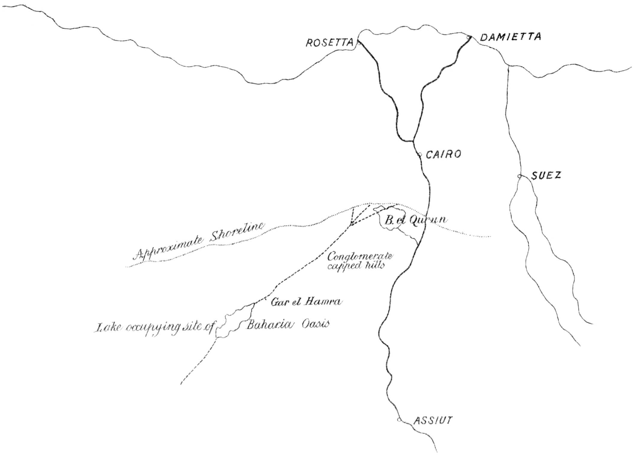
In the Middle and Upper Eocene beds we first obtain an idea of the animals which inhabited Africa in Tertiary times, and the collecting and working out of this fauna will throw much light, not only on our actual knowledge of the African vertebrata of the Eocene period, which was practically nil until the discovery of the remains here described, but also on other wider biological questions, such as the origin of certain groups of animals, some of which were evolved in this part of the world.
As recently pointed out by a writer in the Field (No. 2605, Nov. 29, 1902) many years ago the late Prof. Huxley, to account for the present distribution of the mammalian fauna of Africa and Magadascar, advanced the theory that in the early part of the Tertiary period Madagascar was connected with Africa, and Africa with Europe or Asia, a connection which allowed of the immigration into Africa and Madagascar of numerous small types of European and Asian mammals. Madagascar later becoming separated from the mainland, its fauna, undisturbed by the larger carnivora, was able to develop to its present remarkable extent. Subsequently to the isolation of Madagascar the ancestors of the modern fauna were presumed to have invaded the African continent from the north.
The extinct fauna of the Fayûm, however, shows that in early Tertiary times Africa already had its own mammalian fauna, which, besides containing some remarkable large types of somewhat doubtful position, such as Arsinoitherium, Barytherium, etc., certainly in Mœritherium and Palæomastodon included the earliest known elephants, the forbears of the Mastodon and the modern elephants. There is little doubt therefore that in Upper Eocene and Oligocene times these early members of the elephant group ranged northward and eastwards into Asia and India, and since in the Upper Tertiary deposits of India and eastern Asia the extinct transitional types between the mastodons and modern elephants appear to have been found, it is not unlikely that during the later phases of the evolution of this group of animals the radiation was back towards Africa, so that the African elephant may be, as it has usually been regarded, an immigrant from the Oriental region. Further research among the later deposits of the Fayûm and the deserts to the north may, however, throw an entirely new light on the subject and it is somewhat premature to theorise at present.
Plate XII. RAISED BEACH UNCONFORMABLY OVERLYING MIDDLE EOCENE LIMESTONES (BIRKET EL QURUN SERIES) IN THE DESERT EAST OF SIRSENA.
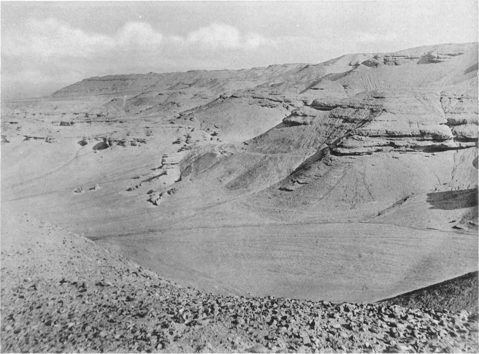
In this connection it is interesting to notice the observation of so eminent a palæontologist as Prof. H. F. Osborn. In two recent addresses[83] to the New York Academy of Sciences he pertinently points out his belief that the African continent has been a great centre of radiation of certain groups of the mammalia, and especially mentions the Proboscidea as likely to have been evolved in the Ethiopian region. Our discoveries in the Fayûm and Andrews’s determinations, made subsequently to these addresses, so completely confirm this view, at any rate with regard to the elephants, that it may not be out of place to give here a somewhat lengthy extract of his “Theory of Successive Invasions of an African Fauna into Europe” (op. cit. pp. 56-58). “In Europe there are in the Upper Eocene two classes of animals, first those which have their ancestors in the older rocks; second, the class including certain highly specialized animals which have no ancestors in the older rocks, among these, perhaps, are the peculiar flying rodents or Anomaluridæ, now confined to Africa, and secondly the highly specialized even-toed ruminant types the anoplotheres, xiphodonts and others, the discovery of which in the gypse near Paris Cuvier has made famous. It is tempting to imagine that these animals did not evolve in Europe but that they represent what may be called the first invasion of Europe by African types from the Ethiopian region.
“It is a curious fact that the African continent as a great theater of adaptive radiation of Mammalia has not been sufficiently considered. It is true that it is the dark continent of palæontology for it has no fossil mammal history; but it by no means follows that the Mammalia did not enjoy there an extensive evolution.[84]
“Although it is quite probable that this idea has been advanced before, most writers speak mainly or exclusively of the invasion of Africa by European types. Blanford and Allen, it is true, have especially dwelt upon the likeness of the Oriental and Ethiopian fauna, but not in connection with its antecedent cause. This cause I believe to have been mainly an invasion from south to north, correlated with the northern extension of Ethiopian climate and flora during the Middle Tertiary. It is in a less measure due to a migration from north to south. Let us therefore clearly set forth the hypothesis of the Ethiopian region or South Africa as a great center of independent evolution and as the source of successive northward migrations of animals, some of which ultimately reached even the extremity of South America, I refer to the Mastodons. This hypothesis is clearly implied if not stated by Blanford in 1876 in his paper upon the African element in the fauna of India.
“The first of these migrations we may suppose brought in certain highly specialized ruminants of the Upper Eocene, the anomalures or peculiar flying rodents of Africa; with this invasion may have come the pangolins and ard varks, and possibly certain armadillos, Dasypodidæ, if M. Filhol’s identification of Necrodasypus is correct. A second invasion of great distinctness may be that which marks the beginning of the Miocene when the mastodons and dinotheres first appear in Europe, also the earliest of the antelopes. A third invasion may be represented in the base of the Pliocene by the increasing number of antelopes, the great giraffes of the Ægean plateau and in the upper Pliocene by the hippopotami. With these forms came the rhinoceroses with no incisor or cutting teeth, similar to the smaller African rhinoceros, R. bicornis. Another recently discovered African immigrant upon the Island of Samos in the Ægean plateau is Pliohyrax or Leptodon, a very large member of the Hyracoidea, probably aquatic in its habits, indicating that this order enjoyed an extensive adaptive radiation in Tertiary times.