VI THE SEPARATE DISTRICTS OF THE PYRENEES (continued 2)
Reading edition
I should mention before I leave this district that curious plain, Des Etangs “Of the Lakes,” where is the Trou du Toro, a small circular pond.
The main source of the Garonne lies high up as befits the dignity of such a river in among the very noblest peaks of the Pyrenees; it springs from the eastern point of the Maladetta, flows down in a torrent to this plain “Of the Lakes,” plunges into the little pond, and there wholly disappears! It reappears 2000 feet down at the Goueil de Jeou, on the northern side of the mountains, having burrowed right under the main range, and so runs down to Las Bordas. Sceptics to whom all in these bewitched mountains is abhorrent, from the realities of Lourdes to the legends of Charlemagne, annoyed by this miraculous action on the part of the Garonne, poured heavy dyes into the Trou du Toro, and then went and watched anxiously at Goueil de Jeou to see the coloured stream emerge; but the Garonne was too dignified to oblige them, and the water came out limpid and pure; as for the dye, it has stuck somewhere underground in the hills, and is colouring rocks that will never be seen until the consummation of all things at the end of the world.
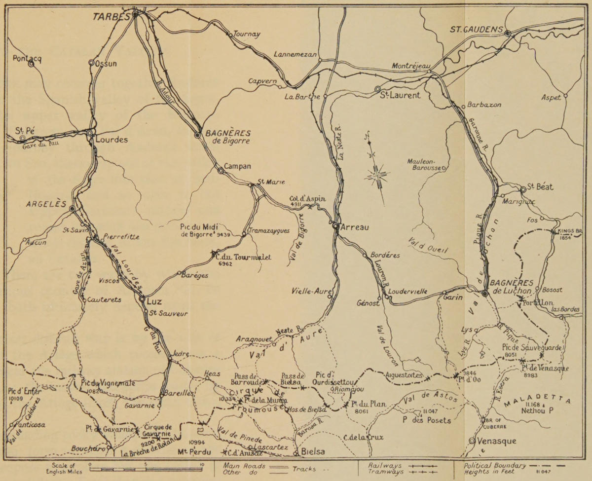
THE TARBES VALLEYS & LUCHON
V. Andorra and the Catalan Valleys
One may consider together Andorra in the Spanish valley of the Segre, the upper valley of the Noguera Pallaresa and Val d’Aran, for the journey through Andorra down to Seo, thence up out of the valley of the Segre into that of the Noguera, and so over to the Upper Garonne, makes one round, in which one covers one whole district of the Pyrenees, all Catalan.
There are two ways by which the curious country of Andorra can be reached from the north; both ultimately depend upon the valley of the Ariège.
The first shortest and most difficult way is by the vale of the Aston, a tributary of the Ariège which comes down a lateral valley and falls in near the railway station of Cabanes as the line from Foix to Ax; the second and easier way is by climbing to the sources of the Ariège itself, the main river, and over the Embalire.
As to the first—all the spreading rocky valleys which combine to feed the river Aston, form together a district of the very best for those who propose to explore but one corner of the Pyrenees during a short holiday. Even if such a traveller be unable or do not choose to force one of the entries into Andorra, he will have found on the Aston a country in which a man may camp and fish and climb anywhere, with a sense of liberty quite unknown in this kingdom. Here are half a dozen or more little lakes, deep forests, occasional cabanes, good shelter, good bits of rock for such as like the risk, and outlines and distances of the most astonishing kind, and no landlords. Of the many high valleys I have seen in the world, there is none less earthly than the last high reaches of the torrent which runs between the Pic de la Cabillere and the Pic de la Coumette, and which is the chief source of the Aston. The whole basin of this river includes six main streams, and, of course, many smaller torrents feeding these and the names of the peaks alone discover their desertion and the mixture of fear and attraction which they have had for the shepherds of these highland places. You may spend a week or a month or a whole summer in the neighbourhood and never come on this enchanted pocket which is bounded on the frontier by the high ridge running from the “silver fountain,” the Fontargente, with its high peak and chain of lakes.
The Aston has at its sources, cutting them off from Spain, a ridge of 8000 to 9000 feet, it is a ridge the passes of which are but slight notches between the higher rocks.
The ways into Andorra across this ridge from the Upper Aston are as numerous as these notches are, and nearly every notch can be climbed with knowledge and patience, but the only parts where something of a track exists are the Fontargente on the east, and the Peyregrils on the west. It is easy enough to fail at either, and there is therefore merit and sport enough in succeeding at either.
For the Peyregrils you must start from Cabanes and follow up the main stream of the Aston, by a clear path through the forest, taking with you the 1/100,000 map as a guide. A little after a point where a bridge is thrown over the river (called the Bridge of Coidenes), the two main streams of the Aston meet, one is seen flowing down from the south-east by the wooded gorge before one as one climbs, the other comes in cascades down a steep gully, pointing directly north and south. It is this gully which must be taken for the Peyregrils. One goes up over a steep rock still in the thick of the wood. On the far side of it one comes out into open grass country, and has one’s first sight of the main range. The path comes down again to the stream, having turned the cascade, crosses the stream and flows along its right or eastern bank between the water and a range of cliffs which are those of the Pic du Col de Gas. About a mile from this crossing of the stream, as one goes on southward with a little west in one’s direction, one comes to a side torrent falling in from the left; the path crosses this torrent, and still continues up the right bank of the main stream. It is a difficult point—for the path appears to bifurcate, and by taking the left-hand branch, as I did four years ago, one may lose oneself in the empty valley under the Cabillere and be cut off for two days as I was, or for ever, as I was not. It is by making these easy mistakes that men do get cut off, and you may be certain that people who are found dead in the mountains under small precipices, are not, as the newspapers say, killed by some accident, but by exhaustion. They have wandered in a mist, or have been lost in some other fashion, until privation so weakens them that they no longer have a foothold; and in general, the great danger of mountains is not a danger of falling, but of getting cut off from men. Here, as in many other difficulties of this kind, your compass will save you; for if you find you are going more and more to the east, you are on the wrong path. The right one goes south by west along the left bank of the stream. There is a broad jasse or pasture which one traverses in all its length, one crosses another torrent coming in from a rocky gorge upon the left, the torrent and the path together turn more and more westward until one’s general direction is due west, and at last one comes up against steep cliffs which are those of the Etang Blanc.
Thence, the way is plain, for the stream receives no further affluents and there is therefore no ambiguity of direction. The path follows the stream round a corner of rock whence one can see a tarn called the Etang de Soulauet, lying immediately under the watershed, and from that tarn the traveller goes straight up for 500 yards or so over the crest, straight down the steep further side, and finds at the bottom of the valley the stream called Rialb: such is the passage called the Peyregrils.
Once one is down on the banks of the Rialb, one has but to follow the trail which runs along the bank of that stream, cross it, reach the hamlet of Serrat, and so follow the broadening water to the little town of Ordino; four miles beyond is Andorra the Old. The whole distance from the pass to Andorra is somewhat over 12 miles, counting all the windings of the way. On this, as on so many crossings of the Pyrenees, the difficulty is wholly on the French side, once on the Spanish the broader valleys lead one without difficulty down one’s way.
The other entry into Andorra from the valley of the Aston, that by the Fontargente, is managed thus:—
When the Aston divides just after the bridge, one takes the south-eastern fork, one crosses the bridge and finds a clear path going up the right bank of the main stream of the Aston through a wood. Four miles on this path brings one out of the wood, and for another 4 miles it goes on still following the same side of the stream in a direction which is at first east of south, and at last curls round due south. There is a bridge or two crossing to the other side, but one must not take them. One must keep close to the eastern or right bank of the Aston all the way until one comes to a place difficult to recognize, and yet the recognition of which is immediately essential to success. It is a jasse rather narrow and small, lying between a rocky ridge upon the left or east and a line of cliffs upon the right or west. Here are a few cabanes, and even if one has missed the place on first coming to it, it can be recognized from the fact, that, at the further end of this jasse, the two sources of the Aston meet in almost one straight line, making with the main stream one has been following, a shape like the letter “T.”
The path branches and takes either valley or arm of the “T”; it is that to the left or east down which one must turn—the one to the right or west leads nowhere but to the impassable cliffs and precipices of the Passade and the Cabillere. The eastern or right-hand path then must be followed in a direction just south of east for exactly 1 mile, during all of which it keeps to the north of the stream. At the end of that mile it crosses the stream, turns gradually round a high lump of rocky hill, going first south, then in a few yards south-west until it comes, at about a mile from the place where it crossed, upon the large tarn or small lake of Fontargente, “The Silver Water.” The port lies in view just above the lake not 500 yards off. Once over it, it is the same story as the Peyregrils, a trail following running water which leads one through the upper villages to Canillo, the first town, to Encamps, the second one, and so down to Andorra the Old. The distance from the main range to Andorra by this trail is 2 or 3 miles greater than by the Peyregrils.
These are the two difficult and mountain ways of making Andorra from the north.
The easier and much the commoner way is to approach it from the upper waters of the Ariège.
One takes the main road from Ax to Hospitalet up which there is a public carriage or “diligence”; it is as well to go on foot, for one will get to Hospitalet before the diligence if one starts at the dawn of a summer’s day, and it is important to get there early as there is no good sleeping place between the French side and the town of Andorra itself. At Hospitalet the main track for Andorra runs down in a few feet to the torrent of the Ariège, crosses it, and follows its left bank. It goes over the frontier which is here an artificial line, and though you are still on the French side of the range, you are politically in Andorra, upon this deserted grassy slope which forms the left bank of the Ariège.
At the second torrent which comes down this slope into the river—or rather the second stream, for they are quite small—the telegraph wire, which has hitherto followed the path, will be seen going over to the right, up a somewhat steep side valley. This is at a point about 4 miles from Hospitalet. You have but to follow that line if it is fine weather, and you will come right over the ridge and down on to the Spanish side of the Andorran hamlet, Saldeu. If it is misty on the heights you will almost certainly lose the line, and possibly your life as well. Nevertheless the crossing can be made even in bad weather by going somewhat further south to the point called the Port d’Embalire. To find this needs a certain care. Note with your compass the trend of the Ariège; it curves round more and more as you follow it, and when it begins to point due south (which it does after a perceptible bend) you may note a fairly plain track coming down from the opposite side of the valley: it comes down and strikes the Ariège at a spot almost exactly 2 miles from the place where the line of the telegraph left the stream. Here opposite the road turn sharp up away from the Ariège (which is now but a tiny brook) and go due west by your compass right up the mountain, which is here nothing but a steep grassy slope, and you will strike the Embalire.
It is one of the few crossings which can be made in any weather, because you will find upon that slope, a little way up, the beginnings of a made road; that road was never completed. It has never been metalled, but it is culverted and graded, and is as good a guide as the best highway in the Pyrenees could be. Probably it never will be finished, for the Andorrans are opposed to an easy entry into their country; but so long as its platform remains, one can never lose one’s way upon the Port d’Embalire. The further side is a steep and easy descent over a sort of down, and one finds Saldeu by this longer route about 4 miles from the summit. Whether one has followed the telegraph line or come over by the Embalire, the two tracks join at Saldeu, and the rest of the way is identical with that which you will come to by Fontargente, that is, through Canillo and Encamps to Andorra the Old.
Easy as the way is, however, it should be remembered that it is a long day from Ax, for counting every turning, it is not far short of 30 miles, and more than half of that is uphill. Ax stands at about 2000 to 2400 feet (according to the part of the steep town one measures from) and the summit of the Embalire is almost exactly 8000 feet. There is no break in the rise from one to the other.
The interest of Andorra lies in its survival, and the recognition it receives of being an Independent European State. All these enclosed valleys of the Pyrenees led a more or less independent life for centuries; from a decline of the Roman power until the union of Aragon and Castille on the Spanish side, and on the French side in some places, up to the Revolution itself, they boasted their own customs and could plead their own law.
The violent quarrel between Madrid and Aragon, in which the independence of Aragon was fiercely destroyed, affected the greater part of the Spanish valleys, and killed their independence; but it did not attack the Catalan valleys—of which Andorra was the most secluded and remote, and therefore Andorra survives.
One may study in Andorra what all these valleys were in the long period of local and natural growths between the very slow death of the Roman bureaucracy, and the rapid rise of the modern. The French, through the Prefect of the Ariège (as representing the Crown of France, which in its turn inherited from the county of Foix) claim a partial control over the Andorrans who pay to the Government in Paris £40 a year in fealty. The Spaniards have a hold on it through the Bishop of Urgel, who is not only their Ordinary but also their Civil Suzerain: he gets only £18 a year from the embattled farmers.
The Andorrans have all the vices and virtues of democracy clearly apparent. They are very well-to-do, a little hard, avaricious, courteous, fond of smuggling, and jealous of interference. Also in Andorra itself one great shop supplies their external needs, and conducts all their international exchanges. Catalan, a provincial dialect in Spain, is here the national language. They are divided, as are all Catholics, into Clericals and Anti-Clericals, the Clericals making, I believe, a working majority, and there is not among them, so far as one can see, a poor man or an oppressed one.
From Andorra the Old, a good open path leads through the narrow gates of the country, down on to the valley of the Segre, and so to Seo de Urgel.
Though it is but a few hours’ walk from Andorra to Urgel, it is as well to pass the remainder of the day and the night at Urgel, especially if it is the first Spanish town you have seen, as it is the first for many people who cross the mountains at this place. You will certainly find nothing more Spanish along the whole range. This lump of a town with its narrow oriental streets was the pivot of the Christian advance into Catalonia. The Carolingian armies came pouring through that easiest of the passes, the Cerdagne, enfranchised Urgel, first of all the Mozarabic Bishoprics, and may be said to have refounded its Christian existence. For some reason difficult to discover Urgel fossilized quite early in the Middle Ages. No line of travel, no road linked up the long valley of the Segre, the armies and the embassies of the French knew nothing of Lerida, and it is characteristic of Urgel to-day that even to-day there should be no great road beyond it up the valley.
From Urgel your road back into France through the upper valley of the Noguera Pallaresa, and the Val d’Aran is difficult to discover in its earlier part, unmistakable in the high mountains; which is the reverse of the rule usual in other crossings of the hills.
You must go down the high road which runs south of Urgel until you come, in something over a mile, to Ciudad, which is that hill-pile of white houses, once fortified, which rises over against the Cathedral city.
There you must ask the way to Castellbo, which is two or three hours away up a torrent bed, and you must go up this torrent bed by way of a road.
If you start early from Urgel you will be at Castellbo well before noon, and the hospitality of the place is so great that you will wish to stay there. There is only one drawback to eating at Castellbo which is that you have after it to make a passage of the mountains which, though here not very high, well wooded and fairly inhabitated, do not bring you to proper food and shelter until you have gone close on 20 miles and have reached Llavorsi in the further valley of the Noguera; and so, if you stop to eat your mid-day meal at Castellbo, it is quite on the cards that you will have to camp out in the hills and that you will not make Llavorsi until noon of the following day; for the col in between, though it is very easy, is higher above the sea than the Somport.
From Castellbo you have but to ask for the village of St. Croz, which is perched upon a height just up the same valley, but from there to the port the way is difficult to find for the very reason that there are no physical difficulties. It is all one long ridge of wooded grass like a down, with rather higher peaks to the right and to the left and with more than one indication of a path several directions. A good rule, however, for finding the exact place where you should cross, is to make for a spot due north-west from the village of St. Croz, and this spot is further distinguished by the fact that it is on the whole lowest upon the whole saddle. It is a mile and a quarter or a mile and a half from the village, and as you go to it over the easy grass you get a superb vision of the Sierra del Cadi barring your view of Catalonia and standing up against you much higher than ever it seemed from the floor of the Cerdagne. No hills in Europe look so marvellously high.
As the saddle of this port, which is called the port of St. John, is so long and easy it might seem indifferent at what point one crossed it; it is on the contrary very important to get the exact place and for this reason, that on the further or north-western side of it there is a profound ravine densely wooded, if one does not make the exact spot one has no path through this wood. That means hours of delay and one may very well come out upon the right instead of the left bank of the ravine; in which case in order to find the trail for Llavorsi at the bottom of the valley one may have a precipitous descent into the ravine and a bad climb out of it on the other side. Look, therefore, carefully for the path which begins to be clearly marked the moment the saddle is crossed, and follow down it until you come to a steep rock which overhangs the main stream at the bottom of the valley. This main stream is the Magdalena and runs not quite 2000 feet below the summit of the port. The trail is very distinct when once one has reached the valley; small villages are passed; it climbs up on the left bank to avoid a precipitous place and comes down to the water again at a place where the Magdalena falls into the main stream of the Noguera.
Here you must descend to the floor of the valley and take the road which is being made and which will in a few years form another great international highway up the valley of the Noguera. The road runs all the way on the left or eastern bank of the stream, which is broad and rapid and confined by very high steep hills upon either side. Three miles from the place where the path descended to the junction of the Magdalena and the Noguera, you will find another large river coming in. The road crosses by a wooden cantilever bridge where one pays a toll (I think of ½d.), and once across one is in the unpleasing village of Llavorsi.
The valley opens somewhat and is called Anéu, having on the left the exceedingly rugged and tangled chain of the Encantados, a wilderness of rocky peaks and lakes—and on the right a clear ridge which cuts off this country-side from the Val Cardos and the Val Farreira, both wild districts at whose summits is a bit of country as lonely as the Upper Aston.
All the way from Llavorsi up this Anéu valley the new road runs. I have not visited it for four years, and by this time it must be nearly finished, at any rate it is perfectly straight going and in all between 10 and 12 miles, with the exceedingly filthy village of Escaló about half-way.
It is not easy to give advice about sleeping in this walk from Urgel to Esterri. The distance between the two towns in a straight line is less than thirty miles, but the perpetual turning of the path makes it quite forty by the time one has reached Esterri, and what with the casting about for the right crossing on the port and the height of that crossing, it is too much for anyone to try and do in one day. Even if one were to sleep at Castellbo it would not mend matters much, for Castellbo is but a sixth of the distance, if that, and I would not recommend sleeping at Llavorsi. I have said that if one ate at Castellbo in the morning, it would mean camping out in the woods below the port of St. John and this is perhaps the best plan after all: to leave Urgel on the morning of one day, to camp in the deep woods above the Magdalena and to sleep at Esterri, on the night of the second day. There is a good inn at Esterri, where everything is comfortable and clean, and the whole place is more civilized than any other town or village in the Pallars.
The next day you will go over the Pass of Bonaigo into the Val d’Aran, unless you prefer the much less amusing walk by the new road up over the Port de Salau to St. Girons. It is less amusing because it gets you into France almost at once, whereas the walk into the Val d’Aran keeps you in Spain and shows you a very interesting geographical and political accident of the Pyrenees.
The town of the Val d’Aran is called Viella, and it lies 20 miles west by north of Esterri, between the two there is no obstacle but a high grassy saddle called the Port of Bonaigo the summit of which is exactly 3283 feet above the floor of the Noguera at Esterri, and the interest of which lies in this, that it stands right upon the junction of that “fault” which was mentioned in the first division of this book.
The Bonaigo is the exact centre of the Pyrenean system. On your left as you cross it, to the south that is, is the Saburedo, which is the last peak of the western branch. To your right upon the north the hills lift up to the Pic de l’Homme, which is the terminal peak of the eastern branch, and the ridge uniting these two branches runs in a serpentine fashion north and south with the saddle of the Bonaigo for its lowest point.
You will reach the summit, going easy from Esterri, in about three hours, and thence you will see, if the weather is clear, the distant snow of the Maladetta to the west, and in the vale at your feet, the first trickling of the Garonne. For by the twist the watershed here takes, you are crossing geographically from Spain into France, though the valley of the Garonne before you is still politically Spanish. The descent upon the Val d’Aran is somewhat steeper than the ascent from the Noguera, a path of sorts begins at the foot of it, and runs down the Garonne to the first hamlet, the name of which is Salardú. At Arties, a road begins, and 5 miles further on you come to Viella and to rest.
In Viella there is nothing but oddity to note: the oddity of a French valley governed by Spain. You are quite cut off, you will hear no news, and the only sign that you are on the north of the mountains will be the great and excellently engineered road leading down the Garonne from gorge to gorge and reaching at last the French frontier at a narrow gate where is the “King’s Bridge.” Some miles further on is the French railway-head at Marignac. An omnibus starts in the early morning from Viella at whatever hour it pleases and gets down to the French railway in time for the mid-day train, but whether you take it or walk down on foot, you had better stop at Bosost, not half-way down, and there take the whittle woodland road westward over the frontier by a very low gap called the Portillon and so saunter into Bagnères de Luchon, the noisy and wealthy capital of luxury. To come into Luchon suddenly after such a journey is as sharp a change as you can experience perhaps in all Europe. Do not forget before you reach Bosost to look up the gully which comes in from the left at a place called Las Bordas, some six or seven miles from Viella. This gully is that of the true Garonne, the fork of the river which we saw having such strange adventures rising on the wrong side of the main watershed of the mountains, burrowing right through them in a tunnel and coming out upon the northern side; surely the only river in the world which behaves in such a fashion.
The walk which I have just described will have shown you most thoroughly all the wild north-western corner of Catalonia, and have taught you Andorra as well. Whether you take Cabanes for your starting place, entering Andorra by the difficult passes of the Aston, or whether you take Ax for your starting place and enter by the easy pass of Embalire, you will not make the whole round to Luchon in the best weather under six days, and indeed a man who has but a week in which to begin to learn the Pyrenees, might very well choose this little square of them for his first introduction.
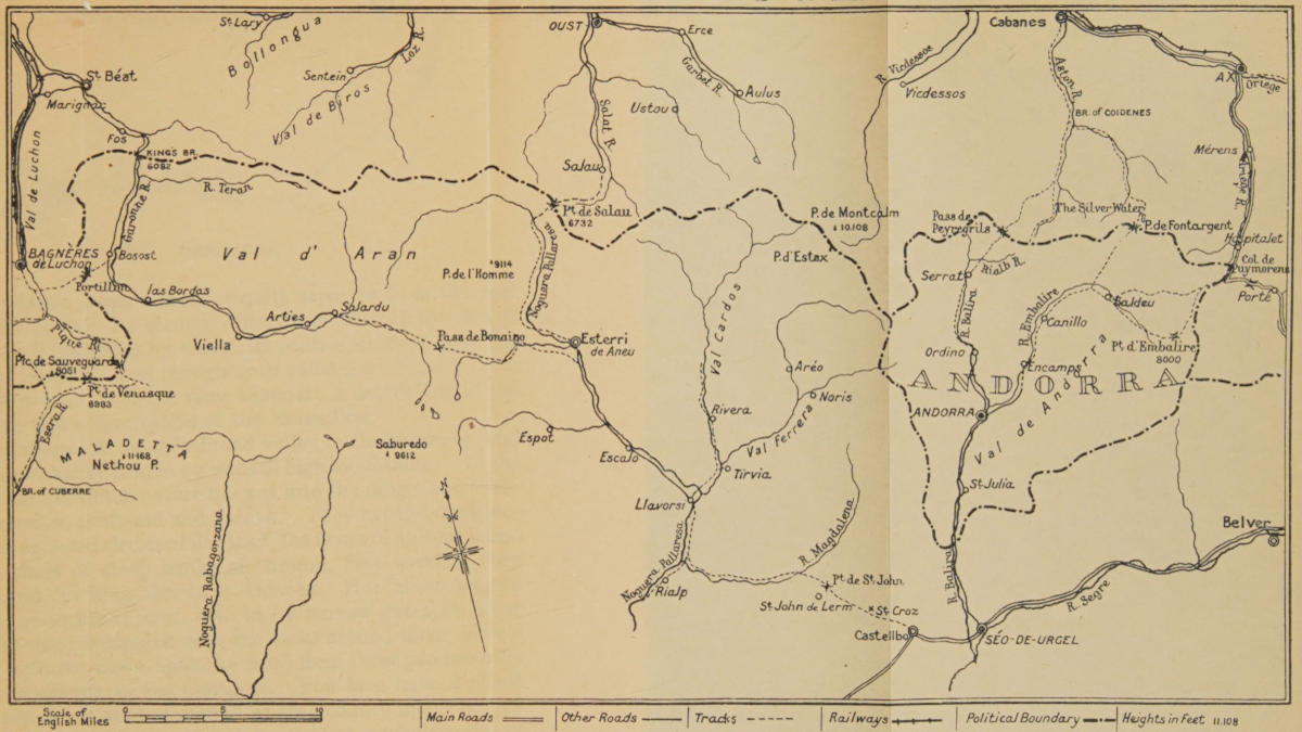
THE CATALAN VALLEYS & ANDORRA
VI. Cerdagne
The Cerdagne forms a district quite separate from the rest of the Pyrenees. Its scenery differs from that of the rest of the range, its facilities for travel, its politics, everything in the place is different; and though both valleys are Catalan, it is well not to include in the same summary a description of the Cerdagne and a description of the Roussillon.
The Cerdagne is the only broad valley in the Pyrenees, and it is a broad valley held in by walls of high mountains. All the other trenches which nature has cut into the range, are, without exception, profound and narrow. They expand occasionally into enclosed circles of flat land, the floors of ancient lakes, with a circle of steep banks all around, first wooded, then rocky, and reaching almost to Heaven. But these solemn circuses of secluded land, held in by narrow gates at either end, and small compared with the rocks around them, have a totally different effect upon the mind from those produced by such a landscape as the Cerdagne. You here have a whole country-side as broad as a small English county might be, full of fields, and large enough to take abreast a whole series of market towns. This is the sort of plain, which, were it bounded by hills, rather low like our English downs, would seem a little country by itself: a place large enough to make up one of our European divisions, like the counties of England, or the minor provinces of France. A broad river valley, such as decides a score of places scattered over Western Europe, here binds many households all united historically and defines a corporate condition for a fixed community of men.
This picture is framed in two great lines of hills roughly parallel to each other, and the effect when one comes upon it out of the last of the narrow valleys, may be compared to the effect upon a child’s mind when he first sees the sea.
In order to perceive the full contrast of this exception in the Pyrenean group, it is best to approach it from the west; whether you are coming on foot over the foothills of the Carlitte groups down on to Mont Louis or Targasonne, or whether you are coming by the high road over the pass of Porté, there comes a point in your journey where, after so many gorges and narrow cliffs, the hills here suddenly cease at your feet and you see the whole sweep of the Cerdagne as broad as a field of corn; you will have seen nothing like it all your way from the first foot hills of the Basque and the shores of the Atlantic.
On the eastern side, beyond the plain, you see the long ridge which is among the highest of the Pyrenees, and which stands steeply out of the flat. It stretches, as it were, indefinitely away into Spain and was called for centuries by the Mohammedans, and still is, the Sierra del Cadi. At its feet are a group of villages and towns, Saillagouse, Odeillo, Bourg Madame, Puigcerdá (with its curious little isolated hill), Angoustrine, Palau, Osseja, Nahija, Err, and Caldegas, and that fascinating territory Llivia, which stands enclosed, making a little island of Spanish territory in the midst of French.
The structure of the Cerdagne explains its history. It is a slightly sloping shelf upon the Spanish side of the watershed, but the watershed here is not as it is everywhere else a steep ridge with rocks, it is a large imperceptible flat which, for the first few miles upon the northern side, slopes quite gently down towards the valley of the Tet, and on the south side slopes still more gently and easily away towards Spain. The Segre, the last and largest tributary of the Ebro, rises in this gentle plain in innumerable rivulets, which joins innumerable other rivulets at Llivia, and then receives the river of Val Carol, the river of Angoustrine, and the little river of Flavanara below Puigcerdá. There is in the whole extent of this plain no natural feature to form a frontier, and (as its upper waters form the only approach to the province of Roussillon) Mazarin, when the treaty of the Pyrenees submitted the Roussillon to the French Crown, claimed as a sort of right of way, the upper stretch of this wide plain.
The negotiations were not difficult, the frontier was drawn just so as to give the French Government everywhere the road down the Val Carol and up by Mont Louis to Perpignan. It was not the frontier between two civilizations or languages, the few square miles of the French Cerdagne, which is geographically Spanish, are Spanish also, Catalan Spanish, in customs, hours, architecture, and even cooking. It is Spanish in everything save the functions of government; and here you see just what differences government can and cannot make in a country-side. Government, where it exists against the will of the governed, effects nothing; but here there is no such friction, and you may compare the contented Cerdagne, which takes its orders from Paris, with the contented Cerdagne that takes them from Barcelona and Madrid. The subtle effect of the contrast is sufficiently striking; it is seen in the type of roadway, the paving of courtyards, in clocks that keep time upon one side and not upon the other, and in a certain hardness, which French assurance breeds, and which the Spanish ease avoids. It is a good plan as one enters the Cerdagne to take the by-road which leads straight across the plain from Urgel to Saillagouse. This by-road, when you have pursued it for about a mile, enters the isolated Spanish district of Llivia, and when you reach that town you find yourself in Spain, although all the villages round you in a circle are French villages. You have the Spanish delay, the Spanish tenacity, and the Spanish disorder. On coming out of it again, and immediately over the stream on the first village, the influence of the distant prefecture and of a strong hand upon the local community is apparent.
The Cerdagne has one bad drawback that, for all its beauty and wealth, its entertainment is bad. There is not, I think, one good inn in the whole of it, and at Saillagouse, where the exterior looks most promising, the people are so hard-hearted that there is no comfort to be found under their roofs. If you are thinking of food, the best place perhaps for your head-quarters is the little village of La Tour Carol. But if you are thinking of sights, your best head-quarters is the town of Puigcerdá, just beyond the Spanish frontier, 3 miles or so from Latour.
Puigcerdá is the capital of the Cerdagne, and there the people gather as to a fair. It was the capital of the Cerdagne long before the people knew or cared whether they were governed from the north or from the south. One and a half miles away, over the river in French territory, the tiny hamlet of Hix marks the place where the old capital was before Puigcerdá was founded and ousted it in the early Middle Ages. From many points in Puigcerdá, from the terrace in front of the Town Hall, from the northern end of one of its streets, but especially from its church tower, you take in one view the whole of the Cerdagne. As one gazes upon that view, one should remember that this was the principal highway of organized Christendom against the Mohammedan, and through this went Charlemagne and his son.
The Carolingian tradition is nowhere stronger, strong as it is throughout the Pyrenees, than in this fruitful plain. The very mountains perpetuate it with the name Carlitte, and the valley of Carol and the popular songs perpetuate it also. It was this broad floor, full of provisions and free from ambuscade that allowed Christendom to dominate Catalonia, and render free the country of Barcelona, first of all Spanish territory, from the weight of unchristian government. It is the Cerdagne, therefore, to which we owe the later segregation of the Catalonians from the rest of Spain, their forgetfulness of warfare, their active commercial unrest, their modern submission to Jews, their great wealth. The Cerdagne should possess a great road throughout, for it is all of one type and all of one valley. By some historical accident it is not yet (I believe) so served throughout. After Puigcerdá there is a good new road all the way to Urgel. Another from Puigcerdá turns out of the valley of the Segre and runs off south and east to Barcelona. Certainly Urgel—that town we spoke of in connexion with Andorra—every one travelling in this part should see: Seo, the “Bishopric,” the “See”; a sort of Bastion first thrown out against the Mohammedans by Charlemagne. It is more intensely Spanish perhaps than any other large town in these hills, and that because it has long been so thoroughly cut off from communication with the north. Here also you can find good hospitality. The people are kind, and local travellers are common. Urgel is, however, more easily approached from Andorra than from Puigcerdá. And upon that account I dealt with it in connexion with the little republic.
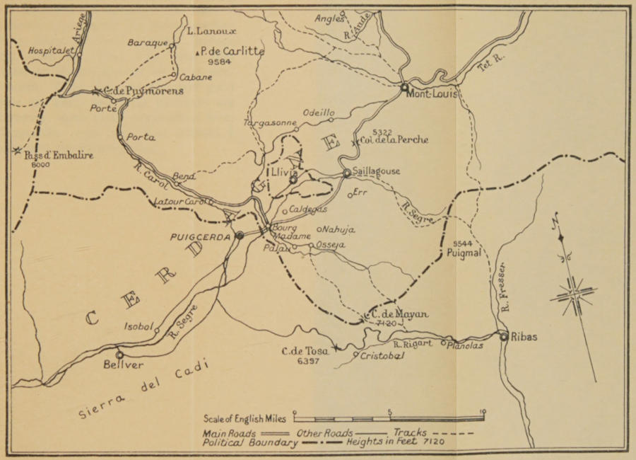
THE CERDAGNE
VII. The Tet and Ariège
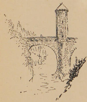
The valley of the Ariège is a basis for going either southward into Andorra by the tributary valley of the Aston or westward into Roussillon around the flanks of the Carlitte. Of the former journey I have spoken in connexion with Catalonia. The latter takes one into the valley of the Tet, and so to the Canigou which is the principal mountain of that valley. The high road up the Ariège and over the Puymorens Pass into the Cerdagne and so into the Roussillon does not concern us here. It is designed for travel upon wheels. For going on foot the district is concerned with the Carlitte and the Canigou.
If one means to spend some time in the big group of the Carlitte, one’s head-quarters must be Porté, the little village just over the Puymorens Pass. It is from here that the ascent of the highest peak is made and from here the fishermen start for the lakes that surround that peak. If, then, one proposes to spend some days camping in the mountain and going nowhere in particular, it is from Porté that one must start, as the nearest point to the summits. On the other hand, nothing can be bought at Porté nor for miles around, and if one ascends the mountain from Ax, though the distance is greater, one is more in touch with provisions.
The Carlitte group is remarkable for the number of lakes, some quite large, which are to be found in the hollows just under its highest ridges. On the north is the large Lake of Noguille with the two little tarns of Rou and Torte just above it on one side; on the other, two little tarns lie under the Pic d’Ariel. The main lake is 6000 feet above the sea, not far short of a mile long, 500 or 600 yards across, and very little visited. On the south of the highest ridge and to the east of the summit of the Carlitte, just above Porté, lies the still larger lake of Lamoux. A good mile and a half in length, but narrower than its twin upon the north. Besides these two is the little group of lakes at the source of the Tet, another group at the sources of the Ariège, and another of half a dozen and more just under the eastern cliffs of the Carlitte which feed the big marsh of the Puillouse.
Unfortunately all this district, which is so wild and open for travel, and so full of good fishing, has but few camping grounds. The forest on the east of the Carlitte is one of the largest in the Pyrenees, and one may camp anywhere within it; but for a lake as well as wood one can find but four spots: one, the Camporeils; the other, the little pond just above Langles; the third, a whole group of lakes a mile south and a little west of the marsh of Puillouse. It is by these last that one will do well to camp if one is making one’s way over the mountain eastward to Mont Louis, for they are within 5 miles of that town, and just beyond it is the valley of the Tet. The best camping ground in the neighbourhood of Ax is the fourth spot, at the northern end of the lake of Noguille. Here the lake, the stream flowing from it, and the wood are all close together and as good a camping ground as any in these mountains can be chosen. The way to reach this is to leave Ax by the western road which branches off from the great national road and runs up the valley of the Oriège to Orgeix. Beyond this little village of Orgeix is another little village, Orleu, and beyond that again at the head of the high road and not quite 5 miles from Ax is the point where you must turn off for the lake. It is not easy to find because the whole distance is very similar for miles. I will describe the way as best I can.
After the road leaves Orleu you have upon the left very precipitous steeps, rising to a height of some 6000 feet (or more than 3000 above the dale) covered with a forest which comes down very nearly to the road. On the right is a stream, and beyond it another belt of wood, less steep, with bare and high rocks above. Somewhat over an English mile, from the Church of Orleu, a path leaves the road to the right and crosses the stream, taking its way upwards through the opposing wood; this path will lead you to the lake, but it is not the best way. The best way is to go on further, somewhat over half a mile to a group of huts called “The Forges.” Here you will see on the other side of the stream a valley running towards you from the mountain and coming from due south as you look up it. The valley, or rather ravine, is that of the torrent called Gnoles, and this is the gully you must follow. It falls into the Oriège just by the forges. You must go some yards beyond this junction of the streams and a path will be seen going right off at a right angle to the road and making for the gulley opposite. It crosses the Oriège at once, crosses the torrent almost immediately after, climbs up the steep on its left bank, crosses again on its right bank, and thence keeps on due south between the rocks and the stream, through the wood, until, at a point the height of which I cannot discover but well over 2000 feet above the road, it comes out suddenly upon the lake.
Here is the best camping ground within a reasonable distance of provisions and succour, and yet quite remote enough for a hermit. Here with the aid of the 1/100,000 map, one may wander and take one’s luck in the whole of this district of high peaks, rocks, and tarns, which stretch every way for 8 or 10 miles around.
If one’s object is to make one’s way into the valley of the Tet, instead of spending one’s time in the mountains, the direction is straight and the way apparently easy, but it contains one difficult passage.
Your business is to make from Ax to the village of Formiguères, which is politically in the Roussillon, and lies south-east by a trifle east from Ax, and, as the crow flies, barely more than 15 miles away. You will, however, hardly get there under 20 miles of going, and it is unlikely that you will do it in one day.
The first part of the road is plain enough. You follow up the valley of the Oriège, as though you were going to the lake of which I have spoken, but instead of crossing over at the forges and going south towards the lake, you go straight on up the valley. Your path is not always distinct, but your main direction is to stick to the Oriège as it gets smaller and smaller in the high valley, and to look out for a path which runs along that stream on its left or southern bank.
For about 4 miles from the Forges you continue climbing up the high valley of the Oriège, which is wooded upon either slope, until you come to a place where the wood recedes upon either side (though there is wood in front of you), and the path crosses the torrent to the opposite or right bank. It is here that the difficulty of the way begins.
The path, you will notice by your compass, is at this point going due south, for the Oriège has curled round in that direction. Five hundred yards in front of you is a wood for which it makes. Now, if you were to pursue the path through that wood you would go clean out of your way, and either get tangled up in the rocks that overhang the sources of the Oriège, or get down into the marshy sources of the Tet. Neither of these districts are what you want. When you get to the edge of the wood, which, as I say, is about 500 yards from the point where the path crosses the stream, you must turn sharp to your left and go due east up a little watercourse, which here runs down beside the trees. As you do this facing due east, and looking up this watercourse you will see before you a ridge like any other of the Pyrenees, with peaks upon it. This ridge is the watershed between the County of Foix and the Roussillon, and is to-day the frontier of the department of the Eastern Pyrenees, which is the modern representative of that ancient province. The ridge is plain enough, but to cross it is not so simple a task as it looks. You must not attempt to go across it by the depression which lies immediately before you between two peaks. It can be done, but the chances are you will lose your way in the great forest upon the further side. The right way is to go on due eastward up the stream until you are right under the ridge, from which point you must bear to your left up the bank which encloses the gully upon that northern side. You will notice two peaks of rock at the point where this bank branches from the main ridge. You must so bear up that you leave them both to your right, and turning round the base of that one which lies furthest west of the two, you will see (when you are round the base and over the bank) a saddle just east of you and about 600 or 700 feet below the rocky peaks in question. This is the Porteille; you will go across it, come into the dense wood on the other side, and there the path follows running water all the way throughout what soon becomes a profound gorge, until you reach open country and a few small buildings 3 miles further down; though the open country, it is true, is only a small stretch of meadow between the wood and the river (a stream called the Galbe). The way is clear between the wood and stream for 2 miles more to the hamlet of Espousouille. There you must leave your path and take one which branches straight off to the right, goes down to the stream, crosses it, rises through the wood beyond, and in less than a mile from Espousouille, brings you into the considerable village of Formiguères.
I have already said that you would not easily manage this crossing in a day, even in fine weather. The Porteille is over 7000 feet high, and you may quite possibly lose your way for an hour or two in the difficult bit, but luckily there is no difficulty about camping. There is good camping ground with wood and water in every part of the journey, except the last mile of the steep going over the ridge. And you have only to choose where you will pass the night.
This is the shortest cut by far from the County of Foix into the Roussillon. If you are going down into the Cerdagne a great national road takes you from Formiguères to Mont Louis, and the distance is about 9 miles, but if you are going down into the valley of the Tet in order to climb in the Canigou you must make for Olette, for that cuts off a corner. Olette is just under 10 miles in a straight line from Formiguères, but the county road which joins them has to cross a pass and is full of windings, so that the whole distance, even if you take short cuts to cut off the long turns, is more like 14 miles. The pass, which is nearer 6000 than 7000 feet high, is 1200 feet above Formiguères, and stands just opposite that town in full view, the summit of it about 2 miles away to the south-east, but there is no need to describe the road, as it is an ordinary carriageway from the one place to the other. At Olette you are on the Tet, about 5 miles from the old rail-head at Villefranche (the new rail-head is at Bourg Madame on the Frontier).
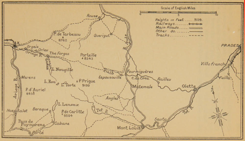
THE ARIÈGE & TET VALLEYS
VIII. The Canigou
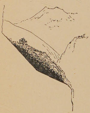
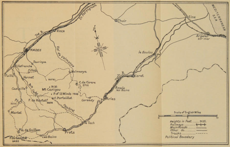
The Canigou, whichever way one looks at it, is a separate district and must be separately approached and separately travelled in. It stands apart from the rest of the range, it has a different character, and travel in it is of a different sort from other Pyrenean travel. It is not only physically cut off from the rest of the Pyrenees, indeed, its physical isolation has been a good deal exaggerated by people who have looked up to it from the plain and have not carefully noted its plan; it is rather morally cut off by the way in which it dominates one particular province and one famous plain to the exclusion of every other peak; so that when you are going through the Roussillon, especially along the sea coast, the only thing you can think of is the Canigou, which seems to be as much the lonely spirit of the district, as Etna does of the sea east of Sicily, or as Vesuvius does of the Bay of Naples. It will perhaps sound surprising or unlikely to those of my readers who know the Pyrenees, when I say that the Canigou is not physically isolated from the chain, it is indeed less isolated in its way than is the Pic du Midi de Bigorre, or even the Pic du Midi d’Ossau, for it is connected with the south by a high ridge which one can hardly ever see at full length from the plain, and which is, I think, only clearly observable from the frontier heights south of Arles upon the Tech. How thorough is the connexion, however, what follows will show.
The Canigou is somewhat over 9000 feet in height, to be accurate 9135, yet it is but the terminal point and not the highest point in a long ridge which runs south-westward to the frontier at the Roque Couloum. It next forms that frontier for 15 or 20 miles, and is then continued past the Port de Col Toses into Spain, where it forms the magnificent wall of the Sierra del Cadi.
A man without heart or vision would see in the Canigou nothing but the last northern point of that long range, but the political accident which makes the Roussillon French, the cross chain which springs from the Pic de Couloun and runs to the Mediterranean, and above all the aspect of the mountains from the civilized wealthy plain to the north and east (where the connecting ridge cannot be seen), and its false appearance of isolation when one observes it from the sea, all make of the Canigou one of the most individual mountains in Europe.
There are, as I have said, many heights in its own ridge, further to the south and west, which surpass it. The Donyais is within a few feet of it, the Enfer or Gous and the Pic du Géant next door, above the valley of the Tet, are higher; the Puigmal just on the watershed is much higher. The summit of the Canigou is but 1500 or 1600 feet above the crest of the ridge in its own immediate neighbourhood, and even the lowest point in that ridge (the Col de Boucacers) is not 2000 feet below it. Nevertheless, it produces, as I have said, an effect of unity and of isolation, and there is not only the illusion of its outline as seen from the north and east, but also the fact that the mountain spreads out in a fan of ridges from its summit to the lowlands all around, and stands upon a broad expanded base, more or less circular in shape, spreading from the Tech upon the south to the Tet upon the east, north, and west.
The Canigou is not a mountain that gives one any climbing to speak of, or that affords any problems or difficulties. There is even, nowadays, a carriage road most of the way up on the northern side, but it is the best place for camping and changing camp that you can find anywhere. All the flanks of it are covered with a series of dense woods; they form a belt 2 or 3 miles deep (in places nearly 5) and running almost continuously round the whole mountain, a circuit of at least 30 miles. Your choice for halting and camping places in these woods is infinite, there is water everywhere and you are nowhere too far from provisions. If you will take the road from Villefranche up to Vernet you will, at that village, be near the steepest side of the mountain and a wood which everywhere affords excellent camping ground. By following up the path to Casteil and taking the track which leads south and east from that hamlet, you are at the inhabited point nearest to its summit, and you have wood and water up to the last mile in distance, or the last 2000 feet in height; but remember, if you wish to make for the summit by this trail, that you must always bear to the right as you walk, choosing always the right-hand trail when there is a diversion, and coming out on the south side of that ridge which has the summit at one end and the Peak de Quazémi at the other. On the open part of this steep bit there is a definitely marked path which follows the left bank of the stream until it is right under the last rocks of the Canigou and then makes straight up by zigzags. If you would go the easier way which everybody takes, you must start from Prades, which is the town of the mountain, and in which anyone will show you the house where the local agent of the French Alpine Club is ready with information.
Your road goes through Taurinya (or if you start from Villefranche, through Fillols), and the new carriage road runs up the ridge between the two valleys—the valley of the Fillols and the valley of Taurinya—first over open country, then through wood until you come to quite the upper part of the Taurinya, where the road turns round the steep corner overhanging the sources of the torrent. This particular wood is called the wood of Balatag, a word that is not so hard to pronounce in Catalan as in French, for the Catalans add an “e” at the end of it.
The road does not go to the actual summit, but comes out on to the shoulder of the mountains, an open space looking to the north, north-west and east, where stands the hotel which has been put up by the French Alpine Club. This hotel is not quite 2000 feet below the highest summit which lies exactly to the south of it. The other summit to the north-east, the ridge of which comes round behind the hotel, is the Pic Puigdarbet. You must allow five or six hours to get to the hotel without haste from the valley of the Tet, and the road is somewhat shorter if you start from Villefranche, than if you start from Prades, but of the two ways, much the more interesting for a man on foot is the old way by Casteil and the Brook Cady which I first described. Here you can camp half-way up the mountain without fear of disturbance from travellers, choosing, for preference, the end of the wood just under the summit, and so make that summit at dawn.
Unless you are in a hurry to get on to Perpignan, one of the best ways of treating the Canigou is to go across it from the valley of the Tet into the valley of the Tech, and from Arles on the Tech to take the railway through Ceret and Elne to Perpignan.
It is of course a long way round, but it shows you both sides of the mountain.
You could hardly get right across the main ridge from the hotel; but you can take the path that goes round the northern flank of the mountain, that is, through the wood that clothes the buttresses of the Pic Bargebit, and that comes out in the valley of the Dalmanya, a torrent running down north-eastwards from the summit. If you are afraid of losing your way you can go down into the village of Dalmanya and up thence by a clear path from the church of the village to the iron mines under the Col de Cirere; from that col there is a very winding high road (of which of course you can cut off most of the turnings) which gets you down to Corsady and so to Arles. On the southern side of the mountain you can go down the path which follows the Brook of Cady, and do your best to note the Peak of the Thirteen Winds which is the peak precisely due south of the main summit and 3000 feet from it at the end of the long ridge. When you have made quite certain which is the Peak of the Thirteen Winds, cross the brook, and work up if you can to the saddle immediately south-west of it, and between it and the Pic de Routat, which is a trifle lower and rises a thousand yards to the south-west of the Peak of the Thirteen Winds.
This col is called the Portaillet, and the valley on the further side is called “The Old or Abandoned Pass.” When you have got across you will know why. A wood covers its lower part, and a little brook called the Cambret runs through it, but there is no regular path, and it is a business to find the first huts, which are at an open space upon the stream between it and the wood, and quite 4000 feet below the col.
The descent is exceedingly steep, and there I leave it.
From these huts (which are called St. Duillem) is a good plain path down to the Tech, and to the little hamlet which has the same name as the river (Le Tech) whence the national high road takes one in 6 miles to Arles, the more usual crossing (which is not really a crossing of the mountains at all, but a crossing of the ridge to the south of it) is by the Pla de Guillem, so called because it does not go near Guillem, and this way is as plain as a pike-staff. You take the road from Villefranche to Fuilla, which is not quite 3 miles off, first up the Tet, then to the left southwards up a lateral valley, you follow that lateral valley and the high road up it from Fuilla to Py, rather more than 5 miles on, and southward all the way from Py a path goes south-west up the right bank of a torrent which comes in there. The track is quite clear and carries you up to the sources of the stream, and to the saddle in the final ridge which is called the Pla de Guillem. It is a steep climb of nearly 4000 in rather more than 4 miles. Py at the junction of the streams is just over 3200 feet above the sea. The pass is about 7000.
On the further side also the track is quite plain, pointing down due south-east through a little wood and then over the open country. It takes you down to Prats de Mollo, a jolly little town, the last on the great national road and the highest in the Tech valley. Above it the national road becomes the local road leading to the baths and waters.
So late as the Revolutionary Wars Mollo was of importance and may be again, for the Spanish armies could come over (but not with guns) from the other Mollo, which lies beyond the frontier 7 or 8 miles off south-east, over the Col of Arras. Mollo is a little lower than Py, but the descent upon it is far less steep than was the ascent upon Py. From Mollo it is somewhat more than 10 miles to Arles by the national road down the valley.
The Canigou is so particular a thing that if a man has but little time before him, or if he already knows the other Pyrenees—he might do worse than go to Perpignan and spend a week upon that mountain. It should be remembered that you have a better chance of fine weather there than in any other part of the Pyrenees, and you will usually have dryer days upon the Tech side than upon the Tet side.
With these eight divisions I have roughly covered the chain of the Pyrenees for those who may, like myself, think that all travel on these mountains should be on foot. It is, of course, but a very rough and general survey, but it would give one, all taken together, a comprehensive knowledge of the chain. My limits have necessarily excluded very many valleys, some of which are unknown to me, such as the valley of Isaba. Among those which I have not dealt with should be considered especially the Ribagorza, which is the boundary between the Aragonese and the Catalan tongues, and runs parallel to Pallars or the valley of Esterri, and can be reached from the valley with some difficulty by Espot and the high Portaron above it, or much more easily from Viella in the Val d’Aran, by the high Port de Viella, which leads straight into the Ribagorza and down to Bono. There are also entrances in and out of Andorra, of which I did not speak, notably the Porte Blanche, which you make from Porta in the Val Carol, a mile or two south of Porté. This way involves two cols, one very high one, the Porte Blanche, another lower one immediately after, the Port de Vallcivera. It is, however, the shortest way from a French high road to Andorra the Old. There is another way in and out of Andorra, very little used, by the Col de la Boella from Ordino to the Val Farrera. All the Basque valleys besides those I mention, and notably that of the Isaba, are places that should be known, and of the passages over the range, which I have not dealt with in detail, one, the road from St. Girons to Esterri by the Port de Salau, will soon be an international highway. It presents no difficulties and no very considerable interest. But if the traveller finds himself by some accident in St. Girons with but a day or two in which to see Spain, here is a very easy way of getting over into what is still one of the remotest parts of that country.
THE CANIGOU