DOCUMENTS. (continued 3)
Reading edition
On the 16th do. at daybreak we again weighed anchor; the wind being W.S.W., we went over nearly to southward. At noon we were in Latitude...degrees...minutes [*]. The wind then turned first to the west and afterwards to the north, so that we could sail on a south-west course; towards the evening we saw the rocks on which our good ship Batavia had miscarried, and I was sure I saw the high Island, but our steersmen contended that it was other land. Two hours after sunset we again came to anchor in 26 fathom fine sandy bottom.
[* Left blank.]
On the 17th do. at daybreak we again weighed anchor with a northerly wind; we were now still about 2 miles from the high island and made for it. When at noon we had got near the island we saw smoke rising up from a long island, two miles to westward of the wreck, and also from another islet [*], close to the wreck, at which we were all of us greatly rejoiced, hoping to find the greater part [**] or almost all the people alive. Therefore, when we had come to anchor, I went in a boat to the highest island, which was quite close to us, taking with me a cask of water, a cask of bread, and a small keg of wine; when I had got there I did not see any one, at which we were greatly astonished. I sprang ashore...
[* This islet was named Batavia's Kerkhof [Churchyard] by the survivors; another of the rocks got the name of Robben-eiland [Seals' island].]
[* This proved actually to be the case. I have thought it needless to print those parts of the journal which tell the adventures of the castaways, since they have repeatedly been narrated in other works.]
On the 15th [of November, 1629] the wind was S.S.W., with seemingly fine weather. Therefore, in the name of God, we weighed anchor and set sail from these luckless Abrolhos for the mainland on an East-north-east course, for the purpose of seeking there the skipper and four other men, who on the 14th last were with their boat cut off from ship by a storm, after which we had resolved to continue our return-voyage to Batavia with the utmost expedition. The spot where the ship or wreck lies, is in 28° 36' or 40', and the place near the high Island where we have been at anchor with the Yacht, in 30 or 32 minutes, north-north-west of the wreck. But after the shipwreck the steersmen had in one of the islands taken the latitude Of 28 degrees 8 minutes, and 28 degrees 20 minutes, which mistake has caused no little loss of time and misunderstanding on our part in seeking out these places...
{Page 61}
The sea abounds in fish in these parts; they are mainly of three kinds, but very different in shape and taste from those caught on other coasts. All the islands about here are low-lying atolls or coral-islets and rocks, except two or three large islands, in one of which, a long time before we came here, they had found two pits filled with water, but during the time we were here, the water in these pits became very brackish or salt, so as to be unfit for human consumption. In the other island, near which the Yacht lay at anchor, after burning away the brushwood or thicket, we also came upon two pits filled with water, which were discovered quite by accident...since they had only a small hole at top, that would admit a man's arm, but below we found a large cistern or water-tank under the earth; after which with mattocks and sledge-hammers we widened the hole so as to be able to take out the water conveniently. Besides, we found in these islands large numbers of a species of cats, which are very strange creatures; they are about the size of a hare, their head resembling the head of a civet-cat; the forepaws are very short, about the length of a finger, on which the animal has five small nails or fingers, resembling those of a monkey's forepaw. Its two hind-legs, on the contrary, are upwards of half an ell in length, and it walks on these only, on the flat of the heavy part of the leg, so that it does not run fast. Its tail is very long, like that of a long-tailed monkey; if it eats, it sits on its hind-legs, and clutches its food with its forepaws, just like a squirrel or monkey. Their manner of generation or procreation is exceedingly strange and highly worth observing. Below the belly the female carries a pouch, into which you may put your hand; inside this pouch are her nipples, and we have found that the young ones grow up in this pouch with the nipples in their mouths. We have seen some young ones lying there, which were only the size of a bean, though at the same time perfectly proportioned, so that it seems certain that they grow there out of the nipples of the mammae, from which they draw their food, until they are grown up and are able to walk. Still, they keep creeping into the pouch even when they have become very large, and the dam runs off with them, when they are hunted.
In these two islands we also found a number of grey turtle-doves, but no other animals. Nor is there any vegetation beyond brushwood, and little or no grass. This and what has hereinbefore been related is all that we have experienced and met with about these Abrolhos.
We shall therefore now shape our course for the mainland of the Southland, to which we are navigating. About noon we were close inshore, running along the coast with small sail at about half a mile's distance from it, in order to see if we could not descry any men or signs of men, until the afternoon, when we saw a small column of smoke rise up from the higher land, but it soon vanished. Nevertheless we anchored there in 21 fathom fine sandy bottom, in order to look for the skipper with his men, but the smoke did not appear again, and no one showed on the beach, from which we concluded that the smoke had been made by the natives, who now did not venture to show themselves. As it blew very hard, we remained at anchor here for the night.
On the 16th do. in the morning we weighed anchor again with a S.S.E. wind and a top-gallant gale. We again ran close along the land with small sail at about a howitzer's shot's distance from the surf. Towards noon we sighted the inlet which we had meant to run into on the 8th of June last, when we were seeking water with the pinnace, and {Page 62} where we were befallen by a storm from the north-west, which would certainly have sent us to destruction, if God had not miraculously saved us. Here we saw divers smoke-clouds rising up, which gladdened us all with the hope that our men might be there. I therefore sent the pinnace ashore directly for the purpose of getting certain information regarding the place and the clouds of smoke we had seen; the men in her, after rounding a steep point, where we had suspected the presence of water, discovered a running streamlet, of which the water was brackish near the sea, but quite fresh higher up; they also found a great many human footprints and continuous footpaths leading to the mountains, and saw numerous clouds of smoke, but the blacks kept themselves in concealment, and no human being was seen.
Formerly, when we were sailing about here with the pinnace, we had also been close inshore, but did not then see any men or smoke-clouds at this place. Thinking this a fitting opportunity, I have here sent on shore the two condemned delinquents [*] Wouter Loos and Jan Pelgrom de By, of Bemmel, in a sampan provided with all necessaries. God grant that this punishment may ultimately redound to the service of the Company, and that the two delinquents may come off with their lives, so as to be able to give trustworthy information about these parts. This inlet is in 27° 51'. In the afternoon, seeing there was no hope or chance of finding the skipper, we made sail and shaped our course to north-west, two points off the land, because it began to blow hard, and in the evening we turned to west-north-west...[**].
[* They had been sentenced to being marooned.]
[* The ship returned to Batavia on the 5th of December.]
XXIV. (1635) [*]. FURTHER SURVEYINGS OF THE WEST-COAST OF AUSTRALIA BY THE SHIP AMSTERDAM UNDER COMMANDER WOLLEBRAND GELEYNSZOON DE JONGH AND SKIPPER PIETER DIRCKSZ, ON HER VOYAGE FROM THE NETHERLANDS TO THE EAST INDIES.
[* In 1629 the west-coast of Australia in the neighbourhood of Dirk Hartogsz Roads was touched at by Dutch vessels, and in 1632 the Trialls were passed by Dutch ships on the outward voyage. What we know about these two points is of no interest as regards our subject.]
Journal of Commander WOLLEBRAND GELEYNSZOON DE JONGH. [*]
[* I know this journal only from what LEUPE extracts from it in his "Zuidland", pp. 62 ff. (the passages in question being given above), and from certain written notes from Leupe's hand. From the latter I have learned inter alia, the name of the skipper, the date of departure from the Texel (December 26, 1634), and the date of arrival at Batavia (June 24, 1635).]
...[May 25] Last night when two glasses of the first watch were out, we got a slight breeze from the N.W., which gradually stiffened, so that there was a fair breeze at the latter end of this watch, which kept blowing through the night till the following forenoon, when the wind turned to W. by N. and W.N.W. with a squall of rain, it blowing a strong top-gallant gale until the evening, course kept E. by N. until one hour after daybreak when we sighted the South-land.
We went over to port directly, keeping a N.E. and N.E. by E. course until noon, when we stood out to sea from the land, on a W. and W. by S. course with a top-gallant gale. We took the latitude, which we found to be 25° 16' South, but of {Page 63} this we are not quite sure; we were not able to take the sun's azimuth, either in the morning or in the evening; we sailed 20 miles until we saw the land, from which we were at 4 or 4½ miles' distance by estimation, on an E. by N. course, and on various courses during the day, course N.N.E. for 6 or 7 miles.
We had made this land in 4 months and 20 days. We saw a good deal of rock-weed floating past our ship, and also a small Saturn-gull, and not above 6 or 7 other gulls; the swell ran strongly from the south-west and afterwards more from the south; along the land the sea was tolerably smooth.
We adjusted our compasses at 4° north-westerly variation. In the morning of the same day about two hours after sunrise, when prayers were over, we saw the south-land straight ahead to the great joy of all of us; it was east of us, at about 3 or 5 miles' distance by estimation, when we got sight of it; it was a low-lying coast extending mainly N.N.E. and S.S.W. as given in the chart, so far as we could see. We immediately began to sail close-hauled to port on a N.E. and N.E. by E. course, sometimes a little higher and at other times a little lower, until three glasses in the afternoon had run out, when we got a squall of rain with the wind going over to W.N.W., upon which we ran north again, since at noon owing to the nearly contrary wind we had gone over to W. in order to keep off the land. We now shaped our course to north, at times to N. by W. nearly as high as we could sail and the wind would allow us.
The land which we saw, and from which at noon we were at no more than 1½ or two miles' distance by estimation, we judged to be the land of d'Eendracht, and the land which we were near to at noon Dirck Hartochsz-Roads, for we had before us a large bay or bight between two capes. In the bay we could see no land from the main-topmast, but so far as we could discern the surf ran through the whole bay from the one cape to the other.
The land shows various white plots near the seaside, and in many places rises very steeply so far as we could see.
The breakers on the coast were very strong, but there were no rocks or shallows near the coast on which we could see the surf break, except at the cape north of Dirck Hartochs Roads, off which there seemed to be a small shoal or rock on which the surf broke, but it may as well have been a landspit running southward out to sea from the cape.
As soon as we got sight of the land, we cast the lead, and took soundings in 90 fathom whitish sandy bottom with small shells, at about 4½ or 5 miles' distance from the land; in the middle of the forenoon we cast the lead again and touched the bottom in 75 fathom coarse and fine sand, mixed with small shells, at a little under 3 miles' distance from the land; we saw a good deal of rock-weed float alongside.
At noon we sounded in 55 fathom, at about two miles' distance from the shore, straight in front of Dirck Hartochsz Roads, greyish sand.
{Page 64}
About 2 o'clock in the afternoon we sounded in 50 fathom white, clean sand-bottom, with very small, thin shells, at about i½ mile's distance by estimation from the northern extremity of Dirck Hartochsz. Roads, and two miles from the southern extremity of the road-stead just mentioned.
Towards the evening after supper, we cast the lead and sounded in 50 fathom grayish sand-bottom, at about 2½ miles' distance by estimation from the land, and about 3 miles to northward of Dirck Hartochsz Roads.
At night when 4 glasses of the first watch were out, we cast the lead and sounded in 50 fathom grayish sand with small shells, estimating ourselves to be about 3 miles off the land, and about 7 miles to northward of Dirck Hartochsz. Roads.
At the latter end of the first watch when seven glasses were out, we cast the lead and touched the bottom in 48 fathom, but could not make out how far we were from the land (since it was night, and we could not see the coast), except from our course, by which we estimated the distance to be 4 miles.
In the second watch when three glasses had run out, we cast the lead again and sounded in 47 fathom sandy bottom as before; we kept sounding every two or three glasses during the whole night until sunrise and found 80 fathom sandy bottom; we saw no land, but from our course and rate of progress we deemed ourselves to be at 9½ miles' distance from the nearest land, estimating our latitude, from the observation we took on the 26th do. at noon, and from our rate of progress, to be 24° South. But we did not see any land again throughout the day, and left off sounding, since our skippers and steersmen, judging from their estimations and from the course we kept (being north, and two points off the land according to the trend of the coast), were of opinion that we could get no bottom, so that we thought it needless to go on sounding...
XXV. (1636). NEW DISCOVERIES ON THE NORTH-COAST OF AUSTRALIA BY THE SHIPS KLEIN-AMSTERDAM AND WESEL, COMMANDED BY (GERRIT THOMASZOON POOL AND) PIETER PIETERSZOON.
[* Pool was killed on the South-west coast of New Guinea, April 28, 1636, and was succeeded in the command of the ships by Pieter Pieterszoon. Unlike my treatment of Carstensz's voyage in 1623, the present account will not embrace the further discovery of the South-west coast of New Guinea. I had to give the route followed along this coast in 1632 because it throws light on the expedition under Willem Jansz. in 1605/6.]
A.
Instructions for Commander Gerrit Thomasz Pool and the Council of the Yachts Cleen Amsterdam and Wesel, destined for the discovery of the lands situated east of Banda, and furthermore of the South-land, thence extending to the South-west.
Inasmuch as for a long time past the "Heeren Majores" have been very instantly recommending to us the discovery of the South-land, and still continue to do so, and we have frequently discussed the matter with...even before his departure, therefore it has been resolved and determined in the Council of India that you shall be employed with the Yachts Cleen Amsterdam and Wesel in the said discovery of the lands east of Banda and of the South-land extending to westward.
You will set sail from Amboyna for Banda, in the name of God, With the said yachts Cleen Amsterdam and Wesel on the first of April next, and when you shall have arrived there, you will communicate these Orders and Instructions to the Lord Governor Acoley.
Whom by these presents we enjoin to hand you in writing all such ampler information as during his residence at Banda His Worship shall have collected touching the {Page 65} lands and islands situated east of Banda, at the same time letting you know where and in what islands His Worship thinks some profit to be obtainable for the Company, or how massoye bark and fitting men may be got, which order will in that case have to be first executed.
And in case you should obtain no additional information, we would have you set sail from Banda as speedily as possible for Arnhems- and Speults land, situated between 9 and 13 degrees Southern Latitude, discovered A.D. 1623, as you will more fully see from the appended chart; these are the large lands; you will endeavour to ascertain what may be obtained from there, whether these lands are peopled, and what the natives subsist on.
After touching at the said islands you will cross over in order to strike the land of Nova Guinea likewise discovered A.D. 1623, by the Yachts Pera and Arnhem as far as 17° 8' Southern Latitude, which we surmise to be the South-land extending to westward from the said latitude as far as 26 degrees or as far as the land of de Eendracht.
The men of the Yachts Pera and Arnhem have, as before mentioned, sailed along this coast from about 4 degrees to 17 degrees 8 minutes, and have landed at various places, where they found nothing but barren coasts and lands, and utterly barbarian, cruel, wild natives, who surprised nine of our men fishing, and assassinated the same. The various strands, rivers, bays, points and the trend of this coast you will gather from the chart aforesaid.
From the farthest point discovered, which as before mentioned, is in Lat. 17° 8' South, you will skirt the coast as far as Houtmans Abrolhos in 28 and 29 degrees, and farther still, if your provisions hold out, if the condition of your crews will allow of it, and if your Yachts are proof against the rough seas that prevail in the Southern Ocean in 33 and 34 degrees; after which you will return to Batavia through Sunda Strait, trying in passing to touch at the Trials, that further information about this rock and its situation may in this way be obtained.
In sailing along the coast you will have all bays and inlets you may meet with, diligently examined, and keep a sharp look-out for the discovery of channels or openings that might afford a passage into the South Sea, since we surmise that such passage must be looked for to northward rather than to southward, considering the breadth of the South-land between 28 and 32 or 33 degrees.
In case you should discover channels leading to the South Sea, or should find the South-land to consist of islands, you will endeavour to pass through or between the same, diligently observing the mouths and outlets, and then returning again through the same passage in order to proceed with your discovery along the north-side.
In landing with small craft you will use great circumspection, and your treatment of the natives that should allow you to come to parley, must and ought to be marked by great kindness, wary caution, and skilful judgment; slight misdemeanours on the part of such natives, such as petty thefts and the like, which they should commit against you, you will suffer to pass unnoticed, that by so doing you may draw them unto you, and not inspire them with aversion to our nation. Whoever endeavours to discover unknown lands and tribes, had need to be patient and long-suffering, noways quick to fly out, but always bent on ingratiating himself.
We have put on board your ships various kinds of merchandise and minerals, which you will show to the people whom you should come to parley with, partly that by so doing you may come to know whether any of these goods are produced by their country, partly in order to see what desire and inclination they evince to our mercantile commodities, and what goods they might be ready to offer in exchange for the same.
{Page 66}
Close attention should be paid to the disposition of the people, their character, condition and humours; to the religion they profess and to their manner of government; their wars, their arms and weapons; the food they eat and the clothes they wear, and what they mainly subsist on.
Careful observation should be made, and exact records kept, of the winds and currents, the rains and tides etc. which you shall meet with in this your intended voyage.
You will make due observation also of all lands, islands, strands, rivers, bays, points, rocks, reefs, cliffs, shallows and whatever else appertains to the same; of all which you will have accurate surveyings made, showing the true bearings, longitude and latitude, in accordance with the circumstances under which you shall get sight and knowledge of the same.
For this purpose availing yourselves of the services of Subcargo Pieter Pietersen...
You will not carry off with you any natives against their will, but if a small number of them should be found willing to come hither of their own accord, you will grant them passage...
Commander Francisco Pelsert, having A.D. 1629 put ashore there two Dutch delinquents, who had in due form of justice been sentenced to forfeit their lives [*], you will grant passage to the said persons, if they should be alive to show themselves, and should request you to be brought hither.
[* See ante, p. 62.]
It would be a thing highly desirable for ships bound from the Netherlands to India, if on the coast of the South-land between 26 and 28 degrees a fitting place for obtaining refreshments and fresh water could be discovered, seeing that mainly about that latitude scorbut and other disorders begin to show themselves, at times carrying off numbers of men even before they reach Batavia.
Finally, as hereinbefore mentioned, we shall expect you back here through Sunda Strait, if no obstacles come in your way to prevent this, and if the land is found to extend in one unbroken coast~line, as we surmise it to do, of which your experience will be our teacher.
It should furthermore be noted that we are convinced that the west-coast of Nova Guinea, or the land discovered as far as Lat. 17° 8' South by the Yachts Pera and Arnhem, forms one whole with the South-land, a point which in drawing up these Instructions we have taken for granted.
Therefore, if you should find the contrary to be the case, a matter of which we will by no means deny the possibility, and if the South-land should by you be found to be an island, you will sail southward along the coast of Nova Guinea, as far as the 32nd degree S.L., and thence on a westerly course touch at the eastern extremity of the South-land, which in January 1627 was discovered by the ship t'Zeepaart. When you shall have made the South-land on this course, you will run one degree more to southward near the islands of St. Pieter and François, that by so doing you may obtain full certainty that from that point the coast-line trends to westward. After which you will run northward again, skirting the Southland, past de Witsland, as far as Houtman's shoal and furthermore to 33 or 34 degrees, if wind and weather shall permit, returning thence to Batavia, as hereinbefore mentioned.
{Page 67}
In conclusion, we wish you all the blessin of the Lord, a prosperous voyage and safe return, hoping at the same time that this voyage may redound to the advantage of the Company, to the glory of our country, and to your especial honour. Amen.
Done in the Castle of Batavia, this 19th of February, A.D. 1636. (Signed) ANTHONIO VAN DIEMEN, PHILIP LUCASZ, ARTUS GYSELS and JAN VAN DER BURCH.
B.
Daily Register of Batavia.
October 1636.
The 6th do.
This day in the afternoon there arrived here from Amboyna the Yacht Cleyn Wesel, having on board the subcargo Pieter Pietersen, who...after the lamentable assassination of Commander Gerrit Thomasz Pool on the coast of Nova Guinea, had succeeded to the latter's office, and with the Yachts Cleen Amsterdam and Wesel had returned to Amboyna by way of Banda, reporting in substance as follows, both by word of mouth and by the journal kept during the voyage and the Resolutions duly registered, touching what happened in the course of the expedition, to wit...
On the 6th of June [they came to anchor] before the native village of Taranga at the south-western extremity of Arouw, in order...to provide themselves with certain necessaries...
On the 9th of June, being duly revictualled, he had set sail again from the said native village of Taranga, shaping his course to southward in order to endeavour to get to eastward by some means or other, so as to accomplish his ordained voyage; but when he had got to southward as far as the 11th degree of latitude, he had not only found and met with the east- and south-east-winds blowing constantly with great vehemence and hollow seas, but had also come upon a new land; in such fashion that, seeing no chance of getting to eastward for the accomplishment of his voyage, since such voyage will have to take place in the beginning of the western monsoon, he resolved with his council to give up further investigations to eastward, to explore and survey the situation of the newly discovered Van Diemensland, also called Arnhems or Speultsland, and, having gathered the required information, to run northward again for the purpose of obtaining perfect knowledge of the islands of Timor and Tenember; and all this having been duly effected, to return to Banda etc.
In conformity with this resolution the said Pieter Pietersen has surveyed the newly discovered land for the space Of 20 miles from East to West; he has seen many fires and frequent clouds of smoke, but no natives, houses, prows or fruit-trees, although he has paddled close along the shore with an orangbay, and gone ashore in sundry places, finding the land wild and barren; wherefore, not having been able to come to parley with any of the inhabitants, on the 20th of June, as previously resolved upon, he ran to the north from a certain Red point jutting out into the sea to northward, where the land falls off abruptly to the west, for the purpose of making the islands of Timor and Tenember...
{Page 68}
C.
Journal of the voyage to Nova Guinea, 1636.
...In the early morning of Friday [June 6]...we arrived before the native village of Taranga...
On Monday the 9th do. At daybreak the wind was S.E...we set sail from Taranga...shaping our course to the S.S.W.
We could take no latitude at noon...
In the first watch we sailed S.S.W. the space of about 3 glasses; the wind was S.E. with a fair breeze, and afterwards E.S.E.; we sailed to southward for the time of 12 glasses; at the beginning of the day-watch the wind was E.N.E. with a fresh breeze; we sailed S.E. for about eight glasses...
On Tuesday the 10th do. In the morning about breakfast-time the wind blew from the E.N.E. as before...
We estimated ourselves to have sailed 9½ miles on a generally Southern course from last night to the present night.
On Wednesday the 11th do. Course held S.S.E...We had sailed on a Southern and S. by E. course about 11 miles by estimation during the last 24 hours...
On Thursday the 12th do. The wind E.S.E. as before...At noon we were in Lat. 10° 2', so that I find we are farther to southward as would accord with our estimation and our courses kept, on which account I believe the current must have driven us a good deal to S.S.E.. In the afternoon the sky was overcast, the wind E.S.E. and S.E. by E. with a light breeze; we sailed to S. by W. with our mainsails set. Towards the evening the water became all of a sudden very smooth and of a pale colour; after sunset we cast the lead in 40 fathom good anchoring ground, fine sand, but could see no land: we took in our foresail and sailed in the night with the mainsail only to avoid press of sail. We estimated ourselves to have sailed about 12 miles on a general S.W. by S. course during the last 24 hours. In the night the wind was E. by S., E.S.E. and S.E. by E. with fine, lovely, clear weather and a top-gallant gale; throughout the night our average course was S., we cast the lead now and then in 42, 39, 38, 36 and 25 fathom good anchoring-ground.
On Friday the 13th do., the wind was nearly S.E., with a top-gallant gale and smooth water; course S.S.W. and S. by W.; the water was very pale in colour, but we could see no land; the weather was lovely and clear; at noon we found ourselves to be in 10° 50' S.L.
Shortly after noon we cast the lead in 32 fathom good anchoring-ground; at four glasses in the afternoon we saw the land S.E. by S. of us, at about 6 miles' distance from us it was a low-lying coast with small hills; about 6 miles farther to westward we also saw land, not connected with the first land, but upwards of three miles distant from the same.
Towards the evening it fell a calm; at sunset there was a faint breeze from the S.S.E.; we made out the extremity of the land to be at about 3 miles' distance S.E. by S. of us; we were still in 32 fathom good anchoring-ground; we accordingly went over to eastward, but when shortly before the setting of the watch, the wind went down still more and began to turn to the N.W., we dropped anchor in 29 fathom good anchoring-ground.
{Page 69}
On Saturday the 14th do. the current began to set to the S.E. in the morning, and the wind to blow hard from the E.S.E., so that we could not carry mainsails then; we weighed anchor and set sail on a South and South-by-east course. The water gradually shallowed, and seeing that we could not make the easternmost land, we ran to the westernmost, where we came to anchor at about a musket-shot's distance from the land in 10 fathom good anchoring-ground. Close along the shore the land is somewhat rock and reefy here; this land extends here about 3 miles S.E. by S. and N.W. by N., both slightly more to South and North. In the afternoon we sent out our small boat to take soundings close inshore; on returning the men reported that until they came to the reefs they had found no less than 3½ fathom good anchoring-ground. Off the point near which we lay at anchor, a river ran landinward; we hoisted the white flag, and caused the little boat to paddle close along the shore. We saw smoke, indeed, in many parts of the inland, but no natives, houses or vessels. This land is not high, chiefly level, thickly covered with trees, and with a sandy beach at the seaside. We had taken no latitude at noon; the tide seems to run from the N.W. here; in the night at the latter end of the first watch we could take the latitude by the stars and found it to be 12° 8' South.
On Sunday the 15th do. at daybreak the wind blew hard from the E.S.E.; it was mainsail weather; we convened the Plenary Council and resolved with the same further to explore this land to the north-west and to use all possible diligence to get knowledge touching the island of Timor, as will be found more amply set forth in this day's Resolution.
As we were weighing our anchor, a lanyard and a pulley got broken; we shaped our course to N.W. by N. and N.N.W. Having sailed the space of about 2 miles, we came to a point, between which point and another point, a distance of about 4 miles, the land extends W.N.W. and E.S.E. with hardly any curve, and with rocks and reefs along the shore. Off this point the surf and the breakers ran very strongly, as if there were a shoal there, seeing that the wind and the current were opposed to each other. We therefore sailed along the coast at less than a mile's distance from the same in 12, 11 and 10 fathom good anchoring-ground. In many places we saw great clouds of smoke landinward, but no fruit-trees, houses, vessels or natives; the land seems to be quite wild. Towards the evening we cast anchor in 9 fathom good anchoring-ground at about half a cannonshot's distance from the land; the aforesaid point was E. by N. of us at upwards of half a mile's distance; during the night we had violent squalls from the E.S.E. with a thick, foggy sky; landinward we observed a number of fires.
On Monday the 16th do. in the early morning the wind blew from the E.S.E. as before with sudden violent squalls. As we were weighing our anchor, the lanyard-pulley broke, and shortly after our anchor-cable snapped off at about three fathom's distance from the anchor, so that we lost the latter. As we were setting our foresail, a musket-shot was fired from the Yacht Wesel, upon which we dropped our other anchor again; when towards the evening the weather had somewhat improved, we sent our orangbay to the Wesel, to learn the meaning of the musket-shot; when the men returned, they informed us that the Wesel had also lost an anchor, but that the buoyrope had remained entire, so that we remained here till the following day in order to recover the same.
On Tuesday the 17th do. towards noon we were informed that the buoy-rope of the Wesel had broken of its own accord close to the anchor, so that they had also lost their anchor, upon which forthwith weighing the anchors of both the Yachts, we found that the cables had also been damaged through rubbing against hidden stones and rocks.
{Page 70}
As beforementioned, the coast here extends W.S.W. for the space of about 4 miles, with hardly any curve; at 3/8 of a mile's distance from the land there is already 8 and 7 fathom, good clayey bottom; the wind still blew from the S.E. and E.S.E. with a steady stiff gale; towards the evening we came to anchor in 7 fathom good anchoring-ground, at about half a mile's distance from the land, having the point E.S.E. of us at less than a mile's distance.
Up to now we have seen no men, vessels or houses; we should certainly have landed with the boats here and there, but that they were both of them stove in, and had first to be thoroughly overhauled before they could be used. During the night the weather was lovely and calm.
On Wednesday the 18th do., the wind blowing from the E.S.E., the weather was calmer, fairer and steadier than before. We gave a coat of tar to both our yachts, and remained at anchor the whole of this day, chiefly in order to see if we could not get sight of natives here or there and come to parley with the same, but we waited in vain for them. During the night the weather was bright, fair and clear, the wind blowing from the S.S.E., S.E., and E.S.E.
On Thursday the 19th do. at daybreak, the wind being E.S.E. with fair weather and a weak breeze, we weighed anchor and shaped our course to W.S.W., slightly more to westward. (The land here extends with a great curve and river as far as the Witte Hoeck [White point], known by the white sand-hill near the strand when you come from the east).
At 4 glasses after breakfast we came near a stony, rocky reef, which we kept outside or to seaward of in 8 and 9 fathom. The eastern extremity of it is less than a mile to the S.W., slightly more southerly, of the Witte Hoeck, and the western extremity upwards of mile to the S.W. by S., slightly more southerly, of the same; the reef extends S.E. by S. and N.W. by N.; it is not very long or broad, and there were violent breakers upon it.
When we had weathered the reef, we again ran W.S.W. at less than a mile's distance from the land, in 8, 9, 7 and 5 fathom good anchoring-ground. From the Witte Hoeck the land trends nearly to W.S.W. with a slight curve, as far as one can see; close to the sea the beach is chiefly sandy, with small, low sand-hills here and there.
The whole day we saw a good deal of smoke landinward; at noon we were in exactly 11° S.L. From this Witte Hoeck the land trends to W.S.W., slightly westerly, with a slight curve for the space of upwards of 3 miles; from there to W.N.W. with a strong curve the space of upwards of two miles, as far as a point, off which point, at less than half a mile's distance to N.E. by E., there is a small island on all sides surrounded by shoals and reefs; beyond this island the land falls off to the S.W., making a curve of 2 miles at least but afterwards it trends to the N.W. again. This island bears from the land about N.W. and S.E.; the beach is sandy with reefs here, and there.
At sunset it fell a calm, and we came to anchor in 8 fathom good anchoring-ground at about a mile's distance from the land, having the island S.S.E. of us at upwards of a mile's distance. Shortly after we saw two fires on the beach beyond the island. We estimated ourselves to have sailed about 8 miles this day; during the night the wind blew from the S. and S.S.W. with lovely weather. We found little or no current running here.
{Page 71}
On Friday the 20th do. we set sail at daybreak with a weak breeze from the S.; we kept mainly at a mile's distance from the land in 7 and 7½ fathom good anchoring-ground. In the course of the day the wind went over to N.E., after which we ran N.W.; at noon we got near the Roode Hoeck [red point], situated N.W. of the island aforesaid at about 5 miles' distance; upwards of half a mile's distance from here the land falls off to W. by W.; from this point a large reef was seen running out to sea the length of upwards of 1½ mile, which reef being unable to weather because we sailed so close to the wind, we came to anchor in 7½ fathom good anchoring-ground, at half a mile's distance from the land; the Roode Hoeck was S.W. and S.W. by S. of us at upwards of half a mile's distance; we saw smoke rising in various places.
On Saturday the 21st do. we set sail with a S.S.E. and S.E. by S. wind, a weak breeze and lovely weather. Here, from the point, the land extended to S. by W. and S.S.W. as far as one could see, with a slight curve only. The reef above referred to runs out to sea in a northward direction from the Roode Hoeck upwards of two miles, and from there very far to westward, upwards of 1½ mile from the land. It consists of sandy shoals, having a small hill or rock above water; alongside it the depth was 7, 6, 5 and 4 fathom, uneven bottom. And since the wind blew from the S.E. by S. as before, so that we could not make the land again, we resolved to run N.E. We accordingly shaped our course to the N.N.E. for the purpose of touching at Timor with the help of Almighty God, and take surveyings of the same.
In or near this land, which in our chart [*] we have named Van Diemensland, we have seen no men, houses, fruit-trees or prows, although we ventured to inspect it paddling with our orangbay close along the shore; the boats of both the yachts being unfit for use, stove in, and under repair. About 2 glasses after noon, the wind was N.E., N.N.E., and N.E. by N. with calm and steady weather. At sunset we estimated ourselves to have the Roode Hoeck S.S.E. of us at 6 miles' distance; during the night there was a weak breeze from the E.S.E., N.E. by E. and also N.E.; course held N.N.W., N. by W. and also N., with bright, lovely and clear weather.
[* This chart is wanting.]
On Sunday the 22nd do. in the morning the wind was E.S.E. with a lovely breeze and top-gallant weather; course held N.E. At noon we took the latitude and found it to be 10° 10' South...[*]
[* The further progress of the voyage has no interest connected with our present subject.]
{Page 72}
XXVI. (1642-1643). DISCOVERY OF TASMANIA (VAN DIEMENS LAND), NEW ZEALAND (STATENLAND), ISLANDS OF THE TONGA AND FIJI GROUPS, ETC. BY THE SHIPS HEEMSKERK AND DE ZEEHAEN UNDER THE COMMAND OF ABEL JANSZOON TASMAN, FRANS JACOBSZOON VISSCHER, YDE TJERKSZOON HOLMAN OR HOLLEMAN, AND GERRIT JANSZ(OON).
See Frederik Muller and Co's Tasman Folio.
XXVII. (1644). FURTHER DISCOVERY OF THE GULF OF CARPENTARIA, THE NORTH- AND NORTH-WEST-COAST OF AUSTRALIA BY THE SHIPS LIMMEN, ZEE MEEUW AND DE BRACQ UNDER THE COMMAND OF TASMAN, VISSCHER, DIRK CORNELISZOON HAEN AND JASPER JANSZOON KOOS.
A.
See Frederik Muller and Co's Tasman Folio.
B.
Letter of the Governor-General and Councillors to the Governor of Banda, November 29, 1644.
...We shall not recount here how...Tasman had coasted along the land of Nova Guinea and the South-land without finding any channel or opening up to Willems River, from where he has returned hither through Sunda Strait, but would refer Your Worship to the annexed extract from their journals, which we request you to peruse with attention, and to order...Dortsman [*] or any other person whom you shall charge with the voyage to Timorlaut, in case their plans touching these islands should succeed speedily and prosperously, and they should still have time at their disposal, to make for the great river which our men have christened Waterplaets, in 12 degrees Southern Latitude and 160¼ degrees Longitude, to sail up the same river landinward, in which there is the less difficulty, since the river, being deep and wide, can be sailed up by the yacht, which can conveniently turn, veer and tack in it...
[* Adriaan Dortsman had been ordered on a voyage of discovery east and south of Banda. This voyage took place in 1645 and 1646, but Australia was not visited on that occasion.]
{Page 73}
XXVIII. (1648). EXPLORATORY VOYAGE TO THE WEST-COAST OF AUSTRALIA ROUND BY THE SOUTH OF JAVA, BY THE SHIP LEEUWERIK, COMMANDED BY JAN JANSZOON ZEEUW.
A.
A.
Instructions for the officers of the Yacht den Leeuwerik...June 27, 1648.
Having learned by the ships last arrived here from Banda, what poor rice-crops they had in those quarters last year, so that, had not they received some timely supplies of this grain from Amboyna, they would have been put to exceeding inconvenience; and having besides seen from the letter of Governor Cornelis Willemse van Outhoorn that also this year they are under serious apprehensions of the like scarcity, in case supplies from Batavia should be long in coming.
Therefore we have lately resolved in our Council to make an express shipment thither at this time of year...chiefly and principally that, if this voyage should have the expected success, which may the Almighty grant in His mercy, we may in future be sure that such voyage could be made every year after the arrival of the first ships from there, and the said important Government be by us duly assisted...as regards rice and other necessaries.
This Yacht, which we consider to be of strong build and a good sailer, having by us been assigned for this purpose...you will weigh anchor in the name of God early to-morrow, set sail, and use your utmost endeavours to get clear of Sunda Strait as soon as possible, and thus gain the open...
As soon as you shall have got clear of the Prince islands...you will from there shape your course directly to the south, straight across the sea, thus sailing by the wind without looking right or left, until you shall have come to 32 or 33 degrees S.L., where with the help of God you will meet with the westerly trade-winds; and when you are quite sure of having got the same, without the least doubt on your part, you will direct your course to the South-land, trying to make it and get it alongside in 25 or 26 degrees Southern Latitude, where the coast is generally of easy access, the land being of moderate height and somewhat resembling the coast of England.
Having reached the South-land in such fashion as we have just indicated, you will keep the coast alongside, and not leave the same, but use your best endeavours to skirt it, not parting with it until you have weathered the Vuylen hoecq (Foul Point); after which you may leave the coast, and cross over from there, next using the easterly and south-easterly winds which you will meet with in those waters, for running in sight of the islands of Arou, Tenember and Damme or any of these, and then making straight for Banda with the utmost expedition, which port you will with God's help conveniently reach in the manner hereinbefore described.
As we have already said, the accomplishment of this voyage at this season of the year (in which only strong headwinds are blowing along the ordinary route to Banda and other quarters nearer home) is of very great importance to the Honourable Company...
We herewith hand you a new chart of the South-land, which you may avail yourselves of in due time, and we noways doubt you will find the same of great use to {Page 74} you, of which we hope afterwards to receive your report. Seeing that the waters you are going to navigate are for the greater part little known as yet, and that accordingly many noteworthy things are not unlikely to occur in your voyage, we hereby likewise earnestly enjoin you, not only to keep a complete and elaborate journal of this voyage, but also to make due observation of the direction of the winds, the trend of the coasts, the situation of bays, inlets and capes, and properly to note and make drawings of the same, that on your return you may be able to hand us a full and perfect report of the whole undertaking, thus furnishing fresh material for the correction of the charts now in use, and perhaps also of the courses to be kept...
Given in the Castle of Batavia, June 27, A.D. 1648.
(Signed) CORNELIS VAN DER LIJN, FRANÇOIS CARON, CAREL RENIERSZ, JOCHUM R. VAN DEUTECOM, and GERARD DEMMER.
B.
Letter of the G.-G. and Councillors to the Managers of the E.I.C., January 18, 1649.
...[We have dispatched to Banda] the yacht den Leeuwerck on the 28th of June of last year...through Sunda Strait, in order, if possible, to make the voyage to Banda along this route north of the South-land. Which undertaking has succeeded to our complete satisfaction but especially to the great joy of our Banda people, for which the Almighty be praised...since this success is undoubtedly of great advantage to the General Company, and makes it quite sure that in cases of shipwreck or other accidents we shall always be able to send succour and supplies to Banda and the quarters on this side of it along this newly discovered route...which, on receipt of the first advices in May next, may be done by the route abovementioned along the South-land. How this voyage was undertaken and successfully accomplished as far as Banda in the space of two months and 23 days, your Worships may be pleased to gather from the annexed daily journal and Chart [*] of Skipper Jan Jansz Zeeuw.
[* Journal and chart are both of them wanting.]
Written in Your Worships' Castle of Batavia, this 18th of January, A.D. 1649.
Your Worships' faithful servants the Governor-General and Councillors of India:
CORNELIS VAN DER LIJN, F. CARON, CAREL REINIERS, J. P. VAN DUTECUM, GERARD DEMMER.
{Page 75}
XXIX. (1656-1658). SHIPWRECK OF THE GULDEN OR VERGULDEN DRAAK ON THE WEST-COAST OF AUSTRALIA, 1656.--ATTEMPTS TO RESCUE THE SURVIVORS, 1656-1658.--FURTHER SURVEYINGS OF THE WEST-COAST BY THE SHIP DE WAKENDE BOEI, COMMANDED BY SAMUEL VOLCKERTS(ZOON), AND BY THE SHIP EMELOORD, COMMANDED BY AUCKE PIETERSZOON JONCK, 1658.
A.
Letter of the G.-G. and Counc. to the Managers of the E.I.C, December 4, 1656.
...On the 7th June there arrived here...from the South-land the cock-boat of the yacht den Vergulden Draeck with 7 men, to our great regret reporting that the said yacht had run aground on the said South-land in 30 2/3 degrees, on April the 28th, that besides the loss of her cargo, of which nothing was saved, 118 men of her crew had perished, and that 69 men who had succeeded in getting ashore, were still left there. For the purpose of rescuing these men, and of attempting to get back by divers or other means any part of the money or the merchandises that might still be recoverable, we dispatched thither on the said errand on the 8th of the said month of June [*], the flute de Witte Valeq, together with the yacht de Goede Hoop, which after staying away for some time were by violent storms forced to return without having effected anything, and without having seen any men or any signs of the wreck, although the said Goede Hoop has been on the very spot where the ship was said to have miscarried...[**]
[* The day following that on which the report regarding the Vergulde Draak had reached Batavia.]
[** Some of the men of the Goede Hoop had gone ashore, but had not returned.--The Witte Valk had touched at the Southland, but by "bad weather and the hollow sea" had been compelled to return without having effected anything.]
In the Castle of Batavia, December 4, A.D. 1656. Your Worships' Obedt. Servts. the Governor-General and Councillors of India JOAN MAETSUYKER, CAREL HARTZINCK, JOAN CUNAEUS, NICOLAES VERBURCH, D. STEUR.
B.
Daily Register of Batavia, 1657.
[July] the 8th. Late in the evening there arrived in the road-stead here, and came to anchor, the small flute de Vinck of the Zealand Chamber, which had sailed [from the Netherlands] on December 24, 1656...she came hither via the Cape of Good Hope and the South-land...
The skipper further reports that, according to the order and instructions handed him by Commander [*] Riebeeck, he had touched at the South-land, but it being the bad monsoon on the said coast, they had found it impossible to sail along the coast so far {Page 76} as to look after the wreck and the men of the lost ship den Draeck; for in the night of June 8 (having the previous day seen all signs of land, and the weather being very favourable) they had come to anchor in 29° 7' S.L., and the estimated Longitude of 130° 43', in 25 fathom coarse sandy bottom mixed with coral; the following morning at daybreak they saw the breakers on the reef at the end of which they were lying at anchor, and on one side ahead of them, the South-land, which there showed as a low-lying coast with dunes; upon which they weighed anchor and continued sailing along the coast in order to keep near the land, which was still in sight the day following; but the weather began to become so much worse and the breakers on the coast were so violent, that it was a fearful sight to behold, upon which they shaped their course a little more to seaward. On the 10th and 11th they kept sailing along the coast in 40 or 50 fathom, but seeing their chances of touching at the coast this time get less and less, and the weather continuing very unruly with violent storms of thunder and lightning, they resolved to keep off the coast, and drifted on without sail. On the 12th they made small sail, the wind continuing to blow from the S. and S.S.W., and also from the S.S.E., and shaped their course for Batavia...
[* Of the Cape of Good Hope.]
C.
Letter of the G.-G. and Counc. to the Managers of the E. I. C., December 14, 1658.
...By our previous letters we informed Your Worships that on the first of January last we dispatched from here to the...Southland the galiots De Waeckende Boeij and Emeloort, for the purpose of making search for the crew of the lost ship de Vergulden Draecq, and of ascertaining whether they were still alive. The said ships returned to this place on the 19th of April following, after exploring the coast about the place of the disaster each of them for herself, since they had got separated; having in different places sent manned boats ashore, and fired many cannon shots time after time both by day and night, without, however, discovering any Netherlanders or any traces of the wreck, excepting a few planks [etc.]...which must undoubtedly be looked upon as remnants of the said ship...We herewith hand you the journals of the galiots [*] aforesaid...together with the small charts of the coast drawn up on board each of them[**]...
[* See D and H infra]
[* See E, F and I infra.]
Written in Your Worships' Castle of Batavia, December 14, 1658.
JOAN MAETSUYKER, CAREL HARTSINCK, A.D. V. v. OULDTSHOORN, N. VERBURCH, D. STEUR, PIETER STERTHEMIUS.
{Page 77}
D.
Daily Journal kept by skipper SAMUEL VOLKERSENN on board the flute de Waeckende Boeij, sailing in the same from Battavia to the Southland. A.D. 1658 [*].
[* On December 21, 1657 the G.-G. and Counc. resolved to dispatch to the South-land the ships de Wakende Boei and Emeloord, for the purpose of making another attempt at rescuing what might still be rescued of the men, the cargo, etc. of the Vergulde Draak; "and also to get perfect knowledge, once for all, of the situation and trend of the said coast, with its shoals, reefs and shallows." The journals of the skippers of both vessels are preserved in the Hague State Archives. After mature consideration I have deemed it needless to print the said journals here, seeing that MAJOR, Terra Australis, refers to them on pp. 77-90, and gives the substance of the information contained in them (LEUPE, Zuidland, pp. 105 ff. has printed certain parts of the two journals). But above all, the charts made on this expedition, which are here carefully reproduced, give a more convenient survey of the results of it than could be done by the journals themselves, which for the rest contain little that is of interest for our present purpose.]
E.
Chart of Eendrachisland, 1658, on a small scale.
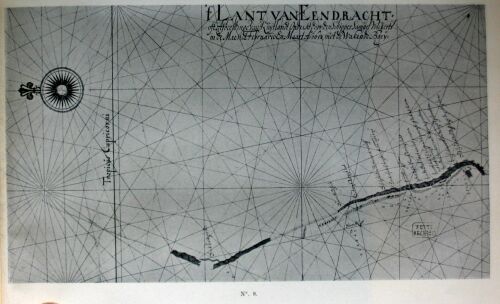
No. 8. Kaart van (Chart of) Eendrachtsland, 1658
{Page 78}
F.
Chart of Eendrachisland, 1658, on a larger scale.
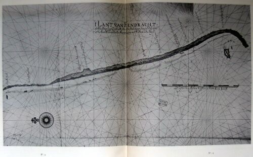
No. 9. Kaart van (Chart of) Eendrachtsland, 1658
{Page 79}
G.
A brief account of the west-coast of the South-land.
The South-land has sandy dunes forming many points on the sea-side; the dunes all consist of loose sand overgrown with grass into which a man will sink up to his ankles, and leave deep footprints on withdrawing his feet.
About a mile more or less off shore, there is as a rule a rocky reef, on which the breakers may be seen to dash violently in many places, the depth above the reef being in several places, 1, 1½ and even 2 fathom, so that pinnaces and boats may get over it for the purpose of landing, there being deeper water close inshore, but all of it with a rocky, sharp coral-bottom, so that it is difficult to land there, and much harder still to keep a pinnace at anchor with a drag; except in a place about 9 miles north of the island, where there are three rocks close to the shore, which are connected by a rocky reef, behind which you may conveniently lie at anchor and effect a landing with pinnaces or boats; but the bottom is foul and rocky everywhere.
Inward, the land is pretty high, with hills of even height, but barren and wild to look at, except near the island where a great many trees are seen.
In slightly under 32° S. Lat. there is a large island, at about 3 miles' distance from the mainland of the South-land; this island has high mountains, with a good deal of brushwood and many thornbushes, so that it is hard to go over; here certain animals are found, since we saw many excrements, and besides two seals and a wild cat, resembling a civet-cat, but with browner hair. This island is dangerous to touch at, owing to the rocky reefs which are level with the water and below the surface, almost along the whole length of the shore; between it and the mainland there are also numerous rocks and reefs, and slightly more to southward there is another small island.
This large island to which we have been unwilling to give a name, leaving this matter to the Honourable Lord Governor-General's pleasure, may be seen at 7 or 8 miles' distance out at sea in fine weather. I surmise that brackish or fresh water might be obtainable there, and likewise good firewood, but not without great trouble.
Two good and certain landmarks of the West-coast of the Southland:
Firstly: If in these regions you observe about 11 degrees variation of the compass, you may be sure of not being at more than 18 or 20 miles' distance from the land.
Secondly: If you see rock-weed floating about, you may be assured that you will sound the bottom in 70, 60, 50, 40, 30 fathom or less.
At foot:
Your obedient Servant (signed) SAMUEL VOLCKERSEN.
H.
Daily Journal kept by Skipper AUCKE PIETERS JONCK, skipper of the galiot Emeloordt, on her voyage from Battavia to the South-land, A.D. 1658 [*]
[* See preceding note.]
{Page 80}
I.
Chart of Eendrachisland, 1658
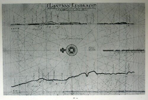
No. 10. Kaart van (Chart of) Eendrachtsland, 1658
{Page 81}
XXX. (1658). THE SHIP ELBURG, COMMANDED BY JACOB PIETERSZOON PEEREBOOM, TOUCHES AT THE SOUTH-WEST COAST OF AUSTRALIA AND AT CAPE LEEUWIN, ON HER VOYAGE FROM THE NETHERLANDS TO BATAVIA [*].
[* The ship Elburg arrived at Batavia on July 16, 1658.]
Letter of the G.-G. and Counc. to the Managers of the E.I.C., December 14, 1658.
...The flute Elburgh, Jacob Pietersz. Peereboom master, in coming hither struck the South-land in 31½ degrees S.L., and the estimated longitude of 117°, where, at about 2½ miles' distance from the land, she was by the strong wind and the hollow sea forced to come to anchor in 22 fathom, not without great peril of being lost; but after 12 days' hard trying they at length got off again and into the open, for which God's name be praised. Meanwhile, in 33° 14' S.L., round a projecting point, they have found a good anchoring-place, where they have been at anchor in 20 fathom, and where the skipper, together with one of the steersmen, the sergeant and 6 soldiers landed round Leeuwinnen cape, finding there three black men, hung with skins like those at Cape de Bonne Esperance, with whom, however, they could not come to parley.
On the spot where the blacks had been sitting, our men found a burning fire, near which there lay a number of assagays, together with three small hammers, consisting of a wooden handle to one end of which a hard pebble was fastened by means of a kind of wax or gum, the whole strong and heavy enough to knock out a man's brains.
A little farther inward they came upon a number of huts, without any persons in them, and in various spots they found rills of fresh water, and here and there large quantities of the wax or gum aforesaid, of which we beg leave to hand you a small sample herewith, together with one of the said hammers, the wax or gum being of a red colour, and emitting an agreeable smell after being rubbed for some time...
XXXI. (1678). FURTHER DISCOVERY OF THE NORTH COAST OF AUSTRALIA BY THE VLIEGENDE ZWAAN, COMMANDER VAN DER WALL, ON HER VOYAGE TERNATE TO BATAVIA, IN FEBRUARY 1678.[*]
[* The ship sailed from Ternate in December, 1677, and arrived at Batavia "by way of Timor and thus along Nova Guinea, without passing through Sunda Strait" (Letter of the G.-G. and Counc. to the Managers of the E.I.C. May 8, 1678).]
Chart of "the north side of the Southland and surveyed with the flute de Vliegende Zwaan in the month of February, by Jan Van Der Wall," A.D. 1678 [*].
[* This chart is the only evidence of this voyage known to me. LEUPE, Zuidland, also, has not found anything else concerning it.]
{Page 82}
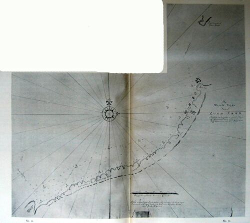
No. 11. Kaart van de Noordzijde van 't Zuidland (Chart of the North side of the Southland), 1678
{Page 83}
XXXII. (1696-1697). FURTHER SURVEYINGS OF THE WEST-COAST OF AUSTRALIA BY THE SHIP GEELVINK, COMMANDED BY THE SKIPPER-COMMANDER OF THE EXPEDITION, WILLEM DE VLAMINGH, THE SHIP NIJPTANG UNDER GERRIT COLLAERT, AND THE SHIP HET WESELTJE, COMMANDED BY CORNELIS DE VLAMINGH. [*]
[* In November and December 1695 the Managers of the E.I. Company (Resolutions of the Heeren XVII of November 10, December 8 and 10, 1695) resolved to dispatch a flotilla to the South-land or the land of d'Eendracht, this time starting from the Cape of Good Hope. Willem De Vlamingh was appointed commander-in-chief of the expedition. He was also instructed to inquire into the fate of the ship de Ridderschap van Holland, which had miscarried on her voyage from the Cape to Batavia in 1694.]
A.
Letter of the Governor-General and Councillors to the Managers of the E.I.C. at the Amsterdam Chamber, November 30, 1697.
...As regards the results of the voyage of the three...vessels aforesaid [de Geelvink, de Nijptang and het Wezeltje], which, pursuant to the letters of the "Heeren XVII" of November 10, 1695, and March 16, 1696, and in accordance with Your Worships' Instructions of April 23 of the same year, have successfully accomplished their voyage by way of the Tristan de Cunha Islands and the Cape of Good Hope, furthermore via the islands of Amsterdam and St. Paulo, and along the land of d'Eendragt or the South-land, and have arrived here in good condition as regards ships and crews, we shall in the main beg leave to refer you to the journals kept on board the said ships, and to their annotations, together with the charts and a number of drawings of the said places, all which will be handed to Your Worships by the bearer of the same, Almoner Victor Victorszoon, who is now homeward bound in the ship Slants Welvaren. The drawings are packed in a case to the number of 11, to wit:
7 of divers places in the South-land, 1 of the island of Tristan de Cunha, 1 of the island of Amsterdam, 1 of the island of St. Paulo, and 1 of the island of Mony [*].
[* I have not found these drawings.--In the seventeenth-century charts Mony is South-west of Java.]
{Page 84}
We besides beg to forward to you a number of larger and smaller disks of wood, brought over from the said South-land by skipper Willem de Vlamingh, concerning which wood he had noted in his journal at the dates December 30 and 31, 1696, and January 2, 1697, that it was odoriferous, a point which we have not been able to verify here, although we have directly ordered a small portion of it to be distilled, and beg to hand you with the rest a small bottle of the oil thus gained for Your Worships' examination...together with a box containing shells collected on the beach, fruits, plants, etc., the whole, however, of little value and decidedly inferior to what elsewhere in India may be found of the same description; so that in general in this part of the South-land, which in conformity with their instructions they have diligently skirted, surveyed and observed, they have found little beyond an arid, barren and wild land, both near the shore and so far as they have been inland, without meeting with any human beings, though now and then they have seen fires from afar, some of the men fancying that two or three times they have seen a number of naked blacks, whom however they have never been able to come near to, or to come to parley with; nor have they found there any peculiar animals or birds, excepting that especially in the Swaene-revier [*] they have seen a species of black swans, three of which they have brought to Batavia alive, which we should have been glad to send over to Your Worships, but that shortly after their arrival here they all of them died one after another. Nor, so far as we know, have they met with any vestiges of the lost ship de Ridderschap van Hollant or of any other bottoms, either in those parts or near the islands of Amsterdam and St. Paulo, so that in sum nothing of any importance has been discovered in this exploratory voyage. Only, we must not omit to mention that in an island situated in 25° S.L. near or before the South-land, they have found fastened to a pole, which though half-rotten stood still erect, a common pewter dish of medium size, which had been flattened and nailed to the pole aforesaid, where they found it still hanging; the said dish bearing the following words engraved on it, still distinctly legible:
[* Opposite to the Rottenest island.]
"A.D. 1616, on the 25th of October there arrived here the ship den Eendragt, of Amsterdam; supercargo Gillis Miebais, of Liege; skipper Dirck Hartog, of Amsterdam; she set sail again for Bantam, on the 27th do.; subcargo Jan Steyn, upper-steersman Pieter Ledocker van Bil."
This old dish which skipper Willem de Vlaming brought us, has now likewise been handed to the Commander [*] in order to be delivered to Your Worships, who with us will no doubt stand amazed that the same has for so long a series of years been preserved in spite of its being exposed to the influence of sky, rain and sun [**].
[* Viz. of the fleet with which this letter was sent to the Netherlands.]
[* The dish would seem to be no longer extant.]
In the same spot they have again erected a new pole with a flattened pewter dish nailed to it in commemoration of their visit, having first had the following inscription engraved on the dish, as is more amply set forth in the Journals:
"A.D. 1697, on the 4th of Febr. there arrived here the ship de Geelvinck, skipper Willem de Vlaming, of Vlieland; assistant Joannes van Bremen, of Copenhaguen; upper-steersman Michiel Blom, of Bremen; the hooker de Nijptang, skipper Gerrit Collart, of Amsterdam; assistant Theodorus Heermans, of do.; upper-steersman Gerrit Gerrits, of Bremen; the galiot 't Weseltje, master Cornelis de Vlaming, of Vlieland; steersman Coert Gerrits, of Bremen; the whole of our flotilla sailed from here on the 12th do., in order to explore the South-land with destination for Batavia" [*]
[* This dish was afterwards brought to Paris by the French expedition, with the ships l'Uranie and la Physicienne (1817-1820), (see L. DE FREYCINET, Voyage autour du monde, sur les corvettus l'Uranie et la Physicienne, Historique, Paris, 1825. pp. 449, 482-486) and would seem to be no longer extant there. An evidently inaccurate copy of the inscription engraved on the dish, is here reproduced on a reduced scale from Planche 14 of the Atlas Historique accompanying De Freycinet's work.]
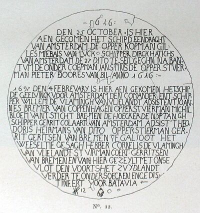
No. 12. Opschrift op den schotel, door Willem De Vlamingh op het Zuidland achtergelaten (Inscription on the dish, left by Willem De Vlamingh at the Southland), 1697.
{Page 85}
And since it is our intention, in order to let Your Worships have the more information and satisfaction touching this voyage, to dispatch to the Netherlands again in the last return-ships sailing from here, the ex-leader of the expedition, Skipper Willem de Vlaming Senior, together with his upper-steersman Michiel Blom, they having not yet returned from Bengal with their ships Geelvinck and Nijptang, but being expected every day, therefore we shall not trouble Your Worships with further particulars, but would beg leave to refer you to their verbal reports for ampler information touching their experiences in the said expedition...
In the Castle of Batavia, on the last day of November, 1697.
B.
Journal kept by Skipper WILLEM DE VLAMINGH on his voyage with the ships de Geelvinck, Nijptang and T'Weseltje via Trestan da Cunha, the Cape, the islands of Peter and Paul, and the South-land to Batavia, begun on May 3, 1696, and ended March 20, 1697. [*]
[* This is the only journal of this voyage that I have found in the Old Colonial Archives at the Hague. I have not printed it here--so far as the South-land is concerned, it wil be found printed in LEUPE, Zuidland, pp. 153-184--for two reasons: 1st because it differs only slightly from a journal of the voyage printed in 1701, of which MAJOR, Terra Australis, pp 120-133 gives a translation; and 2nd, because the two charts immediately following in the text (Nos. 13 and 14) give an excellent survey of the results of this voyage of discovery.]
{Page 86}
C.
Chart of the South-land, made and surveyed by Willem De Vlamingh in 1696-1697. [*]
[* This chart was not made on the voyage, but is the work of ISAAC DE GRAAFF, cartographer to the E.I.C. from 1690 to 1714.]
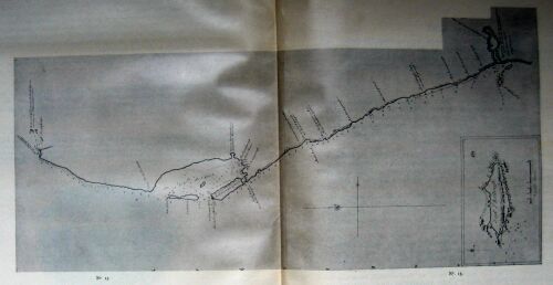
No. 13. Kaart van het Zuidland, bezeild door Willem De Vlamingh. in 1696-1697 door ISAAC DE GRAAFF (Chart of the South-land, made and surveyed by Willem De Vlamingh in 1696-1697)
{Page 87}
D.
Chart of the Malay Archipelago, the north- and west-coasts of Australia, etc. [*]
[* This chart is likewise the work of ISAAC DE GRAAFF (1690-1714). It gives a survey of the results of De Vlamingh's voyage, and may also do duty as a general record of the Dutch discoveries on the north- and west-coast of Australia in the 17th century. The dotted (uncertain) line on the N.W. coast is supplemented by the chart of Van der Wall's discovery in 1678 (No. 11).]
(See folding Chart, marked No. 14.)
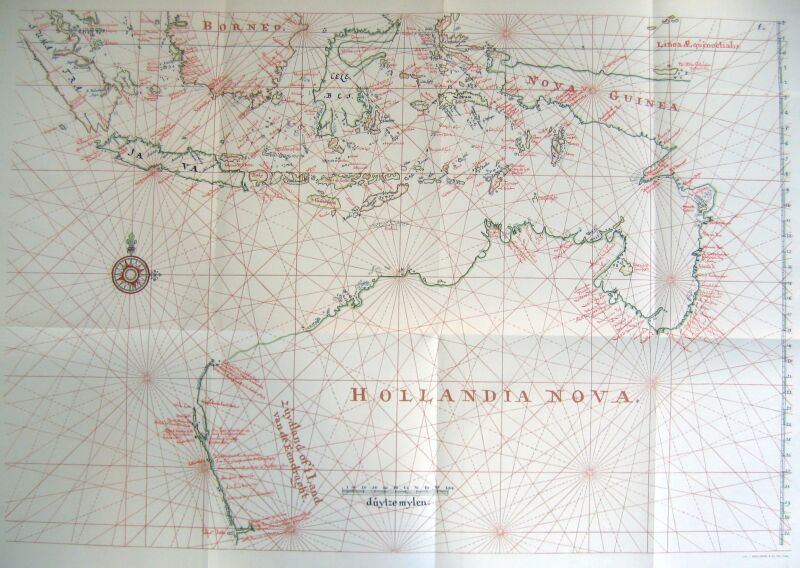
No. 14. Uitslaande kaart van den Maleischen Archipel, de Noord- en West-kusten van Australië door ISAAC DE GRAAFF (Folding chart of the Malay Archipelago, the North- and West-coast of Australia) 1690-1714
XXXIII. (1705). FURTHER DISCOVERY OF THE NORTH-COAST OF AUSTRALIA BY THE SHIPS VOSSENBOSCH, COMMANDED BY MAARTEN VAN DELFT, DE WAIJER UNDER ANDRIES ROOSEBOOM, OF HAMBURG, AND NIEUW-HOLLAND OR NOVA-HOLLANDIA, COMMANDED BY PIETER HENDRIKSZOON, OF HAMBURG.
A.
Instructions (by the G.-G. and Counc., dated January 20, 1705) for the officers of the Frigate de Geelvink, along with the Pinnace de Kraanvogel and the Patchiallang Nova Guinea, destined to set out for the outside coast of the said Nova Guinea; as also for the Flute Vossenbos, together with the Pinnace de Doradus [*] and the Patchiallang Nieuw Holland, having destination for the bay of Hollandia Nova.
[* Afterwards replaced by the pinnace de Waijer.]
[Various] considerations have determined us to dispatch you from here on a cruise, in such fashion that the frigate Geelvinck together with the pinnace Craanvogel and the patchiallang Nova Guinea, mentioned in the heading of the present, will first run from here directly for Banda...and from Banda continue their voyage to the coast of Nova Guinea.
In the same manner we annex sailing instructions for the officers of the ship Vossenbosch, which together with the pinnace de Doratus and the patchiallang Nieuw Holland, likewise above mentioned, will first run for our Castle of Concordia in Timor, and then continue her voyage to Hollandia Nova, in such fashion as you will for your guidance find further amplified below...
You will in the first place have diligently to observe, whether there is anywhere a passage from the outside to the inside, and this not only as regards Nova Guinea, but also as concerns Hollandia Nova, so that these orders...will have to be acted up to not only by the officers of the Geelvinck, but also by those of the Vossenbosch; and you should take special care, in case you should find such real or seeming passage, not to run too far into it, lest you should be carried away by currents in the same, and run the risk of accidents; on which account the examination of such passages should nowise be undertaken by the frigate or by the flute, but only by a pinnace or patchiallang; never to any farther distance than the experienced sailors in the same shall deem advisable to enable a safe return out of the said passages, and in no case so far as to get out of anchoring depth...
{Page 88}
And furthermore, as sailing instructions for the officers of the flute [Vossenbosch], over and above that which should be applicable to them in the instructions given up to now, it has been resolved to enjoin them that having reached Timor...they will thence set sail from the north-eastern extremity of the said island, and shape their course south-eastward as far as 11° S. Lat. and 148½° Longitude, whence on an eastward course they will run in sight of Van Diemensland in Hollandia Nova, which point is said to consist altogether of islands, a matter that will thus be cleared up. From there this coast will have to be further followed to eastward as far as Aarnemsland and the Drooge eyland, which will have to be skirted and surveyed both on the inside and outside; next, the coast aforesaid will have to be followed as far as Van der Lijns eiland, which you will examine in the same way as you have done the Drooge eyland. You will then continue your voyage as far as Lemmens bogt and Abel Tasmans baay and Waterplaats, and from there run for Cape Van Diemen, which having rounded you will follow the coast of Carpentaria in a northward direction along Sweeris, Van der Ljns, Van Diemens and Staten rivers, until you have passed the Nassauw river, which according to the chart has its mouth beset with numerous sand-banks and shallows. Next, running past Cape Keerweer, the Carpentier river, the Hooge eyland and the Groote vuyle imbocht, together with the Oranjen river, and having rounded the great projecting point of the Meeuen river, you will run along the bay of Keerweer then following, always along the coast in a westerly direction, past the Doodslagers revier, de Waterplaets, until you have got beyond Goening Apy, Moordenaers revier and the Wesels eyland, and also beyond Speelmans river and Rijkloffs bays, after which you will make the point of Ony, whence you will cross over along Keffing in Banda, as has already been noted in passing...
The commander of the flute Vossenbosch aforesaid, in case the whole bight of Nova Hollandia, owing to adverse weather or defects of the ship, cannot be made according to these our instructions so as to enable her to be back in Banda at the end of September, will be empowered with the advice of the ship's council, from the Drooge eylant aforesaid to cross over to the Meeuen river, situated nearly N.W. and S.E. of each other, and thereby to shorten the voyage to that extent, always provided that no other means can be found...
If in...Nova Hollandia you should happen to come upon unknown Indians, of whom you might without violence or risk, and of their own free will, bring two or three with you hither, such men might possibly prove of great use in subsequent voyages, but this point we leave to your own judgment and discretion, as you shall find circumstances to shape themselves.
Victuals and provisions for all your ships for the space of 10 months have been ordered on board here...
In the Castle of Batavia, January 20, 1705.
{Page 89}
B.
A Report and account [dated October 6, 1705] of what has been discovered and found noteworthy in the voyage of the flute Fossenbosch, the pinnace d'Waijer and the patsjallang Nova Hollandia, dispatched from Batavia to Hollandia Nova aforesaid by way of Timor, by the Supreme Government of India, A.D. 1705; as collected and digested from the written journals [*] and verbal narratives of the officers returned, by the Councillors-Extraordinary HENRICK SWAARDECROOM and CORNELIS CHASTELIJN, commissioned for this purpose; the whole to serve as a report to be delivered to His Worship Governor-General JOAN VAN HOORN and the Lords Councillors of India. [**]
[* I have not found these journals.]
[* I have not printed this Report, 1st because it has been edited by LEUPE in Bijdragen tot de taal-, land- en volkenkunde van Nederlandsck-Indie, Nieuwe Volgreeks, I, pp. 193-201; 2nd because an English translation of it is given in MAJOR, Terra Australis, pp. 165-173; 3rd because chart No. 15 excellently represents the results of this voyage. The reproduction being on a reduced scale, some names of places are not so clearly legible as could be wished, but they will be found referred to in my Introduction.]
C.
Chart of Hollandia Nova, further discovered A.D. 1705 by the ships Vossenbosch, de Wajer and Nova Hollandia, which left Timor on March 2 [*].
[* On July 12 the ships discontinued their voyage of discovery, and returned to Banda, where they arrived about a fortnight later.]
{Page 90}
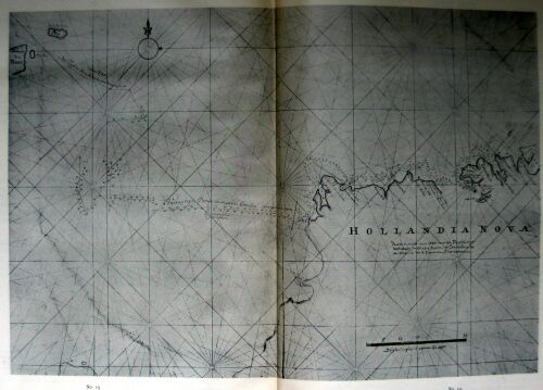
No. 15. Kaart van (Chart of) Hollandia Nova, nader ontdekt anno 1705 door (more exactly discovered by) de Vossenbosch, de Waijer en de Nova Hollandia
XXXIV. (1721-1722). EXPLORATORY VOYAGE BY ORDER OF THE WEST-INDIA COMPANY "TO THE UNKNOWN PART OF THE WORLD, SITUATED IN THE SOUTH SEA TO WESTWARD OF AMERICA", BY THE SHIPS AREND AND TIENHOVEN, AND THE AFRICAN GALLEY, COMMANDED BY MR. JACOB ROGGEVEEN, JAN KOSTER (IN THE SHIP AREND), CORNELIS BOUMAN (IN THE SHIP TIENHOVEN), AND ROELOF ROSENDAAL (IN THE AFRICAN GALLEY).
Although the history of this voyage, begun from the Texel on August 1, 1721, does not form part of the subject here treated, I mention it in passing merely to note that among other places the ships touched at Paasch-eiland, and at the Paumatos and Samoa island-groups, and reached Java along the north-coast of New Guinea. The journal of this voyage is preserved in the Hague State Archives and has been edited by the Zealand Genootschap der Wetenschappen. (Middelburg, 1838).
{Page 91}
XXXV. (1727). THE SHIP ZEEWIJK, COMMANDED BY JAN STEIJNS, LOST ON THE TORTELDUIF ROCK.
A.
Letter of the G.-G. and Counc. to the Managers of the E.I.C., October 31, 1728.
...On the 26th of April there arrived here quite unexpectedly with the patchiallang de Veerman a note from the ex-skipper and the subcargo of the Zealand ship Zeewijk, Jan Steijns and Jan Nebbens, written from Sunda Strait...informing us that the said ship, after sailing from the Cape of Good Hope [*] on April 21 [1727], had on June 9 following run aground on the reef situated before the islands called Fredrik Houtmans Abriolhos near the South-land in 29° S.L., also known as the Tortelduijf islands; that favoured by good weather the men had saved from the wreck all kinds of necessaries, and with the loosened woodwork had constructed a kind of vessel, with which they had set out from there on the 26th of March, and arrived in the aforesaid strait on the 21st of April last...
[* The ship had sailed from the Netherlands, November 7, 1726.]
[We] have found...not only that the ex-skipper Jan Steijns has, against his positive instructions and against the protests of the steersmen, too recklessly sailed near the South-land, and thereby been the cause of this disaster, but also that he has attempted to impose upon his superiors by falsified journals, hoping thereby, if possible, to conceal his grievous mistake...
The situation of the islands on whose outermost reef the ship Zeewijk has run aground, is shown by the annexed small chart [*]. They lie out of sight of the South-land, and are partly overgrown with brushwood, edible vegetables, etc...here have been discovered not only a number of wells dug by human hands, but also certain vestiges of a Dutch ship, presumably also lost on the reef aforesaid...
[* To the Netherlands were sent "two charts of the situation of the Reef, and of the islands aforementioned" (charts 16 and 17 below).]
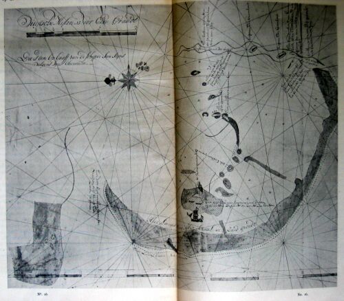
No. 16. Kaarte betreffende de schipbreuk der Zeewijk (Chart, concerning the shipwreck of the Zeewijk) 1727.
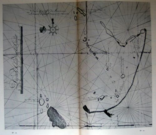
No. 17. Kaarte betreffende de schipbreuk der Zeewijk (Chart, concerning the shipwreck of the Zeewijk) 1727.
B.
Journal or daily register, kept [by the second steersman Adriaan (Van) de Graeff] on board the sho Zeewijk; after the miscarriage of the same, on the wreck stuck fast on a rocky reef near the unknown Southland; and a few days after, in the island [*].
[* This journal is of no interest for our purpose, and I mention it pro memoria only. The charts sufficiently record the results.]
C.
Chart drawn by JAN STEIJNS. (No. 16).
D.
Chart drawn by ADRIAAN (VAN) DE GRAAF [*]. (No. 17.)
[* Later in the XVIII century (inter alia in 1755 and 1765) the West-coast of Australia was again visited by Dutch ships, but what we know about this point is of no significance.]
{Page 92}
XXXVI. (1756). EXPLORATORY VOYAGE OF THE SHIPS RIJDER. AND BUIS, COMMANDED BY LIEUTENANT JEAN ETIENNE GONZAL AND FIRST LAVIENNE LODEWIJK VAN ASSCHENS, TO THE GULF OF CARPENTARIA.
Report of the "Master Cartographer" at Batavia, GERRIT DE HAAN, to the G.-G., and Counc. September 30, 1756.
Pursuant to Your Honourable Worships' highly honoured orders, the undersigned has the honour to submit to Your Honourable Worships a report concerning the voyage made by the small bark-ships de Rijder and de Buijs to the South-land, so far as the same has been touched at by them, as Your Honourable Worships may be pleased further to gather from the annexed charts [*].
[* I have not found either these charts or any journals of this expedition.]
On the 8th of February, 1756 the two ships set sail together from this roadstead...
On March 26 they were overtaken by a violent storm off the Banda islands, so that they got separated, and the ship Buijs, finding it impossible to stand out to sea, entered the port of Banda on March 28; the ship Rijder held out with fore- and mizen-sails struck until the weather got better, and not knowing that the ship Buys had returned to port, continued her voyage. On April 4 those on board the ship Rijder sighted Cape Falso in Lat. 7° 54' S., in 5 and 4½ fathom; they then shaped their course to the S.E. and afterwards to the S.S.E., until on April 10 they saw the high land of Carpentaria, known by the name of hoog Eijland, near which they found an island not known to the chart, to which island they gave the name of Rijders Eijland. From the hooge Eyland a reef runs out to sea a distance of nearly three miles coming close to the Rijders Eyland...They then shaped their course along the land in order to get into the bay, in depths Of 8, 7, 7½, 6½ fathom sandy bottom, at which last depth they came to anchor on April the 16th, where they estimated themselves to be about two miles off shore. On the 17th do. they went ashore with the boat for the first time in order to ascertain the nature of the coast. On landing they found a number of cabins constructed of the bark of trees; they also saw a man who fled into the wood at their approach, and a small prow or species of vessel also made of bark, together with some fishing-tackle and a kind of assagays made of branches of trees, from 4 to 9 feet long, tipped at one end with a small piece of bone ground to a sharp point. The fishing-lines seemed to be twisted out of fibrous bark, and, instead of hooks, had pointed claws of beasts fastened to them. The land was overgrown with tall grass, and they saw a number of fine dells or valleys, through which flowed various small rills of fresh water; the trees were very tall and straight, of regular growth and of different kinds, some of which would, as they presumed, furnish excellent timber for ships' masts, yards, etc. The soil was very rich, and on the whole the country looked very promising. They remained there, making various landings, and taking in firewood and water, till the 26th of April, when they put to sea again...shaping their course E.N.E. close to the wind in depths Of 5, 6 or 7 fathom, following the trend of the coast till they had got into 10° 30' S. Lat., where they cast anchor on April 28, in order to explore the land also in this latitude. They found nothing worth mentioning, however, {Page 93} except a few more cabins or huts of the kind before described, the inmates of which took to the wood as soon as our men appeared. They dragged the boat on the {Page 94} beach here, and repaired the same, remaining there till the 13th of May, waiting for the ship de Buys. On that day they resolved to continue their voyage, shaping their course along the land as high as they could in order to keep the same alongside; but they lost sight of the land all the same, and became aware that the said land lay at least one degree more to southward than the chart had led them to believe. On the 24th of May they again sighted the land in 12° 18' S. Lat.; it showed as a very low-lying coast, whose trend they followed close inshore. In Lat. 12° 26' South they cast anchor in 10 fathom good anchoring-ground. As they were lying at anchor at about 1 or 1½ mile's distance from the shore, they saw two of the prows above described paddle up to the ship, each of them containing two men, who, when they had got near the ship, by signs and cries began to signify to our men that they wished them to come ashore. The following day, being the 26th of May, our men went ashore at daybreak, and on landing found several persons there, who, however, all took to flight directly. They also saw two dogs, not unlike so-called Bengal jackals. The persons who had fled, shortly after returned to them, when they found them armed with the assagays above described. They were accompanied by a number of females who had their privities covered with a kind of small mats. The natives then all of them sat down on the beach near our men, who made signs to them that they were seeking fresh water; upon which the natives got up and signified to our men their willingness to show them the places where water was obtainable. Nor were our men deceived, for after walking on along the beach for some time, they were conducted to a pleasant valley with fine trees such as those above described. This seemed to be the dwelling-place of the natives, for our men saw here more women and children and also a number of primitive dwellings, merely consisting of sheltered places under the trees partly covered in with bark. The water which they found here, welled up out of the earth in pits dug by human hands. After having inspected the whole place, they went back to the beach, where they found the two prows in which the natives had previously approached the ship. As our men were seated on the beach, nineteen natives came up to them, all of them with bodies daubed over with red; when the said natives were by our men treated to some arrack with sugar, they began to make merry and even struck up a kind of chant, at the conclusion of which they retired to the wood again.
In the morning of the 27th our men went ashore again for the purpose of attempting to get hold of one or two natives, but did not succeed in doing so that day, because they landed too late to lure the natives to the beach. Early in the morning of the 28th they again landed in order to execute their plan; on their arrival the natives came up to them dancing and singing, sat down close to them, laid aside their so-called assagays or weapons, and again enjoyed the liquor with which our men plied them. While they were thus making merry, our men seized hold of two of them [*], upon which the others jumped to their feet, snatched up their assagays and began to throw them at our people without, however, wounding any one; except that the ship's clerk, who in flying tried to seize one of the natives round the body, was in the scuffle slightly wounded in the hand; upon this, our men fired a volley, wounding one of the natives, who thereupon all of them fled into the bush. Our people then tried to drag to the boat the two men they had got hold of, but as they were tying their {Page 95} arms and legs together, one of them by frantic biting and tearing contrived to get loose and effect his escape. Shortly after upwards of fifty natives again made their appearance, throwing assagays, but they also took to their heels, when our people let off another volley of musketry, after which our men succeeded in carrying off their one prisoner to the boat.
[* A sorry return for kindness received!]
{Page 96}
On the 29th of May, the wind being S.E. and S.E. by E. with a top-gallant gale, they put to sea again, running S.S.W. close by the wind in from 10 to 11 fathom good anchoring-ground. At noon they found their latitude to be 12° 31' South, and dropped anchor in 10 fathom good anchoring-ground, at about 1 or 1½ mile's distance from the land, their compasses showing 3° 49' north-easterly variation.
On the 30th of May, as they were lying at anchor, two small prows came to within half a mile of the ship and then paddled back to shore.
On the 31st of May, the wind being East and E.S.E., with a top-gallant gale, they set sail close to the wind on a southerly course. At noon they took the latitude of 12° 44' South, having passed depths of 10 and 10½ fathom. At sunset the countercurrent forced them to drop anchor before the Mosselbaaij.
On the 1st of June, the wind being E.S.E. and S.E. by E. with a weak top-gallant gale, they set sail over depths of 10½, 11, 12 and latterly 10½ fathom again, good anchoring ground, upon which they dropped anchor in the forenoon. At noon it fell a calm, and they took the latitude of 12° 51' South, the compasses showing 3° 3' north-easterly variation.
In the morning of June 2 the wind varied between East, E.S.E., and S.E., and then went round to S.W. by S.; they sent the boat ashore in search of fresh water, since in the latitude they had now reached the chart showed a fresh-water river. When the boat returned alongside, they were informed that there was an excellent watering-place close by, where the water came rushing down the rocks, and also a fine inland lake, near which the men had seen a great number of birds of various kinds, together with certain foot-prints of large animals. In the drawing or chart this spot has been named Rijders waterplaats situated in 12° 57' S. Lat.
On the 3rd of June, the wind blowing from the East to E.S.E. with a fresh breeze, they set sail for the watering-place aforesaid in 11, 10, 11½, 9½, 9 and 8 fathom, good anchoring ground and muddy sand, in which they dropped anchor at two glasses in the afternoon.
From the 4th to the 12th of June they overhauled the ship, took in water and firewood, and repaired the boat. During this time no natives were seen by them.
On the 13th of June, the wind being E.S.E. and S.E. by E. with a weak top-gallant gale, they put to sea again, following the trend of the coast on a course between W.S.W. and S. by E...over depths of 8, 8½, 9, and 10 fathom, good anchoring-ground with pebbles and small shells. At noon they took the latitude of 12° 2' South, and in the afternoon the head-current forced them to come to anchor.
On the 14th of June, the wind varying between S.E. by E. and South, they set sail running close by the wind on a southerly and S. by E. course in 9, 9½, 10 and 11 fathom sandy bottom. At noon their estimated course and distance performed since sunrise were S.S.W. half a point westerly, and 2½ miles, the latitude taken being 13° 8' South. In the afternoon the wind was S.S.W. by W. with a weak breeze and occasional calms; they sounded from 11 to 8 fathom sandy bottom with black spots and pebbles; at the depth last mentioned they came to anchor at the first glass of the dog-watch, slightly to southward of de Rijdershoek, about 1 or 1¼ mile off shore, the compasses showing 3° 45' north-easterly variation.