DOCUMENTS. (continued 2)
Reading edition
In the evening we cast anchor in three fathom about 3 miles from the land, having sailed 13 miles this day.
In the morning of the 27th the wind was W.N.W. with a stiff breeze, course held S.E. by S. and S.E., on which we sailed 7 miles, and afterwards E.S.E. 5 miles, in 5½, 5 and 3 fathom; in the evening we came to anchor in 6½ fathom, 3½ miles from the land; a quarter of a mile farther to landward we saw a sandbank, on which the Aernem struck but got off again, for which God be praised.
On the 28th we set sail again, with a N.W. wind, on an eastern course towards the land, in various depths, such as 7, 9, 12, 4 and 5½ fathom; at noon we were in 9° 6' S. Lat., having sailed 5 miles; from noon till the evening we ran on an E. by S. course a distance Of 4 miles in 18, 12, 9, 7, 5 and 2 fathom, after which we cast anchor, and sent out the pinnace to take soundings; the water being found to become deeper nearer the coast, we again weighed anchor and sailed to the land, casting anchor finally in 4 fathom three miles from the coast.
In the morning of the 29th the wind was N.N.E. with fine weather; in the forenoon it was deemed advisable to send off the boat of the Pera with thirteen men and the steersman of the Aernem and victualled for four days, in order to take soundings and skirt the land, which extended E.N.E., for a distance of 7 or 8 miles.
On the 30th the wind was N. with good weather, so that we also sent out the pinnace of the Aernem in order to take soundings in various directions 2 or 3 miles from the yachts; at low water we saw various sandbanks and reefs lying dry, to wit E.S.E., S.S.W. and W.; in the afternoon the pinnace of the Aernem returned on board, having found shallows everywhere at 2 miles' distance. Towards the evening the boat of the Pera also returned, when we heard from the steersman that they had been E. by S. and E.S.E. of the yachts, at about 8 miles' distance, where they had found very shallow water, no more than 7, 8, 9 and 10 feet, which extended a mile or more, and was succeeded by depths Of 2, 2½, 3, 5 and 7 fathom; they had found the land to extend E. and E. by N., and to be very low-lying and muddy, and overgrown with low brushwood and wild trees.
On the 31st the wind was N.N.E. with rain. In the afternoon I rowed with the two pinnaces to one of the reefs in order to examine the state of things between the yachts and the land, which space had fallen dry at low tide; in the afternoon the skipper of the Pera also got orders to row to the land with the boat duly manned and armed, in order to ascertain whether anything could be done for the service of our Masters, and to attempt to get a parley with the inhabitants and to get hold of one or two of them, if practicable; very late in the evening the boat returned on board, and we were informed by the skipper that, although it was high water, they could not come nearer than to a pistol-shot's distance from the land owing to the shallow water and the soft mud; they also reported the land to be low-lying and half-submerged, overgrown with brushwood and wild trees.
{Page 34}
NOTE.
(The Drooge Bocht, where we were compelled to leave the western extremity of Nova Guinea is in 9 degrees 20 minutes S. Lat.)
After hearing the aforesaid reports touching the little depths sounded to eastward, we are sufficiently assured that it will prove impossible any longer to follow the coastline which we have so long skirted in an eastward direction, and that we shall, to our great regret, be compelled to return the same way we have come, seeing that we have been caught in the shallows as in a trap; for this purpose we shall have to tack about and take advantage of the ebb, and as soon as we get into deeper water, to run south to the sixteenth degree or even farther, if it shall be found advisable; then turn the ships' heads to the north along the coast of Nova Guinea, according to our previous resolution taken on the 6th of March last; as mentioned before, we were here in 9° 6' S. Lat., about 125 miles east of Aru, and according to the chart we had with us and the estimation of the skippers and steersmen, no more than 2 miles from Nova Guinea, so that the space between us and Nova Guinea seems to be a bight to which on account of its shallows we have given the name of drooge bocht [*] [shallow bight] in the new chart; to the land which we had run along up to now, we have by resolution given the name of 't Westeinde van Nova Guinea (Western extremity of N. G.), seeing that we have in reality found the land to be an unbroken coast, which in the chart is marked as islands, such as Ceram and the Papues, owing to misunderstanding and untrustworthy information.
[* Entrance of Torres Strait.]
APRIL.
On the first the wind was W. by S. with good weather; we weighed anchor and drifted with the ebb running from the N.E. when we had run 1½ mile with the tide to the S.W., we came to anchor again in 6 fathom.
On the second, the wind being W. by N., we tried to tack about to the W. with the ebb-tide in 4, 5 and 6 fathom; we had variable winds the whole day; towards the evening we cast anchor in 4 fathom three miles from the land, having this day progressed 4 miles to the W. and W. by N.
On the third we set sail again at daybreak, the wind being N., course kept W.N.W. in 7, 2, and 2½ fathom, the water in these parts being of greatly varying depths, so that we had to keep sounding continually; in the afternoon we dropped anchor in 4 fathom, having drifted 2½, miles with the ebb-tide.
On the 4th, the wind being N.E. by N., we set sail again with good weather: in the afternoon we ran on with the tide and cast anchor in 7 fathom, having lost sight of the land, and sailed 8 miles W. and W. by N.
NOTE.
Here we managed with extreme difficulty and great peril to get again out of the shallows aforesaid, into which we had sailed as into a trap, between them and the land, for which happy deliverance God be praised; the shallows extend South and North, from 4 to 9 miles from the mainland, and are 10 miles in length from East to West.
{Page 35}
On the fifth we set sail again at daybreak, the wind being E.N.E., on courses varying between S.W. and S., by which we got into deeper water, between 14 and 26 fathom, and sailed 18 miles in the last 24 hours.
On the sixth the wind was S.W. with rain, course held S.E.; at night we were in Lat. 9° 45', having sailed 11 miles to the E.S.E. in the last 24 hours.
On the 7th, the wind being S.S.E., we ran on an Eastern course in 15 or 16 fathom, and sailed 4 miles till the evening; at nightfall we went over to S.E., and cast anchor in 4 fathom, but as the yacht was veering round, we got into 2 fathom, having sailed three miles E.S.E. during the night.
In the morning of the 8th we clearly saw several stones lying on the sea-bottom, without perceiving any change in the water in which we had sounded 26 fathom; so that the land here, which we did not see, is highly dangerous to touch at, but through God's providence the yachts did not get aground here; at noon we set sail, being in 10° 15' S. Lat., the wind being W. by S. and afterwards variable; we sailed S.S.W. till the next morning, in 10 and 10½ fathom, and covered 6 miles.
On the 9th the wind was N. with rain, course held S.E.; at night the wind went round to S.E.; we therefore came to anchor in 11 fathom, having sailed 5 miles this day.
In the morning of the 10th the wind was E.N.E., course held S.E. in 9, 10, and 11 fathom; at night the wind blew from the S.E., upon which we cast anchor, having sailed 5 miles this day.
On the 11th the wind was E. by N. with a fair breeze, course kept S.S.E.; at noon we were in 11° 30'; the whole of this day and night we tried to get south with variable winds and on different courses, and sailed 22 miles in the last 24 hours; course kept S.E.
In the morning of the 12th the wind was S.E. with good weather; at sunrise we saw the land of Nova Guinea [*], showing itself as a low-lying coast without hills or mountains; we were then in 13½ fathom, clayey bottom; course held S.S.W.; at noon we were in Lat. 11° 45' South, having sailed 10 miles on a S.E. course in the last 24 hours.
[* York Peninsula.]
In the morning of the 13th the wind was S.E. by E. and we were in 24 fathom; we still saw the land aforementioned and found it to be of the same shape as before; course held S.W.; at noon we were in 12° 53'; for the rest of day and night we tried to get south with the winds aforesaid and on varying courses, having sailed 22 miles in the last 24 hours; course kept S.W.
On the 14th the wind was E. by S., course held S. by E. along the land in 11, 12, 13, and 14 fathom; at noon we were in Lat. 13° 47', the land being no longer in sight. The rest of the day and the whole night we tried to get the land alongside with divers winds and on varying courses in 7, 6, 6, 4, 3, and 2½ fathom; towards daybreak we were so near the land that one might have recognised persons on shore.
In the morning of the 15th the wind blew hard from the East; course held S. by E. in 3 and 2½ fathom along a sandbank, situated about one mile from the mainland; at noon we were in 14° 36. The land which we have hitherto seen and followed, extends S. and N.; it is low-lying and without variety, having a fine sandy beach in various places. In the afternoon we dropped anchor owing to the calm, having sailed {Page 36} 11 miles South. Great volumes of smoke becoming visible on the land, the subcargo [*] got orders to land with the two pinnaces, duly manned and armed, and was specially enjoined to use his utmost endeavours for the advantage of Our Masters; when the pinnaces returned at nightfall, the subcargo reported that the pinnaces could get no farther than a stone's throw from the land, owing to the muddy bottom into which the men sunk to their waists, but that they had in various places seen blacks emerging from the wood, while others lay hid in the coppice; they therefore sent a man ashore with some pieces of iron and strings of beads tied to a stick, in order to attract the blacks; but as nothing could be effected and the night was coming on, they had been forced to return to the yachts.
[* Pieter Lintiens. (Summary).]
In the morning of the 16th, being Easter-day, the wind was East; we set sail, holding our course S. by E.; at noon we were in 14° 56'; in the evening we came to anchor in 5 ½fathom, having sailed 10½ miles, course kept South.
In the morning of the 17th the wind was S. by W., with rain and the tide setting to the south; at noon the wind went round to East, so that we made sail, course held S. by W., along the land in 4½ fathom; towards the evening, it fell a calm, so that we dropped anchor with the ebb, after which I went ashore myself with the two pinnaces duly provided with men and arms; we went a considerable distance into the interior, which we found to be a flat, fine country with few trees, and a good soil for planting and sowing, but so far as we could observe utterly destitute of fresh water. Nor did we see any human beings or even signs of them; near the strand the coast was sandy with a fine beach and plenty of excellent fish.
In the morning of the 18th the wind was E.N.E., course held S. by W. along the land; about noon, as we saw persons on the beach, we cast anchor in 3½ fathom clayey bottom; the skipper of the Pera got orders to row to land with the two pinnaces, duly provided for defence; in the afternoon when the pinnaces returned, we were informed by the skipper that as soon as he had landed with his men, a large number of blacks, some of them armed and others unarmed, had made up to them; these blacks showed no fear and were so bold, as to touch the muskets of our men and to try to take the same off their shoulders, while they wanted to have whatever they could make use of; our men accordingly diverted their attention by showing them iron and beads, and espying vantage, seized one of the blacks by a string which he wore round his neck, and carried him off to the pinnace; the blacks who remained on the beach, set up dreadful howls and made violent gestures, but the others who kept concealed in the wood remained there. These natives are coal-black, with lean bodies and stark naked, having twisted baskets or nets round their heads; in hair and figure they are like the blacks of the Coromandel coast, but they seem to be less cunning, bold and evil-natured than the blacks at the western extremity of Nova Guinea; their weapons, of which we bring specimens along with us, are less deadly than those we have seen used by other blacks; the weapons in use with them are assagays, shields, clubs and sticks about half a fathom in length; as regards their customs and policy and the nature of the country, Your Worships will in time be able to get information from the black man we have got hold of, to whom I would beg leave to refer you...
On the 19th, the wind being S.E., we remained at anchor, and since the yachts were very poorly provided with firewood, the skipper of the Pera went ashore with the two pinnaces duly manned and armed; when the men were engaged in cutting wood, {Page 37} a large number of blacks upwards of 200 came upon them, and tried every means to surprise and overcome them, so that our men were compelled to fire two shots, upon which the blacks fled, one of their number having been hit and having fallen; our men then proceeded somewhat farther up the country, where they found several weapons, of which they took some along with them by way of curiosities. During their march they observed in various places great quantities of divers human bones, from which it may be safely concluded that the blacks along the coast of Nova Guinea are man-eaters who do not spare each other when driven by hunger.
On the 20th, the wind being S.E., we set sail on a S.S.W. course; at noon we came to anchor with the ebb-tide running from the South, in 3½ fathom clayey bottom, and ordered the skipper to go ashore with the two pinnaces, duly provided for defence, and diligently inquire into the state of things on shore, so far as time and place should allow; when he returned in the evening, he informed us that the surf had prevented them from getting near the strand, so that there could be not question of landing.
In the morning of the 21st, the wind being S.E., we set sail; course held S.S.W. along the land; at noon we were in 15° 38'; in the evening we came to anchor with the ebb in 3½ fathom.
In the morning of the 22nd the wind was E.N.E., course held South; at noon we were in 16° 4'; the wind being W. by N. we dropped anchor towards the evening in 2½ fathom, about one mile from the land.
On the 23rd the wind was N.N.E., with a stiff breeze, so that we set sail on a S.S.W. course along the land in 3½, 3, 2½ and 2 fathom, clayey bottom; at noon we were in 16° 32'; for the rest of the day we tried to get south with variable winds, and towards the evening came to anchor in 3 fathom close inshore.
On the 24th the wind was E. by S., course held S.S.W. along the land in 2½, 3½ and 4½ fathom, clayey bottom; at noon we were in 17° 8'. This same day the council having been convened, I submitted to them the question whether it would be advisable to run further south, and after various opinions had been expressed, it was agreed that this would involve divers difficulties, and that the idea had better be given up: we might get into a vast bay, and it is evident that in these regions in the east-monsoon north-winds prevail, just as north (?) of the equator south-winds prevail in the said monsoon: we should thus fall on a lee-shore; for all which reasons, and in order to act for the best advantage of the Lords Managers, it has been resolved and determined to turn back, and follow the coast of Nova Guinea so long to northward as shall be found practicable; to touch at divers places which shall be examined with the utmost care, and finally to turn our course from there to Aru and Quey...it was furthermore proposed by me and ultimately approved of by the council, to give 10 pieces of eight to the boatmen for every black they shall get hold of on shore, and carry off to the yachts, to the end that the men may use greater care and diligence in this matter, and Our Masters may reap benefit from the capture of the blacks, which may afterwards redound to certain advantage.
On the 25th the skipper of the Pera got orders to go ashore with the two pinnaces well-manned and armed, in order to make special search for fresh water, with which we are very poorly provided by this time; about noon the skipper having returned, informed us that he had caused pits to be dug in various places on the coast, but had found no fresh water. Item that on the strand they had seen 7 small huts made of dry hay, and also 7 or 8 blacks, who refused to hold parley with them. In the afternoon I went up a salt river for the space of about half a mile with the two pinnaces; {Page 38} we then marched a considerable distance into the interior, which we found to be submerged in many places, thus somewhat resembling Waterland in Holland, from which it may be concluded that there must be large lakes farther inland; we also saw divers footprints of men and of large dogs, running from the south to the north; and since by resolution it has been determined to begin the return-voyage at this point, we have, in default of stone caused a wooden tablet to be nailed to a tree, the said tablet having the following words carved into it: "Anno 1623 den 24n April sijn hier aen gecomen twee jachten wegen de Hooge Mogende Heeren Staten Genl."
[A.D. 1623, on the 24th of April there arrived here two yachts dispatched by their High Mightinesses the States-General]. We have accordingly named the river aforesaid Staten revier in the new chart. (The Staten Revier is in 17 degrees 8 minutes.)
On the 26th, seeing that there was no fresh water here, of which we stood in great need, that we could hold no parley with the natives, and that nothing of importance could be effected, we set sail again, the wind being E.N.E., with a stiff breeze, course held N. along the land; at noon we were in Lat. 16° 44'; at night we came to anchor in 4 fathom close inshore.
NOTE
That the yacht Aernem, owing to bad sailing, and to the small liking and desire which the skipper and the steersman have shown towards the voyage, has on various occasions and at different times been the cause of serious delay, seeing that the Pera (which had sprung a bad leak and had to be kept above water by more than 8000 strokes of the pump every 24 hours) was every day obliged to seek and follow the Aernem for one, two or even more miles to leeward.
(The yacht Aernem left the Pera.)
On the 27th, the wind being E. by S. with good weather, the skipper of the Pera rowed ashore with the two pinnaces duly provided for defence, in order to seek fresh water, but when he had caused several pits to be dug, no water was found; we therefore set sail forthwith, holding a S.E. by E. course along the land; at noon we were in Lat. 16° 30', and with a W. by N. wind made for the land, sailing with our foresail only fully two hours before sunset, in order to wait for the Aernem which was a howitzer's shot astern of us; in the evening, having come to anchor in 3½ fathom 1½ mile from the land, we hung out a lantern, that the Aernem might keep clear of us in dropping anchor, but this proved to be useless, for on purpose and with malice prepense she away from us against her instructions and our resolution, and seems to have set her course for Aru (to have a good time of it there), but we shall learn in time whether she has managed to reach it.
In the morning of the 28th the wind was E. by S. and the weather very fine; the skipper once more went ashore with the pinnace in order to seek water, but when several pits had been dug in the sand, they found none; we therefore set sail again on a N.E. by N. course along the land in 2, 3, 4 and 5 fathom, but when we had run a distance Of 2½ Miles, a violent landwind drove us off the land, so that we had to drop anchor in 3 fathom, the blacks on shore sending up such huge clouds of smoke from their fires that the land was hardly visible; at night in the first watch we set sail again and after running N.N.E. for 3½ miles, we came to anchor in 2 fathom.
In the morning of the 29th the wind was S.E., with good weather; course held N.E. by E. along the land in 2½ and 3 fathom; when we had run 1½ mile we came {Page 39} to anchor in 2 fathom, and landed here as before in order to seek freshwater; we had some pits dug a long way from the strand, but found no fresh water; the blacks showed themselves from afar, but refused to come to parley, nor did we succeed in luring any towards us by stratagem; at noon we were in 16° 10' near a river which in the chart is marked Nassauw revier: when we saw that we could do nothing profitable here, we set sail with an E. wind on a N.N.E. course along the land, and came to anchor in the evening in 2½ fathom. (The Nassauw revier is in 16 degrees 10 minutes Lat.)
In the morning of the 30th the wind was S.E. with steady weather; course held N.N.E. along the land in 3 fathom; at noon we were in 15° 39', and came to anchor in 2½ fathom; we landed also here as before with the pinnace in order to look for water, and to see if we could meet with any natives; after digging a number of pits we found no water, so that we set sail again and came to anchor in the evening in 2½ fathom.
MAY.
In the morning of the 1st the wind was E.; the skipper once more rowed ashore with the pinnace, and having caused three pits to be dug he at last found fresh water forcing its way through the sand; we used our best endeavours to take in a stock of the same; about 400 paces north of the farthest of the pits that had been dug, they also found a small fresh-water lake, but the water that collected in the pits was found to be a good deal better.
In the morning of the 2nd the wind was E.N.E., and went round to S.W. later in the day; we continued taking in water.
On the 3rd we went on taking in water as before; the wind was N.E., and about noon turned to S.W.. I went ashore myself with 10 musketeers, and we advanced a long way into the wood without seeing any human beings; the land here is low-lying and without hills as before, in Lat. 15° 20' it is very dry and barren, for during all the time we have searched and examined this part of the coast to our best ability, we have not seen one fruit-bearing tree, nor anything that man could make use of; there are no mountains or even hills, so that it may be safely concluded that the land contains no metals, nor yields any precious woods, such as sandal-wood, aloes or columba; in our judgment this is the most arid and barren region that could be found anywhere on the earth; the inhabitants, too, are the most wretched and poorest creatures that I have ever seen in my age or time; as there are no large trees anywhere on this coast, they have no boats or canoes whether large or small; this is near the place which we touched at on the voyage out on Easter-day, April the 16th; in the new chart we gave given to this spot the name of Waterplaets [*]; at his place the beach is very fine, with excellent gravelly sand and plenty of delicious fish.(Waterplaats is in 15 degrees 13 minutes Lat.)
[* Mitchell River.]
(Vereenichde revier.)
In the morning of the 4th the wind was E.N.E. with good weather, course held N. in 7½ fathom. we could just see the land; at noon we were in 15° 12' Lat.; slightly to northward we saw a river to which we have given the name of Vereenichde revier: all through the night the wind was W., course held N.N.E. towards the land.
In the morning of the 5th the wind was E., course held N.; at noon we were in 14° 5' Lat.; shortly after the wind went over to W., upon which we made for the land {Page 40} and cast anchor in 2 fathom; I went ashore myself in the pinnace which was duly armed; the blacks here attacked us with their weapons, but afterwards took to flight; upon which we went landinward for some distance, and found divers of their weapons, such as assagays and callaways, leaning against the trees; we took care not to damage these weapons, but tied pieces of iron and strings of beads to some of them, in order to attract the blacks, who, however, seemed quite indifferent to these things, and repeatedly held up their shields with great boldness and threw them at the muskets; these men are, like all the others we have lately seen, of tall stature and very lean to look at, but malignant and evil-natured.
In the morning of the 6th, the wind being East, we set sail on a N. course along the land in 3 and 4 fathom; at noon when we were in 13° 29' Lat., the wind was W.; in the evening it went round to East, upon which we dropped anchor in 3 fathom.
In the morning of the 7th the wind was S.E. with fine weather; the skipper went ashore with the pinnace, with strict orders to treat the blacks kindly, and try to attract them with pieces of iron and strings of beads; if practicable, also to capture one or more; when at noon the men returned they reported that on their landing more than 100 blacks had collected on the beach with their weapons, and had with the strong arm tried to prevent them from coming ashore; in order to frighten them, a musket was accordingly fired, upon which the blacks fled and retreated into the wood, from where they tried every means in their power to surprise and attack our men; these natives resemble the others in shape and figure; they are quite black and stark naked, some of them having their faces painted red and others white, with feathers stuck through the lower part of the nose; at noon, the wind being E., we set sail on a N. course along the land, being then in 13° 26 Lat.; towards the evening the wind went round to W. and we dropped anchor in 3½ fathom.
(The River Coen is 13 degrees 7 minutes Lat.)
In the morning of the 8th, the wind being E.S.E. with good weather, I went ashore myself with 10 musketeers; we saw numerous footprints of men and dogs (running from south to north); we accordingly spent some time there, following the footprints aforesaid to a river, where we gathered excellent vegetables or pot-herbs; when we had got into the pinnace again, the blacks emerged with their arms from the wood at two different points; by showing them bits of iron and strings of beads we kept them on the beach, until we had come near them, upon which one of them who had lost his weapon, was by the skipper seized round the waist, while at the same time the quartermaster put a noose round his neck, by which he was dragged to the pinnace; the other blacks seeing this, tried to rescue their captured brother by furiously assailing us with their assagays; in defending ourselves we shot one of them, after which the others took to flight, upon which we returned on board without further delay; these natives resemble all the others in outward appearance; they are coal-black and stark naked with twisted nets round their heads; their weapons are assagays, callaways and shields; we cannot, however, give any account of their customs and ceremonies, nor did we learn anything about the thickness of the population, since we had few or no opportunities for inquiring into these matters; meanwhile I hope that with God's help Your Worships will in time get information touching these points from the black we have captured, to whose utterances I would beg leave to refer you; the river aforesaid is in 13° 7' Lat., and has in the new chart got name of Coen river, in the afternoon the wind being W., we set sail on a N. course along the land, and in the evening came to anchor in 3 fathom.
{Page 41}
NOTE
That in all places where we landed, we have treated the blacks or savages with especial kindness, offering them pieces of iron, strings of beads and pieces of cloth, hoping by so doing to get their friendship and be allowed to penetrate to some considerable distance landinward, that we might be able to give a full account and description of the same; but in spite of all our kindness and our fair semblance [*] the blacks received us as enemies everywhere, so that in most places our landings were attended with great peril; on this account, and for various other reasons afterwards to be mentioned, we have not been able to learn anything about the population of Nova Guinea, and the nature of its inhabitants and its soil; nor did we get any information touching its towns and villages, about the division of the land, the religion of the natives, their policy, wars, rivers, vessels, or fisheries; what commodities they have, what manufactures, what minerals whether gold, silver, tin, iron, lead, copper or quicksilver. In the first place, in making further landings we should have been troubled by the rainy season, which might have seriously interfered with the use of our muskets, whereas it does no harm to the weapons of the savages; secondly, we should first have been obliged to seek practicable paths or roads of which we knew nothing; thirdly, we might easily have been surrounded by the crowds of blacks, and been cut off from the boats, which would entail serious peril to the sailors with whom we always effected the landings, and who are imperfectly versed in the use of muskets; if on the contrary we had had well-drilled and experienced soldiers (the men best fitted to undertake such expeditions), we might have done a good deal of useful work; still, in spite of all these difficulties and obstacles, we have shunned neither hard work, trouble, nor peril, to make a thorough examination of everything with the means at our disposal, and to do whatever our good name and our honour demanded; the result of our investigation being as follows:
[* A curiously subjective way of looking at things!]
The land between 13° and 17° 8' is a barren and arid tract, without any fruit-trees, and producing nothing fit for the use of man; it is low-lying and flat without hills or mountains; in many places overgrown with brushwood and stunted wild trees; it has not much fresh water, and what little there is, has to be collected in pits dug for the purpose; there is an utter absence of bays or inlets, with the exception of a few bights not sheltered from the sea-wind; it extends mainly N. by E. and S. by W., with shallows all along the coast, with a clayey and sandy bottom; it has numerous salt rivers extending into the interior, across which the natives drag their wives and children by means of dry sticks or boughs of trees. The natives are in general utter barbarians, all resembling each other in shape and features, coal-black, and with twisted nets wound round their heads and necks for keeping their food in; so far as we could make out, they chiefly live on certain ill-smelling roots which they dig out of the earth. We infer that during the eastern monsoon they live mainly on the beach, since we have there seen numerous small huts made of dry grass; we also saw great numbers of dogs, herons and curlews, and other wild fowl, together with plenty of excellent fish, easily caught with a seine-net; they are utterly unacquainted with gold, silver, tin, iron, lead and copper, nor do they know anything about nutmegs, cloves and pepper, all of which spices we repeatedly showed them without their evincing any signs of {Page 42} recognising or valuing the same; from all which together with the rest of our observations it may safely be concluded that they are poor and abject wretches, caring mainly for bits of iron and strings of beads. Their weapons are shields, assagays, and callaways of the length of 1½ fathom, made of light wood and cane, some with fish-bones and others with human bones fastened to their tops; they are very expert in throwing the said weapons by means of a piece of wood, half a fathom in length, with a small hook tied to it in front, which they place upon the top of the callaway or assagay.
(The Waterplaets is in 12 degrees 33 minutes Lat.)
In the morning of the 9th, the wind being E.S.E., with good weather, we set sail on a N.N.E. course along the land, and when we had run on for 2 miles, came to anchor in 9 fathom close inshore; I went ashore in person with ten musketeers, and found many footprints of men and of large dogs, going in a southerly direction., we also came upon fresh water flowing into the sea, and named the place de Waeterplaets. The land here is higher than what we have seen to southward, and there are numerous reefs close to the sandy beach; the place is in 12° 33'; in the afternoon the wind was S.W., course held as before; from the Waterplaets aforesaid to a high cape there is a large bay, extending N.E. by N. and S.W. by S. for 7 miles; in the evening we dropped anchor in 4½ fathom.
In the morning of the 10th the wind being E.S.E., with steady weather, we set sail on a W.N.W. course; at noon we were in 12° 5'. I went ashore myself with the skipper, and as before found many footprints of men and dogs, going to the south. The land here is high and hilly, with reefs near the sandy beach; as we were pulling back to the yacht, some armed savages showed themselves, upon which we landed again and threw out some pieces of iron to them, which they picked up, refusing, however, to come to parley with us; after which we took to the pinnace again.
In the morning of the 11th, the wind being E.S.E. with good weather, we set sail again on a N.N.E. course along the land; in the afternoon we sailed past a large river (which the men of the Duifken went up with a boat in 1606, and where one of them was killed by the arrows of the blacks); to this river, which is in 11° 48' Lat., we have given the name of revier de Carpentier in the new chart.
[* Rivier Batavia in DE LEEUW'S chart.]
In the morning of the 12th the wind was E.S.E., with pleasant weather; I went ashore myself with the skipper, and found upwards of 200 savages standing on the beach, making a violent noise, threatening to throw their arrows at us, and evidently full of suspicion; for, though we threw out to them pieces of iron and other things, they refused to come to parley, and used every possible means to wound one of our men and get him into their power; we were accordingly compelled to frighten them by firing one or two shots at them, by which one of the blacks was hit in the breast and carried to the pinnace by our men, upon which all the others retired to the hills or dunes; in their wretched huts on the beach we found nothing but a square-cut assagay, two or three small pebbles, and some human bones, which they use in constructing their weapons and scraping the same; we also found a quantity of black resin and a piece of metal, which the wounded man had in his net, and which he had most probably got from the men of the Duyfken; since there was nothing further to be done here, we rowed back to the yacht, the wounded man dying before we had reached her; at noon we set sail with a S.W. wind on a N.N.E. course along the land, and as it fell calm, came to anchor after having run on for 2 miles.
{Page 43}
In the morning of the 13th, the wind being S.E. with good weather, we set sail on a N.E. by N. course in upwards Of 7 fathom about 2 miles from the land; at noon we were in 11° 16' Lat., the wind being E.; in the evening we came to anchor in 2 fathom near a river, which we have named Revier van Spult in the chart.
(The Waterplaets in 10 degrees 50 minutes Lat.)
On the 14th we made sail again before daybreak, with a S.E. wind and steady weather; from the 9th of this month up to now we have found the land of Nova Guinea to extend N.N.E. and S.S.W., and from this point continuing N. and S. I went ashore here myself with the skipper and 10 musketeers and found a large number of footprints of men and dogs going south; we also came upon a very fine fresh-water river, flowing into the sea, whence fresh water can easily be obtained by means of boats or pinnaces; the river is in 10° 50', and is marked Waterplaets in the chart. The land here is high, hilly, and reefy near the sandy beach; seeing that nothing profitable could be effected here, we returned to the yacht, which was lying-by under small sail; towards the evening we were at about 1 mile's distance from three islets, of which the southernmost was the largest; five miles by estimation farther to northward we saw a mountainous country, but the shallows rendered (or render) it impossible for us to get near it; in almost every direction in which soundings were taken, we found very shallow water, so that we sailed for a long time in 5, 4, 3, 2½, 2, 1½ fathom and even less, so that at last we were forced to drop anchor in 1½ fathom, without knowing where to look for greater or less depths; after sunset we therefore sent out the pinnace to take soundings, which found deeper water a long way S.W. of the pinnace, viz. 2, 3, and 4½ fathom; we were very glad to sail thither with the yacht, and cast anchor in 8½ fathom, fervently thanking God Almighty for his inexpressible mercy and clemency, shown us in this emergency as in all others.
In the morning of the 15th, the wind being S.E. with good weather, we set sail on a W. course, which took us into shallower water of 2, 2½ and 3 fathom; we therefore went over to S.W., when we came into 3½, 4, 5, 6 fathom and upwards; we had lost sight of the land here, and found it impossible to touch at it or follow it any longer, owing to the shallows, reefs and sandbanks and also to the E. winds blowing here; on which account it was resolved and determined--in order to avoid such imminent perils as might ultimately arise if we continued to coast along the land any longer--to turn back and hold our course first for the Vleermuijs Eijlant; we therefore stood out to sea on a W. course in 9½ fathom and upwards, having sailed 17 miles in 24 hours, kept west, and finding no bottom in 27 fathom.
NOTE That in our landings between 13° and 11° we have but two times seen black men or savages, who received us much more hostilely than those more to southward; they are also acquainted with muskets, of which they would seem to have experienced the fatal effect when in 1606 the men of the Duyffken made a landing here.
In the morning of the 16th, the wind was E.S.E. with good weather, the Eastern monsoon having set in; course held N.N.W., at noon we were in 10° 27', having sailed 30 miles in 24 hours.
{Page 44}
In the morning of the 17th the weather was good with a strong wind; course held as before; at noon we were in 8° 43'; towards the evening, in 18 and 19 fathom, we saw from the main-topmast land N.E. of us, when we were in 8° 19'; towards daybreak we passed a shallow Of 4 and 4½ fathom, on which we changed our course to S.W., having sailed 30 miles in 24 hours.
In the morning of the 18th, sailing in 5½ fathom, we saw land, being the western extremity of Nova Guinea; course held W., with a strong wind; at noon latitude as before; during the night we sailed with small sail along the land on the course aforesaid, having run 27 miles in 24 hours.
On the 19th, the wind as before, course held N.; at noon we were in 7° 57' Lat.; we ran on the same course for the rest of the day and night.
In the morning of the 20th there was a strong wind; we were in 18 fathom and by estimation in 7° Lat., we therefore ran on a W. course towards the islands which are said to lie in this latitude; sailed 24 miles in 24 hours.
On the 21st the wind was as before, and since we saw no land or signs of land, which by the ships' reckoning and by estimation we ought to have seen, if there had been any here, we changed our course to northward, in order to run to the latitude of 5°, in which Aru is situated.
In the morning of the 22nd we were in 5° 38' Lat., with the wind as before, and since we estimated ourselves to be in the latitude of Aru, we turned our course westward; about noon we saw the island of Aru ahead of us...without seeing any signs of the yacht Aernem, which on the 17th of April last, in 17°, near the coast of Nova Guinea, had with malice prepense sailed away from the Pera, while the Aruese, who came forthwith alongside with their prows, also declared not to have seen the said yacht...
JUNE.
In the evening of the 8th we came to anchor before the castle of Amboyna, having therewith brought our voyage to a safe conclusion by the merciful protection of God Almighty, who may vouchsafe to grant prosperity and success in all their good undertakings to their High Mightinesses the States-General, to his Excellency the Prince of Orange etc., to the Lords Managers of the United East India Company and to the Worshipful Lord General and his Governors.
Continuing for ever Their High Mightinesses' etc. obedient and affectionate servant (signed) JAN CARSTENSZOON.
{Page 45}
C.
A SUMMARY ABSTRACT [*] OF THE JOURNAL OF THE MAIN INCIDENTS BEFALLEN IN THE VOYAGE OF DISCOVERY TO EASTWARD WITH THE YACHTS PERA AND AERNEM. BEGUN THIS 21ST OF JANUARY A.D. 1623.
[* In a great number of passages this abstract merely copies the authentic journal verbatim; I accordingly transcribe such parts only as would seem to have a certain supplementary value.]
A.D. 1623.
In the name of God Amen.
JANUARY.
In the morning of Saturday the 21st we weighed anchor before Amboyna and set sail with the western monsoon together with the yacht Arnem...
MARCH.
On the 1st, 2nd, 3rd, 4th, 5th, 6th, and 7th we skirted the land with the wind and course aforesaid, and came to anchor at about a mile's distance from the land. I went ashore in person with the pinnaces duly manned and armed...[*]
[* What follows in the original is an almost verbatim transcript of the corresponding passages in the authentic journal.]
(Keerweer formerly mistaken for islands)
To this place or part of the land where the aforesaid happened, we have in the new chart given the name of Keer-Weer [Turn-again], seeing that the land here bends to S.W. and West, in 7° Latitude; the place, which has formerly been mistaken for a group of islands by the men of the yacht Duijfken in the year 1606 [*], lies about 50 miles S.E. by East of Aro...
[* The passage in the text furnishes interesting evidence respecting the voyage of the yacht Duifken in 1606; a fact that has so often been called in question, or even flatly denied.]
On the 13th, 14th, 15th, 16th, 17th, 18th, 19th, 20th and 21st [of March] [*] with a W.N.W. wind in 2, 2½, 3 and 4 fathom, we got clear of the shallows which we had previously run into as into a trap; we managed to do so by tacking and taking advantage of the current, so that in the evening of the 21st aforesaid we came to anchor in 7 fathom near an islet situated one mile or upwards S. and N. of the mainland...
[* A comparison with the authentic journal at the dates given, will enable the reader to ascertain the points which the yachts had then reached.]
On the 5th, 6th, 7th, 8th, 9th, 10th, 11th and 12th [of April] we tried on divers courses, such as S.E. and S.E. by E., to make the land of Nova Guinea, until on the 8th aforesaid in the night-time we ran in between certain reefs, where by God's providence the yachts were preserved from taking harm; after which on the 12th aforesaid we sighted the land of Nova Guinea in 11° 45', our yachts being in 13½ fathom, clayey bottom.
On the 18th [of April], after running southward between 5 and 6 miles, we saw a large number of blacks on the beach; we therefore dropped anchor and sent the skipper ashore with the two pinnaces; who, by offering them pieces of iron and strings of beads, caused some of the blacks to draw near, so that he could lay hold of one of them, whom with the help of his men (who met with little resistance) he carried on board...
On the 5th, 6th and 7th [of May] we skirted the coast as before on a northward course, and repeatedly endeavoured to effect a landing, but were in every case treated by the savages in hostile fashion, and forced to return to the yachts...
On the 11th [of May] we sailed close inshore past a large river (which in 1606 the men of the yacht Duijfken went up with the boat, on which occasion one of them was killed by the arrows of the natives), situated in 11° 48' Lat., to which river we have in the new map given the name of...[*]
Always continuing Their High Mightinesses' etc. obedient and affectionate servant J. CARSTENSZOON.
[* Carpentier, erased in the original MS. Cf. my Life of Tasman, p. 100, note 4.]
{Page 46}
D.
CHART MADE BY THE UPPER STEERSMAN AREND MARTENSZ. DE LEEUW, WHO TOOK PART IN THE EXPEDITION [*].
[* The original of this chart, of which a full-sized reproduction is given in Remarkable Maps, II, 5, is preserved in the State Archives at the Hague. There would seem to have been still more charts of this voyage: see VAN DIJK Carpentaria, p. 37, note 3.]
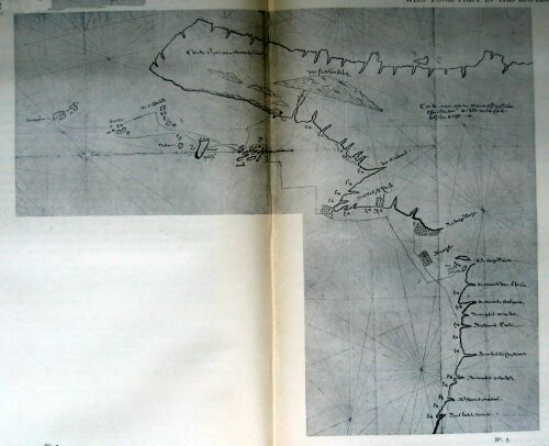
No. 7. Kaart van den opperstuurman AREND MARTENSZ. DE LEEUW, der Zuidwestkust van Nieuw Guinea en der Oostkust van de Golf van Carpentaria (Chart, made by the upper steersman Arend Martensz. De Leeuw, of the Southwest coast of New-Guinea and the East-coast of the Gulf of Carpentaria)
{Page 47}
2.
VOYAGE OF THE ARNHEM ALONE UNDER THE COMMAND OF VAN COOLSTEERDT, AFTER THE SHIP PERA AND HERSELF HAD PARTED COMPANY ON THE 27TH OF APRIL, 1623.
A.
Letter from the Governor of Banda to the Governor-General Pieter De Carpentier, May 16, 1623.
Noble, Worshipful, Wise, Valiant and very Discreet Sir,
The day before yesterday...we sighted...a ship. We forthwith presumed it to be Mr. Carstens, or perhaps one of the Yachts Pera or Arnehem...The ship turned out to be the Arnehem, which during the preceding night had lost her rudder...
(They) have not done much worth mentioning, for at the place where the chart [*] they had with them, led them to expect an open passage, they did not find any such, so that they could not get to the island they wished to reach...[**]
[* It is highly probable that this is another allusion to a chart of the voyage of Willem Janszoon with the Duifken in 1605-1606, because other documents concerning this expedition of the Arnhem and the Pera put it beyond a doubt that they had on board a chart of the voyage of the ship Duifken. In that case the passage in the text proves that Willem Janszoon already suspected the existence of Torres Strait, since the "open passage" can hardly refer to anything else.]
[** The remaining part of the letter refers to the time when the two ships were still together, and contains nothing new.]
Done in the Castle of Nassauw at Nera in the island of Banda, this 16th of May, A.D. 1623. (signed) ISACK De BRUNE.
B.
Letter from the Governor-General Antonio Van Diemen to "Commander" Gerrit Thomaszoon Pool, February 19, 1636.
Worshipful, Provident, very Discreet Sir,
With the present we also [*] send you a chart of the coasts made A.D. 1623 by the Yachts Pera and Arnhem, together with a small map of the South-land as surveyed by divers ships coming from the Netherlands, both of which may be of use to Your Worship [**]...
Done in the Castle of Batavia, February 19, A.D. 1636.
(signed) ANTONIO VAN DIEMEN
[* Vis. together with the Instructions of Febr. 19 for Pool's expedition to the Southland; see infra.]
[** To wit, with a view to the voyage just referred to.]
C.
Instructions for Pool, Febr. 19, 1636.
...Failing ulterior instructions, we desire you to sail as quickly as possible from Banda to Arnhems and Speultsland, situated between 9 and 13 degrees Southern Latitude, discovered A.D., 1623, as you may further see from the annexed chart [*]...
[* This, then, is the chart of the "coasts made A.D. 1623 by the yachts Pera and Arnhem"; for the "small map" handed to Pool, in the second place referred to in the above letter of Febr. 19, 1636, refers to surveyings of the west-coast of Australia by ships going from the Netherlands to India, and can therefore have nothing to do with the expedition of 1623. Arnhems- and Van Speults Land were accordingly discovered on the voyage of the Pera and the Arnhem. Now the journal of the Pera shows that she did not discover them, so that we are led to the conclusion that Arnhems- and Van Speults Land were discovered by the ship Arnhem.]
{Page 48}
D.
Letter from the Governor-General and Councillors to the Managers of the E.I.C., December 28, 1636.
...[The ships of Pool's expedition touched at] the native village of Taranga, situated at the south-western extremity of Arouw, and then sailed southward, hoping to be able to run on an easterly course in order to execute their orders; they, however, met with strong south-east winds and very high seas besides; in 11 degrees S.L. they discovered vast lands, to which they gave the names of Van Diemen's and Maria's Land, and which we suspect to be Arnhems or Speults's islands, though they extend in another direction than the latter [*].
[* Cf. as regards the situation of Arnhem's and Van Speult's Lands my Lite of Tasman, pp. 101 and 102, and the charts there referred to. Of the Nolpe-Dozy chart, of which there is question in note 4 on p. 102 of the book just mentioned, a reproduction will be found in Remarkable Maps, with a note by myself.]
The council of the said yachts, finding they could not run on an eastern course, after discovering and surveying Arnhem's Land twenty miles to westward, resolved to steer their course northward again past the islands of Timor and Tenember, and thus return to Banda, where they arrived on July 7...
E.
Instructions for Tasman, 1644.
...The third voyage was undertaken from Amboyna in the month of January 1623 with the Yachts Pera and Arnhem, commanded by Commander JAN CARSTENS, for the purpose of entering into friendly relations with the inhabitants of the islands of Key, Arou and Tenimber, and of exploring Nova Guinea and the South-lands, on which occasion alliances were made with the islands aforesaid and the south-coast of Nova Guinea was further discovered...but owing to untimely separation the Yacht Arnhem, after discovering the large islands of Arnhem and Speult, returned to Amboyna unsuccessfully enough, while the Yacht Pera, continuing her voyage, navigated along the south coast of Nova Guinea as far as a shallow bay in 10 degrees, and afterwards along the west coast of the same land as far as Cape Keer-Weer, whence she further explored the coast to southward as far as 17 degrees near the Staten river, where she saw the land stretching farther to westward, after which she returned again to Amboyna...
{Page 49}
XV. (1623) VOYAGE OF THE SHIP LEYDEN COMMANDED BY SKIPPER KLAAS HERMANSZ(OON) FROM THE NETHERLANDS TO JAVA.--FURTHER DISCOVERY OF THE WEST-COAST OF AUSTRALIA.
Journal kept on board the ship Leyden from the Texel to Batavia, 1623.
Laus Deo. This 9th day of July, A.D. 1623 in the ship Leyden...
On the 15th do. Latitude 27° 15'; during the last twenty-four hours we sailed 16 miles East by North and East-north-east...At noon we saw a large dead fish floating near our ship, with a great many birds perched on its carcase.
On the 16th do. Latitude 26° 27'; sailed 16 miles in 24 hours North by east...
On the 17th do. Latitude 27° 23'; from last night sailed 16 miles East-south-east...
On the 18th do. Latitude 27° 25'; sailed 24 miles East-south-east, East by South and East-north-east, on the whole keeping an eastward course...
On the 19th do. Latitude 27' 20'. sailed due east 20 Miles in 24 hours...
On the 20th do. Latitude 27° 20' sailed 20 miles these 24 hours North-east, East-north-east and East, with a light breeze, fair weather, and a West-south-west wind; course held east.
On the 21st do. in the morning we sighted Eendrachtsland in Latitude 27° at about 6 miles' distance South-west by west; we sounded off it in 61 fathom fine gravel bottom, the land showing outwardly like Robben Island in the Taffel Bay; at noon in Latitude 26° 43' we shaped our course to northward, and afterwards drifted in a calm.
On the 22nd do. Latitude 26` 36, sailed and drifted about 4 miles, at about 8 miles' distance North~north-west from the land. We sighted everywhere a hilly coast with large bays, with low-lying land in between, the whole covered with dunes; we drifted in a calm, our course being North-west by West.
On the 23rd do. Latitude 26° 3'; during the last twenty-four hours we mostly drifted in a calm at about 3 or 4 miles' distance from the coast; here we sighted a large inlet, looking like a river or bay. We sounded in 80 fathom, good sandy bottom; in the afternoon there was a light breeze from the South-south-west, our course being North-west by West. In the evening we saw the farthest extremity of the land north by east at six miles' distance from us.
On the 26th do. Latitude 25° 48', we did our best to keep off the land, which extended North-north-west and East-south-east. The land looked like the west-coast of England with many reddish rocks; out at sea there were plenty of cliffs and sunken rocks; at noon the wind went round to South-west afterwards to the south; we held our course North-west by North. In the evening the endmost land lay North by east of us at about 7 miles' distance.
On the 27th do. WILLEMTGEN JANSZ., wedded wife Of WILLEM JANSZ. of Amsterdam, midshipman, was delivered of a son, who got the name of SEEBAER VAN NIEMELANT. At noon Latitude 24° 15', sailed northward both in a calm and with variable winds, generally on a North-by-west course...[*] miles, our course being north, and the wind south with a fine breeze.
[* Left blank.]
On the 29th do. Latitude 20° 56'.
On the 30th do. Latitude 18° 56'; the wind being east, we could not get higher than north. We saw a good deal of rock-weed floating about, and plenty of fish near the ship...
{Page 50}
XVI. (1624) DISCOVERY OF THE TORTELDUIF ISLAND (ROCK).
A.
Daily Register [*] of what has happened here at Batavia from the first of January, A.D. 1627.
[* This Daily Register has been edited by me ('s Gravenhage, Nijhoff, 1896).]
...On the 21st [of June] there arrived here from the Netherlands the advice-yacht Tortelduiff...which had left the Texel...on the 16th of November, 1623...
B.
Hessel Gerritsz Charts, 1627 [*] (Nos. 4 and 5.--VII, C, D).
[* The situation of Tortelduif island was accordingly known as early as 1677. The voyage Of 1623-1624 is the only one made to India by the ship of that name (see LEUPE, Zuidland, p. 48). If we take for granted that this ship gave its name to the island (rock), which is highly probable, then the name must have been conferred in 1624. The note of interrogation in the text is only meant to ward off the charge of over-hasty inference on my part.]
XVII. (1626) VOYAGE OF THE SHIP LEIJDEN, COMMANDED BY SKIPPER DANIEL JANSSEN COCK, FROM THE NETHERLANDS TO JAVA.--FURTHER DISCOVERY OF THE WEST-COAST OF AUSTRALIA.
Copy of the Journal kept by me DANIEL JANSSEN COCK, Captain and Skipper of the ship LEIJDEN, which set sail on the 17th of May 1625, of all that has occurred during the voyage.
Praise God. April 1626.
26 do. Latitude 29½ degrees, sailed 36 miles...
27 do. Latitude 27 2/3 degrees, sailed 28 miles; course held north-east; the wind being south and south-west, I had the top-gallants set. God grant what is best for us. Amen. Course kept North-north-east.
28 do. In the morning we took the sun's azimuth: between 7 and 8 degrees to northward, the rise being 16 degrees. We sighted land, being the Southland, at 10 miles' distance. We found a strong current here, with a depth Of 40 fathom. The current set to eastward or straight against the land. In the evening we shaped our course to North-west.
29 do. Latitude slightly under 26°. the weather was calm, so that we ran along the coast, North and at times North-north-west. In the evening I saw the endmost (?) land north-east of me; the wind blowing from the south.
30 do. In the morning I took the sun's azimuth: between 9 and 10 degrees to northward, the rise being 16½ degrees, remains 7½ degrees. At noon Latitude 24° 47'. Course held North by west, with a southerly wind; sailed 18 miles; in the evening it fell calm...
{Page 51}
XVIII. (1627) DISCOVERY OF THE SOUTH-WEST COAST OF AUSTRALIA BY THE SHIP HET GULDEN ZEEPAARD, COMMANDED BY PIETER NUIJTS, MEMBER OF THE COUNCIL OF INDIA, AND BY SKIPPER FRANÇOIS THIJSSEN OR THIJSZOON.
A.
Dail Register of what has happened here at Batavia from the first of January, 1627 [*].
[* On p. 307 of my edition of the Daily Register of 1624-1629.]
...On the 10th [of April] there arrived here from the Netherlands the ship t' Gulden Seepaart fitted out by the Zealand Chamber [*], having on board the Hon. Pieter Nuyts, extraordinary Councillor of India, having sailed from there on the 22nd of May, 1626...
[* The Register of outgoing vessels of the E.I.C. shows that the skipper's name was François Thijssen or Thijszoon.]
B.
Hessel Gerritsz-Huydecoper Chart (No. 5.--VII D).
This chart has 't land van Pieter Nuijts (discovered January 26 [*], 1627) and the islands of Sint François and Sint Pieter.
[* Some of the charts have February, but most of them January. This month is also mentioned as the time of the discovery in the instructions for Pool (1636, see infra) and for Tasman (1644). Cf. my Life of Tasman, pp. 97f.]
XIX. (1627) VOYAGE OF THE SHIPS GALIAS, UTRECHT AND TEXEL, COMMANDED BY GOVERNOR-GENERAL JAN PIETERSZOON COEN. FURTHER DISCOVERY OF THE WEST-COAST OF AUSTRALIA.
A.
Letter of Jan Pieterszoon Coen to the Directors of the E.I.C.
Most Noble Wise Provident Very Discreet Gentlemen,
The present is a copy of our letter written from Illa de Mayo on the 15th of April last...On July the 22nd we sailed from the Tafelbay with the ships Galias, Utrecht and Texel. When coming out to sea we got the wind from the south, so that we could not sail higher than the Cape, and lost eight days during which we made no progress. Then getting a favourable wind we remained together in 37½ degrees Southern Latitude up to the 10th of August; the following night, however, the rudder of the Galias broke in a strong wind, so that the ship became ungovernable, and the sails were dashed to pieces, in consequence of which she got separated from the other two ships, who had failed to observe the accident of the Galias owing to the darkness; {Page 52} the next day, the rudder having been repaired, we continued our voyage with the Galias, and in the afternoon of the 5th of September in 28½ degrees S. Lat. came upon the land of d'Eendracht. We were at less than half a mile's distance from the breakers before perceiving the same, without being able to see land. If we had come upon this place in the night-time, we should have been in a thousand perils with our ship and crew. In the plane charts the reckonings of our steersmen were still between 300 and 350 miles from any land, so that there was not the slightest suspicion of our being near any, although the reckoning of the chart with increasing degrees showed only 120 miles, and the reckoning by the terrestrial globe only 50 miles distance from the land. But to this little attention had been paid. It seems certain now that the miscalculation involved in the plane chart from Cabo de bon' Esperança to the Southland in 35 degrees latitude gives an overplus of more than 270 miles of sea, a matter to which most steersmen pay little attention, and which has brought, and is still daily bringing, many vessels into great perils. It would be highly expedient if in the plane charts most in use, between Cabo de bon' Esperança and the South-land south of Java, so much space were added and passed over in drawing up the reckonings, as is deducible from the correct longitude according to the globosity of earth and sea. We would request Your Worships to direct attention to this point, and have such indications made in the plane chart as experts shall find to be advisable; a matter of the highest importance, which if not properly attended to involves grievous peril to ships and crews (which God in his mercy avert).
In this plane chart the South-land also lies fully 40 miles more to eastward than it should be, which should also be rectified.
On the 20th of September we struck the South-coast of Java about 50 or 60 miles eastward of its western extremity...
Your Worships' obedt. servant J.P. COEN.
At Batavia, October 30, 1627.
XX. (1627) VOYAGE OF THE SHIP HET WAPEN VAN HOORN, COMMANDED BY SUPER CARGO J. VAN ROOSENBERGH. FURTHER DISCOVERY OF THE WEST-COAST OF AUSTRALIA.
Letter Of Supercargo J. Van Roosenbergh to the Directors of the E.I.C., November 8, 1627.
Worshipful Wise Provident Very Discreet Gentlemen,
You have no doubt received my letter from Illa de Mayo...
On the 7th of September we resolved to run for the South-land, that we might be near Java before the middle of October. On the 17th do. we sighted the land of d'Eendracht near Dirck Hartochs reede [road-stead], at about 7 miles' distance from us; the land was of middle height, something like D'overen [Dover] in England; it is less low than has been asserted by some, and of a whitish hue, so that at night it cannot be seen before one is quite close to it. When by estimation we were at two miles' distance from the land, the coast seemed to have a foreshore consisting of small hills here and there. According to our observations the land lay quite differently from what the chart would have us believe, to wit, North by West and North-north-west, from a point three miles south of the aforesaid height to a point 8 or 9 miles north of it; which were the farthest points seen by us; this constituting a difference Of 3½ {Page 53} points with the chart, which makes it North-north-east and South-south-west. We cast the lead five miles off the shore in 75 fathom, muddy bottom mixed with small red pebbles, and five glasses afterwards, two miles off shore, in 55 fathom sandy bottom, for hardly anything was found sticking to the lead when heaved. We had seen no other signs of land beyond gulf-weed floating about in small quantities just as in the Sargasso Sea, and some land-birds flying high overhead. The many-coloured birds which we met near the islands of Tristan de Aconcha, left us two days before, just as they did when we got near Cabo de bone Esperança, so that they would seem to dislike the land. Instead of them, we saw a black bird with a white tail, having white streaks here and there under its wings; a bird, it seems, of rare occurrence. Three or four days before we also saw a number of sanderlings. Close inshore we also saw a quantity of cuttlebone, but the pieces were very small and scattered, so that they could hardly be seen in hollow water, except by paying very close attention to them and only 6 or 8 miles off shore, seeing that the steady west-wind prevents their getting out to sea, which they would certainly do, if now and then the wind blew from the east for a few days in succession. Careful estimations based on the globosity of the earth will give the best signs after all. By estimation we have got into...[*] Longitude, some of our steersmen having got one or two degrees more, some less, which in the plane charts makes a considerable difference, about 217 miles by calculation. I repeat that since I have seen the land a good deal earlier, it will be expedient in the plane chart to mark out a distance of about 200 miles, to westward of St. Paulo island and to eastward of Madagascar, the said distance to be passed over in drawing up reckonings, seeing that the plane chart involves serious drawbacks; the same might well be done to eastward of the Cape, in such fashion as Your Worships' cartographers and other experts, such as Master C. J. Lastman, shall find to be most expedient for the Company's service. Seeing that we had nothing to do near the coast, and there was a fair wind blowing for us to make use of, we deemed it advisable that night to run north-west, and the next morning, having got north into 20 degrees S. Lat., from there to hold a north by-west course for Java, whither God Almighty may in safety conduct ourselves and those who shall come after us.
[* Left blank.]
On the 27th do. in the evening, when it had got dark, the water suddenly turned as white as butter-milk, a thing that none of those on board of us had ever seen in their lives, and which greatly surprised us all, so that, concluding it to be caused by a shallow of the sea, we set the foresail and cast the lead, but since we got no bottom, and with the rising moon the water again resumed its usual colour, we made all sail and ran on full speed, satisfied that the strange colour had been caused by the sky, which was very pale at the time. On the 28th in the morning very early, the water became thick, and shortly after we sighted land, being two islands, each of them about 2 miles in length; at 4 miles' distance from the land we cast the lead in 65 fathom sandy bottom. At noon in Latitude 8°, three miles off shore, we found ourselves to have run too far to eastward, wherefore we held our course to westward up to the 2nd of October, when by God's grace we passed the Princen islands, and arrived off Bantham on the 9th do. By estimation the land of d'Eendracht is marked in the chart fifty miles too far to eastward, which should also be rectified...
Done in the ship 't Wapen van Hoorn, November 8, A.D. 1627, lying at anchor before Batavia.
Your Worships' obedt. Servant
J. V. ROOSENBERGH.
{Page 54}
XXI. (1628) DISCOVERY OF THE NORTH-WEST COAST OF AUSTRALIA BY THE SHIP VIANEN (VIANE, VIANA), COMMANDED BY GERRIT FREDERIKSZOON DE WITT.--DE WITT'S LAND.
A.
Letter of the Governor-General and Councillors to the Managers of the E.I.C. November 3, 1628.
...[We] thought fit to give orders for the ship Vyanen [*] to sail to the strait of Balamboan. [She] sailed [from Batavia] thither on the 14th of January, and from there stood out to sea on the 25th do. She was by head-winds driven so far to south-ward that she came upon the South-land beyond Java where she ran aground, so that she was forced to throw overboard 8 or 10 lasts of pepper and a quantity of copper, upon which through God's mercy she got off again without further damage...
[* That commander Gerrit Frederikszoon De Witt, was on board this ship, is proved by an original letter of his, dated August 6, 1628 (Hague State Archives).]
B.
See the Hessel Gerritsz--Huydecoper Chart (No 5.--VII D), which has G. F. De Witts-land.
C.
Instructions for Tasman, 1644 [*].
[* The well-known chart of TASMAN, 1644 (see my Life of, Tasman, PP. 71-73) also has the name G. F. De Witt's Land.]
...Meanwhile in the year 1627 the ship t' Gulde Zeepaert,...discovered...the south coast of the great Southland, and in the following year 1628 the ship Viana, homeward bound from Batavia, equally unexpectedly discovered the coast of the same land on the north side in the Southern Latitude of 21 degrees, and sailed along it a distance of about 50 miles; none of these discoveries, however, resulting in the obtaining of any considerable information respecting the situation and condition of this vast land, it only having been found that it has barren and dangerous coasts, green, fertile fields and exceedingly savage, black, barbarian inhabitants...
XXII. (before 1629) DISCOVERY OF JACOB REMESSENS-, REMENS-, OR ROMMER-RIVER, SOUTH OF WILLEMS RIVER [*].
[* I do not know the date of this discovery. Since Pelsaert was acquainted with it, it must have taken place before 1629 or 1628. It cannot have been much earlier, as the name is not found in Hessel Gerritsz's charts. I must mention, however, that Leupe has found a steersman of the name of Jacob Remmetsz referred to in the archives of the E.I.C. about the year 1619.]
A.
Daily annotations of Pelsaert, 1629 (See infra).
...This 16th [of June]...we were in Latitude 22 degrees 17 minutes. I intended to sail to Jacop Remmessens river.
{Page 55}
B.
Keppler Map (No. 6.--VII E).
XXIII. (1629) [*]. SHIPWRECK OF THE SHIP BATAVIA UNDER COMMANDER FRANÇOIS PELSAERT ON HOUTMANS ABROLHOS [**].--FURTHER DISCOVERY OF THE WEST-COAST OF AUSTRALIA.
[* In the year 1628 certain other Dutch vessels sighted or touched at the west-coast of Australia on their outward voyage to India (see LEUPE, Zuidland, p. 58; my edition of the Daily Register of Batavia, p. 341). What we know on this point is without interest. I merely mention the fact here, without entering into particulars.]
[** The fact and the particulars of this shipwreck have become sufficiently known, the narrative of it having been published repeatedly and in different languages (see TIELE, Mémoires bibliographiques, pp. 262-268; Id. Bibliographie Land- en Volkenkunde, pp. 172, 190-191, 258f.--Cf. e.g. also MAJOR, Early Voyages, pp. LXXXIX--XCII; 59-74). I accordingly print in the text only what is strictly necessary; but I give almost in extenso Pelsaert's journal of his exploratory voyage along the west-coast of Australia.]
A.
Woeful diurnal annotations [of Commander PELSAERT] touching the loss of our ship Batavia, run aground on the Abrolhos, or rocks of Fredrick Houtman, situated in 28½ degrees S. Lat., at 9 miles' distance from the Southland.
On the fourth of June [1619], it being Whitmonday, with a light, clear full moon, about two hours before daybreak...I felt the ship's rudder strike the rocks with a violent horrible shock. Upon which the ship's course was forthwith checked by the rocks...I rushed on deck, and found all the sails atop; the wind south-west; our course during the night had been north-east by north, and we were now lying amidst thick foam. Still, at the moment, the breakers round the ship were not violent, but shortly after the sea was heard to run upon us with great vehemence on all sides...
[When] day broke, we found ourselves surrounded by cliffs and shoals...
I saw no land that I thought would remain above water at high tide, except an island, which by estimation was fully three miles from the ship. I therefore sent the skipper to two small islets or cliffs, in order to ascertain whether our men and part of our cargo could be landed there. About 9 o'clock the skipper returned, informing me that it was well-nigh impossible to get through the rocks and cliffs, the pinnace running aground in one place, and the water being several fathom deep in another. As far as he could judge, the islands would remain above water at high tide. Therefore, moved by the loud lamentations raised on board by women, children, sick people, and faint-hearted men, we thought it best first to land the greater part of our people...
[On June 5] at their earnest instances to move me, it was determined, as shown by the resolution, that we should try to find fresh water in the neighbouring islands, or on the mainland coast in order to save their lives and our own; and that, if no water should be found, we should in that case at the mercy of God with the pinnace continue our voyage to Batavia, there to make known our calamitous and unheard-of disasters...
{Page 56}
This day the 6th do...[we] set sail in the pinnace, and on this day touched at two separate islands, where we found at best some brackish water, which had collected in the cavities of the rocks on the beach after the rain, but it was largely mixed with seawater. On the 7th do. we remained here, in order to repair our pinnace with a plank, for we found that without this it would have been impossible to reach the mainland...
On the 8th do. in the morning we set sail from this island for the mainland...
At noon we were in 28° 13' Lat., and shortly after sighted the mainland, which we estimated to lie 6 miles north by west of our ship. The wind blew from the west, and we sounded 25 and 30 fathom about 3 o'clock in the afternoon. During the night we kept off the land, and after midnight shaped our course for it again.
In the morning of the 9th we were still about 3 miles from the land, the wind being mainly north-west with some rain; in the last 24 hours we covered 4 or 5 miles by estimation, course held north by west. The land here extends chiefly north by west and south by east. It is a barren, rocky coast without trees, about the height of Dover in England.
We here saw a small inlet, and some low land with dunes, which we meant to touch at, but on nearer approach we found a heavy sea and violent breakers on the shore, while at the same time the swell from the west suddenly began to run towards the land so strongly and so high, that we could hardly keep off it, the less so as the storm always rose in violence.
On the 10th do. we kept holding off and on for twenty-four hours owing to the strong wind, while the storm from the north-west, which stood on the boat we had taken with us, forced us to cut the same adrift and to throw overboard a part of the bread we had with us, together with other things that were in the way, since we could not keep the water out of our pinnace.
During the night we were in great peril of foundering owing to the violent gale and the hollow seas. We could not keep off the land, because we did not venture to carry sail, and so were wholly at the mercy of wind and waves, while it kept raining the whole night.
On the 1lth do. in the morning the weather began somewhat to abate, the wind turning to west-south-west, upon which we held our course to northward, but the sea was still very rough.
On the 12th do. at noon we were in Lat. 27°; we ran close along the land with a south-east wind, but could find no means to get near the land with the pinnace, owing to the violent surf; we found the coast falling off very steeply, without any foreland or inlets, such as other lands are found to have: in short it seemed to us a barren, accursed earth without leafage or grass.
On the 13th do. at noon we were in Lat. 25° 40'; we found ourselves drifting very rapidly northward, having rounded the point where the land extends mainly N.N.E. and S.S.W. During the last 24 hours our course was chiefly north. The coast was steep, consisting of red rock, without foreland, of the same height almost everywhere, and impossible to touch at owing to the breakers.
On the 14th do. in the morning there was a faint breeze, but during the day it fell a dead calm. At noon we were in Lat. 24°; course held N., with a S.E. wind; during the whole of the day the current carried us northward against our will, for we {Page 57} were running along the land with small sail. In the afternoon we saw smoke rising up from the land; we accordingly rowed to shore in order to land if possible, with our spirits somewhat raised, for I concluded that if there were men, there must be water too. Coming near the shore, I found it to be a steeply rising coast, full of rocks and stones, with the surf running violently; nevertheless 6 of our men swam ashore, and we remained at anchor with the pinnace in 25 fathom outside the surf. The men now searched for water everywhere until nightfall, without, however, finding any; they also saw four men coming up to them, creeping on all fours, but when our men all of a sudden emerged from a depression of the ground, and approached them, they sprang to their feet, and ran off in full career, all which we could distinctly see from the pinnace. They were black men, stark naked, without the least covering. In the evening our men swam on board again, all of them grievously wounded by the rocks on which they been dashed by the breakers. We therefore weighed anchor again to seek a better place for landing, and ran on during the night with small sail close along the shore, but out of the reach of the surf.
On the 15th do. in the morning we were near a point of the coast off which a large reef extended about a mile in length, we ran in between the land and this reef, which we estimated to be in 23° Lat., and thus sailed along the coast, along which there was another reef, inside which the water seemed to be very smooth and still; we did our best to get inside this second reef, but did not find an opening before noon, when we saw a passage where there was no surf, we ran into it, but found it to be full of stones, and sometimes no more than one or two feet deep.
This coast had a foreshore covered with dunes about a mile in width, before you come to the higher part. We therefore began to dig in divers places, but the water proved to be salt; some of us went to the higher land, where by good luck we found in a rock a number of cavities, in which a quantity of rain-water had collected. It also seemed that a short time before there had been natives there, for we found some crab-shells lying about and here and there fire-ashes. Here we somewhat quenched our cruel thirst, which almost prevented us from dragging ourselves along, for since the loss of our ship we had had no more than one or two mutchkins daily, without any wine or other drink. Besides quenching our own thirst, we here gathered about 80 cans of water, and remained there for the night.
On the 16th do. in the morning we continued our exploration in order to find out whether there were more water-pits in the mountains, but our search was fruitless, for it seemed not to have rained there for a long time past, and we found no traces of running water, the higher ground being again very barren and unpromising, without any trees, shrubs or grass, but with plenty of high ant-hills in all directions. These ant~hills consisted of earth thrown up, and from afar somewhat resembled huts for the abode of men.
We also found such multitudes of flies here, which perched on our mouths and crept into our eyes, that we could not keep them off our persons. We likewise saw 8 blacks here, each of them carrying a stick in his hand; they came within a musketshot's distance of us, but when we went up to them, they ran off, and we could not get them to stop, that we might come near them. Towards noon, when we found there was no more water to be had, we set sail again, and passed through another opening of the reef a little more to northward. We were here in 22° 17' Lat. I intended to run on to Jacop Remessens river, but the wind went round to North-east, so that we could not keep near the land, and seeing that we were now more than {Page 58} 100 miles from those we had left behind on the island-rocks, and that up to now we had not found water enough to assist them all, but only so much as would afford two mutchkins daily to ourselves, we were compelled to resolve to do our best in order with God's help to continue our voyage to Batavia as expeditiously as possible, that the Hon. Lord Governor-general might order measures to be taken for the succour of those we had left behind...
On the 7 th do. [of July] we arrived in the road-stead of Batavia at nightfall.
God be thanked and praised.
B.
Diurnal anotations on my [PELSAERT'S] second voyage to the South-land, by order of the Hon. Lord Governor-general Jan Pietersen Coen, with the Yacht Sardam, for the purpose of rescuing and bringing hither the men belonging to our lost ship Batavia, together with the ready money and the goods that it shall be found possible to salve.
This day the 15th Of July We set sail in the morning with the land-wind...
This day the 1st of September at noon we were in 29° 16' Southern Latitude [*], with a variable wind, so that we found it impossible to get to eastward.
[* The ship had already sailed farther south than Houtman's Abrolhos.]
On the 2nd do. the wind went round to the north with a top-gallant gale; at noon we were in 30° 16' S.L. and found we had drifted a long way to southward; in the evening the wind turned to the north-west; course held N.E. by north.
On the 3rd do. in the morning the wind was blowing from the west; we saw a good deal of rock-weed floating about and also a number of cuttle-bones. We therefore turned our course to eastward, and at noon we saw the mainland of the South-land, extending N.N.W. and S.S.E.; we were at about 3 miles' distance from it and saw the land extending southward for 4 miles by estimation, where it was bounded by the horizon. We sounded here in 25 fathom, fine sandy bottom. It is a treeless, barren coast with a few sandy dunes, the same as to northward; we were in 29° 16' Southern Latitude, turned our course to north-west, the wind being W.S.W., but the hollow seas threw us close to the land, so that in the evening we had to drop anchor at one mile's distance from it; at two glasses in the first watch our anchor was broken in two, so that we had to bring out another in great haste.
On the 4th do. in the morning the wind was S.W. by S., still with a very hollow swell. During the day the wind went round to S.S.W., upon which we weighed anchor and got under sail before noon. We stood out to sea on a W.N.W. course in order to get off the lee-shore. At noon we were in 28° 50' S.L., where the land began to fall off one point, to wit North by west and South by east. In the afternoon the wind went round to the south, and we shaped our course westward. Towards evening we became aware of a shoal straight ahead or west of us, at only a musket-shot's distance, we being in 25 fathom fine sandy bottom. We turned the rudder and ran off it half a mile to E.S.E., where we came to anchor in 27 fathom fine bottom; from noon till the evening we had been sailing on a W.N.W. course, and we were now at 5 miles' distance from the mainland. In the night it fell a dead calm with fine weather and a south-by-east wind.
{Page 59}
On the 5th do. in the morning the wind being S.S.E. with lovely weather, we weighed anchor and sailed S.S.W. for an hour, at the end of which we observed more breakers, shallows and islets ahead of us and alongside our course; the wind then turned more to eastward, so that we could run to the south and S.S.E. This reef or shoal extended S.S.W. and N.N.E.; along it we sounded in 27, 28 and 29 fathom sandy bottom; at 11 o'clock in the forenoon we had lost sight of the mainland; at noon we were in 28° 59' S. Lat., the extremity of the reef lying W.S.W. of us, and we being in 50 or 60 fathom, foul steep bottom. In the afternoon the wind began to abate, but the current carried us to the west, while the rocks here fell off far to westward, we being at about 87 miles' distance from the mainland by estimation. We had a dead calm the whole night and drifted along the rock, on which we heard the waves break the whole time.
On the 6th do. in the morning we had lost sight of the rocks; about 10 o'clock the wind began to blow from the W.N.W., so that we ran nearly in the direction of the rocks. At noon we were in 28° 44' S. Lat.; it began to blow hard from the N.W., so that in the afternoon we kept tacking off and on, and found ourselves carried northward by the current. In the evening we stood out to sea away from the rocks again, and sounded in 40 fathom foul rocky bottom; this shallow here extends seaward S.E. and N.W. In the evening it began to blow very hard, so that we had to run on with shortened mainsails, the wind being variable.
On the 7th do. in the morning the wind abated, so that we made sail again; at noon we found our latitude to be 29° 30'; we went over to northward to get sight of the mainland again, but the wind suddenly turned sharply to W.N.W., so that we had to stand out to sea again.
On the 8th do. at noon we were in 29° 7' S. Lat., course held N.E. In the evening we saw the breakers again. We therefore stood out to sea on a west-south-west course the whole night with a north-west-wind; and it began to blow so hard that we had again to take in the topsails.
On the 9th do. in the morning we shaped our course to the land again; at noon we were in Lat. 29° and for the rest of the day we kept tacking off and on; towards the evening there blew a storm from the N.W., so that we could hardly keep our main-sails set.
On the 10th do. we made sail again in the morning; at noon we were in 29° 30' S. Lat., with a westerly wind and a top-gallant gale.
On the 11th do. it was calm in the morning, but with a very hollow sea, while the wind blew from the W.N.W., so that we could not get to the north, if we did not wish to come upon or near the rocks. At noon we were in 28° 48' S. Lat. The wind continued variable, so that in the night we had to drift with our foresail set until daybreak.
On the 12th do. we made sail again at daybreak, shaping our course to the east. We ran on till noon, when we found ourselves to be in in 28° 13' S. Lat. We therefore ran somewhat more to the south again, in order to reach the latitude Of 28° 20' exactly; the wind was south-west with a heavy swell of the sea. In the afternoon, two hours before sunset we again sighted the rocks, which we estimated to be still two miles from us. We cast the lead in 100 fathom fine sandy bottom, but when we had come to half a mile's distance, we sounded 30 fathom foul rocky bottom. In the night we shaped our course two points more to seaward, and in the daywatch made for the land again.
{Page 60}
On the 13th do., three hours after sunrise we again sighted breakers ahead, and having made up our reckoning, we found we had lost a mile north, since the wind had been S.S.E. This proved to be the northernmost extremity of the Abrolhos. Therefore, since I found we always came too high or too low, and it was very dangerous to touch at them from the outside owing to the high swells and foul bottom, I resolved to keep tacking off the outermost shoal. After this we went over again nearly to weatherward with a S.S.E. wind, keeping an eastern course. When we had got inside a small distance, we directly had a fine sandy bottom in from 30 to 35 fathom; at noon we were in 28° S. Lat., shortly after we again saw the mainland of the Southland. In the evening, as it began to blow hard, we came to anchor at about 2 miles' distance from the land in 30 fathom, fine bottom.
On the 14th do. there was a stiff gale from the S.S.E., so that we could not get in our anchor, and remained here all day.
On the 15th do. the wind was still equally strong, but towards noon it got somewhat calmer, so that we could get in our anchor. At noon we were in 27° 54' S. Lat. We kept tacking the whole day with a S.S.E. wind, in order to gain the south, and at night found we had gained two miles. When it got dark, we again came to anchor in 30 fathom fine bottom.