Chapter XXX
Reading edition
OTHER PLACES OF NOTE
I. PANJÁB.
(a) Ambála Division.
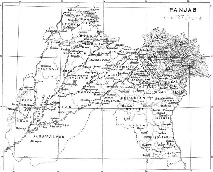
Ambála, 30·2 N.—76·4 E. Population 80,131, of which 54,223 in Cantonments. A creation of British rule. It became the headquarters of the Political Agent for the Cis-Sutlej States in 1823, and the Cantonment was established in 1843. The Native City and the Civil Lines lie some miles to the N.W. of the Cantonment. Headquarters of district and division.
Bhiwání (Hissár), 28·5 N.—76·8 E. Headquarters of tahsíl in Hissár. Population 31,100. On Rewárí—Ferozepore branch of Rájputána—Málwa Railway. Has a brisk trade with Rájputána.
Hánsí (Hissár), 29·7 N.—75·6 E. Headquarters of tahsil. Population 14,576. A very ancient town. In centre of canal tract of Hissár, and a local centre of the cotton trade.
Hissár, 29·1 N.—75·4 E. Headquarters of district. Population 17,162. Founded by the Emperor Firoz Sháh Tughlak, who supplied it with water by a canal taken from the Jamna. This was the origin of the present Western Jamna Canal. Is now a place of small importance.
Jagádhrí (Ambála), 30·1 N.—77·2 E. Headquarters of tahsil. Population 12,045. Connected with the N.W. Railway by a light railway. The iron and brass ware of Jagádhrí are well known.
Kaithal (Karnál), 29·5 N.—76·2 E. Headquarters of subdivision and tahsil. Population 12,912. A town of great antiquity. Kaithal is a corruption of Kapisthala—the monkey town, a name still appropriate. Timúr halted here on his march to Delhi. Was the headquarters of the Bhais of Kaithal, who held high rank among the Cis-Sutlej Sikh chiefs. Kaithal lapsed in 1843.
Karnál, 29·4 N.—76·6 E. Headquarters of district. Population 21,961. On Delhi—Kálka Railway. Till the Western Jamna Canal was realigned it was most unhealthy, and the Cantonment was given up in 1841 on this account. The health of the town is still unsatisfactory. Trade unimportant.
Kasauli (Ambála), 30·5 N.—76·6 E. Small hill station overlooking Kálka. Height 6000 feet. The Pasteur Institute for the treatment of rabies is at Kasauli, and the Lawrence Military School at Sanáwar, three miles off.
Pánipat (Karnál), 29·2 N.—76·6 E. Headquarters of tahsíl. Population 26,342. On Delhi—Kálka Railway. An important place in Hindu and Muhammadan times (pages 172 and 179). Local manufactures, brass vessels, cutlery, and glass.
Pihowa (Karnál), 29·6 N.—76·3 E. A very sacred place on the holy stream Sarusti.
Rewárí (Gurgáon), 28·1 N.—76·4 E. Headquarters of tahsil. Population 24,780. Junction of main line and Rewárí—Bhatinda branch of Rájputána—Málwa Railway. Trade in grain and sugar with Rájputána.
Rúpar (Ambála), 30·6 N.—76·3 E. Headquarters of subdivision and tahsíl. Population 6935. Exchange market for products of Hills and Plains. Headworks of Sirhind Canal are at Rúpar.
Sirsa (Hissár), 29·3 N.—75·2 E. Headquarters of subdivision and tahsil. Population 14,629. Sirsa or Sarsútí was an important place in Muhammadan times. Deserted in the great famine of 1783 it was refounded in 1838. On the Rewárí—Bhatinda Branch of the Rájputána—Málwa Railway. Has a brisk trade with Rájputána.
Thanesar (Karnál), 29·6 N.—76·5 E. See pages 165 and 168. Noted place of pilgrimage. Headquarters of a tahsíl. Population 4719. The old Hindu temples were utterly destroyed apparently when Thanesar was sacked by Mahmúd in 1014. There is a fine tomb of a Muhammadan Saint, Shekh Chillí.
(b) Jalandhar Division.
Aliwál, 30·6 N.—75·4 E. Scene of Sir Harry Smith's victory over the Sikhs on 28th January, 1846.
Dharmsála (Kángra), 32·1 N.—76·1 E. Headquarters of district. On a spur of the Dhauladhár Range. A Gurkha regiment is stationed here. The highest part of Dharmsála is over 7000 feet, and the scenery is very fine, but the place is spoiled as a hill station by the excessive rainfall, which averages over 120 inches. In the earthquake of 1905, 1625 persons, including 25 Europeans, perished.
Fázilka (Ferozepore), 30·3 N.—74·3 E. Headquarters of sub-division and tahsíl. Population 10,985. Terminus of Fázilka extension of Rájputána—Málwa Railway, and connected with Ludhiána by a line which joins the Southern Panjáb Railway at Macleodganj. A grain mart.
Ferozepore, 30·6 N.—74·4 E. Headquarters of district. Population 50,836 including 26,158 in Cantonment. (See page 245.)
Ferozesháh (Ferozepore), 30·5 N.—74·5 E. The real name is Pherushahr. Sir Hugh Gough defeated the Sikhs here after two days' hard fighting on Dec. 21-22, 1845.
Jalandhar, 31·2 N.—75·3 E. Headquarters of district. Population 69,318, including 13,964 in Cantonment. The Cantonment lies four miles to the S.E. of the native town and three miles from the Civil Lines. (See page 241.)
Jawála Mukhí (Kángra), 31·5 N.—76·2 E. Celebrated place of Hindu pilgrimage with a famous temple of the goddess Jawálamukhí, built over some jets of combustible gas.
Kángra, 30·5 N.—76·2 E. Headquarters of tahsíl. Ancient name Nagarkot. The celebrated temple and the fort of the Katoch kings of Kángra were destroyed in the earthquake of 1905. (See pages 168, 171, 183.)
Ludhiána, 30·6 N.—75·5 E. Headquarters of district. Population 44,170. The manufacture of pashmína shawls was introduced in 1833 by Kashmírís. Ludhiána is well known for its cotton fabrics and turbans (p. 152).
Mudkí (Ferozepore), 30·5 N.—74·5 E. The opening battle of the 1st Sikh War was fought here on 18th December, 1845.
(c) Lahore Division.
Batála (Gurdáspur), 30·5 N.—75·1 E. Headquarters of tahsíl. Population 26,430. Chief town in Gurdáspur district on the Amritsar—Pathánkot Railway. Cotton, silk, leathern goods, and soap are manufactured, and there is a large trade in grain and sugar. The Baring Anglo-Vernacular High School for Christian boys is a well-known institution.
Dalhousie (Gurdáspur), 33·3 N.—75·6 E. A well-known hill station at height of 7687 feet, 51 miles N.W. of Pathánkot, from which it is reached by tonga. The Commissioner of Lahore and the Deputy Commissioner of Gurdáspur spend part of the hot weather at Dalhousie. It is a very pretty and healthy place, with the fine Kálatop Forest in Chamba close by, and is deservedly popular as a summer resort.
Gujránwála, 32·9 N.—74·1 E. Headquarters of district. Population 29,472. An active trade centre. Ranjít Singh was born, and the tomb of his father, Mahán Singh is, at Gujránwála.
Kasúr (Lahore), 31·8 N—74·3 E. Headquarters of tahsíl in Lahore. Population 24,783. Between Raiwind and Ferozepore on N.W. Railway, and has direct railway communication with Amritsar. A very ancient place and now an active local trade centre.
Nankána-Sáhib (Gujránwala), 31·6 N.—73·8 E. In south of Gujránwála district on Chichoki—Shorkot Railway. Venerated by Sikhs as the early home of Bába Nának.
Siálkot, 32·3 N.—74·3 E. Headquarters of district. Population 64,869, of which 16,274 in Cantonment. A very old place connected with the legendary history of Raja Sáliváhan and his two sons Púran and Rája Rasálu. (See also page 165.) The Cantonment is about a mile and a half from the town. Siálkot is an active trade centre. Its hand-made paper was once well known, but the demand has declined. Tents, tin boxes, cricket and tennis bats, and hockey sticks, are manufactured.
Tarn Táran (Amritsar), 31·3 N.—74·6 E. Headquarters of tahsíl. Population 4260. On Amritsar—Kasúr Railway. The tank is said to have been dug by Guru Arjan and it and the temple beside it are held in great reverence by the Sikhs. The water is supposed to cure leprosy. The leper asylum at Tarn Táran in charge of the Rev. E. Guilford of the Church Missionary Society is an admirable institution. Clay figures of this popular missionary can be bought in the bazár.
(d) Ráwalpindí Division.
Attock (Atak), 32·5 N.—72·1 E. The fort was built by Akbar to protect the passage of the Indus. In the river gorge below is a whirlpool between two jutting slate rocks, called Kamália and Jamália after two heretics who were flung into the river in Akbar's reign. The bridge which carries the railway across the Indus still makes Attock a position of military importance. Population 630.
Bhera (Sháhpur), 32·3 N.—72·6 E. Headquarters of tahsíl. Population 15,202. A very ancient town which was sacked by Mahmúd and two centuries later by Chingiz Khán. Has an active trade. The wood-carvers of Bhera are skilful workmen. Woollen felts are manufactured.
Chilianwála (Chelianwála) (Gujrát), 32·7 N.—73·6 E. Famous battlefield (page 187).
Gujrát, 32·3 N.—74·5 E. Headquarters of district. Population 19,090. An old place, famous in recent history for the great battle on 22 February, 1849 (page 187). Has a brisk local trade.
Hasn Abdál (Attock) 33·5 N.—72·4 E. On N.W. Railway. Shrine of Bába Walí Kandahárí on hill above village. Below is the Sikh shrine of the Panja Sáhib, the rock in which bears the imprint of Bába Nának's five fingers (panja).
Jhelam, 32·6 N.—73·5 E. Headquarters of district and an important cantonment. Population 19,678, of which 7380 in cantonment. Has only become a place of any importance under British rule. Is an important depot for Kashmir timber trade.
Kálabágh (Mianwálí), 32·6 N.—71·3 E. Population 6654. Picturesquely situated below hills which are remarkable for the fantastic shapes assumed by salt exposed on the surface. The Kálabágh salt is in favour from its great purity. The Malik of Kálabágh is the leading man in the Awán tribe.
Katás (Jhelam), 32·4 N.—72·6 E. A sacred pool in the Salt Range and a place of Hindu pilgrimage. The tears of Şiva weeping for the loss of his wife Satí formed the Katáksha pool in the Salt Range and Pushkar at Ajmer.
Khewra (Jhelam), 32·4 N.—73·3 E. In Salt Range five and a half miles N.E. of Pinddádankhán. The famous Mayo Salt Mine is here.
Malot (Jhelam), 32·4 N.—72·5 E. Nine miles W. of Katás (see above). Fort and temple on a spur of the Salt Range. Temple in early Kashmir style (Archaeological Survey Reports, Vol. v. pp. 85-90).
Mankiála (Manikyála) (Ráwalpindi), 33·3 N.—74·2 E. A little village close to which are the remains of a great Buddhist stúpa and of a number of monasteries (page 202).
Murree (Marrí) (Ráwalpindi), 33·5 N.—73·2 E. Hill Station near Kashmír road on a spur of the Himálaya—height 7517 feet—39 miles from Ráwalpindí, from which visitors are conveyed by tonga. The views from Murree are magnificent and the neighbourhood of the Hazára Galís is an attraction. But the climate is not really bracing. The summer headquarters of the Northern Army are at Murree, and before 1876 the Panjáb Government spent the hot weather there. The Commissioner and Deputy Commissioner of Ráwalpindí take their work there for several months.
Murtí (Jhelam), 32·4 N.—72·6 E. In Gandhála valley on bank of Katás stream. Remains of a Buddhist stúpa and of a Jain temple. (Archaeological Survey Reports, Vol. II. pp. 88 and 90.)
Ráwalpindí, 33·4 N.—73·7 E. Headquarters of district and division, and the most important cantonment in Northern India. Population 86,483, of which 39,841 in Cantonment. It owes its importance entirely to British rule. Large carrying trade with Kashmír. Contains the N.W. Railway Locomotive and Carriage works and several private factories, also a branch of the Murree brewery. There is an important arsenal. The Park, left fortunately mainly in its natural state, is an attractive feature of the cantonment.
Rohtás (Jhelam), 32·6 N.—73·5 E. Ten miles N.W. of Jhelam on the far side of the gorge where the Kahá torrent breaks through a spur of the Tilla Range. Fine remains of a very large fort built by the Emperor Sher Sháh Surí.
Sakesar (Sháhpur), 31·3 N.—71·6 E. Highest point of Salt Range, 5010 feet above sea level. The Deputy Commissioners of Sháhpur, Mianwálí, and Attock spend part of the hot weather at Sakesar.
Sháhdherí (Ráwalpindí), 33·2 N.—72·5 E. On the Hazára border and near the Margalla Pass. Site of the famous city of Táxila (Takshasilá). See pages 161, 165, and 204. Excavation is now being carried out with interesting results.
Táxila. See Sháhdherí.
(e) Multán Division.
Chiniot (Jhang), 31·4 N.—73·0 E. Headquarters of tahsíl. Population 14,085. A very old town near the left bank of the Chenáb. Famous for brasswork and wood-carving. The Muhammadan Khoja traders have large business connections with Calcutta, Bombay, and Karáchí. Fine mosque of the time of Sháhjahán.
Kamália (Lyallpur), 30·4 N.—72·4 E. Population 8237. An old town. Cotton printing with hand blocks is a local industry. The town should now prosper as it is a station on the Chichoki—Shorkot Road Railway and irrigation from the Lower Chenáb Canal has reached its neighbourhood.
Lyallpur, 31·3 N.—73·9 E. Fine new Colony town. Headquarters of district. Population 19,578. Large wheat trade with Karáchí, and has a number of cotton ginning and pressing factories.
Montgomery, 30·4 N.—73·8 E. Headquarters of district. Population 8129. May become a place of some importance with the opening of the Lower Bárí Doáb Canal. Hitherto one of the hottest and dreariest stations in the Panjáb, but healthy.
Pákpattan, 30·2 N.—73·2 E. Headquarters of tahsíl. Population 7912. On Sutlej Valley Railway. Anciently known as Ajodhan and was a place of importance. Contains shrine of the great Saint Faríd ul Hakk wa ud Dín Shakarganj (1173-1265). Visited by Timúr in 1398. There is a great annual festival attracting crowds of pilgrims, who come even from Afghánistán. There is great competition to win eternal bliss by getting first through the gate at the entrance to the shrine.
II. Panjáb Native States.
Baháwalpur, 29·2 N.—71·5 E. Capital of State on N.W. Railway 65 miles south of Multán. Population 18,414. There is a large palace built by Nawáb Muhammad Sadík Muhammad Khán IV in 1882.
Barnála (Patiála), 32·2 N.—75·4 E. Headquarters of Anáhadgarh Nizámat on Rájpura-Bhatinda branch of N.W. Railway. Population 5341. For the famous battle see page 179.
Bhatinda (Patiála), 30·1 N.—75·0 E. Also called Govindgarh. Old names are Vikramagarh and Bhatrinda. Historically a place of great interest (page 167). Fell into decay in later Muhammadan times. Is now a great railway junction and a nourishing grain mart. The large fort is a conspicuous object for many miles round. Population 15,037.
Brahmaur, 32·3 N.—76·4 E. The old capital of Chamba, now a small village. Has three old temples. One of Lakshana Deví has an inscription of Meru Varma, who ruled Chamba in the seventh century.
Chamba, 32·3 N.—76·1 E. Capital of State picturesquely situated on a plateau above right bank of Ráví. Population 5523. The white palace is a conspicuous object. There is an excellent hospital and an interesting museum. The group of temples near the palace is noteworthy (page 201). That of Lakshmí Naráyan perhaps dates from the tenth century. The Ráví is spanned at Chamba by a fine bridge.
Chíní (Bashahr), 31·3 N.—78·2 E. Headquarters of Kanáwar near the right bank of Sutlej. Elevation 9085 feet. Was a favourite residence of Lord Dalhousie. There is a Moravian Mission Station at Chíní.
Kapúrthala, 31·2 N.—75·2 E. Capital of State. Contains Mahárája's palace. Population 16,367.
Malerkotla, 30·3 N.—75·6 E. Capital of State. Population 23,880.
Mandí, 31·4 N.—76·6 E. Capital of State. Population 7896. On the Biás, 131 miles from Pathánkot, with which it is connected by the Pathánkot—Palampur—Baijnáth road. There is a fine iron bridge spanning the Biás. It is a mart for trade with Ladákh and Yárkand.
Nábha, 30·2 N.—76·1 E. Capital of State. Population 13,620, as compared with 18,468 in 1901. Founded in 1755 by Hamír Singh (page 277). Since irrigation from the Sirhind Canal has been introduced the environs have become waterlogged and the town is therefore unhealthy.
Náhan, 30·3 N.—77·2 E. Capital of Sirmúr State. Elevation 3207 feet. Population 6341. There is a good iron foundry at Náhan.
Patiála, 30·2 N.—76·3 E. Capital of State. Population 46,974. On Rájpura-Bhatinda Branch of N.W. Railway. Contains fine gardens and modern buildings. The old palace is in the centre of the town. Patiála is a busy mart for local trade.
Pattan Munára (Baháwalpur), 28·1 N.—70·2 E. There are the ruins here of a large city and of a Buddhist monastery. They are situated in the south of the State five miles east of Rahím Yár Khán Station.
Sangrúr (Jínd), 30·1 N.—75·6 E. Became the capital of Jínd State in 1827. Population 9041. On Ludhiána—Dhurí—Jakhal Railway.
Sirhind (Patiála), 30·4 N.—76·3 E. Properly Sahrind. On N.W. Railway. Population 3843. The idea that the name is Sir-Hind = head of India is a mistake. An old town of great importance in Muhammadan period (pages 177 and 180). The ruins extend for several miles. There are two fine tombs known as those of the Master and his Disciple dating probably from the fourteenth century.
Suí Vehar (Baháwalpur), 29·2 N.—71·3 E. Six miles from Samasata. Site of a ruined Buddhist stúpa. An inscription found at Suí Vehár belongs to the reign of Kanishka (page 164).
Uch (Baháwalpur), 29·1 N.—71·4 E. On the Sutlej near the point where it joins the Chenáb. Consists now of three villages. But it was in early Muhammadan times a place of great importance, and a centre of learning. It is still very sacred in the eyes of Musalmáns.
III. North West Frontier Province.
(a) Districts.
Abbottábád, 34·9 N.—73·1 E. Headquarters of district and a cantonment with four battalions of Gurkhas. Population 11,506. At south end of Orash Plain 4120 feet above sea level. Appropriately named after Captain James Abbott (page 299).
Bannu. See Edwardesábád.
Cherát (Pesháwar), 33·5 N.—71·5 E. Small hill sanitarium in Pesháwar near Kohát border, 4500 feet above sea level.
Dera Ismail Khán, 31·5 N.—70·6 E. Headquarters of district and a cantonment. Population 35,131, including 5730 in cantonment. The Powinda caravans pass through Dera Ismail Khán on their march to and from India.
Dungagalí (Hazára), 34·6 N.—73·2 E. Small sanitarium, elevation 7800 feet, in Hazára Galís, two miles from Nathiagalí. Moshpurí rises above it to a height of 9232 feet.
Edwardesábád (Bannu), 33·0 N.—70·4 E. Headquarters of Bannu district and a cantonment. Founded by Lieutenant (afterwards Sir Herbert) Edwardes in 1848. Population 16,865. It is unhealthy owing to the heavy irrigation in the neighbourhood.
Fort Lockhart (Kohát), 33·3 N.—70·6 E. Important military outpost on Samána Range, elevation 6743 feet. Saragarhí, heroically defended by twenty-one Sikhs in 1897 against several thousand Orakzais, is in the neighbourhood.
Kohát, 33·3 N.—71·3 E. Headquarters of district and a cantonment. Population 22,654, including 5957 in Cantonment. On Khushálgarh—Thal Branch of N.W. Railway.
Mansehra (Hazára), 34·2 N.—73·1 E. Headquarters of tahsíl. The two rock edicts of Aşoka are in the neighbourhood (pages 163 and 202).
Nathiagalí (Hazára), 34·5 N.—73·6 E. Summer headquarters of Chief Commissioner of N.W.F. Province in Hazára Galís. Elevation 8200 feet. It is a beautiful little hill station. Míran Jáni (9793 feet) is close by, and on a clear day Nanga Parvat can be seen in the far distance.
Naushahra (Pesháwar), 34 N.—72 E. Population 25,498, including 14,543 in cantonment. On railway 27 miles east of Pesháwar. Risálpura, a new cavalry cantonment, is in the neighbourhood.
Shekḥbudín, 32·2 N.—70·5 E. Small hill station on Níla Koh on border of Dera Ismail Khán and Bannu districts. Elevation 4516 feet. It is on a bare limestone rock with very scanty vegetation and is hot in summer in the daytime. Water is scarce. The Deputy Commissioners of Bannu and Dera Ismail Khán spend part of the hot weather at Shekḥbudín.
Thal (Kohát), 33·2 N.—70·3 E. Important military outpost at entrance of Kurram Valley. Terminus of Khushálgarh—Thal branch of N.W. Railway.
Thandiání (Hazára), 34·1 N.—73·2 E. Small hill station in Galís sixteen miles N.E. of Abbottábád. Elevation about 8800 feet. A beautifully situated place chiefly resorted to by residents of Abbottábád and Missionaries.
(b) Agencies and Independent Territory.
Ali Masjid (Khaibar), 34·2 N.—71·5 E. Village and fort in Khaibar, 10¼ miles from Jamrúd. Elevation 2433 feet.
Ambela (Indep. Territory), 34·2 N.—72·4 E. Pass in Buner, which gave its name to the Ambela campaign of 1863 (page 191).
Chakdarra (Dír, Swát, and Chitrál), 34·4 N.—72·8 E. Military post to N.E. of Malakand Pass on south bank of Swát River.
Chitrál, 35·5 N.—71·5 E. A group of villages forming capital of Chitrál State. There is a small bazár.
Jamrúd (Khaibar), 34 N.—71·2 E. Just beyond Pesháwar boundary at mouth of Khaibar. Terminus of railway. 10½ miles west of Pesháwar. There is a fort and a large sarai. Elevation 1670 feet.
Landí Kotal (Khaibar), 34·6 N.—71·8 E. 20 miles from Jamrúd. Fort garrisoned by Khaibar Rifles at highest point of Khaibar route. Elevation 3373 feet. Afghán frontier 6 miles beyond.
Malakand (Dír, Swát, and Chitrál), 34·3 N.—71·6 E. Pass leading into Swát Valley from Pesháwar district.
Míram Sháh (N. Wazíristán), 33·6 N.—70·7 E. Headquarters of North Wazíristán Agency in Tochí Valley 3050 feet above the sea.
Parachinár (Kurram), 33·5 N.—70·4 E. Headquarters of Kurram Agency and of Kurram Militia. Climate temperate. Population 2364.
Wána (S. Wazíristán), 37·2 N.—69·4 E. Headquarters of South Wazíristán Agency. In a wide valley watered by Wána Toi. There is much irrigation and the place is unhealthy, though the elevation of the Valley is from 4300 to 5800 feet.
IV. Kashmír and Jammu.
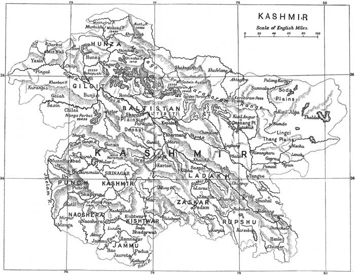
Báramúla, 34·1 N.—74·2 E. Situated at the point where the Jhelam gorge ends and the Vale of Kashmír begins. Travellers who intend to go to Srínagar by water board their house boats here. There is an excellent poplar-lined road from Báramúla to Srínagar and a bad road to Gulmarg.
Chilás, 35·4 N.—74·2 E. See page 323.
Gulmarg, 34·1 N.—74·4 E. S.W. of Srínagar. It is a favourite hot weather resort of Europeans. The Mahárája has a house here. The forest scenery is beautiful, especially on the way to the limit of trees at Khilanmarg. Good golf links on beautiful turf.
Gurais, 34·7 N.—74·8 E. A beautiful valley drained by the head waters of the Kishnganga. It lies between Bandipura and the Burzil Pass on the road to Gilgit.
Hunza, 36·4 N.—74·7 E. (See page 323.) Hunza is a group of villages. The Rajá's (or Tham's) fort, Baltit castle, at an elevation of 7000 feet is splendidly situated in full view of Rakaposhi, distant 20 miles. It is overhung by the enormous mass of snow peaks said to be called in the language of the country Boiohaghurduanasur (the peak of the galloping horse).
Islámábád, 33·4 N.—75·1 E. About 40 miles by river from Srínagar, near the point where the Jhelam ceases to be navigable. Achabal and Mártand are easily visited from Islámábád, and it is the starting point for the Liddar Valley and Pahlgam. It is a dirty insanitary place.
Jammu, 32·4 N.—74·5 E. Capital of the Jammu province and winter residence of the Mahárája. Connected with Siálkot by rail. Situated above the ravine in which the Tawí flows. At a distance the white-washed temples with gilded pinnacles look striking. The town was once much more prosperous than it is to-day.
Leh, 34·2 N.—77·5 E. Capital of Ladákh. On the Indus 11,500 feet above sea-level. The meeting place of caravans from India and Yárkand. The Central Asian caravans arrive in Autumn, when the bazár, in a wide street lined with poplars, becomes busy. The Wazír Wazárat has his headquarters here, and there is a small garrison in the mud fort. The old palace of the Gyalpo (King) is a large pile on a ridge overhanging the town. There are Moravian and Roman Catholic missions at Leh.
Mártand, 33·4 N.—75·1 E. Remains of a remarkable temple of the Sun god three miles east of Islámábád (pages 166 and 201).
Payer (erroneously Payech). Nineteen miles from Srínagar containing a beautiful and well-preserved temple of the Sun god, dated variously from the fifth to the thirteenth century (page 202).
Punch, 33·4 N.—74·9 E. Capital of the jágír of the Rája of Punch, a feudatory of the Kashmír State. 3300 feet above sea level. There is a brisk trade in grain and ghí. Decent roads connect Punch with Ráwalpindí and Urí on the Jhelam. Cart Road into Kashmír. Kashmírís call the place Prunts and its old name was Parnotsa.
Skardo, 35·3 N.—75·6 E. Old capital of Báltistán. 7250 feet above sea-level. In a sandy basin lying on both sides of the Indus, and about five miles in width. A tahsíldár is stationed at Skardo.
Table I. Tribes of Panjáb (including Native States) and N.W.F. Province[1].
Landholding etc. Traders Artizans and menials Impure Castes
Tribe Panjáb p.c. N.W.F.P. p.c. Tribe Panjáb p.c. N.W.F.P. p.c. Tribe Panjáb p.c. N.W.F.P. p.c. Tribe Panjáb p.c. N.W.F.P. p.c.
Rajputs 6.8 .7 Khatrís 1.8 1.2 Chamár[9] 4.7
Arains and Kambohs 4.8 — Banias 1.7 — Juláhas[3] 2.6 1.7
Brahmans 4.2 .6 Jhínwar and Máchhi[4] 2.6 —
Gújars 2.5 5.2 Kumhár[5] 2.3 1.0
Biloch 2.2 1.2 Nai[6] 1.4 1.1
Awán 1.8 12.6 Telí[7] 1.2 .3
Shekhs inc. Kureshí 1.7 —
Kanet 1.7 —
Sainís, Málís, Malliárs 1.3 1.8
Patháns 1.2 38.3
Saiyyíds 1.0 4.4
Table II. Rainfall, Cultivation, Population, and Land Revenue.
Zone District Rainfall in Inches No. of Masonary Wells Cultivated Area Acres 1922-1912 Classes of Cultivation, p.c. Population 1911 Land Revenue in 1911-1912 in hundreds of rupees
Well Canal Abí Total Irrd. Moist Dry Total Unirrd.
Mountain and Submontane Kánga 125 5 587,826 — — 20 20 — 80 80 770,386 9,267
Simla 68 — 9,984 — — 7 7 — 90 94 39,320 175
Ambála 35 2,154 750,515 4 — 2 6 4 90 94 689,970 11,477
Hoshyárpur 36 6,841 722,122 5 2 1 8 — 92 92 918,569 14,225
Total British dts. Panjáb — 9,000 2,070,447 3 1 6½ 10½ 1½ 88 89½ 2,418,245 35,144 (1.10.0)[1]
Hazára (N.W.F.P.) 46 353 430,872 — — 10 10 — 90 90 603,028 5,129 (1.3.1)
Kashmír and Jammu 35[3] — 1,750,056 — — — 32 — — 68 2,893,066 —
Total Kashmír — — 1,872,008 — — — 30 — — 70 3,103,381 —
North Central Panjáb Plain (British Districts) Gujrát 28 10,221 845,023 26 — — 26 6 68 74 784,011 8,445
Siálkot 35 23,010 941,558 54 1 3 58 9 33 42 979,553 14,847
Gurdáspur 35 6,439 844,403 16 11 — 27 14 59 73 836,771 15,410
Amritsar 24 12,386 787,229 31 31 — 62 4 34 38 880,728 12,746
Jalandhar 28 28,289 695,571 44 — — 44 5 51 56 801,920 14,871
Ludhiána 28 9,991 754,373 19 7 — 26 4 70 74 517,192 11,103
Total — 90,336 4,868,157 32 8 1 41 7 52 59 4,800,175 77,422 (1.9.5)
North-West Area Ráwalpíndí 33 947 598,371 ½ — ½ 1 — 99 99 547,827 6,754
Jhelam 26 4,103 754,585 4 — — 4 4 92 96 511,175 7,576
Attock 19 6,850 1,031,962 2½ — 1 3½ 1 96 97 519,273 6,741
Mianwáli 12 7,128 748,255 17 2 — 19 38½ 42½ 81 341,377 4,866
Total Panjáb — 19,028 3,133,173 6 ½ ½ 7 10 83 93 1,919,652 25,937 (0.13.3)
Pesháwar 13 6,597 894,803 5 33 ½ 38½ 2 59½ 61½ 865,009 11,375
Kohát 18 467 327,949 ½ — 12 12½ ½ 87 87½ 222,690 2,755
Bannu 13 11 523,688 — 24 — 24 — 76 76 256,086 3,040
Total N.W.F.P. — 7,075 1,746,440 3 24½ 2½ 30 1 69 70 1,343,785 17,170 (0.15.8)
South-Western Plains Gujránwála 24 10,926 1,179,348 37 40 — 77 4 19 23 923,419 10,497
Lahore 21 13,828 1,462,108 31 43½ 1 75½ 5 19½ 24½ 1,036,158 11,301
Sháhpur 14 6,403 1,267,566 14 55 — 69 6 25 31 648,989 8,701
Jhang 10 11,588 723,733 36 46 — 82 16 2 18 515,526 6,429
Lyallpur 9 121 1,373,892 — 99 — 99 1 — 1 857,711 12,736
Lyallpur 10 10,472 815,355 27 28 1 56 25 19 44 555,219 6,225
Multán 7 20,132 1,081,030 58½ 26 1 85½ 13½ 1 14½ 814,871 15,865
Muzaffargarh 6 14,053 553,643 36 33 4 73 27 — 27 569,461 7,316
Dera Ghází Khán 6 9,564 1,035,011 25½ 16 2½ 42 53½ 2½ 56 499,860 5,752
Total Panjáb districts — 97,087 9,491,686 28 46 1 75 14½ 10½ 25 6,420,814 84,822 (0.14.4)
D.I. Khán N.W.F.P. 8 795 544,746 1 17 8 26 11 63 74 256,120 3,062 (0.9.0)
South-Eastern Plains (British Districts) Karnál 30 7,827 1,148,876 13 21 — 37 6 57 63 799,787 10,833
Delhi[6] — 7,133 555,057 19 18 — 37 6 57 63 657,604 8,563
Gurgaon 26 6,594 988,613 13 10 1 24 3½ 72½ 76 643,177 12,182
Gurgaon 21 2,450 974,200 4½ 30 — 34½ — 65½ 65½ 541,489 9,660
Rohtak 21 2,450 974,200 4½ 30 — 34½ — 65½ 65½ 541,489 9,660
Hissár 16 720 2,691,478 — 11¼ — 11¼ 2¼ 86½ 88¾ 804,809 8,582
Ferozepore 21 7,940 2,248,322 7 40½ — 47½ 2 50½ 52½ 959,657 12,066
Total Panjáb districts — 32,664 8,606,546 7 22½ — 29½ 3½ 67 70½ 4,306,523 61,886 (0.11.6)
Table III. Diagrams relating to Cultivation.
View larger image
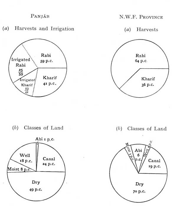
View larger image
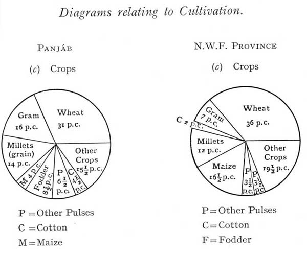
[1] Only tribes amounting in number to 1 p.c. of total population shown.
TABLE IV. Percentages of Principal Crops[1].
Zone District Wheat Barley Rape Toria and Tara Mira Pulses Fodder (both harvests) Maize Millets Rice Cotton Cane Other crops (both harvests)
Gram Other Pulses (both harvests) Bájra Jowár
Mountain and Submontane Zone Kángra 32 7 1 4 4 — 21 — — 15 ½ 1 14½
Simla 31 15 — — 3 — 13 — — 6 — — 32
Ambála 26 2 1 17 9 11 10½ 1½ 1 7 6 2 6
Hoshyárpur 33 1½ 1 17 5 7 17½ ½ 1 4 2 3 7½
Total Panjáb districts 30 3 1 13 6 6 16 ½ ½ 8 3 2 11
Hazára N.W.F.P. 26 10 1 — 1 — 10 1½ 43 1½ 1 — 2
Kashmír and Jammu 21 4 — 7 — 38 — — 9 — — 21
Indus Valley 29 4 — 12 — 7 — — 1 — — 47
Total Kashmír 23 4 — 8 — 35½ — — 8 — — 12½
North Central Panjáb Plain (British Districts) Gujrát 42 4 1 8 7 8 2½ 15 6 1 1½ 1 1
Siálkot 43 6 1 3 5 15 8 1½ 1½ 6½ 2 4 3½
Gurdáspur 36 4 1 7 13 11 8 ½ ½ 6½ 1 7 4½
Amritsar 36 2 3 16 3 20 5 — — 4½ 4 3 3½
Jalandhar 33 1 — 15 7 23 10 — — — 3½ 3½ 4
Ludhiána 28 2 2 3 8 11 7 ½ 3 — 2 2 12
Total 37 3 1 11 18 14 7 3 2 3 2½ 3½ 4½
North-West Area Ráwalpindí 41 2 1 1 19 2½ 8 17 4 — 1 — 3½
Jhelam 47 2 2 3 10 5 1 21 2 — 1 — 5
Attock 50 2 2 9 7½ 2½ 2½ 19 2½ — 1 — 3½
Mianwálí 34 4 3 19 10 2 — 19 4 — ½ — 4½
Total Panjáb Districts 43 2 2 7 11 3½ 3 19 3 — 1½ — 5
Pesháwar 36½ 16 1 1 3 7 18½ 1 4½ 1½ 4 3 3
Kohát 43 2½ 1 5 4 2 8 27½ 2 1 1 — 3
Bannu 49 4 — 24 ½ 4 8 3 1¼ ½ ½ 1¼ 4
Total N.W.F.P. 41 10 1 8½ 2½ 5 13½ 6 3 1 2½ 2 4
South-Western Plains Gujránwála 40 3 4 15½ 3 12 2½ 2½ 3 5 5 2½ 2
Lahore 37 1 6 16 1 15 4½ 1 1 2½ 9 1 5
Shahpur 44 1 7 7 3 10 2 10 3½ 1 8 ½ 3
Jhang 47 1 2 4½ 4 10 2 2 8 ½ 5½ — 13½
Lyallpur 42½ ½ 13 8 2½ 5 4½ ½ 1 — 9 2½ 11
Montgomery 41 1½ 2 13 4½ 17 3 1 2 3 5 — 7
Multán 41 1 2 4 6 13 ½ 4 8 3 9 — 8½
Muzaffargarh 44½ 3 2 8 10 7 — 3 2 7 6 1 6½
Dera Ghází Khán 27 1 10 3½ 5½ 5 — 9 23 8 6 — 2
Dera Ghází Khán 27 1 10 3½ 5½ 5 — 9 23 8 6 — 2
Total Panjáb 40½ 1½ 6 9 4 10 2 3½ 4 3 7 1 8½
D.I. Khán N.W.F.P. 31 2 13 8 3 ½ — 22 9 — 2 — 9½
South-Eastern Plains (British Districts) Ráwalpindí 41 2 1 1 19 2½ 8 17 4 — 1 — 3½
Karnál 21 2 5 26½ 4½ 6½ 5½ 5 11½ 4 6 2 ½
Rohtak 8 2½ 1 34½ 7 2 — 21 14 — 6½ 2 1½
Gurgáon 8 13 1½ 20 12 4 — 25 5 — 8 ½ 3
Hissar 4 7 4 28 8 4 — 26 6½ — 3 — 9½
Ferozepore 28 7 4 31½ 4 8 2½ 3 6 — — — 6
Total Panjáb districts 14 6 3 28½ 7 5 1½ 15 8 ½ 3½ ½ 7½
Grand total Panjáb 31 3½ 4 16 6½ 8½ 4 9 5 2½ 4½ 1½ 4
Grand total N.W.F.P. 36 8½ 3 7 3½ 3½ 16½ 8 4 1 2 1 6
Table V Revenue and Expenditure, 1911-12.
Heads Income Expenditure
Total in Rs. 000 Provincial Total in Rs. 000 Provincial
Share Amount in Rs. 000 Share Amount in Rs. 000
Land Revenue 3,47,92 Half 1,73,96 47,76 Whole 47,76
Stamps 52,57 Half 26,29 1,77 Half 89
Excise 64,00 Half 32,00 1,71 Half 86
Income-tax 16,22 Half 8,11 11 Half 5
Forests 13,10 Whole 13,10 7,64 Whole 7,65
Registration 3,16 Whole 3,16 1,20 Whole 1,20
General Administration — — — 18,33 Various 13,65
Law and Justice —Courts 4,35 Whole 4,35 42,18 Whole 42,18
Law and Justice —Jails 3,41 Whole 3,41 12,24 Whole 12,24
Police 1,80 Whole 1,80 58,57 Whole 58,57
Education 3,64 Whole 3,64 23,27 Whole 23,27
Irrigation— Major Works 2,13,08 Half 1,06,54 1,36,42 Half 68,21
Irrigation— Minor Works 7,99 Various 56 11,17 Various 1,07
Civil Works 6,93 Various 6,20 67,90 Various 62,70
Medical 6,93 — — — Whole 21,20
All other heads[1] 27,60 Nil and various 16,21 56,96 Whole various and nil 41,29
Total 8,03,93 — 3,99,33 5,13,25 — 4,02,79
View larger image
View larger image