NATIONAL GEOGRAPHIC MAGAZINE.
Reading edition
Vol. II. 1890. No. 2.
THE RIVERS OF NORTHERN NEW JERSEY, WITH NOTES ON THE CLASSIFICATION OF RIVERS IN GENERAL.
BY WILLIAM MORRIS DAVIS.
OUTLINE.—Rivers of different kinds: consequent, antecedent, superimposed, subsequent, adjusted.—Topography of Northern New Jersey.—Revived and superimposed rivers in New Jersey.—Drainage of the Watchung crescent.—Re-arrangement of superimposed rivers by the growth of subsequent streams.—Application of this principle to the Green river in the Uinta mountains: Powell's and Emmons' theories.—The Green river probably superimposed and its branches re-arranged by the growth of subsequent streams.—Anaclinal and reversed rivers in New Jersey.
Northern New Jersey is drained by several streams which rise in the Archean Highlands, flow southeastward across the central Triassic plain and reach the sea near the inland margin of the Cretaceous formation.
What kinds of rivers are these? Such a question can hardly be answered until we have examined rivers in many parts of the world, gaining material for a general history of rivers by induction from as large as possible a variety of examples; and until we have deduced from our generalizations a series of critical features sufficient to serve for the detection of rivers of different kinds wherever found.
The generalizations here referred to may be presented in the form of a classification, following the ideas of Powell, Gilbert, Heim, Löwl and others, as follows:
Consequent rivers.—Those that have in their birth, at the time of their original establishment on the country which they drain, selected courses in accordance with the constructional slopes of the surface; for example, the Red River of the North and such of its branches as flow on the even surface of the lacustrine plain of Lake Agassiz; the several streams that drain the broken lava blocks of Southern Oregon; certain streams and rivers of the Jura that drain the synclinal troughs of those mountains. Consequent streams may be divided into definite and indefinite groups. Definite consequent streams are those that follow well defined constructional channels, such as the axial line of a synclinal trough, or the lowest point of an anticlinal arch between two synclinal basins; they are defined in location as well as in direction. Indefinite consequent streams are those that flow down constructional slopes, such as the flanks of an anticline, but whose precise location depends on those minor inequalities of surface that we term accidental; they are defined in direction but not in location; and they are as a rule branches of definite consequent streams.
Antecedent rivers.—Those that during and for a time after a disturbance of their drainage area maintain the courses that they had taken before the disturbance. In Powell's original definition of this class of rivers, he said that the valleys of the Uinta mountains are occupied by "drainage that was established antecedent to the corrugation or displacement of the beds by faulting or folding."1 No limit is set to the amount of corrugation or displacement or to the strength of the faulting or folding. It therefore seems advisable to consider what variations there may be from the strongly marked antecedent type; one extreme being in those cases where the displacement was a minimum and the perseverance of the streams a maximum, the other where the displacement was a maximum and the successful perseverance of the streams a minimum, or zero. The simplest examples of antecedent rivers are therefore found in regions that have been broadly elevated with the gentlest changes of slope, so as to enter a new cycle of topographic development, all the streams retaining their previous courses, but gaining ability to deepen their former channels down to the new baselevel; such streams may be called "revived." Examples of revived streams are very common; nearly all the streams of the Highlands of New Jersey are of this kind; all the streams of central and western Pennsylvania seem to belong in the same class. From these simple and common examples, we shall some day, when our knowledge of rivers is better developed, be able to form a complete series leading to what is generally understood as the typical antecedent river, which has outlived deformation as well as elevation without suffering either deflection or ponding. Large rivers of strong slope, well enclosed in steep-sided valleys, or in other words vigorous adolescent rivers have the best opportunity to persist across a belt of rising or writhing country,2 because a great deformation would be required to throw them from their courses. Small streams or large ones of faint slope in an open low country are more easily deflected. From the typical antecedent river, the series may be continued by examples in which even the larger streams are less or more ponded or deflected by the deformation, until at the end of the series there is a complete extinction of the antecedent drainage and the establishment of an entirely original consequent drainage. The perfectly typical antecedent river, in the middle of this series, is certainly of rare occurrence, and is perhaps unknown.
1 Colorado river of the West, 163.
2 Stur's expression "Gebirgshub oder Gebirgschub" suggested to me the terms here employed.
Consequent streams, whose course is taken on a relatively thin, unconformably overlying mass, for a time preserve their initial courses, even though they may be quite out of accord with the underlying structures on which they have descended. Such streams were first recognized by Marvine, and afterwards named "superimposed," "inherited" or "epigenetic" by various authors. A full collection of examples of this class should begin with streams that depart from true consequent courses only locally, where they have discovered a small portion of the underlying formation, like the Merrimack at Manchester and other water-power towns of New Hampshire, where the stream has sunk upon rocky ledges beneath the surface drift and sands; or like the Mississippi and other rivers in Minnesota which have in places cut through the drift sheet to the underlying crystallines. The series would conclude with streams that have stripped off the cover on which they were consequent, and have thus become superimposed on the underlying formation in their whole length.
There is a curious intermediate type of drainage lately recognized by McGee in the southern states, a superimposed drainage that is not inconsequent upon the buried surface beneath the unconformably overlying surface layer. It occurs in regions where a well-marked drainage had been established; a brief submergence then allowed the deposition of a relatively thin mask of sediments; an elevation brought the masked surface up again, and as it rose, the streams took possession of lines essentially identical with the courses of their ancestors, because the mask of newer deposits had not extinguished the antecedent topography. McGee proposes to call such streams "resurrected."
Rivers of all classes as a rule develop during their adolescence and more mature growth certain "subsequent" branches that were not in any way represented in the early youth of the system. Thus the indefinite members of the consequent drainage of the Jura mountains have developed subsequent streams on soft beds of monoclinal and anticlinal structures, where there could not possibly have been any consequent drainage lines at the birth of this system, unless we admit the supposed fracturing of the anticlinal crests, which seems unnecessary to say the least. Even in the simplest style of drainage, growing on a level surface, many of the branches must be "subsequent," or as McGee has called them in such cases, "autogenetic."
Rivers of all classes are subject to spontaneous re-arrangement or adjustment of their courses to a greater or less extent, in accordance with the weaker structural lines. This results from the migration of divides and the consequent abstraction or capture of one stream by another. The capture is generally made by the headward development of some subsequent branch. But after this kind of change has advanced to a certain extent, the divides become stable, and further change ceases. The rivers may then be said to be maturely adjusted. Under certain conditions, chiefly great initial altitude of surface, and great diversity of structure, that is, in mountainous regions, the changes arising from adjustments of this spontaneous kind are very great, so that the courses of a river's middle age may have little resemblance to those of its youth, as Löwl has pointed out and as I have tried to show in the case of the Pennsylvanian rivers. It may be difficult to recognize in such cases whether the youthful courses of a river system were consequent, antecedent or superimposed. Adjustments of this kind were not discussed by Powell, although he makes brief mention of what I have called subsequent streams. The first appreciation that I gained of river adjustments came from the writings of Löwl; but I have since found that the general principles governing their opportunity were stated by Gilbert in his monograph on the Henry Mountains of Utah (pp. 141, 149), and by Heim in his Mechanismus der Gebirgsbildung (i, 272, etc., ii, 79, 320).
Where do the rivers of northern New Jersey stand in this general scheme of river classification? We must again postpone the answer to the question, while reviewing the history of the general geographical development of the region.3
3 The more detailed statement of this history may be found in an essay prepared by the author with the collaboration of Mr. J. W. Wood, Jr., of the class of 1888 in Harvard College, the study being undertaken as a joint thesis by instructor and student in a second course in Physical Geography. The essay is published in the Proceedings of the Boston Society of Natural History, 1889.
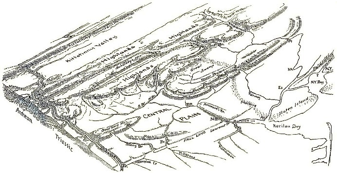
FIG. 1.
The topography of northern New Jersey may be briefly described as made up of valleys and lowlands that have been etched in the now elevated surface of what may be called the Schooley peneplain on the Cretaceous baselevel. The topographical atlas of New Jersey should be constantly referred to, in order to follow such a statement as this; but in order that the reader may without undue difficulty apprehend the meaning of my descriptions and recognize the various localities yet to be named without the trouble of searching for them on the maps of the atlas, I have attempted to draw a generalized bird's eye view of northern New Jersey, as it would be seen by an observer about seventy miles vertically above the center of southern New Jersey. The meridians are vertical and east and west lines are horizontal, but oblique azimuths are foreshortened. The result is hardly more than a geographical caricature, and I publish it in part to experiment upon the usefulness of so imperfect an effort. An active imagination may perceive the long even crest line of Kittatinny Mountain on the northwest, rising beyond the rolling floor of the Kittatinny Valley, as the great Alleghany limestone lowland is here called; then come the Highland plateaus, of accordant altitude one with another, but without the mesa-like margin that my pen has not known how to avoid indicating. The Central plain lies in the foreground, diversified by the various trap ridges that rise above its surface; First and Second mountains of the double Watchung crescent near the Highlands; Sourland Mountain in the southwest; and Rocky Hill, the southwestern re-appearance of the Palisades intrusive trap sheet, lying a little nearer to us. The Central plain is also diversified by the Fall-line, a slight but rather distinct break in its surface from Trenton (Tr.) on the Delaware to a little below New Brunswick (N. B.) on the Raritan. The important drainage lines are: the Delaware, forming the western boundary of the State, trenching Kittatinny Mountain at the Water Gap, cutting a deep transverse valley through the Highlands where it receives longitudinal branches, and a shallower trench across the Kittatinny lowland and the Central plain; the Raritan, whose north and south branches head in the Highlands, while the Millstone joins it from south of the fall-line, cutting through Rocky Hill near Princeton (Pr.) on the way; and the Pequannock-Passaic, rising in the Highlands, gathering tributaries in the low basin behind the Watchung ridges, and escaping to the front country as a single stream, the Passaic, through deep gaps at Patterson. The terminal moraine, marking the furthest advance of the second glacial invasion of post-tertiary time, is indicated by an irregular dotted band crossing the State, from the Narrows of New York Bay, which it defines, on the east, passing over Second Mountain by the gap at Summit (S), rising midway in the Highlands over Schooley Mountain, and traversed by the Delaware at Belvidere (B).
The Schooley peneplain is indicated by the crest and summit altitudes of Kittatinny Mountain, the Highland plateaus and the trap ridges. This peneplain once lay low and essentially horizontal, the practically completed work of the processes of denudation acting on a previously high land through a long period of time: it is now lifted and tilted, so that its inland portion rises to the height of the Highlands, which are its remnants, while its seaward portion descends slowly beneath a cover of unconformable Cretaceous beds, southeast of the fall-line, and thus hidden sinks gently beneath the Atlantic shore. The cover of Cretaceous sediments was laid on the southeastern part of the old peneplain during a moderate submergence of its seaward portion, before the elevation and tilting above mentioned (fig. 2, p. 93). Much of the cover has been worn away since the time of elevation (figs. 3-6, p. 95), which gave opportunity for the opening of deep valleys on the soft limestones and slates among the hard crystalline rocks of the Highlands; and for the production of the broad Kittatinny Valley lowland or peneplain on the wide belt of limestones beyond the Highlands; and furthermore for the development of a broad baselevelled plain on the weak Triassic shales and sandstones, where the old peneplain has been almost entirely destroyed. The Cretaceous cover remains only near the coast, where it stood too low to be attacked while the valleys and lowlands just described were carved out. An interesting peculiarity in the relation between the newer baselevel plain on the Triassic area and the old Cretaceous peneplain is that their surfaces mutually intersect at a small angle along the line which now marks the visible contact between the Triassic and Cretaceous formations: the newer plain standing beneath the eroded portion of the older one northwest of this line, while it rises above the buried part of the older one and obliquely truncates its Cretaceous cover to the southeast of the line. Finally, the land as a whole has been raised a little since the making of the newer plain, and shallow valleys interrupt its broad surface. It is no longer a true plain; it has become a pastplain. A few words may be allowed me concerning these terms, peneplain and pastplain. Given sufficient time for the action of denuding forces on a mass of land standing fixed with reference to a constant baselevel, and it must be worn down so low and so smooth, that it would fully deserve the name of plain. But it is very unusual for a mass of land to maintain a fixed position as long as is here assumed. Many instances might be quoted of regions which have stood still so long that their surface is almost reduced to its ultimate form; but the truly ultimate stage is seldom reached. We can select regions in which the valley lowlands have become broad and flat, the intermediate "doab" hills have wasted away lower and lower until they are reduced to forms of insignificant relief; and yet the surface still does not deserve the name of plain as unqualifiedly as do those young lands newly born from seas or lakes in which their geometrically level surfaces were formed. I have therefore elsewhere suggested4 that an old region, nearly baselevelled, should be called an almost-plain; that is, a peneplain.
4 Amer. Jour. Sci., xxxvii, 1889, 430.
On the other hand, an old baselevelled region, either a peneplain or a truly ultimate plain, will, when thrown by elevation into a new cycle of development, depart by greater and greater degrees from its simple featureless form, as young narrow valleys are sunk beneath its surface by its revived streams. It therefore no longer fully deserves the name that was properly applicable before its elevation. It must not again be called a peneplain, for it is now not approaching and almost attaining a smooth surface, but is becoming rougher and rougher. It has passed beyond the stage of minimum relief, and this significant fact deserves implication, at least, in a name. I would therefore call such a region a pastplain. The area of the weak Triassic shales was, until its late elevation, as good an example of an ultimate baselevelled plain as any that I have found; but now it is a pastplain, as any one may see while traveling across it on the train: its doabs are broad and continuous, and its valleys are relatively narrow and shallow. The Kittatinny lowland is intersected by streams whose valleys sink below its generally even, gently rolling surface; but it was never so smooth as the Triassic plain. It was only a peneplain, and it is now a roughened peneplain. Perhaps the more adventurous terminologist will call it a past-peneplain; but I dare not venture quite so far as that. When the Highlands were lowlands, their surface well deserved the name of peneplain; but they were lifted so long ago into so high a position that they are now cut into a complicated mass of rugged uplands. They no longer deserve the name of peneplain; and if in preceding paragraphs I have referred to them as constituting an old peneplain, it is because no satisfactory name has yet been applied to the particular stage of development of plains and plateaus in which they now stand. Having tried in vain to invent a term with which to name the Highlands, let me now advertise for one in the pages of our Magazine.
WANTED: a name applicable to those broken, rugged regions that have been developed by the normal processes of denudation from the once continuous surface of a plain or peneplain. The name should be if possible homologous with the words, plain, peneplain and pastplain; it should be of simple, convenient and euphonious form; it must be satisfactory to many other persons than its inventor; and its etymological construction should not be embarrassed by the attempt to crowd too much meaning into it. The mere suggestion that it was once a plain and that it is now maturely diversified will suffice.
The topography of northern New Jersey is therefore, like its structure, polygenetic. It exhibits very clearly a series of forms developed under three different geographic cycles, and closer search will doubtless discover forms belonging to yet other cycles, less complete and of briefer duration than these three. There is the tilted and deeply eroded peneplain of the Highlands, whose initial form may be called the Schooley peneplain, from the distinct exhibition of one of its remnants on Schooley's mountain; this was the product of Jurassic and Cretaceous denudation. There is the younger central baselevelled plain, developed during Tertiary time, or thereabouts, on the weaker Triassic and Cretaceous beds; and the associated valleys of the same age that have been sunk into the weakest rocks of the Highlands. There are the shallow valleys in the Central plain, of the latest post-tertiary cycle, requiring the name of this region to be changed from plain, as it was lately, to pastplain, as it is now. The first cycle, in which the Schooley peneplain was produced, witnessed the accomplishment of a great work; it included in its later part, besides various other oscillations, the sub-cycle when the seaward or southeastern part of the peneplain was gently submerged and buried to a slight depth under Cretaceous deposits. The second cycle was shorter; being a time sufficient to baselevel the softer beds, but not seriously to consume the harder parts of the pre-existing surface. We are still in the third cycle, of which but a small part has elapsed. The question with which this essay opened may now be taken up.
The streams and rivers of northern New Jersey may be examined, with the intention of classifying them according to their conditions of origin, to their degree of complexity as indicated by the number of geographic cycles through which they have lived, and to the advance made toward their mature adjustment.
The Musconetcong may be taken as the type of the Highland streams. It flows southwestward along a narrow limestone valley between crystalline plateaus on either side, entering the Delaware a little below Easton, Pa., (E, fig. 1). It drains a country that has been enormously denuded, and during the Jura-Cretaceous cycle of this deep denudation, there must have been time for it and its fellows to become thoroughly adjusted to the structure of the region; it must be chiefly for this reason that it flows so closely along the weak limestone belt, and has its divides close by on the adjoining harder crystallines, (M, fig. 2). Whatever its origin, it has lost every initial feature that was discordant with the deep structures that it discovered beneath the initial surface; it is maturely adjusted to its environment. It endured to an old age during the baselevelling of the Schooley peneplain, and is now a "revived" stream, in at least its second cycle of work. Most of the other streams of the Highlands and the country farther inland are also of this well adjusted, revived kind. The streams of the Kittatinny valley lowland show not only the first revival of the kind just described, but also a second revival, in consequence of the recent uplift that has introduced the third cycle of development; this not being so clearly manifested in the Highlands, where the rocks are harder, and the valleys of the second cycle are narrower.
Look now at the drainage of the crescentic Watchung mountains; the curved edges of two great warped lava-flows of the Triassic belt. The noteworthy feature of this district is that the small streams in the southern part of the crescent rise on the back slope of the inner mountain and cut gaps in both mountains in order to reach the outer part of the Central Plain. If these streams were descended directly or by revival from ancestors antecedent to or consequent upon the monoclinal tilting of the Triassic formation, they could not possibly, in the long time and deep denudation that the region has endured, have down to the present time maintained courses so little adjusted to the structure of their basins. In so long a time as has elapsed since the tilting of the Triassic formation, the divides would have taken their places on the crest of the trap ridges and not behind the crest on the back slope. They cannot be subsequent streams, for such could not have pushed their sources headwards through a hard trap ridge. Subsequent streams are developed in accordance with structural details, not in violation of them. Their courses must have been taken not long ago, else they must surely have lost their heads back of the second mountain; some piratical subsequent branch of a larger transverse stream, like the Passaic, would have beheaded them.
The only method now known by which these several doubly transverse streams could have been established in the not too distant past, is by superimposition from the Cretaceous cover that was laid upon the old Schooley peneplain. It has already been stated that when the Highlands and this region together had been nearly baselevelled, the coastal portion of the resulting peneplain was submerged and buried by an unconformable cover of waste derived from the non-submerged portion: hence when the whole area was lifted to something like its present height, a new system of consequent streams was born on the revealed sea bottom. Since then, time enough may have passed to allow the streams to sink their channels through the unconformable cover and strip it off, and thus superimpose themselves on the Triassic rocks below: we should therefore find them, in so far as they have not yet been re-adjusted, following inconsequent, discordant courses on the under formation. The existing overlap of the Cretaceous beds on the still buried Triassic portion of the old Schooley peneplain makes it evident that such an origin for the Watchung streams is possible; but it has not yet been independently proved that the Cretaceous cover ever reached so far inland as to cross the Watchung ridges.
Want of other explanation for the Watchung streams is not satisfactory evidence in favor of the explanation here suggested. There should be external evidence that the Triassic area has actually been submerged and buried after it was baselevelled to the Schooley peneplain and before it was uplifted to its present altitude; other streams as well as the ones thus far indicated, should bear signs of superimposition; and if adjustment of the superimposed courses has begun, it should be systematically carried farthest near the largest streams. I shall not here state more than in brief form, the sufficient evidence that can be quoted in favor of the first and second requisites. Suffice it to say that the overlap of the Cretaceous beds (which contain practically no Triassic fragments) on the bevelled Triassic strata at Amboy and elsewhere indicates submergence after baselevelling; and that the pebbles, sands and marls of the Cretaceous series point clearly to the Highlands as their source. The submergence must therefore have reached inland across the Triassic formation at least to the margin of the crystalline rocks. Some shore-line cutting must have been done at the margin of the Highlands during Cretaceous time, but the generally rolling surface of the old peneplain leads me to ascribe its origin chiefly to subaërial wasting. Moreover, the North Branch of the Raritan, between Mendham and Peapack (* Fig. 1) and the Lockatong (L), a small branch of the Delaware on the West Hunterdon sandstone plateau, give striking indications of superimposition in the discordance of their courses with the weaker structural lines of their basins, so unlike the thoroughly adjusted course of the Musconetcong and its fellows, the Pohatcong, the Lopatcong, and others.
The third requisite of the proof of the inland extension of the Cretaceous, and the resulting superimposed origin of the Watchung streams may be stated in detail, as being more in the line of this essay: has the adjustment that accompanies superimposition systematically advanced farther near the large streams than near the small ones? The character of this adjustment should be first examined deductively. Given a series of streams of different volumes, flowing southeastward, in the direction of the present dip of the remnant of the Cretaceous cover, over the former inland extension of this superposed formation; how will these streams react on one another when they sink their channels into the underlying Triassic formation?
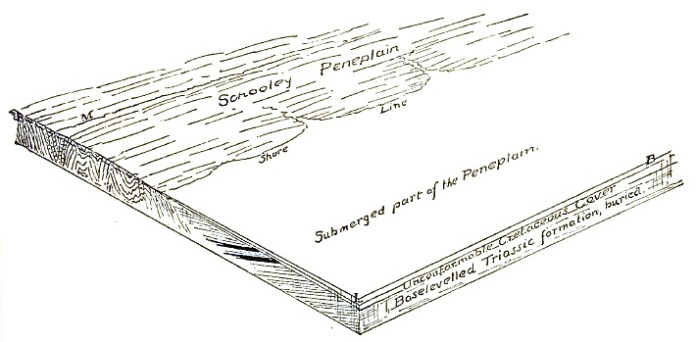
FIG. 2.
The conditions during the formation of the cover of Cretaceous beds are illustrated in fig. 2, where the Triassic portion of the peneplain is submerged, and the shore-line of the transgressing ocean has reached the margin of the crystalline rocks. The waste from the crystallines is spread out as a series of gravels, sands and marls on the baselevelled Triassic area.
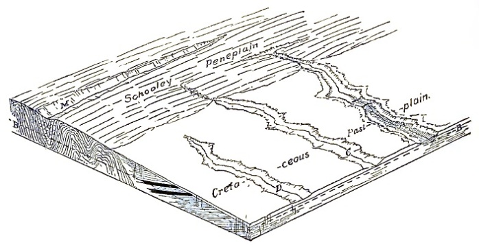
FIG. 3.
Then follows the elevation and tilting of the peneplain with the cover on its back; and with this regression of the sea, there is an equivalent gain of new land; a smooth gently sloping plain is revealed as the shore line retreats; streams run out across it from the crystalline area, or begin on its open surface, growing mouthward as the land rises. Three such streams, A, C, D, are shown in fig. 3; their opportunity for deep valley-cutting is indicated by the depth of the new baselevel, BL, below the general surface of the country. While these streams are deepening their channels in the Cretaceous cover, which is unshaded with marginal contour lines in the figures, their subsequent, autogenetic branches are irregularly disposed, because there is no lateral variation of structure to guide them; but after a time, the baselevelled surface of the buried Triassic beds is reached, as is shown by linear shading in the valley bottoms of figs. 4, 5, 6, 7. The growth of the subsequent branches then developed, will be along the strike of the Triassic softer beds, that is, about square to the course of the three transverse streams under consideration. The most rapid growth will be found on the branches of the largest stream, A, because it will most quickly cut down its channel close to the baselevel of the time and thus provide steep sloping valley-sides, from which the subsequent branches cut backwards most energetically. In due time the main streams discover the particularly resistant transverse lava sheets in the underlying formation; and then the subsequent branches of the largest transverse stream on the up-stream side of the obstructions, for example, F and G, fig. 4, will have a great advantage over those of the smaller streams. The most rapidly growing subsequent branch, G, fig. 5, of the largest transverse master stream, A, may grow headwards so fast as to push away the divide, X, which separates it from the head of the opposing subsequent branch, J, of the next adjacent smaller transverse stream, C, and thus finally to capture and divert the headwaters, H, of the smaller transverse stream to the larger one, as in fig. 6. The divide creeps while the two opposing subsequent branches are in contest; it leaps when the successful subsequent branch reaches the channel of the conquered stream. The first stream captured in this way must necessarily be the nearest to the large stream. The diversion of the considerable volume of headwaters, H, to the channel of the small subsequent branch, G, causes it to deepen its channel rapidly; the same effect is perceptible in H for a distance above its point of capture and diversion: the increased load of sediment thus given to G will be in great part dropped in a fan-delta where it enters the flat valley of the master stream, A, (fig. 6).
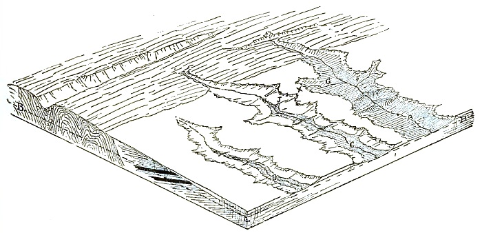
FIG. 4.
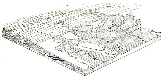
FIG. 5.
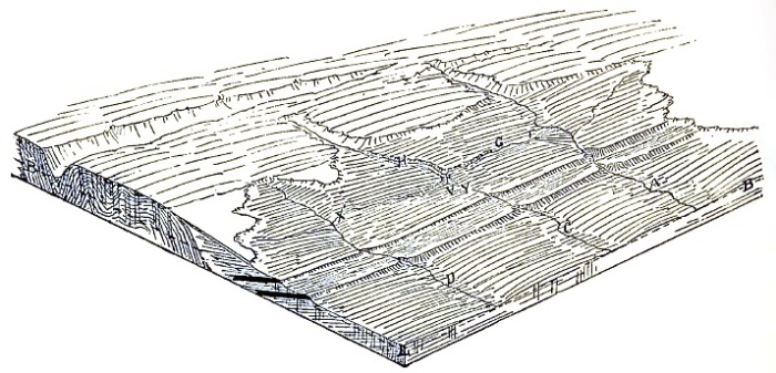
FIG. 6.
Gaining strength by conquest, other captures are made, faster for a time, but with decreasing slowness as the head of the diverting subsequent branch recedes from the original master: and at last, equilibrium may be gained when the headwater slope of the diverting branch is no greater than that of the opposing subsequent branch of the next uncaptured transverse stream. After the capture of a transverse stream has been effected in this way, the divide, Y, between its diverted upper portions, H, fig. 6, and its beheaded lower portion, C, will be pushed down stream by the growth of an inverted stream, V. This goes on until equilibrium is attained and further shifting is prevented on reaching the hard transverse lava sheets, Z, fig. 7; here the divide is maturely established. In the case of a system of transverse streams, C, D, etc., fig. 7, successively captured by the subsequent branch of a single master, the divides (Z, Y'), between the inverted (V, V') and beheaded (C, D) portions of the captured streams will for a time present different stages of approach to establishment. The divide on the line of that one of the original streams, C, that is nearest to the master stream, A, may reach a final stable position, Z; while on the next stream further away from the master, the beheaded portion, D, may still retain a short piece above the gap in the upper lava sheet, not yet secured by the inverted stream, V'; and a third stream, further away still from the master (not shown in figure 7) might remain uncaptured and independent.
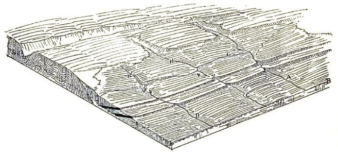
FIG. 7.
It is by such tests as these that we may hope to recognize the occurrence of partial adjustment in the streams of the Watchung crescent as a result of their superimposition on the Triassic formation from its former Cretaceous cover. The greater the degree of complexity in the tests proposed, the more confidence we shall have in the theory when the tests successfully meet the facts. Hence the reason for deductively carrying out the theoretical conditions to their extremest consequences in order to increase the complexity of the tests that are to be confronted with the facts. This, as a matter of method, seems to me of great practical importance in any attempt to decipher the past progress of geographical development.
The admirable contoured topographic maps of New Jersey, issued by the Geological Survey of that state under the leadership of the late Professor George H. Cook, afforded means of applying the deductive tests above outlined without the necessity of plodding over all the country concerned; but however good the maps are, it is hardly necessary to say that they can be interpreted with a better appreciation of the facts that they represent after an excursion on the ground has given the student some personal acquaintance with it. This I have tried to gain on various occasions, maps in hand.
Atlas sheet number six, including the Central red-sandstone area, and the five-mile-to-an-inch geological map of the state present in the clearest manner the facts of form and structure involved in our problem; and to my mind, the correspondence between theory and fact is very striking. The Pequannock-Passaic is the master transverse stream of the region: its preëminence was probably due in the beginning to its gathering, from the unsubmerged Highlands, a greater amount of drainage than belonged to any other stream that ran southeastward down the gentle slope of the newly revealed Cretaceous cover. It was at that time a compound, composite river:5 compound because it drained areas of different ages; composite, because these areas were of different structures. Existing examples of compound, composite rivers are seen in the Catawba, the Yadkin-Pedee, the Cape Fear and the Neuse rivers of North Carolina, which all rise on the inland crystalline area, and traverse the coastal quaternary plain before reaching the sea. But unlike these, there must have been, when the old submerged land rose with the Cretaceous cover on its back, numerous small streams whose drainage area lay entirely within the Cretaceous plain. These were simple streams, flowing over a structure of one kind and one age. Their modern homologues are seen in the Maurice, the Great and Little Egg Harbor and the Wading rivers of southern New Jersey, and I suppose also in various relatively short streams of North Carolina, such as the Lumber, Great Cohera and Moccassin.
5 See terminology suggested by the author. Nat. Geogr. Mag., i, 1889, 218.
It cannot be supposed that the original Pequannock-Passaic possessed the large southern branch, which I shall call the upper Passaic, by which Great Swamp is now drained;6 for had this been the case, the divides between the branches of the upper Passaic and the heads of the small streams that now still cross both of the trap ridges, must have long ago been driven to a stable position on the crest line of the inner ridge. The upper Passaic member of the Pequannock-Passaic system must be regarded as a branch of subsequent development, guided by some of the softer Triassic beds when they were reached beneath the Cretaceous cover, and very successful in capturing and diverting other transverse streams that were smaller than its master. For some distance on either side from the Pequannock-Passaic gap in the trap ridges at Patterson, the existing streams are perfectly adjusted to the Triassic structure; that is, the ridges are persistent divides, and the lateral subsequent branches of the master flow along the strike of the softer shales and sandstones, except where lately thrown off their courses by glacial drift barriers. This I interpret as meaning that the Pequannock-Passaic master stream hereabouts made so early a capture of adjacent superimposed streams that all traces of their initial discordant courses have been obliterated by the development of structurally accordant subsequent streams.
6 It should be recognized that the present round-about drainage of the Great Swamp is a post-glacial feature, determined by the morainic barrier that crosses the basin from Summit (S) to Morristown (M): the pre-glacial drainage of the southern part of the inner crescent was undoubtedly of a simpler and more direct pattern.
The Watchung ridges extend only about eight miles northward of the Paterson gaps, but reach thirty miles southwestward. It is therefore chiefly in the latter direction that we may expect to find examples of incomplete adjustment following superimposition and capture. At Milburn, there is a deep gap in First mountain, and opposite this at Summit (S, fig. 1) a partly drift-filled gap in Second mountain: this I am disposed to regard as the former outlet of the Rockaway-Rahway river, which on account of its considerable size was not captured by the Passaic until it had cut its passage across the trap sheets almost to a safe depth. The diverted upper portion—the Rockaway—now joins the Passaic; its crooked course from the Highlands via Boonton (Bn) being a post-glacial irregularity; the beheaded lower portion—the Rahway—heads on the ridge of Second mountain, retains the pair of subsequent streams between the two ridges, and flows in diminished volume to the sea: the divide between the two portions being in its mature stable position on Second mountain.
South of the Milburn gap, there are three streams that maintain water gaps in First mountain, and five head branches of these three streams rise behind the crest of Second mountain. These must be interpreted as remnants of streams that once rose further inland, and whose upper courses have been captured by the victorious upper Passaic; but it is noteworthy that here, at the greatest distance from the gap of the master stream at Paterson, the divides between the diverted and beheaded portions of these southern streams should lie in unstable positions, back of the crest line of Second mountain. This is exactly what the hypothesis of a superimposed origin for these streams would require; and if the complexity of accordance between deduction and fact here presented be duly considered, I believe new confidence may be gained in the hypothesis of superimposition, already rendered likely from other evidence.
The rectangular courses of the streams that cross First and Second mountains southwest of Milburn do not militate against their initial obliquely superimposed courses; for, as Gilbert has shown, oblique courses across tilted beds, alternately hard and soft, will gradually shift until they follow rectangular courses, along the strike of the soft beds and square across the strike of the hard beds. Middle Brook, at the southern bend of First mountain near Bound Brook (B, B), presents the peculiarity of branching east and west while on the trap sheet of the mountain: this may be due to a retention here, where the dip is moderate, of an initially superimposed bifurcation; or to guidance by fractures at this point where the course of the mountain changes rather abruptly; the facts at hand do not serve to make choice between these alternatives.
The lesson of greatest importance in this study lies, to my mind, in the gradual development of accordant subsequent streams in a region where the unchanged superimposed drainage would show no such accordance. Similar adjustment of subsequent streams to structural features may characterize drainage systems that were originally antecedent: and with this principle in mind, I have recently read over with renewed interest Powell's classic study of the Green river where it crosses the Uinta mountains.7 The Green river and the smaller streams of its lateral cañons and valleys are all regarded as antecedent. Let us examine the arguments on which this conclusion rests.
7 Exploration of the Colorado river of the west, Washington, 1875, 152-166. See also the geological map in the Geology of the Uinta mountains, 1876.
The Green river itself rises many miles north of the Uinta range, traverses a relatively low basin before reaching the flank of the mountains, and then instead of turning away, it boldly enters the great uplift and trenches it from side to side in a profound cañon, flowing out to the southwest on its way to the Colorado. There is relatively low ground at the eastern end of the range, several thousand feet lower than the summits of the range on either side of the Green river cañon, and many thousand feet lower than the restored crest of the great uplift; but the river does not follow this open round-about course. Powell says that the river cut through, instead of running around, the great obstruction, because it "had the right of way; ... it was running ere the mountains were formed." Had the mountain fold been formed suddenly, it would have turned the river around it to the east; "but the emergence of the fold above the general surface of the country was little or no faster than the progress of the corrasion of the channel." ... "The river preserved its level, but the mountains were lifted up.... The river was the saw which cut the mountains in two" (152, 153). If this interpretation is correct, the Green river would be the type of a perfect antecedent stream: but it appears to me that the case is probably overstated in that respect. Perhaps it would have been more deliberately stated in a later volume if Powell's intention of describing more fully the three chief kinds of drainage of the region had been carried out.8 Not having seen the region, my comments may have little value; but the context of Powell's report, the description of the immense series of lacustrine beds, over a mile thick, north of the mountains, and the eastward deflection of the river where it traverses the mountains all seem to me to indicate that the Green was by no means continuously successful in maintaining its antecedent course across the uplift. It is by no means a typical antecedent river. The great series of lacustrine beds up-stream from the cañon, with conglomerates where they rest on the northern flank of the mountains, are fully recognized in the report, and must mean that the upper portion of the river was for a time shut back, or ponded. During part of this time, there may have been no overflow across the growing mountains, for the lower lacustrine beds contain fossils indicative of brackish water.9 The intermittent growth of the mountains and the repeated return of lacustrine conditions, with gradually freshening water, is indicated by the strong unconformities that occur at various points in the lacustrine beds, and by the change in the fossil fauna. It must be conceded from this that the upper portion of Green river was repeatedly ponded back by mountain growth across its middle course; we therefore have not now any close indication of its pre-lacustrine course above the mountains; the ancient, or pre-Uinta, upper portion of the river was extinguished by the lacustrine sediments, and to that extent the Green river departs from the perfect antecedent type.
8 Geol. Uinta mountain, page v.
9 Geology of the Uinta mountains, 1876, 84; Chapter III, by C. A. White.
In the second place, if the original Green river existed upon the upper surface of the beds that were at a subsequent date raised to form the Uinta uplift, it does not appear to be clearly proved that its course at that early time was closely coincident with its present course in the mountainous area. The first deformations of the mountain growth may have temporarily interrupted its flow, as is made likely by the lacustrine deposits already referred to; and when the rise in the level of the waters of the lake overtook the uplift, probably at a time of slower mountain growth than that which first formed the lake, the point of overflow may have been many miles to one side of its previous drowned-out course. The moderate elevation of the eastern end of the range, where it connects with the Yampa plateau, may possibly have then been a little higher than a point farther west, where the overflow was consequently located. This is perhaps hardly as probable as the postulates involved in arguing a truly antecedent course for the river; but its impossibility is not as strictly proved as would be necessary before a definite conclusion as to the continuous persistence of an antecedent river could be finally accepted. Such continuity of action must be rare and should be rigorously demonstrated if possible.
It must, moreover, be remembered that Emmons10 is of the opinion that the Colorado river is not antecedent at all, but is superimposed on the eastern portion of the Uinta range from a course that it had chosen upon a sheet of horizontal sediments—the Wyoming conglomerate—which he supposes once stretched unconformably all over the previously deeply eroded surface of the uplifted range, where the cañon is now cut. He quotes facts of two kinds in evidence of this; first, the remnants of the Wyoming conglomerate still lie on ridges as high as those that enclose the river cañons; second, the Green and certain of its branches possess tortuous courses, out of accord with the structure of the range. It might be added that the wide open valley of Brown's park, in the middle of the range is best explained as the product of a pre-Wyoming cycle of erosion by rivers that were extinguished when the Wyoming beds were laid over the mountains. The strongest objection to Emmons' conclusion seems to be the great amount of erosion that it requires; erosion sufficient not only to remove the Wyoming conglomerate from nearly all its former overlap on the Uinta range, where it had buried and extinguished a pre-Wyoming drainage, but also to carry away a vast extension of the formation at the same height north of the range. It may be best to conclude that both antecedent and superimposed processes must be called on: for one must hesitate before admitting that the Wyoming beds stretched all across the country north and east of the Uinta range up to the height at which the remnants are now found on the range; it seems more likely that some part of the height of these remnants is due to a relatively local elevation. As far as this is the case, it gives reason for regarding the Green as an antecedent river; that is, antecedent to the local elevation of the Wyoming beds, but long posterior to the elevation of the Uinta range: but as the river now flows—according to Emmons' theory—on beds lying unconformably below those on which its course was chosen, it is for this reason to be classed as superimposed.
10 Fortieth Parallel Survey, ii, 1877, 194, 205, 206.
The Green river therefore certainly departs from the type of an antecedent stream; the departure is distinct in its repeated ponding, whereby its upper course was broadly and indeterminately shifted from its original location; and is at least possible if not probable in its defeat at the line of uplift and subsequent superimposition on a new line of overflow. The mountains wrenched the saw that afterwards cut them in two.
A study of the Jura drainage, of which a fuller account may be given at some future time, has led to the provisional conclusion that many of its streams show a combination of consequent and antecedent characteristics. They appear to be consequent on the early stages of the deformation but antecedent to its later growth, and for this kind of a stream I have no satisfactory name to suggest at present.
Heim has shown that the Reuss and the adjacent smaller transverse streams of northern Switzerland near Lucerne are in part persistent across a series of folds, and in part slightly shifted from one course to another and ponded in Lake Lucerne; but unless the other ranges of the Alps rise hereafter faster than they have heretofore, the geologist of the future will reasonably regard the more mature Reuss as an essentially successful antecedent river.
The Sutlej and other rivers that escape from the inner valleys of the Himalaya by deep gaps in the outer ranges, are described by Medlicott as antecedent to the elevation of the ranges through which they flow: their antecedent origin being argued from the delta-like structure of the upturned beds in the outer gorges, as if the rivers were now cutting down the deformed deltas of an earlier time; but the heavy gravel and sand deposits in their upper valleys indicates that they were nearly if not quite ponded for a time during the deformation.
Rivers seem to have the habit of cutting down their upturned deltas. Bonney refers to several such examples among the rivers that flow northward from the Alps, and transect particularly thick portions of the upturned marginal conglomerates and sandstones, which he regards as the deltas formed by the same rivers at an earlier time, when the mountain folding had not extended outward as far as it does now from the axis of the Alps. I have suspected that the same kind of evidence might be used to indicate that the Delaware above Trenton, between Pennsylvania and New Jersey, is in part of even pre-Triassic origin; for where it now enters the Triassic belt, there is a particularly heavy and coarse sandstone, sometimes conglomeratic. Being a large stream, it might persist in an anaclinal course through the northwestward monocline formed by the Jurassic uplift of the Triassic beds, although the smaller streams of the region were then probably extinguished, to be replaced by a new system consequent upon the new order of things.
Large rivers, more or less persistent in the face of opposing disturbance, therefore appear to be generally recognized; but it is noticeable that those quoted from the Himalaya and the Alps presumably occupied, at the time of disturbance, well enclosed valleys, from which it would have been difficult for them to escape backwards or laterally; and that, even if successful in the end, they for a time suffered defeat or ponding of greater or less extent and duration. There is no evidence that the Green river was well enclosed immediately north of the Uinta mountains at the time of their first elevation; hence the likelihood of its temporary ponding or enclosure is increased.
It is stated by Powell that not only the Green but even the smaller streams of the Uintas are of origin antecedent to the mountains. He writes: "the explanation of the cañons of Green river will assist us in understanding the origin of the lateral valleys and cañons. The streams were there before the mountains were made—that is, the streams carved out the valleys and left the mountains. The direction of the streams is indisputable evidence that the elevation of the fold was so slow as not to divert the streams, although the total amount of elevation was many thousands of feet. Had the fold been lifted more rapidly than the principal streams could have cut their channels, Green river would have been turned about it, and all the smaller streams and waterways would have been cataclinal" (Colorado River, 162).
This appears to me an unproved conclusion, and the evidence of it needs careful attention. It appears that there are several streams which descend from the crest of the mountains towards the flanks, but instead of running all the way out to the margin of the fold, they turn along the strike of a monoclinal valley, and thus reach the main river by a short cut. Such streams are cataclinal for a time, then monoclinal. It is in reference to these that it is said, "the streams were there before the mountains were made;" and again that "the drainage was established antecedent to the corrugation or displacement of the beds by faulting and folding" (163). In approaching this conclusion, Powell says these streams cannot be consequent; for "valleys consequent upon the corrugation, which was one of the conditions of the origin of the Uinta mountains, could not have taken the direction observed in this system; they would have all been cataclinal, as they ran down from the mountains, and turned into synclinal valleys at the foot, forming a very different system from that which now obtains" (166). Nor can the streams be superimposed, for the "later sedimentary beds, both to the north and south, were found not to have been continuous over the mountain system, but to have been deposited in waters whose shores were limited by the lower reaches of the range" (166). Therefore the discordant streams must be antecedent.
It appears to me that the possibility of error in this argument lies in the omission of all consideration of the migration of divides and the resulting adjustment of stream courses to deep internal structure; but at the time of the exploration of the Colorado river, this important process in the development of rivers was not understood. It now seems only natural that the original, consequent, cataclinal streams, flowing down the slopes of the range from crest to flanks, should have permitted the opening of subsequent monoclinal branches on the soft beds that they discovered; and that the shifting of divides in these monoclinal valleys should have led to the capture of several cataclinal streams by that particular one of the subsequent branches that grew out from the master stream, the Green river itself. Thus it must happen that the streams "which head near the summit of the range, and, running down the flank, turn into the Green river, are, in their upper courses, cataclinal, and when they turn to follow the strike of the rocks into Green river, are monoclinal" (161): this being a normal result of river work in cutting down the thousands of feet of rocks of various hardnesses, here concerned. The smaller streams of the Uinta range are therefore certainly not of necessity antecedent to the Uinta uplift: the probability is that they were originally purely consequent, and that at present they are nicely adjusted to the structures that they have discovered.
I have learned so much from the doctrine of baselevelling, as presented in Major Powell's writings, that I shall hope to profit by the lesson of the Uinta drainage as well: that is, the possibility that an apparently sound conclusion may be overturned when new processes that bear upon it are discovered. It is here said that the drainage of the Watchung crescent in New Jersey is an example of partial adjustment following a superimposed origin: hence the necessity of watching closely for the discovery of new principles in the history of river work that may call for a revision of this conclusion.
There are two other examples of peculiar accidents in the history of rivers in New Jersey, to which I wish to call attention; both of them in the latest cycle of the development of the State, that is, in the cycle which has changed the central region from its even baselevelled lowland surface, to the pastplain as we now see it. Like the uplift of the Schooley (Highland) peneplain, the uplift of the Central plain, in passing from the second to the third cycle, was not uniform throughout, but was greater in one place than in another. In the neighborhood of the lower Raritan river, a distinct though gentle slope to the northwest is apparent in the unconsumed surface of the pastplain; but this strong river runs southeastward against the slope; it is an anaclinal stream. The tilting of the pastplain is moderate, and its rocks are weak; the river is large and strong. Its anaclinal course is therefore best explained by regarding it as a mild example of an antecedent stream. But Ambrose's brook, a small stream to one side of the Raritan, flows northwest with the gentle slope that was given to the pastplain. Ambrose's brook therefore most likely is not a survivor from the previous cycle, but is a new stream consequent on the slight deformation by which the latest cycle here considered was ushered in. Manalapan and Assanpink are apparently of the same kind. (See fig. 1).
The Millstone river appears to be intermediate as respects origin between the Raritan and Ambrose's brook. It appears still to lie for the most part in the channel that it occupied before the elevation and tilting of the baselevelled Central plain, but the tilting of the plain seems to have reversed its direction of flow. It rises near the center of the State and flows northwestward till it joins the Raritan near Somerville, and on the way it crosses from the thrown or depressed to the heaved or elevated side of the "fall-line,"11 and passes through a deep gap in the trap ridge of Rocky Hill back of Princeton. I believe there is no other Atlantic river which runs against the fall-line in this way; and it is certainly at first sight remarkable that a stream of moderate size like the Millstone should have held its own against a displacement that sufficed to deflect great rivers like the Delaware and the Susquehanna from their courses.
11 For an account of the "fall-line" displacement, see McGee, Seventh Ann. Rep., U. S. G. S., 1888, 616.
The Millstone appears to have been a stream of the normal kind in the previous cycle, before the tilting of the Central plain, when it probably ran southeastward with its fellows, and carried off its share of waste in the baselevelling process of that time. No other supposition than this seems consistent with the general history of the region. It was during that cycle that the deep gap was cut in the Rocky Hill trap ridge. Then came the deformation of the baselevelled plain, the relatively recent elevation and gentle tilting that have permitted the streams to carve it into a pastplain; and with this, the dislocation along the fall-line. The inclination of the interstream surfaces of the pastplain leaves no doubt that it was tilted to the northwest, and to this tilting we must ascribe the present direction of the Millstone flow: but why did not the accompanying dislocation on the fall-line throw this moderate sized stream off of its track and divert it southwestward to the Delaware at Trenton, or northeastward to the Raritan below New Brunswick. The effect of the dislocation appears with considerable distinctness along a line from Trenton towards Amboy, in the less altitude of the general surface of the pastplain to the southeast than to the northwest of the line, the difference of altitude of the two parts being about a hundred feet. The persistence of the Millstone against such a dislocation seems to require that we should postulate a slower and smaller movement here than that which deflected the Delaware.
The reversed course of the Millstone cannot be regarded as an example of inversion following a capture of its ancient northern headwaters by a branch of the Raritan; for in such a case, surely the inversion could not have progressed farther south than the hard trap ridge of Rocky Hill, where a stable divide would have been formed: nor can the Millstone be regarded as an original stream, first developed and consequent upon the deformation of the Central plain, for in that case, it should consist of two separate parts; one part running from the actual head of the river to the fall-line, where it would turn southwest and cross the faint flat divide that separates it from the Delaware; the other part beginning by Princeton north of the fall-line, and running thence north to the Raritan. The continuity of these two parts in the actual Millstone seems to be explicable only by regarding the river as the upper portion of a single larger river that had reached an old age in the previous cycle; it was then broken in two at the head of the present river where the greatest elevation of the Central plain occurred, and thus had its former head waters reversed from a southeast to a northwest direction of flow across and against the fall-line break by the tilting of the plain. Only in this way can the deep gap in Rocky Hill be explained. The river is thus consequent on the tilting of the plain, and yet antecedent to the accompanying faulting. It cannot be called an original stream, for it had an ancestor in its very channel. It is not a purely consequent stream, for it runs against the heaved side of a fault. It is not a strictly antecedent stream, for it flows in a direction determined by a disturbance that occurred late in its life. It is too exceptional a stream to have a generic name. We cannot expect to find many others like it.
The result that has been of the greatest interest to me in these studies is the discovery of well-recorded and peculiar histories in the commonplace small-sized rivers of our Atlantic slope. We have looked for some years to the west as the region where river history should be illustrated, because it was there that the pioneers in this branch of study taught us the lessons on which our further work must depend. But home study as well as distant travel has its rewards, and with the progress of good topographic work on this side of the country we confidently await much instruction from a close acquaintance with the curious histories of many of our rivers which we know now only by name.
Harvard College, January, 1890.
Supplementary Note.—Professor Albrecht Penck of Vienna has published a valuable essay on "Die Bildung der Durchbruchsthäler" (Verein zur Verbreitung naturwissenschaftlicher Kenntnisse in Wien, 1888) from which the following historical notes are taken to illustrate the gradual overthrow of the fracture theory of cross valleys by the introduction of the idea that rivers can sometimes cut down their beds as fast as the land is uplifted or upfolded beneath them.
Ferd. Römer. Die jurassische Weserkette. Zeit. d. deutsch. geol. Gesellsch., ix, 1857, 581. The deepening of valleys by rivers and streams must keep pace with the gradual elevation of continental masses. The Porta Westphalica has thus been cut by the Weser in the Wiehen-Weser range, in the northeastern part of Westphalia.
A similar suggestion was briefly made a little later by Bischoff, to explain the gorge of the Rhine below Bingen. Lehrb. d. chem. u. phys. Geol., 2 Aufl., i, 374, 382; and again independently for the same river by Dücker. Zeitschr. d. Gesellsch. f. Erdk. Berlin, v, 1870, 183.
Gümbel explained the course of the Altmühl, a branch of the Danube which crosses the Frankish Jura in northwestern Bavaria, by supposing its course was defined before and maintained during the deformation of the range. Bavaria: Landes- und Volkskunde des Königreichs Bayern, 1865, iii, 756.
Medlicott recognized that many streams flowing from the inner Himalaya are older than the outer ranges, and showed reason for believing that they held their places while the outer ranges were tilted up. Mem. Geol. Survey India, iii, 1865, 6, 122, 127, 157, 163. A little later, he applied the same explanation to some Alpine rivers. The Alps and the Himalayas, a geological comparison. Q. Journ. Geol. Soc., London, xiv, 1868, 47, 52.
Wynne explains the Indus and adjacent rivers as of greater age than the elevation of the Salt Range in northwestern India. Mem. Geol. Survey India, xi, 1875; xiv, 1878.
Rütimeyer recognized the possibility of uprising ranges being cut down by transverse rivers, but regarded the occurrence as a rare one, thinking that lakes would generally appear behind such a growing barrier. He emphasized the idea that erosion works upstream, which Löwl has later developed farther. Ueber Thal- und Seebildung, Basel, 1869; 2 Aufl., 1874.
Tietze regarded the persistence of rivers across growing ranges as the rule rather than the exception. Die Bildung von Querthälern, Jahrb. d. k. k. Geol. Reichsanst., 1878, 581.
Hayden was perhaps the first to point out in this country the antecedent origin of certain headwaters of the Missouri in Montana, where the mountain ranges are frequently cut across by deep cañons. Amer. Journ. Science, xxxiii, 1862, 305. Hayden's Sixth Report, 1872 (1873), 85.
Reference may be made also to White, Hayden's Tenth Report, 1876 (1878), 52; Peale, id., 167; Bechler, id., 372. General discussion of valley making is given by Green, Geology for students and general readers, London, 1876; Hartung, Zeitschr. Gesellsch. f. Erdkunde, Berlin, 1878, 308.
In spite of the early date of some of these essays, the idea of the antecedent origin of rivers did not gain general recognition and acceptance till it was strongly stated by Powell.
A CRITICAL REVIEW OF BERING'S FIRST EXPEDITION, 1725-30, TOGETHER WITH A TRANSLATION OF HIS ORIGINAL REPORT UPON IT. With a Map.
BY WM. H. DALL.
CONTENTS.—Introductory remarks.—Instruments and Methods.—Sources of information.—Translation of Bering's Report.—Bering's List of Geographical Positions.—An Itinerary of the Expedition.—Annotated Synopsis of the Voyage compiled from all accessible data.—Comparative Table of Geographical Positions.—Resumé of the results of the Expedition.
In 1648 the tide of exploration and adventure setting eastward through Siberia, impelled the fitting out of seven small trading boats on the Kolyma river. Three of these, in charge of Simeon Deshneff, Gerasim Ankudinoff and Feodor Alexieff, respectively, reached Bering Strait. Ankudinoff's boat was wrecked on East Cape, but his party was accommodated on the others. There were hostilities with the Chukchi, the two boats were separated, and Deshneff's alone finally reached Kamchatka. Next year he constructed the trading post on the Anadyr river subsequently known as Anadyrsk.
There is a tradition that in 1654 a trader named Taras Stadukin followed Deshneff's route, made a portage across the neck of East Cape, circumnavigated Kamchatka, discovered the Kurile Islands, and finally reached the Gulf of Penjina in safety.
In 1711 an emissary named Peter Iliunsen Popoff was sent to East Cape by the Russians to induce the Chukchi to pay tribute. In this he failed, but brought back an account of islands beyond East Cape, and of a continent reported by the Chukchi to exist beyond these islands. Some statements which he made in regard to the people of this continent were regarded by geographers of the last century as fictitious, but with our better knowledge, they set the seal of authenticity upon Popoff's report and show that his journey was really made.
The political disorders which prevailed in Western Russia about this period, prevented any attention from being directed to the reports of these explorations, which were preserved in the archives at Yakutsk. Somewhat later the attention of geographers was directed toward this unknown corner of the world and the subject was brought to the notice of Peter the Great. He took great interest in it, drew up instructions for an expedition with his own hand and delivered them to Count Apraxin with orders to see them executed. A few days later, in January, 1725, he died; but the Empress desiring to carry out all the plans of her deceased husband as closely as possible, ordered their execution. Fleet-Captain Vitus Ivanovich Bering was nominated to the command of the expedition and Lieutenants Martin Spanberg1 and Alexie Chirikoff to be his assistants.
1 So spelled by Bering himself.
This expedition forms the subject of this paper. It has been treated of by various geographers and biographers, but so far the original report of Bering, printed in 1847 in the Russian language, has never been faithfully translated into any other language; while his map has never, in its entirety, been published at all. Reduced sketches derived from the maps and more or less mutilated and garbled versions of the report have appeared in sundry collections of voyages, and upon these the latest contributions to the history of the expedition have been in great part based.
Believing that the original report is a document of sufficient historic and geographic interest to be made accessible to those who do not read Russian, and that the errors of existing works make a critical review of the subject desirable, I have translated the document in question and prepared a general review of the present state of our knowledge in regard to the expedition.
Bering's Report being written in archaic and badly spelled Russian, with a singular disregard of punctuation and other literary niceties, the translation presented unusual difficulties, in solving which I have had the kind coöperation of that excellent Russian scholar Mr. J. Curtin. I am indebted to the Reverend Father Richards, president of Georgetown University, and Father Maas of Woodstock College, Md., for valuable information in regard to the church festivals and saints, whose names were utilized in the nomenclature of Bering's new discoveries. To Mr. Marcus Baker, Messrs. Gannett and Woodward, and Mr. C. C. Darwin of the Geological Survey; Dr. S. Hertzenstein of the Zoological Museum of the Academy of Sciences, St. Petersburg; Baron Nordenskiöld of Stockholm, and Baron Robert Klinckofström; Drs. Holm and Stejneger of the U. S. National Museum, and Prof. Julius Olson of Madison, Wisconsin, I am indebted for numerous favors and courteous assistance, and to all of these gentlemen I desire to express my thanks.
In conclusion I desire to state that I am well aware this paper cannot be regarded as a finality, but as a contribution to the geographical history of North America it will not be without its value, while the fact that I have myself spent parts of three summers in scientific exploration of the coast visited by Bering and first charted by him, has greatly helped me in my discussion of minor details of his work.
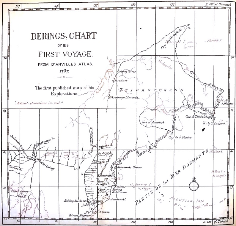
INSTRUMENTS AND METHODS.
In considering the work done by the expedition it is very necessary to bear in mind the character of the instrumental outfit, if any, which they might have possessed, and the state of the science of navigation at the time.
When Bering and his two cartographers left St. Petersburg in February, 1725, the astronomical instrument in use by navigators was the Davis quadrant or "backstaff," in which the sun's altitude was measured by sighting without a telescope or tube on the shadow cast by the sun from one projection of the instrument upon another, the observer's back of course, being turned to the luminary. The only alternative to this was the still older astrolabe with which the observer had to look along the two lines of his angle at the same time, and which also depended upon sights or spurs attached to a frame. The reflecting quadrant of Hadley was not invented until 1731 and telescopes were not used on the instruments of navigation until somewhat later. There were no chronometers or reliable watches or clocks for use in dividing intervals of time. Even after the Hadley quadrant came into use, time was noted by a pendulum vibrating seconds, which could not be used on ship-board.
A futile attempt had been made by means of tables of variation of the compass to determine the longitude by comparison with observed variation in the field. Results by this method approached the truth accidentally, if at all. Lunar observations were the only means of getting an approximation to the longitude except the occultations of Jupiter's satellites, both methods being impracticable on board ship, with the instruments then employed.
In 1731 the astronomer Halley proved2 that at that date it was still impossible to find the longitude correctly by the moon, the lunar tables being so inaccurate that an error of several hundred miles was quite possible and an accurate determination would depend upon the respective errors of instrument, observation and the lunar tables happening to balance one another. Halley ventured to express the hope that the tables may be so amended that an error may scarce ever exceed three minutes, which would correspond to a degree and a half of longitude, amounting at the equator to a distance of a little less than one hundred miles. Messerschmidt, who preceded Bering as an explorer of Eastern Siberia, was according to Middendorf (Sib. Reise, iv. 1, p. 56) thirty-two degrees out in his determination of the longitude, and the eastward extent of Asia in this region was underrated by that amount or thereabouts, on many maps.
2 Phil. Trans. 1731, No. 421.
One other means of approximating to the meridian remained, in the observation of eclipses. This from the comparative rarity of these occurrences in the case of the sun and moon, could with the imperfect instruments of those days be available but seldom. Owing to the difficulty of determining the exact time of the first and last contacts the longitudes computed by these observations were liable to quite as great inaccuracy as those computed from the lunar tables. Still an ordinary spyglass would enable an observer to note the time within a minute or two, and, if he was possessed of the local time, a simple comparison with the observed time of the eclipse in some locality where the longitude was known would give a fairly good determination, considering the instruments and methods of those days. Of the four eclipses of the moon occurring in 1728-9 two might have been observed without difficulty by Bering, one would have been invisible to him, and one might barely have been noted, but in all probability was not observed by him. In none of the published reports of the expedition is any mention made by Bering or his officers of the occurrence or observation of an eclipse, which seems very singular if by such an observation he was enabled to correct an error of 30° in the longitude of northeastern Siberia. However, Middendorf states (Sib. Reise, iv. 1, p. 56) that "Bering and his lieutenant in the years 1728 and 1729 observed in Kamchatka3 two eclipses of the moon," by which they corrected the longitude. He gives no authority for this statement.
3 It is possible that an eclipse observed at Ilimsk in Middle Siberia by Chirikoff is thus erroneously referred to.
Euler, who had access to the archives of the Admiralty College, while engaged on a Geography of Russia, mentions (Philos. Trans., No. 482, p. 421) that he was informed that Bering observed an eclipse "at Kamchatka." This letter of Euler's is copied by Campbell in Harris' Voyages (vol. II, Book III, p. 1024) and the expression "at Kamchatka" has led to the statement that these observations were made at the fort or village of Lower Kamchatka. This is an error since Bering gives no longitude for the fort in his table of geographical positions. It must be remembered that the name Kamchatka at that period was applied not merely to the peninsula as at present, but also to the whole region of northeastern Siberia, the governor of Kamchatka being located at Okhotsk. So to come within the probable meaning of the phrases used by Middendorf and Euler it is only necessary to suppose that the observations were made somewhere in that region. Lauridsen (Danish edition, note 34, p. 186) refers to a paper of Struve (Bull. phys.-math. Acad. St. Petersb., I, 1842, p. 290) containing a table of geographical positions in Russia, in connection with these alleged observations of Bering. An examination of Struve's paper does not bear out the implication of Lauridsen's reference, as Struve not only makes no mention whatever of Bering's observations there but specifically states that the first observations of precision made in this part of Siberia were those of Krassilnikoff who accompanied Bering's second expedition in 1741. It would seem extraordinary that a determination so important for geography as that of Bering and his companion should be unknown to so distinguished an astronomer as Struve who must have had access to all the archives of the early explorations by Russia. But it may be perhaps accounted for by the facts that Bering's observations were necessarily of a very rough and primitive character—as it is certain he had no instruments of precision; and that, for that reason, they were not received with entire confidence; so that Struve may have considered them insufficiently exact to be included with those of Krassilnikoff and others made with more modern appliances.
From the note in regard to the eclipses which is kindly contributed by Mr. Marcus Baker and from the other circumstances, it is evident that if Bering and his party made the observations alluded to, the eclipses noted were the partial eclipse of Feb. 25 (local calendar), 1728, of which he might have observed the last contact, or the total eclipse of Feb. 14, 1729, of which he might have observed the first contact and the totality. At the time of the last eclipse he was at Lower Kamchatka post, and as, in the list of positions handed in with his Report in 1730, no longitude is entered for this locality, it would seem that choice is reduced to the first of the two mentioned; which occurred when Bering was either at Bolsheretsk or on his way from that place to Lower Kamchatka, which he reached about a month later. Campbell's table of positions is credited by him to the year 1728, but my own opinion is that it was really derived (with various errors, interpolations, etc.) from Bering's table of 1730.
The ordinary method of getting the longitude of a place, and that upon which Bering originally depended, as his itinerary table shows, was by a continuous record of the distances and directions traveled from a point of known longitude. This record would afford the data from which the distance on a mean parallel, by means of a traverse table, could be computed. Laborious, imperfect, and slow as it was, it was the only sure reliance of the traveler in those days. Whether Bering observed an eclipse or not, it is certain that his original dependence was upon his itinerary, that his report was based upon that and that this part of his work was done as well as the nature of the method would permit. His silence about the eclipse may be due to the fact that he depended not upon astronomical but upon pedometric observations, to which the eclipse may have afforded some corrections. At any rate the pedometric determination of the distance between Tobolsk and Okhotsk or the peninsula of Kamchatka was in itself a tremendous undertaking.
I find by a rough calculation from Bering's data that the longitude resulting from his itinerary from Tobolsk to Okhotsk is 77° 36' E. The distance in a straight line is about 2,390 miles, but by the route Bering traveled the distance is a little more than 3,746 miles. The longitude in Bering's List of Positions is 76° 07', which differs from the pedometric measurement by 1° 29' (or about 45 miles). On Bering's map, Okhotsk is located in longitude 74° 30' E. of Tobolsk, while the most modern observations for Okhotsk put it in 142° 40' E. of Greenwich or 75° 40' E. of Tobolsk. So that Bering's pedometric measurement was nearly 60 miles in excess; his revised table (as corrected by the eclipse?) 27 miles in excess; and his map about 30 miles in error in the opposite direction. These discrepancies show the inexactness of the methods then in vogue and also that the pedometric method was not very much worse than the others in its results. Although there are several typographic or other errors in his table of itinerary which render exact comparisons impossible, it may be said that the error of the pedometric method, including the passage by sea from Okhotsk to Kamchatka, averages about two degrees or sixty geographical miles. In the cases of Okhotsk and Bolsheretsk the error is one of excess; in the case of the cape at the mouth of the Kamchatka river and of the turning point of the expedition north of Bering Strait, the result is too small by about the same amount.
That his chart and his revised list of positions should differ as they do, is quite as likely the result of the careless way in which the minutiæ of such work were generally regarded at that day, as to any difference of date, or of intentional modification.
To conclude our review of the instrumental means and methods then in use, it may be said that the compasses in use at that day were comparatively roughly made and more or less inaccurate. The variation was determined in a given latitude by the azimuth of the Polestar or the sun at setting observed by means of sights attached to the rim of the compass, which was a method accurate enough for the general purposes of navigation. The distance run was measured on shipboard by the log which was in about the same form and perfection as at present, being a very ancient invention.
The survey of a general coast-line was made by compass bearings on prominent points, repeated from successive stations, the distances of the ship's course being determined by the log and the courses by compass, with corrections for current and the variation. The lines thus obtained were checked by latitude observations made with Davis' backstaff when the weather permitted.
Apart from any of the methods mentioned it seems to have been overlooked that Bering might have corrected the longitudes of the N.E. Siberian coast by the ordinary dead reckoning kept on board his vessel, provided he started by adopting the longitude for the southern part of Kamchatka peninsula which was in common use on many of the charts of his day. Though it is true that the maps of that part of Siberia north and northeast from the Okhotsk sea were many degrees in error in the longitude, this observation does not hold good in regard to the southern end of Kamchatka. The work of the Jesuit fathers in China had already determined fairly well the position of China and Korea, while rude outlines of the northern islands of Japan, Sakhalin, the Kuriles and the south end of Kamchatka, were added to these on maps of Asia. The outlines are often very incorrect but it is quite evident what is intended. In nearly all early maps of this region which I have been able to consult, as for instance those of N. de Witt, I have found the south end of Kamchatka in approximately correct longitude. For instance, in the Novissimae Ephemerides of Manfredio, published at Bonn the same year that Bering left St. Petersburg, and which might well have been sent to him before he sailed, we find two charts of the paths of solar eclipses (Plates ii and iii). On these charts the meridian of 180° from Ferro passes across what is unmistakably the south end of Kamchatka, though northeastern Siberia remains a blank. This would be a sufficient starting point and is quite as correct as Bering's determinations; in fact is within a few miles of the modern longitudes for the same part of the peninsula. Dead reckoning along the shores of the peninsula, corrected by latitude observations, would have done all that was necessary to correct the meridian without observing any lunar eclipse, provided the surveyor started with such an assumption as Manfredio's or De Witt's charts supply.
SOURCES OF INFORMATION.
The general History of China [etc.] Done from the French of P[ere]. Du Halde [by R. Brookes]. London, John Watts, 1736. 4 vols. 8° with maps and ills.
This is referred to in the following text by the letter B.
This is the first English translation from the original French edition of the "Description géographique et historique de l'empire de la Chine" by the father J. B. Du Halde, published at the Hague in the same year as the above translation. The text of the original French I have not been able to consult, though, so far as Bering's voyage is concerned, there does not seem to have been any material abridgment in the translation above cited, for an opportunity of consulting which I am indebted to the Librarian of Congress.
The maps and charts of the original French edition were separately printed in an atlas by themselves, for the use of those who might desire to do without the text, under the following title:
Nouvel Atlas de la Chine, de la Tartarie Chinoise, et du Thibet: contenant Les Chartes générales & particulieres de ces Pays, ainsi que la Carte du Royaume de Corée; (etc.): Rédigées par Mr D'Anville, Géographe ordinaire de sa Majesté très Chrétienne, Précedé d'une description de la Boucharie, Par un Officier Suedois que a fait quelque sejour dans ce Pays. A la Haye, chez Henri Scheurleer MDCCXXVII. Folio, 12 pp. 42 charts.
The chart of Bering forms sheet 42, and differs from the others in being on Mercator's projection which indicates that it was copied directly from an original as stated in the text, and not redrawn. It is 20¾ by 93/8 inches on the neat-lines and is entitled:
"Carte des Pays traversé par le Capne. Beerings depuis la ville de Tobolsk jusqu'a Kamtschatka."
Beneath the title is a table of four transliterated Russian terms for fort, post, village and convent, with their French equivalents. This and certain peculiarities in the transliteration of proper names make it certain that the original chart was in Russian and that the transliteration was done by some one not perfectly familiar with both languages. There are a few errors of the engraver in rendering single letters "c" appearing for "t" and "r" for "e" in a few places. The longitude is reckoned in degrees east from Tobolsk to which 67° degrees when added will give practically the meridian east from Greenwich. The transcriber of the map from the Russian appears to have been a Dane, G. Kondet.
That part of this chart east from 112° E. Gr. has been fairly reproduced by Lauridsen (Chart I) with the omission of some unimportant names and the addition of a signature (not the ordinary autograph) of Bering. This is reproduced with a different running headline to accompany Olson's translation.
The fourth volume of Brookes' translation (pp. 429-440) contains
"A succinct narrative of Captain Beerings's Travels into Siberia:"
with a reduction of the above-mentioned map, on which there is no trace of the island of St. Demetrius, even its name, which alone appears on the Du Halde map, is here omitted. Otherwise this version of the map does not differ from Du Halde's, more than one copy of a drawing usually differs from another. When Bering started on his expedition he was accompanied by two cartographers (Bergh, First Voy. of the Russ. pp. 2-5, fide Lauridsen) Luzhin and Potiloff, and to one or both of them under Bering's direction the construction of the map in question was probably due.
When Bering made his report it was accompanied by a list of positions for important places visited by the Expedition.
Dr. Campbell, while gathering material for his second edition of Harris' Voyages, procured a copy of this unpublished list of positions and prints it in his account of Bering's travels, with the comment that it was sent by Bering from Kamchatka, before his return to Russia, and to the Senate at St. Petersburg, to which Bering did not report. Whether due to the transcriber or the printer there are several very obvious errors in the list as printed by Campbell, and when it is compared with Bering's own list we see that there are also several interpolations.
But the positions adopted in the chart, said by Du Halde to have been brought to St. Petersburg by Bering on his return (a statement confirmed by the mention of a chart in the report itself), are not identical with the positions enumerated in the list. This leads to the suspicion that Bering's first chart was not published, and that the chart issued was due to a recomputation and revision of his data. This suspicion is made stronger by the statement of Lauridsen, who gives no authority, however, that Bering's chart was made in Moscow in 1731,4 though this may merely mean that some of the copies which were distributed to various personages were so prepared.
[4 Lauridsen, Am. ed., p. 57.]
These manuscript copies of the chart and report were sent to various foreign courts, as a matter of general interest, by the Russian authorities. The copy used by Du Halde was communicated to him by the King of Poland who had received it as a "Present worthy of his regard and curiosity" (Du Halde, iv, p. 439, Brookes' ed.). Other copies were sent to Sweden and probably to England and other countries. In the journal, "Ymer," of the Swedish Society for Anthropology and Geography (1884, p. 93) is a short notice by E. Dahlgren of three manuscript copies of Bering's chart of his first expedition, or rather of charts embodying its results. Two of these charts are in the Royal archives of Sweden and measures 58 x 135 cm. One of them is ornamented with ten colored drawings of natives of Siberia. The other is without these but does not seem to be a copy of the first as it has a number of soundings between St. Lawrence and the Diomede Islands which are not on the former, and some names which are peculiar to it. Both have many more names than are given on the chart published by Du Halde. Both of the manuscripts have a legend referring to the coast from the Kolyma eastward, on the north coast of Siberia, to the effect that it is put down from older charts and information, doubtless furnished by the archives at Yakutsk. The third copy is in the possession of Baron Robert Klinckofström, of Stafsund, Sweden.
Through the kind offices of Baron Nordenskiöld and the generosity of Baron Klinckofström, the last mentioned chart has been forwarded to the writer through the Smithsonian Institution for examination. It appears to be essentially the same as the second of the two charts referred to as comprised in the Royal Swedish Archives. The result of my examination of it leads me to the belief that there were two different charts sent out in manuscript by the Russian authorities. The first, which I regard as the earlier, and which is certainly more accurate, shows the island of St. Demetrius in its proper place in accordance with Bering's Report and list of positions. It formed the basis of Campbell's engraving which will be referred to later, and of the chart which appears in the various editions of Du Halde. It is possible that this represents the original chart prepared by Bering in Kamchatka during the winter of 1728-9. The second and probably later form of the chart is represented by the Klinckofström chart, upon which the name and island of St. Demetrius have vanished and a smaller island in the corresponding latitude is represented close to the Siberian coast and westward from the meridian passing through the eastern extreme of East Cape. This island is named the island of St. Diomede. If it is intended as a revised position for the island of St. Demetrius of the other chart and of Bering's Report, it is in conflict with the facts and with the position assigned to St. Demetrius in the report. No one who had sailed between St. Demetrius and East Cape could have sanctioned such a position for the island with honesty. If a different island is intended the question arises, Why is St. Demetrius omitted? This second chart is obviously the basis upon which in D'Anville's chart of Asia (1753) the configuration of the eastern extreme of Siberia is based, and I suspect that the chart of the Imperial Academy of Sciences at St. Petersburg and the reproduction of Jefferys, were also derived from it as far as this region is concerned.
It would be rash, in the absence of authentic information which only the Russian archives can supply, to hazard an opinion as to the origin of the important difference between these charts. I may return to this point later. Apart from this, it may be added that the northern coast of Siberia from East Cape west to Cape Shelagskoi is represented as mountainous throughout its extent. A legend states that it is laid down from older charts and information. This relieves Bering from the responsibility for the fictitious or at least grossly erroneous and exaggerated form and direction given to Cape Shelagskoi on his chart. The west coast of the Okhotsk sea and part of its northeastern shores not visited by Bering are stated to be laid down from "information." This map is not dated and the blank space in the title left for Bering's autograph has never been filled. No name of draughtsman or place or authority of issue are indicated upon it. It measures 51 by 201/8 inches between the neat-lines. It is in black and white, the mountains washed in, the only color being small green trees as a conventional sign for wooded country. A copy of the earlier chart fell into the hands of Dr. Campbell and was published by him in his edition of Harris' Voyages,5 together with a version of the report which is more or less mutilated and to which the editor to make his book more readable has added certain flowers of rhetoric which detract from its accuracy. Campbell's copy of the map is the most perfect yet published and the only one showing the island of St. Demetrius in its proper place.
[5 HARRIS, JOHN. Complete collection of Voyages and travels [etc.]. London, T. Woodward [and others] 1748. 2 v. folio, maps and plates, Vol. 2, pp. 1016-1041, is devoted to a discussion of Bering's discoveries, entitled: Book III, Section VIII. "A distinct account of part of the northeast frontier of the Russian Empire, commonly called the country of Kamschatka or Kamschatska including the voyages of Captain Behring for discovering toward the East [etc.], collected from the best authorities both printed and manuscript."]
In Du Halde's copy and those derived from it the eastern border of the chart has cut off the island, though in some of them, as in that of 1736, the name remains. The only fault to be noted in Campbell's edition of Bering's map is the omission by the engraver of the small bay named Preobrazhenia by Bering and which, though it is not named, appears on the other editions of the map. The title is as follows:
"An exact chart of all the countries through which Capt. Behring travelled, from Tobolski Capital of Siberia to the country of Kamtschatka."
The size of the map is 7 x 12¾ inches. It extends on the east to the meridian of 126° east from Tobolsk which enables the "Isle of St. Demetrius" (our present Big Diomede) to appear in its proper place. The editions previously reported have all stopped at the 124th meridian, thus cutting off the island, whose name sometimes appeared and sometimes did not.
It will be observed that Dr. Campbell in this paper was the means of introducing the erroneous and obnoxious Germanized spelling of Bering's name into English literature. This is a pretty good indication that he had no autographic documents from Bering himself, and that his manuscripts were obtained from German sources, or at least had been transcribed into the German language. In his thorough search of the literature of the subject and lengthy discussion of the results, Dr. Campbell undoubtedly gathered the fullest account of the first expedition which had up to that date been printed. In order to enliven his history of the proceedings, the good Doctor occasionally rises to flights of fancy, and the theories he held were long since proved erroneous.