THE LAST SECRETS (continued 2)
Reading edition
These sledging parties on the way to Cape Columbia were soon organized, and, in addition, hunting parties were sent out, and a supply of fresh meat for the winter was obtained. "Imagine us," Peary wrote, "in our winter home on the Roosevelt ... the ship held tight in her icy berth, a hundred and fifty yards from the shore, the ship and the surrounding world covered with snow, the wind creaking in the rigging, whistling and shrieking round the corners of the deck houses, the temperatures ranging from zero to sixty below, and the ice-pack in the channel outside groaning and complaining with the movement of the tides."
In these words Peary gives us an excellent picture of the explorers' winter home—a home upon which the sun never shone for many months, but which, in spite of the darkness, was a home of unceasing industry and preparation. And among the innumerable activities that took place, none was more important than the task of attending to the dogs. Early in November, Peary had become anxious about these all-important factors of his expedition. Over fifty of them were already dead, and a few days later only 160 dogs out of the 245 with which he had arrived were left. A change of diet from whale to walrus meat put an end to these appalling losses; but Peary's anxiety until he discovered a way to prevent them can be easily imagined. For without any adequate supply of dogs he knew all too well that neither he nor any one else would ever reach the Pole.
By the end of the autumn season snow igloos had been built on the track to Cape Columbia. We have the best authority—namely, Peary's—for saying that one of these snow-houses can be built by four good workmen in an hour. Into this shelter the traveller literally crawls, for the only means of entrance is a hole at the bottom of one side, and when the last man of the party has got in, this opening is closed up by a block of snow already cut for the purpose.
Except for one most alarming experience, when in a terrific gale the ice made a stupendous attempt against the invading ship, the winter was spent rather with anxiety about the future than with worry about the present. No wonder that Peary speculated over what awaited him when he started upon his great march. After leaving Cape Columbia, over 400 miles separated him from his goal, and these miles had to be travelled over the ice of the Polar sea. "There is no land," he writes, "between Cape Columbia and the North Pole, and no smooth and very little level ice." But even ice through which the traveller must sometimes pick-axe his way is not the most serious impediment to those who would reach the Pole. The great obstacles—the ever-present source of anxiety—are the "leads" which constantly appear. These "leads" are really patches of open water, varying in extent, which the winds and tides cause in the ice's movement. For no reason that is apparent, these dangerous obstacles suddenly block the explorer's advance, and little can be done save to wait for them to remove themselves. These "leads" were to be Peary's greatest impediment in his march, and were destined to be fatal to one valued member of his party.
The final attack on the Pole began on 15th February, 1909, when Bartlett, with a pioneer party, left the Roosevelt, and a week later Peary started on his way. At this time 7 members of the expedition, 19 Eskimos, 140 dogs, and 28 sledges, divided into various parties, were engaged in the great effort to reach the Pole. It was arranged that all of these parties should meet Peary at Cape Columbia on the last day of February; and on that day Bartlett and Borop started from the cape with advance parties. The duties of these advance parties were as onerous as they were important. For it was to Bartlett that Peary looked for a trail by which the main party could travel.
On the second day's march, after Peary had left Cape Columbia and the land behind him, he met with his first open "lead," and a slight delay occurred. But on the following day this "lead" was covered with young ice, and Peary determined to cross it. "If the reader," he wrote, "will imagine crossing a river on a succession of gigantic shingles, one, two, or three deep, and all afloat and moving, he will perhaps form an idea of the uncertain surface over which we crossed this 'lead.' Such a passage is distinctly trying, as any moment may lose a sledge and its team, or plunge a member of the party into the icy water." And later on, when Borop was crossing an open crack, his dogs fell into the water, and the loss both of the dogs and the sledge with its invaluable load of provisions was only prevented by Borop's exceptional quickness and strength.
The explorers had advanced nearly 50 miles from Cape Columbia, when they were held up by a big "lead," which refused most obstinately to cover itself with ice strong enough to bear the sledges. For a week this open water delayed the expedition, and Peary had good reason to wonder if his most careful preparation and organization were once more to miss the success that they deserved. On 11th March, however, the parties managed to cross the "lead," and on the march that followed they crossed the 84th parallel.
When the explorers started on this journey, Peary did not announce how far each one of his companions was to accompany him on the march, and presently Dr. Goodsell and MacMillan, with Eskimos, sledges, and dogs, turned back. Then the main expedition consisted of 16 men, 12 sledges, and 100 dogs. On 19th March, Peary revealed the programme he intended to follow to Bartlett, Marvin, Borop, and Henson. First of all Borop was to turn back; five marches farther on Marvin was to go; and after another five marches Bartlett was to leave the Polar party, which would then consist of 6 men, 40 dogs, and 5 sledges.
Unlike most programmes, this one of Peary's was faithfully carried out. Borop returned when 85° 23' was reached, and during the next days the explorers advanced so rapidly that they succeeded in passing both Nansen's and the Duke of the Abruzzi's record for farthest north. In turn, first Bartlett and then Marvin started upon the homeward track, and Peary was left with 4 Eskimos—Egingwah, Seegloo, Ootah, and Ooqueah—Henson, 5 sledges, and 40 dogs.
Of these Eskimos, Ooqueah was the only one who had not been in any previous expedition; but all the same he was the most romantic of the party, because he was intent upon winning the rewards that would enable him to marry the girl of his choice. Glimmering before his eyes Ooqueah saw a whale-boat, a rifle, and other prizes which Peary had promised to those who went with him to the farthest point. Not for a moment was there any doubt about Ooqueah's keenness, for he was spurred on by two of the greatest incentives that any young man can have—a desire to be wealthy, and a desire to marry.
Left alone with Henson and the Eskimos, Peary still had 133 nautical miles* to travel before he reached his goal. This distance he intended to cover in five marches, and, provided that the gales would leave him in peace and not open the "leads" of water, he had every hope of carrying out his intention.
Up to this stage in the march Peary had been whipper-in, but in the last stages he led the van. And during the concluding stages it must be admitted that fortune smiled upon the travellers. True, that in this almost breathless rush for the Pole "leads" were not entirely absent, but such as were encountered did not seriously delay the marches. As, however, Peary got nearer and nearer to the Pole, the fear that the prize might at the last moment be snatched away from him by an impassable "lead" was constantly with him.
On 5th April the party reached 89° 25' N., and were within 35 miles of the Pole. So near, indeed, were they, that Peary writes: "By some strange shift of feeling the fear of the "leads" had fallen from me completely. I now felt that success was certain...."
And his confidence was justified. On April 6, 1909, Peary, with his coloured assistant, Matthew Henson, and the four Eskimos, reached the Pole, and there the leader of this successful party wrote the following note;—
"90° N. Lat., North Pole, 6th April 1909.
"I have to-day hoisted the national ensign of the United States of America at this place, which my observations indicate to be the North Pole axis of the earth, and have formally taken possession of the entire region and adjacent, for and in the name of the President of the United States of America. I leave this record and United States flag in possession.
"ROBERT E. PEARY, "United States Navy."
The explorers spent thirty hours at the Pole, and then started upon the long journey back to the coast of Grant Land. By 23rd April, favoured by beautiful weather, the party had reached Cape Columbia; so favoured, indeed, had they been that Ootah remarked on their arrival that "the devil is asleep or having trouble with his wife, or we should never have come back so easily."
On that same day Peary wrote in his diary: "I have got the North Pole out of my system after twenty-three years of effort, hard work, disappointments, hardships, privations, more or less suffering, and some risks."
The joy of success, tremendous as it was, could not but be dimmed by the news that awaited Peary on his return to the ship. For Marvin had lost his life, on the return journey, in trying to cross some young and treacherous ice, and the loss of this gallant and able man illustrates all too sadly the "some risks" of which Peary wrote—risks which all explorers in greater or less measure have to run.
As a conclusion to this chapter of adventure and determined effort, the words of that prince of explorers, Fridtjof Nansen, seem peculiarly appropriate. "From first to last," he wrote, "the history of Polar exploration is a single mighty manifestation of the power of the Unknown over the mind of man."
IV THE MOUNTAINS OF THE MOON
THE MOUNTAINS OF THE MOON
(Map, p. 112.)
Twenty-four centuries ago a line of Æschylus—"Egypt nurtured by the snow"—embodied a geographical theory which descended from Heaven knows what early folk-wandering. Aristotle with his 'aryuroun oros, the Mountain of Silver from which the Nile flowed, continued the tradition in literature. Meantime Sabæan Arabs, trading along the east coast of Africa, and making expeditions to the interior, came back with stories of great inland seas and snow mountains near them. What they saw may have been only Kilimanjaro and Kenia, but the popular acceptance of their reports points to the earlier tale linking the snows with the Nile valley. Greek and Roman travellers spread the rumour, and presently it found its way, probably through Marinus of Tyre, into the pages of the geographer Ptolemy.
Ptolemy had no doubt about these snows. He called them the Mountains of the Moon, and definitely fixed them as the source of the river of Egypt. For centuries after him the question slumbered, and men were too busied with creeds and conquests to think much of that fount of the Nile which Alexander the Great saw in his dreams. When the exploration of Equatoria began in last century the story revived, and the discovery of Kenia and Kilimanjaro seemed to have settled the matter. It was true that these mountains were a long way from the Nile watershed, but then Ptolemy had never enjoyed much of a reputation for accuracy.
Still doubt remained in some minds, and explorers kept their eyes open for snow mountains which should actually feed the Nile, since, after all, so ancient a tradition had probably some ground of fact. Speke in 1861 thought he had discovered them in the chain of volcanoes between Lake Kivu and Lake Albert Edward, but these mountains held no snow. He received a hint, however, which might have led to success, for he heard from the Arabs of Unyamwezi of a strange mountain west of Lake Victoria, seldom visible, covered with white stuff, and so high and steep that no man could ascend it. In 1864 Sir Samuel Baker was within sight of Ruwenzori, and actually saw dim shapes looming through the haze, to which he gave the name of "Blue Mountains."
In 1875 Stanley encamped for several days upon the eastern slopes, but he did not realize the greatness of the heights above him. He thought they were something like Elgon, and he christened them Mount Edwin Arnold (a name happily not continued); but he had no thought of snow or glacier, and he disbelieved the native stories of white stuff on the top. In 1876 Gordon's emissary, Gessi, recorded a strange apparition, "like snow mountains in the sky," which his men saw, but he seems to have considered it a hallucination. Stranger still, Emin Pasha lived for ten years on Lake Albert and never once saw the range—a fact which may be partly explained by his bad eyesight. Ruwenzori keeps its secret well. The mists from the Semliki valley shroud its base, and only on the clearest days, and for a very little time, can the traveller get such a prospect as Mr. Grogan got on his famous walk from the Cape to Cairo—"a purple mass, peak piled upon peak, black-streaked with forest, scored with ravine, and ever mounting till her castellated crags shoot their gleaming tops far into the violet heavens."
The true discoverer was Stanley, who, in 1888, suddenly had a vision of the range from the south-west shore of Lake Albert. Every one remembers the famous passage:—
"While looking to the south-east and meditating upon the events of the last month, my eyes were directed by a boy to a mountain said to be covered with salt, and I saw a peculiar-shaped cloud of a most beautiful silver colour, which assumed the proportions and appearance of a vast mountain covered with snow. Following its form downward, I became struck with the deep blue-black colour of its base, and wondered if it portended another tornado; then as the sight descended to the gap between the eastern and western plateaus I became for the first time conscious that what I gazed upon was not the image or semblance of a vast mountain, but the solid substance of a real one, with its summit covered with snow.... It now dawned upon me that this must be Ruwenzori, which was said to be covered with a white metal or substance believed to be rock, as reported by Kavali's two slaves."
Stanley had neither the time nor the equipment for mountain expeditions, though to the end of his life Ruwenzori remained for him a centre of romance. It was his "dear wish," as he told the Royal Geographical Society shortly before his death, that some lover of Alpine climbing would take the range in hand and explore it from top to bottom. In 1889 one of his companions, Lieutenant Stairs, made an attempt from the north-west, and reached a height of nearly 11,000 feet. Two years later Dr. Stuhlmann, a member of Emin's expedition, made a bold journey up the Butagu valley on the west, discovered the wonderful mountain vegetation, and nearly reached the snow level. In 1895 came Mr. Scott Elliot, who was primarily a botanist, but who, in spite of bad malaria, managed to struggle as far as 13,000 feet.
Then followed troubles in Uganda, and it was not till 1900 that the work of exploration was resumed. To make the story clear, it is necessary to explain that the range runs practically north and south, and that about half-way it is cut into by two deep valleys—the Mobuku running to the east and the Butagu running to the Semliki on the west. Fort Portal at the northern end is the nearest station; and as from it the eastern side is the more accessible, it was natural that the Mobuku valley should be chosen as the best means of access. In 1900 Mr. Moore reached its head, and ascended the mountain called Kiyanja to the height of 14,900 feet. He had no sight of the range as a whole, but he believed this to be the highest peak, and put the summit at about 16,000 feet. In the same year Sir Harry Johnston followed this route. He ascended to the height of 14,828 feet on Kiyanja, and saw from the Mobuku valley a mountain to the north, which he named Duwoni. He came to the conclusion that the highest altitude of the range was not under 20,000 feet, and in this view he was followed by other travellers, like Mr. Wylde, Mr. Grogan, and Major Gibbons, none of whom, however, actually made ascents of any peak.
The first serious mountaineering expedition was made in 1905 by Mr. Douglas Freshfield and Mr. A. L. Mumm, who suffered from such appalling weather that they had to give up the attempt. Being experienced mountaineers, however, they reached some valuable conclusions. From the plains they had a clear view of the tops, and ascertained that the mountain called Kiyanja at the head of the Mobuku valley was certainly lower than a twin-peaked snow mountain beyond it to the west. They also placed the extreme height of the range at no more than 18,000 feet. Meanwhile Lieutenant Behrens, of the Anglo-German Boundary Commission, had made an elaborate triangulation, and gave to the twin tops of the highest peak altitudes of 16,625 feet and 16,549 feet—measurements, let it be noted, which were only a few hundred feet out. One other expedition, which occupied the close of the same year and the beginning of 1906, deserves mention. Mr. A. F. R. Wollaston, of a British Museum party, found an old ice-axe in a hut (probably left by Mr. Freshfield), and, with a few yards of rotten rope, set off with a companion to climb Kiyanja. He reached a height of 16,379 feet, and also climbed a peak to the north, which he believed wrongly to be Duwoni, and which now very properly bears his name. The whole performance was a brilliant adventure, and Mr. Wollaston has published the story of his travels in a delightful book.*
Such was the position when, in April, 1906, the Duke of the Abruzzi and his party left Italy to solve once and for all the riddle of the mountains. The Duke was perhaps the greatest of living mountaineers. As a rock-climber his fame has filled the Alps, and no name is more honoured at Courmayeur or the Montanvert. He had led Polar expeditions, and had made the first ascent of the Alaskan Mount St. Elias. His experience, therefore, had made him not only a climber but an organizer of mountain travel. It was to this latter accomplishment that he owed his success, for Ruwenzori was not so much a climber's as a traveller's problem. The actual mountaineering is not hard, but to travel the long miles from Entebbe to the range, to cut a path through the dense jungles of the valleys, and to carry supplies and scientific apparatus to the high glacier camps, required an organizing talent of the first order.
The Duke left no contingency unforeseen. He took with him four celebrated Courmayeur guides, and a staff of distinguished scientists, as well as Cav. Vittorio Sella, the greatest of living mountain photographers. So large was the expedition that two hundred and fifty native porters were required to carry stores from Entebbe to Fort Portal. It was not a bold personal adventure, like Mr. Wollaston's, but a carefully planned, scientific assault upon the mystery of Ruwenzori. The Duke did not only seek to ascend the highest peak, but to climb every summit, and map accurately every mountain, valley, and glacier. The story of the work has been officially written,* not indeed by the leader himself, who had no time to spare, but by his friend and former companion, Sir Filippo de Filippi. It is an admirable account, clear and yet picturesque, and it is illustrated by photographs and panoramas which have not often been equalled in mountaineering narratives.
The charm of the book is its strangeness. It tells of a kind of mountaineering to which the world can show no parallel. When Lhasa had been visited, Ruwenzori remained, with the gorges of the Brahmaputra, one of the few great geographical mysteries unveiled. Happily the unveiling has not killed the romance, for the truth is stranger than any forecast. If the Mountains of the Moon are lower than we had believed, they are far more wonderful. Here you have a range almost on the Equator, rising not from an upland, like Kilimanjaro, but from the "Albertine Depression," which is 600 or 700 feet below the average level of Uganda; a range of which the highest peaks are 1,000 feet higher than Mont Blanc, which is draped most days of the year in mist, and accessible from the plains only by deep-cut glens choked with strange trees and flowers. The altitude would in any case give every stage of climate from torrid to arctic, but the position on the Line adds something exotic even to familiar mountain sights, draping a glacier moraine with a tangle of monstrous growths, and swelling the homely Alpine flora into portents. The freakish spirit in Nature has been let loose, and she has set snowfields and rock arêtes in the heart of a giant hothouse.
The Peaks and Valleys of Ruwenzori. The Route to Ruwenzori.
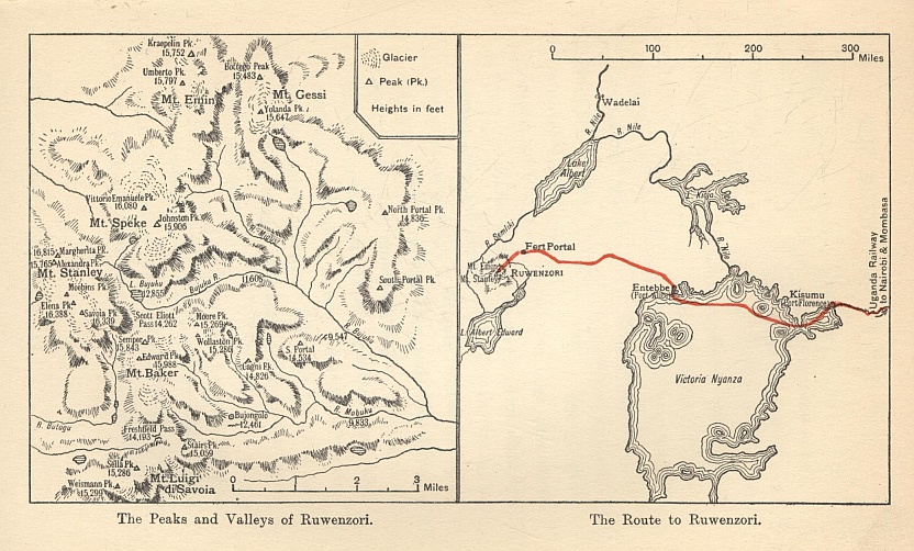
The Duke of the Abruzzi was faced at the start with a deplorable absence of information. Even the season when the weather was most favourable was disputed. Mr. Freshfield, following Sir Harry Johnston's advice, tried November, and found a perpetual shower-bath. Warned by this experience, the Duke selected June and July for the attempt, and was fortunate enough to get sufficient clear days to complete his task, though he was repeatedly driven into camp by violent rain. Another matter in doubt was the best means of approach to the highest snows. The obvious route was the Mobuku valley, but by this time it was pretty clear that Kiyanja, the peak at its head, was not the highest, and it was possible that there might be no way out of the valley to the higher western summits. Still, it had been the old way of travellers, and since the alternative was the Butagu valley right on the other side of the range, the Duke chose to follow the steps of his predecessors.
Just before Butiti he got his first sight of the snow, and made out that a double peak, which was certainly not Johnston's Duwoni, was clearly the loftiest. Duwoni came into view again in the lower Mobuku valley, and the sight, combined with the known locality of Kiyanja, enabled the expedition to take its bearings. Duwoni was seen through the opening of a large tributary valley, the Bujuku, which entered the Mobuku on the north side between the Portal Peaks. Now it had been clear from the lowlands that the highest snows were to the south of Duwoni, and must consequently lie between that peak and the Mobuku valley. The conclusion was that the Bujuku must lead to the foot of the highest summits, while the Mobuku could not. The discovery was the key of the whole geography of the range. But the Duke did not at once act upon it. He wisely decided to explore Kiyanja first; so, thinning out his caravan and leaving his heavier stores at the last native village, he with his party pushed up the Mobuku torrent.
The Mobuku valley falls in stages from the glacier, and at the foot of each stage is a cliff face and a waterfall. The soil everywhere oozes moisture, and where an outcrop of rock or a mat of dead boughs does not give firmer going, it is knee-deep in black mud. The first stage is forest land—great conifers with masses of ferns and tree-ferns below, and above a tangle of creepers and flaming orchids. At the second terrace you come to the fringe of Alpine life. Here is the heath forest, of which let the narrative tell:—
"Trunks and boughs are entirely smothered in a thick layer of mosses which hang like waving beards from every spray, cushion and englobe every knot, curl and swell around each twig, deform every outline and obliterate every feature, till the trees are a mere mass of grotesque contortions, monstrous tumefactions of the discoloured leprous growth. No leaf is to be seen save on the very topmost twigs, yet the forest is dark owing to the dense network of trunks and branches. The soil disappears altogether under innumerable dead trunks, heaped one upon another in intricate piles, covered with mosses, viscous and slippery when exposed to the air; black, naked, and yet neither mildewed nor rotten where they have lain for years and years in deep holes. No forest can be grimmer and stranger than this. The vegetation seems primeval, of some period when forms were uncertain and provisory."
But the third terrace is stranger still. There one is out of the forest and in an Alpine meadow between sheer cliffs, with far at the head the gorge of Bujongolo and the tongue of the glacier above it. But what an Alpine meadow!—
"The ground was carpeted with a deep layer of lycopodium and springy moss, and thickly dotted with big clumps of the papery flowers, pink, yellow, and silver white, of the helichrysum or everlasting, above which rose the tall columnar stalks of the lobelia, like funeral torches, beside huge branching groups of the monster senecio. The impression produced was beyond words to describe; the spectacle was too weird, too improbable, too unlike all familiar images, and upon the whole brooded the same grave deathly silence."
It is a commonplace to say that in savage Africa man is surrounded by a fauna still primeval; but in these mountains the flora, too, is of an earlier world—that strange world which is embalmed in our coal seams. Under the veil of mist, among cliffs which lose themselves in the clouds, the traveller walks in an unearthly landscape, with the gaunt candelabra of the senecios, the flambeaus of the lobelias, and the uncanny blooms of the helichryse like decorations at some ghostly feast. The word "helichryse" calls up ridiculous Theocritean associations, as if the sunburnt little "creeping-gold" of Sicily were any kin to these African marvels! Our elders were wise when they named the range the Mountains of the Moon, for such things might well belong to some lunar gorge of Mr. Wells's imagination. Beyond Kiyanja the Duke found a little lake where a fire had raged and the senecios were charred and withered. It was a veritable Valley of Dry Bones.
Ruwenzori from the Hill near Kaibo. (By permission of Messrs. Arch. Constable & Co., Ltd.)
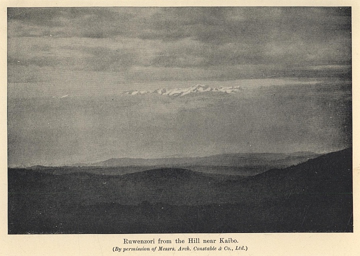
Bujongolo offered the expedition a stone-heap overhung by a cliff, and there the permanent camp was fixed. Among mildews and lichens and pallid mist and an everlasting drip of rain five weeks were passed with this unpromising spot as their base. The first business was to ascend Kiyanja. This gave little trouble, for the ridge was soon gained, and an easy arête to the south led to the chief point. The height proved to be 15,988 feet, and the view from the summit settled the geography of the range and confirmed the Duke's theories. For it was now clear that the ridge at the head of the Mobuku was no part of the watershed of the chain, and that the Duwoni of Johnston was to the north, not of the Mobuku, but of the Bujuku. The highest summits stood over to the west, rising from the col at the head of the Bujuku valley. The Duke saw that they might also be reached by making a detour to the south of Kiyanja, and ascending a glen which is one of the high affluents of the Butagu, the great valley on the west side of the system.
It may be convenient here to explain the main features of the range, giving them the new names which the expedition invented, and which are now adopted by geographers. Kiyanja became Mount Baker, and its highest point is called Edward Peak after the then King of England. Due south, across the Freshfield Pass, stands Mount Luigi di Savoia, a name given by the Royal Geographical Society and not by the Duke, who wished to christen it after Joseph Thomson the traveller. Due north from Mount Baker, and separated from it by the upper Bujuku valley, is Mount Speke (the Duwoni of Johnston), with its main summit called Vittorio Emanuele. West of the gap between Baker and Speke stands the highest summit of all, Mount Stanley, with its twin peaks Margherita and Alexandra. North of Mount Speke is Mount Emin, and east of the latter is Mount Gessi. Five of the great massifs cluster around the Bujuku valley, while the sixth, Mount Luigi di Savoia, stands by itself at the south end of the chain.
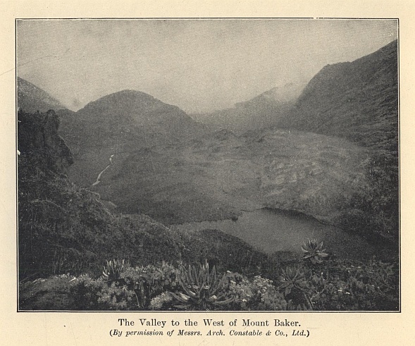
The assault on Mount Stanley was delayed for some days by abominable weather. At last came a clear season, and the Duke with his guides crossed Freshfield Pass and ascended the valley at the back of Mount Baker. There they spent an evening, which showed what Ruwenzori could be like when clouds are absent. They found a little lake, embosomed in flowers, under the cliffs, and looking to the west they saw the sun set in crimson and gold over the great spaces of the Congo Forest. Next day they reached the col which bears the name of Scott Elliot, and encamped on one of the Mount Stanley glaciers at the height of 14,817 feet. At 7.30 on the following morning they reached the top of the first peak, Alexandra, 16,749 feet high. A short descent and a difficult piece of step-cutting through snow cornices took them to the summit of Margherita (16,815 feet), the highest point of the range:—
"They emerged from the mist into splendid clear sunlight. At their feet lay a sea of fog. An impenetrable layer of light ashy-white cloud-drift, stretching as far as the eye could reach, was drifting rapidly north-westward. From the immense moving surface emerged two fixed points, two pure white peaks sparkling in the sun with their myriad snow crystals. These were the two extreme summits of the highest peaks. The Duke of the Abruzzi named these summits Margherita and Alexandra, 'in order that, under the auspices of these two royal ladies, the memory of the two nations may be handed down to posterity—of Italy, whose name was the first to resound on these snows in a shout of victory, and of England, which in its marvellous colonial expansion carries civilization to the slopes of these remote mountains.' It was a thrilling moment when the little tricolor flag, given by H.M. Queen Margherita of Savoy, unfurled to the wind and sun the embroidered letters of its inspiring motto, 'Ardisci e Spera.'"
The conquest of Mount Stanley was the culminating point of the expedition. After that, the topography being known, it only remained to ascend the four massifs of Speke, Emin, Gessi, and Luigi di Savoia. In addition, the Bujuku valley, with its tributary the Migusi, was thoroughly explored. The aim of the Duke being completeness, many of the peaks were ascended several times to verify the observations. There is an account of how from one peak in a sudden blink of fine weather the leader saw two portions of the expedition in different parts of the range moving about their allotted tasks. The result of this wise organization is that to-day the world knows every peak, glacier, and valley in Ruwenzori far more minutely than many habitable parts of the East African plateau. The expedition was not only a fine adventure, but a wonderful piece of solid and enduring scientific work. No Englishman will grudge that the honours of the pioneer fell to so brilliant a climber and so unwearied a traveller as the Duke of the Abruzzi. The Italian name has always stood high in mountaineering annals, and the Duke has long ago earned his place in that inner circle of fame which includes Mummery and Guido Rey, Moore and Zsigmondy.
The Valley to the West of Mount Baker. (By permission of Messrs. Arch. Constable & Co., Ltd.)
The riddle of equatorial snow has been solved, and there is nothing very startling in the answer. The upper part of the mountains has no marvels to show equal to the giant groundsels and lobelias and the forests of heath on the lower slopes. The glaciers are all small, without tributaries, as in Norway; and there are no real basins, but merely "a sort of glacier caps from which ice digitations flow down at divers points." All the same, the glacier formation is more respectable than Mr. Freshfield thought, for he saw only the small ice-stream at the head of the Mobuku, and was not aware of the much greater one from Mount Stanley which descends to the upper Bujuku valley. The limit of perpetual snow is about 14,600 feet. Mr. Freshfield was so struck by the small size of the Mobuku torrent where it issues from the glacier, and by its clearness, that he thought it must come from some underground spring rather than from a real melting of the ice. He maintained that tropical glaciers were consumed mainly by evaporation and only in a small degree by melting. The Duke has, however, made it clear that the glaciers of Ruwenzori are subject to the same conditions as those of the Alps, and that their streams are true glacier torrents. The limpidity of the water he ascribes to their almost complete immobility, which means that there is no grinding of the detritus in their beds.
On the whole, the range offers no great scope for the energies of the mountaineer. The ice and snow work is easy, and even the huge cornices, such as are found on Margherita, are fairly safe for the climber, owing to the way in which they are propped by a forest of ice stalactites caused by the rapid melting of the snow. On the other hand, there is abundance of rock climbing of every degree of difficulty, for the mountains below the snow-line fall very sheer to the valleys. Luigi di Savoia, Emin, and Gessi are virtually rock peaks; an isolated summit, Mount Cagni, is wholly rock; and there are fine rock faces on Mount Baker and the Edward and Savoia Peaks of Mount Stanley. I doubt, however, if Ruwenzori will ever be a centre for the rock gymnast. The weather would damp the ardour of the most earnest habitué of Chamonix or San Martino. A few hours of sunshine once a week are not enough in which to plan out routes up cliffs whose scale far exceeds the measure of the Alps. The Grepon or the Dru would have long remained virgin if their crags had been for ever slimy with moisture and draped in mist, and the climber had to descend to no comfortable Montanvert, but to a clammy tent among swamps and mildews.
And yet those peaks remain almost the strangest of the world's wonders, and their ascent will always be one of the finest of human adventures. They are Mountains of the Moon rather than of this common earth. The first discoverers brought back tales which were scarcely credible—ice-peaks of Himalayan magnitude, soaring out of flame-coloured tropic jungles. For long mountaineers were consumed with curiosity as to what mysteries lay behind that veil of mist. For all they knew, equatorial snow might be difficult beyond the skill of man, and Ruwenzori the eternal and unapproachable goal of the adventurer's ambition. The truth is prosaic beside these imaginings. Any man who can afford the time and the money, who selects the right time of year, and is sound in wind and limb, can stand on the dome of Margherita.
But the experience will still be unique, for these mountains have no fellows on the globe. There is a certain kinship between the tale of the first ascent of Mount McKinley in Alaska,* and that of the Duke of the Abruzzi. That gaunt icy peak is as unlike the ordinary snow mountain as Ruwenzori. The climb began from the glacier at a height of 1,000 feet, and 19,000 feet of snow and ice had to be surmounted. The Alaskan giant and the Mountains of the Moon stand at the opposite poles of climate, but both are alike in being outside the brotherhood of mountains. They are extravagances of Nature, moulded without regard to human needs. For mountains, when all has been said, belong to the habitable world. They are barriers between the settlements of man, and from their isolation the climber looks to the vineyards and cornlands and cities of the plains. An ice-peak near the Pole and a range veiled in the steaming mists of the Line are solitudes more retired and sanctuaries more inviolate. The common mountain-top lifts a man above the tumult of the lowlands, but these seem to carry him beyond the tumult of the world.
V THE SOUTH POLE
THE SOUTH POLE
(Map, p. 144.)
I
The imaginations of bold men were captured by the idea of Arctic exploration for centuries before the Antarctic was even thought of as a field for discovery. The Arctic regions have a history dating back to the days of King Alfred; the Antarctic can make no such boast as this, and it is true to say that attention was first drawn to the Far South by the map-makers.
Much praise is due to the early map-makers; but as regards the Far South it must be admitted that they indulged in considerable guesswork. Ortelius, for instance, in his map of the world which was published in Antwerp in 1570, had the temerity to draw the coast of "Terra Australia nondum cognita" round the world as far north, in two places, as the Tropic of Capricorn.
Hakluyt did, in 1599, omit the Southern continent from his celebrated map of the world, an abstinence on his part that deserves to be mentioned. But fictions, in spite of Hakluyt, continued to appear in later maps; and if they did nothing else, they were at least useful in directing the thoughts of navigators towards the Antarctic.
Accident rather than design was, however, responsible for the first discoveries in the South. In 1520 Magellan found the strait which is known by his name, and during the sixteenth century what discoveries were made in the direction of the South were due to contrary winds. Owing to gales, Sir Francis Drake, in 1578, reached in latitude 56° S. "the uttermost part of the land towards the South Pole," and so, sadly against his will, made discoveries. And it was owing to what has happily been called "a discovery-causing gale" that some Dutch ships, which had set out in 1598 for the exciting but scarcely laudable purpose of plundering the coasts of Chile and Peru, were scattered in all directions. One of these ships, a mere baby of 18 tons, was driven to 64° S., and there her captain, Dirk Gerritsz, sighted "high land with mountains covered with snow, like the land of Norway."
If proof of the universal ignorance of the South at the beginning of the seventeenth century is needed, we have the expedition of Pedro Fernandez de Quiros. Quiros was commissioned by the King of Spain, Philip III., to undertake a voyage for the purpose of annexing the South Polar continent; and after this annexation had been completed, he was commanded to convert the inhabitants to the true faith. It was an ambitious programme, and it was far indeed from being carried out. In fact, the result of the expedition was almost comical. Quiros discovered the largest island of the New Hebrides, and in the belief that it was part of the Southern continent, he not only annexed it, but also the South Pole itself, to the Crown of Spain! This expedition must be considered the first Antarctic expedition, but there is no denying that its results were more ludicrous than encouraging.
Little progress was made during the seventeenth century in adding to the world's knowledge of the South, but in one way and another the map-makers received severe buffets. Towards the end of that century and the beginning of the next, some ships reached 62° S. and 63° S., and encountering great icebergs, gained knowledge that tended to disperse the idea of a huge continent, from which men could reap wealth and live in comfort while reaping it. In spite, however, of this waning belief in a fertile and populous Southern continent, several voyages were undertaken to look for it; but it is to be noted that the men who made these adventurous journeys were not in the least interested in exploration for exploration's sake. The reason why they made these expeditions was mainly because they hoped to enrich themselves. Not until the latter half of the eighteenth century was there any change in what may be called the spirit of exploration; and then, in 1764, the English Government issued instructions to Commodore Byron which clearly showed that the importance of discovery, for discovery's sake alone, was beginning to be realized.
Science had been making progress, and the desire really to know, and no longer to guess at, the extent and nature of the world, perceptibly increased. Scientists, engaged solely on scientific work, accompanied both the expeditions of Marion and Kerguelen, and when Captain James Cook sailed in 1772 from Deptford, on what was the first British Antarctic expedition, he was also accompanied by scientists.
The name of James Cook will always be given a place of honour among explorers, for, quite apart from the discoveries that he made, he set an example of courage in facing dangers and difficulties that can never be forgotten. He and all the earlier navigators, we must remember, had to undertake their voyages in ships that were totally unfit to encounter ice. And when this fact is realized, we are compelled to admire the pertinacity with which they carried out their work, and to recognize that the results of their efforts were, under the circumstances, magnificent.
It has been well said that James Cook defined the Antarctic region and that James Ross discovered it; and, indeed, it would be difficult to overestimate the importance either of Cook's voyages or of those subsequently undertaken by Ross.
January 17, 1773, was a red-letter day in the annals of exploration, for during its forenoon Cook crossed the Antarctic Circle for the first time. Icebergs and loose pack-ice were then surrounding him, but he pushed on until he sighted closely packed ice. In his opinion he might possibly have pushed his way through this ice, but in such a ship as the Resolution (462 tons) he did not consider himself justified in making so dangerous an experiment. The latitude that he reached was 71° 10' S., longitude 106° 54' W.
Cook's expedition returned to Portsmouth in July, 1775, and then the value of his voyage was recognized. He had made the circuit of the Southern ocean in a high latitude, and had for ever crushed the idea of a fertile and fruitful Southern continent. If land lay beyond the Antarctic Circle, Cook thought that it must consist of "countries condemned to everlasting rigidity by Nature, never to yield to the warmth of the sun, for whose wild and desolate aspect I find no words." Cook, in short, had revealed the limits of the habitable globe, and his accounts of what he had encountered in the Far South did not encourage men, who were anxious to find land in which fortunes could quickly be made, to think longingly of the Antarctic.
After Cook's return no serious attempt at geographical discoveries in the South was made until the Russian Government, in 1819, sent an expedition, under Captain Bellingshausen, to the Southern seas. Bellingshausen's ambition was to rival Cook's feat of making the circuit of the Southern ocean in high latitude, and he achieved it. He was also the first explorer definitely to discover land within the Antarctic Circle.
Two or three years later James Weddell, whose real business was sealing, reached a latitude of 74° 15' S., more than three degrees to the south of Cook's farthest point; and for nearly twenty years Weddell's record remained intact.
During the first half of the nineteenth century the Southern seas became the scene of extensive sealing industries, and however much we may regret the wholesale slaughter that took place, we have to confess that some of these sealers made important geographical discoveries. Both Captain John Biscoe and Captain John Balleny were engaged in the Antarctic sealing trade, but they were fortunate enough to be employed by the firm of Enderby. Charles Enderby instructed his captains not to neglect geographical discovery, and his instructions were faithfully carried out. To the enterprise of Enderby, and to the courage and perseverance of his captains, we owe the discovery of Graham Land, Enderby Land, Kempe Island, and Sabrina Land.
A French expedition under Captain D'Urville, and an American one under Captain Wilkes, followed in 1840. D'Urville, who encountered so many icebergs that he felt as if he was "in the narrow streets of a city of giants," sighted land in latitude 66° S., longitude 140° E., and named this coast Adélie Land. Wilkes also claimed to have discovered land; but of his claims one of our greatest explorers has written: "Had he been more circumspect in his reports of land, all would have agreed that his voyage was a fine performance."
Two or three years before D'Urville and Wilkes set out upon their voyages, Colonel Sabine, at a meeting of the British Association, read a paper on the subject of terrestrial magnetism, and the result was that Polar exploration received a great incentive. By this time the importance of terrestrial magnetism in regard to the navigation of ships was admitted, and the Government was petitioned to send a naval expedition for the purpose of increasing our knowledge of this science in the South. A favourable reply was received from Lord Melbourne, and in 1839 Sir James Ross was appointed to command an expedition whose object was rather magnetic research than geographical discovery. Two old bomb vessels, the Erebus (370 tons) and the Terror (340 tons), were selected by Ross, and when their bows had been strengthened he had at his disposal the first vessels that could be navigated among the Southern pack-ice. A detailed account of Ross's achievements cannot be given, but of them Captain Scott wrote: "The high mountain ranges and the coastline of Victoria Land were laid down with comparative accuracy from Cape North in latitude 71 to Wood Bay in latitude 74, and their extension was indicated less definitely to McMurdo Bay in latitude 77½.... Few things could have looked more hopeless than an attack upon that ice-bound region which lay within the Antarctic Circle; yet out of this desolate prospect Ross wrested an open sea, a vast mountain region, a smoking volcano (Erebus), and a hundred problems of interest to the geographer."*
The highest latitude reached by Ross was 78° 10' S., and he described the huge wall of ice which he sighted there and named the Great Barrier, as a "mighty and wonderful object, far beyond anything we could have thought of or conceived." This Barrier was in later years found to be 400 miles wide, and of even greater length.
Slowly, very slowly, the Far South was being compelled to reveal some of its secrets, but in spite of the interest and enthusiasm caused by Ross's discoveries, many years passed, after his return to England in 1843, before further steps were taken to make geographical discoveries in the Antarctic.
But during this period, in which geographical enterprise languished, scientific research was being carried on. A great desire to increase the knowledge of the science of oceanography had sprung up, and as a practical outcome of the labours of scientists and inventors, the Challenger expedition, excellently equipped for scientific research, set out under the command of Captain Nares in January 1873. This expedition was in itself most important, but it is not belittling it to say that part of its value in the history of Antarctic exploration lies in the fact that it stimulated interest in the Far South, and this interest gradually increased until the wish to solve the mysteries of the South Polar regions became dominant in the minds of many men in England and Germany. In 1885 the British Association appointed an Antarctic Committee, and some two years later this Committee reported in favour of further exploration.
Great difficulties, chiefly financial, had, however, to be faced by the supporters of this expedition, and a shrewd blow was received when the Board of Trade refused to recommend a grant of money because there were no trade returns from the Antarctic regions!—a reply that might produce a derisive smile from the most zealous of economists. For the moment the idea of Antarctic exploration had received a decided setback. But determined men were working to conquer the practical difficulties; and none more determined than Sir Clements Markham, who was elected President of the Royal Geographical Society in May 1893.
No sooner was it generally known that a real effort was being made in England to make further discoveries in Antarctica—as it was by this time called—than several other countries were stimulated at various dates to send out expeditions. Borchgrevink, a Norwegian, De Gerlache, a Belgian, Otto Nordenskiöld, a Swede, and Charcot, a Frenchman, led expeditions, all of which did valuable work in the South.
II
In November, 1893, a meeting of the Royal Geographical Society was held, and the duties of the projected British expedition were stated. The first duty was "to determine the nature and extent of the Antarctic continent;" the fifth was "to obtain as complete a series as possible of magnetic and meteorological observations." Such an expedition was intended both to encourage maritime enterprise and to add to the world's knowledge. From the outset the promoters had decided that their expedition should be under naval control, but the Government could not be persuaded to take charge of it. The Admiralty, however, assisted both with the loan of instruments and by granting leave to officers and men on full pay.
Innumerable obstacles continued to hamper the promoters on every side, but they were slowly removed, and at last the ship was launched at Dundee in March, 1901, and christened the Discovery.
Sir Clements Markham, fourteen years before, had, in his own mind, selected the fittest commander if an expedition to the South ever became practicable. The name of this commander was Robert Falcon Scott, and after much opposition had been overcome—opposition which Sir Clements described as "harder to force a way through than the most impenetrable of ice-packs"—Scott's appointment was confirmed. A great attack upon the Antarctic regions was about to be made, but it is worthy of record that in the instructions issued to Captain Scott no mention of the South Pole as an objective was made.
By July the labour of preparation for the expedition was almost finished, and on August 5, 1901, the Discovery was visited by King Edward VII. and Queen Alexandra, and then started on her adventurous voyage. We can easily understand Scott's anxiety to be up and away, for he had no Polar experience to help and guide him, and his desire to justify the confidence placed in him must have been intense.
In the Discovery, in addition to Scott himself, were several men whose names were destined to become famous in the history of Polar exploration. Ernest H. Shackleton was a second-lieutenant; Ernest A. Wilson was described as surgeon, artist, and vertebrate zoologist; Edgar Evans was a petty officer; Frank Wild and Thomas Crean were A.B.'s; William Lashley was a stoker. Surely the nucleus of a goodly company.
Lyttelton, New Zealand, had been chosen for the headquarters of the expedition in the South, and the Discovery arrived there on 30th November. She stayed for three weeks to re-fit and take in provisions, and then started upon the next stage of her eventful journey. The Antarctic Circle was crossed on 3rd January, and soon afterwards the pack was on all sides of the ship; but she behaved splendidly, and Scott was delighted with the way she forced herself through the ice.
Scott's original intention had been that the Discovery should not winter in the Antarctic, but that, having landed a party of men, she should return northward before the ice made such a journey impossible. A hut had been provided for this party, but in February a spot was found in McMurdo Sound in which it was thought that the ship would pass the winter in safety. Consequently Scott decided to use the Discovery as his headquarters, and to utilize the hut for other purposes.
The task of erecting the huts (in addition to the main hut there were two smaller ones for magnetic work) was difficult, but it was eventually accomplished, and the party began to settle down to spend the approaching winter. Before, however, the winter set in, Scott, knowing how ignorant he and his companions were of sledging, was anxious to gain as much experience as possible. And the result of the sledging expeditions that were made only showed how urgently this experience was needed. "Even at this time [early in March]," Scott wrote, "I was conscious how much there was to be learnt, and felt that we must buy our experience through many a discomfort; and on looking back I am only astonished that we bought that experience so cheaply, for clearly there were the elements of catastrophe as well as of discomfort in the disorganized condition in which our sledge-parties left the ship."*
When the Discovery was brought into McMurdo Sound there was good reason to suppose that she would soon be frozen in. But weeks passed before the sea became frozen, and until the ship was firmly fixed in the ice there was always a chance that she might be driven away by a gale and be unable to return. This uncertainty hampered operations for some time, and it was not until the last days of March, 1902, that the ship was satisfactorily frozen in.
The sun departed at the end of April, and during the long winter that followed the party of explorers had much to occupy them and to discuss. Scott had taken dogs with him for sledging purposes, but although he knew that they must increase his radius of action, he always detested the idea of using them because of the suffering that must necessarily be caused. But the question of using dogs was only one of the many problems in connection with sledging that was debated during that Antarctic winter.
In judging the journeys that followed in the spring, it is to be remembered that as far as the Antarctic regions are concerned they were pioneer efforts, and also that the conditions of Antarctic sledging differ considerably from those of the Arctic. In these journeys Scott and his companions were taught lessons that were afterwards of the greatest value to other explorers as well as to themselves—lessons that nothing except experience could teach.
The journey that Scott, with Wilson, Shackleton, and several dogs, began on 2nd November with the object of pushing as far south as possible, was accompanied at the outset by a supporting party; but this party turned back by the 15th, and Scott, Wilson, and Shackleton had immediate cause to know how strenuous a task they had before them. The dogs were already causing anxiety, and were quite unable to do the work expected from them. Relay work, which meant that each mile had to be travelled three times, became the order of the day, and in consequence the advance towards the South was greatly hindered. Soon afterwards the men themselves began to suffer from blistered noses, cracked lips, and painful eyes; but on the 21st Scott took a meridian altitude, and found the latitude to be 80° 1'.
In spite of all discomforts and anxieties, Scott was in a happy mood that night when he wrote: "All our charts of the Antarctic regions show a plain white circle beyond the eightieth parallel.... It has always been our ambition to get inside that white space, and now we are there the space can no longer be a blank; this compensates for a lot of trouble."
South Polar Regions.
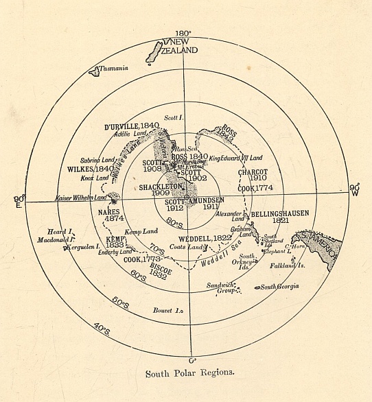
As the advance laboriously continued, the condition of the dogs, to Scott's poignant sorrow, went from bad to worse, and by 21st December the question of turning back had to be considered. At this time additional anxiety was caused by Shackleton, who was showing symptoms of scurvy; but Christmas Day was in sight, and as on that festival the travellers had decided to have a really satisfying meal, they resolved to push on farther.
Their meal on Christmas Day put new life into the party; but they realized all too acutely that their food supplies were so inadequate that, if they were to continue the advance they must be prepared to face the risk of famine. There were, however, strong incentives to urge them on their way. Each day took them farther and farther into regions hitherto untrodden by the feet of men. Who can blame them for taking the risks that were involved in their determination to continue the march?
But on 27th December, Wilson, whose industry in sketching and determination not to give in were beyond praise, was suffering so severely from snow-blindness that he had to march blindfold; and at last the decision to turn back had to be made. Observations taken at their last camp showed that they had reached between 82° 16' and 82° 17' S.—a finer record than Scott anticipated, after he had realized that the dogs were unable to fulfill the hopes placed in them.
The return march was a prolonged period of suspense. By January 9, 1903, only four out of the nineteen dogs which had started on the journey were alive, and on the 15th the last of them had to be killed. "I think," Scott wrote, "we could all have wept." Even more serious was the fact that at this time Shackleton became seriously ill.
A grim struggle followed, for although Shackleton showed unending courage he was suffering severely from scurvy, and Scott and Wilson, who were themselves attacked in a lesser degree by this disease, often had cause to wonder whether this return journey was not beyond their powers. It was with feelings of profound thankfulness that, at the beginning of February, Scott and his companions reached the ship. For ninety-three days they had been on the march, and during that time they had travelled 960 statute miles.
When the explorers reached their goal they found that the relief ship, the Morning, had arrived, and Shackleton returned in her; but the Discovery, after being so reluctant to freeze firmly into the ice, refused entirely to thaw out, and consequently Scott and most of his original party spent a second winter in the Antarctic. During this additional year Scott, with Edgar Evans and Lashley as his companions, made a wonderful western journey, in which adventures enough to last ordinary men for a lifetime were almost part of the daily routine.
Not until February, 1904, was the Discovery freed from the ice, and on 10th September she reached Spithead after an absence from England of over three years. In those years a crop of most useful information had been gathered, and many geographical discoveries had been made. Among the latter were King Edward Land, Ross Island, and the Victoria Mountains, and—most important of all—the great ice-cap on which the South Pole is situated.
Not for some years yet was the South Pole to reveal its secret, but Scott's first expedition may truthfully be said to have shown the way towards that revelation. In the years to come Amundsen frankly admitted how carefully he and his companions studied the accounts of Scott's and Shackleton's expeditions.
III
After Scott's return from his first visit to the Antarctic no further attempt was immediately made to visit the Far South. But that great explorer, Ernest Shackleton, had seen enough of the South to be gripped by the desire to solve more of its problems, and in the Geographical Journal of March, 1907, he stated the programme of a proposed expedition. In this programme Shackleton said: "I do not intend to sacrifice the scientific utility of the expedition to a mere record-breaking journey, but say frankly, all the same, that one of my great efforts will be to reach the southern geographical Pole."
The financial difficulties that seemed to be inseparable from Polar expeditions followed, but they were ultimately removed, and on July 30, 1907, the Nimrod sailed for New Zealand.
Bearing in mind the failure of the dogs in Scott's expedition, Shackleton decided to use Manchurian ponies as his principal means of traction. The utmost care was taken in preparing the equipment and in choosing the staff to accompany the expedition. Shackleton intended to land a shore party, and among this party were Frank Wild and Ernest Joyce (who had been with Scott), Douglas Mawson, Lieutenant J. B. Adams, Dr. E. Marshall, Raymond Priestley, and G. E. Marston.
Before leaving England, Shackleton decided, if possible, to establish his winter quarters on King Edward VII. Land in preference to Scott's old quarters at Hut Point in McMurdo Sound; but he was unable to carry out this plan, and ultimately he landed close to Cape Royds on the east coast of Ross Island. On February 22, 1908, his ship, the Nimrod, started upon her journey to New Zealand.
The winter quarters that had necessarily to be chosen were separated from Hut Point by some 20 miles of frozen ice, and Shackleton was greatly disappointed that he was prevented from landing on King Edward VII. Land, where he would not only have broken fresh ground, but would also have been considerably nearer to the Pole. In the light of subsequent events it is of interest to note that Shackleton, in his search for winter quarters off the Barrier, looked with eagerness upon a bay which he named "The Bay of Whales," but owing to the conditions of the ice he thought it necessary to leave this spot as quickly as possible. In another respect this expedition met with poor fortune—namely, in the loss of ponies. When the party settled down to spend the winter only four ponies were still alive, and it is no cause for wonder that they were watched with the closest attention. And as a Manchurian pony has been endowed with more than his fair share of original sin, he requires a very great deal of watching.
Before the winter set in, an attempt was made to reach the top of Mount Erebus, and this attempt met with a success that acted as a tonic both to those who took part in it and to those who had remained in winter quarters. As soon as mid-winter day had passed, Shackleton began to make arrangements for the sledging work that had to be done in the approaching spring. Depots had to be laid in the direction of the South Pole, which was over 880 statute miles distant from Cape Royds.
These preparations went on apace, and with a view to starting on the Southern march from the nearest possible point to the Pole, stores, etc., were transferred to Hut Point, and depots were also laid to help the travellers on their way. Adams, Marshall, and Wild were chosen to accompany Shackleton in this determined effort to reach the South Pole, and on 29th October they set out with the four ponies and the four sledges. By 3rd November they had left the sea-ice and were on the Barrier; but instead of finding a better surface they found it increasingly difficult. At the outset, however, the ponies did splendid work, though one of them, on 9th November, nearly disappeared into "a great fathomless chasm." At the time the travellers were in a nest of crevasses, and Adams's pony suddenly went down a crack. Fortunately, with help from Wild and Shackleton, the pony and the sledge were saved from falling into this abyss; but it was an alarming incident, for, as all the cooking gear and biscuits and a large portion of the oil were on this sledge, the loss of it would have been an irretrievable disaster to the Southern journey.
The 26th November was a day to be remembered by Shackleton and his companions, for at night they found that they had reached latitude 82° 18' S., and so had passed Scott's "farthest south." On 1st December, latitude 83° 16' S. was reached, but by this time three of the ponies had been killed, and only one was left. A few days later this last pony disappeared down a crevasse, and nearly took Wild and the sledge with him. Serious as the loss of this gallant pony was, there was great cause for thankfulness that Wild and the sledge had almost miraculously been saved. Had the sledge gone, only two sleeping bags would have been left for the four men, and the equipment would have been so short that the explorers could scarcely have got back to winter quarters.
Presently the travellers left the Barrier and attacked the great Beardmore Glacier which was between them and the plateau. On 9th December, 340 geographical miles lay between them and the Pole, and progress was painfully slow, for the surface consisted mainly of rotten ice through which their feet continually broke. A week later they had travelled over nearly 100 miles of crevassed ice, and had risen 6,000 feet; but the plateau which they so eagerly longed to reach still lay ahead of them. "Never," Shackleton wrote, "do I expect to meet anything more tantalizing than the plateau." Appalling surfaces, to walk on which Wild described as like walking over the glass roof of a station, continued after the plateau had been reached, and before Christmas arrived it was obvious, if the advance was to be continued, that absolute hunger, amounting almost to starvation, stared the explorers in the face.
On the evening of New Year's Day, 1909, the Pole was only 172½ miles distant, but the men's strength was nearly exhausted. The thermometer remained obstinately below zero, and on 6th January there were over 50 degrees of frost, with a blizzard and drift. A last dash onwards followed, and on 9th January Shackleton and his party reached 88° 23' S., and left the Union Jack flying on the plateau. The attempt to reach the Pole had failed; but it was a gallant attempt, and the homeward marches that followed show clearly enough that to have advanced farther was beyond the powers of the men. Indeed, the return journey was a terrible experience—a grim struggle against starvation; and to add to the misery of it, dysentery—owing, in Shackleton's opinion, to eating diseased pony's meat—attacked each member of the party. All that was possible had been done, and had not the wind been behind the explorers during one of their acutest periods of suffering, it is improbable that they would ever have reached their winter quarters.
While Shackleton was making his great march, a party, consisting of David, Mawson, and Mackay, had set out, with a view to determining the position of the south magnetic Pole. In this they were successful, the mean position of the magnetic Pole being marked down by Mawson as in latitude 72° 25' S., longitude 155° 16'. This was a great triumph for the explorers, and, needless to say, it was not gained without many perilous adventures and narrow escapes.
In March, 1909, the Nimrod returned safely to Lyttelton, New Zealand, where Shackleton and his men met with the warmest of welcomes. Once again the South Pole had resisted the attempt to locate it, but the time was drawing near for its mysteries to be disclosed.
IV
When, on September 13, 1909, Captain Scott published his plans for a British Antarctic expedition in the following year, Roald Amundsen was not thinking about the Far South. The Fram, it is true, was being prepared for a third voyage, but the Arctic was again to be her destination. Then, during the September of 1909 came the news that Peary had reached the North Pole. One of the great secrets of the world had been revealed; but another was still undiscovered, and Amundsen's thoughts were promptly turned from the Arctic to the Antarctic.
For various reasons Amundsen did not announce his change of plans, and when the Fram sailed in August, 1910, only a very few people knew where she was bound for. Not until the ship left Madeira did Amundsen announce his destination to the men who were accompanying him, and they received the news with joy.
In two or three respects Amundsen's expedition differed considerably from Scott's new expedition. Amundsen, for instance, relied on dogs for his motive power; Scott relied on ponies. Then, again, Amundsen decided to make his winter headquarters off the Bay of Whales, which was a degree farther south than McMurdo Sound, where Scott wintered. Scott was to take the Beardmore Glacier as his route to the South Pole; Amundsen's plan, when he set out for the Pole, was to leave Scott's route alone and push straight south from his starting-place. "Our starting-point lay 350 geographical miles," Amundsen wrote, "from Scott's winter quarters in McMurdo Sound, so there could be no question of encroaching upon his sphere of action." Lastly, it must be mentioned that the Norwegians were as at home on ski as they were on their feet, while most of Scott's men were at their best only moderate performers upon ski.
All went well with the Fram on her voyage to the South. She crossed the Antarctic Circle on January 2, 1911, and twelve days later she was in the Bay of Whales. In landing on the Great Barrier, Amundsen knew that he was taking a considerable amount of risk, for there was no certainty that it was not afloat where he landed on it from the Bay of Whales. In Amundsen's opinion, however, the Barrier there rests "upon a good solid foundation, probably in the form of small islands, skerries, or shoals."*
And indeed the Barrier treated him well. The landing was performed with supreme ease, and enough seals were found to relieve any possible anxiety as to the supply of fresh meat. Penguins, those delightful birds which provide both humour and food for visitors to Antarctica, were not plentiful, and those that were seen were chiefly of the Adélie species.
"Framheim," the hut in which the South Pole party were to live during the winter, was soon erected, and Amundsen found infinite satisfaction in the number of dogs which were safely landed. So far from losing dogs on the voyage, he had started with 97 and finished with 116, a most welcome addition.
The Fram, leaving eight men to winter on shore, was due to sail in the middle of February upon an oceanographical cruise, but before leaving she received some unexpected visitors. On 4th February, Captain Scott's ship, the Terra Nova, with the party which had vainly hoped to land on King Edward VII. Land, came into the Bay of Whales.
The news that Amundsen was safely established reached Scott on 22nd February, and he could not fail to be impressed by it. "One thing only," he wrote characteristically, "fixes itself definitely in my mind. The proper, as well as the wiser, course for us is to proceed exactly as though this had not happened; to go forward and do our best for the honour of the country without fear or panic. There is no doubt that Amundsen's plan is a very serious menace to ours. He has a shorter distance to the Pole by 60 miles. I never thought he could have got so many dogs safely to the ice. But above and beyond all, he can start his journey early in the season—an impossible condition with ponies."* Words that, in the light of future events, are more than ordinarily significant.
Before the winter set in Amundsen determined to deposit food, etc., on the way to the Pole, and on 10th February he set out on his first journey with three men, three sledges, and eighteen dogs.
This first trip upon the Barrier was full of exciting possibilities. Amundsen was without knowledge of the ground over which he had to travel, and he did not know whether the dogs would respond to the demands made upon them, or if his outfit would stand the severe test to which it was to be put. This was essentially a trial trip, and the travellers were naturally anxious that it should be successful. Eighty degrees South was reached, and in every respect save one Amundsen was satisfied with his journey. The only fly in his ointment was that time had been wasted in preparations before the party was ready to start in the mornings. But it was only a small fly, and Amundsen knew that with thought it could easily be removed. The dogs had responded so splendidly to the calls made upon them, that perhaps the most important question of all had been satisfactorily answered.
More depot-laying expeditions followed, and before the winter closed around the explorers, they had placed three tons of supplies at depots in latitudes 80°, 81°, and 82° S. Amundsen and his men could, therefore, settle down for their period of waiting with justifiable hopes that the great spring march to the Pole would end in triumph.
The winter was spent in paying attention to the minutest details of equipment, and the inhabitants of "Framheim" were kept gloriously busy and contented. But with the coming of spring Amundsen began to be impatient to be up and away on his great journey. Temperatures, however, remained very low—somewhere in the neighbourhood of -60° F.—and until they ceased "to grovel in the depths," no start could be made.
With the beginning of September the temperatures began to improve, and Amundsen was determined to start as soon as he possibly could, arguing that he could turn round and come back if he found that he had started too soon. So on 8th September he did set out, and soon discovered that the dogs could not endure the intense cold. On the 11th the temperature was -67.9° F.; on the following day it was -61.6° F., with a breeze dead against the travellers. On reaching the 80° S. depot, Amundsen deposited more stores, and then returned to "Framheim."
More than a month passed before the South Pole party was able to make another start, and it is of interest to note that, whereas Amundsen ultimately got off on 19th October, Scott was unable to start before 1st November.
The South Pole party which set out from "Framheim" consisted of Amundsen, Hanssen, Wisting, Hassel, and Bjaaland, and they were accompanied by fifty-two dogs drawing four sledges. As an illustration of the dangers that lay between the explorers and the Pole, it is enough to say that on the first day's journey a terrible disaster was only avoided by a few inches. In the thick weather they had steered too far to the east, and almost fell into what Amundsen describes as "a yawning black abyss, large enough to have swallowed us all, and a little more."
On the 21st Bjaaland's sledge sank down a crevasse, and had to be unloaded before it could be brought again to the surface. Wisting, with the Alpine rope fastened round him, went down and unloaded the sledge, and when he came up again and was asked if he was not glad to be out of such a position, he replied, "It was nice and warm down there."
It is true that such events are far from unusual in the lives of Polar explorers, but Wisting's answer is worth quoting, because it is typical of the cheerful spirit shown by Amundsen's companions during the whole of the journey. In temperament they were admirably suited for the task that they had undertaken.
With a view to landmarks on the return journey, Amundsen, rightly leaving nothing more to chance than he could help, decided to build snow-beacons. The first beacon was built in 80° 23' S., and altogether 150 beacons were erected, six feet in height.
Up to 82° S. the course had already been travelled by depot-laying parties, but when, on 6th November, they left 82° S. behind them, their journey was absolutely into the unknown. At this time they were marching about 23 miles daily, and at this rate they advanced a degree in three days.
On reaching 83° S., the explorers deposited provisions for five men and twelve dogs for four days, and depots were subsequently made at 84° S., and 85° S. It was from the latter depot that they decided to make what may, without exaggeration, be called their dash for the Pole. From their camp at 85° S., the distance to the Pole and back was 683 miles. After consideration Amundsen determined to take forward provisions, etc., for sixty days on the sledges, and depot the rest of the supplies and outfit.
A weary ascent to the plateau lay before the explorers, and they started upon it on 17th November. Three days later they had reached the plateau, but although they were happy enough in having accomplished a long and dangerous climb, their first camp on the plateau was not one of happy memory.
Grim work had to be done. Amundsen arrived on the plateau with forty-two dogs, but twenty-four of them had to be killed when the plateau was reached. It was a sacrifice that had to be made if the success of the expedition was to be considered; but no one can read Amundsen's account of it without recognizing how bitterly he and his companions regretted the necessity.
This camp, not without reason, was called "The Butcher's Shop," and as both the men and dogs required rest before setting out on the final stages of their march, it had been decided to remain there for two days. The eighteen remaining dogs were divided into three teams, with six dogs in each team, and one sledge was left behind.
But owing to the weather the explorers could not leave this hated "Butcher's Shop" until 25th November, and when they did set out again a blizzard was blowing. So tired, however, were they of waiting in such an inhospitable and gruesome spot, that all of them were eager to quit it—whatever the conditions of the weather might be.
Fog subsequently impeded the party, and again and again Amundsen blessed the assistance that they received from ski. "I am not," he wrote, "giving too much credit to our excellent ski when I say that they not only played a very important part, but possibly the most important of all, on our journey to the South Pole. Many a time we traversed stretches of surface so cleft and disturbed that it would have been an impossibility to get over them on foot."*
The 7th December was a great day for the expedition, because during it they passed Shackleton's "farthest south," 88° 23' S. They proceeded for another two miles, and then determined to make their last depot. So important to them was this depot that they not only marked it at right angles to their course, but also by snow beacons at every two miles to the south.
As the explorers approached the Pole, Amundsen, very naturally, was beset by nervousness. "Would he be there first?" was a question that kept on recurring in his mind. There was no cause to worry. Blessed by fine weather, he and his companions reached the South Pole on December 14, 1911, and the five of them together planted the pole from which the Norwegian flag flew. "Thus we plant thee, beloved flag, at the South Pole, and give to the plain on which it lies the name of King Haakon VII.'s Plateau."
On this day Scott was still struggling on his great march to the same destination, which he reached in the third week of January.
The calculations that Amundsen carried out at the South Pole gave its latitude as 89° 56' S.
Amundsen had won the race, and with his victory had revealed one of the great secrets of the world. His success had been gained by strenuous labour, great courage, and infinite care. And if Britons connect Scott's name inseparably with the South Pole, and honour it as that of one of their heroes, they do not for a moment grudge Amundsen the honour due to him as one of the greatest explorers of all time. For Amundsen was the first to discover the South Pole, and no one wishes, or is likely, to forget it.
The Norwegians reached the Pole with seventeen dogs, one of which had to be killed there, and they travelled back with two sledges, a team of eight dogs in each sledge. On his return journey Amundsen was fortunate enough to meet with favourable winds and weather, and the explorers arrived at "Framheim" on January 25, 1912, having travelled 1,860 miles in ninety-nine days. It was a glorious achievement, a great victory over conditions that are scarcely conceivable to any one unacquainted with the Antarctic or Arctic regions.
V
To pass from Amundsen's expedition to Scott's last expedition is to turn from one splendid exploit to another. Scott, as every one knows, was beaten in the actual race for the South Pole. But he and his friends reached their goal, and the tale of their struggle against misfortune after reaching it is one of the finest and most pathetic in the world.
When Scott's intentions to lead another Antarctic expedition were known, no less than eight thousand applicants volunteered to go with him, and among this enormous number were several men whose names will for ever find a place in the history of Polar exploration.
When the Terra Nova sailed from Lyttelton, New Zealand, for the Antarctic regions, on November 29, 1910, she carried both ponies and dogs. Three motor-sledges, one of which was lost in landing, were also taken, and Scott, with his intense dislike for the cruelty inseparably connected with the use of animals for motive power, hoped that these sledges would do much to save the ponies and dogs. Owing to engine trouble these hopes were not realized, but in connection with them Sir Clements Markham has written: "Captain Scott was quite on the right tack, and, with more experience, his idea of Polar motors will hereafter be made feasible, a consummation which was very dear to his heart."*
The Terra Nova was by no means as fortunate as the Discovery in making her way to the Antarctic. At the beginning of December she encountered a prolonged and terrific storm, and subsequently she had to fight her passage through some 370 miles of ice. Not until January 3, 1911, did she reach the Barrier, five miles east of Cape Crozier. Here Scott had hoped to make his winter quarters, but owing to the swell no landing could be made, and on the following day he decided to land at Cape Evans, 14 miles north of the Discovery's winter quarters. Strenuous work followed, and in a few days everything necessary had been landed from the ship, the house was soon built, and the explorers were ready to start laying depots in preparation for the march to the Pole.
On his first depot-laying journey Scott was accompanied by eleven men, eight ponies, and twenty-six dogs. He was more than a little doubtful about the dogs, but thought his ponies were bound to be a success. "They work," he wrote, "with such extraordinary steadiness.... The great drawback is the ease with which they sink into soft snow—they struggle pluckily, but it is trying to watch them."
This depot-laying party reached latitude 79° 29' S., and there left over a ton of stores; consequently the name of One Ton Camp was bestowed upon it. On the return journey disasters happened that seriously affected the success of the expedition, for six out of the eight ponies were lost. "Everything out of joint with the loss of our ponies, but mercifully with all the party alive and well," is Scott's comment on this grave misfortune. Ten ponies still remained.
During the winter Wilson, Bowers, and Cherry-Garrard started on June 27, 1911, upon their famous journey to Cape Crozier to visit the Emperor penguin rookery, and they did not return to Cape Evans until 1st August. During these weeks they had to fight against appallingly low temperatures. When, for instance, they started from Cape Evans, their three sleeping-bags weighed 52 lbs., but owing to the ice that had collected upon them these three bags weighed 118 lbs. when the travellers returned. Scott considered that no praise was too high for men who would face such weather during the Polar winter.
With the beginning of August preparations for the great march went on apace, but it was not until 1st November that a start could be made from Cape Evans. Night-marching was decided upon, and the order of marching was at first settled by the speed of the ponies, for some of them were slow, some fairly fast, and some were "fliers." The motors, with E. R. Evans, Day, Lashley, and Hooper with them, had already started, and the dogs, under the control of Meares and Demetri, were to follow behind the last detachment of men and ponies. Very soon, however, the motor-party were in trouble, and this party had to abandon their machines and push on as a man-hauling party.
By 15th November Scott reached One Ton Camp, and fears about the ponies began to take shape. At Camp 19 the explorers were within 150 miles of the Beardmore Glacier, but some of the ponies were beginning to fail, and at the next camp the first of them ("the gallant Jehu") had to be shot. From this camp it was arranged that Day and Hooper should turn back.
At Camp 22 the Middle Barrier depot was made in latitude 81° 35', and then for some days the march was impeded by extraordinarily foul weather. Scott's desire was to take the ponies as far as the entrance to the Beardmore Glacier; but although, on 29th November, at Camp 5, they were only 70 miles from what he calls his "pony-goal," some of the willing animals were very tired.
At Camp 29 six ponies were still left out of the ten which had started, but although the chances of getting through successfully to the glacier were good, the weather still remained as obstructive as possible.
On 5th December a terrific fall of snow added to the anxieties of the explorers, who found themselves within 12 miles of the glacier, but hopelessly held up by such a violent and unexpected storm. It was natural enough for Scott to be anxious, for on 7th December the food that he had hoped only to use after the glacier was reached had to be begun on. Two days later, however, by marching under terrible conditions, the entrance to the glacier was gained, and then at Camp 31, which was called Shambles Camp, the last of the ponies were killed.
On 9th December, Wilson wrote: "Nobby [Wilson's special pony] had all my biscuits last night and this morning, and by the time we camped I was just ravenously hungry. Thank God the horses are now all done with, and we begin the heavy work ourselves."
At Camp 32 the Lower Glacier depot was built, and soon afterwards Meares and Demetri, with the dogs, turned back for home. At this time the parties were made up of—
Sledge 1. Scott, Wilson, Gates, and P. O. Evans.
Sledge 2. E. Evans, Atkinson, Wright, and Lashley.
Sledge 3. Bowers, Cherry-Garrard, Crean, and Keohane.
But by 21st December, in latitude 85° S., Scott had to send back four of these men, and Atkinson, Wright, Cherry-Garrard, and Keohane returned. The Upper Glacier depot was made, and the returning men took back a letter from Scott in which he wrote: "So here we are practically on the summit, and up to date in the provision line. We ought to get through."
On New Year's Day, 1912, the party were within 170 miles of the Pole. Three Degree depot was made. Then in latitude 87° 32' S., Scott was compelled to send back E. B. Evans, Crean, and Lashley. When all of the men were so anxious to go on it was hard to have to part with any of them; but questions of food made it absolutely necessary that some of the party should return.
The ages of the five men who marched on to the Pole were: Scott, forty-three years old; Wilson, thirty-nine; P. O. Evans, thirty-seven; Gates, thirty-two; and Bowers, twenty-eight. Again and again Scott expressed his admiration of his four companions: Wilson, "never wavering from start to finish"; Evans, "a giant worker"; Bowers, "a marvel—he is thoroughly enjoying himself"; Gates, "goes hard all the time."
With such men Scott felt confident, in spite of terrible surfaces, of reaching the Pole. But as he approached it, fears that Amundsen had already arrived were constantly besetting him; and on 16th January, when within a few miles of the longed-for goal, there was no longer any doubt that the Norwegian party had won the race. Sledge and ski tracks and the traces of dogs were all too evident.
Faced by such a grievous blow, not one of Scott's party could sleep that night, but on the day following they marched on some 14 miles and reached the Pole. "The Pole," Scott wrote, "yes, but under very different circumstances from those expected."
It is impossible to conceive a greater blow, and when it is remembered that Scott and his four companions were already fatigued—if not completely exhausted—by their tremendous labours, it is easy to realize how heavily the disappointment hung on their minds. Nevertheless they had set out to reach the Pole, and they had reached it. All honour is due to them; and the fact that Amundsen had preceded them in no way diminished the glory of their achievement.
The altitude of the Pole, as estimated by Scott, is about 9,500 feet. A cairn was built, and the Union Jack hoisted. And then on Thursday, 18th January, they turned their backs upon their goal, and began the long march that separated them from Cape Evans. Anxiety about food began at once—not until Three Degree depot was reached could it be lessened; and very soon anxiety at Evans's condition was added to the danger of the scarcity of food.
On Wednesday, 31st January, the weary travellers reached the Three Degree depot, but by this time Evans had dislodged two finger-nails, and his general condition was very bad. Their next objective was the Upper Glacier depot, and on Monday night, 5th February, they were within from 25 to 30 miles of it; but so critical had the health of Evans become that Scott was desperately eager to get off the plateau. "Things," he wrote, "may mend for him [Evans] on the glacier, and his wounds get some respite under warmer conditions."
On the evening of 7th February they reached the Upper Glacier depot, and then, after turning aside to collect geological specimens (which proved to be most valuable), they met with terrible surfaces and weather. On 14th February, with 30 miles still to go before the Lower Glacier depot was reached, Scott's anxiety about the condition of the party was acute. Indeed, poor Evans had almost reached the limit of human endurance, and during the night of 17th February he became unconscious, and died quietly at 12.30 a.m.
It was a terrible experience for men, already supremely fatigued both in mind and body, to meet, and it was a sorrowful party which, on Sunday afternoon, arrived at Shambles Camp. There horse meat in plenty awaited them, and this gave them the renewal of strength that was sadly needed. For the moment the prospects of the explorers looked a little more hopeful, but from this point of their march they began to suffer from a lack of oil. When, at length, they succeeded in arriving at the Middle Barrier depot, on 2nd March, they found so little oil that it was scarcely enough, however economically used, to carry them on to the next depot, which was 71 miles distant. Another irretrievable disaster was the fact that Oates's feet were very badly frost-bitten. On 4th March, Scott wrote: "I don't know what I should do if Wilson and Bowers weren't so determinedly cheerful over things." And in all truth the position had become desperate. On the 7th, when still 16 miles short of Mount Hooper depot, Oates, though wonderfully brave, was in terrible pain. During the next day they arrived at Mount Hooper, but the shortage of oil was not relieved.
Over 70 miles separated the exhausted travellers from One Ton Camp, and they struggled onwards with death staring them ever nearer and nearer in the face. With no helping wind, and bad surfaces, they could not advance more than six miles a day, and on the night of the 11th, Scott reckoned up the situation in these words: "We have seven days' food, and should be about 55 miles from One Ton Camp to-night; 6x7=42, leaving us 13 miles short of our distance, even if things get no worse."
Unhappily, instead of any improvement in the situation, misfortunes became more and more plentiful. It was obvious that Oates was near the end, and on the morning of the 15th or 16th, when the blizzard was blowing, he walked out of the tent. "I am just going outside, and may be some time," were the last words he spoke to his companions in distress. "We knew," said Scott, who still continued to write his journal, "that poor Oates was walking to his death ... it was the act of a brave man and an English gentleman."
Oates sacrificed himself in the hope of helping the others, and no brave man ever performed a braver act. But his sacrifice was of no avail. Fortune had declared too strong a hand against the explorers for them to be able to resist it.