EARLY DEVELOPMENT OF THE NATIONAL MONUMENT
Reading edition
Under the general direction of the NPS, various relief agencies such as the Emergency Relief Administration (ERA), the Resettlement Administration, the Works Progress Administration (WPA), and the Civilian Conservation Corps (CCC) worked on development projects in the area. Only a few scattered reports are now available on the work of these agencies. About 150 persons were employed at the area in January 1937 on such projects as resurfacing, backsloping, ditching, and grading roads.[147] This included major reconstruction of the Sheep Mountain Canyon road, completed the same year.[148]
One project of interest completed June 30, 1940 by ERA labor, under the Public Roads Administration, was the obliteration of two tunnels along the Pinnacles-Cedar Pass road. They were constructed during the first half of the 1930’s (see Figure 19) when the road was built by the State of South Dakota; the road was completed in 1935. The tunnels proved to be impractical because of inadequate width and maintenance problems.[149]
In July 1940 the ERA project in the area was discontinued. Among the types of work accomplished since July 1, 1938, when the project was initiated, were the construction of five project headquarters buildings, prospecting for water on the national monument, the development of a well near the site of the old Pinnacles Checking Station, and ten road jobs which included road construction, widening, graveling, building culverts, and banksloping. The construction of parking overlooks, and the obliteration of buildings and clearing of 16 farmstead tracts, also took place during that time.[150]
During the 12 months between July 1939 and July 1940, the ERA project employed an average of 150 relief workers.[151]
Since the national monument is located a relatively short distance from Wind Cave National Park, the older area co-ordinated the business of Badlands during its early years. On August 11, 1939, Chief Ranger Howard B. Stricklin of Wind Cave became acting custodian of the newly designated area and was later placed in charge of the local ERA and CCC projects.[152] Although the ERA project was terminated in July 1940, the CCC work continued until June 1942.[153]
When Stricklin arrived to take charge, there were no living quarters of any kind in the area. He lived at the CCC camp at Quinn Table while his family remained at Wind Cave. Temporary offices were established in Wall pending a decision regarding the location of permanent headquarters.[154]
Considerable thought was given to the selection of a headquarters site. For a time the Pinnacles area was considered.[155] However, in late 1939 it was finally decided to locate the center of operations at Cedar Pass.[156] This decision was due, in part, to the offer by Mr. Ben H. Millard, owner of Cedar Pass Lodge,
to donate approximately 28 acres of strategically located land in the Cedar Pass area to the Service to be used as a headquarters area.[157]
44
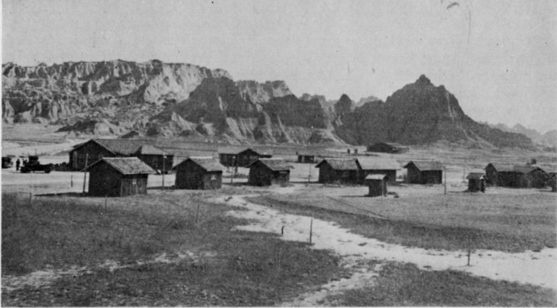
Figure 20 CEDAR PASS LODGE, early 1930’s
The lodge was begun in 1928 at about the same time the large dance pavillion building in the background was constructed. People from as distant as Rapid City came here to dance to the music of Lawrence Welk and other name bands. More cabins for the lodge were built from its lumber when the pavillion was removed in about 1934.[159]
The Department of the Interior accepted Millard’s donation in May 1941.[158]
The decision to develop the Cedar Pass area for headquarters greatly altered development plans. The CCC enrollees numbering 207 in February 1940 were encamped at Quinn Table some 35 miles west of Cedar Pass. Since much of the development was taking place at Cedar Pass, it was necessary to drive them between these two points each day.[160]
One of the great handicaps of Cedar Pass as a headquarters area was the lack of water. To develop a satisfactory supply, the NPS found it necessary to go to the White River, three miles south. One of the major projects undertaken soon after selecting the headquarters site was to dig a trench and lay pipe to the river. Since this stream is intermittent above ground, but has a dependable subsurface flow, water was collected in perforated pipes laid on hard clay and shale about eight feet below the river bed. The pipe brought water to a sump on the river bank where it was pumped to a 100,000-gallon storage tank above the headquarters area.[161] Work was begun on this reservoir in April 1940 and completed by the CCC in September 1941. At the same time the CCC also erected a checking station at Pinnacles which Stricklin and his family occupied from November 15, 1940, until about May 15, 1943.[162]
Handicapped by the location of the original CCC camp at Quinn Table, a new camp was authorized at Cedar Pass and work on it began in June 1941. Five months later the new camp was occupied.[164]
At that time the only visitor-contact point in the Cedar Pass area was at Cedar Pass Lodge. During the summer season Mr. Millard lectured 45 nightly to lodge guests on the geologic history of the Badlands, thereby initiating interpretive programs. He also showed movies of the Badlands and other scenic areas. A temporary park ranger, who checked travel in the Cedar Pass area during the day, took part in the evening programs.[165]
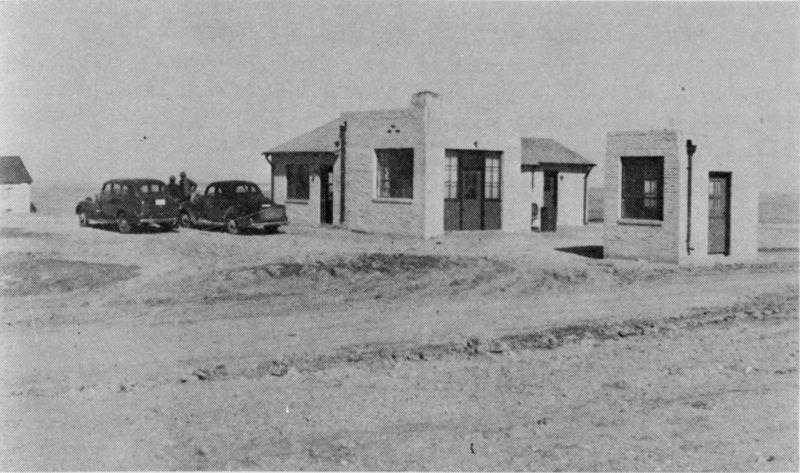
Figure 21 PINNACLES RANGER STATION AND CHECKING STATION, 1941
Completed in 1941, the ranger station also served as quarters until January 1965 when the new Pinnacles ranger station-residence was completed. The checking station was removed about 1958 to make way for road improvement, and the old ranger station was razed in April 1967.[163]
The problem of stock grazing in the national monument grew increasingly worse during the 1940’s. The acting custodian complained early in 1940:
Until the boundary is fenced and we are in a better position to know what is private and what is monument land, there appears to be very little that can be done to prevent this.[166]
In December 1941 he wrote in a similar vein:
During past winters it has been the practice of local stockmen to allow herds of horses and cattle to drift into the monument area to graze unrestrictedly over public as well as private lands and along the monument highways. There is such a large amount of private and county-owned land within the monument boundaries (31,000 acres out of a total of 150,000) that it is difficult to restrain stock from grazing on National Park Service land as well as on the land that is owned or leased by private individuals.[167]
It soon became obvious that Badlands National Monument would be a popular attraction because of its location near U.S. Highways 14 and 16, both well-known national highways going through the Black Hills. In 1941 there were 70.02 miles of road in the national monument. Of this, 46 61.52 miles were constructed by the state and 8.5 miles by the federal government; 29.87 miles were graveled and 40.15 were dirt roads.[168]
Although the roads through the area were only partially developed, thousands of travelers turned off the through highways to view the scenic Badlands.
Stricklin reported in September 1941:
More than a quarter of a million visitors had passed through Badlands National Monument by the close of the travel season on September 30, representing an increase of approximately 30 percent over the previous year, for the period during which an actual count was made.[169]
The entrance of the United States into World War II in December 1941 had a great impact on the area and its operations. Since many of the CCC enrollees would be absorbed into the armed forces, the project work soon came to an end. The acting custodian reported in the spring of 1942, “On March 25, after two years and five months of productive work in Badlands National Monument, CCC Camp Badlands, NP-3 [located at Cedar Pass], was abandoned.”[170] Work was continued on several projects undertaken at Camp Badlands by a CCC side camp with the view toward completing the projects or leaving them “in such condition that the facilities involved may be used, and the materials, all of which have been on hand for some time, may be protected against deterioration and loss.”[171] However, the side camp was also closed in the following June, leaving practically all of the construction projects in various states of completion.[172] In December 1942 most of the CCC buildings at Cedar Pass were dismantled and removed by the armed services.[173]
Another result of the nation’s entrance into the war was a sharp drop in visitors to the Badlands. Stricklin wrote in June 1942 that “Most of these visitors appeared to be genuine vacationists ... [who] had a vacation coming, and were trying to get it in before gas rationing became nation-wide.”[174] He estimated that travel in March 1943 was 87 percent under that for March 1942, and that “All foreign [out-of-state] visitor cars stopping for information were headed for defense jobs, or were military personnel, changing their headquarters from one part of the country to another.”[175] The effect of the war on travel to the national monument is reflected in the travel figures of the area for the years from 1941 to 1945. (See Appendix A.)
Efforts at the national monument during the war were devoted largely to preventive maintenance. Changing his headquarters from Pinnacles to Cedar Pass in June 1943, Stricklin was able to give closer attention to the headquarters area.[176] Such routine tasks as filling washouts, cleaning ditches, reclaiming gravel, cutting roadside weeds, repairing guard rails, cleaning up debris, and temporary patching of roads occupied most of the staff’s time. Other tasks, such as repairing water lines, painting signs, keeping the buildings in repair, and servicing and repairing the area equipment also required much attention.[177] The cottage that the custodian and his family rented from Millard at Cedar Pass was destroyed by fire on November 27, 1943.[178]
47
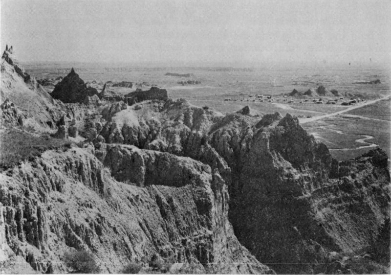
Figure 22 CEDAR PASS, June 1950
The buildings of Cedar Pass Lodge can be seen behind the white frame structure, which served as a visitor center and headquarters until 1959. Remnants of two spires on Vampire Peak remain on the left. It was observed on November 22, 1950, that one of the two spires of this famous landmark had fallen, apparently during a thunder storm.[189]
During the ten years following the end of World War II, there was slow progress in the area’s development. Work on the custodian’s residence at Cedar Pass, begun in 1941, was completed in 1946.[179] Early in 1953 two additional houses, both prefabricated, were completed.[180] In January 1948 commercial power was brought to Cedar Pass and Interior with the completion of a single-phase power line by the Rural Electrification Administration.[181] The Northwestern Bell Telephone Company extended telephone service to the national monument headquarters in September 1952.[182] (This service was officially taken over by the Golden West Telephone Cooperative, Inc., in October 1960.)[183]
During the travel seasons of 1946 and 1947 there was much adverse criticism of the national monument roads. The maintenance equipment was in poor condition and usually undergoing repairs when most needed.[184] In the summer of 1948 about 4 miles of road was black-topped between the Cedar Pass junction and Norbeck Pass; this represented the first paving of U.S. Route 16A in the national monument.[185] The present northeast entrance road, about 3½ miles long, was completed in October 1951. It opened up a new area of the Badlands known as the Window Section.[186] This road was made possible by the donation in 1946 of a 160-acre, strategically located land parcel by Mr. Ben Millard who had purchased it from Jackson County in March 1941 for this purpose.[187]
During the late 1940’s and early 1950’s buildings constructed as temporary 48 structures in the ERA and CCC period were remodeled and continued in use for headquarters and utility purposes.[188]
Both the grazing and the land ownership problems at the national monument were compounded by the war. With increased rainfall in the region during the decade of the 1940’s and the rising price of beef, the situation of the ranchers greatly improved. Under a plan suggested by Congressman Case in January 1943 to help in the “Beef for Victory Program,” the Service authorized for the first time in April the issuance of grazing permits on federally owned grasslands within the national monument. Under this program, the lands were divided into seven grazing units. An orderly grazing plan was established with the cooperation of the Soil Conservation Service.[190] Stricklin was able to identify and locate all cattle and sheep outfits that claimed to be using the national monument lands in conjunction with their SCS allotments.[191] Following the war authorized grazing remained one of the area’s major management problems for over a decade.
Stricklin wrote about an interesting sidelight of the grazing problem:
The roundup and disposal of several hundred head of unclaimed and so-called wild horses in the Sage Creek basin was a source of much concern on the part of both ranchers and the Custodian, the ranchers claiming the wild stallions were enticing away their mares. The Custodian’s concern was partly because of the damage these herds were doing to the range, but largely because it was practically the only program of any kind on which the National Park Service and the ranchers could even remotely agree. Several roundups were collaborated in, during which the herds were drastically reduced. Airplanes were used on at least one of the roundups to flush horses out of the canyons and keep them from breaking back on their route to Scenic and the loading chutes. Jack and Mamie Close, ranchers on Quinn Table, were the leaders among the ranchers in this work.[192]
Feral horses were eventually eliminated through roundups and returned to their owners. The last roundup took place in the national monument in 1963.[193]
With the improvement of their lot, many ranchers who had been destitute only a few years earlier were in a position to purchase county lands within the national monument boundary. The custodian reported in April 1943 that practically all such land within the boundary was leased for grazing and that much of it was recently bought by sheep and cattle ranchers.[194] In 1946 Stricklin reported a considerable change in land ownership where much of the land formerly controlled by Pennington County had passed into private ownership.[195] Later the same year Jackson County auctioned all of its 3,000 acres of land within the boundary to private individuals. Practically all of the 14,000 acres which was owned by the two counties two years earlier had passed into private ownership.[196]
The location of the boundary had been a subject of discussion since the national monument was established in 1939. The area contained a 49 large acreage of grassland which the Soil Conservation Service believed should be released for grazing purposes. There was also overlapping jurisdiction between the two federal agencies.[197]
After several years of study, the NPS and the SCS arrived at an understanding on the national monument boundary and mutual land problems. In 1946 the two agencies signed an agreement known as Recommended Program of Procedure for boundary adjustment of Badlands National Monument. The NPS agreed:
(1) to transfer to the Soil Conservation Service NPS lands outside the existing national monument boundary in order to compensate for 1,220 acres the SCS had turned over for inclusion in the national monument prior to its establishment in 1939;
(2) to transfer to the SCS equivalent lands (computed on a livestock-carrying-capacity basis) for lands that were to be acquired from the SCS by the NPS as the result of revised boundary studies;
(3) to transfer to the SCS federal lands which the NPS planned to eliminate from the national monument to use in exchange for non-federal lands remaining in the national monument after the boundary changes were made.[198]
The plan made it possible to transfer, without legislation, 3,678.19 acres of NPS lands lying outside the park boundary to the SCS. This was done by order of the Secretary of the Interior in July 1949.[199] These lands were acquired under the Resettlement Administration program and, in 1936 were transferred to the NPS. When Badlands National Monument was established in 1939, these lands were not within the boundary.[200]
In order to carry out the main objectives of the plan, Congressional action was necessary. In 1950 bills (H.R. 7342 and S. 3081) were introduced in the 81st Congress by Representative Case and Senator Chandler Gurney to implement the proposed land exchange. H.R. 7342 was passed by the House without amendment, but later the bill died in the Senate. The senate bill (S. 3081) was not considered.
In 1951 Senator Francis H. Case, who had just been elected to that office, and Congressman E.Y. Berry introduced identical bills (S. 896 and HR. 3540) in the 82nd Congress. These were similar to the ones proposed a year earlier. Berry’s bill passed the House on July 2, 1951, without amendment. The House Act was referred to the Senate Committee on Interior and Insular Affairs, which recommended that section five of H.R. 3540 be dropped. This section would have provided authority to include 4,000 acres of the Pine Ridge Indian Reservation in the Sheep Mountain area provided certain conditions were met. The committee believed “that a satisfactory solution should be worked out with the Tribal Council of the Oglala Sioux Tribe of Indians, and any others interested, before legislation with regard to these lands is enacted.”[201] The bill in its amended form, including another minor change recommended by the committee, passed the Senate on January 24, 1952.[202]
50
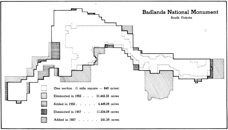
Figure 23 AREA CHANGES IN BADLANDS NATIONAL MONUMENT[203]
Area authorized in 1929 (dashed line) 50,830.40 acres
Area upon establishment in 1939 154,119.46 acres
Area after changes of 1952 122,642.52 acres
Area after changes of 1957 (heavy line) 111,529.82 acres
Acreage figures are latest available and may be different from figures which were current during each of the four times the park boundary has been redesignated. Because of these acreage revisions, additions to and deletions from the park do not total correctly.
Badlands National Monument
South Dakota
One section (1 mile square—640 acres)
Eliminated in 1952 31,442.52 acres
Added in 1952 4,449.29 acres
Eliminated in 1957 11,234.09 acres
Added in 1957 241.39 acres
51
Shortly afterwards on February 8, telegrams were sent to Congressmen Berry, Senator Case, and Senator Karl Mundt by the executive committee of the tribal council of the Oglala Sioux Tribe. The messages urged the congressmen to do their best to get Section 5 restored so it would be possible for the tribe to negotiate with the federal government for exchange of the land in the Sheep Mountain area for other lands.[204] The House, however, did not heed this resolution but voted instead to concur with the Senate’s amended version. The bill became Public Law 328 after being signed by President Harry S Truman on May 7, 1952.[205]
Under this law, the Secretary of the Interior was authorized to adjust and redefine at his discretion the exterior boundary of the national monument by appropriate reductions or additions. The law specified, among other things, that the adjusted area could not exceed the existing 154,119 acres.[206] (An official figure of 150,103.41 acres was used as the total acreage of the area at the time it was proclaimed as a national monument in 1939. A revised figure, listing 154,119.46 acres for the same area, was used as the total acreage from about 1943 until October 1952.[207])
Immediately after the bill became law, proposed boundary changes received considerable attention. Some believed that the area of the national monument should be reduced. A strong supporter of this view was the South Dakota Stock Growers Association. It was the organization’s belief that the size could be reduced by about one-half without destroying any of its scenic value. They estimated that 3,000 head of cattle would be without grass if the NPS carried through its plan to fence the area and eliminate grazing from the national monument. One of the biggest problems was the large acreage of private lands located within its boundary. Many ranchers believed that these lands ought to be eliminated “from the Badlands National Monument wherever a reasonable boundary adjustment can be made.”[208] Others contended “that all of the grassland west of Pinnacles [Sage Creek Basin] could be removed from the Park and that such removal would in no way destroy the attraction to the tourist.”[209]
A 1953 memorandum from the Regional Director to NPS Director Conrad L. Wirth explained how Sage Creek Basin had become largely government-owned:
Sage Creek Basin was a submarginal waste in the 1930’s due to prolonged and severe drought conditions and considerable acreages of private lands were acquired by the Resettlement Administration in connection with its submarginal land program.... Other private parcels became tax delinquent and were ultimately sold to private owners by Pennington County in the 1940’s. Because of favorable climatic conditions of the past several years, the basin has recovered from its condition of the 1930’s; it now contains a considerable acreage of good grasslands.... We venture the opinion that had vegetative conditions of the basin in the 1930’s resembled those of today, a submarginal land program would not have been undertaken so far as the basin is concerned.[210]
Owing to the great interest generated by the proposed boundary 52 changes, the NPS issued a statement in July 1952 giving reasons why it would not be “advisable to eliminate from the Monument the grasslands west of the Pinnacles, as suggested by the South Dakota Stock Growers Association.”[211] It said in part that
These flatter lands with their cover of native grasses and wildflowers, typical of the surrounding prairie country, are valuable for park and wildlife purposes. The preservation of this relatively small exhibit of native grass is an important responsibility in itself, since no comparable section of the Great Plains has been set apart to be preserved in its natural condition.[212]
The statement also indicated that about 31,700 acres of other lands were to be eliminated from the national monument, including more than 12,000 acres of privately owned lands. It indicated that the Soil Conservation Service agreed to these revisions and that they were “the same as those which the Congress considered when it authorized boundary revisions by enacting Public Law 328.”[213]
On October 3, 1952, Assistant Secretary of the Interior Joel D. Wolfsohn issued an order revising the boundary of the national monument. The order showed that 30,802.52 acres, more or less, were “hereby transferred from the Department of the Interior to the Department of Agriculture for use, administration, and disposition in accordance with the provisions of Title III of the Bankhead-Jones Farm Tenant Act....” This reduced the size of Badlands National Monument, according to the order, to 121,883.12 acres.[214]
The Order was performed to provide lands for the Soil Conservation Service to enable those persons having private land in the monument to trade for Soil Conservation Service lands outside the monument, and to make a few administrative adjustments in the monument boundary.[215]
However, discrepancies in the land records led the NPS to investigate the status of lands within the former boundary.[216] By late 1953 it was found that 31,442.52 acres were eliminated from the national monument by the October 3 order instead of 30,802.52 acres. Of these 12,916.32 acres were private lands; the remaining 18,526.20 acres were transferred to the Soil Conservation Service of the Department of Agriculture.[217]
There were also lands totaling about 4,449 acres added to the national monument by the October 3 order; these lands included
“2,581.88 acres of public domain, 336.88 acres of purchased land, 981.79 acres of Soil Conservation Service land and 548.56 acres of private land.... The net result of the boundary adjustments was a loss of 26,993.23 acres of land in Badlands National Monument.”[218]
Even before the October 3 order was enacted there was already talk about further reduction of the area boundary. In a memorandum dated December 5, 1952, Director Wirth wrote to the Regional Director in charge of Badlands National Monument:
53
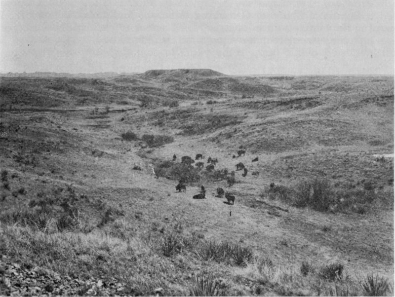
Figure 24 A PORTION OF SAGE CREEK BASIN
In 1953 over 25,000 acres were recommended by the NPS for deletion from this section of the national monument.[219] Later, studies revealed that the area should be retained. Today it is home for bison, deer, pronghorn, prairie dogs, and other animals. Sage Creek Primitive Campground is located in its northwest section.
The basis for a final solution [of the boundary problem at Badlands National Monument] lies in a reassessment and restatement of Monument objectives and significance. If it is found, as appears likely, that our chief concern and purpose should be with the badlands formations, then the boundaries should be drawn accordingly, with due regard for badlands protection, interpretation and attendant development needs. If we are to retain some or all of the grasslands, we must have strong and valid justification for doing so and be prepared to disclose and defend what specific Monument purposes and uses they are to serve.[220]
In order to determine if the grasslands west of Pinnacles should be kept, the NPS contracted with a number of prominent scientists to make studies of the area in 1953. Dr. Theodore E. White, a paleontologist with the Smithsonian Institution, determined in June 1953 whether or not potentially fossiliferous areas would be excluded by proposed boundary readjustments.[221] Late that summer archeological investigations were undertaken by Archeologist Paul L. Beaubien of the NPS Regional Office in Omaha, Nebraska. He recorded some 30 prehistoric Indian sites and one historic Indian site believed to have been used by Chief Big Foot’s band a few days before the infamous battle at Wounded Knee in December 1890.[222]
54
Professor F.W. Albertson of Fort Hays Kansas State College submitted a Report of Study of Grassland Areas of Badlands National Monument in September. In brief he said, “it seems to me that the Park Service has an extremely interesting area, which should be preserved for all interested public through the years to come.”[223]
Meanwhile, support grew for retention of the boundaries as spelled out by the October 3, 1952, secretarial order. The Rapid City Chapter of the Izaak Walton League of America, the South Dakota State Highway Commission, the South Dakota Department of Game, Fish and Parks, the Black Hills and Badlands Association, and prominent local persons, including Sid Soma, Dr. G.W. Mills, Ted Hustead, and Leonel Jensen, all from the town of Wall, were but a few of the many who advocated retention of the present boundary.[224]
Although the South Dakota Stock Growers Association and some local ranching interests continued to advocate “the transfer of administration of all grazing lands within the monument not needed for road and development purposes,” it became evident to these people that opposition was building up against further acreage reduction in the park.[225]
In April 1954 the NPS recommended no boundary changes until the problem was explored further. Director Wirth said:
it seems apparent that there is a very considerable number of people ... which strongly support the retention of the Badlands National Monument not only as a striking example of geological formations, with areas of paleontological interest, but also for preservation of a segment of the plains grassland and native wildlife as added attractions. On the other hand, there is also a difficult problem of inholdings and grazing complications, with strong sentiment from the livestock owners for a reduction of the Monument.[226]
He recommended, among other things, that exchanges of private land inside the boundary for federal lands outside be pushed vigorously, and that Dr. Adolph Murie, NPS Biologist, should study the wildlife possibilities of the national monument.[227]
In his report Dr. Murie said:
Badlands National Monument has national significance, first of all because it is a sample of the Badlands. The values of this monument are of outstanding significance in the fields of geology, paleontology, archeology, and biology. The eroded terrain has scenic value for many, and in Sage Creek Basin and in the section north of Cedar Pass one finds the atmosphere of the early scene, when this country was far beyond the frontier....
In Sage Creek Basin we have an opportunity to preserve the prairie dog-blackfooted ferret community, with many other associated species of the region.... Likewise the rare kit fox may possibly be preserved in the basin. The value of Sage Creek Basin for preserving these rare native species is contingent on size and its present size is none too large....
55
Concerning boundaries in general over the monument it appears that any eliminations would be harmful to public values. Only in minor details, in connection with land adjustments, should any territory be sacrificed. Sage Creek Basin, especially, should not be reduced....[228]
Also during the summer of 1954, the NPS requested Dr. James D. Bump, Director of Museum of Geology of the South Dakota School of Mines and Technology at Rapid City, to make a geological and paleontological appraisal of Badlands National Monument. Quotations from his report point out his strong feelings for the area:
The Big Badlands of South Dakota, from a paleontological standpoint, probably constitutes the richest Oligocene region in the world.... [The quantity of] paleontological materials given up to man over the past 100 years is of astounding proportions. This prehistorical treasure represents more than 250 species of the vertebrate life of thirty million years ago....
The Badlands National Monument is a part of the greatest badland-eroded section in North America.... I can think of no other geographic area of like-size that has the unusual natural beauty, the undisturbed plant and animal life and the wealth of scientific information to offer the public....[229]
He ended his report by making a number of recommendations, some of which follow:
The present boundaries must remain intact. Removal of any lands, except perhaps some thin scattered fringes, would seriously cripple future development and greatly reduce the attractiveness of the Monument....
Under no circumstances should any part of the Sage Creek Basin be withdrawn. Its scientific and natural value cannot be overestimated and it is my opinion that this section will in the future become one of the most interesting and educational of the entire Monument.[230]
As a result of Dr. Murie’s wildlife study and Dr. Bump’s geological and paleontological appraisal, the Service began formulating definite ideas in April 1955 concerning further revision of the boundary. An elimination of 11,124 acres including 4,234 acres of privately owned lands was proposed. This is only about one-third of the 32,000 acres which was being widely talked about as a possible reduction in size during 1953. The larger reduction would have included much of the grasslands west of Pinnacles. Addition of 4,460 acres, including 3,954 acres of Pine Ridge Indian Reservation lands and 246 acres of Department of the Army lands located on the Indian reservation, was also proposed. Net reduction in area would be about 6,664 acres.[231]
Since the mid-1930’s there have been various suggestions that a road be constructed to connect Sage Creek Basin with the Sheep Mountain locality. Although it was not in the master plan for the national monument in the 1950’s, planning for the ultimate boundary was done so that the road could be built if ultimately needed.[232] However, Dr. Murie recommended against the road proposal in his report.[233]
56
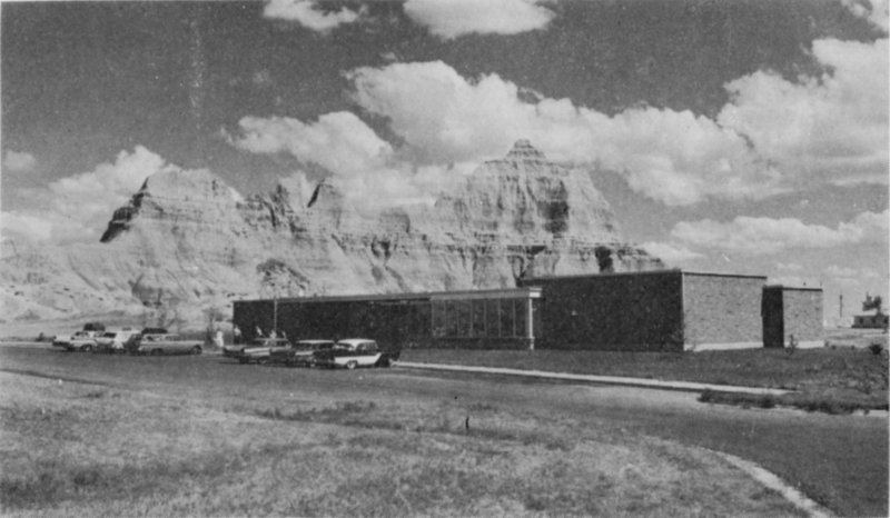
Figure 25 BADLANDS NATIONAL MONUMENT VISITOR CENTER
Dedicated in 1959, the building houses the national monument’s administrative offices, exhibits on the Badlands, and a small theater in which there are narrated slide programs on the highlights of the Badlands. The facility is open all year.
On April 12, 1956, an open meeting was held in Wall, South Dakota, to discuss proposed boundary changes with ranchers, stockmen, and local businessmen. No opposition to the proposals was voiced. The meeting also provided an opportunity for discussion of development plans, including fencing and grazing matters.[234]
On March 22, 1957, Acting Secretary of the Interior Hatfield Chilson issued an order eliminating 11,234.09 acres from the national monument, of which about 4,000 acres were private land. The total area of Badlands National Monument was fixed at 111,529.82 acres. This also included an addition of 240 acres of federal land which, among other things, increased the utility area at headquarters and provided a much needed disposal area. An additional 1.39 acres of federal land, located along the White River three miles south of headquarters, were added, since water storage tanks and a water pump, all part of the area’s water system, are located there. More than 7,000 acres of the 11,234.09-acre reduction were transferred to the Department of Agriculture, under provisions of the Bankhead-Jones Farm Tenant Act, and became available for exchange for private land remaining inside the new boundary. As a result of the secretarial order, there was a net reduction of 10,992.70 acres in the size of the national monument. The new boundary included 98,486.39 acres in federal ownership and 13,043.43 acres of non-federal land.[235] Since then, the Service has acquired title to 6,356.71 acres of the non-federal land within the boundary. As of December 1967 there were 104,843.10 acres of federal land and 6,686.72 acres of non-federal land within the boundary of Badlands National Monument.[236]
On January 2, 1954, the Secretary of Agriculture transferred the Land Utilization Program, including lands in the vicinity of the national monument, 57 from the Soil Conservation Service to the U.S. Forest Service.[237] This, in part, prompted a Program of Procedure for Land Exchanges, a revision of the Recommended Program of Procedure, to be drafted. The new agreement was signed in September 1954 by officials of both services. It states in part that all future land exchanges are to be handled by the Forest Service. This includes exchanges with private parties who own land inside the national monument boundary. One objective of such land exchanges is to eliminate all non-federal lands from within Badlands National Monument.[238] Since 1954 elimination of such lands has come about largely through exchanges, although in a few instances actual purchases were made.
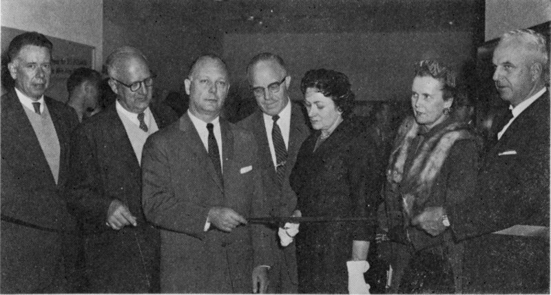
Figure 26 RIBBON-CUTTING CEREMONY AT BADLANDS NATIONAL MONUMENT DEDICATION, SEPTEMBER 16, 1959
Left to Right: NPS Regional Director Howard Baker, Region Two (now Midwest Region); Conrad Wirth, NPS Director; Fred Seaton, Secretary of the Interior; Congressman E.Y. Berry; Mrs. George H. Sholly, widow of Badlands National Monument Superintendent; Mrs. Ralph Herseth; and Governor Ralph Herseth of South Dakota.
Concurrently with boundary adjustments, the NPS gave considerable thought to a grazing management plan for the area whereby grazing might be eliminated without serious hardship to the local ranchers. As a result the Service presented a plan in May 1948 to grazing permittees outlining a schedule for the gradual termination of grazing on federally owned national monument lands by December 31, 1961.[239]
59