Front matter (continued 3)
Reading edition
Till recently very few Palæolithic implements had been recorded as found in the Isle of Wight. In the Memoir of the Geological Survey (1889) only one such is recorded, found in a patch of brick earth near Howgate Farm, Bembridge.[18] A few more implements, which almost certainly came from this brick-earth, have been found on the shore since. In recent years a large number of Palæolithic implements have been found at Priory Bay near St. Helen's. They were first observed on the beach by Prof. E. B. Poulton, F.R.S., in 1886, and were traced to their source in the gravel in the cliff by Miss Moseley in 1902. From that time, and especially from 1904 onwards, many have been found by Prof. Poulton, by R. W. Poulton (and others). Up to 1909 about 150 implements had been found, and there have been more finds since.[19]
The most important finds, besides those at Priory Bay, have been those of Mr. S. Hazzledine Warren at Freshwater, especially in trial borings in loam and clay below the surface soil in a depression of the High Downs, south of Headon Hill, at a level of about 360 ft. O.D., in which a number of Palæolithic tools, flakes, and cores were found[20]. Isolated implements have been found in recent years in various localities in the Island. There are references to finds of implements at different times in the past, but the descriptions are generally too vague to conclude certainly to what date they belong. Much of the gravel used in the Island comes from the angular gravel on St. Boniface Down, or the high Plateau Gravel of St. George's Down; but in the lower gravels and associated brick earth, it is highly probable that more remains of Palæolithic man will yet be found in the Island, and quite possible that such have been found in the past, but for want of accurate descriptions of the circumstances of the finds are lost to us.
We must pass on to the men of the Neolithic or later stone age. The Palæolithic age was of very great duration, much longer than all succeeding human history. Between Palæolithic and Neolithic times there is in England a large gap. In France various stages have been traced showing a continual advance in culture. In England little, if anything, has been found belonging to the intermediate stages. Such remains may yet be found in caves, or in lower river gravels, now buried below the alluvium. The gap between Palæolithic and Neolithic is marked by the great amount of river erosion which took place in the interval. Palæolithic implements are found in gravels formed when the rivers flowed some 100 feet above their present courses. Take, e.g., the Itchen at Southampton. After the 100 foot gravels were deposited the river cut down, not merely to its present level, but to an old bed now covered up by various deposits beneath the river. After cutting down to that bed the river laid down gravels upon it; and then—the land standing at a higher level than to-day—the river valley and the surrounding country were covered by a forest, which, as the climate altered and became damper, was succeeded by the formation of peat. The land has since sunk, and the peat, in parts 17 ft. thick, is now found under Southampton Water, covered by estuarine silt. The Empress Dock at Southampton was dug where a mud bank was exposed at low water. The mud bank was formed of river silt 12 to 17 feet thick. Below this was the peat, resting on gravel. On the gravel horns of reindeer were found. In the peat were large horn cores of the great extinct ox, Bos primigenius, also horns of red deer, and also in the peat were found neolithic flint chips, a circular stone hammer head, with a hole bored through for a wooden handle, and a large needle made of horn. Here, at a great interval of time after Palæolithic man, as we see by the history of the river we have just traced, we come to the new race of men, the Neolithic.
When Neolithic man appeared the land stood higher than at present, though not so high as during great part of the Pleistocene. Britain was divided from the Continent, but the shores were a good way out into what is now sea round the coasts, and forests clothed these further shores. Remains of these, known as submerged forest, are found below the tide mark round many parts of our coast. Peat as at Southampton Docks, is found under the estuarine mud off Netley. The wells at the Spithead Forts show an old land surface with peat more than 50 feet below the tide level. The old bed of the Solent river lies much lower still—124 feet below high tide at Noman's Land Fort; this channel was probably an estuary after the subsidence of the land till it silted up with marine deposits to the level on which the submerged forest grew.
When the Solent and Southampton Water were wooded valleys with rivers flowing down the middle, the Isle of Wight rivers were tributaries to the Solent river, and the forest, as might be expected, extended up their valleys, and covered the low ground of the Island. Under the alluvial flats are remains of buried forests. In digging a well at Sandford in 1906 large trunks of hard oak were found blocking the sinking of the well. When the land sank the sea flowed up the river valleys, converting them into strait and estuary, and largely filling up the channels with the silt, which now covers the peat. In the silt of Newtown river are found bones of Bos primigenius, which was found with the Neolithic remains in the peat of Southampton docks.
The remains of Neolithic man are not only found in submerged forests, but over the present surface of the land, or buried in recent deposits. He has left us the tombs of his chiefs, known as long barrows—great mounds of earth covering a row of chambers made of flat stones, such as the mounds of New Grange in Ireland, and the cromlechs or dolmens still standing in Wales and Cornwall. These consist of a large flat or curved stone—it may be 14 feet in length,—supported on three or four others. Originally a great mound of earth or stones was piled on top. These have generally been removed since by the hand of later man. The stones have been taken for road metal, the earth to lay on the land. The great cromlech at Lanyon in Cornwall was uncovered by a farmer, who had removed 100 cart loads of earth to lay on his stony land before he had any idea that it was not a natural mound. Then he came on the great cromlech underneath. Another form of monument was the great standing stone or menhir, one of which, the Longstone on the Down above Mottistone still stands to mark the tomb of some chieftain of, it may be, 4,000 years ago.
The implements of Neolithic man are found all over England, the smooth polished axe head, commonly called a celt (Lat. celtis, a chisel), the chipped arrow head, the flaked flint worked by secondary chipping on the edge into a knife, or a scraper for skins; and much more common than the implement, even of the simplest description, are the waste flakes struck off in the making. Very few stone celts have been found in the Isle of Wight. The flakes are extremely numerous, and a scraper or knife may often be found. They are turned up by the plough on the surface of the fields, in the earth of which they have been preserved from rubbing and weathering. They have however, acquired a remarkable polish, or "patina"—how is not clearly explained—which distinguishes their surface from the waxy appearance of newly-broken flint. In places the ground is so covered with flakes that we can have no doubt that these are the sites of settlements. The implements were made from the black flints fresh out of the chalk, and we can locate the Neolithic flint workings. In our northern range of downs where the strata are vertical the layers of flint in the Upper Chalk run out on the top of the downs, only covered with a thin surface soil. In places where this soil has been removed—as in digging a quarry—the chalk is seen to be covered with flakes similar to those found on the lower ground, save that they are weathered white from lying exposed on the hard chalk, instead of on soft soil into which they would gradually sink by the burrowing of worms. It is probable that these flakes would be found more or less along the range of downs under the surface soil.
In places on the Undercliff have been found what are known as Kitchen Middens—heaps of shells which have accumulated near the huts of tribes of coast dwellers, who lived on shellfish. One such was formerly exposed in the stream below the old church at Bonchurch, and is believed to extend below the foundations of the Church.
After a long duration of neolithic times a great step in civilisation took place with the introduction of bronze. Bronze implements were introduced into this country probably some time about B.C. 1800-1500; and bronze continued to be the best material of manufacture till the introduction of iron some two or three centuries before the visit of Julius Caesar to these Islands. To the early bronze age belong the graves of ancient chieftains known as round barrows, of which many are to be seen on the Island downs. Funeral urns and other remains have been found in these, some of which are now in the museum at Carisbrooke Castle. Belonging to later times are the remains of the Roman villa at Brading and smaller remains of villas in other places; and cemeteries of Anglo-Saxon date, rich in weapons and ornaments, which have been excavated on Chessil and Bowcombe Downs. But the study of the remains of ancient man forms a science in itself—Archæology. In studying the periods of Palæolithic and Neolithic man we have stood on the borderland where Geology and Archæology meet. We have seen that vast geological changes have taken place since man appeared on earth. We must remember that the geological record is still in process of being written. It is not the record of a time sundered from the present day, but continuous with our own times; and it is by the study of processes still in operation that we are able to read the story of the past.
Chapter XIII.
THE SCENERY OF THE ISLAND—Conclusion.
After studying the various geological formations that enter into the composition of the Isle of Wight, and learning how the Island was made, it will be interesting to take a general view of the scenery, and see how its varied character is due to the nature of its geology. It would hardly be possible to find anywhere an area so small as this little Island with such a variety of geological formations. The result is a remarkable variety in the scenery.
The main feature of the Island is the range of chalk downs running east and west, and terminating in the bold cliffs of white chalk at Freshwater and the Culvers. Here we have vertical cliffs of great height, their white softened to grey by weathering and the soft haze through which they are often seen. In striking contrast of colour are the Red Cliff of Lower Greensand adjoining the Culvers, and the many-coloured sands of Alum Bay joining on to the chalk of Freshwater. The summits of the chalk downs have a characteristic softly rounded form, and the chalk is covered with close short herbage suited to the sheep which frequently dot the green surface. Where sheets of flint gravel cap the downs, as on St. Boniface, they are covered by furze and heather, producing a charming variation from the smooth turf where the surface is chalk. The Lower Greensand forms most of the undulating country between the two ranges of downs; while the Upper Greensand, though occupying a smaller area, produces one of the most conspicuous features of the scenery—the walls of escarpment that form the inland cliffs between Shanklin and Wroxall, Gat Cliff above Appuldurcombe, the fine wall of Gore Cliff above Rocken End, and the line of cliffs above the Undercliff. To the Gault Clay is due the formation of the Undercliff—the terrace of tumbled strata running for miles well above the sea, but sheltered by an upper cliff on the north, and in parts overgrown with picturesque woods. The impervious Gault clay throws out springs around the downs, which form the headwaters of the various Island streams. The upper division of the Lower Greensand, the Sandrock, forms picturesque undulating foothills, often wooded, as at Apsecastle, and at Appuldurcombe and Godshill Park. On a spur of the Sandrock stands Godshill Church, a landmark visible for miles around. At Atherfield we have a fine line of cliffs of Lower Greensand, while the Wealden Strata on to Brook form lower and softer cliffs.
To the north of the central downs the Tertiary sands and clays, often covered by Plateau gravel, form an extended slope towards the Solent shore, much of it well wooded, and presenting a charming landscape seen from the tops of the downs. This slope of Tertiary strata is deeply cut into by streams, which form ravines and picturesque creeks, as Wootton Creek, 200 feet below the level of the surrounding country. While much of the Island coast is a line of vertical cliff, the northern shores are of gentler aspect, wooded slopes reaching to the water's edge, or meadow land sloping gradually to the sea level. Opposite the mouths of streams are banks of shingle and sand dunes, forming the spits locally known as "dovers." Some of these, in particular, St. Helen's Spit, afford interesting hunting grounds for the botanist.
The great variety of soil and situation renders the Isle of Wight a place of interest to the botanist. We have the plants of chalk downs, of the sea cliff and shore, of the woods and meadows, of lane and hedgerow, and of the marshes. The old villages of the Island, often occupying very picturesque situations—as Godshill on a spur of the southern downs, Newchurch on a bluff overlooking the Yar valley, Shorwell nestling among trees in a south-looking hollow of the downs, Brighstone with its old church cottages and farmhouses among trees and meadows between down and sea—the old and interesting churches, the thatched cottages, the old manor houses of Elizabethan or Jacobean date, now mostly farm houses, for which the Island is famous, add to the varied natural beauty.
One of the most characteristic features of the southern coasts of the Island, should be mentioned, the Chines,—narrow ravines which cut inland from the coast through the sandstone and clays of the Greensand and Wealden strata, and along the beds of which small streams flow to the sea. Narrow and steep-sided,—the name by which they are called is akin to chink—they are in striking contrast to the more open valleys of the streams which flow into the Solent on the north shore of the Island. The most beautiful is Shanklin Chine. The cliff at the mouth of the chine, just inside which stands a picturesque fisherman's cottage with thatched roof, is 100 ft. high; and the chasm runs inland for 350 yds., to where a very reduced cascade (for the water thrown out of the Upper Greensand by the Gault clay is tapped at its source for the town supply) falls vertically over a ledge produced by hard ferruginous beds of the Greensand. Above the cascade the ravine runs on, but much shallower, for some 900 yards. The lower ravine has much beauty, tall trees rising up the sides, and overshadowing the chasm, the banks thickly clothed with large ferns and other verdure. Much wilder are the chines on the south-west of the Island. The cascade at Blackgang falls over hard ferruginous beds (to which the beds over which Shanklin cascade falls—though on a smaller scale—probably correspond). The chine above these beds, being hollowed out in the soft clays and sands of the Sandrock series, is much more open. Whale Chine is a long winding ravine between steep walls, the stream at the bottom making its way through blocks of fallen strata.
The cause of these chines seems to be the same in all cases. It may be noticed that Shanklin and Luccombe chines are cut in the floors of open combes,—wide valleys with gently sloping floors; and at each side of these chines is to be seen the gravel spread over the floor of the old valley. It can scarcely be doubted that these combes are the heads of the valleys of the old streams, which flowed down a gradual slope till they joined the old branch (or, rather the old main river)[21] of the Yar, flowing over land extending far over what is now Sandown Bay. When the sea encroached, and cut into the course of this old river, and on till it made a section of what had been the left slope of the valley, the old tributaries of the Yar now fell over a line of cliff into the sea. They thus gained new erosive power, and cut back at a much greater rate new and deeper channels; with the result that narrow trenches were cut in the floors of the old gently sloping valleys. The chines on the S.W. coast are to be explained in a similar way. They have been cut back with vertical sides, because the encroachment of the sea caused the streams to flow over cliffs, and so gave then power to cut back ravines at so fast a rate that the weathering down of the sides could not keep pace with it. The remarkable wind-erosion of these bare south-westerly cliffs by a sort of sand-blast driven before the gales to which that stretch of coast is exposed has already been referred to.
A few words in conclusion to the reader. I have tried to show you something of the interest and wonder of the story written in the rocks. We have seen something of the world's making, and of the many and varied forms of life which have succeeded each other on its surface. We have had a glimpse of great and deep problems suggested, which are gradually receiving an answer. Geology has the advantage that it can be studied by all who take walks in the country, and especially by those who visit any part of the sea coast, without the need of elaborate and costly scientific instruments and apparatus. Any country walk will suggest problems for solution. I have tried to lead you to observe nature accurately, to think for yourselves, to draw your own conclusions. I have shown you how to try to solve the questions of geology by looking around you at what is taking place to-day, and by applying this knowledge to explain the records which have reached us of what has happened in the past. You are not asked to accept the facts of the geological story on the word of the writer, or on the authority of others, but to think for yourselves, to learn to weigh evidence, to seek only to find out the truth, whether it be geology you are studying or any other subject, and to follow the truth whithersoever it leads.
TABLE OF STRATA
Recent.Peat and River Alluvium.
Pleistocene.Plateau Gravels: Valley Gravels and Brick-Earth.
TertiaryPliocene MioceneAbsent from the Isle of Wight.


Oligocene HamsteadMarine, Corbula Beds Freshwater & Estuarine. Bembridge BedsBembridge Marls Bembridge Limestone Osborne and St. Helen's Beds. Headon BedsUpper. Freshwater and Brackish Middle. Marine Lower. Freshwater and Brackish


Eocene Barton BedsBarton Sand. Barton Clay.
Bracklesham Beds. Bagshot Sands London Clay Plastic Clay (Reading Beds)
Mesozoic or SecondaryUpper Cretaceous White ChalkUpper Chalk (Chalk with flints) Middle Chalk (Chalk without flints) Lower ChalkA. plenus Marls Grey Chalk Chalk Marl Chloritic Marl Selbornian Upper GreensandChert Beds Sandstone and Rag Beds Gault Lower Cretaceous Lower GreensandCarstone Sandrock and Clays Ferruginious Sands Atherfield Clay Perna Bed WealdenShales Variegated Marls

FOR FURTHER STUDY.
Memoirs of the Geological Survey. General Memoir of the Isle of Wight, date 1889. New edition, entitled "A short account of the Geology of the Isle of Wight," by H. J. Osborne White, F.G.S., 1921, price 10s. The Memoirs are the great authority for the Geology of the Island: technical; books for Geologists. The New Edition is more condensed than the original, but contains much later research. Mantell's "Geological Excursions round the Isle of Wight," 1847. By one of the great early geologists. Long out of print, but worth getting, if it can be picked up second-hand.
Norman's "Guide to the Geology of the Isle of Wight," 1887, still to be obtained of Booksellers in the Island. Gives details of strata, and lists of fossils, with pencil drawings of fossils.
Other books bearing on the subject have been mentioned in the text and foot-notes.
An excellent geological map of the Island, printed in colour, scale 1 in. to the mile, full of geological information, is published by the Survey at 3s.
A good collection of fossils and specimens of rocks from the various strata of the Isle of Wight has recently been arranged at the Sandown Free Library, and should be visited by all interested in the Geology of the Island. It should prove a most valuable aid to all who take up the study, and a great assistance in identifying any specimens they may themselves find.
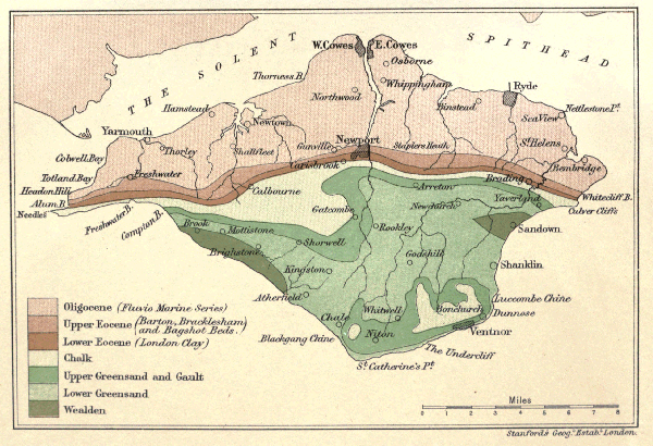
Click on map for larger view. Geological Map of the Isle of Wight
INDEX
Words in Italics refer to a page where the meaning of a
term is given.
Agates,
22
,
41
,
50
Alum Bay,
56-62
Ammonites,
32
,
34
,
39
,
44
Anticline
,
12
Astronomical Theory of Ice Age,
83
,
85
Atherfeld,
29
Avon River,
94
Barrows,
102
,
104
Barton,
61
Belemnites,
33
Bembridge Limestone,
65
— shingle at,
95
Benettites,
27
"Blue Slipper,"
15
Bonchurch,
50
,
103
Bos primigenius,
101
,
102
Botany,
106
Bracklesham,
59
,
60
Brading Harbour,
90
,
91
Bronze age,
103
Brook,
29
Building Stone,
39
,
65
Carstone,
26
,
35
Chalcedony,
22
,
41
,
50
Chale,
33
Chalk, divisions of,
45
,
51
,
52
— Marl,
45
— Rock,
45
Chalybeate Springs,
25
Chert,
39
Chloritic Marl,
44
Climate.
Coal,
8
,
61
Colwell Bay,
64
Compton Bay,
31
,
39
Conglomerate, modern,
25
"Crackers,"
32
Cretaceous.
Crioceras,
34
Current Bedding,
27
Cycads.
Denudation,
3
,
12
,
76
,
80
,
82
Dip
,
11
Echinoderms,
48
,
52
Eocene,
54
Erosion, marine,
4
" pre-Tertiary,
54
Escarpment
,
14
Faults, 13 Fault at Brook, 30 Flint, origin of, 47 " implements, 97 Flora, Alum Bay, 59 " Eocene, 58, 62 " Wealden, 18, 27 Foraminifera, 42, 61 Gat Cliff, 38 Gault, 37 Glacial Period, 77-85 Glauconite, 24, 39, 44 Gore Cliff, 39, 44 Greensand, Lower, 23-36 " Upper, 37 Gravels, 50, 79, 89, 93-95 Hamstead, 65, 67 Headon Hill, 62-64 Hempstead, see Hamstead. Hyopotamus, 69 Ice Age, 77-85 Iguanodon, 20 Insect Limestone, 67 Iron Ore, 22, 24 Iron pyrites, 22 Landslips, 25, 38 Limnæa, 63, 64, 66 Lobsters, Atherfield, 32 London Clay, 57 Luccombe, Landslip at, 25 Mammalian Remains, 66, 69 Mammoth, 77, 81 Marvel, 35 Medina, 93 Melbourn Rock, 45 Miocene, 69, 71, 76 Nautilus, 32, 45 Needles, 4 Neolithic Man, 100 Newtown River, 102 Nummulites, 61 Oligocene, 63 Palæolithic Man, 97 Perna Bed, 23, 31 Pine Raft, 29 Planorbis, 63, 64, 66 Plastic Clay, 57 Priory Bay, 99 Purbeck Marble, 16 Quarr, 65 Rag, 38 Rock (place), 35 Roman Villas, 104 St. Boniface Down, 50, 100, 105 St. George's Down, 79, 100 Sandown Anticline, 11-13, 89 Sandrock, 25, 35 Scaphites, 34 Scenery, 105
Sea Urchins, 48, 52, Shanklin Chine, 107 Solent, 94 Southampton Dock, 101 " Water, 94 Sponges in Flint, 47 Stone Age, 97 Strata, Table of, 110, 111 Strike, 11 Submerged Forest, 101 Swanage, 93 Syncline, 12 Table of Strata, 110, 111 Tertiary, 54 Totland Bay, 63, 95 Tufa, 45 Turtle, 58, 65, 68 Undercliff, formation of, 25, 38 Volcanic Action, 5 Wealden, 15 Whitcliff Bay, 56-67 Wood, Fossil, 8, 15, 18, 27, 29 Yar, Eastern, 89-91 Western, 92 Zones of Chalk, 51, 52
Printed by The Crypt House Press, Bell Lane, Gloucester.