Front matter (continued 2)
Reading edition
The Chalk Sea evidently abounded in siliceous organisms, and it cannot be doubted that it is from such organisms that the silica was derived, which has formed the masses of flint. Silica occurs in two forms—in a crystalline form as quartz or rock crystal, and as amorphous, i.e., formless or uncrystalline (also called opaline) silica. The siliceous skeletons of marine organisms are formed of amorphous silica. Flint consists of innumerable fine crystalline grains, closely packed together. Amorphous silica is less stable than crystalline, and is capable of being dissolved in alkaline water, i.e., water containing carbonate of sodium or potassium in solution. If the silica so dissolved be deposited again, it is generally in the crystalline form. It seems probable, therefore, that the amorphous silica of the skeletal parts of marine organisms has been dissolved by alkaline water percolating through the strata, and re-deposited as flint.
As the silica was deposited, chalk was removed. The large irregular masses of flint lying in the Chalk strata have clearly taken the place of chalk which has been removed. Water charged with silica soaking through the strata has deposited silica, and at the same time dissolved out so much carbonate of lime. Bivalve shells, originally carbonate of lime, are often replaced, and filled up by flint, and casts of sea urchins in solid flint are common, and often beautiful fossils. This process of change took place after the foraminiferal ooze had been compacted into chalk strata; and to some extent at any rate, there has been deposition of silica after the chalk had become hard and solid; for we find flat sheets, called tabular flint, lying along the strata, or filling cracks cutting through the strata at right angles. But in all probability the re-arrangement of the constituents of the strata took place in the main during the first consolidation, as the strata rose above the sea-level, and the sea-water drained out. A suggestion has been made by R. E. Liesegang, of Dresden, to explain the occurrence of the flints in the bands with clear interspaces between, which are such a marked feature of the Upper Chalk. He has shown how "a solution diffusing outward and encountering something with which it reacts and forms a precipitate, moves on into this medium until a concentration sufficient to cause precipitation of the particular salt occurs. A zone of precipitation is thus formed, through which the first solution penetrates until the conditions are repeated, and a second zone of precipitate is thrown down. Zone after zone may thus arise as diffusion goes on." He suggests that the zones of flint may be similar phenomena, water diffusing through the masses of chalk taking up silica till such concentration is reached that precipitation takes place, the water then percolating further and repeating the process.[8]
The precipitation of silica and replacement of the chalk occurs irregularly along the zone of precipitation, forming great irregular masses of flint, which enclose the sponges and other marine organisms that lay in the chalk strata. Where a deposit of silica has begun, it will probably have determined the precipitation of more silica, in the manner constantly seen in chemical precipitation; and it would seem that siliceous organisms as sponges have to some extent served as centres around which silica has been precipitated, for flints are very commonly found, having the evident external form of sponges.
It will be well to say something here of the history of the flints as the chalk which contains them is gradually denuded away. Rain water containing carbonic dioxide has a great effect in eating away all limestone rocks, chalk included. A vast extent of chalk, which formerly covered much of England has thus disappeared. The arch of chalk connecting our two ranges of downs has been cut through, and from the top of the downs themselves a great thickness of chalk has been removed. The chalk in the downs above Ventnor and Bonchurch is nearly horizontal. It consists of Lower and Middle Chalk; and probably a small bit of the Upper occurs. But the top of St. Boniface Down is covered with a great mass of angular flint gravel, which must have come from the Upper Chalk. The gravel is of considerable thickness, perhaps 20 ft., and on the spurs of the down falls over to a lower level like a table-cloth. It is worked in many pits for road metal. This flint gravel represents the insoluble residue which has been left when the Chalk was dissolved away.
On the top of the cliffs between Ventnor and Bonchurch, at a point called Highport, is a stratum of flint gravel carried down from the top of the down. The shore here is strewn with large flints fallen from the gravel. The substance of many of the flints has undergone a remarkable change. Instead of black or dull grey flint it has become translucent agate, of splendid orange and purple colours, or has been changed into clear translucent chalcedony. In the agate the forms of fossil sponges can often be beautifully seen. The colours are due to iron-charged water percolating into the flint in the gravel bed, but further structural changes have altered the form of the silica; chalcedony having a structure of close crystalline fibres, revealed by polarized light: when variously stained and coloured, it is usually called agate. Many of these flints, when cut through and polished, are of great beauty. The main force of the tides along these shores is from west to east; and so there is a continual passage of pebbles on the shore in that direction. The flints in Sandown Bay have in the main travelled round from here; and towards the Culvers small handy specimens of agates and chalcedonies rounded by the waves may be collected.
Photo 2
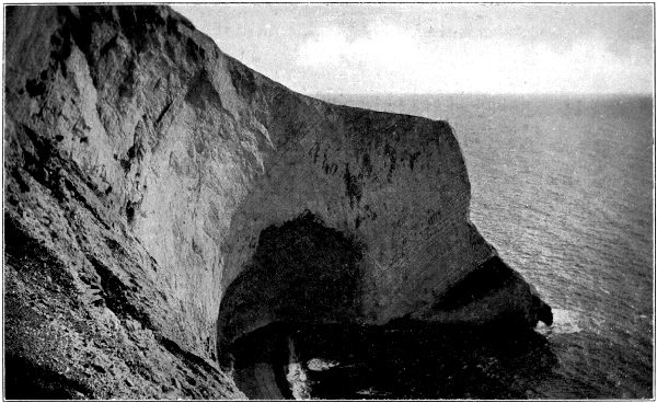
Photo by J. Milman Brown, Shanklin. Scratchell's Bay—Highly Inclined Chalk Strata
The extensive downs in the centre of the Island are largely overspread with angular flint gravel similarly formed to that of St. Boniface. Of other beds of gravel, which have been washed down to a lower level by rivers or other agency we shall have more to say later.
The Chalk strata in the Isle of Wight are of great thickness. In the Culver Cliff there are some 400 feet of flintless Chalk (Lower and Middle Chalk), and then some 1,000 feet of chalk with flints. There is some variation in the thickness of the strata in different parts of the Island, and the amount of the Upper strata, which has been removed by denudation, varies considerably. The average thickness of the white chalk in the Island is about 1,350 feet.[9] Including the Lower Chalk, the maximum thickness of the Chalk strata is 1,630 ft.
The divisions of the chalk we have so far considered depend on the character of the rock: we must say a word about another way of dividing the strata. It is found that in the chalk, as in other strata, fossils change with every few feet of deposit. We may make a zoological division of the chalk by seeing how the fossils are distributed. The Chalk was first studied from this point of view by the great French geologist, M. Barrois, who divided it into zones, according to the nature of the animal life, the zones being called by the name of some fossil specially characteristic of a particular zone. More recently Dr. A. W. Rowe has made a very careful study of the zones of the White Chalk, and is now our chief authority on the subject. The strata have been grouped into zones as follows:—
Zones.Sub-Zones.

Upper Chalk.Belemnitella mucronata. Actinocamax quadratus.

Offaster pilula.Offaster pilula Echinocorys depressus. Marsupites testudinarius.Marsupites. Uintacrinus.

Micraster cor-anguinum. Micraster cor-testudinarium. Holaster planus.
Middle Chalk.Terebratulina lata. Inoceramus labiatus.
Lower Chalk. Holaster subglobosusActinocamax plenus (at top).
Schloenbachia variansStauronema carteri (at base).
The method of study according to zoological zones is of great interest. The period of the White Chalk was of long duration, and the physical conditions remained very uniform. So that by studying the succession of life during this period we may learn much about the gradual change of life on the earth, and the evolution of living things.
We have seen that the whole mass of the chalk is made up mainly of the remains of living things,—mostly of the microscopic foraminifera. We have seen that sponges were very plentiful in that ancient sea. Of other fossils we find brachiopods—different species of Terebratula and Rhynchonella—a large bivalve Inoceramus sometimes very common; the very beautiful bivalve, Spondylus spinosus, belemnites, serpulæ; and different species of sea-urchin are very common. A pretty heart-shaped one, Micraster cor-anguinum, marks a zone of the higher chalk, which runs along the top of our northern downs. Other common sea urchins are various species of Cidaris, of a form like a turban (Gk. cidaris, a Persian head-dress); Cyphosoma, another circular form; the oval Echinocorys scutatus, which, with varieties of the same and allied species, abounds in the Upper Chalk, and the more conical Conulus conicus. The topmost zone, that of B. Macronata, would yield a record of exuberant life, were the chalk soft and horizontal. There was a rich development of echinoderms (sea urchins and star fishes), but nothing is perfect, owing to the hardness of the rock (Dr. Rowe). The general difference in the life of the Chalk period is the great development of Ammonites and other Cephalopods in the Lower Chalk, and of sea urchins and other echinoderms in the Upper, while the Middle Chalk is wanting in the one and the other. Shark's teeth tell of the larger inhabitants of the ocean that flowed above the chalky bottom.
Many quarries have been opened on the flanks of the Chalk Downs, of which a large number are now disused. They occur just where they are needed for chalk to lay on the land, the pure chalk on the north of the Downs to break up the heavy Tertiary clays, which largely cover the north of the Island; the more clayey beds of the Grey Chalk on the south of the downs to stiffen the light loams of the Greensand.[10]
Chapter VIII
THE TERTIARY ERA: THE EOCENE
Ages must have passed while the ocean flowed over this part of the world, and the chalk mud, with its varied remains of living things, gradually accumulated at the bottom. At last a change came. Slowly the sea bed rose, till the chalk, now hardened by pressure, was raised into land above the sea level. As soon as this happened, sea waves and rain and rivers began to cut it down. There is evidence here of a wide gap in the succession of the strata. Higher chalk strata, which probably once existed, have been washed away, while the underlying strata have been planed off to an even surface more or less oblique to the bedding-planes. The highest zone of the chalk in the Island (that of Belemnitella macronata) varies greatly in thickness, from 150 ft. at the eastern end of the Island to 475 at the western. The latest investigations give reason to conclude that this is due to gentle synclines and anticlines, which have been planed smooth by the erosion which preceded the deposition of the next strata,—the Eocene.[11] At Alum Bay the eroded surface of the chalk may be seen with rolled flints lying upon it, and rounded hollows or pot-holes, the appearance being that of a foreshore worn in a horizontal ledge of rock, much like the Horse Ledge at Shanklin.
The land sank again, but not to anything like the depth of the great Chalk Sea. We now come to an era called the Tertiary. The whole geological history is divided into four great eras. The first is the Eozoic, or the age of the Archæan,—often called Pre-Cambrian—rocks; rocks largely volcanic, or greatly altered since their formation, showing only obscure traces of the life which no doubt existed. Then follow the Primary era, or, as it is generally called, the Palæozoic; the Secondary or Mesozoic; and the Tertiary or Kainozoic. Palæozoic is used rather than Primary, as this word is ambiguous, being also used for the crystalline rocks first formed by the solidification of the molten surface of the earth. But Secondary and Tertiary are still in constant use. These long ages, or eras, were of very unequal duration; yet they mark such changes in the life of animal and plant upon the earth that they form natural divisions. The Palæozoic was an immense period during which life abounded in the seas,—numberless species of mollusca, crustaceans, corals, fish are found,—and there were great forests, which have formed the coal measures, on land,—forests of strange primeval vegetation, but in which beautiful ferns, large and small, flourished in great numbers. The Secondary Era may be called the age of reptiles. To this era all the rocks we have so far studied belong. Now we come to the last era, the Tertiary, the age of the mammals. Instead of reptiles on land, in sea and air, we find a complete change. The earth is occupied by the mammalia; the air belongs to the birds such as we see to-day. The strange birds of the Oolitic and Cretaceous have passed away. Birds have taken their modern form. In some parts of the world strata are found transitional between the Secondary and Tertiary.
The Tertiary is divided into four divisions,—the Eocene, the Oligocene (once called Upper Eocene), the Miocene, and the Pliocene; which words signify,—Pliocene the more recent period, Miocene the less recent, Eocene the dawn of the recent.
In the Eocene we shall find marine deposits of a comparatively shallow sea, and beds deposited at the mouth of great rivers, where remains of sea creatures are mingled with those washed down from the land by the rivers. These strata run through the Isle of Wight from east to west, and we may study them at either end of the Island, in Whitecliff and Alum Bays. The strata are highly inclined, so that we can walk across them in a short walk. Some beds contain many fossils, but many of the shells are very brittle and crumbly; and we can only secure good specimens by cutting out a piece of the clay or sand containing them, and transferring them carefully to boxes, to be carried home with equal care. Often much of the face of the cliff is covered with slip or rainwash, and overgrown with vegetation. Sometimes a large slip exposes a good hunting ground.
Now let us walk along the shore, and try to read the story these Tertiary beds tell us. We will begin in Whitecliff Bay. Though easily accessible, it remains still in its natural beauty. The sea washes in on a fine stretch of smooth sand sheltered by the white chalk wall which forms the south arm of the bay. North of the Culver downs the cliffs are much lower, and consist of sands and clays of varying colour, following each other in vertical bands. Looking along the line of shore we notice a band of limestone, at first nearly vertical like the preceding strata, then curving at a sharp angle as it slopes to the shore, and running out to sea in a reef known as Bembridge Ledge. This is the Bembridge limestone; and the beginning of the reef marks the northern boundary of Whitecliff Bay, the shore, however, continuing in nearly the same line to Bembridge Foreland, and showing a continuous succession of Eocene and Oligocene strata. The strata north of the limestone are nearly horizontal, dipping slightly to the north. In the Bembridge limestone we see the end of the Sandown anticline, and the beginning of the succeeding syncline. The strata now dip under the Solent, and rise into another anticline in the Portsdown Hills. North and south of the great anticline of the Weald of Kent and Sussex are two synclinal troughs known as the London and Hampshire basins. Nearly the whole of our English Eocene strata lies in these two basins, having been denuded away from the anticlinal arches. The Oligocene only occur in the Hampshire basin, the higher strata only in the Isle of Wight.
Fig. 3
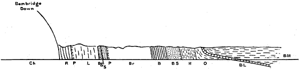
COAST SECTION, WHITECLIFF BAY.
BMBembridge Marls. BBarton Clay. ChChalk.
BLBembridge Limestone. BrBracklesham Beds. PPebble Beds.
OOsborne Beds. BgBagshot Beds. SSandstone Band.
HHeadon Beds. LLondon Clay.
BSBarton Sand. RReading Beds.
Above the Chalk we come first to a thick red clay called Plastic clay. It is much slipped, and the slip is overgrown. The only fossils found in the Island are fragments of plants; larger plant remains on the mainland show a temperate climate. This clay was formerly worked at Newport for pottery. The clay is probably a freshwater deposit formed in fairly deep water. On the mainland we find on the border shallow water deposits called the Woolwich and Reading beds. (The clay is 150 to 160 ft. thick at Whitecliff Bay, less than 90 ft. at the Alum Bay.) We come next to a considerable thickness of dark clay with sand, at the surface turned brown by weathering. This is the London clay, so called because it underlies the area on which London is built. At the base is a band of rounded flint pebbles, which extends at the base of the clay from here to Suffolk. In it, as well as in a hard sandstone 18 inches higher up, are tubular shells of a marine worm, Ditrupa plana. The sandstone runs out on the shore. About 35 ft. above the basement bed is a zone of Panopæa intermedia and Pholadomya margaritacea, at 50 ft. another band of Ditrupa, and at about 80 ft. a band with a small Cardita. In the higher part of the clay are large septaria,—rounded blocks of a calcareous clay-ironstone, with cracks running through them filled with spar. Pinna affinis is found in the septaria. The thickness of the clay in Whitecliff Bay is 322 feet. It can be seen on the shore, when the tide happens to have swept the sand away. Otherwise the lower beds are hardly visible, there being no cliff here, but a slope overgrown with vegetation.
In Alum Bay the London clay, about 400 ft. in thickness, consists of clays, chiefly dark blue, with sands, and lines of septaria. In the lower part is a dark clay with Pholadomya margaritacea, still preserving the pearly nacre. There are also Panopæa intermedia, and in septaria Pinna affinis. All these with their pearly lustre, are beautiful fossils. A little higher is a zone with Ditrupa, and further on a band of Cardita. Other shells also are found in the clay, especially in the lower part. They are all marine, and indicate a sub-tropical climate. Lines of pebbles show that we are near a beach. In other parts of the south of England remains from the land are found, borne down an ancient river in the way we found before in the Wealden deposits.
But times have changed since the Wealden days, and the life of the Tertiary times has a much more modern appearance. From leaves and fruits borne down from the forest we can learn clearly the nature of the early Eocene land and climate. Leaves are found at Newhaven, and numerous fossil fruits at Sheppey. The character of the vegetation most resembled that now to be seen in India, South Eastern Asia, and Australia. Palms grew luxuriantly, the most abundant fruit being that of one called Nipadites, from its resemblance to the Nipa palm, which grows on the banks of rivers in India and the Philippines. The forests also included plants allied to cypresses, banksia, maples, poplars, mimosa, custard apples, gourds, and melons. The rivers abounded in turtle—large numbers of remains of which are found in the London clay at the mouth of the Thames—crocodiles and alligators. With the exception of the south east of England, all the British Isles formed part of a continental mass of land covered with a tropical vegetation. The mountain chains of England, Scotland, and Wales rose as now, but higher. Long denudation has worn them down since. In the south-east of England the coast line fluctuated; and sea shells, and the remains of the plant and animal life of the neighbourhood of a great tropical river alternate in the deposits.
Fig. 4

SECTION THROUGH HEADON HILL AND HIGH DOWN. SHOWING STRATA SEEN AT ALUM BAY.
GGravel Cap. LHLower Headon. LLondon Clay.
BmBembridge Limestone. BSBarton Sand. RReading Beds.
OOsborne Beds. BBarton Clay. ChChalk.
UHUpper Headon. BrBracklesham Beds.
MHMiddle " BgBagshot Sands.
The London clay is succeeded by a great thickness of sands and clays which form the Bagshot series. These are divided in the London basin into Lower, Middle, and Upper Bagshot. In the Hampshire basin the strata are now classified as Bagshot Sands, Bracklesham Beds, Barton Beds, the last comprising the Barton Clay and the Barton Sand, formerly termed Headon Hill Sands. There is some uncertainty as to the manner in which these correspond to the beds of the Bagshot district, as the Tertiary strata have been divided by denudation into two groups, and differ in character in the two areas. It is possible that the Barton Sand represents a later deposit than any in the London area.
Almost the only fossil remains in the Bagshot Sands are those of plants, but these are of great interest. In Whitecliff Bay the beds consist for the most part of yellow sands, above which is a band of flint pebbles, which has been taken as the base of the Bracklesham series, for in the clay immediately above marine shells occur. The Bagshot Sands, in Whitecliff Bay, are about 138 feet thick, in Alum Bay, 76 feet, according to the latest classification. In Alum Bay the strata consist of sands, yellow, grey, white, and crimson, with clays, and bands of pipe clay. This is remarkably white and pure, as though derived from white felspar, like the China clay in Cornwall. The pipe clay contains leaves of trees, sometimes beautifully preserved. Specimens are not very easy to obtain, as only the edges of the leaves appear at the surface of the cliff. They have been found chiefly in a pocket, or thickening of the seam of pipe clay, which for forty years yielded specimens abundantly, afterwards thinning out, when the leaves became rare. The leaves lie flat, as they drifted and settled down in a pool. With them are the twigs of a conifer, occasionally a fruit or flower, or the wing case of a beetle. The leaves show a tropical climate. The flora is a local one, differing considerably from those of Eocene deposits elsewhere. The plants are nearly all dicotyledons. Of palms there are only a few fragments, while the London clay of Sheppey is rich in palm fruits, and many large palms are found in the Bournemouth leaf beds, corresponding in date to the Bracklesham. The differences may be largely due to conditions of locality and deposition. The Alum Bay flora is characterised by a wealth of leguminous plants, and large leaves of species of fig (Ficus); simple laurel and willow-like leaves are common, of which it is difficult to determine the species, and there is abundance of a species of Aralia. The character of the flora resembles most those of Central America and the Malay Archipelago.
PL. IV
Turritella Imbricataria Nummulites Lævigatus Limnæa Longiscata

Cardita Planicosta
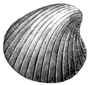
(Fusus) Leiostama Pyrus Cyrena Semistriata Planorbis Euomphalus
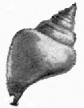
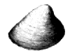
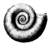
EOCENE AND OLIGOCENE
The Bracklesham Beds in Alum Bay (570 ft. thick) consist of clays, with lignite forming bands 6 in. to 2 ft. thick; white, yellow, and crimson sands; and in the upper part dark sandy clays, with bands showing impressions of marine fossils. Alum Bay takes its name from the alum formerly manufactured from the Tertiary clays. The coloured sands have made the bay famous. The colours of the sands when freshly exposed, and of the cliffs when wet with rain, are very rich and beautiful,—deep purple, crimson, yellow, white, and grey. Some of the beds are finely striped in different shades by current bedding. The contrast of these coloured cliffs with the White Chalk, weathered to a soft grey, of the other half of the bay is very striking and beautiful. About 45 ft. from the top is a conglomerate of flint pebbles, some of large size, cemented by iron oxide. In Whitecliff Bay the Bracklesham Beds (585 ft.) consist of clays, sands, and sandy clays, mostly dark, greenish and blue in colour, containing marine fossils and lignite. Sir Richard Worsley, in his History of the Isle of Wight, tells that in February, 1773, a bed of coal was laid bare in Whitecliff Bay, causing great excitement in the neighbourhood. People flocked to the shore for coal, but it proved worthless as fuel. It has, however, been worked to some extent in later years. In some of the beds are many fossils. Numbers have lately been visible where a large founder has taken place. There are large shells of Cardita planicosta and Turritella imbricataria. They are, however, very fragile. In a stratum just above these are numbers of a large Nummulite (Nummulites lævigatus). These are round flat shells like coins,—hence the name (Lat. nummus, a coin). They are a large species of foraminifera. We may split them with a penknife; and then we see a pretty spiral of tiny chambers. A smaller variety, N. variolarius, occurs a little further on, and a tiny kind, N. elegans, in the Barton clay. One of the most striking features of the later Eocene is the immense development of Nummulite limestones—vast beds built up of the delicate chambered shells of Nummulites,—which extend from the Alps and Carpathians into Thibet, and from Morocco, Algeria, and Egypt, through Afghanistan and the Himalaya to China. The pyramids of Egypt are built of this limestone.
The Bracklesham beds are followed by the Barton clay, famous for the number of beautiful fossil shells found at Barton on the Hampshire coast. At Whitecliff Bay the fossils are, unfortunately, very friable. At Alum Bay the pathway to the shore is in a gully in the upper part of the Barton clay. The strata consist of clays, sands, and sandy clays. The base of the beds is marked by the zone of Nummulites elegans. Numerous very pretty shells of the smaller Barton types may be found, with fragments of larger ones; or a whole one may be found. Owing to the cliff section cutting straight across the strata, which are nearly vertical, there is far less of the beds open to observation than at Barton, which probably accounts for the list of fossils being much smaller. The shells are chiefly several species of Pleurotoma, Rostellaria, Fusus, Voluta, Turritella, Natica, a small bivalve Corbula pisum, a tubular shell of a sand-boring mollusc Dentalium, Ostrœa, Pecten, Cardium, Crassatella. The fauna is like a blending of Malayan and New Zealand forms of marine life. Throughout the Eocene from the London clay onward the shells are such as abound in the warm sea south east of Asia. Similarly the plant remains take us into a tropic land, where fan palms and feather palms overshadowed the country, trees of the tropics mingling with trees we still find in more Northern latitudes. The general character of the flora as of the shells was Oriental and Malayan; both being succeeded in later strata by a flora and fauna with greater analogy to that now existing in Western North America.
In Alum Bay the Barton clay is suddenly succeeded by the very fine yellow and white sands which run along the western base of Headon Hill, the curve of the syncline bringing them round from a nearly vertical to an almost horizontal position. These are now known as the Barton Sand. They are 90 ft. thick, the whole of the Barton beds being 338 ft. in Alum Bay, 368 ft. in Whitecliff. The sands were formerly extensively used for glass making. They are almost unfossiliferous. The passage from Barton clay to the sands in Whitecliff Bay is more gradual. The sands here show some fine colouring which reminds us of the more celebrated sands of Alum Bay.
Chapter IX
THE OLIGOCENE
We pass on to strata which used to be called Upper Eocene, but are now generally classified as a period by themselves, and called the Oligocene. They are also known as the Fluvio-marine series. Large part was deposited in freshwater by rivers running into lagoons, or in the brackish water of estuaries, while at times the sea encroached, and beds of marine origin were laid down.
The west of the Island is much the best locality for the lower strata, those which take their name from Headon Hill between Alum and Totland Bays. There are three divisions of the Headon strata, marine beds in the middle coming between upper and lower beds formed in fresh and brackish water. Light green clays are very characteristic of these beds, and at the west of the Island thick freshwater limestones, which have died out before the strata re-appear in Whitecliff Bay. The strongest masses of limestone in Headon Hill belong to the Upper division. The limestones are full of freshwater shells, nearly all the long spiral Limnæa and the flat spiral disc of Planorbis, perhaps the most abundant species being L. longiscata and P. euomphalus. The limestones themselves are almost entirely the produce of a freshwater plant Chara, which precipitates lime on its tissues, in the same manner as the sea weeds we call corallines. On the shore round the base of Headon Hill lie numerous blocks of limestone, the débris of strata fallen in confusion, in which are beautiful specimens of Limnæa and Planorbis. The shells, however, are very fragile. The marine beds of the Middle Headon are best seen in Colwell Bay, where a few yards north of How Ledge they descend to the beach, and a cliff is seen formed of a thick bed of oysters, Ostrea velata. The oysters occupy a hollow eroded in a sandy clay full of Cytherea incrassata, from which the bed is known as the "Venus" bed, the shell formerly being called Venus, later Cytherea, at present Meretrix. The marine beds contain many drifted freshwater shells as Limnæa and Cyrena. The How Ledge limestone forms the top of the Lower Headon. It is full of well-preserved Limnæa and Planorbis.
The Upper and Lower Headon are mainly fresh or brackish water deposits. The purely freshwater beds contain Limnæa, Planorbis, Paludina, Unio, and land-shells. In the brackish are found Potamomya, Cyrena, Cerithium (Potamides), Melania and Melanopsis. Paludina lenta is very abundant throughout the Oligocene. A large number of the marine shells of the Headon beds are species also found in the Barton clay. Cytherea, Voluta, Ancillaria, Pleurotoma, Natica are purely marine genera.
In White Cliff Bay the beds are mostly estuarine. Most of the fossils are found in two bands, one about 30 ft. above the base of the series, the other a stiff blue clay, about 90 feet higher, which seems to correspond with the "Venus Bed" of Colwell Bay. Many of the fossils are of Barton types.
The Headon beds are about 150 feet thick at Headon Hill, 212 ft. in Whitecliff Bay; and are followed by beds varying from about 80 to 110 ft. in thickness, known as the Osborne and St. Helens series. They consist mainly of marls variously coloured, with sandstone and limestone. In Headon Hill is a thick concretionary limestone, which almost disappears northward. The Oligocene strata often vary considerably within short distances. The Osborne beds are exposed along the low shore between Cowes and Ryde, and from Sea View to St. Helens. In Whitecliff Bay they are not well seen, occurring in overgrown slopes. They consist mostly of red and green clays. A band of cream-yellow limestone a foot thick is the most conspicuous feature. The fossils resemble those from the Headon beds, but are much less plentiful. The marls seem to have been mostly deposited in lagoons of brackish water, which at the present day are favourite places for turtles and alligators, and of these many remains are found in the Osborne beds. The beds are specially noted for the shoals of small fish, Diplomystus vectensis (Clupea), first observed by Mr. G. W. Colenutt, F.G.S., and prawns found in them, and also remains of plants. The beds that appear in the neighbourhood of Sea View and St. Helens are divided into Nettlestone Grits and St. Helen's Sands, the former containing a freestone 8 feet thick.
Above these beds lies the Bembridge limestone, which is so conspicuous in Whitecliff Bay, and forms Bembridge Ledge. On the north shore of the Island the strata rise slightly on the northern side of the syncline. There are also minor undulations in an east and west direction. The result is to bring up the Bembridge limestone at various points along the north shore, where it forms conspicuous ledges—Hamstead Ledge at the mouth of the Newtown river, ledges in Thorness Bay, and Gurnard Ledge. In Whitecliff Bay the limestone, about 25 feet thick, forms the conspicuous reef called Bembridge Ledge. The Bembridge limestone consists of two or more bands of limestone with intercalated clays. It is usually whiter than the Headon limestones, and the fossils occur as casts, the shells being sometimes replaced by calc-spar. The limestone has been much used as a building stone for centuries, not only in the Island, but for buildings on the mainland. The most famous quarries were those near Binstead, from which Quarr, the site of the great Abbey, now almost entirely disappeared, derives its name. From these quarries was obtained much of the stone for Winchester Cathedral and many other ancient buildings. In the old walls and buildings of Southampton the stone may be recognised at once by the casts of the Limnæae it contains. The quarries at Quarr were noted in more ways than one. In later times the remains of early mammalia,—Palæotherium, Anoplotherium, and others—have been found. The quarries are now abandoned and overgrown. The limestone may be seen inland at Brading, where it forms the ridge on which the Church stands.
The limestone is a freshwater formation, and the fossils are mostly freshwater shells, of the same type as the Headon, Limnæa and Planorbis the most common. There are also land shells, especially several species of Helix, the genus which includes the common snail,—H. globosa, very large,—and great species of Bulimus (Amphidromus) and Achatina (B. Ellipticus, A. costellata). These interesting shells were chiefly obtained in the limestone at Sconce near Yarmouth, a locality now inaccessible, being occupied by fortifications. The land shells have an affinity to species now found in Southern North America. The limestone also abounds in the so-called "seeds" of Chara. The reproductive organs,—the "seeds,"—of this curious water-plant, allied to the lower Algæ, are, like the rest of the plant, encased in carbonate of lime, and are very durable. Large numbers are found in the Oligocene strata. Under the microscope they are seen to be beautifully sculptured in various designs, with a delicate spiral running round them. Above the limestone lie the Bembridge marls, varying in thickness in different localities from 70 to 120 feet. North of Whitecliff Bay they stretch on to the Foreland. They are in the main a freshwater formation, but a few feet above the limestone is a marine band with oysters, Ostrea Vectensis. It runs out along the shore, where the oysters may be seen covering the surface. The Lower Marls consist chiefly of variously-coloured clays with many shells, chiefly Cyrena pulchra, semistriata, and obovata, Cerithium mutabile, and Melania muricata (acuta); and red and green marls, in which are few shells, but fragments of turtle occur. A little above the oyster bed is a band of hard-bluish septarian limestone. Sixty years ago Edward Forbes remarked on the resemblance of this band to the harder insect-bearing limestones of the Purbeck beds. In a limestone exactly resembling this, and similarly situated in the lower part of the marls in Gurnard and Thorness Bays, numerous insects were afterwards found,—beetles, flies, locusts, and dragonflies, and spiders. Leaves of plants, including palms, fig, and cinnamon, have also been found in this bed, showing that the climate was still sub-tropical. The upper Marls consist chiefly of grey clays with abundance of Melania turritissima (Potamaclis). The chief shells in the marls are Cyrena, Melania, Melanopsis and Paludina (Viviparus). They are often beautifully preserved; the species of Cyrena often retain their colour-markings.
Bembridge Foreland is formed by a thick bed of flint gravel resting on the marls, which are seen again in Priory Bay, where in winter they flow over the sea-wall in a semi-liquid condition. They lie above the limestone at Gurnard, Thorness, and Hamstead. West of Hamstead Ledge the whole of the beds crop out on the shore, where beautifully preserved fossils may be collected. Large pieces of drift wood occur, also seeds and fruit. Many fragments of turtle plates may be found. Large crystals of selenite (sulphate of lime) occur in the Marls.
Last of the Oligocene in the Isle of Wight are the Hamstead beds. These strata are peculiar to the Isle of Wight. The Bembridge beds also are not found on the mainland, except a small outlier at Creechbarrow Hill in Dorset. The Hamstead beds consist of some 250 feet of marls, in which many interesting fossils have been found. They cover a large area of the northern part of the Island, largely overlaid by gravels, and are only seen on the coast at Hamstead, where they form the greater part of the cliff, which reaches a height of 210 ft., the top being capped by gravel. In winter the clays become semi-liquid, in summer the surface may be largely slip and rainwash, baked hard by the sun. The lower part of the strata may be best seen on the shore. The strata consist of 225 ft. of freshwater, estuarine, and lagoon beds, with Unio, Cyrena, Cyclas, Paludina, Hydrobia, Melania, Planorbis, Cerithium (rare), and remains of turtles, crocodiles, and mammals, leaves and seeds of plants; and above these beds 31 feet of marine beds with Corbula, Cytherea, Ostrea callifera, Cuma, Voluta, Natica, Cerithium, and Melania.
Except for the convenience of dividing so large a mass of strata, it would not be necessary to divide these from the Bembridge beds, as no break in the character of the life of the period occurs at the junction. The basement bed of the Hamstead strata is known as the Black Band, 2 feet of clay, coloured black with vegetable matter, with Paludina lenta very numerous, Melanopsis carinata, Limnæa, Planorbis, a small Cyclas (C. Bristovii), seed vessels, and lumps of lignite. It rests on dark green marls with Paludina lenta and Melanopsis, and full of roots. This evidently marks an old land surface. About 65 feet higher is the White Band,—a white and green clay full of shells, mostly broken. There are bands of tabular ironstone containing Paludina lenta. Clay ironstone was formerly collected on the shore between Yarmouth and Hamstead and sent to Swansea to be smelted. The strata consist largely of mottled green and red clays, probably deposited in brackish lagoons. These yield few fossils except remains of turtle and crocodile and drifted plants. The blue clays are much more fossiliferous. Among other plants are leaves of palm and water-lily. The strata gradually become more marine upwards. The marine beds were called by Forbes the Corbula beds, from two small shells, C. pisum and C. vectensis, of which some of the clays are full. Remains of early mammalia are found in the Hamstead beds, the most frequent being a hog-like animal, of supposed aquatic habits, Hyopotamus, of which there are more than one species.
The fauna and flora of the Oligocene strata show that the climate was still sub-tropical, though somewhat cooling down from the Eocene. Palms grew in what is now the Isle of Wight. Alligators and crocodiles swam in the rivers. Turtle were abundant in river and lagoon. Specially interesting in the Eocene and Oligocene are the mammalian remains. They show us mammals in an early stage before they branched off into the various families as we know them to-day. The Palæotherium was an animal like the tapir, now an inhabitant of the warmer regions of Asia and America. Recent discoveries in Eocene strata in Egypt show stages of development between a tapir-like animal and the elephant with long trunk and tusks. There were in those days hog-like animals intermediate between the hogs and the hippopotami. There were ancestors of the horse with three toes on each foot. There were hornless ancestors of the deer and antelopes. Many of the early mammals showed characters now found in the marsupials, the order to which the Kangaroo and Opossum belong, members of which are found in rocks of the Secondary Era, and are the only representatives of the mammalia in that age. Some of the early Eocene mammalia are either marsupials, or closely related to them. In the Oligocene we find the mammalian life becoming more varied, and branching out into the various groups we know to-day; while the succeeding Miocene Period witnesses the culmination of the mammalia—mammals of every family abounding all over the earth's surface, in a profusion and variety not seen before—or since, outside the tropics.
Chapter X
BEFORE AND AFTER.—THE ICE AGE.
We have read the story written in the rocks of the Isle of Wight. What wonderful changes we have seen in the course of the long history! First we were taken back to the ancient Wealden river, and saw in imagination the great continent through which it flowed, and the strange creatures that lived in the old land. We saw the delta sink beneath the sea, and a great thickness of shallow water deposits laid down, enclosing remains of ammonites and other beautiful forms of life. Then long ages passed away, while in the waters of a deeper sea the great thickness of the chalk was built up, mainly by the accumulation of microscopic shells. In time the sea bed rose, and new land appeared, and another river bore down fruits to be buried with sea shells and remains of turtles and crocodiles in the mud deposited near its mouth to form the London clay. We followed the alternations of sea and land, and the changing life of Eocene and Oligocene times. We have heard of the early mammalia found in the quarries of Quarr, and have learnt from the leaf beds of Alum Bay that at that time the climate of this part of the world was tropical. Indeed, I think everything goes to prove that through the whole of the times we have been studying,—except perhaps the earliest Eocene, that of the Reading beds,—the climate was considerably warmer than it is at the present day. After all these changes do you not want to know what happened next? Well, at this point we come to a gap in the records of the rocks, not only in the Isle of Wight, but also in the British Isles. The British Isles, or even England and Wales alone, are almost, if not quite unique in the world in that, in their small extent, they contain specimens of nearly every formation from the most ancient times to the present day. In other parts of the world we may find regions many times this area, where we can only study the rocks of some one period. But just at this point in the story comes a period,—a very important one, too,—the Miocene—of which we have no remains in our Islands. We must hear a little of what happened before we come back to the Isle of Wight again in comparatively recent times.
But, first, perhaps, I had better tell,—just in outline,—something of the earlier history of the world, before any of our Isle of Wight rocks were made. For, if I do not, quite a wrong idea may be formed of the world's history. The time of the Wealden river has seemed to us very ancient. We cannot say how many hundreds of thousands, or rather millions of years have passed since that ancient Wealden age. And you may have thought that we had got back then very near the world's birthday, and were looking at some of the oldest rocks on the globe. But no. We are not near the beginning yet. Compared with the vast ages that went before, our Wealden period is almost modern. We cannot tell with any certainty the comparative time; but we may compare the thickness of strata formed to give us some sort of idea. Now to the first strata in which fossil remains of living things are found we have in all a thickness of strata some 12 times that of all the rocks we have been studying from Wealden to Oligocene, together with the later rocks, Miocene and Pliocene, not found in the Isle of Wight. And before that there is, perhaps, an equal thickness of sedimentary deposits; though the fossils they, no doubt, once contained have been destroyed by changes the rocks have undergone.
Now let me try to give you some idea of the world's history up to the point where we began in the Isle of Wight. If we could see back through the ages to the furthest past of geological history, we should see our world,—before any of the stratified rocks were laid down in the seas,—before the seas themselves were made,—a hot globe, molten at least at the surface. How do we know this? Because under the rocks of all the world's surface we find there is granite or some similar rock,—a rock which shows by its composition that it has crystallised from a molten condition. Moreover we have seen that the interior of the earth is intensely hot. And yet all along the earth must be radiating off heat into the cold depths of space, and cooling like any other hot body surrounded by space cooler than itself. And this has gone on for untold ages. Far enough back we must come to a time when the earth was red hot,—white hot. In imagination we see it cooling,—the molten mass solidifies into Igneous rock,—the clouds of steam in which the globe is wrapped condense in oceans upon the surface. The bands of crystalline rock that rise above the primeval seas are gradually worn down by rain and rivers and waves, and the first sedimentary deposits laid down in the waters. And in the waters and on the land life appeared for the first time,—we know not how.
A vast thickness of stratified rocks was formed, which are called Archæan ("ancient"). They represent a time, perhaps, as great as all that has followed. These rocks have undergone great changes since their formation. They have been pressed under masses of overlying strata, and have come into the neighbourhood of the heated interior of the earth; they have been burnt and baked and compressed and folded, and acted on by heated water and steam, and their whole structure altered by heat and chemical action. Limestones, e.g., have become marble, with a crystalline structure which has obliterated any fossils they may have once contained. Yet it is probable that, like nearly all later limestones, they are of organic origin. These Archæan rocks cover a large extent of country in Canada. We have some of them in our Islands, in the Hebrides, and north-west of Scotland and in Anglesey, and rising from beneath later rocks in the Malvern Hills and Charnwood Forest.[12]
The Archæan rocks are succeeded by the most ancient fossiliferous rocks, the great series called the Cambrian, because found, and first studied, in Wales. They consist of very hard rocks, and contain large quantities of slate. They are followed by another series called the Ordovician; and that by another the Silurian. These three great systems of rocks measure in all some 30,000 ft. of strata. They form the hills of Wales and the English Lake District. They contain large masses of volcanic rocks. We can see where were the necks of old volcanoes, and the sheets of lava which flowed from them. The volcanoes are worn down to their bases now; and the hills of Wales and the Lakes represent the remains of ancient mountain chains, which rose high like the Alps in days of old, long before Alps or Himalayas began to be made. These ancient rocks contain abundant remains of living things, chiefly mollusca, crustaceans, corals, and other marine organisms, showing that the waters of those ages abounded with life.
We must pass on. Next comes a period called the Devonian, or Old Red Sandstone, when the Old Red rocks of Devon and Scotland were laid down. These contain remains of many varieties of very remarkable fish. A long period of coral seas succeeded, when coral reefs flourished over what was to be England; and their remains formed the Carboniferous Limestone of Derbyshire and the Mendip Hills. A period followed of immense duration, when over pretty well the whole earth there seem to have been comparatively low lands covered with a luxuriant and very strange vegetation. The remains of these ancient forests have formed the coal measures, which tell of the most widespread and longest enduring growth of vegetation the world has seen. Strange as some of the plants were—gigantic horsetails and club-mosses growing into trees—many were exquisitely beautiful. There were no flowering plants, but the ferns, many of them tree ferns, were of as delicate beauty as those of the present day. Many of the ferns bore seeds, and were not reproduced by spores, such as we see on the fronds of our present ferns. That is a wonderful story of plant history, which has only been read in recent years.
After the long Carboniferous period came to an end followed periods in which great formations of red sandstone were made,—the Permian, and the New Red Sandstone or Trias. During much of this time the condition of the country seems to have resembled that of the Steppes of Central Asia, or even the great desert of Sahara—great dry sandy deserts—hills of bare rock with screes of broken fragments heaped up at their base,—salt inland lakes, depositing, as the effect of intense evaporation, the beds of rock salt we find in Cheshire or elsewhere, in the same manner as is taking place to-day in the Caspian Sea, in the salt lakes of the northern edge of the Sahara, and in the Great Salt Lake of Utah.
At the close of the period the land here sank beneath the sea—again a sea of coral islands like the South Pacific of to-day. There were many oscillations of level, or changes of currents; and bands of clay, when mud from the land was laid down, alternate with beds of limestone formed in the clearer coral seas. These strata form a period known as the Jurassic, from the large development of the rocks in the Jura mountains. In England the period includes the Liassic and Oolitic epochs. The Liassic strata stretch across England from Lyme Regis in Dorset to Whitby in Yorkshire. Most of the strata we are describing run across England from south-west to north-east. After they were laid down a movement of elevation, connected with the movement which raised the Alps in Europe, took place along the lines of the Welsh and Scotch mountains and the chain of Scandinavia, which raised the various strata, and left them dipping to the south-east. Worn down by denudation the edges are now exposed in lines running south-west to north-east, while the strata dip south-east under the edges of the more recent strata. The Lias is noted for its ammonites, and especially for its great marine reptiles, Ichthyosaurus and Plesiosaurus. The Oolitic Epoch follows—a long period during which the fine limestone, the Bath freestone, was made; the limestones of the Cotswolds, beds of clay known as the Oxford and Kimmeridge clays; and again coral reefs left the rock known as coral rag. In the later part of the period were formed the Portland and Purbeck beds, marine and freshwater limestones, which contain also an old land surface, which has left silicified trunks of trees and stems of cycads.
And now following on these came our Wealden strata, the beginning of the Cretaceous period. You see what ages and ages had gone before, and that when Wealden times came, far back as they are, the world's history was comparatively approaching modern times. We must remember that all these formations, of which we have given a rapid sketch, are of great thickness,—thousands of feet of rock,—and represent vast ages of time. See what we have got to from looking at the shells in the sea cliff! We have come to learn something of the world's old history. We have been carried back through ages that pass our imagination to the world's beginning, to the time of the molten globe, before ever it was cool enough to allow life—we know not how—to begin upon its surface. And Astronomy will take us back into an even more distant past, and show us a nebulous mist of vast extent stretching out into space like the nebulæ observed in the heavens to-day, before sun and planets and moons were yet formed. So we are carried into the infinite of time and space, and questions arise beyond the power of human mind to solve.
Now we have, I hope, a better idea of the position the strata we have been specially studying occupy in the geological history, and shall understand the relation the strata we may find elsewhere bear to those in the Isle of Wight and the neighbouring south of England.
After this sketch of what went before our Island story, we must see what followed at the end of the Oligocene period. We said that there are no strata in the British Isles representing the next period, the Miocene. But it was a period of great importance in the world's history. Great stratified deposits were laid down in France and Switzerland and elsewhere, and it was a great age of mountain building. The Alps and the Himalaya, largely composed of Cretaceous and Eocene rocks, were upheaved into great mountain ranges. It is probable that during much of the period the British Isles were dry land, and that great denudation of the land took place. But in the first part of the period at all events this part of the world must have been under water, and strata have been laid down, which have since been denuded away. For our soft Oligocene strata, if exposed to rain and river action during the long Miocene period and the time which followed, would surely have been entirely swept away. The Miocene was succeeded by the Pliocene, when the strata called the Crag, which cover the surface of Norfolk and Suffolk, were formed. They are marine deposits with sea shells, of which a considerable proportion of species still survive.
We have seen that through the ages we have been studying the climate was mostly warmer than at the present day. The climate of the Eocene was tropical. The Miocene was sub-tropical and becoming cooler. Palms become rarer in the Upper strata. Evergreens, which form three-fourths of the flora in the Lower Miocene, divide the flora with deciduous trees in the Upper. And through the Pliocene the climate, though still warmer than now, was steadily becoming cooler; till in the beginning of the next period, the Pleistocene, it had become considerably colder than that of the present day. And then followed a time which is known as the great Ice Age, or the Glacial Period,—a time which has left its traces all over this country, and, indeed all over Northern Europe and America, and even into southern lands. The cold increased, heavy snowfalls piled up snow on the mountains of Wales, the Lake District, and Scotland; and the snow remained, and did not melt, and more fell and pressed the lower snow into ice, which flowed down the valleys in glaciers, as in Switzerland to-day. Gradually all the vegetation of temperate lands disappeared, till only the dwarf Arctic birch and Arctic willows were to be seen. The sea shells of temperate climates were replaced by northern species. Animals of warm and temperate climates wandered south, and the Arctic fox, and the Norwegian lemming, and the musk ox which now lives in the far north of America took their place; and the mammoth, an extinct elephant fitted by a thick coat of hair and wool for living in cold countries, and a woolly-haired rhinoceros, and other animals of arctic regions occupied the land. When the cold was greatest, the glaciers met and formed an ice-sheet; and Scotland, northern England and the Midlands, Wales, and Ireland were buried in one vast sheet of ice as Greenland is to-day.
How do we know this? To tell how the story has been read would be to tell one of the most interesting stories of geology. Here we can only give the briefest sketch of this wonderful chapter of the world's history. But we must know a little of how the story has been made out. We have already seen that the changes in plant and animal life point to a change from a hot climate, through a temperate, at last to arctic cold. Again, over the greater part of Northern England the rocks of the various geological periods are buried under sheets of tough clay, called boulder clay, for it is studded with boulders large and small, like raisins in a plum pudding. No flowing water forms such a deposit, but it is found to be just like the mass of clay with stones under the great glaciers and ice sheets of arctic regions; and just such a boulder clay may be seen extending from the lower end of glaciers in Spitzbergen, when the glacier has temporarily retreated in a succession of warm summers. The stones in our boulder clay are polished and scratched in a way glaciers are known to polish and scratch the stones they carry along, and rub against the rocks and other stones. The rock over which the glacier moves is similarly scratched and polished, and just such scratching and polishing is found on the rocks in Wales and the Lake District. Again, we find rocks carried over hill and dale and right across valleys, it may be half across England. We can trace for great distances the lines of fragments of some peculiar rock, as the granite of Shap in Westmorland; and even rocks from Norway have been carried across the North Sea, and left in East Anglia. This will just give an idea how we know of this strange chapter in the history of our land. For, by this time it was our land—England—much as we know it to-day; though at times the whole stood higher above sea level, so that the beds of the Channel and the North Sea were dry land. But, apart from variation of level, the geography was in the main as now.
Fig. 9
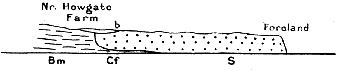
SHINGLE AT FORELAND.
BmBembridge Marls. bBrick Earth.
SShingle. CfOld Cliff in Marls.
Fig. 5
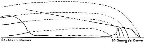
Dotted LinesFormer extension of Strata.
Broken LineFormer Bed of Valley sloping to St. George's Down.
The ice sheet did not come further south than the Thames valley. What was the country like south of this? Well, you must think of the land just outside the ice sheet in Greenland, or other arctic country. No doubt the winters must have been very severe,—hard frosts and heavy snows,—the ground frozen deep. Some arctic animals would manage to live as they do now just outside the ice sheet in Greenland. Now, have we any deposits formed at that time in the Isle of Wight? I think we have. A large part of the surface of the Island is covered by sheets of flint gravel. The gravels differ in age and mode of formation. We have already considered the angular gravels of the Chalk downs, composed of flints which have accumulated as the chalk which once contained them was dissolved away. But there are other gravel beds, which consist of flints which, after they were set free by the dissolution of the chalk, have been carried down to a lower level by rivers or other agency, and more or less rounded in the process. Many of these beds occur at a high level; and, as they usually cap flat-topped hills, they are known as Plateau Gravels. Perhaps the most remarkable is the immense sheet of gravel which covers the flat top of St. George's Down between Arreton and Newport. Gravel pits show upwards of 30 feet of gravel, consisting of flints with some chert and ironstone, and the greatest thickness is probably considerably more than this. The southern edge of the sheet is cut off straight like a wall. To the north it runs out on ridges between combes which have cut into it. In places in the mass of flints occur beds of sand, which have all the appearance of having been laid down by currents of water. The base of the gravel where it is seen on the steep southern slope of the down has been cemented by water containing iron into a solid conglomerate rock. The flints forming this gravel have not simply sunk down from chalk strata dissolved away; for they lie on the upturned edges of strata from Lower Greensand to Upper Chalk, which have been planed off, and worn into a surface sloping gently to the north; and over this surface the gravel has somehow flowed. The sharp wall in which it ends at the upper part of the slope shows that it once extended to the south over ground since worn away. Clearly, the gravel was formed before denudation had cut out the great gap between the central and southern downs of the Island. The down where the gravel lies is 363 ft. above sea level, 313 ft. above the bottom of the valley below. So that, though the gravel sheet is much newer than the strata we have been studying, it must nevertheless be of great antiquity.
It seems that at the top of St. George's Down we are standing on what was once the floor of an old valley. In the course of denudation the bottom of a river valley often becomes the highest part of a district. For the bed of the valley is covered by flint gravel, and flint is excessively hard, and the bed of flints protects the underlying rock; so that, while the rocks on each side are worn away, what was the river bed is eventually left high above them. Thus the highest points of a district are often capped by flint gravel marking the beds of old streams. Tracing up this old valley to the southward, at a few miles distance it will have reached the chalk region on the south of the anticline: and the flints carried down the valley may have come from beds of angular flints already dissolved out of the chalk such as we find on St. Boniface Down.
But how have these great masses of flints been swept along? Can the land have been down under the sea; and have sea waves washed the stones along? But these flints, though water-worn, are not rounded as we find beach shingle. What immense rush of water can have spread these flints 30 feet deep along a river valley? We must go to mountain regions for torrents of this character. And then, mountain torrents round the stones in their bed while these are mostly angular. The history of these gravels is a difficult one. I can only give what seems to me the most probable explanation. It appears to me probable that in the Ice Age, south of the ice sheet, the ground must have been both broken up by frosts, and also held together by being frozen hard to some depth. Then when thaws came in the short but warm summers, or when an intermission of the severe cold took place, great floods would flow down the valleys in the country south of the ice sheet, and masses of ice with frozen earth and stones would be borne along in a sort of semi-liquid flow. In this way Mr. Clement Reid explains the mass of broken-up chalk with large stones found on the heads of cliffs on the South coast, and known by the name of "combe-rock" or "head."
The Ice Age was not one simple period, and it is still difficult to fit together the history we read in different places, and in particular to correlate the gravels of the south of England with the boulder clays of the glaciated area. There were certainly breaks in the period, during which the climate became much milder, or even warm; and these were long enough for southern species of animals and plants to migrate northward, and occupy the lands where an arctic climate had prevailed. There were moreover considerable variations in the relative level of land and sea. So that we have a very complex history, which is gradually coming into clearer light.
That the gravels of the south of England belong largely to the age of ice, is shown by remains of the mammoth contained in many. These, however, are found in later gravels than those we have considered so far, gravels laid down after the land had been cut down to much lower levels. These lower gravels are known as Valley gravels, because they lie along the course of existing valleys, the Plateau gravels having been laid down before the present valleys came into existence. Teeth of the mammoth are found in the Thames valley, and on the shores of Southampton Water, in gravels about 50 to 70 feet above sea level, and have been found also in the Isle of Wight at Freshwater Gate, at the top of the cliffs near Brook, and in other places. The gravels near Brook with the clays on which they rest have been contorted, and the gravel forced into pockets in the clay, in a manner that suggests the action of grounding ice ploughing into the soil.
The high level gravels must belong to an early stage of the Glacial Epoch. We get some idea of the great length of time this age must have lasted, as we look from St. George's Down over the lower country of the centre of the Island. After the formation of the St. George's Down gravel the vast mass of strata between this and the opposite downs of St. Boniface and St. Catherine's was removed by denudation; and gravels were then laid down on the lower land, along Blake Down, at Arreton, over Hale common, and along the course of the Yar. Patches of gravel occur on the Sandown and Shanklin cliffs. At Little Stairs a gravel, largely of angular chert, reaches a thickness of 12 feet, and in parts are several feet of loam above gravel.
At the west of the Island a great sheet of gravel covers the top of Headon Hill, reaching a height of 390 feet. It appears sometimes to measure 30 feet in thickness. Like that on St. George's Down it slopes towards the Solent, resting on an eroded surface, in this case of Tertiary strata; and here too the upper part of the sheet has been removed by the wearing out of the deep valley between the Hill and the Freshwater Downs. The sheet lies on an old valley bottom, which sloped from the chalk downs on the south, then much higher and more extensive than now. Here too we may see something of the length of the Glacial Period. For at Freshwater Gate is a much later gravel, in which teeth of the mammoth have been found. It was probably derived from older gravels that once lay to the south, as the flints are rounded by transport. But the formation of all these gravels appears to belong to the Glacial Period; and as we stand in Freshwater Gate, and look at this great gap in the downs worn out by the Western Yar, and think of the time when a river valley passed over the tops of the High Downs and Headon Hill, we receive a strong impression of the length of the great Ice Age.
Now surely the question will be asked, what caused these changes of climate in the world's past history—so that at times a tropical vegetation spread over this land, and vegetation flourished sufficient to leave beds of coal within the Arctic circle, and in the Antarctic continent, and at another the climate of Greenland came down to England, and an ice sheet covered nearly the whole country? This still remains one of the difficult problems of Geology. An explanation has been attempted by Astronomical Theory, according to which the varying eccentricity of the earth's orbit—that is to say a slight change in the elliptic orbit of the Earth, by which at times it becomes less nearly circular—a change which is known to take place—may have had the effect of producing these variations of climatic conditions. The theory is very alluring, for if this be the cause, we can calculate mathematically the date and duration of the Glacial Period. But, unfortunately, supposing the astronomical phenomena to have the effect required, the course of events given by the astronomical theory would be entirely different to that revealed by geological research. Geographical explanations have usually failed through being of too local a character to explain a phenomenon which affected the whole northern hemisphere, and the effects of which reached at least as far south as the Equator,[13] and are seen again in the southern hemisphere in Australia, New Zealand, and South America. It is now believed that great world-movements take place, due to the contraction by cooling of the Earth's interior, and the adjustment of the crust to the shrinkage.[14] Possibly some explanation might be found in these world-wide movements; but their effect seems to last through too long periods of time to suit our Ice Ages. Again, while the geographical distribution of animals and plants in the present and past seems to imply very great changes in the land masses and oceanic areas,[15] these changes appear to bear no relation to glacial epochs. The cause of the Ice Ages remains at present an unsolved problem. More than one Ice Age has occurred during the long geological history. The marks of such a period are found in Archæan rocks, in the Cambrian, when glaciers flowed down to the sea level in China and South Australia within a few degrees of the tropics, and above all in early Permian times. The Dwyka conglomerate of the Karroo formation of South Africa (deposits of Permo-Carboniferous age) show evidence of extensive glaciation; deposits of the same age in Northern and Central India, even within the tropics, a glacial series of great thickness in Australia, and deposits in Brazil, appear to show a glaciation greater than that of the recent glacial period. Yet these epochs formed only episodes in the great geological eras. On the whole the climate throughout geological time would seem to have been warmer than at the present day. It may, perhaps, be doubted whether the earth has yet recovered what we may call its normal temperature since the Glacial Epoch.
Note on Astronomical Theory.—If the Ice Age be due to the increased eccentricity of the Earth's orbit, the theory shows that a long duration of normal temperature will be followed by a group of Glacial Periods alternating between the northern and southern hemispheres, the time elapsing between the culmination of such a period in one hemisphere and in the other being about 10,500 years. While one hemisphere is in a glacial period, the other will be enjoying a specially mild,—a "genial" period. Now, according to the record of the rocks, the "genial" periods were far from being those breaks in the Glacial which we know as Inter-glacial periods. We have the immensely long warm period of the Eocene and Oligocene, the Miocene with a still warm but reduced temperature, and then the gradual cooling during the Pliocene, till the drop in temperature culminates in the Ice Age. Moreover, the duration of each glaciation during this Ice Age is usually considered to have been much longer than the 10,000 years or so given by the Astronomical Theory. Add to this that the periods of high eccentricity of the Earth's orbit, though occurring at irregular intervals, are, on the scale of geological time, pretty frequent; so that several of such periods would have occurred during the Eocene alone. Yet the geological evidence shows unbroken sub-tropical conditions in this part of the world throughout the Eocene.
Chapter XI
THE STORY OF THE ISLAND RIVERS; AND HOW THE ISLE OF WIGHT BECAME AN ISLAND
We must now consider the history of the river system of the Isle of Wight, to which our study of the gravels has brought us. For rivers have a history, sometimes a most interesting one, which carries us back far into the past. Even the little rivers of the Isle of Wight may be truly called ancient rivers. For though recent in comparison with the ages of geological time, they are of a vast antiquity compared with the historical periods of human history.
To understand our river systems we must go back to the time when strata formed by deposit of sediment in the sea were upheaved above the sea level. To take the simplest case, that of a single anticlinal axis fading off gradually at each end, we shall have a sort of turtle back of land emerged from the sea, as in figure 6, aa being the anticlinal axis. From this ridge streams will run down on either side in the direction of the dip, their course being determined by some minor folds of the strata, or difference of hardness in the surface, or cracks formed during elevation. On each side of the dip-streams smaller ones will flow, more or less in the direction of the strike, and run into the main streams. Various irregularities, such as started the flow of the streams, will favour one or another. Consider three streams, a, b, c, and let us suppose the middle one the strongest, with greatest flow of water, and cutting down its bed most rapidly. Its side streams will become steeper and have more erosive force, and so will eat back their courses most rapidly until they strike the line of the streams on either side. Their steeper channels will then offer the best way for the upper waters of the streams they have cut to reach the sea; and these streams will consequently be tapped, and their head waters cut off to flow to the channel of the centre stream. We shall thus have for a second stage in the history a system such as is shown in fig. 7. The same process will continue till one river has tapped several others; and there will result the usual figure of a river and its tributaries, to which we are accustomed on our maps. We shall observe that tributaries do not as a rule gradually approach the central stream, but suddenly turn off at nearly a right angle from the direction in which they are flowing, and, after a longer or shorter course, join at another sharp angle a river flowing more or less parallel to their original direction.
Fig. 6
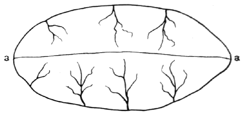
Fig. 7
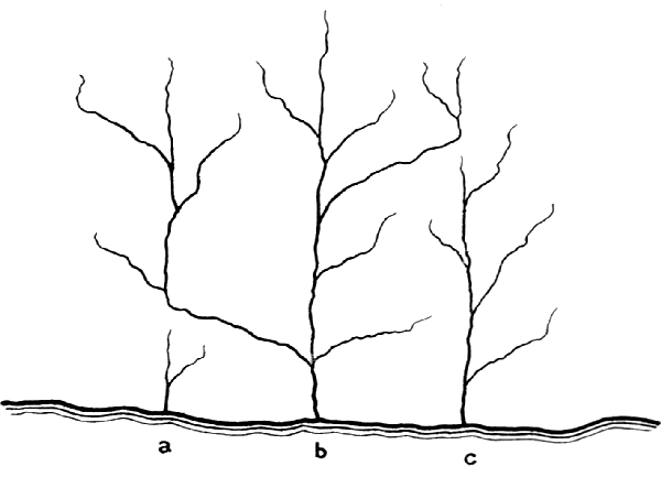
Development Of River Systems
The Chalk and overlying Tertiary strata were uplifted from the sea in great folds forming a series of such turtle-backs as we have been considering. The line of upheaval was not south-west and north-east, as that which raised the older formations in bands across England, but took place in an east and west direction. The main upheaval was that of the great Wealden anticline. Other folds produced the Sandown and Brook anticlines, and that of the Portsdown Hills. The upheaval seemed to have been caused by pressure acting from the south, for the steeper slope of each fold is on the northern side. Our latest Oligocene strata are tilted with the chalk, showing that the upheaval took place after Oligocene times. But the great movement was in the main earlier than the Pliocene. For on the North Downs near Lenham is a patch of Lower Pliocene deposit resting directly on the Chalk, the older Tertiary strata having been removed by denudation, clearly due to the uplift of the Wealden anticline. The raising of the Pliocene deposit to its present position proves that the same movement was continued at a later time, probably during the Pleistocene. But the greater part of the movement may be assigned to the Miocene, the period of great world-movements which raised the Alps and the Himalaya.
Many remarkable, and, at first sight, very puzzling features connected with the courses of rivers find an explanation when we study the river history. Thus, looking at the Weald of Kent and Sussex, we see that it consists of comparatively low ground rising to a line of heights east and west along the centre, and surrounded on all sides but the south-east by a wall of Chalk downs. If we considered the subject, we should suppose that the drainage of the country would be towards the south-east, which is open to the sea. Not so. All the rivers flow from the central heights north and south,—go straight for the walls of chalk downs, and cut through the escarpment in deep clefts to flow into the Thames and the Channel. This is explained when we remember that the rivers began to flow when the great curve of strata rose above the sea. Though eroded by the sea during its elevation, yet when it rose above the waters the arch of chalk must have been continuous from what are now North Downs to South. And from the centre line of the great turtle back the streams began to flow north and south, cutting in the course of ages deep channels for themselves. The greater erosion in their higher courses has cut away the mass of chalk from the centre of the Weald, but the rivers still flow in the direction determined when the arch was still entire.
We have a similar state of things in the Isle of Wight. Any one not knowing the geological story, and looking at the geography of the Island, might naturally suppose that there would be a stream flowing from west to east, through the low ground between the two ranges of downs, and finding its way into the sea in Sandown Bay. Instead of this the three rivers of the Island, the two Yars and the Medina, all flow north, and cut through the chalk escarpment of the Central downs, as if an earthquake had made rifts for them to pass, and so find their way into the Solent. The explanation is the same as in the case of the Weald. The rivers began to flow when the Chalk strata were continuous over the centre of the Island; and their course was determined when the east and west anticlinal axis rose above the sea.
We shall notice, however, that the Island rivers start from south of the anticlinal axis. The centre of the Sandown anticline runs just north of Sandown, but the various branches of the Yar and Medina flow from well south of this. The explanation would appear to be that the anticline is almost a monoclinal curve,—that is to say, one slope is steep, the other not far from horizontal. Streams starting from the ridge would flow with much greater force down the northern than the southern side, and would cut back their course much more quickly. Thus they would continually cut into the heads of the southern streams, and turn the water supplying them into their own channels.
In its early history a river cuts out its bed, and carries along pebbles, sand and mud to the sea. The head waters are constantly cutting back, and the slope becoming less steep, till a time comes when the stream in its gently inclined lower course has no more power to excavate, and the finer sediment, which is all that now reaches the lower river, begins to fill up the old channel. And so the alluvium is formed which fills the lower portions of our river valleys.
Beyond this, the great rush of waters from melting snows and ice of the Glacial Period has come to an end. The gentler and diminished streams of a drier age have no power to roll flint stones along and form beds of gravel. Gravel terraces border our river valleys at a higher level than the present streams. Periods alternated during which gravels were laid down by the river, and when the river acquiring more erosive force, by an elevation of the land giving its bed a steeper gradient, or a wetter climate producing a greater rush of water, cut a new channel deeper in the old valley. So our valleys in Southern England are frequently bordered by a succession of gravel terraces, the higher ones being the older, dating from times when the river flowed at a higher level than at present. Such terraces may be seen above the Eastern Yar and its tributary streams. In the centre of the old gravels is the alluvial flat of a later age.
The Island rivers cut out their channels when the land stood at a higher level than at present. The old channels of the lower parts of the rivers are now filled with alluvium, partly brought down by the rivers and partly marine. The channels are cut down considerably below sea level; and by the sinking of the land the sea has flowed in, and the last parts of the river courses are now tidal estuaries. The sea does not cut out estuaries. They are the submerged ends of river valleys.
Some idea may be formed of the antiquity of our Island rivers by observing the depth of the clefts they have cut through the downs at Brading, Newport, and Freshwater. But to this we must add the depth at which the old channels lie below the alluvium. It would be interesting to know the thickness of the alluvium. But it is not often that borings come to be made in river alluvia. However, in the old Spithead forts artesian wells are sunk; and these pass through 70 to 90 feet of recent deposits before entering Eocene strata. Under St. Helen's Fort, at the mouth of Brading Harbour, are 80 feet of recent deposits. The old channel of the Yar, at its mouth, must lie at least at this depth.
Before it passes through the gap in the Chalk downs the Yar has meandered about, and formed the alluvial flat called Morton marshes. These marshes stretch out into the flat known as Sandown Level, which occupies the shore of the bay between Sandown and the Granite Fort. What is the meaning of this extension of the alluvium away from the course of the river out to the sea at Sandown? A glance at it as pictured on a geological map will suggest the answer. We see clearly the alluvia of two streams converging from right and left, and uniting to pass to the sea through Brading Harbour. But the stream to the right has been cut off by the sea encroaching on Sandown Bay: only the last mile of alluvium is left to tell of a river passed away. We must reconstruct the past. We see the Bay covered by land sloping up to east and south east, the lines of downs extending eastward from Dunnose and the Culvers, and an old river flowing northward, and cutting through the chalk at Brading after being joined by a branch from the west. This old river must have been the main stream. For it was a transverse stream, flowing nearly at right angles to the ridge of the anticline; while the Yar comes in as a tributary in the direction of the strike. Of other tributary streams, all from the right are gone by the destruction of the old land. On the left streams would flow in from the combes at Shanklin and Luccombe—streams which have now cut out Shanklin and Luccombe chines.
Passing the gap in the downs the river meandered about, and, with marine deposit, washed in by the tides, formed the expanse of alluvium which occupies what was Brading Harbour,—a harbour which in old times presented at high tide a beautiful spectacle of land-locked water extending up to Brading. Inclosures and drainings have been made from time to time, the upper part near Yarbridge being taken in in the time of Edward I. Further innings were made in the reign of Queen Elizabeth; and Sir Hugh Middleton, who brought the New River to London, made an attempt to enclose the whole, but the sea broke through his embankment. The harbour was finally reclaimed at great cost in 1880, the present embankment enclosing an area of 600 acres.
The history of the Western Yar is similar to that of the Eastern. The main stream must have flowed from land now destroyed by the sea stretching far south of Freshwater Gate. All that is left is its tidal estuary, and the gravel terraces and alluvial flat formed in the last part of its course. Of a tributary stream an interesting relic remains. For more than 2 miles from Chilton Chine through Brook to Compton Grange a bed of river gravel lies at the top of the cliff, marking the course of an old stream, of which coast erosion has made a longitudinal section. This was a tributary of the Yar, when the mammoth left his remains in the gravel at Grange Chine and Freshwater Gate. Down the centre of the gravels lies a strip of alluvium laid down by a stream following the same course in later days. The sea had probably by this time cut into the stream; and it most likely flowed into the sea somewhere west of Brook. In the alluvium hazel nuts and twigs of trees are found at Shippard's Chine near Brook.
The lower course of the Medina is a submerged river valley, the tide flowing up to Newport. The river rises near Chale, and flows through a strip of alluvium, overgrown with marsh vegetation, known as "The Wilderness." This upper course of the Medina, from the absence of gravels or brick earth, has the appearance of a comparatively modern river. But the Medina has a further history. If you look at the map you will see branches of the Yar running south to north as transverse streams, but the main course is that of a lateral river. Look at the two chief sources of the Yar—the stream from near Whitwell and Niton, and that from the Wroxall valley. When they get down to the marshes near Rookley and Merston, they are not flowing at all in the direction of Sandown or Brading. They rather look as if they would flow along the marshy flat by Blackwater into the Medina. But the Yar cuts right across their course, and carries them off eastward to Sandown. When we look, we find a line of river valley with a strip of alluvium running up from the Medina at Blackwater in the direction of these two streams—a valley which the railway up the Yar valley from Sandown makes use of to get to Newport. There can be little doubt that these streams from Niton and Wroxall originally ran along this line into the Medina; but the Yar, cutting its course backward, has captured them, and diverted their course. They probably represent the main branches of the Medina in earlier times, the direction of flow from south-east to north-west instead of south to north being possibly due to the overlapping in the neighbourhood of Newport of the ends of the Brook and Sandown anticlines. The sheet of gravel on Blake Down belongs to this period of the river's history. The river must have diverted between the deposition of the Plateau Gravels and that of the Valley Gravels of the Yar. For the former follow the original valley, the latter the new course of the river.
We must now take a wider outlook, and see what became of our rivers after they had flowed across what is now the Isle of Wight from south to north. We have been speaking of times when the Island was of much greater extent than at present. Standing on the down above the Needles, and looking westward, we see on a clear day the Isle of Purbeck lying opposite, and we can see that the headland there is formed by white chalk cliffs like those beneath us. In front of them stand the Old Harry Rocks, answering to the Needles, both relics of a former extension of the land. In fact Purbeck is just like a continuation of the Isle of Wight. South of the Chalk lie Greensand and Wealden strata in Swanage Bay, and north towards Poole are Tertiaries. Clearly these strata were once continuous with those of the Isle of Wight. We must imagine the chalk downs of the Island continued as a long range across what is now sea, and on through Purbeck. A great Valley must have stretched from west to east, north of this line, along the course of the Frome, which runs through Dorset, and now enters the sea at Poole Harbour, on by Bournemouth, and along the present Solent Channel—a valley still much above sea level, not yet cut down by rivers and the sea—and down the centre of this valley a river must have flowed, which may be called the River Solent. It received as tributaries from the south the rivers of the Isle of Wight, and others from land since destroyed by the sea. There flowed into it from the north the waters of the Stour and Avon, and an old river which flowed down the line of what is now Southampton Water. Southampton Water looks like the valley of a large river, much larger than the present Test and Itchen. Its direction points to a river from the north west; and it has been shown by Mr. Clement Reid that the Salisbury rivers—Avon, Nadder, and Wily—at a former time, when they flowed far above their present level—continued their course into the valley of Southampton Water. For fragments of Purbeck rocks from the Vale of Wardour, west of Salisbury, have been found by him in gravels on high land near Bramshaw, carried right over the deep vale of the Avon in the direction of the Water. The lower Avon would originally be a tributary of the Solent River; and it enters the sea about mid-way between the Needles and the chalk cliffs of Purbeck, just opposite the point where we might suppose the sea would have first broken through the line of chalk downs. No doubt it broke through a gap made by the course of an old river from the south, as it is now breaking through the gap made by the old Yar at Freshwater. When the river Solent had been tapped at this point, the Avon just opposite would have acquired a much steeper flow, causing it to cut back at a faster rate, till it cut the course of the old river which ran by Salisbury to Southampton, and, having a steeper fall, diverted the upper waters of this river into its own channel.
Fig 8
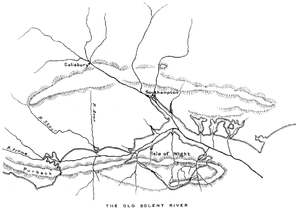
Frost and rain and rivers cut down the valleys of the river system for hundreds of feet; the sea which had broken through the chalk range gradually cut away the south side of the main river valley from Purbeck to the Needles; and eventually the valley itself was submerged by a subsidence of the land, and the sea flowed between the Isle of Wight and the mainland.
A gravel of somewhat different character to the rest is the sheet of flint shingle at Bembridge Foreland. It forms a cliff of gravel about 25 feet high resting on Bembridge marls, and consists of large flints, with lines of smaller flints and sand showing current bedding, and also contains Greensand chert and sandstone, which must have been brought from some district beyond the Chalk. The shingle slopes to north-east. To the south-west it ends abruptly, the dividing line between shingle and marls running up steeply into the cliff. This evidently marks an old sea cliff in the marls, against which the gravel has been laid down.[16]
One or two comparatively recent deposits may be mentioned here. At the top of the cliff in Totland Bay, about 60 ft. above the sea, for a distance of 350 yards, is a lacustrine deposit, consisting in the main of a calcareous tufa deposited by springs flowing from the limestone of Headon Hill. The tufa contains black lines from vegetable matter, and numerous land and freshwater shells of present-day species—many species of Helix, especially H. nemoralis and H. rotundata, Cyclostoma elegans, Limnæa palustris, Pupa, Clausilia, Cyclas, and others.
On the top of Gore Cliff is a deposit of hard calcareous mud, reaching a thickness of about 9 feet, and forming a small vertical cliff above the slopes of chalk marl. It extends north a few yards beyond the chalk marl on to Lower Greensand. It has been formed by rainwash from a hill of chalk, which must once have existed to the south. The deposit contains numerous existing land-shells, especially Helix nemoralis and other species of Helix.
Between Atherfield and Chale at the top of the cliff is a large area of Blown Sand. The sand is blown up from the face of the cliff below. It reaches a thickness of 20 feet, and possibly more in places, and forms a line of sand dunes along the edge of the cliff. The upper part of Ladder Chine shows an interesting example of wind-erosion. The sand driven round it by the wind has worn it into a semi-circular hollow like a Roman theatre.
Small spits, consisting partly of blown sand, extend opposite the mouths of the Western Yar, the Newtown river, and the most extensive—at the mouth of the old Brading Harbour, separating the present reduced Bembridge Harbour from the sea. This is called St. Helen's Spit, or "Dover,"—the local name for these sand spits.
Chapter XII
THE COMING OF MAN.
We have watched the long succession of varied life on the earth recorded in the rocks, and now we come to the most momentous event of all in the history—the coming of Man. The first certain evidence of the presence of man on the earth is found with the coming of the Glacial Period,—unless indeed the supposed flint implements found by Mr. Reid Moir, under the Crag in Suffolk, should prove him earlier still. It is a rare chance that the skeleton of a land animal is preserved; especially rare in the case of a skeleton so frail as that of man. The best chance for the preservation of bones is in deposits in caves, which were frequently the dens of wild beasts and the shelters of man. But the implements used by early man were happily of a very imperishable nature. His favourite material, if he could get it, was flint. Flint could by dexterous blows have flake after flake taken off, till it formed a tool or weapon with sharp point and cutting edge. The implements, though only chipped, or flaked, were often admirably made. They have very characteristic shapes. Moreover, the kind of blow—struck obliquely—by which these early men made their tools left marks which stamp them as of human workmanship. The flake struck off shows what is called a "bulb of percussion"—a swelling which marks the spot where the blow was struck—and from this extends a series of ripples, producing a surface like that of a shell, from which this mode of breaking is called conchoidal fracture. Often, by further chipping the flake itself is worked into an implement. Implements have also been made of chert, but it is far more difficult to work, as it naturally breaks in an irregular way into sharp angular fragments. Flint, on the other hand, lent itself admirably to the use of early man, who in time acquired a perfect mastery of the material. The working of flints is so characteristic that, once accustomed to them, you cannot mistake a good specimen. Sea waves dashing pebbles about will sometimes produce a conchoidal fracture, but never a series of fractures in the methodical way in which a flint was worked by man. And, of course, specimens may be found so worn that it is difficult to be sure about their nature. Again early man may, especially in very early times, have been content to use a sharp stone almost as he found it, with only the slightest amount of knocking it into shape. So that in such a case it will be very difficult to decide whether the stones have formed the implements of man or not. In later times men learnt to polish their implements, and made polished stone axes like those the New Zealanders and South Sea Islanders used to make in modern times. The old age of chipped or flaked implements is called the Palæolithic; the later age when they were ground or polished the Neolithic. (Simple implements, as knives and scrapers, were still unpolished.) The history of early man is a long story in itself, and of intense interest. But we must not leave our geological story unfinished by leaving out the culmination of it all in man. In the higher gravels—the Plateau Gravels—no remains of man are found; but in the lower—the Valley Gravels,—of the South of England is found abundant evidence of the presence of man. Large numbers of flint implements have been collected from the Thames valley and over the whole area of the rivers which have gravel terraces along their course. Over a large sheet of gravel at Southampton, whenever a large gravel pit is dug, implements are found at the base of the gravel.[17] The occurrence of the mammoth and other arctic creatures in the gravels shows that in the Glacial Period man was contemporary with these animals. Remains in caves tell the same story. In limestone caverns in Devon, Derbyshire, and Yorkshire, implements made by man are found in company with remains of the cave bear, cave hyæna, lion, hippopotamus, rhinoceros, and other animals either extinct or no longer inhabitants of this country—remains which have been preserved under floors of stalagmite deposited in the caves. In caves of central France men have left carvings on bone and ivory, representing the wild animals of that day—carvings which show a remarkable artistic sense, and a keen observation of animal life. Among them is a drawing of the mammoth on a piece of mammoth ivory, showing admirably the appearance of the animal, with his long hair, as he has been found preserved in ice to the present day near the mouths of Siberian rivers. Drawings of the reindeer, true to life, are frequent.