THE CLIFF RUINS (continued 2)
Reading edition
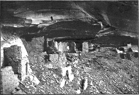
Plate XLIX. Eastern Cove of Mummy Cave
The house remains in the eastern cove are partly shown in plate XLIX, which is from a photograph. The point of view is from the ledge in front of the tower. The ruins rest on a ledge in the back of the cove formed of debris well compacted and apparently consisting partly of sheep dung. The rooms are small, sometimes three deep against the back of the cove, and many of them could only have been used for storage. The principal structure is the western kiva, with its chimney-like attachments. This is described at length on pages 177, 179, 186, and 187. Adjoining it on the east is another kiva, part of whose wall is still two stories high, and clearly shown in the illustration. Some 50 or 60 feet to the east or southeast there is another circular structure, which apparently had no interior bench. The small semicircular structure shown on the plan and in the illustration, which rests against and is roofed by the rock, is a Navaho burial cist, and
Many of the walls are built entirely of small pieces of stone, not more than 3 or 4 inches long by 2 inches wide and half an inch to an inch and a half thick. This construction is especially noticeable in inner walls. The joints are carefully plastered, evidently with the hand, but the mud is seldom allowed to cover the stone. It appears to have been applied externally, in pellets about the size of a walnut. The general thickness of walls is about 15 inches, although on the intermediate ledge they are over 2 feet, but some of the less important walls consist of a single layer, 6 to 8 inches thick. Walls are sometimes seen here supported by vertical timbers incorporated in them after the manner later described at some length. Ends of logs project here and there from the debris on the slope, but probably many of them are the débris of roofs.
The peculiar and anomalous features presented by the remains on the intermediate ledge seem to require some explanation. This portion of the ruin is not only different from the other portions, but different also from anything else in the canyon, and the difference is not one of degree only. Doubtless systematic excavation in the various parts of the ruin would afford an explanation. In the absence of such work we can only speculate on the problem.
The occurrence of two chimney-like shafts in connection with the rectangular rooms west of the tower is significant. Nowhere else in the canyons, except in the Casa Blanca ruin, do these structures occur, so far as known, except in connection with circular kivas. As regards the ruin named, it is almost certain that it was occupied in the historic period, probably in the seventeenth century.
The division of the ruin into three separate parts, the absence of kivas in the western cove, and the method of access to that portion all attract attention. If there were monks or other Spaniards in the settlement, the explanation would be plain; they and those of the natives allied with them would occupy the central ledge, and the anomalous features would be natural under the circumstances. Such a hypothesis would explain also the source of the many unaboriginal features which are found in other parts of the canyon, but there is no direct evidence to support it. It should be mentioned, however, that the walls here rest on about half an inch of substance which resembles compacted sheep dung. If the substance is really such, the walls must have been built within the historic period.
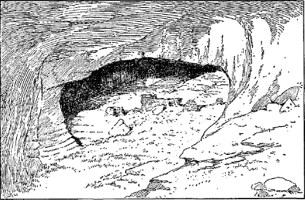
Fig. 17—Ruin in a rock cove.
At the point marked 48 on the map there is a ruin which resembles somewhat in its location an example previously described (page 98). It is situated in a cove in a jutting point of rock, forming part of the talus slope, and is about 20 feet above the bottom, which it overlooks. Figure 17 shows the character of the site, and figure 18 is a spawls.
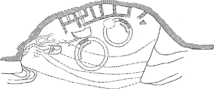
Fig. 18—Ground plan of a ruin in a rock cove.
Some of the walls were plastered. The western end of the ruin has been partially restored by the Navaho and used for burial cists, and other cists have been built on the site independent of the old walls, as shown on the plan. Figure 19 is a ground plan of a ruin on a 15 on the map. It is situated at the back of a considerable bay, directly opposite a large rock at the mouth of Del Muerto, and overlooked the whole of the bottom land in the bay. The houses were built on a bench or ledge, about 30 feet wide, overhung by the cliff above and dropping down almost vertically to the bottom land, about 40 feet below, but on the east access to the bench was easy by a slope of talus extending up to it. The site was covered with bowlders, and walls have been built over and under them. The masonry is good, and was composed of larger stones than usual, carefully chinked with spalls, the work being well done.
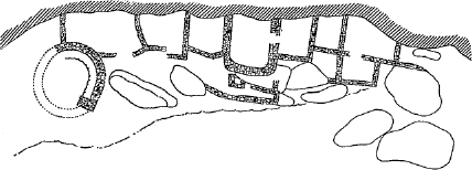
Fig. 19—Ground plan of a ruin on a ledge.
There were but 10 rooms on the ground, in addition to one circular kiva; some of these rooms are too small for habitation, and one of them appears to have been a rectangular kiva. On the same bench, about 100 feet westward, however, there are traces of other rooms, the walls of which were very thin. The cliffs back of the ruin and for 200 feet west of it are covered with pictographs in white and colors.
Near the center of that portion of the ruin shown on the ground plan there is a large room which may have been a rectangular kiva. The walls are over 2 feet thick in the first story, diminishing at the roof level by a step or setback to the ordinary thickness of about a foot. These walls, as usual in such structures, were about 2 feet thick; they are slightly curved, the front wall markedly so, and the interior corners are well rounded. No reason for this curvature is apparent, and it is certainly not dictated by the occurrence of the rock over which the wall is built, as only the point of this rock comes through the wall in the western side of the front wall. There may have been an opening into the room through the eastern wall connecting it with the room on that side, as the masonry is there broken down; but this is doubtful, as the eastern room itself has no exterior opening. It is more probable that the large room was entered through the roof, for the thin wall of the second story shows in front one side of a well-finished doorway.
Just outside of the heavy front wall there is a round hole in the ground, the remains of a vertical shaft connected with the interior of the room. The hole is about a foot in diameter, and is neatly plastered
The circular kiva occupies the western end of that part of the room shown in the plan. It was 15 feet in diameter, and is exceptionally well built. The wall is standing for about half of its circumference, and was so neatly finished that the interior coating of plaster was apparently omitted. There are no traces of inclosing rectangular walls; the thickness of the kiva walls and the exceptionally large stones used in parts of it suggest that the kiva stood alone. So far as the walls remain standing, an interior bench can be traced, about 2 feet wide and 6 feet below the top of the outside wall. On the southeastern side, in the interior, there is a buttress or projection, which terminates the bench at this point.
The walls between the rectangular room described and the circular kiva are thin and very irregularly laid out. In front of the rectangular room and on the edge of the bench, which is here but a few feet above the talus, a rather heavy wall has been built over the top of a rock, and inside or to the north of it another wall has been placed, hardly 2 feet distant. These walls are connected at the eastern end by a thin cross wall, now but slightly above the ground surface and notched like a doorway. Below the notch a slab of stone has been placed and was apparently used as a step. The purpose of these walls is not clear, but they may have constituted an entrance or passageway to the village. If so, we have here a very efficient defensive expedient and a decided anomaly in cliff-village architecture.
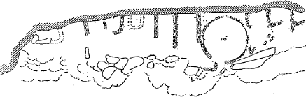
Fig. 20—Ground plan of ruin No. 31, Canyon de Chelly.
At the point marked 31 on the map there is a small ruin on a ledge about 150 feet above the bottom and difficult of access. The site overlooks considerable areas of bottom land on both sides of the canyon, and was probably connected with and formed part of a larger ruin on the same ledge and east of it, which will next be described. On this site there are remains of half a dozen rooms or more and of one circular kiva, which was 20 feet in diameter. (See ground plan, figure 20.) The site has been much filled up, and the kiva appears as a cylindrical depression, flush with the ground outside, but 3 to 5 feet deep inside. The walls are rather thin and smoothly plastered inside. On the south
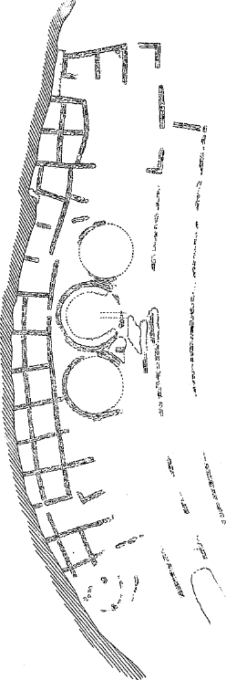
Fig. 21—Ground plan of ruin No. 32, Canyon de Chelly. Horizontal View
Immediately above the last-mentioned ruin, and on the same ledge, occur the remains of a large settlement, shown in plan in figure 21. It will be noticed that here, as in some of the previous examples described, the general arrangement consists of a row of rooms against the cliff, with the kivas in front. There were at least 17 rooms in line, and there may have been as many as 30 to 50 rectangular rooms in the village, scattered over an area nearly 200 feet long by 65 feet wide, but not all of this area was covered. Three kivas are still clearly shown.
This ruin is especially interesting on account of the site it occupies. The walls were placed on sharply sloping rock and in some cases on loose debris, and numerous expedients were resorted to to prevent them from slipping down the slope. The
The whole slope is more or less covered with debris, and there is no doubt that this was at one time a considerable settlement. The cliff walls near the east end show traces of two stories, and in one place of three stories, which formerly rested against them. Moreover, the number of successive coats of plaster in the kiva shows an extended occupancy, an inference which is further supported by the variety of expedients which were adopted to hold the walls in place.
The marked irregularity of the five eastern rooms as compared with the regular series west of them will be noticed on the plan. These eastern rooms must have been added at a period subsequent to the completion of the others. The marks of a second and third story occur on the cliff back of this cluster, and there is no doubt that it was an important part of the settlement. West of the area shown on the plan traces of walls occur on the slope and among the debris for a distance of over 100 feet.
Parts of three kivas can now be seen on the ground, and this was probably the total number in the settlement. The fronts of all of them have fallen out, notwithstanding various expedients that were employed to hold them in place. The western wall of the western kiva is part of the rectangular system and was apparently in place before the kiva was built. A triangular block which formed the junction in front of this kiva and the central one has slipped down and new walls were afterward built to restore the kivas to their original shape. The central kiva has an interior bench, which was, however, added after the structure was completed, and in fact after the front had been replaced. The second falling off of the front has left a fine section of the wall, and the changes which have taken place are plainly shown in it.
That the interior bench was added long after the original kiva had been completed and occupied is shown by the occurrence between it and the wall of nearly an inch of plaster composed of separate coatings, each smoke-blackened, varying from the thickness of a piece of heavy paper up to an eighth of an inch or more. If one of these coatings were added each year, twelve or fifteen years at least must have elapsed between the building of the kiva and the construction of the interior bench. The original floor of the kiva was composed of a layer of mud mortar about an inch thick, and extends through under the bench, the top of which is about 3 feet above it; Under this floor there is a straight wall at right angles to the cliff and extending some 4 feet toward the center of the kiva; what is left of it is just under the floor level.
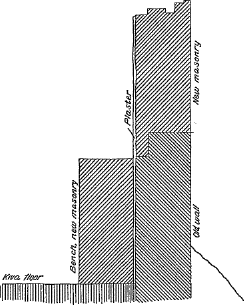
Fig. 22—Section of a kiva wall.
The section shows that the original walls were not so thick as the present ones, and that there was formerly a slight setback in the wall of 2½ or 3 inches at the level of the present bench, reducing the thickness of the wall by that amount. The original outside wall on the east extends only 6 inches above this setback. The upper portion of the exterior wall was added at the same time that the bench was constructed and is the same thickness as the lower part of the original wall. Figure 22 will make clear the changes which have taken place.
There was a recess of some kind in the original wall on the east and a similar one on the west side, but they have been filled up by the later additions. The upright logs which were built into the masonry are incorporated in the older walls. Under the floor, and apparently under the walls themselves, there is a layer nearly a foot thick of loose débris consisting of cornstalks, corn leaves, ashes, and loose dirt. The floor of the east circular room, which still covers about half the interior, rests similarly on a layer of ashes. The expedients employed to hold the front walls of these kivas in place are later discussed at some length.
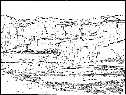
Fig. 23—Ruin No. 10 on a ledge in a cove.
Figure 23 shows the character of site occupied by a village ruin of some size situated in the first cove in the cliff wall below the mouth of Canyon del Muerto. The cliff here is about 300 feet high and the ruin is located on a ledge in a cove about 70 feet above the stream bed. Although seemingly very difficult to reach, the ruin is of comparatively easy access without artificial aid. The cavity was caused apparently by the occurrence of a pocket of material softer than that about it, and this softer material has weathered out, showing very strongly the lines of cross bedding, which, in the massive rock on either side, have been almost entirely obliterated. The strata are inclined at an angle and the edges project from a few inches to about a foot, forming a series of
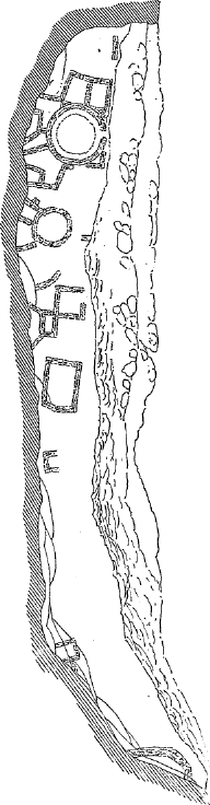
Fig. 24—Ground plan of ruin No. 10. Horizontal View
The bench on which the ruin occurs is about 250 feet long and generally about 20 feet wide, the surface being almost flat. There are structures on the extreme northern and on the extreme southern ends, but a considerable part of the intermediate area was not occupied. Reference to the ground plan (figure 24) will show that most of the buildings occur on the northern half of the ledge, which was fairly well filled by them. Many of the walls in this portion are apparently underlaid by a foot or more of ashes, sheep dung, domestic refuse, cornhusks, etc.
The room which is shown in the center of the plan, at the southern end of the main group, stood alone and was the largest rectangular room in the village. It covered an area 15 feet by 9 feet inside the walls, which are now 5 or 6 feet high. The masonry is very good, although chinking with spalls was but slightly employed to finish the exterior; inside it is more apparent. The western wall was built over the edge of the sloping rock forming the back of the cove, as shown on the plan, and this rock projects below the wall into the room. There were apparently no openings in the walls, except some very small ones on the
There were two circular kivas in the village, one of which was unusually small, being only about 10 feet in diameter north and south; the east-and-west diameter is a trifle smaller. There was apparently no bench in the interior, but on the western or northwestern side there is a bench-like recess of about a foot which occupies 7 feet of the circumference. The whole interior was covered with a number of washes of clay, applied one over another, forming a coating now nearly three-quarters of an inch thick. This is cracked and peeled off in places, and in the section eighteen coats, generally about one thirty-second of an inch thick, may be counted. Each coat or plastering is defined by a film of smoke-blackened surface.
On a level about 2 feet above the bench and about 5 feet above the present ground surface, there seems to have been some kind of roof. The stones here project into the interior slightly beyond the wall surface, and the plaster seems to curve inward. This point or level is from 6 to 18 inches below the top of the wall, and here there are remains of occasional small sticks, about an inch in diameter, which projected into the kiva. They are irregularly disposed figure 72.
The exterior wall of the kiva was very roughly laid up, and some of the lower stones were set on edge, which is rather an anomalous feature. There is no evidence that the structure was ever inclosed in rectangular walls, as was the usual custom; in fact, the occurrence of other walls near it would apparently preclude such an arrangement. The wall which runs north or northwest from the kiva, joining it to the cliff wall behind, is pierced by a doorway some feet above the ground, and in front of or below this doorway there is a buttress or step of solid masonry, shown on the plan. There was apparently an open space between this doorway and the next wall to the north. The room entered through the doorway was very small, and its roof, formed by the overhanging cliff, is much blackened by smoke.
The main or north kiva was 15 feet in diameter on the floor, with a bench a foot wide extending around it. The external diameter is over 20 feet. The interior was decorated by bands and dots in white, which are described at length in another place (page 178). The roof was 5½ feet above the bench, and there is a suggestion that it rested on a series of beams extending north and south, but this is not certain.
On the southeastern side, at the point where the kiva comes nearest the edge of the cliff, there was a narrow opening or doorway not more than 15 inches wide. This was the only entrance to the interior, except through the roof, and it opens directly on the edge of the cliff, so that it is very difficult, although not impossible, to pass it. In front of the opening a little platform was built on the sloping edge of the cliff, as though entrance was had from the lower bench by artificial means, but it is more probable that this feature is all that remains of a chimney-like structure.
Above this kiva there was apparently a living room, the walls of which, where they still remain on the north and west sides, were approximately straight, but the corners were rounded. The roof was formed by the overhanging cliff and the interior walls were whitewashed. The kiva walls were about 18 inches thick, but on the west side, in the small room between the kiva and the cliff, the masonry is much heavier, the lower part extending into the room a foot farther than the upper. This is caused by the wall of the second-story room above setting in toward the east or center of the kiva. This upper wall was supported by a beam, part of which is still in place. The small room behind is much blackened by smoke.
The exterior wall of the main kiva on the northwest side is very rough. On the northeast and southeast, however, it is covered by straight walls which are well finished. The western end of the north
The site of these ruins commands an extensive prospect, including several small areas of good bottom land, one of which lies directly in front of it; but the number of other ruins in the cove suggests that there was once a much larger area of bottom land here, and this suggestion is supported by the presence of several large cottonwood trees, now standing out in the midst of the sand, in the bed of the stream, where these trees never grow. Some of these trees are not yet entirely dead, indicating that the change in the bed of the stream was a recent one. Against the foot of the talus, just above the ruin, there is a narrow strip of bottom land, about 3 feet above the stream bed, and on it a single tree, still alive, but inclined at an angle. In the stream bed, above and below the ruin, there are large trees, of which only one or a few branches are still alive. The position of the cove with reference to the stream bed made the bottom lands here especially subject to erosion when the stream assumed its present channel and they were gradually worn away.
The western end of the ledge was occupied by a structure whose use at first sight is not apparent. The wall, as shown on the plan, is curved, very thick and heavy, and built partly over the sloping rock forming the back of the cave. The front wall is 3 feet thick, and its top, now level, is about 5 feet above a narrow bench in front of it. There is no doorway or other opening into it, and access into its interior was had over the steep sloping rock to the north by means of hand-holes in the rock. These are shown in plate L. The interior appears to have been plastered.
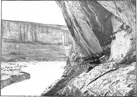
Plate L. Reservoir in Ruin No. 10
This structure measures 15 by 5 feet inside, there being no wall on the north, as the east wall merges into the sloping rock. The foot-holes in the rock, before referred to, are at this end, nearest the village, and appear to be in several series. The structure is so situated that the sun shines on it only a few hours each day, and it seems more than probable that it was a reservoir. The bed of the stream, the channel followed in low water, sweeps against the base of the cliff below this point, and by carrying water 20 feet it would be directly beneath and about 50 feet below it. Finally, the cliff wall above this point is decorated with pictographs of tadpoles and other water symbols in common use among the pueblos, and these do not occur elsewhere on this site. In the southwestern corner of the structure, near the bottom, there was an opening about 18 inches high, which was carefully filled up from the inside and plastered. This may have been an outlet by which the water was discharged when the reservoir was cleaned out. The wall has caved in slightly above it. The mud mortar used in building this structure and the other walls was necessarily brought from below.
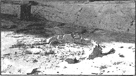
Fig. 25—Oven-like structure in ruin No. 10.
Near the center of the ledge, at the point shown on the plan, there are some remains which strongly suggest the Mexican oven. The bed rock, which is here nearly flat, was removed to a depth of about 4 inches over a rectangular area measuring 4 feet north, and south by 3½ feet. There were natural fissures in the rock on the north and west sides which left clean edges. The southern edge appears to have been smashed off with a rock. The eastern side required no dressing, as it was at a slightly lower level, and it was to reach this level that the rock was removed. In the rectangular space described there was a circular, dome-shape structure, about 3 feet in diameter, composed of mud and sticks, with a scant admixture of small stones. This is shown in figure 25, and in plan in figure 26. The walls were about 3 inches thick, and from their slope the structure could not have been over 3 feet high. The mud which composed the walls was held together by thin sticks or
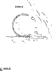
Fig. 26—Plan of oven-like structure.
If this structure was a dome-shape oven, and it is difficult to imagine it anything else, its occurrence here is important. It is well known that the dome-shape oven, which is very common in all the pueblos, in some villages being numbered by hundreds, is not an aboriginal feature, but was borrowed outright from the Mexicans. If the structure above described was an oven, it is clear evidence of the occupancy of these ruins within the historic period—it might almost be said within the last century. No other structure of the kind was found in the canyon, however, and it should be stated that the ovens of the pueblos are as a rule rather larger in size than this and usually constructed of small stones and mud—sometimes of regular masonry plastered. There is a suggestion here, which is further borne out by the chimney-like structures to be discussed later, that only the idea of these structures was brought here, without detailed knowledge of how to carry it out—as if, for example, they were built by novices from description only.
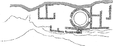
Fig. 27—Ground plan of a small village, ruin No. 16.
Figure 27 is the ground plan of a small village ruin situated at the mouth of Del Muerto at the point marked 16 on the map. The site, which is an excellent one, but rather difficult of access, overlooks the bottom land at the junction of the canyons and a long strip on the opposite side, together with a considerable area above. The approach is over smooth sandstone inclined at such an angle as to make it difficult to maintain a footing, but the ruin can be reached without artificial aid.
The village was not of large extent and contained but one kiva, but the walls were well constructed and the masonry throughout is exceptionally good. The exterior wall of the western rooms was constructed of small stones neatly laid. The eastern room of the two was built after the other, and entrance was had by an almost square opening 2 feet from the ground. To facilitate ingress, a notch was dug in the wall about 8 inches from the ground. There was no communication between the rooms, the western room being entered by a small doorway on the western side, about 8 inches from the ground, 3 feet high and 14 inches wide. There was no plastering in the interior of these rooms.
The kiva is 15 feet in diameter on the floor, and about 23 feet in its exterior diameter. The walls are 3 feet thick above the bench level and 4 feet
On the south side of the kiva and outside the rectangular wall is a square buttress or chimney-like construction, 4 by 3 feet, inclosing a shaft 10 by 5 inches. This feature will be discussed in another place. It was added after the wall was completed, and embedded in it, about a foot from the ground, is a heavy beam about 5 inches in diameter. Plate LI, which shows the whole front of the village, will make this feature clear. The beam projects from the kiva wall at or under the floor level, and seems to have no reference to the shaft, which is, however, shouldered to accommodate it. Similar beams project from the walls to the east, about 8 inches above the bed rock.
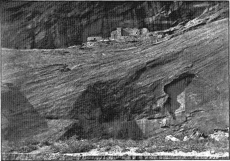
Plate LI. Small Village, Ruin No. 16, Canyon De Chelly
In the room east of the kiva no doorway was found. The walls are still intact to a minimum height of 6 feet from the floor, except in the southeast corner, where they are 3 feet. The opening described, which occurs in the southwest corner of the room, was 4 feet from the floor; and in the southeast corner, where the wall is broken down, there now
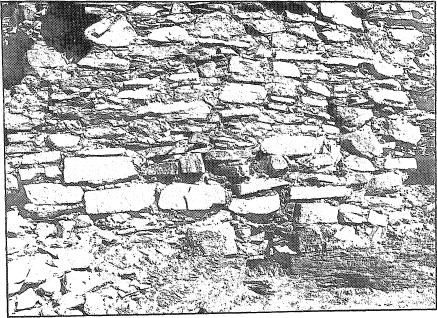
Plate LII. Walls Resting on Refuse in Ruin No. 16
West of the kiva and on the extreme edge of the cliff are the remains of two small apartments, a trifle below the surface of the ledge and with a 3-foot wall on the south. These are too small for habitations, and were used probably for the storage of corn. About 100 feet west of the group described, on the same bench, there are remains of a large room, divided into two, and of quite rough construction. It contains several Navaho dead and may be of Navaho origin.
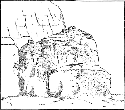
Fig. 28—Ruins on a large rock.
A type of site which is abundant in the San Juan country and is found in other regions, but is very rare in this, is shown in figure 28.
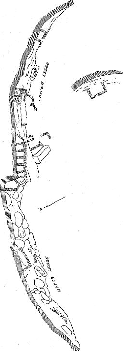
Fig. 29—Ground plan of ruins No. 49 Horizontal View
At the point marked 49 on the map there is a ruin or group of ruins which presents some anomalous features. Figure 29 shows in detail the distribution of the remains. The rooms were located on narrow benches in the cliff, the principal part on a high, narrow bench, 40 or 50 feet above the top of the talus and over 300 feet above the canyon bottom. Access to the upper ledge from the top of the talus is exceedingly difficult, requiring a climb over almost vertical rock for 40 feet. Above the ledge there is massive sandstone, but below it for 100 feet or more there is an area of cross bedding, and the rock has an almost vertical cleavage,
At the northern end of the upper ledge there are five small cells occupying its whole width, and whose front wall follows the winding ledge. The walls are about 5 feet high, and their tops bear the marks of the poles which carried the roof. There are no exterior openings, nor is there any evidence of a means of communication between the rooms; but in the second room from the south two stones project from the wall inside, near the southeastern corner, forming rude steps, doubtless to a trapdoor in the roof. These cells could hardly have been used as habitations. The floors are covered with many lumps of clay, which apparently formed part of the roof.
To the south of this cluster of cells there was a large room of irregular shape on a level about 8 feet higher. The remainder of the ledge, which is about on the same level as this large room, is almost covered with large bowlders, but at several points on it other remains of walls occur. The largest room of all was near its center. It was built against the cliff, which formed one of its sides, and measured about 16 by 6 feet. There are no evidences of any partitions or roof, the latter probably being formed by the overhanging rock. As the room was built partly on the sloping rock, the floor is very uneven. It could hardly have been used as a habitation, but may have been employed for the storage of water.
The southern end of the lower ledge merges into the head of the talus, the northern part drops down by a sharply sloping and in places an almost vertical wall of about 30 feet; thence it descends to the bottom by a long slope of bare rock, generally passable on foot. The lower ledge is about 50 feet above the upper. Upon it are scattered the remains of a few rooms of the same general character as those above, but smaller. Many of these have been utilized for modern Navaho burials, and perhaps some of them were constructed for that purpose. If these rooms were used as habitations, it must have been under very peculiar circumstances; moreover, the site is hardly suited for such a purpose, having the sunshine less than half of the day. In this respect it is anomalous.
At the southern end of the ledge there is a large angular bowlder, one edge of which rests against the cliff wall and is free from the ground. Under this the walls of a small room can be seen. The cliff formed one side of the room and the bowlder acted as a roof. On the extreme northern end of the ledge, 200 feet distant from the nearest room, there are remains of a structure standing alone. The masonry is much rougher than that of the other rooms, and, although the walls are now about 6 feet high, there is no evidence of any doorway or opening into the room.
The location and character of this site and the character of the remains suggest that most if not all of the rooms which can now be traced were used for storage only. For this purpose the site is well adapted. But the remains of the circular kiva at the foot of the lower
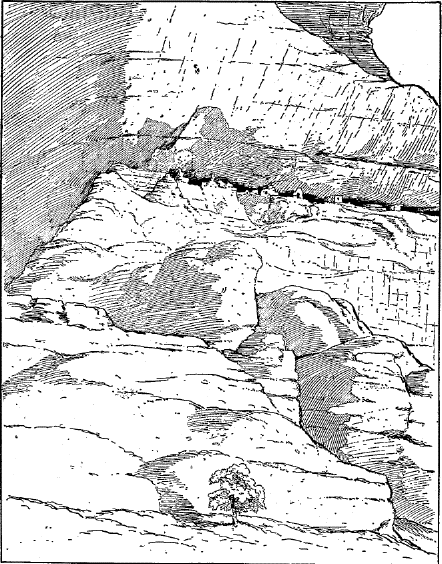
Fig. 30—Ruin on an almost inaccessible site.
Figure 30 shows one of the most inaccessible sites in the canyon. It occurs at the point marked 62 on the map, where there is a narrow ledge nearly 400 feet above the stream. The approach is over bare rock, sharply sloping, but passable at two points by an active man accustomed to climbing. Both of these points are near the western or left-hand end of the ruin; toward the right the rock becomes vertical. Immediately below this ruin there are the remains of a large settlement on a low spur near the stream, now much obliterated, and above and below it on suitable sites there were a number of small settlements which may have been connected with it.
There were a number of rooms scattered along the ledge which appear to have been used as habitations. The overhanging cliff is so close that in a number of cases it formed the roof of the room, and the whole site was an inconvenient and dangerous one. The rooms on the east rest on a large block which has split off from the wall since the walls were built, and now hangs apparently ready to drop at any moment.
At the time this site was inhabited access was had over the smooth rounded rock on the west. Here hand and foot holes have been pecked in the steep places, but as the rock is much exposed to atmospheric erosion these holes are now almost obliterated. After ascending the rock the village was entered through a doorway in a wall of exceptional thickness, shown on the left of the drawing. The room which was entered through this doorway appears to have been placed at this
The site commands an extensive outlook over the canyon bottom, including several areas of cultivable land, and while it may have been occupied as a regular village, such occupancy could not have been long continued. Altogether the site and the character of the house remains are anomalous and doubtless resulted from anomalous conditions.
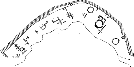
Fig. 31—Ground plan of a large ruin in Canyon del Muerto.
Figure 31 is a ground plan of a large ruin in Del Muerto. It occupied almost the whole available area of the ledge on which it is situated, and over 40 rooms can now be made out on the ground, in addition to 3 circular kivas. The settlement may have comprised between 80 and 100 rooms, which would accommodate 15 to 20 families. The size is very unusual, and the presence of but 3 kivas would indicate that the families were closely related. There are other examples of this character in the canyons, but not so large as the one illustrated.
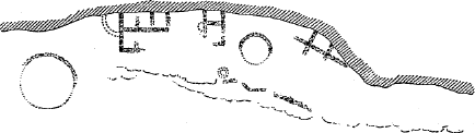
Fig. 32—Ground plan of a small ruin in Canyon del Muerto.
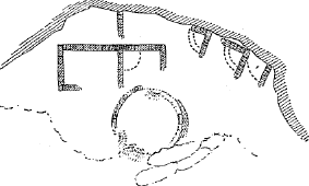
Fig. 33—Ground plan of a small ruin.
Figure 32 illustrates a type which is more common. Here we have the usual arrangement of rooms along the cliff, with a kiva in front of them. There were altogether not over 10 or 12 rooms, and they were probably occupied by one family. Figure 33 shows a kind rather more abundant than the last, and consisting like it of one circular kiva with rooms back of and between it and the cliff. Ruins of this type are generally well protected by an overhanging cliff. Figure 34 is another example, in
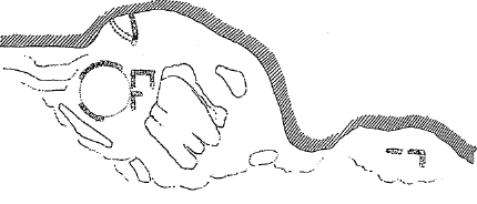
Fig. 34—Plan of a ruin of three rooms.
Figure 35 is a ground plan of a small ruin which occurs at the point marked 36 on the map. It is situated in a shallow cove at the head of the talus, 200 or 300 feet above the bottom, and is of comparatively easy access. There is but a small amount of cultivable bottom land immediately below it, but it commands extensive areas on the opposite site of the canyon and in the lower part of a branch on that side. There are but few remains of rooms other than parts of two kivas, but there is no question that there was at one time a considerable number here. Both kivas had interior benches, and were of small size, plastered in the interior. The masonry is fair to good. On the highest point of the bowlder shown on the right of the plan there is a fragment of compacted sheep dung and soil, which is now 6 feet above the ground. It is all that remains of a layer of some thickness which must have been deposited when the surface was filled up to or nearly to the top of the rock. Possibly there was a wall outside and only the intermediate space was filled.
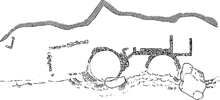
Fig. 35—Ground plan of a small ruin, with two kivas.
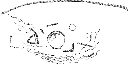
Fig. 36—Ground plan of a small ruin, No. 44.
Figure 36 is the ground plan of a somewhat similar ruin which occurs at the point marked 44 on the map. It is situated on the top of the talus, against the cliff, and commands a fine outlook over the cultivable lands in the cove below it and on the canyon bottom proper. There are but few wall remains, but two kivas can still be made out. There is no ledge here, and the walls were built on loose debris of rocks and talus. The builders had some trouble in holding the walls in place, and only partly succeeded in doing so. About one-half of the principal kiva is standing, showing masonry composed of exceptionally large stones, roughly chinked. The other, or western kiva, was similarly constructed, and both had interior benches. The front of the western kiva fell out, the builders being unable to tie it or to hold it in place on its loose foundation, and other walls were constructed inside of it, as shown on the plan. There were other walls outside the main kiva, apparently rectangular inclosing walls. This example is interesting because the masonry was constructed on a foundation of loose debris, not on bed rock, and the knowledge possessed by the builders was not sufficient to enable them to overcome the natural difficulties of the site.
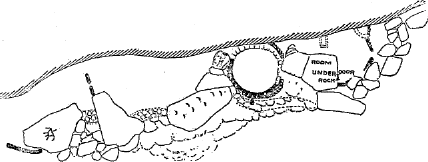
Fig. 37—Ground plan of a ruin on a rocky site.
Figure 37 shows a small ruin similar to those described, but located on a site almost covered with large bowlders. The principal structure now remaining is a circular kiva, which, contrary to the usual plan, was placed close up against the cliff; possibly the cliff formed part of the back wall. Large bowlders so closely hemmed in the structure that there was neither space nor necessity for an inclosing wall. The kiva was benched for about half of its circumference.
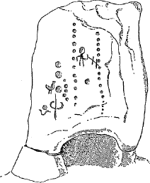
Fig. 38—Rock with cups and petroglyphs
Under the large bowlder to the right of the kiva a complete room had been built, with a doorway of the usual type through the front wall. Scattered remnants of other walls may be seen here and there, but none show well-defined rooms. Petroglyphs are quite numerous, and one small bowlder to the left of and next to the kiva is covered with cups, dots, and carvings. It is shown in figure 38.
Figure 39 shows a ruin where the site was not so restricted. One well-defined room and two kivas still remain, and there are traces of other chambers. The main kiva formed part of a compact little group of rooms, of which it occupied the front, and appears to have been inclosed by a curved wall of rough construction. A curved inclosing wall is an anomalous feature, and it is not at all certain that it occurs here, as the wall is so much broken down that its lines can not now be clearly made out. Excavation would doubtless determine this, as the whole site has been much filled up with sand and loose earth.
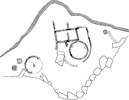
Fig. 39—Ground plan of a ruin in Canyon de Chelly.
The second kiva, which was about the same size as the first, was situated some little distance from the other, and on the outer edge of the little platform or bench on which the settlement was located. It still shows about half of its wall. The rectangular room near the main kiva still stands to a height of 3 and 4 feet. The wall nearest the kiva is pierced by a number of small openings, and by a neatly finished double-notched doorway, which is illustrated in another place (figure 67).
The whole front of the site has been filled up to a probable depth of several feet, and a number of Navaho burials have been made on it.
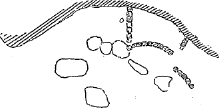
Fig. 40—Site showing recent fall of rock.
Although many of the sites are covered with bowlders and blocks of stone fallen from above, which often occur among and even over walls, close inspection generally shows that the walls were constructed after the rocks fell. There are two instances, however, which are doubtful, and in one (shown in figure 40) it appears that large blocks of rock have fallen since the walls were constructed. Such falls of rock are not uncommon now in the fall and winter months, when frost and seepage from the melting snow sometimes split off huge fragments.
The site mentioned occurs at the point marked 47 on the map. It is in a cove under a mass of rock which juts out from the cliff, and is about 30 feet above the bottom, on the edge of a slope of loose rock which extends some distance above it. At the top of the talus, over 200 feet above, there is another ruin, which was probably only an outlook, as no trace of a kiva can be found, and it is possible that the lower site was connected with and formed part of the upper one. The lower site contained a circular kiva, only a small portion of which now remains, and the ground is covered with blocks of rock which must have fallen since the walls were built. They appear to have fallen quite recently. It can still be seen that the kiva had an interior bench, and that there was a room, or perhaps rooms, between it and the back of the cove; but beyond this nothing can now be made out.
There are many favorable sites in the branch canyons, but not many of them are occupied, possibly because in the upper parts of these canyons the bottom land is of small area and is sometimes rough, being composed of numerous small hillocks. The flat bottom lands of the canyon proper are much easier to cultivate, but the sites in the side canyons offered much better facilities for defense. Figure 41 shows the plan of a ruin which occurs at the point marked 69 on the map, on the western side of a branch canyon through which passes the trail to Fort Defiance. It is situated in a shallow cove at the top of the talus and overlooks an extensive area of fine bottom land below it. At the eastern end there is a single room about 10 feet long; its front wall extends up to the overhanging rock, which forms the roof of the room. A small cist has been built against it on the west.

Fig. 41—Ruin No. 69, in a branch canyon.
About 60 feet west, on the same ledge, there are remains of other rooms which rested probably on the talus. Several rooms can be made out, but only one shows standing walls. This is on the western end, and the walls are now about 5 feet high. Four feet from the top of the wall there is a clear line of demarcation extending horizontally across it. Below this line the masonry consists of large flat slabs of rock laid in mud mortar, which was used nearly dry and stuffed into the cracks to some extent. Above the line the stones were carefully selected and the work was well done, the whole being finished by a thin coat of plaster. There is no opening in the lower part, but in the upper part there is a neatly finished doorway 3 feet high and slightly tapering. The bottom of this opening extends 2 inches below the line, and the lintel is composed of a large slab of stone a trifle wider than the thickness of the wall, but fitted flush on the outside.
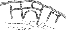
Fig. 42—Ground plan of a small ruin in Canyon del Muerto.
On a bench about 100 feet higher than the ruin described there are two small rooms, extending up to the overhanging rock above them. These rooms, which may be of Navaho origin, were reached by means of a narrow ledge extending
Figure 42 is a ground plan of a small ruin in Del Muerto in which the usual preponderance of rectangular rooms is illustrated. The site was restricted, but there is an apparent attempt to carry out the usual arrangement of a row of rooms against the cliff, with a kiva in front. Probably only three of the rooms shown were used as habitations. The plan of the kiva, which occurs in the center, was somewhat marred by a large bowlder, which must have projected into it, but apparently no attempt was made to dress off the projecting point.
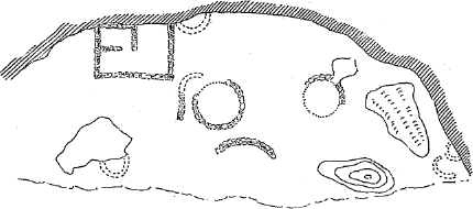
Fig. 43—Ground plan of a small ruin.
Figure 43 is the plan of a ruin located on a more open site. Only a few walls now remain, but there is no doubt that at one time more of the site was covered than now appears. There are remains of two, and perhaps of three, circular kivas.
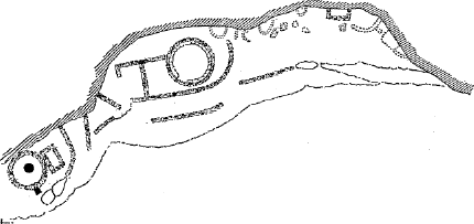
Fig. 44—Plan of a ruin with curved inclosing wall.
Figure 44 shows a ruin in which the plan is somewhat more elaborated. There are remains of several well-defined rooms, and two kivas are still fairly well preserved. The ledge is narrow and the rooms are stretched along it, with kivas at either end. That on the east was page 138). It is very rare, but in this case the evidence is clearer than in the one previously described. The western kiva, somewhat smaller than the other, was also benched, and had an exterior shaft, like those mentioned above and later described at length.
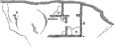
Fig. 45—Ground plan of ruin No. 34.
Figure 45 is a plan of a small ruin of the same type, which occurs in the middle region of De Chelly. It occupies the site marked 34 on the map, and is situated in a niche in a deep cove, where the outlook is almost completely obscured by a large sand dune in front of it. It comprised one circular kiva and four rectangular rooms, but, contrary to the usual result, the latter are fairly well preserved, while the former is almost completely obliterated. This may be due to the use of the rectangular rooms as sites for Navaho burial cists, of which there are no fewer than six here, and possibly the kiva walls furnished the necessary building material for the construction of the cists. The old masonry is of good quality, the outside wall being formed of selected stones of medium size, well laid and carefully chinked. Most of the walls were plastered inside. In a cleft in the rock to the right of this ruin there is a kind of cave, with foot-holes leading up the rock to it, and quite difficult of access. It formerly may have been used for storage, but at present contains only some remains of Navaho burials.
IV—CLIFF OUTLOOKS OR FARMING SHELTERS
Ruins comprised in the class of cliff outlooks, or farming shelters, are by far the most numerous in the canyon. They were located on various kinds of sites, but always with reference to some area of cultivable land which they overlooked, and seldom, if ever, was the site selected under the influence of the defensive motive. It is not to be understood that such motive was wholly absent; it may have been present in some cases, but the dominating motive was always convenience to some adjacent area of cultivable land.
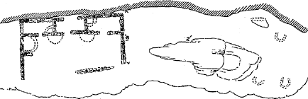
Fig. 46—Ground plan of cliff outlook No. 35.
Figure 46 is the plan of an outlook in the same cove as the last example of village ruin illustrated, and only 200 or 300 yards south of it. It may have been connected with that ruin, but could not in itself have been a village, as there are no traces of a kiva on the site, and hardly room enough for one on the bench proper. At the extreme northern end there are traces of walls on the rocks at a lower level.
The walls which were at right angles to the cliff were not carried back to it after the usual manner, but stopped about 3 feet from it, and the rooms were closed by a back wall running parallel to the cliff, and about 3 feet from it. This wall rises to a height of about 4 feet before it meets the overhanging cliff, and consequently there is a long narrow passageway, about 3 feet high and 3 feet wide on the bottom, between it and the cliff. A small man might wriggle through, but with difficulty.
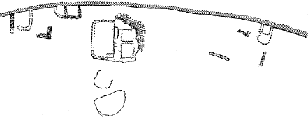
Fig. 47—Plan of a cliff outlook.
Figure 47 shows a ruin located at the point marked 37 on the map. There is a high slope of talus here, the top of which is flat and of considerable area.
The ruin is invisible from below in its present condition, but the site commands a fine outlook over several considerable areas of bottom land. The walls are now much obliterated and worked over by the Navaho, but the remains are scattered over quite an extensive area and may have been at one time an extensive settlement; however, no traces of a kiva can now be seen. Marks on the cliff show that some of the houses had been three stories high. Some places on the cliff, which were apparently back-walls of rooms, were plastered and coated with white, and there are many pictographs on the rock. The masonry is of fair quality, but the stones were laid with more mortar than usual.
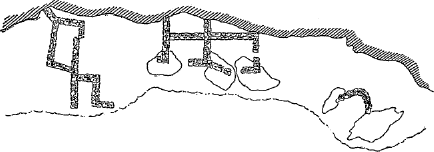
Fig. 48—Plan of cliff ruin No. 46.
Figure 48 is a ground plan of a ruin which occurs at the point marked 46 on the map. It is situated in a cove in the rock at the top of the talus, 300 or 400 feet above the bottom, and immediately above the rectangular single room described and illustrated on page 151. It commands an extensive outlook over the bottom lands on both sides of the canyon and above. The cove is about 40 feet deep, and, though so high up, has been used as a sheep close, and doubtless some of the walls have been covered up. Four rooms are still standing in two little clusters of two rooms each. The walls of the rooms on the west are composed of large stones laid in plenty of mud mortar and plastered inside and out; those of the eastern portion were built of small stones, chinked but not plastered. One of the rooms is blackened by smoke in the corner only, as though there had been some chimney structure here, which subsequently had fallen away. The cliff walls back of the eastern part are heavily smoke-blackened; back of the western portion there are no stains. There is now no trace of a circular kiva, but there is a heavy deposit of sheep dung on the ground which might cover up such traces if they existed. This site commands one of the best outlooks in the canyon, but access, while not very difficult, is inconvenient on account of the great height above the bottom.
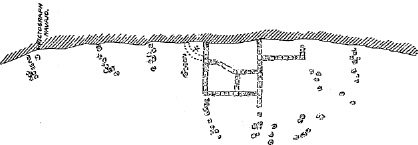
Fig. 49—Plan of cliff room with partitions.
Figure 49 shows a common type of ruin in this class. The original structure appears to have contained one or two good rooms, which by subsequent additions have been divided into several. These later additions may have been made by the Navaho, who used the building material on the ground; at any rate the structure is now merely a cluster of storage cists.
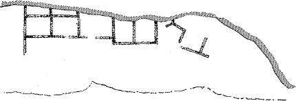
Fig. 50—Plan of a large cliff outlook in Canyon del Muerto.
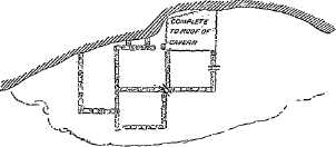
Fig. 51—Plan of a cluster of rooms in Canyon del Muerto.
One of the most extensive ruins of the cliff-outlook type situated in Canyon del Muerto is shown in figure 50. The plan shows at least eight rooms stretched along the cliff at the top of the talus. Figure 51 shows five rooms arranged in a cluster. One of these is still complete, the walls extending to the overhanging rock above which formed the roof. It will be noticed that the front room was set back far enough to allow access to the central room through a doorway in the corner. This was a convenience, rather than a necessity, for many of the rooms in ruins of this class were entered only through other rooms or through the roof, and a direct opening to the outer air was not considered a necessity; probably because these rooms in the cliff, which have been termed outlooks, were not in any sense watch towers, but rather places of abode during the harvest season, where the workers in the field lived when not actually employed in labor, and where the fields tinder cultivation could always be kept in view—an arrangement quite as necessary and quite as extensively practiced now as it was formerly.
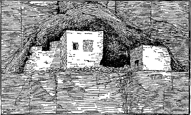
Fig. 52—White House ruin in Tseonitsosi canyon.
Figure 52 shows a cluster of rooms in the little canyon called Tseonitsosi. This is another Casa Blanca, or White House, and, oddly enough,
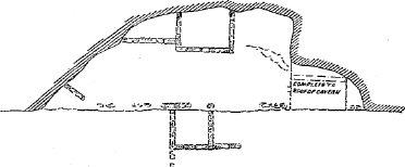
Fig. 53—Ground plan of a ruin in Tseonitsosi canyon.
Apparently some effort at ornamentation was made here. The whitewash was not applied to the fronts of the two back rooms so as to cover
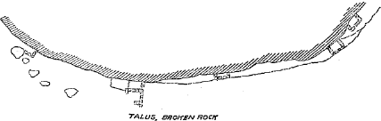
Fig. 54—Plan of rooms against a convex cliff.
Figure 54 shows an arrangement of rooms along a narrow ledge at the top of the talus, where the cliff wall is not coved or concave, but convex. Some of these little rooms may have been used only for storage, but others were undoubtedly habitations. Figure 55 shows an example in which the back wall is curved, as though it was either built over an old kiva or an attempt was made to convert a rectangular room into a kiva. There were originally three rooms in the cluster, only one of which remains, but that one is of unusual size, measuring about 15
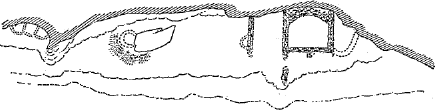
Fig. 55—Small ruin with curved wall.
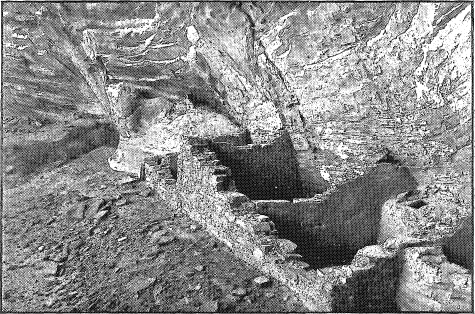
Plate LIII. Cliff Outlook in Lower Canyon De Chelly
Plate LIII shows an outlook in the lower part of De Chelly, at the point marked 6 on the map. The lower part of the cliff here flares out slightly, forming a sharp slope; where it meets the vertical rock there is a small bench, on which the ruin is situated. It is apparently inaccessible, but close examination shows a long series of hand and foot holes extending up a cleft in the rock, and forming an easy ascent. The site commands a good outlook over the bottom lands.
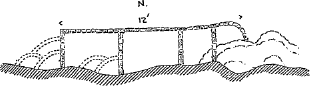
Fig. 56—Ground plan of a cliff outlook.
The ruin consists of three rectangular rooms arranged side by side against the cliff, and a kind of curved addition on the east. Figure 56 is a ground plan. The walls are still standing from a foot to 4 feet high, and produce the impression of being unfinished; although carefully chinked, they were neither plastered nor rubbed down. The two western rooms were built first, and the eastern wall extends through the front. East of these rooms there is a small rectangular chamber, and east of this again a low curved wall forming a little chamber or cist of irregular form (not shown in the plan). The front wall was extended beyond this and brought in again to the cliff on a curve, forming another small cist of irregular shape. This and the little chamber west of it were doubtless used for storage. They resemble in plan Navaho cists, but the masonry, which is exactly like the other walls here, will not permit the hypothesis of Navaho construction. Except for some slight traces in the northwest corner of the west room, there are no smoke stains about, nor are there any pictographs on the cliff walls. The western room was pierced by a window opening which was subsequently filled up, possibly by the Navaho, who have five burial cists here.
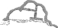
Fig. 57—Plan of cliff outlook No. 14, in Canyon de Chelly.
Figure 57 is the plan of a small outlook which occurs at the point marked 14 on the map. Opposite the mouth of Del Muerto there is an elevated rocky area of considerable extent, perhaps 50 feet above the bottom, but shelving off around the edges. Near the cliff this is covered by sand dunes and piles of broken rock; farther out there is a more level area covered thinly with sand and soil, and here there is a large ruin of the old obliterated type already described (page 93).
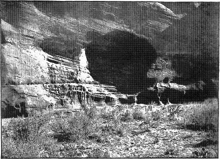
Plate LIV. Cliff Ruin No. 14
The masonry is fair and the surface is finished with plaster. The open space in front of the small back room and the outer wall of the room itself are much blackened by smoke, as though the inhabitant lived here and used the small room only to store his utensils and implements. A small room on the east must have been used for a similar purpose. Both of these rooms were entered through narrow doorways opening on the principal space. The site is an ideal one for a lookout, but not well suited for a habitation. Plate LIV shows its character.
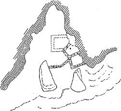
Fig. 58—Ground plan of outlooks in a cleft.
Cliff outlooks are often found on sites whose restricted areas preclude all possibility that they formed parts of larger settlements since obliterated. The ruin just described is an example. Another instance which occurs in Del Muerto is shown in figure 58. Here a deep cleft in the rock was partly occupied by two or three rooms. There was room for more, but apparently no more were built. There was not room, however, for even a small village. There are several other examples in the canyon almost identical with these, but this type is not nearly so abundant as the succeeding. Figure 59 is a plan of a
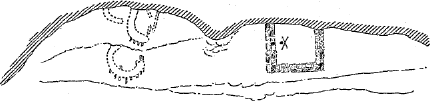
Fig. 59—Plan of a single-room outlook.
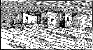
Fig. 60—Three-room outlook in Canyon del Muerto.
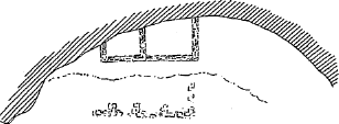
Fig. 61—Plan of a two-room outlook.
Figure 61 is a ground plan of an example containing two rooms, which occurs below the large ruin described before (No. 31, page 119), and figure 62 shows an example with one room, obscured and built over with Navaho cists. This site is located in the upper part of the canyon, on top of the talus, about 100 feet above the stream, and commands an outlook over several areas of bottom land on both sides. The walls are built about 10 feet high, and are composed of medium-size stones laid in courses and carefully chinked with small spalls. The southwestern corner of the room is broken down, but the eastern wall is still standing, and shows a well-finished opening on that side. There are several Navaho burial cists on this site.
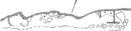
Fig. 62—Plan of outlook and burial cists, No. 64.
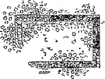
Fig. 63—Plan of rectangular room No. 45.
Figure 63 is the plan of a type of ruin which is rather anomalous in the canyon. It occurs at the point marked 45 on the map, and occupies a small flat area almost on top of the talus 300 feet or more page 144 (figure 48), and hardly 20 feet distant from it, and yet it does not appear to have been connected with it. It consists of a single large room, 20 feet long by 11½ feet wide outside, and the site commands an extensive prospect over bottom lands on both sides of the canyon, and above, but the only opening in the wall on that side is a little peephole 6 inches square and 2 feet from the ground. This is sufficient, however, to command nearly the whole outlook. There is a doorway on the eastern side, one side of which, fairly well finished, remains. There was apparently no other opening, unless one existed on the western side, where, in the center, the wall is broken down to within 2 feet of the ground. Along the western side of the room, at the present ground surface, there are remains of a bench about a foot wide; the eastern side is covered above this level.
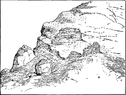
Fig. 64—Rectangular single room.
The masonry is very rough and chinked only with large stones. The interior is roughly plastered in places, and small pieces of stone are stuck on flat. The corners are rounded. Externally the masonry has the appearance of stones laid without mortar, like a Navaho stone corral, and were it not for the occurrence of other similar remains, it might be regarded as of Navaho or white man's construction, as the size,

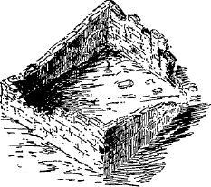
Fig. 65—Single-room remains.
Somewhat similar wall remains are seen in places on the canyon bottom, where they are always of modern Navaho origin, and it is quite possible that the ruins above mentioned should be placed in the same category. It will be noticed that in the plan the doorway or entrance opening is on the eastern side—an invariable requirement of Navaho house constructions; but it is only within recent times that the Navaho have constructed permanent, rectangular abodes, and even now such houses are rarely built. It is difficult to understand, moreover, why recourse should be had to such inconvenient sites, if the structures are of Navaho origin, as these Indians always locate their hogans on the bottom lands, or on some slight rise overlooking them.
Distributed throughout the canyons, wherever a favorable situation could be found, there are a great number of sites resembling those of the cliff outlooks, but showing now no standing wall. There is always some evidence of human occupancy, often many pictographs on the back wall, as in an example in the lower part of the canyon shown in plate LV. This occurs at point 2 on the map, in a cove perhaps 100 feet across, with caves on the northern and southern sides.
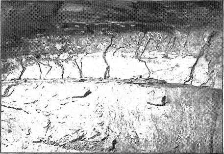
Plate LV. Site Marked by Pictographs
In the southern cave there are no traces of masonry, but the back of the cave is covered with hand prints and pictographs of deer, as shown in the plate. In the northern cave there are traces of walls. Many of the sites do not show the faintest trace of house structures; some of them have remains of storage cists, and many have remains of Navaho burial cists, associated with pictographs not of Navaho origin. Some idea of the number and distribution of these sites may be obtained from the following list, wherein the numbers represent the location shown on the detailed map: 2, 8, 9, 11, 18, 19, 21, 22, 23, 25, 26, 30, 38, 39, 40, 42, 43, 53, 54, 57, and 66—in all 21 sites which occur between the mouth
DETAILS
SITES
The character of the site occupied by a ruin is a very important feature where the response to the physical environment is as ready and complete as it is in the ancient pueblo region. This feature has not received the attention it deserves, for it is more than probable that in the ultimate classification of ruins that will some day be formulated the site occupied will be one of the principal elements considered, if not the most important. The site is not so important per se, but must be considered with reference to the specific character of the ruin upon it, its ground plan, the character of other ruins in the vicinity which may have been connected with it, and its topographic environment. The character and ground plan of a cliff ruin would be so much out of place on an open valley site that it would immediately attract attention. The reverse is equally remarkable.
Considering all that has been written about the cliff ruins as defensive structures, it is strange how little direct evidence there is to support the hypothesis; how few examples can be cited which show anything that can be construed as the result of the defensive motive except the general impression produced on the observer. Nor, on the other hand, do these ruins as a whole give any support to the theory that they represent an intermediate stage in the development of the pueblo people. Some few may, perhaps those examined by Mr F. H. Cushing south and east of Zuñi do; but more than 99 per cent of them give more support to a theory that they are the ultimate development of pueblo architecture than to the other hypothesis, for they contain in themselves evidence of a knowledge of construction equal and even superior to that shown in many of the modern pueblo villages. The only thing anomalous or distinctive about the cliff ruins, considered as an element of pueblo architecture, is the character of site occupied. If this were dictated by the defensive motive, it would seem reasonable to suppose that the same motive would have some direct influence on the structures, yet examples where it has affected the arrangement of rooms or ground plan or the character of the masonry are exceedingly rare and generally doubtful.
It is well to specify that in the preceding remarks the term cliff ruin has been applied to small settlements, comprising generally less than four rooms, sometimes only one or two, and usually located on high and almost inaccessible sites. These are comprised in class IV of the classification here followed. Regular villages located in the cliffs or on top of the talus (class III) are a different matter. These have nothing in common with the small ruins, except that sometimes there is a similarity
An hypothesis as to the order in which sites of the various classes were occupied can not be based on the present condition of the ruins. It is more than likely that the older ruins served as quarries of building material for succeeding structures erected near them, and probably some of the cliff ruins themselves served in this way for the erection of others, for there are many sites from which the building stone has been almost entirely removed; yet there is no doubt that these sites were formerly occupied. The Navaho also have contributed to the destruction. Notwithstanding their horror of contact with the remains of the dead, quite a number of buildings have been erected by these Indians with material derived from adjacent ruins. It is evident that the gathering of this material would be a much lighter task than to quarry and prepare it, no matter how roughly the latter might be done.
In a study of some ruins in the valley of the Rio Verde, made a few years ago, a suggestion was made of the order in which ruins of various kinds succeeded one another—a sort of chronologic sequence, of which the beginning in time could not be determined. Studies of the ruins and inhabited villages of the old province of Tusayan (Moki) and Cibola (Zuñi), and a cursory examination of ruins on Gila river, show that they all fall easily into the same general order, which is somewhat as follows:
1. The earliest form of pueblo house is doubtful. As a rule, in most localities the earliest forms are already well advanced. As it is now known that the ancient pueblo region was not inhabited by a vast number of people, but by a comparatively small number of little bands, each in constant though slow movement, this condition is what we would expect to find. It is probable that the earliest settlements consisted of single houses or small clusters located in valleys convenient to areas of cultivable land and on streams or near water.
2. The next step gives us villages, generally of small size, located on the foothills of mesas and overlooking large areas of good land which were doubtless under cultivation. This class comprises more examples perhaps than any other, and many of them come well within the historic period, such as six of the seven villages of Tusayan at the time of the Spanish conquest in 1540, all of the Cibolan villages of the same date, and some of the Rio Grande pueblos of that time.
3. In some localities, though not in all, the small villages were at a later period moved to higher and more inaccessible sites. This change has taken place in Tusayan within the historic period, and in fact was
4. The final stage in the development of pueblo architecture is the large, many-storied, or beehive village, located generally in the midst of broad valleys, depending on its size and population for defense, and usually adjacent to some stream. In this class of structure the defensive motive, in so far as it affected the choosing of the site, entirely disappears. The largest existing pueblo, Zuñi, made this step early in the eighteenth century; the next largest, Taos, was probably in this stage in 1540, and has remained so since. In some cases ruins on foothill sites (2) have merged directly into many-storied pueblos on open sites (4), without passing through an intermediate stage.
There is another step in the process of development which is now being taken by many pueblos, which, although an advance from the industrial point of view, is to the student of architecture degeneration. This consists of a return to single houses located in the valleys and on the bottom lands wherever convenience to the fields under cultivation required. This movement is hardly twenty years old, but is proceeding at a steadily accelerating pace, and its ultimate result is the complete destruction of pueblo architecture. Whatever we wish to know of this phase of Indian culture must be learned now, for two generations hence probably nothing will remain of it.
This hasty sketch will illustrate some of the difficulties that lie in the way of a complete classification of the ruins of the pueblo country. It is impossible to arrange them in chronologic sequence, because they are the product of different tribes who at different times came under the influence of analogous causes, and results were produced which are similar in themselves but different in time. It is believed, however, that the classification suggested exhibits a cultural sequence and probably within each tribe a chronologic order.
In this classification no mention has been made of the cliff and cave ruins. These structures belong partly to class III, villages on defensive sites, and partly to a subclass which pertained to a certain extent to all the others. In the early stages of pueblo architecture the people lived directly on the laud they tilled. Later the villages were located on low foothills overlooking the land, but in this stage some of the villages had already attained considerable size and the lands overlooked by them were not sufficient for their needs. As a consequence some of the inhabitants had to work fields at a distance from the home village, and as a matter of convenience small temporary shelters were erected near by. In a still later stage, when the villages were removed to higher and more easily defended sites, the number of farming shelters must have largely increased, as suitable sites which also commanded large areas of good land could not often be found. At a still later
Some farming villages, such as those described above, are still in use among the pueblos. The little village of Moen-Kapi, attached to Oraibi, but 75 miles distant from it, is an example. There are also no fewer than three villages in the Zuñi country of the same class. Nutria, Pescado, and Ojo Caliente are summer villages of the Zuñi, although distant from that pueblo from 15 to 25 miles. It is significant that none of these subordinate villages possess a kiva. It is believed that the cliff ruins and cavate lodges, which are merely variants of each other due to geological conditions, were simply farming shelters of another type, produced by a certain topographic environment.
The importance which it is believed should attach to the site on which a ruin is found will be apparent from the above. It was certainly a prominent element in the De Chelly group. A study of the detailed map here published will illustrate how completely the necessity for proximity to an area of cultivable land has dominated the location of the settlements, large and small; and a visit to the place itself would show how little influence the defensive motive has exercised. Near the mouth of the canyon, where cultivable areas of land are not many, there are few ruins, but those which do occur overlook such lands. In the middle portion, where good lands are most abundant, ruins also are most abundant; while above this, as the rocky talus develops more and more, the ruins become fewer and fewer; and in the upper parts of the canyon, beyond the area shown on the map, they are located at wide distances apart, corresponding to little areas of good land so located. Not all of the available land was utilized, and only a small percentage of the available sites were built upon. Between the mouth of De Chelly and the junction of Monument canyon, 13 miles above, there are seventy-one ruins. A fair idea of their distribution may be obtained from a study of the detailed map (plate XLIII), in conjunction with the following figures:
I. Old villages on open sites occur at the points marked 12, 41, 52, 17a, 55, 60, 61, and 67; in all, nine sites; principally in the upper part of the canyon.
II. Home villages on bottom lands, located without reference to defense, occupy sites 3, 4, 17, 20, 28, 48, and 51; in all, seven sites. Probably there are many more ruins of this class and the preceding, now so far obliterated as to be overlooked or indistinguishable.
III. Home villages on defensive sites occur at the points marked 5, 10, 13, 15, 16, 27, 31, 32, 34, 36, 37, 40, 44, 47, 59, 62, and 66; in all, seventeen. This includes many sites where the settlements were very small, often only a few rooms, but there is always at least one kiva.
IV. Cliff outlooks and farming shelters occupy sites 2, 6, 7, 8, 9, 11, 14, 18, 19, 21, 22, 23, 24, 25, 26, 29, 30, 33, 35, 38, 39, 42, 43, 45, 46, 49, 50, 53, 54, 56, 57, 64, 63, 65, 68, 69, and 70; in all, thirty-seven, or more than half. Some of these sites are now marked only by Navaho remains, and possibly a small percentage of them are of Navaho making, but the sites which are clearly and unmistakably Navaho are not mentioned here. Of all the sites only one (No. 7) is actually inaccessible without artificial aid.
The absence of any attempt to improve the natural advantages of the sites is remarkable. No expedients were employed to make access either easier or more difficult, except that here and there series of hand and foot holes have been pecked in the rock. Steps, either constructed of masonry or cut in the rock, such as those found in the Mancos canyon and the Mesa Verde region, are never seen here. The cavities in which the ruins occur are always natural; they are never enlarged or curtailed or altered in the slightest degree, and very rarely is the cavity itself treated as a room, although there are some excellent sites for such treatment. The back wall of a cove is often the back wall of a village, but aside from this the natural advantages of the sites were seldom realized.
The settlements were always located with reference to the canyon bottom, and access was never had from above, notwithstanding that in some cases access from above was easier than from below. Yet the inhabitants must necessarily have obtained their supply of firewood from above, as the quantity in the canyons, especially in that part where most of the ruins occur, is very limited. The Navaho throw the wood over the cliffs, afterward gathering up the fragments below and carrying them on their backs to their hogans at various points on the canyon bottom. The crash of falling logs, dropped or pushed over the edge of a cliff, sometimes 400 or 500 feet high, is not an infrequent sound in the canyon, and is at first very puzzling to the visitor.
The canyon walls are so nearly vertical, or rather so large a proportion is vertical, that egress or ingress, except at the mouth of the canyon, is a matter of great difficulty. Near the junction of Monument canyon, 13 miles above the mouth of De Chelly, there is a practicable horse trail ascending a narrow gorge to the southeast. The Navaho call it the Bat trail, on account of its difficulties. Another horse trail crosses Del Muerto some 8 or 10 miles above its mouth. With these exceptions there is no point where a horse can get into the canyons or out of them, but there are dozens of places where an active man, accustomed to it, can scale the walls by the aid of foot-holes which have been pecked in the rock at the most difficult places. These foot trails are in constant use by the Navaho, who ascend and descend by them with apparent ease, but it is doubtful whether a white man could be induced to climb them, except perhaps under the stress of necessity. There are even some trails over which sheep and goats are driven in and out of the canyon, but anyone who had not seen the flocks actually passing over the rocks would declare such a feat impossible. Some of these trails at least are of Navaho origin. Whether any of them were
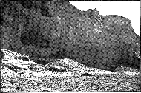
Plate LVI. Site Difficult of Approach
Plate LVI shows a characteristic site in the lower part of the canyon. It occurs at the point marked 8 on the map, and is now quite difficult of approach, owing to the wearing away or weathering of a long line of foot-holes in the sloping rock, but formerly access was easy enough. It is now marked by a cluster of Navaho burial cists. Figure 66 shows an example that occurs in De Chelly, about 8 miles
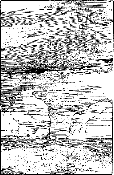
Fig. 66—Site apparently very difficult of access.
MASONRY
The ancient pueblo builder, like his modern successor, was so closely in touch with nature, so dependent on his immediate physical surroundings, that variations in some at least of his arts are more natural and to be expected than uniformity. Especially is this true of the art of construction, and variations in masonry are more often than not the result of variations in the material employed, which is nearly always that most convenient to hand. Yet there were other conditions that necessarily influenced it, such, for example, as the character of the structure to be erected, whether permanent or temporary. The summer village of Ojo Caliente presents a type of masonry much ruder than any found in the home village of Zuñi, although both were built and occupied by the same people at the same time.
Within the limits of Canyon de Chelly, where the physical conditions and the character of material are essentially uniform, a considerable variation in the masonry is found, implying that some conditions other than the usual ones have influenced it. Were the masonry of one class of ruins inferior or superior throughout to that of another it might be easily explained, but variations within each class are greater than those between classes. Conditions analogous to those which prevailed in the case of Ojo Caliente and Zuñi may have governed here, or there may have been other conditions of which we now know nothing. It may be that sites originally occupied as farming shelters subsequently became regular villages, as has happened in other regions. The position of the kivas in many of the ruins suggests this. As a whole the masonry is inferior to that found in the Mancos canyon and the Chaco, and superior to that of Tusayan, but, as in Tusayan, where the masonry is sometimes very roughly constructed, the builders were well acquainted with the methods which produced the finer and better work.
The highest type of masonry in the pueblo system of architecture consists of small blocks of stone of nearly uniform size, dressed, and laid in courses, and rubbed down in situ. No attempt was made to break joints. This system requires the careful preparation of the material beforehand, and examples of it are not very common in Canyon de Chelly. As a variant we have walls composed of stones of fairly uniform size, laid with the best face out and with the interstices chinked with small spalls. The chinking is carried to such an extent in some places, as in the Chaco ruins, that the walls present the effect of a mosaic composed of small spalls. Chinking is almost a universal practice, and in some localities had passed, or was passing, from a mere
The use of an exterior finish of plaster was conducive to poor masonry. Such plastering is found throughout the region, but it is much more abundant in the modern than in the ancient work. Perhaps we may find in this a suggestion of relative age; not in the use of plastering, but in its prevalence.
Pueblo masonry is composed of very small units, and the results obtained testify to the patience and industry of the builders rather than to their knowledge and skill. In fact, their knowledge of construction was far more limited than would at first sight be supposed. The marked tabular character of the stone used rendered but a small amount of preparation necessary for even the best masonry. For over 90 per cent of it there was no preparation other than the selection of material. The walls and buildings were always modified to suit the ground, never the reverse, and instances in which the site was prepared are very rare, if not indeed unknown. There are no such instances in De Chelly, where sites were often irregular, and a small amount of work would have rendered them much more desirable.
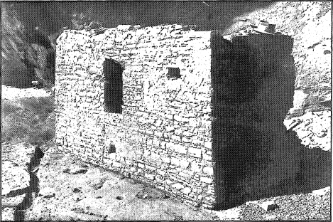
Plate LVII. Masonry in Canyon De Chelly
Plate LVII shows a type of masonry which is quite common in De Chelly. It is the west room of ruin 16, near the mouth of Del Muerto. An attempt at regularity, and possibly at decorative effect, is apparent in the use of courses of fairly uniform thickness, alternating with other courses or belts composed of small thin fragments. Beautiful examples of masonry constructed on this method occur in the Chaco ruins, but here, while the method was known, the execution was careless or faulty. Chinking with small spalls has been extensively practiced and gives the wall an appearance of smoothness and finish. A similar wall, rather better constructed, occurs at the point marked 3 on the map, and in this case the stones composing the wall were rubbed down in situ. Another wall, which occurs in the same ruin, is shown in plate LVIII. In places very large stones have been used, larger than one man could handle conveniently, but the general effect of the wall face is very good. This effect was obtained by placing the best face of the stone outward and by careful chinking.
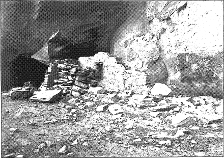
Plate LVIII. Chinked Walls in Canyon De Chelly
Chinking was sometimes done, not with slips of stone driven in with a hammer, after the usual style, but with bits of mud pressed in with the fingers. The mud was used when about the consistency of modeling clay, and bears the imprints of the fingers that applied it; even the skin markings show clearly and distinctly. From this use of mud to its use as an exterior plaster there is but a short step; in fact, examples which are intermediate can be seen throughout the canyon. In places mud has been applied to small cracks and cavities in larger quantities than was necessary, and the excess has been smoothed over the 10, will illustrate this. Here the process has been carried so far that the wall is almost plastered, but not quite. In plastered walls the process was carried a step farther, and the surface was finished by the application of a final coat of mud made quite liquid. The interior plastering of kivas was always much more carefully done than that of any other walls. Owing to blackening by smoke and recoating, the thickness of the plastering in kivas can be easily made out. Often it is as thin as ordinary paper.
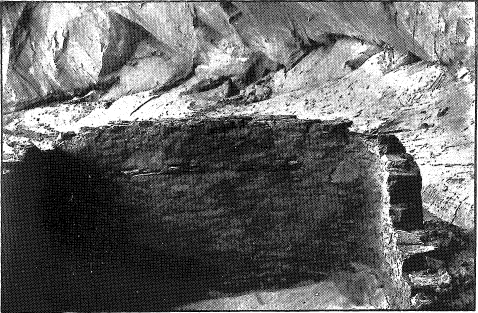
Plate LIX. A Partly Plastered Wall
Plate LX shows walls in which an abundance of mud mortar was used, and the effect is that of a plastered wall. The difference between these walls and those shown in plate LVII is only one of degree, the wall shown in plate LIX being of an intermediate type. No instance occurs in the canyon where a coating of mud was evenly applied to the whole surface of a wall, in the way, for example, that stucco is used by us. It seems probable, therefore, that the application of plaster as a finish grew out of the use of stone spalls for chinking, and its prevalence in modern as compared with old structures is suggestive. It is not claimed, however, that because we have examples of the intermediate stages in De Chelly that the process was developed there. The step is such a slight one that it might have been made in a hundred different localities at a hundred different times or at one time; but it is well to note that in any given group of ruins or locality it is likely to be later than masonry chinked with stones. Surface finishing in mud plaster is the prevailing method at the present day, and well-executed masonry of stone carefully chinked is almost invariably ancient. The use of surface plaster is largely responsible for the deterioration of stonework that has taken place since the beginning of the historic period. The modern village of Zuñi, which dates from the beginning of the eighteenth century, although built on the site of an older village, is essentially a stone-built village, though that fact would never appear from a cursory examination, so completely is the stonework covered by surface plaster.
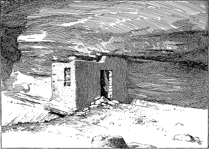
Plate LX. Plastered Wall in Canyon De Chelly
In Tusayan (Moki) walls have been observed in progress of erection. The stones were laid up dry, and some time after, when the rains came and pools of water stood here and there in pockets on the mesa top, mud mortar was mixed and the interstices were filled. This method saved the transportation of water from the wells below up to the top of the mesa, a task entailing much labor. Doubtless a similar method was followed in De Chelly, where the stream bed carries water only during a part of the year. But stone was also actually laid in mud mortar, as shown in plate LII, which illustrates a rough type of masonry.
It is probable that the practice of chinking grew up out of the scarcity of water, when walls were erected during the dry season and finished when the rains made the manufacture of mud mortar less of a task. The rough wall shown in the illustration is the outside of an interior wall of a kiva, and it was probably covered by the rectangular
Much of the masonry in the canyon is of the type described, but examples differ widely in degree of finish and in material selected. Some of the walls appear very rough and even crude, so much so that they almost appear to be the first efforts of a people at an unknown art, but a closer inspection shows that even the rudest walls were erected with a knowledge of the principles which were followed in the best ones, and that the difference resulted only from the care or lack of care employed. The rudest walls are much superior to the masonry of the Navaho cists which are found in conjunction with them and which are constructed on a different method.
Although walls were often built on sloping rock, and the builders had experience and at times disastrous experience to guide them, the necessity for a fiat and solid foundation was never appreciated. Walls were sometimes built on loose debris; even refuse which had been covered and formed an artificial soil was considered sufficient. There are many instances in the canyon where lack of foresight or lack of knowledge in this respect has brought about the destruction of walls. Walls resting on foreign material occur throughout the region; they are not confined to anyone class of ruins or to any part of the canyon, but are found as much or more in the most recent as in the most ancient examples. Mummy Cave ruin and Casa Blanca are good examples. In the latter the small room on the left of the upper group (plate XLVII) is especially interesting. The side walls appear to rest on a deposit of refuse nearly 2 feet thick, which in turn rests on the sloping rock. The front wall is supported by a buttress as shown; without this support it would certainly have been pushed out. The buttress appears to have been built at the same time as the front wall, although its use in this way is not aboriginal. The whole arrangement is such as would result if this room, originally represented by a low front wall perhaps, were constructed when the site became inadequate and consequently at a late period in its occupancy.
The character of the refuse and debris upon which some of the walls rest is worth notice. It is well known that sheep were introduced into this country by the Spaniards, and the presence in the ruins of sheep dung, or of a material which closely resembles it, is important. Much of this is due to subsequent Navaho occupancy, and many ruins are used today by these Indians as sheepfolds. It is said, moreover, that at the time of the Navaho war, when the soldiers bayoneted all the sheep they could find, large flocks were driven up into some cliff ruins that are almost inaccessible, and kept there for a time in security. But many instances are found where the walls rest directly upon layers plate LII, and others are mentioned in the text under the descriptions of various ruins.
It has been suggested that the compacted dung found in the ruins was the product not of sheep, but of some other domesticated animal which existed in this country at the time of the first Spanish invasion, but the evidence to support this hypothesis is so very slight that so far the suggestion is only a suggestion. Not the slightest trace of this animal has been found, although it is alleged that it was domesticated among the pueblos three hundred and fifty years ago.
Although the idea of a strengthening or supporting buttress is thought to be a foreign introduction, a hypothesis that is strengthened by the occurrence of other features, the masonry itself is aboriginal in its principles and probably also in execution. The conservatism of the Indian mind in such matters is well known. The Zuñi today use stone more than adobe, although for a hundred years or more there has been an adobe church in the midst of the village.
Adobe construction in this region is only partially successful. North of the Gila river, in the plateau country, the climate is not suited to it; the rains are too heavy and the frosts are destructive. Constant vigilance and prompt repairs are necessary, and even then the adobe work is not satisfactory. Certainly in the northern part of the country the aborigines would not have developed this method of construction in the face of the difficulties with which it is surrounded; yet there are examples of adobe work in some of the most important ruins in De Chelly, as has already been stated. The fact that the only previously known examples of adobe work occur in ruins which are known to have been inhabited subsequent to the Spanish conquest, such as the ruin of Awatobi, in Tusayan, is suggestive. Moreover, adobe construction in this region belongs to a late period; for the walls are almost always very thin, usually 6 or 7 inches. The old type of massive walls, 2 or even 3 feet thick, are seldom or never found constructed of adobe, although such thickness is more necessary in this material than in stone.