LECTURE VI. (November 2, 1881.) LAKE-DWELLINGS, HILL-FORTS, AND EARTH-HOUSES.
Reading edition
A Broch like that of Clickamin (see the Frontispiece), situated upon an island in a loch, accessible by a causeway from the island to the shore is practically a lake-dwelling. But there are many defensive structures occupying similar positions which are not Brochs, although they are often constructed of stone. Most of them are now in such a ruinous condition that it is impossible to say what may have been the precise nature of their form and architectural construction.
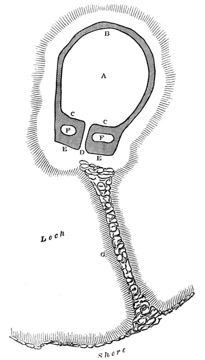
Fig. 244.—Defensive structure on an island in the Loch of Hogsetter, Whalsay, Shetland. (From a Sketch Plan by Dr. Arthur Mitchell.)
In the Loch of Hogsetter, in the island of Whalsay, in Shetland, there is a small island containing a defensive structure of dry-built masonry (Fig. 244) which is plainly not a Broch.[93] The structure occupies the greater part of the available surface of the island, and its form has evidently been determined by the form of the island. It consists of a dry-built wall of stones with a minimum thickness of 3 to 4 feet, enclosing an oblong oval of about 70 feet by 75 feet. A causeway, 33 yards in length, has been constructed to give access to the island from the shore, and on the side next the causeway the enclosing wall is amplified so as to admit of the construction of a doorway, flanked on each side by a 261chamber, as seen in the detached work protecting the entrance to the island of Clickamin. This part of the construction is solidly built, and the chambers, which are placed to right and left of the entrance passage, occupy the interior 262of a somewhat rectangular expansion of the wall, measuring about 20 feet by 12 feet, and now only about 8 feet high. When Low visited Whalsay in 1774, this part of the construction was 15 feet high, and the chambers and their entrances were quite entire. They were beehive roofed, the entrances going straight through the back wall from the enclosed area. The main entrance, which was 2½ feet wide and 4½ feet high, was covered by the masonry which joined the two sides of the construction over its lintels, and at about two-thirds of its length inwards there were checks for a door and the usual bar-holes on either side. Dr. Mitchell states that above the two lower chambers there appear to have been other two forming a second tier, but as Low did not observe them, and no trace of a stair or other access to the upper level now remains, it seems possible that they may have been chambers of construction, or merely vacancies left to lighten the weight on the roofs of the chambers below. Apart from the peculiarity of its chambers, which are unlike the guard-chambers of the Brochs in having their entrances opening to the enclosed space and not directly opening into the passage, this structure has more affinities with the stone cashels than with the Brochs. Like them it adapts its form to the space in which it is situated, and like them it consists of a simple rampart with cells in the thickness of the wall. The wall is low, and of no great strength, and like the wall of a cashel is merely meant to add to the defensibility of a naturally defensive position. The special peculiarities of this defensive construction are, that it is a dry-built structure which is not a Broch but a cashel, and that it is situated on an island in a loch and rendered accessible by a causeway. The island is of natural formation, and has been thus utilised, because of its suitability for defensive purposes.
Such instances of the adaptation of natural islands in 263lochs as places of strength by constructing defensive buildings of stone upon them are not uncommon, although it rarely happens that the form and characteristics of the buildings themselves are so clearly traceable. But there is another variety of defensive construction which is more frequently found in similar positions. It possesses the additional peculiarity of being either wholly or partially constructed of wood.
The Lake-Dwellings in Scotland, which are either wholly or partially constructed of wood, and which on that account are known as Crannogs, are very numerous, but so few of them have yet been systematically explored that it is impossible to determine with any degree of certainty the special characteristics of their typical form and structural arrangements. Indeed, it is questionable whether this knowledge may be in any measure attainable by investigation of their existing remains. Constructed of perishable material, which, as long as it survived the ravages of time, was capable of being adapted to many and various purposes of general utility, the parts of the Crannogs that stood above the water were almost certain to be gradually destroyed. But whatever may have been the special form of the superstructure of the Lake-Dwelling when it was built of timber instead of stone, the typical Crannog, taken as a whole, differs from the stone-built strengths that are placed in lakes not only in the substitution of timber in place of stone as the material of its construction, but also in being constructed usually on an island that is itself an artificial construction. The Crannog is therefore a Lake-Dwelling, actually built up from the lake-bottom. Of the structure which stood above the water, and gave shelter and habitable houseroom to the inmates, there is usually no trace whatever. Occasionally the remains of a pavement of timber or of flagstones, or the site of a hearth with its accumulations of ashes and food 264refuse marks the level of the floor, and sometimes a succession of such indications at different levels may betoken successive occupations. But the story of the Crannog as told by the casual relics imbedded in and around its submerged foundations is clearly intelligible, although it reveals nothing of the precise form and arrangements of the habitable part of the structure.
In the Loch of Dowalton, situated in the centre of the peninsula, bounded on the west by the Bay of Luce, and on the east by the Bay of Wigton, in Wigtonshire, a group of Crannogs was investigated by Earl Percy (then Lord Lovaine) in 1863, and subsequently examined by Sir William Maxwell of Monreith, and the late Dr. John Stuart, then Secretary of the Society of Antiquaries of Scotland. One of these, situated on the south side of the loch and near the west end, presented the appearance of a mass of stones and soil surrounded by numerous rows of piles formed of young oak-trees. On the north-east side of the island a number of beams of oak mortised together like hurdles were visible, and below them layers of round logs laid horizontally. A few vertical piles were observed, which, in some cases, had cross-beams mortised into them. Below the layers of logs were masses of brushwood and fern. The only sign of occupation noticed was the site of a hearth, with an accumulation of ashes, burnt wood, and bones of animals. In the adjacent refuse-heap a small fragment of bronze was discovered, and close by the island a bronze basin was found. Near the eastern margin of the loch was a group of three Crannogs. The largest of these was about 23 yards in diameter. It was surrounded by many rows of piles, some of which had their ends cut square across with a hatchet. The surface of the Crannog was covered with stones resting on a mass of brushwood, fern, and heather, intermingled with stones and earth. The whole mass was penetrated and kept 265together by piles driven through it into the bottom of the loch. On the south side were the remains of a massive construction of planks of roughly-squared oak, 5 feet long, 2 feet wide, and 2 inches thick, laid side by side in layers crossing each other transversely, and pinned together. The general framework of this platform-like structure was of massive beams mortised together, the mortises measuring about 10 inches by 8 inches. On the north-east side, and underneath part of the timber construction, a canoe was found, 21 feet in length and 3 feet 10 inches wide at the stern. The canoe was of oak, hollowed out of a single tree, and the stern was closed by a board sliding in a groove cut in both sides, and secured by a thicker piece 3 inches in height pegged down over it. A washboard projecting slightly over the edge and pegged into the upper margin of the canoe, ran all round the sides. Fig. 245.—Portion of a Shoe of stamped leather (length, 7 inches). There were two thole-pins inserted in square holes on each side, and one of the thwarts remained in position. A portion of a shoe formed of stamped leather (Fig. 245) was discovered among the mass of material thrown out in excavating the canoe. One hearth was discovered. It was simply a paved space, showing marks of fire and an accumulation of ashes and food refuse. The bones were those of the common domestic animals, the ox, the pig, and sheep. Among the 266relies found on the Crannog were a bronze penannular brooch with knobbed ends, the knobs somewhat quadrangular in form, two iron hammers, and four whetstones.
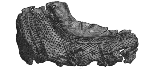
Fig. 245.—Portion of a Shoe of stamped leather (length, 7 inches).
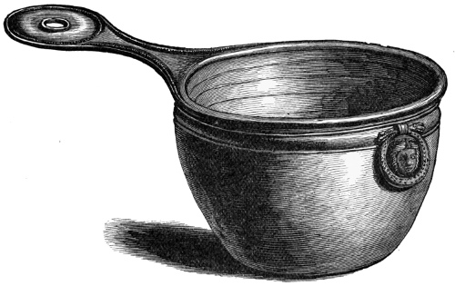
Fig. 246. Saucepan of Roman form found in Dowalton Loch (height, 5½ inches).
Another Crannog, nearly circular, and 13 yards in diameter, lay a little to the southward. Its construction was in every respect similar to that last described, and it was surrounded by an immense number of piles, extending in rows for 20 yards outside the circumference of a solid construction of brushwood and logs, covered by earth and stones. One canoe was found on its margin, 24 feet long and 4 feet 2 inches wide in the middle; and another was found between it and the shore of the loch, 18½ feet long and 2 feet 7 inches wide. Among the refuse of the occupancy of the Crannog, consisting chiefly of bones of domestic animals, were found a broken bead of glass, and portions of two armlets of glass, one ornamented with a yellow streak and the other with streaks of blue and white.
Between this Crannog and the shore a bronze saucepan (Fig. 246), of the form usually associated with remains of the 267Roman period,[94] was found in the mud of the loch. It is an elegant and well-finished vessel of bronze, tinned inside, and measuring 8 inches in diameter across the mouth and 5½ inches deep. The flattened handle springing from the upper edge is 7 inches in length. The bottom of the vessel is furnished exteriorly with five projecting concentric rings. In front, opposite to the handle, is an ornamental ring, swung by a loop projecting from beneath the upper margin of the rim, and encircling a well-modelled figure of a human face in relief. On the handle is the stamp of the maker, CIPI POLIBI F.[95]
About 60 yards from this last Crannog was a smaller one, presenting no essential points of difference, and nearer the south-east shore of the loch was a group of six, still smaller and less distinct in outline, but all apparently similar in construction.
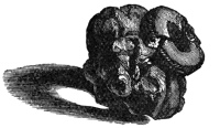
Fig. 247.—Bead of glass with lining of bronze (length, 1 inch).
The other objects found in association with these Crannogs or in the loch-bottom in their immediate neighbourhood, were a number of beads of variegated glass or vitreous paste, one of which (Fig. 247) has a lining of bronze in the perforation; one amber bead; a small bronze ring; a clay crucible; several whetstones; five querns; 268a bronze dish (Fig. 248), about 12 inches in diameter and 3 inches deep, hammered out of the solid, and having a flat rim 1 inch in breadth, turned over, and slightly bent downwards; another dish similarly made, but without the flattened rim, 12 inches diameter and 4 inches deep; and a third (Fig. 249) of thinner metal, flat-bottomed with sloping sides, 10 inches diameter and 4 inches deep, the bottom and sides patched in several places by pieces fastened on with flat-headed double-toed rivets exactly like the modern paper-fasteners; a large bronze ring attached to the upper part of a caldron of thin bronze; a portion of a tube of cast bronze of unknown use; a wooden paddle; and a number of fragments of articles of iron complete the list.
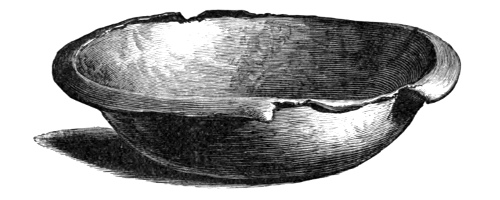
Fig. 248.—Bronze Basin found in the Loch of Dowalton (height, 3 inches).
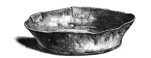
Fig. 249.—Basin of thin bronze found in the Loch of Dowalton (height, 4 inches).
In the Black Loch, in the parish of Inch, Wigtonshire, an 269island explored in 1872 by Mr. C. E. Dalrymple was found to have been a Crannog formed upon a shoal in the lake. In the centre of the island there was a circular mound, 45 feet in diameter, and rising to about 5 feet above the level of the loch and 3½ feet above the general surface of the island. At a depth of about 5 feet in the centre of the mound there was a flooring of trunks of trees, chiefly oak and alder, crossing each other at right angles. This log flooring covered a circular space of about 50 feet in diameter. At different levels above it and over the whole of its area there were found many fireplaces or hearths, formed of two long narrow slabs set on edge and parallel to each other with a paved space between, and filled and surrounded by ashes and bones of animals broken and split. In one of these accumulations of ashes and food refuse there were found a fragment of bronze and a portion of an iron knife; and in another a broken armlet of glass. A broken double-edged bone comb, ornamented with dots and circles, and a portion of a stone disc with a bevelled edge, were also found. The island seemed to have been surrounded with piles, and a small canoe, dug out of a single tree, was discovered in the loch, near the narrow channel which separates the island from the shore.
The general character of the group of relics obtained from these structures is that of the Iron Age, with indications of a period subsequent to the Roman conquest. The same character and the same indications are presented by the group of relics obtained from the Crannogs of Ayrshire, which have been so carefully investigated by Dr. Munro.[96] The Lochlee 270Crannog, near Tarbolton, yielded a very large collection of objects in the various materials of stone, bone, wood, bronze or brass, iron, glass, and jet or cannel coal. But with the single exception of a polished stone celt, the types of the Stone and Bronze Ages are entirely absent from the group. The same thing is true of the collections obtained from the Crannog at Lochspouts near Maybole, and the Buston Crannog near Kilmaurs. But in these Crannog collections there are certain groups of objects which are closely akin to those found in Brochs. These are the hammer-stones, oblong water-worn pebbles wasted at the ends by use, spindle-whorls and querns, the round polished discs of stone, the peculiarly-shaped bone pins, needles, and borers, the double-edged bone combs, the deer-horn implements, the bronze brooches, rings, and pins, and the spiral finger-rings. There are also certain objects in these collections which present features of form and ornamentation clearly of the early Celtic types, such as a bridle-bit from Lochlee (of the same form as that shown in Fig. 101), a block of ash-wood from the same Crannog with Celtic patterns cut in both sides, and a bronze mounting from Lochspouts, which is characteristically Celtic in style. On the other hand, there are certain objects which, like the harp-shaped fibulæ and the lustrous red ware (commonly called Samian), are indicative of post-Roman times. The bulk of the relics from the Crannogs being thus of Iron Age types with indications of post-Roman time, and with a striking general affinity to the group of relics obtained from the Brochs, the place of these lake-Dwellings in the general series may be considered as sufficiently established.[97]
271There is no class of ancient remains within our country of which we have less precise knowledge than the Hill-Forts. The reason of this is not their rarity, because they form perhaps the most numerous and widely-distributed class of ancient structures now existing. But the ordinary methods of obtaining precise knowledge of their form, structure, and contents have not been applied to them, and the ordinary agencies of destruction, incident to a high condition of social and agricultural progress, have long been busy amongst them.
They differ essentially from all other constructions, because they are adaptations of naturally elevated sites for defensive purposes. The natural site is the defensive position, and the fort itself derives its form and in many cases also its character of construction from the form and nature of the eminence or promontory on which it is built. It would, therefore, be contrary to the nature of the circumstances to expect that they should exhibit any such uniformity of plan or structure as is so conspicuous in the case of the Brochs. Yet it is clear, from the little we do know of them, that there are certain groups possessing certain features of construction in common which differ from other groups possessing other features of construction in common; and it is evident that if a sufficient body of available materials existed on record regarding the different members of these groups 272their typical characteristics might be readily deduced. But before this can be done with that precision and certainty which are requisite for scientific work, it is necessary (1) that a series of plans and sections to scale of a sufficient number of examples from each of the various groups should be obtained; (2) that a series of observations as to the methods of construction employed in different circumstances and situations should be made; and (3) that a series of examinations of the enclosed areas and surrounding ground should be undertaken, with the view of ascertaining the character of the relics that are associated with the structures. In the meantime it is only possible to indicate some of their general characteristics as exhibited by a few of the better known examples.
They naturally divide themselves into two great classes by their construction—(1) those that are earth-works; and (2) those that are constructed of stone.
In most cases the earth-works are so low and slight that they could not have been of much service unless crowned with palisades. They are usually on sites that are more susceptible of cultivation than the hill-tops which are the common positions of the stone-works, and hence they have suffered more generally from agricultural operations than the forts of stone. They are usually irregularly circular or oval in plan, consisting of a varying number of low embankments drawn round the summit of a natural eminence. The only one of which a scale-plan has been made is a very characteristic example (Fig. 250), on the Midhill Head, on the estate of Borthwick Hall, Midlothian.[98] The space enclosed by the embankments is 410 feet in length from east to west, and 284 feet in breadth from north to south. The embankments 273are four in number, occupying a space round the enclosure, varying from 130 feet to about 80 feet in breadth. They are nowhere more than from 4 to 5 feet in height. There are two entrances to the enclosed space at the ends of the oval, and a third on the south side. This example represents in a general way the class of earthworks of most frequent occurrence, consisting of a series of circumvallations enclosing the highest part of an eminence of no great elevation.
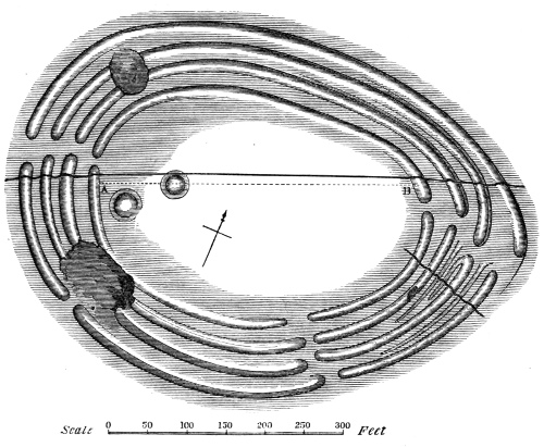
Fig. 250.—Ground plan of Earthwork on Midhill Head, Midlothian.
The Hill-Forts which are constructed of stone sometimes consist of a single wall drawn round the brow of a hill, and enclosing the more or less level area which forms its summit. One of this description at Garrywhoine, in Caithness, is an 274oval enclosure about 200 paces long by 65 in breadth. The foundation of the wall is about 14 feet thick, and in some places 3 or 4 feet of its height remains. In the thickness of the wall on the east side the remains of two chambers are visible. There were two entrances to the area of the fort, one at the north end and the other at the south end of the hill. The entrance at the north end has three of the great corner-stones of the gateway still in position. They are single stones or flat boulders about 5 feet high, set on end, having their broad faces in line with the exterior and interior faces of the wall, and the ends in the line of the entrance which is 7 feet wide. Only one of the stones similarly placed remains at the south entrance. The dilapidation of this remarkable example of a stone cashel was due to the construction of a mill-dam in the valley below, the stones having been rolled down the hill to form the embankment. I notice it because it is the only Hill-Fort I have seen which still retains the stone-pillars of its gateway, and because the story of its demolition illustrates the fate of many of the most perfect and interesting remains of our country’s antiquity.
A more complex variety consists of two, three, or more walls drawn concentrically round the upper part of a conical hill, at short distances apart, as in the case of the example known as the White Caterthun in the parish of Menmuir, Forfarshire. The area enclosed is a long oval about 450 by 200 feet. The enclosing wall has been of enormous size. Its remains have spread themselves over a width in some places of nearly 100 feet, and they now form a somewhat rounded embankment of from 4 to 6 feet high, encompassing the summit of the hill. About 150 feet lower down on the slope of the hill is another wall, equally ruined, and below it are the remains of a third. Beyond this there is an enclosure of an oblong form and of less massive construction, 275abutting against one side of the outer wall of the fort.[99] A fort of smaller size, but presenting somewhat similar features of construction, crowns the spur of Ben Ledi which overlooks the ford at Coilantogle, a little below the outlet of Loch Vennachar. The hill is precipitous on one side, and the walls do not encircle it completely, but the external faces of three encircling walls are in some places visible for a considerable distance round the less precipitous part of the hill. Abutting on the outer wall, on the side which is most accessible, is an oval enclosure less massively constructed, as at Caterthun.
There is another variety of these Hill-Forts which has attracted more attention on account of the singularity of the phenomena which they present. These are the Vitrified Forts, so called because in their walls there is always more or less of the scorified or vitrified appearance which is the result of the action of fire upon masses of loose stones. Although there has been perhaps more written about these singular structures than about any other class of antiquities, there is really little known of their special phenomena, and less of their real character.[100] In point of fact the real knowledge 276relating to the form, measurements, and composition of the structures and the observation of the phenomena they present has been entirely overlooked in fruitless discussions as to the modes in which the vitrifaction of the walls has been produced, and the reasons which may be conjecturally assigned for it. The result is that to this day, so far as I am aware, there is not a single scale-plan with sections, of a single one of them. When such plans and sectional drawings are available in sufficient numbers, we shall be able to say that the materials exist for the commencement of a systematic investigation of the nature and typical relations of the structures.
The fort on Knockfarril, which overlooks the valley of Strathpeffer, in Ross-shire, encloses an oval area of about 120 paces in length by about 40 in breadth. It was first described by Mr. John Williams in 1777.[101] Sections were then made through it from side to side, and Mr. Williams states that on the north side he found the ruins of the wall 12 feet high, although he came to the conclusion that this was a section of the width of the wall which had fallen flat outwards. With regard to the phenomena of vitrifaction, he states that the whole wall has been run together into one solid mass, but in another place he states that at the outskirts of the ruins and at the bottom of the hill there was a great quantity of large stones which had not been touched by fire, and from this he concluded that there had been some kind of stone buildings going round on the outside of the vitrified walls. It is to be observed that when he speaks of the whole wall being run together into one solid mass, he is not stating a fact, which he has observed, but a conclusion which he has formed from a partial examination. 277“I am of opinion,” he says, “and it appears by the ruins that the whole of the surrounding wall on Knockfarril has been run together by vitrifaction much better than the most of the kind I have seen.” He states also that immediately on the inside of the surrounding walls there were ruins of buildings in which the vitrifaction was much less complete, and these he imagined to have been a range of habitations reared under the shelter of the outer wall.
Craig Phadrig, near Inverness, when examined by Williams, presented the peculiarity of two vitrified walls, the remains of which could be traced quite round the inclosed area, while the remains of a third were visible at the entrance at the east end. The outer wall was founded on the rock, about 6 or 8 paces distant from the inner wall. Its greatest height did not then exceed 4 or 5 feet, but he found large masses of it adhering to the rock where it was first run. The area enclosed was from 80 to 90 paces long by about 30 broad.
The fort at Finhaven, near Aberlemno, in Forfarshire, is an irregular oblong with rounded corners, about 150 paces in length by about 36 in breadth. The walls are greatly dilapidated, and but a small part of their height is now visible. They appear to have been about 10 feet in thickness, and in some places there is still 4 or 5 feet of the height remaining. The vitrifaction is very unequal, and many parts of the wall scarcely show the action of fire, while in others the melted matter has run down among the interstices of the stones.
Dun Mac Uisneachan, in Loch Etive, was described by Dr. Maculloch in 1824, and more recently by Dr. R. Angus Smith, who made extensive investigations of the area of the fort in 1873-4.[102] It occupies the top of an oblong hill which is either 278very steep or actually precipitous on all sides. The area enclosed is about 250 yards long by 50 yards broad. It is encompassed on the verge of the hill by a wall which is still in some places from 5 to 6 feet high. The points made out by the investigation are thus stated by Dr. Angus Smith—(1) the weaker parts of the dun or defensible position were walled, the outer wall or part of wall being vitrified; (2) the wall of the western part is double; the outer being vitrified, the inner built in layers of flat stone, 9 feet being the distance from surface to surface; (3) the walls were built without mortar as in all these forts; (4) vitrified portions of walling were found overlying portions built in the ordinary manner and unvitrified. This I regard as the most interesting and important point ascertained by Dr. Angus Smith’s investigations regarding the construction of the so-called Vitrified Forts. It shows distinctly that the wall of a Vitrified Fort is not always, and in every part, a vitrified wall; and it suggests that instead of taking this for granted, in every case in which signs of vitrifaction are observed, the inquiry ought to be directed to the determination of the extent of such partial vitrifaction, wherever it is found to have been partial. Another interesting result of his researches was the discovery of the remains of dwellings within the area of the fort. They were rectangular constructions, having dry-built walls about 2 feet thick. A large refuse-heap of bones of the common domestic animals was found near them. Some querns, a portion of an iron sword, an iron ring about 2 inches diameter, and a convex plate of bronze 1¼ inch diameter, ornamented with concentric circles, the hollows of which were filled with red and the centre with yellow enamel, were found in the course of the excavations. The character of this relic, with its red and yellow enamels, is closely allied to that of the similarly enamelled bronzes which have been already described, some of which 279have been found in constructions of a very peculiar type which have yet to be noticed.
The latest examination of Vitrified Forts is contained in a paper by Dr. Edward Hamilton,[103] in which he gives detailed descriptions of two such structures in Arisaig, one of which is situated on a promontory in Loch na Nuagh. It is an irregular oval occupying the whole summit of the promontory, and measuring about 100 feet in length by about 50 feet in breadth. The enclosing wall varies from 6 feet in thickness and 7 feet in height to about 5 feet in thickness and 3 feet in height. In this case also the wall was not vitrified down to the foundation. Underneath the vitrified portion there was a depth of 3 feet of walling formed of water-worn boulders quite unvitrified. The internal part of the upper or vitrified portion of the wall was also unvitrified. From these appearances Dr. Hamilton concludes that the vitrifaction was the result of fire applied to the upper part of the wall externally.
From a consideration of these examples it is evident that the Vitrified Forts do not differ in any essential point of their character from the forts that are not vitrified—if vitrifaction be not a feature in the method of their construction. The results of former investigations have not produced evidence sufficient to carry the conclusion that the vitrifaction was accomplished at the time of their construction, or that it was a method of construction. The determination of this question lies at the end of an exhaustive investigation, and can only be obtained from evidence furnished by the phenomena of the structures themselves.
There is one fort in Scotland, at Burghead, in Morayshire, which presents the peculiar feature of being partially constructed of logs of oak alternating with layers of stones. The peculiarity of its dry-built stone rampart is thus described by Dr. Macdonald:—“To strengthen it, beams of 280solid oak (still measuring from 6 to 12 feet in length) take here and there the place of stones, and similar beams inserted end-ways pass into the mass behind.”[104] We only know the Vitrified Forts from their greatly dilapidated ruins, and it is a legitimate object of investigation whether any of them may yet present evidence of having been constructed with logs and stones in the manner exemplified at Burghead. This method of construction is characteristic of the Celtic or Gaulish forts of France. The rampart of Murcens, on the river Lot is constructed like that of Burghead, of unhewn and uncemented stones. In its mass, at regular intervals, there have been laid courses of oak logs disposed longitudinally and transversely as “binders” and “headers.” The spaces between the logs are filled with stones, and where they cross each other the transverse logs are fastened to the longitudinal rows by massive iron nails. There are two rows of logs laid parallel to the face of the wall and a little apart within its thickness, and these are crossed at every 3 or 4 feet by logs lying transversely and extending the whole thickness of the wall, so that their opposite ends appear in its exterior and interior faces. This is repeated at every 3 or 4 feet of the height of the wall. The same method of construction, with a greater proportion of timber to the mass of the wall, appears in the fort of Impernal, also on the river Lot.[105] It is obvious that by the application of fire to ramparts constructed on this principle, a partially scorified and partially vitrified appearance would be given to their ruins.[106] In the early annals the burning of fortified 281places appears as the common method of reducing them, and the legendary prophecy of the coming of Birnam Wood to Dunsinnane possessed a peculiarly fateful meaning if its walls were built not of stones alone but of stones and logs.

Fig. 251.—Section of Hill-Fort of Dunsinnane, showing underground chambers within its area. (Not to scale.)
The Hill-Fort of Dunsinnane (a section of which is shown in Fig. 251) is an oval circumvallation crowning the summit of a conical hill, some 800 feet in height. The rampart is now chiefly composed of earth intermixed with boulders, and is in some places about 20 feet wide at the base, rising to a height of from 6 to 8 feet. Fragments of vitrified matter, cementing masses of small stones together, are found in the rampart. The space enclosed is about 150 yards long by 70 yards wide and almost level. Towards its south-east side 282were two underground chambers 20 feet in length, from 6 to 8 feet in width, and 5 to 6 feet high. The chambers communicated with each other, near their extremities, by two passages low and narrow, not much exceeding 2 feet in width and 3 feet high. The floors of the chambers were paved with rough slabs. The walls were built with undressed stones, which at the height of 2 to 3 feet above the floor began to converge until the roof was spanned by flagstones laid across. The floors were covered with ashes and refuse, consisting chiefly of the bones of horses and cattle, and horns of deer. A quern was found by the side of one of the passages, and in another were parts of three human skeletons. Near the entrance to the circumvallation a bronze spiral finger-ring, described as of exquisite workmanship and formed like a serpent, was found.[107]
Dunsinnane is the only Scottish hill-fort associated with underground chambers. But there is a class of underground structures of peculiar form which is common in Scotland, though unconnected with any variety of defensive structure. They are mostly situated in arable land now under cultivation, and have usually been discovered by the plough coming in contact with the stones of the roof.
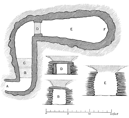
Fig. 252.—Ground plan and sections of Earth-house at Broomhouse, parish of Edrom, Berwickshire.
One was so discovered at Broomhouse in the parish of Edrom, Berwickshire. It had been known before and most of the roofing stones removed, but on this occasion it came under the observation of Mr. Milne-Home, who communicated an account of it to the Society of Antiquaries.[108] It is to such casual circumstances that we owe the materials of our science. The structure presents the form (shown in the ground plan, Fig. 252) of a long narrow gallery, entering by a low and narrow aperture nearly on a level with the surface, widening and deepening from the entrance inwards, turning 283first sharply to the left and then to the right, and terminating in a closed and rounded end. The opening (A) faced nearly to the south-east. The whole length of the gallery, measured along the central line of the floor, was 30 feet, its width at the entrance 2 feet, and at the widest part 6 feet. Only three of the roofing stones (B,C,D) remained in position. The vertical height of the walls at the widest part of the structure was 5 feet, and under the roofing stone (B) next the entrance only 3 feet. It seemed as if the floor had been paved with natural water-worn stones, but this point was not clearly ascertained. At the second bend (D) there are checks for a door, consisting of two oblong stones set on end and still carrying 284a massive lintel. The side walls, from the entrance inwards to this inner door, are vertical. In the wider part of the structure (E) beyond the inner door they are brought towards each other by the stones overlapping inwardly, so that the roof might be covered by single slabs laid across. Nothing was found within it but fragments of bones of animals, among which the roe-deer was the only one that could be certainly determined.
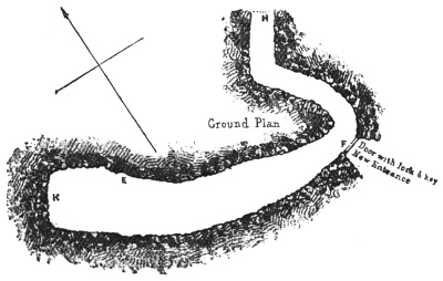
Fig. 253.—Ground plan of Earth-house at Migvie, Aberdeenshire. (From a plan by Mr. Jervise.)
At Migvie, in Aberdeenshire, an underground structure (Fig. 253) was discovered in 1862.[109] It was situated in the summit of a gravel hillock, and was in form a long, low, and narrow gallery, entering by an aperture nearly on the level of the original surface, turning first sharply to the left and then to the right, widening and deepening from the entrance inwards and terminating in a squarish end slightly rounded at the corners. The whole length of the gallery measured along the curvature was 41 feet, the width at the entrance 2 feet, and at the widest part about 5 feet. Nine stones covering the portion next the entrance remained in position, the height of the gallery under them increasing from about 2852½ feet at the aperture to 4½ feet at the place where the covering ceased. The vertical height of the walls beyond this seemed to have been at least 5 feet. The side-walls were built with rough boulder stones laid pretty regularly. When the interior was cleared out the only objects found were a bronze ring, several rude stone-vessels like roughly-formed cups, large quantities of ashes and charred wood, and corroded fragments of iron implements.
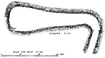
Fig. 254.—Ground plan of Earth-house at Buchaam, in Strathdon.
The similarity of these two structures is no less striking than the excessive peculiarity of their distinctive features. These features are—(1) their position under ground; (2) the contracted entrance; (3) the form of the chamber—a long, low, narrow, and curved gallery gradually widening inwards; and (4) the construction of the chamber—with convergent side-walls supporting a heavily-lintelled roof.
Closely analogous to these in its main features is the underground structure (Fig. 254) at Buchaam, in Strathdon.[110] It is along narrow gallery entering by a small aperture in the narrow end nearly on a level with the original surface of the ground, gradually widening and increasing in height inwards, 286and terminating abruptly in a slightly-rounded end. It differs in one respect from the two previously described, inasmuch as though it is curved it has not the double curvature which is the special feature of their form. It curves sharply to the left, but the curvature is not repeated in the opposite direction. It is 58 feet in length following the curve along the middle line of the floor. Its width at the entrance is 3 feet 6 inches, and it gradually widens until it attains a maximum breadth of 9 feet 3 inches. The height increases from about 5 feet near the entrance to about 7 feet at the farther end. The roofing stones were mostly in position and were of great size, some being 7 to 8 feet in length, 3 feet in width, 18 inches in thickness, and weighing more than a ton. The walls rise perpendicularly for 2 or 3 feet and then incline inwards with a curve, so that where the width of the chamber at the floor is 9 feet 3 inches, it is contracted to 7 feet 9 inches at 4 feet above the floor and at the roof to 5 feet. The walls are well built, the lower courses of large cubical stones, undressed, and at the distance of about 12 feet inwards from the entrance there are checks for a door formed of two oblong stones set edgeways in the wall and projecting a few inches from its interior surface. The whole floor of the chamber was paved, and a drain, 10 inches square, well built with a good roof, sides, and bottom, and having a peculiar box-like opening or sink in the inside of the chamber, was found leading from its south-east corner. The chamber when opened was nearly filled with earth and rubbish, and at the bottom there was a layer of fine blue clay 20 inches in depth, which had been carried through the walls by percolation of water from the clay bank outside. In or below this clay which covered the paved floor were found the following relics of human occupation—an iron ring, and an object in iron which looked like the shoe of a wooden spade, some staves of a small wooden cog, a wooden 287comb, some fragments of pottery of coarse workmanship, a portion of a quern or handmill for grinding grain, fragments of deer’s horns, and bones of the sheep and common domestic fowls. At one corner of the inner end of the chamber the ashes of a fire remained, and immediately above them there was a well-built smoke-hole.
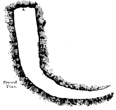
Fig. 255.—Ground plan of Earth-house at Culsh, parish of Tarland. (From a plan by Mr. Jervise.)
A similar structure (Fig. 255) at Culsh, in the parish of Tarland in the same county, differs from this one only in being curved to the right instead of to the left. It is 47 feet in length and 2 feet wide at the entrance, the width increasing gradually to about 6 feet at the farther end. The walls are partially formed of large boulders set on end or on edge to form the lower course, with rudely-built masonry over them. They converge but slightly, and the roof is formed in the usual manner by large heavy slabs laid across from wall to wall. The floor is formed of the natural underlying rock, and the height from floor to roof increases from 5 feet near the entrance to an average of about 6 feet farther in. When 288cleared out in 1853, the earth which filled the chamber was found largely mixed with ashes on the floor, and the only relics obtained from its excavation were fragments of coarse unglazed pottery, a large bead, the bones of cattle, and two querns.
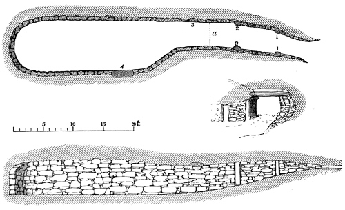
Fig. 256.—Ground plan and sections of Earth-house at Kildrummy, Aberdeenshire. (From a Plan by Mr. Lumsden of Clova.)]
Another (Fig. 256) excavated a few years ago at Clova, near Kildrummy, also in Aberdeenshire,[111] differs from these in being so slightly curved to the left as to be almost straight. It measures 57 feet in length, 2½ feet wide at the entrance, suddenly widening to about 8 feet at about 20 feet within the entrance. At a short distance from the entrance there were checks for two doors about 8 feet apart. The covering stones had been removed from the first 15 feet of the narrow part, but the roof remained entire over the whole of the wider part of the structure, at an average height of about 6 feet from the floor. The earth with which the chamber was filled was largely mixed with charcoal and bones of animals, 289among which those of the horse and dog were recognised. No manufactured relics were found, but two of the stones in the walls, one being a large boulder, were covered with the small hemispherical pits known as cup-markings.
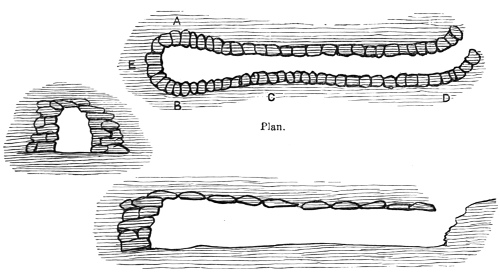
Fig. 257.—Ground plan and section of Earth-house at Eriboll, Sutherlandshire. (From a Plan by Dr. Arthur Mitchell.)
An Earth-house at Eriboll, in Sutherlandshire[112] (Fig. 257), resembles that at Clova in presenting so little curvature as to be almost straight. The curvature which it has is to the left, and only extends for a few feet within the entrance. It is said, however, to have been 10 or 12 feet longer than it was when examined in 1865. It was then 33 feet in length. It is peculiar for the smallness of its size, being nowhere more than 4½ feet in height, and for the greater part of its length only 2 feet wide, expanding to 3½ for about 3 feet only from the inner end. In view of this feature of its character, Dr Mitchell remarks that it is exceedingly difficult to see what purpose such a structure could have served; but he adds that it is worthy of note that in this district similar underground constructions are not rare, and that they are 290called by a Gaelic name which signifies Hiding-beds. The use of such underground places of concealment is referred to in the Saga of Gisli the Soursop, which relates to events occurring between the years 930 and 980, and was written in Iceland about the beginning of the twelfth century. It states that when Gisli was outlawed and every man’s hand was against him, he went to Thorgerda in Vadil “She was often wont to harbour outlaws, and she had an underground room. One end of it opened on the river-bank and the other below her hall.” Again it states that “Gisli was always in his earth-house when strangers came to the isle.”[113] The form of Earth-house thus described as then in use for concealment in Iceland is not the form of the Earth-houses found in Scotland, which have rarely two openings, but the passage is interesting because it shows that the traditional use ascribed to the Scottish examples is a use which was practised among a people who had close relations with the district in which the tradition still remains attached to these structures.
But whatever may have been the actual purpose or purposes to which they were applied, the fact which is of importance in our investigation is that these Earth-houses, though ranging in area from Berwickshire to the north coast of Sutherland, are all of one special character, long, low, narrow galleries, always possessing a certain amount of curvature, sometimes greatly, and at other times doubly curved, always widening and increasing in height from the low and narrow entrance inwards, usually built with convergent walls and roofed with heavy lintels, which are always lower than the surrounding level of the ground, so that the whole structure is subterranean. Occasionally they present variations in structure as in the case of one at Murroes, in Forfarshire, which, instead of being built, has its walls constructed 291entirely of flagstones set on edge. Similarly, the 292example at Kinord, in Aberdeenshire (Fig. 258), has its walls constructed of single boulders set on edge or on end, and it presents the further peculiarity of the chamber being divided into two branches at the farther end. One at Pirnie, in the parish of Wemyss, in Fife, and another at Elie, had steps leading down to the entrance.
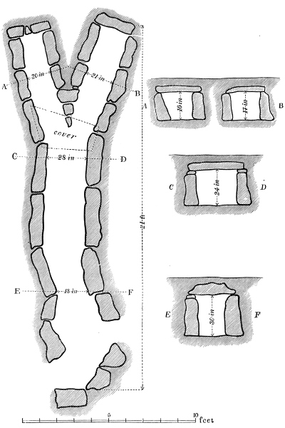
Fig. 258.—Ground plan and sections of Earth-house at Kinord, Aberdeenshire.
Occasionally they occur in considerable groups, as at Airlie, in Forfarshire, where there is a group of five. One of these is of great size, its length being 67 feet, and its average breadth, from the farther end to within about 12 feet of the entrance, 7½ feet. The height at the entrance is only about 22 inches, and the floor slopes down for about 20 feet till a height of about 6 feet is obtained. The walls are built of rough undressed boulders laid in pretty regular courses, and they converge from a width on the floor of a little over 7 feet to about 4 feet at the roof. The covering stones are of great size, many of them 7 or 8 feet in length and 4 feet wide. It contained the usual traces of cookery in the accumulation of ashes and bones of animals upon the floor. The only other relics found in it were a brass pin, a stone mortar-like vessel, and fragments of querns. The other four examples in the same neighbourhood are known to have existed, but have neither been measured nor described.
A still more remarkable group was brought under the notice of the Society in 1816 by Professor Stuart of Aberdeen. They are spread over a space of a mile or two in diameter on what was then a dry moor in the parishes of Auchindoir and Kildrummy, in Aberdeenshire. These excavated houses, he says, are most frequently discovered by the plough striking against some of the large stones which form the roof. The only opening to them appears to have been between two large stones placed in a sloping direction at one end, and about 18 inches asunder. Through this narrow opening one must slide down to the depth of 5 or 6 feet, 293when he comes to a vault generally about 6 feet high, upwards of 30 feet long, and 8 or 9 feet wide. The floor is smooth, as if of clay, and the sides are built of rude undressed stones without cement. The walls bend inwards to form a rude arch, and the roof is covered with large stones 5 or 6 feet long, some of them being over a ton in weight. The whole structure is beneath the level of the ground and quite invisible, but many of them were detected by the existence close to them of a square space about 10 to 15 paces each way dug a foot or two deep with the earth thrown outwards. These he conjectures to have been the sites of the summer huts of the people, who retreated to these underground places in winter, and stored their provisions and concealed their valuables in them all the year round. But he adds that no article of furniture, and no utensils or instruments either of stone or metal have been found in them so far as can be learned, but only a quantity of wood-ashes and charcoal, chiefly at the farther end, where there sometimes appears a small aperture at the top as an outlet for the smoke. The whole number discovered in this locality he estimates at between forty and fifty. They are found, he says, in other localities, but so great a number collected in one place has probably never before occurred. The number is certainly very large, and may probably be over estimated, but it would not be difficult to find in other parts of Scotland, and specially in Aberdeenshire, a series of groups of similar structures which, though not so numerous or so closely aggregated, are so distributed over wide districts as to show that the custom of constructing these underground edifices was general and prevalent. Wherever they occur they present the same individuality of character and the same strongly marked typical features. Their range in area extends from Berwickshire to Shetland. They occur in greater or less abundance in most of the counties bordering on the east 294coast. A few doubtful examples only are recorded in those bordering on the west coast. But it is only of late years that the importance of securing a permanent and exhaustive record of such casual discoveries has begun to be recognised, and in this direction of defining the areas of the respective types of structural antiquities, we are still groping in darkness on the threshold of a great investigation.
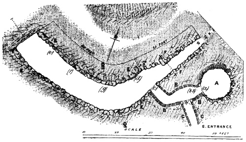
Fig. 259.—Ground plan of Earth-house at Cairn Conan, near Arbroath, Forfarshire. (From a Plan by Andrew Jervise.)]
I now proceed to notice a few examples which, by their associations or their contents, disclose indications of the period of the type.
In the spring of 1859 an underground structure of this type (Fig. 259) was discovered on the farm of West Grange of Conan, near Arbroath, Forfarshire. It occupies an elevated situation on the south-east slope of an eminence commanding an extensive view. The structure differs from all those that have been described, inasmuch as in addition to the long, low, narrow, and curved gallery widening and 295increasing in height from the entrance inwards, which is the typical form, it presents the additional feature of a circular chamber (A) attached to the long curved chamber near the narrow end, and also communicating with the surface by a passage (C C), thus giving to the composite structure a second entrance. The main chamber or gallery is 65 feet in length along the curvature of the central line of the floor. Its entrance is 2½ feet wide, and apparently little more than 18 inches high. It widens but slightly, till at a distance of 20 feet from the entrance there is an offset formed by a large stone set at right angles to the passage, beyond which it widens more rapidly to about 8½ feet across at the farther end. The walls are built of undressed stones, but in some places they are partially cut out of the soft rock, which, for a considerable portion of its length, also forms the floor of the chamber. The circular chamber (A) is about 10 feet in diameter and 7½ feet high. The floor is partly excavated in the underlying rock. The walls are rudely built of undressed boulders. They converge almost from the floor, and the covering stone was a large boulder resting on the circular apex of the vaulted roof which impeded the plough and thus led to the discovery of the structure.
About 20 feet to the north of the underground chamber there was a circular space from which the soil had been removed. It was rudely laid with a pavement of undressed flags forming a circular floor a few inches below the level of the surrounding soil, and about 20 feet in diameter. Among the flags of this paved space there were found a portion of a plain bronze ring about 3 inches diameter, the upper stone of a quern or hand-millstone, two whorls of lead, a number of rudely-hollowed stone vessels of various sizes, and fragments of implements in iron so greatly corroded as to be unrecognisable except as fragments of implements with cutting edges.
The articles found in the underground chambers were 296few in number. They consisted of some fragments of pottery, coarse, but wheel-made, pale yellow in colour, and differing in texture and manufacture from the usual handmade pottery of native origin found in many of the other structures of the same class. It closely resembles some varieties of pottery that are constantly found in the vicinity of Roman stations in Scotland. A bronze needle and a portion of a quern were the only other objects found. But that the place had been long occupied was sufficiently apparent from the quantity of ashes mixed with calcined and broken bones of the common domestic animals which it contained.
In this case we have distinct evidence of an underground chamber associated with an overground habitation of less permanent structure, of which time and cultivation had removed all traces except the circular paved floor and the casual relics which it contained. There can be no doubt that the people who occupied this overground habitation also possessed the underground structure, and used it for purposes connected with their daily life. There is little now left to disclose what the manner of that life was, but that little is highly significant. It discloses that they were a people cultivating grain and rearing cattle and sheep. They had utensils of stone it is true, and these of the very rudest form and fabrication, but they also possessed wheel-made pottery and weapons or implements of bronze, iron, and lead.
A singular interest attaches to this little settlement, inasmuch as it not only shows us the association of the two forms of underground and overground structure which united to make one habitation, but also gives the associated grave-ground of the family. A few yards distant from the dwelling there was a group of six graves. They were full-length, stone-lined graves, rudely constructed, with three or four flattish slabs forming the sides, and one stone placed for 297each end. They lay so near the surface that the covering stones had mostly been removed by the plough, and the remains in them were greatly decayed. The only manufactured object found in them was a single ring or child’s bracelet of cannel coal. This is the only instance on record of the discovery of a cemetery associated with the double dwelling of the people who constructed these subterranean galleries.
Among the rubbish thrown out in the course of the excavation there was found a beautiful spiral bronze bracelet of the form of a double serpent, decorated in that peculiar style of art which has been described in the third Lecture of this course as the precursor or earlier development of the art of the Celtic Christian time.[114] Here we find the earlier art associated with this peculiar type of structure, and with a manner of sepulture which is destitute of all indications of Christianity. It is associated also with wheel-made pottery of a type that is only found in situations suggestive of Roman intercourse, and therefore indicates a period when Christianity had not yet supplanted the Paganism of the country. It was also in a precisely similar association with one of these underground structures that the massive bronze armlets (Figs. 115, 116), described in the same Lecture, were discovered at Castle Newe. They also are decorated in this peculiar style of art and enriched with enamels. Their workmanship evinces skill and taste of a very high order, and the occurrence of these works of art in such associations may serve to remind us how greatly we should have erred if we had estimated the capacity and culture of the inhabitants of these structures by their architectural character alone, or if we had measured their condition and acquirements merely by the fact that they burrowed under ground.
298
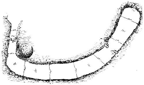
Fig. 260.—Ground plan of Earth-house at Tealing, Forfarshire. (From a Plan by Andrew Jervise.)
Another structure of the same type (Fig. 260), but of larger dimensions, was discovered in 1871 in a field at Tealing. It was 80 feet in length measured along the curve, 3 feet wide at the entrance and widening gradually to 8½ feet at the inner end, where it is a little more than 6 feet high. It has checks for a door at a little distance within the entrance, and a second pair about 16 feet from the farther end. The usual evidences of occupation were found in the presence of ashes, charcoal, and animal bones throughout the excavation. The manufactured relics unfortunately have neither been described nor figured, although they constitute the largest and most varied collection of objects ever obtained from such a structure. They are enumerated by Mr. Jervise as follows:—A piece of the red lustrous ware commonly called Samian, a bracelet, bronze rings, and coarse pottery, no fewer than ten querns, a number of whorls and stone cups, and an article made of iron slightly mixed with brass. The occurrence of the red lustrous ware in these Earth-houses, as well as in the Brochs and Crannogs, is an indication 299of the period of the occupation of these structures which is of great significance. The large size of the gallery, in the present instance, and the occurrence in it of ten querns, indicate that it was frequented by a considerable number of people. It has another feature of interest in the presence, on one of the rude boulders which form the walls, of a number of cup-markings, one of which is surrounded by five concentric circles. Another stone with forty-six cup-markings on it lay on the margin of a circular paved space close to the entrance of the structure. These cup-markings form one of the enigmas of archæology. They are shallow pits, roughly hemispherical in form, hollowed by pointed tools in the surfaces of rocks, boulders, and standing stones. Sometimes they are on vertical surfaces, sometimes on horizontal surfaces, occasionally on the under surfaces of stones placed as the covers of cists. Most frequently the cups are simple rounded hollows, but very frequently they are surrounded by a series of concentric circles of varying number, and often a straight gutter proceeds from the central cup through the circles. They are sometimes hewn in groups upon the solid rock of a hillside, sometimes on earth-fast boulders, occasionally on the stones of stone circles, and often on stones in sepulchral cairns or in connection with cists. They are not confined to Scotland, or even to Britain. They are found in Scandinavia, in France, in Germany, and Switzerland. They appear on the Continent in associations which refer them to the Bronze Age at least, but they also occur in associations which show that the custom survived to the late Iron Age, and even in a modified form to Christian times. Their occurrence here, in connection with this underground structure, has therefore no special significance with respect to the age of the structure, and there is nothing in the association or the circumstances in which they occur in this particular instance which contributes to our knowledge of 300the purpose or significance of the markings themselves. They may or may not have been sculptured on the stone before it was taken to form part of this underground gallery, and the only thing they tell us for certain is that here, at some time or other, there was a custom of which traces are found scattered over a wide area of Western Europe.
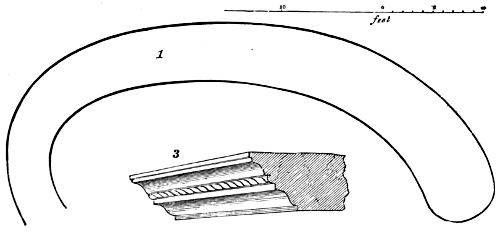
Fig. 261.—Sketch ground plan of Earth-house at Newstead, and stone with Roman moulding found in it.
But other indications have been found in connection with the structure and contents of these singular buildings, which carry the period of their construction close up to the time of the Roman occupation of the southern portion of Scotland. An underground structure of this special type (Fig. 261) was discovered near the village of Newstead, in Roxburghshire, in 1845.[115] It fortunately came under the observation of Dr. John Alexander Smith, who has given a carefully prepared notice of its peculiarities in the Proceedings of the Society. It was of the usual form, a long, low, and narrow gallery turning sharply to the right and widening and gradually increasing in height from the entrance. It measured 54 feet in length along the curve of the central line of the floor, and 301widened gradually from 4 feet at the narrow end to 7 feet at the farther end. The height was not ascertainable, as the roofing stones were gone, and scarcely more than 3 feet of the height of the side walls remained. But the walls presented the peculiarity of being built with hewn stones, laid in pretty regular courses, though not jointed with mortar or any other cement. Among the fallen stones in the interior of the structure there were many flat slabs bevelled on one edge, and two measuring about 4 feet in length which presented a rope-moulding (Fig. 261) of distinctively Roman character. No relics were obtained from the excavation of the building, but the character of the squared and bevelled stones and the presence of the Roman moulding indicate that the construction of the underground structure was subsequent to the period of the Roman occupation of that part of the country. Another structure of similar character was 302found in an adjoining field, but not built with squared stones. In all probability the squared stones of the one structure were due to the presence in its immediate neighbourhood of some Roman construction, the stones of which were utilised by the underground builders.
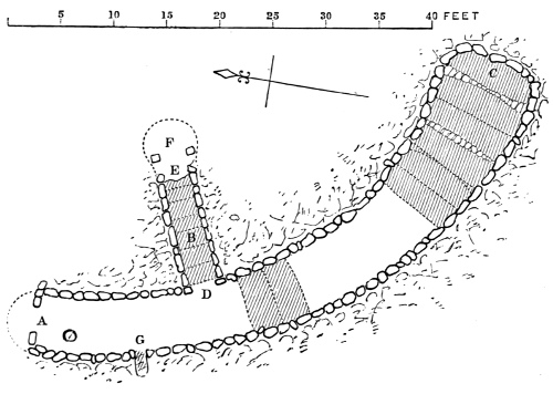
Fig. 262.—Ground plan of Earth-house at Crichton Mains, Midlothian.
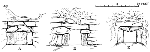
Fig. 263.—Sections of Earth-house at A, D, and E on ground plan.
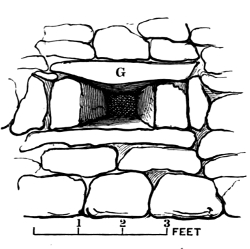
Fig. 264.—Ambry in Earth-house at Crichton Mains.
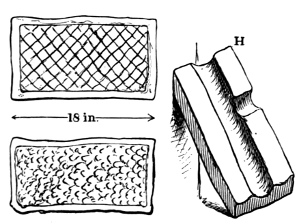
Fig. 265.—Stones in Earth-house at Crichton Mains.
Another structure of the same type (Fig. 262) was found in 1869 at Crichton Mains, in Midlothian.[116] It was of the usual long, narrow, curved form, 51½ feet in length, and gradually widening from 5 feet 10 inches just within the entrance to 9 feet at the farther end. A number of the roof-stones remained in position, and the floor throughout being formed of the natural rock it was seen that the average height was about 6 feet. The walls converge from the floor for about half their height and rise somewhat perpendicularly above that, thus giving to the cross-section the form of an ogee vault. The door (A, in Figs. 262, 263), formed of two upright stones crossed by a lintel, is 3 feet high by 33 inches wide, and the top is about 5 feet under the present surface of Fig. 264.—Ambry in Earth-house at Crichton Mains. the ground. Fourteen feet inwards is a passage at right angles to the gallery, the entrance to which is shown at F in Fig. 262. It is 13 feet long, 3 feet wide, and 3 feet 6 inches high, rising by low sloping steps in the rock to what seems 303another entrance nearer the surface, also shown in Fig. 262 at E. At G is a small ambry (Fig. 264). No relics were found in the excavation; but here and there in the interior faces of the walls there were a number of squared stones faced with the diagonal broaching and stugging which is so common in late Roman work.[117] About thirty of these are visible. Two are shown in Fig. 265. There were also other hewn stones, some of which had apparently formed portions of water conduits (H, Fig. 265), and others adapted to different Fig. 265.—Stones in Earth-house at Crichton Mains. purposes. The lintel-stone of the door of the side passage is moulded and bevelled on the edge in a similar way to the bevelled stones found in the structure at Newstead. It seems evident that this underground building, like that at Newstead, has been partially constructed with stones taken from a ruined building of late Roman workmanship, and that both are consequently later than the commencement of the Roman occupation of the country. Similar 304indications are given by the discovery of wheel-made pottery of Roman type in the Earth-house at Cairn Conan, and of fragments of the red lustrous ware commonly called Samian in the Earth-houses at Tealing, Pitcur, and Fithie. The presence in most of them of querns and implements of iron, and the entire absence of such implements as are characteristic of the ages of stone and bronze, are indications pointing to the same conclusion. On the other hand there is a complete absence of indications of Christianity, and the characteristics of the ornamentation of the bronze armlets found in association with them are those which belong only to the earlier and partial development of Celtic art, which preceded its subsequent and complete development under the new impulses and opportunities afforded by Christianity. It seems therefore that, so far as our present knowledge will carry us towards a definite conclusion, the period of this peculiar type of structure will lie between the time of the general establishment of Christianity and the departure of the Romans from Scotland.
The range of the type includes the whole eastern area of Scotland, stretching from Berwickshire on the south to the Shetland Isles. Its special form is so peculiar that it must be held to constitute a distinction sufficiently characteristic to separate the Scottish group from all other varieties of underground structures, and sufficiently constant to warrant us in assigning to it a specific value. There is an Irish group and a Cornish group of underground structures, but they do not generally present the special features of form which characterise the Scottish group. The Irish examples are usually associated with raths, thus resembling the specimen in the rath of Dunsinnane, which is the only one known of that special variety in Scotland. They are excavated in the area enclosed by the interior rampart of the rath, and consist of one or more chambers, sometimes circular 305or oval in plan but often rectangular, and connected together by low narrow passages. Sometimes the chambers are lined with masonry, and roofed by overlapping courses forming a rude dome-shaped vault; at other times they are simply excavated in the hard earth, while the passages and doorways are lined with stones. They thus differ considerably in form from the Scottish variety, and they differ also in being usually associated with raths or earthworks, while the Scottish structures are usually contiguous to the sites of overground habitations.
The general features of the Cornish group, on the other hand, are more allied to those of the Scottish area, inasmuch as they are often associated with clusters of overground habitations. One at Chapel Euny, in the parish of Saucreed, near Penzance, contiguous to the sites of four circular huts, is an underground gallery presenting features of remarkable similarity to that at Cairn Conan, in Forfarshire. The gallery, which is slightly curved, is about 60 feet in length, 6 feet wide, and from 6 to 7 feet high. A circular chamber, 16 feet in diameter, constructed of large granite blocks, each overlapping the one below it and thus forming a domed roof which must have been 10 or 12 feet high, was connected with the wider end of the gallery by a passage 10 feet long, opening off one side. Another small offset near the narrower end of the gallery, also about 10 feet long, slopes up to the surface, presenting an entrance doorway 2 feet 8 inches in height, with recesses on either side as if to retain a slab to close the doorway. The floors of the gallery and chamber were paved with flat stones, and provided with drains underneath the pavement. The relics found in the structure were whetstones; hammer-stones; spindle-whorls; several varieties of domestic pottery, red and black, mostly plain, but occasionally ornamented with markings made by a pointed instrument; an iron spear-head; and a fragment of the 306red lustrous ware commonly called Samian.[118] Another at Halligey, near Trelowarren, consists of a slightly-curved gallery 90 feet in length, from 3 to 5 feet in width, and about 6 feet high in the middle, becoming lower towards the extremities. It has a small rectangular chamber off one side at the farther end of the main gallery. The main gallery opens off the middle of the side of a shorter and wider gallery 28 feet in length, 5½ feet wide, and 6 feet high. At one end of this shorter gallery a narrow passage rises to the surface. The entrance passage is provided with checks for two doors, and the whole structure is strongly and substantially built and lintelled with large flags. On the surface there are traces of two embankments with an intervening ditch surrounding a large area within which there may have been a cluster of overground structures.[119]
Like the Scottish examples the Earth-houses of Cornwall are long narrow galleries of dry-built masonry, but they are not so strongly marked by the peculiar feature of single or double curvature which distinguishes the Scottish group. They are comparatively few in number, and any indications of the period of their occupation that have been observed point also to a time not far distant from the close of the Roman occupation of the country. No other group of such underground structures is known in any other part of Europe, or indeed anywhere else in the world. These excavated chambers, possessing the characteristics which have been described, are peculiar to the Celtic area, and the specially 307typical form with the strongly marked curvature is found only in Scotland.
Of the culture and civilisation of the people who constructed these strange subterranean cells, it may be impossible in the present condition of our knowledge to form an adequate estimate. But we can say this of them with certainty, that whatever may have been the special motives and circumstances that induced them to give this peculiar expression to their architectural efforts, they exhibit in other respects evidences of culture which, though it may be held to be inferior in range and quality to the culture of the Christian time, compares not unfavourably (so far as it goes) with that which is exhibited in connection with the superior architecture of the Brochs.
And while on all these lines of investigation we have traced the manifestations of these early forms of culture and civilisation up to points at which they seem to touch the culture and civilisation of the Roman Empire, it is to be observed that they do no more than touch it—they are not merged in it. In all their distinctive features they are still Celtic, and Celtic exclusively. There is nothing Roman in the forms of the prevailing types; there is nothing Roman in the art that decorates these forms; there is nothing Roman in the typical character of the structures in which they are found. The forms, the art, and the architecture are those of Scotland’s Iron Age—the Pagan Period of her Celtic people.
309