DAM ACROSS THE OTTAWA RIVER AND NEW CANAL AT CARILLON QUE
Reading edition
By ANDREW BELL Resident Engineer
The natural navigation of the Ottawa River from the head of the Island of Montreal to Ottawa City--a distance of nearly a hundred miles--is interrupted between the villages of Carillon and Grenville which are thirteen miles apart by three rapids, known as the Carillon, Chûte à Blondeau, and Longue Sault Rapids, which are in that order from east to west. The Carillon Rapid is two miles long and has, or had, a fall of 10 feet the Chûte à Blondeau a quarter of a mile with a fall of 4 feet and the Longue Sault six miles and a fall of 46 feet. Between the Carillon and Chûte à Blondeau there is or was a slack water reach of three and a half miles, and between the latter and the foot of the Longue Sault a similar reach of one and a quarter miles.
Small canals limited in capacity to the smaller locks on them which were only 109 feet long 19 feet wide, and 5 to 6 feet of water on the sills, were built by the Imperial Government as a military work around each of the rapids. They were begun in 1819 and completed about 1832. They were transferred to the Canadian Government in 1856. They are built on the north shore of the river, and each canal is about the length of the rapid it surmounts.
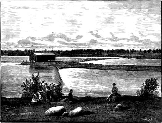
THE GREAT DAM ACROSS THE OTTAWA RIVER, AT CARILLON.
The Grenville Canal (around the Longue Sault) with seven locks, and the Chûte à Blondeau with one lock, are fed directly from Ottawa. But with the Carillon that method was not followed as the nature of the banks there would have in doing so, entailed an immense amount of rock excavation--a serious matter in those days. The difficulty was overcome by locking up at the upper or western end 13 feet and down 23 at lower end, supplying the summit by a 'feeder from a small stream called the North River, which empties into the Ottawa three or four miles below Carillon, but is close to the main river opposite the canal.
In 1870-71 the Government of Canada determined to enlarge these canals to admit of the passage of boats requiring locks 200 feet long, 45 feet wide, and not less than 9 feet of water on the sills at the lowest water. In the case of the Grenville Canal this was and is being done by widening and deepening the old channel and building new locks along side of the old ones. But to do that with the Carillon was found to be inexpedient. The rapidly increasing traffic required more water than the North River could supply in any case, and the clearing up of the country to the north had materially reduced its waters in summer and fall, when most needed. To deepen the old canal so as to enable it to take its supply from the Ottawa would have caused the excavation of at least 1,250,000 cubic yards of rock, besides necessitating the enlargement of the Chûte à Blondeau also.
It was therefore decided to adopt a modification of the plan proposed by Mr. T.C. Clarke, of the present firm of Clarke Reeves & Co, several years before when he made the preliminary surveys for the then proposed "Ottawa Ship Canal," namely to build a dam across the river in the Carillon Rapid but of a sufficient height to drown out the Chûte à Blondeau, and also to give the required depth of water there.
During the summer and fall of 1872 the writer made the necessary surveys of the river with that end in view. By gauging the river carefully in high and low water, and making use of the records which had been kept by the lock masters for twenty years back, it was found that the flow of the river was in extreme low water 26,000 cubic feet per second, and in highest water 190,000 cubic feet per second, in average years about 30,000 and 150,000 cubic feet respectively. The average flow in each year would be nearly a mean between those quantities, namely, about 90,000 cubic feet per second. It was decided to locate the dam where it is now built, namely, about the center of Carillon Rapid, and a mile above the village of that name and to make it of a height sufficient to raise the reach between the head of Carillon and Chûte à Blondeau about six feet, and that above the latter two feet in ordinary water. At the site chosen the river is 1,800 feet wide, the bed is solid limestone, and more level or flat than is generally found in such places--the banks high enough and also composed of limestone. It was also determined to build a slide for the passage of timber near the south shore (see map), and to locate the new canal on the north side.
Contracts for the whole works were given out in the spring of 1873, but as the water remained high all the summer of that year very little could be done in it at the dam. In 1874 a large portion of the foundation, especially in the shallow water, was put in. 1875 and 1876 proved unfavorable and not much could be done, when the works were stopped. They were resumed in 1879, and the dam as also the slide successfully completed, with the exception of graveling of the dam in the fall of 1881. The water was lower that summer than it had been for thirty five years before. The canal was completed and opened for navigation the following spring.
THE DAM
In building such a dam as this the difficulties to be contended against were unusually great. It was required to make it as near perfectly tight as possible and be, of course, always submerged. Allowing for water used by canal and slide and the leakage there should be a depth on the crest of the dam in low water of 2.50 feet and in high of about 10 feet. These depths turned out ultimately to be correct. The river reaches its highest about the middle of May, and its lowest in September. It generally begins to rise again in November. Nothing could be done except during the short low water season, and some years nothing at all. Even at the most favorable time the amount of water to be controlled was large. Then the depth at the site varied in depth from 2 to 14 feet, and at one place was as much as 23 feet. The current was at the rate of from 10 to 12 miles an hour. Therefore, failures, losses, etc., could not be avoided, and a great deal had to be learned as the work progressed. I am not aware that a dam of the kind was ever built, or attempted to be built across a river having such a large flow as the Ottawa.
The method of construction was as follows. Temporary structures of various kinds suited to position, time, etc., were first placed immediately above the site of the dam to break the current. This was done in sections and the permanent dam proceeded with under that protection.
In shallow water timber sills 36 feet long and 12 inches by 12 inches were bolted to the lock up and down stream, having their tops a uniform height, namely, 9.30 feet below the top of dam when finished. These sills were, where the rock was high enough, scribed immediately to it, but if not, they were 'made up' by other timbers scribed to the rock, as shown by Figs 4 and 5. They were generally placed in pairs about 6 feet apart, and each alternate space left open for the passage of water, to be closed by gates as hereafter described. Each sill was fastened by five 1½ in. bolts driven into pine plugs forced into holes drilled from 18 inches to 24 inches into the rock. The temporary rock was then removed as far as possible, to allow a free flow of the water.
In the channels of which there are three, having an aggregate width of about 650 feet, cribs 46 feet wide up and down stream were sunk. In the deepest water, where the rock was uneven, they covered the whole bottom up to about five feet of the level of the silts, and on top of that isolated cribs, 46 in. X 6 in. and of the necessary height were placed seven feet apart, as shown at C Figs 2 and 3. At other places similar narrow cribs were placed on the rock, as shown at D, Figs 2 and 3. The tops of all were brought to about the same level as the before mentioned sills. The rock bottom was cleaned by divers of all bowlders, gravel, etc. The cribs were built in the usual manner, of 12 in. X 12 in. timber generally hemlock, and carefully fitted to the rock on which they stand. They were fastened to the rock by 1½ in. bolts, five on each side of a crib, driven into pine plugs as mentioned for the sills. The drilling was done by long runners from their tops. The upstream side of the cribs were sheeted with 4 in. tamarack plank.
On top of these sills and cribs there was then placed all across river a platform from 36 to 46 feet wide made up of sawed pine timber 12 in. X 12 in., each piece being securely bolted to its neighbor and to the sills and cribs below. It was also at intervals bolted through to the rock.
On top of the "platform" there was next built a flat dam of the sectional form shown by Fig 1. It was built of 12 in. X 12 in. sawed pine timbers securely bolted at the crossings and to the platform, and sheeted all over with tamarack 10 in. thick and the crest covered with ½ in. boiler plate 3 ft. wide. The whole structure was carefully filled with stone--field stone, or "hard head" generally being used for the purpose.
At this stage of the works, namely, in the fall of 1881 the structure presented somewhat the appearance of a bridge with short spans. The whole river--fortunately low--flowed through the sluices of which there were 113 and also through a bulkhead which had been left alongside of the slide with a water width of 60 ft. These openings had a total sectional area of 4,400 sq. ft., and barely allowed the river to pass, although, of course, somewhat assisted by leakage.
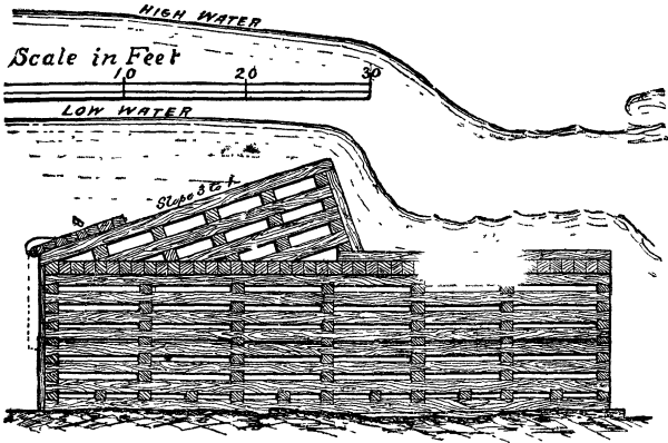
Fig. 1. CROSS SECTION IN DEEP WATER.
It now only remained, to complete the dam, to close the openings. This was done in a manner that can be readily understood by reference to the cuts. Gates had been constructed with timber 10 in. thick, bolted together. They were hung on strong wooden hinges and, before being closed, laid back on the face of dam as shown at B, Figs. 1, 2, and 3. They were all closed in a short time on the afternoon of 9th November, 1881. To do this it was simply necessary to turn them over, when the strong current through the sluices carried them into their places, as shown at A, Figs. 2 and 3 and by the dotted lines on Fig. 1. The closing was a delicate as well as dangerous operation, but was as successfully done as could be expected. No accident happened further than the displacement of two or three of the gates. The openings thus left were afterward filled up with timber and brushwood. The large opening alongside of the slide was filled up by a crib built above and floated into place.
The design contemplates the filling up with stone and gravel on up-stream side of dam about the triangular space that would be formed by the production of the line of face of flat dam till it struck the rock. Part of that was done from the ice last winter; the balance is being put in this winter.
Observations last summer showed that the calculations as to the raising of the surface of the river were correct. When the depth on the crest was 2.50 feet, the water at the foot of the Longue Sault was found to be 25 in. higher than if no dam existed. The intention was to raise it 24 in.
The timber slide was formed by binding parallel piers about 600 feet long up and down stream, as shown on the map, and 28 ft. apart, with a timber bottom, the top of which at upper end is 3 ft. below the crest of dam. It has the necessary stop logs, with machinery to move them, to control the water. The approach is formed by detached piers, connected by guide booms, extending about half a mile up stream. See map.
Alongside of the south side of the slide a large bulkhead was built, 69 ft. wide, with a clear waterway of 60 ft. It was furnished with stop logs and machinery to handle them. When not further required, it was filled up by a crib as before mentioned.
The following table shows the materials used in the dam and slide, and the cost:
______________________________________________________________________ | | | Stone | Exca- | | | Timber, | Iron, | filling, | vation, | Cost. | | cu. ft. | lb. | cu. yds. | cu. yds.| | +---------+---------+----------+---------+----------+ Temporary works | 134,500 | 92,000 | 11,400 | | $79,000 | | | | | | | Permanent dam | 265,000 | 439,600 | 24,000 | 6,500 | 151,000 | | | | | | | Slide, including | 296,500 | 156,400 | 32,800 | | 102,000 | apparatus | | | | | | +---------+---------+----------+---------+----------+ | | | | | | Total | 696,000 | 687,000 | 68,200 | 6,500 | $332,000 | -----------------+---------+---------+----------+---------+----------+
The above does not include cost of surveys, engineering, or superintendence, which amounted to about ten per cent, of the above sum.
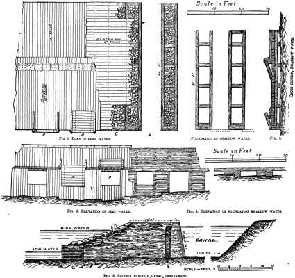
DETAILS OF THE OTTAWA RIVER DAM, AT CARILLON.
The construction of the dam and slide was ably superintended by Horace Merrill, Esq., late superintendent of the "Ottawa River Improvements," who has built nearly all the slides and other works on the Ottawa to facilitate the passage of its immense timber productions.
The contractors were the well known firm of F.B. McNamee & Co., of Montreal, and the successful completion of the work was in a large degree due to the energy displayed by the working member of that firm--Mr. A.G. Nish, formerly engineer of the Montreal harbor.
THE CANAL
The canal was formed by "fencing in" a portion of the river-bed by an embankment built about a hundred feet out from the north shore and deepening the intervening space where necessary. There are two locks--one placed a little above the foot of the rapid (see map), and the other at the end of the dam. Wooden piers are built at the upper and lower ends--the former being 800 ft. long, and the latter 300 ft; both are about 29 ft. high and 35 ft. wide.
The embankment is built, as shown by the cross section, Fig. 6. On the canal side of it there is a wall of rubble masonry F, laid in hydraulic cement, connecting the two locks, and backed by a puddle wall, E, three feet thick; next the river there is crib work, G, from ten to twenty feet wide and the space between brick-work and puddle filled with earth. The outer slope is protected with riprap, composed of large bowlders. This had to be made very strong to prevent the destruction of the bank by the immense masses of moving ice in spring.
The distance between the locks is 3,300 feet.
In building the embankment the crib-work was first put in and followed by a part (in width) of the earth-bank. From that to the shore temporary cross-dams were built at convenient distances apart and the space pumped out by sections, when the necessary excavation was done, and the walls and embankments completed. The earth was put down in layers of not more than a foot deep at a time, so that the bank, when completed, was solid. The water at site of it varied in depth from 15 feet at lower end to 2 feet at upper.
The locks are 200 ft. long in the clear between the gates, and 45 ft wide in the chamber at the bottom. The walls of the lower one are 29 ft. high, and of the upper one 31 ft They are from 10 to 12 ft thick at the bottom,
The locks are built similar to those on the new Lachine and Welland canals, of the very best cut stone masonry, laid in hydraulic cement. The gates are 24 in. thick, made of solid timber, somewhat similar to those in use on the St. Lawrence canals. They are suspended from anchors at the hollow quoins, and work very easily. The miter sills are made of 26 in. square oak. The bottom of the lower lock iis timbered throughout, but the upper one only at the recesses, the rock there being good.
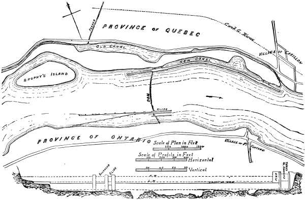
MAP OF THE OTTAWA RIVER AT CARILLON RAPIDS. SECTION OF RIVER AT DAM. NOTE.--THE LOWEST DOTTED LINE IS LOW WATER BEFORETHE DAM WAS BUILT. THEN THE LINE OF HIGH WATER WAS ABOUT A FOOT ABOVE WHAT IS CREST OF DAM NOW.
The rise to be overcome by the two locks is 16 ft., but except in medium water, is not equally distributed. In high water nearly the whole lift is on the upper lock, and in low water the lower one. In the very lowest known stage of the river there will never be less than 9 ft. on the miter sills.
As mentioned at the beginning of this article, four locks were required on the old military canal to accomplish what is now done by two.
The canal was opened in May, 1882, and has been a great success, the only drawback--although slight--being that in high water the current for about three-quarters of a mile above the upper pier, and at what was formerly the Chute a Biondeau, is rather strong. These difficulties can be easily overcome--the former by building an embankment from the pier to Brophy's Island, the latter by removing some of the natural dam of rock which once formed the "Chute."
The following are, in round numbers, the quantities of the principal materials used:
Earth and puddle in embankment ...cub. yds. 148,500 Rock excavation, " 38,000 Riprap, " 6,600 Lock masonry " 14,200 Rubble masonry, " 16,600 Timber in cribs, lock bottoms and gates " 368,000 Wrought and cast iron, lb ................. 173,000 Stone filling cu yds ...................... 45,300 Concrete " 830
The total cost to date has been about $570,000, not including surveys, engineering, etc.
The contractors for the canal, locks, etc., were Messrs. R. P. Cooke & Co., of Brockville, Ont., who have built some large works in the States, and who are now engaged building other extensive works for the Canadian Government. The work here reflects great credit on their skill.
On the enlarged Grenville Canal, now approaching completion, there are five locks, taking the place of the seven small ones built by the Imperial Government. It will be open for navigation all through in the spring of 1884, when steamers somewhat larger than the largest now navigating the St. Lawrence between Montreal and Hamilton can pass up to Ottawa City.--Engineering News.