4. Methods of Investigation.—The quantity of silt in water is found by taking specimens of the water and evaporating it or, if the silt is present in great quantity, leaving it to settle for twelve hours—an ounce of alum can be added for every 10 cubic feet of water to accelerate settlement—drawing off the water by a syphon, and heating the deposit to dry it. The deposit is then measured or weighed. It is best to weigh it. If clay is filled into a measure, the volume depends greatly on the manner in which it is filled in. When silt deposits in large quantities in a channel, or when heavy scour occurs, the volume deposited or scoured is ascertained by taking careful sections of the channel.
Reading edition
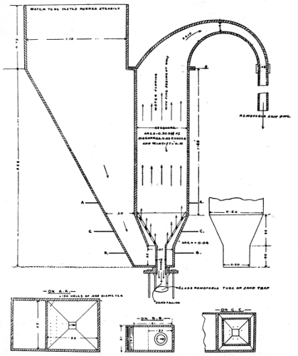
Fig. 1.
Silt is best classified by observing its rate of fall through still water. A sand which falls at ·10 feet per second is, in India, called class (·1), and mixed sand which falls at rates varying from ·1 to ·2 feet per second is called class ·1/·2. Fig. 1 shows a sand separator designed by Kennedy. The scale is ⅛. It has a syphon action, and the rate of flow can be altered by altering the length of the exit pipe. Suppose it is desired to measure the sand of class (·10) and all heavier kinds. The pipe is adjusted so as to give a velocity of ·1 foot per second to the upward flowing water, which then carries off all silt of class (·10) or finer. All heavier silt falls into the glass tube. It can be separated again by being mixed with water and passed through the instrument again, the velocity of flow through the instrument being increased.
The quantity of silt present at various depths can be found by pumping specimens of water through pipes. At each change of depth the pipe, delivery hose, etc., should be cleaned. Allowance must be made for the velocity of ascent of the water up the pipe. Suppose this to be 1·4 feet per second. Then the velocity of sand of class (·2) would be 1·2 feet per second, and the quantity of sand actually found in the water would have to be increased by one-sixth.
5. Quantity and Distribution of Silt.—The quantity of silt present in water varies enormously. Fine mud, even though sufficient to discolour the water, may be so small in volume that it only deposits when the water is still, and even then deposits slowly. In the river Tay, near Perth, the silt was found to be ordinarily 1/10,000 of the volume of water, and at low water only 1/28,000. In the river Sutlej at Rupar, near where it issues from the Himalayas, the silt in the flood season is extremely heavy. Out of 360 observations, made at various depths, during the flood seasons of four successive years, in water whose depth ranged up to 12 feet, the silt was once found to be 2·1 per cent. by weight of that of the water. It was more than 1·2 per cent. on four occasions, and more than 0·3 per cent. (or 3 in 1000) on sixty-four occasions. Generally about one-half of the silt was clay and sand of classes finer than (·10), about one-third was sand of class ·1/·2, and the residue was sand of class ·2/·3. The sand of the river Chenab is generally coarser than that of the Sutlej. There are very great differences in the degree of coarseness of river sand. The sand in any river becomes finer and finer as the gradient flattens in approaching the sea. Sea sand has been found to be of class (·20). In the Sirhind Canal, which takes out from the Sutlej at Rupar, the maximum quantity of suspended silt observed in the four flood seasons was 0·7 per cent., on one occasion out of 270, and it exceeded 0·3 per cent. on twenty-five occasions. About 80 per cent. of the silt was clay.
In another part of the paper quoted, it is stated that the silt suspended in the canal water averaged, during the whole of one flood season, about 1/1700 of the volume of the water. This would be about 1/1200 by weight. The silt deposited in the bed of the canal, in a period of a few days, was sometimes as much as 1/1000 of the water which had passed along, and occasionally as much as 1/500. It was nearly all sand, only about 3 per cent. being clay. Silt of classes finer than (·1) gave no trouble, and were to be eliminated in future investigations. In a canal, as in a river, the sand on the bed becomes finer the further from the head.
Regarding the distribution of the silt at various depths, in water 5 to 17 feet deep, the quantity of silt near the bed may, when the charge is heavy and consists of mixed silt, be 1¼ to 3 times that at the surface. If the charge is fine mud, there is likely to be as much silt at the surface as near the bed, if sand, there may be none at the surface and little in the upper part of the stream.
In all cases single observations are likely to show extraordinarily discordant results; a number of observations must be made at each point and averaged.
6. Practical Formulæ and Figures.—A stream which carries silt generally rolls materials along its bed. The proportion between the quantities of material rolled and carried is never known, and this makes it impossible to frame an exact formula applicable to such cases, but Kennedy, from his observations on canals fully charged with the heavy silt and fine sand usually found in Indian rivers near the hills, arrived at the empirical formula for critical velocities V = ·84 D·64 The observations were made on the Bari Doab Canal and its branches, the widths of the channels varying from 8 feet to 91 feet, and the depths of water from 2·3 feet to 7·3 feet. The beds of these channels have, in the course of years, adjusted themselves by silting or scouring, so that there is a state of permanent régime, each stream carrying its full charge of silt, and the charges in all being about equal. From further observations referred to above (Art. 3, par. 2) it appears that this kind of silt forms about 1/3300 of the volume of the water, and that on the Sirhind Canal, sand coarser than the (·10) class, formed 1/35,000 of the volume of water.
The formula gives the following critical velocities for various depths:—
D = 1 2 3 4 5 6 7 8 9 10
V0 = ·84 1·30 1·70 2·04 2·35 2·64 2·92 3·18 3·43 3·67.
In Indian rivers not near the hills the silt carried is not so heavy, and the critical velocities are supposed to be about three-fourths of the above. Thrupp (Min. Proc. Inst. C.E., vol. clxxi.) gives the following ranges of velocities as those which will enable streams to carry different kinds of silt. It does not appear that the streams would be fully charged except at the higher figure given for each case.
D = 1·0 10·0
V = 1·5 to 2·3 3·5 to 4·5 (Coarse sand).
V = ·95 to 1·5 2·3 to 3·5 (Heavy silt and fine sand).
V = ·45 to ·95 1·2 to 2·3 (Fine silt).
It cannot be said that the exact relations between D and V are yet known, but it is of great practical importance to know that V must vary with D. The precise manner in which it must vary does not, for moderate changes, make very much difference. In designing a channel a suitable relation of depth to velocity can be arranged for, and one quantity or the other kept in the ascendant, according as scouring or silting is the evil to be guarded against.
The old idea was that an increase in V, even if accompanied by an increase in D, e.g. simply running a higher supply in a given channel, gave increased silt-transporting power. In a stream of very shallow section this is probably correct, for V increases faster than D·64 (Hydraulics, Chap. VI., Art. 2). In a stream of deep section a decrease in D gives increased silt-transporting power. If the discharge is fixed, a change in the depth or width must be met by a change of the opposite kind in the other quantity. In this case widening or narrowing the channel may be proper according to circumstances. In a deep section widening will decrease the depth of water, and may also increase the velocity, and it will thus give increased scouring power. In a shallow section, narrowing will increase the velocity more than it increases D·64. In a medium section it is a matter of exact calculation to find out whether widening or narrowing will improve matters.
If the water entering a channel has a higher silt-charge than can be carried in the channel, some of it must deposit. Suppose an increased discharge to be run, and that this gives a higher silt-carrying power and a smaller rate of deposit per cubic foot of discharge, it does not follow that the deposit will be less. The quantity of silt entering the channel is now greater than before. Owing to want of knowledge regarding the proportions of silt and rolled material, and to want of exactness in the formulæ, reliable calculations regarding proportions deposited cannot be made.
The channels in which the observations above referred to were made have all assumed nearly rectangular cross-sections, the sides having become vertical by the deposit on them of finer silt; but the formula probably applies approximately to any channel if D is the mean depth from side to side, and V the mean velocity in the whole section.
If the ratio of V to D differs in different parts of a cross-section, there is a tendency towards deposit in the parts where the ratio is least, or to scour where it is greatest. There is a tendency for the silt-charge to adjust itself, that is, to become less where the above ratio is less, but the irregular movements of the stream cause a transference of water among all parts, and this tends to equalise the silt-charge.
Dubuat gives the following as the velocities close to the bed which will enable a stream to scour or roll various materials. The bed velocity is probably less than the mean velocity in the ratio of about ·6 to 1 in rough channels, and about ·7 to 1 in smooth channels:—
Gravel as large as peas ·70 feet per second
Gravel as large as French beans 1·0 feet per second
Gravel 1 inch in diameter 2·25 feet per second
Pebbles 1½ inch in diameter 3·33 feet per second
Heavy shingle 4·0 feet per second
Soft rock, brick, earthenware 4·5 feet per second
Rock of various kinds 6·0 feet per second
and upward.
The figures for brick, earthenware, and rock can apply only to materials of exceedingly poor quality. Masonry of good hard stone will stand 20 feet per second, and instances have occurred in which brickwork has withstood a velocity of 90 feet per second without injury so long as the water did not carry sand and merely flowed along the brickwork. If there are abrupt changes in the stream, causing eddies, or if there is impact and shock, or if sand, gravel, shingle, or boulders are liable to be carried along, velocities must be limited.
7. Action on the Sides of a Channel.—It has been seen that the laws of silting and scour on the bed of a channel depend on the ratio of the depth to the velocity. The same laws probably hold good in the case of a gently shelving bank, so that here again V ought to vary as D·64. The velocity near the angle where the slope meets the water surface seems to decrease faster than D·64. At all events, silt tends to deposit in the angle and the slope to become steep.
When the slope is steep the law seems to be different, the tendency for deposit or scour to occur on the bank depending on the actual velocity without much relation to the depth. The velocity very near to a steep bank is always low relatively to that in the rest of the stream. Thus there is often a tendency for silt to deposit on the bank, especially in the upper part, and for the side to become vertical except for a slight rounding at the lower corner. A bank may receive deposits when the bed may be receiving none, and it may have a persistent tendency to grow out towards the stream. The growth of the bank is generally regular, the line of the bank being preserved, but it may be irregular, especially if vegetation, other than small grass, becomes established on the new deposits.
When scour of the sides of a channel occurs it may occur by direct action of the stream on the sides near the water-level, or by action at or near the toe of the slope, which causes the upper part of the bank to fall in. Such falling in is generally more or less irregular, and the bank presents an uneven appearance. The fallen pieces of bank may remain, more or less intact, especially if they are held together by the roots of grasses, etc., where they fell, and prevent further scour occurring along the toe of the slope. Falling in of banks is most liable to occur in large streams and with light soils. It may be caused by the waves which are produced by steamers and boats or, especially in broad streams, by wind. The action on the banks at bends is discussed in Art. 8.
Thus in designing a channel according to the principles laid down in Art. 6, the question of action on the sides of the channel has to be dealt with as follows. Whether or not the velocity is to be low, relatively to the depth, i.e. whether or not deposit on the bed is more likely to occur than scour, care can be taken not to make it actually too low, and not to make it actually too high, particularly if the soil is light and friable. With ordinary soils a mean velocity of 3·3 feet per second in the channel is generally safe as regards scour of the sides. Any velocity of more than 3·5 feet per second may give trouble. A velocity of less than 1 foot per second is likely to give rise to deposit on the sides.
In channels in alluvial soils the falling in of banks is sometimes said to occur more when the stream is falling than at other times. This has been noticed on both the Mississippi and the Indus. The cause has been said to be the draining out of water which had percolated into the bank, the water in flowing out carrying some sand with it. The effect of this cannot however be great.
8. Action at Bends.—At a bend, owing to the action of centrifugal force and to cross-currents caused thereby, there is a deposit near the convex bank and a corresponding deepening—unless the bed is too hard to be scoured—near the concave bank. The water-level at the concave bank is slightly higher than at the convex bank. The greatest velocity instead of being in mid-stream is nearer the concave bank.
As the transverse current and transverse surface slope cannot commence or end abruptly, there is a certain length in which they vary. In this length the radius of curvature of the bend and the form of the cross-section also tend to vary. This can often be seen in plans of river bends, the curvature being less sharp towards the ends.
When once a stream has assumed a curved form, be it ever so slight, the tendency is for the bend to increase. The greater velocity and greater depth near the concave bank react on each other, each inducing the other. The concave bank is worn away, or becoming vertical by erosion near the bed, cracks, falls in, and is washed away, a deposit of silt occurring at the convex bank, so that the width of the stream remains tolerably constant. The bend may go on increasing, and it often tends to move downstream.
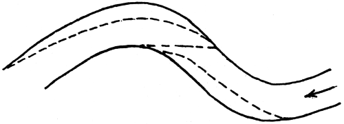
Fig. 2.
In fig. 2 the deep places are shown by dotted lines. Along the straight dotted line there is no deep place. Such a line would be used for a ford. At low water it becomes a shoal. This is the chief reason why a tortuous stream at low water consists of alternate pools and rapids. It is sometimes said that deep water occurs near to a steep hard bank. Such deepening is due to bends or obstructions which give the current a set towards the bank, or it is due to irregularities in the bank which cause eddies. In a straight channel with even and regular banks there is no such deepening.
When a bend has formed in a channel previously straight, the stream at the lower end of the bend, by setting against the opposite bank, tends to cause another bend of the opposite kind to the first. Thus the tendency is for the stream to become tortuous and, while the tortuosity is slight, the length, and therefore the slope and velocity, are little affected; but the action may continue until the increase in the length of the stream materially flattens the slope, and the consequent reduction in velocity causes erosion to cease. Or the stream during a flood may find, along the chord of a bend, a direct route with, of course, a steeper slope. Scouring a channel along this route it straightens itself, and its action then commences afresh. Short cuts of this kind do not, however, occur so frequently as is sometimes believed. In some streams the bends acquire a horse-shoe shape and the neck becomes very narrow and short cuts may then occur. Otherwise they are not common. V increases only as √(S), and if the country is covered with vegetation it is not easy for a stream to scour out a new channel.
The effect of bends on the velocity of a stream is not well understood. In case of a bend of 90° the increased resistance to flow when the bend is absolutely sudden (a sudden bend is known as an “elbow”) amounts perhaps to V2/(2g). Whether it is greater or less in the case of a gentle bend of 90° is not known. In the case of a pipe there is a certain radius which gives a minimum resistance (Hydraulics, Chap. V.). The increased resistance at a bend is due partly to the fact that the maximum velocity is no longer in the centre of the stream, and partly to the fact that the velocities at the different parts of the cross-section have to be rearranged at the commencement of the bend and again at its termination. Thus the effect of a bend of 45° is a good deal more than half of that of a bend of 90°. Two bends of 45°, both in the same direction, with a straight reach between them, will cause more resistance than a single bend of 90° with the straight reach above or below the bend. If the two bends of 45° are in different directions the resistance will be still greater. A succession of sharp bends may produce a serious effect, amounting to an increase in roughness of the channel. A succession of gentle bends, of any considerable angle, cannot of course occur within a moderate length of channel.
When there is head to spare there is clearly no objection to bends, except that the bank may need protection. At a place where the bank has in any case to be protected, e.g. at a weir, there is no objection to an elbow.
9. General Tendencies of Streams.—Since the velocity is greater as the area of the cross-section is less, a stream always tends to scour where narrow or shallow, and to silt where wide or deep. The cross-section thus tends to become uniform in size. Suppose two cross-sections to be equal in size but different in shape. The velocities of the two sections will be equal. The tendency of the bed to silt will (Art. 6) be greater at the deeper section and, when silting has occurred on the bed, the section will be reduced and there will be a tendency to scour at the sides. Thus the cross-sections tend to become also uniform in shape. If a bank of silt has formed in a stream, the tendency is for scour to occur. There is also a tendency for silt to deposit just below the point where the bank ends. Hence a silt bank often moves downstream.
Owing to the tendency to scour alongside of, or downstream of, obstructions (Art. 1), it is clear that a stream constantly tends to destroy obstructions.
There is an obvious tendency for silt to deposit where the bed slope of a stream flattens, and for scour to take place where it steepens (Hydraulics, figs. 16 and 17, pp. 24 and 25), and thus the tendency is for the slope to become uniform.
In a natural stream flowing from hilly country to a lake or sea, the slope is steepest at the commencement and gradually flattens. There is thus a tendency for the bed to rise except at the mouth of the stream. This rising tends to increase the slope and velocity in the lower reaches, and this again enhances the tendency, described in the preceding article, of the stream to increase in tortuosity.
When a silt-bearing stream overflows its banks the depth of water on the flooded bank is probably small and its velocity very low, and a deposit of silt takes place on the bank. When the deposit has reached a certain height it acts like a weir on the water of the next flood, which flows quickly over it and, instead of raising it higher, deposits its silt further away from the stream. In this way a strip of country along the stream gradually becomes raised, the raising being greatest close to the stream. The country slopes downwards in going away from the stream. In other words, the stream runs on a ridge. If the bank becomes raised so high that flooding no longer occurs, the raising action ceases, but if, as is likely in alluvial country, the bed of the stream also rises, the action may continue and the ridge become very pronounced.
Some rivers have very wide and soft channels which are only filled from bank to bank in floods, if then. The deep stream winds about in the channel, and the rest of it is occupied by sandbanks and minor arms. The winding is the result of the velocity being too great for the channel. The streams, especially the main stream, constantly shift their courses by scouring one bank or the other. Now and then the main stream takes a short cut, either down a minor arm or across an easily eroded sandbank. This is a very different matter from a short cut across high ground. The sandbanks receive deposits of silt in floods, but are constantly being cut away at the sides. Such rivers frequently erode their banks to an extraordinary extent. The Indus sometimes cuts into its bank 100 feet or more in a day, and it may cut for half a mile or more without cessation. The tortuosity of such a stream increases as it gets nearer the sea. The actual length of the Indus in the 400 miles nearest the sea is 39 per cent. greater than its course measured along the bank. In the reach from the 600th to the 700th mile from the sea, the difference is only 3 per cent. For a detailed description of some such rivers, see Punjab Rivers and Works.
Sometimes general statements are made regarding silting or scour in connection, for instance, with a stream which is confined between embankments or training walls, or has overflowed its banks or is held up by a weir. It is impossible to say that any such condition, or any condition, will cause silting or scour, unless the velocity depth and silt charge are known.