INDEX.
Reading edition
Abajo Mountains, 67, 69, 152
Agricultural lands, 152
Alluvial cones and alluviation, 133, 139
Alpine sculpture, 36, 38
Altitudes of peaks and passes, 3, 117
Analogues of the laccolite, 98
Ancient rivers no larger than modern, 133
Antecedent drainage, 143
Arch, Bowl Creek, 45 , Crescent, 44 , Dana, 43 , G, 43 , Maze, 44 , Pulpit, 33, 147
Arches, Forces which produced laccolitic, 87
Aridity favorable to geological examination, 2, 98 of the Colorado Basin in former times, 120
Aubrey Sandstone, 8
Bad-lands, Sculpture of, 120, 140
Bischof, on contraction of igneous rocks in cooling, 76
Blue Gate flexure, 13 Sandstone, 4 Shale, 4
Bonneville, Outlet of Lake, 134
Bowl Creek arch, 45
Cañons of the Colorado as obstructions to travel, 1, 151 as evidence of arid climate, 120
Carboniferous strata, 8
Carriso Mountains, 69, 152
Circle Cliffs, 14
Cleavage, Slaty, not found, 66 , Vertical, produced by sapping, 55
Cliffs, Circle, 14
Climate, Arid, favorable to geological examination, 2, 98 , General influence of, on erosion, 103 , Influence of, on sculpture, 117
Coal, 5, 151
Colorado Basin, History of the, 84 Desert, 134 River, Origin of the, 85
Colors of sandstones, Local variation of, 7
Comminution of detritus aids transportation, 106
Competence, 110
Conditions of rock flexure, 83
Cones, Alluvial, 133
Consequent drainage, 143
Contact phenomena, 65
Contraction of igneous rocks by cooling, 75, 80
154Corrasion, 100, 101 , Relation of, to declivity, 112 , to friction of flow, 109 , to transportation, 111
Cover of the laccolites, Depth of the, 86, 94
Crescent arch, 44
Cotta, Prof. Bernhard von, cited, 75
Cretaceous period, Disturbance at the close of the, 10, 85 rock series, 4
Cross-lamination, Inclination of, 7
Dana arch, 43
Declivity, General influence of, upon erosion, 102 of stream beds, relation to corrasion, 112 , relation to transportation, 108 , Relation of, to quantity of water, 113
Declivities, Influence of unequal, on divides, 140
Degradation (see Erosion), 99, 115
Delesse on contraction of igneous rocks in cooling, 76
Densities of igneous rocks, 75 of sedimentary rocks, 77
Density a condition of laccolitic intrusion, 73, 74 of porphyritic trachyte, 77
Denudation (see Erosion), 99, 115 of laccolites, 21
Deposition by running water, 111
Diameters of laccolites, 92
Dike near Mount Ellsworth, 59
Dikes and sheets defined, 20 , Flat-topped, 28 of Mount Ellsworth, 23 of Mount Holmes, 28 , Relation of, to strains, 96
Dinah Creek Pass, 3
Dirty Devil River, Flood-plains of, 131
Distances, Table of, 17
Distribution of laccolites, Horizontal, 20, 30 , Vertical, 21, 56
Divides in bad-lands, Rounding of, 122 , Instability of, 139 , Law of, 116 , Stability of, 138
Drainage lines, Instability of, 125 , Stability of, 124 , Systems of, 124, 143
Dutton, Capt. C. E., on the intrusive rocks, 61
Economic geology, 151
Elk Mountains, 69
Ellen Mount (see Mount Ellen).
Ellsworth Mount (see Mount Ellsworth).
Energy of muddy streams, 108 streams, how measured, 106
Equal action, Principle of, 123
Erosion, Conditions which control, 102 , Influence of climate upon, 103 , Influence of declivity upon, 102
155Erosion, Influence of rock texture upon, 103 , Influence of vegetation upon, 104 of Mount Ellsworth, 25 , Principles of, 99 , Processes of, 99
Farming lands, 152
Faults on Mount Ellsworth, 23 Mount Holmes, 28 , Region of, 12, 15
Fish Lake Valley, Structure of, 14
Fissure veins limited in depth, 82 not found in the Henry Mountains, 83, 151
Flaming Gorge Group, 6
Flat-topped dikes, 28
Flexure of rocks, Conditions of, 83
Flood-plain defined, 127
Flow of streams, Friction of, 107, 109
Folds, The Great, 10, 11, 85
Forces which produce laccolitic arches, 87
Form of laccolites, 55
Frost, 104
Friction of flow of streams, 107, 109
Geikie laccolite, 41
Gold and silver, 151
Granite, Eruptive, 70
Graves, Mr. Walter H., 1
Gray Cliff Group, 6
Grazing lands, 152
Heights, 3, 117
Henry, Prof. Joseph, 1
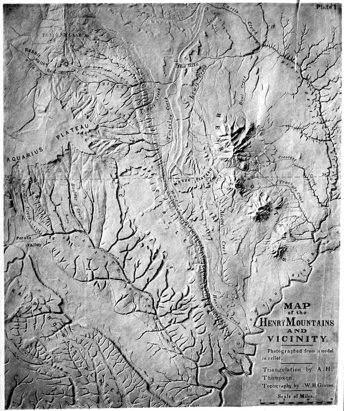
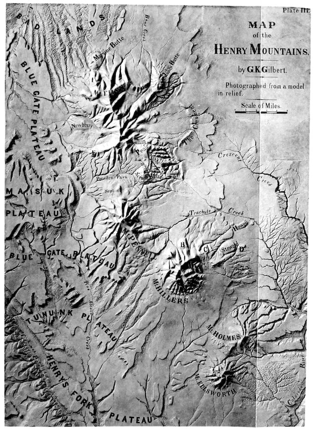
Henry Mountains, Altitudes of the, 2, 117 caused by resistance of trachyte to erosion, 25, 35 , Contributions of the, to the principles of erosion, 99 , Detailed description of the, 22 , Drainage of the, 144 , Economic value of the, 152 , Planation in the, 127, 149 , Relation of vegetation to type of sculpture in the, 118 , Route of travel to the, 14; their structure laccolitic, 19, 53
Henry’s Fork Group, 4
Hillers, Mount (see Mount Hillers).
Hills of planation, 130
Historical note, 66
History of the Colorado Basin, 84
Holmes, Mount (see Mount Holmes).
Holmes, Mr. W. H., on the Elk Mountains, 70 La Lata and Carriso Mountains, 69
Hopkins on the power of currents, 106
Howell laccolite, 34 , Mr. Edwin E., Fossils discovered by, 5; observation of the Henry Mountains, 66; observation of the Navajo Mountain, 69
Hydrostatic equilibrium, Law of, 72
Igneous mountains of the Plateau Province, 67
156Igneous rocks, Contraction of, by cooling, 75, 80
Inconsequent drainage, 143
Instability of divides, 139 drainage lines, 125
Interdependence of drainage slopes, 123, 141
Internal structure of laccolites, 55
Intrusive rocks of the Henry Mountains, 59, 61
Isolation of the Henry Mountains, 2, 18
Jerry Butte, 34
Jukes Butte, 46
Jukes, Prof. J. Beete, on prismatic structure, 76
Jura-Trias rock series, 5
Kaibab structure, 11
Laccolite A, 32 B, 32 C, 32 D, 35 E, 41 F, 42 , Geikie, 41 H, 46 , Hillers, 30 , History of the, 95 , Howell, 34 , Jukes, 46 , Marvine, 42 , Newberry, 41 of Mount Ellsworth, 27 of Mount Pennell, 36 of the western base of Mount Ellen, 40 , Peale, 47 , Possible analogues of the, 98 , Scrope, 47 , Sentinel, 38 , Shoulder, 42 , Steward, 32 , The, defined, 19
Laccolites, Age of the, discussed, 84 , Composite, 55 , Denudation of, 21 , Depth of cover of, 86, 94 , Detailed description of, 22 , Diameters of, 92 , Form of, 55, 91 , Holmes, 27 , Horizontal, distribution of, 20 intruded in soft beds, 58 , Limital area of, 90, 97 thickness of, 91 , Material of, 59 not prismatic, 55 of the Elk Mountains, 70 of other regions, 97; size limited, 86 subsequent to the strata which inclose them, 51 157, Vertical distribution of, 21, 56, 65
Laccolitic mountains of the Plateau Province, 67, 69 structure characteristic of the Henry Mountains, 19, 53 Sierra La Sal, etc., 69 conditioned by densities, 74 correlated with acidic lavas, 71 , Discussion of the origin of, 72
Lake Bonneville, Outlet of, 134 , Great Salt, Outlet of, 134 Winipeg, Origin of, 126
Land, Agricultural, 152 , Grazing, 152 sculpture, Principles of, 99, 115 , Timber, 152
La Lata Mountains, 68, 69, 152
La Sal Mountains, 68, 69, 152
Law of divides, 116 , Exception to the, 122
Lewis Creek plain, 128
Limital area of laccolites, 90, 97 thickness of laccolites, 91
Load, Relation of, to comminution, 107
Mallet, Robert, C. E., on contraction of igneous rocks in cooling, 76
Marvine laccolite, 42
Ma-suk’ Plateau, 13 Sandstone, 4 Shale, 4
Maze arch, 44
Metamorphism in the Henry Mountains, 65 on Mount Ellen, 38 Ellsworth, 24 Hillers, 31 Holmes, 28
Minerals of the Henry Mountains, 61, 64
Monoclinal shifting, 135, 140
Mount Ellen, Character of sculpture of, 118 , Drainage of, 148 , Structure of, 38 , Topography of, 3 , Vegetation of, 118 Ellsworth, Character of sculpture of, 25, 118 , Drainage of, 145 , Stereogram of, 23, 95 , Structure of, 22 , Topography of, 3 , Vegetation of, 118 Hillers, Character of sculpture of, 119 , Drainage of, 147 , Structure of, 30 , Topography of, 3 , Vegetation of, 118 Holmes, Character of sculpture of, 118 , Drainage of, 146 , Structure of, 27 , Topography of, 3
158Mount Holmes, Vegetation of, 118 Pennell, Character of sculpture of, 119 , Drainage of, 148 , Structure of, 35 , Topography of, 3 , Vegetation of, 118
Mount Taylor, 71
Mud-cracks, Fossil, 9
Navajo Mountain, 69, 152
Newberry, Dr. J. S., on the Sierra Abajo, 67 La Sal, 68 laccolite, 41
Oblique lamination, Inclination of, 7
Peale, Dr. A. C., on igneous mountains of Colorado, 69 on the Elk Mountains, 70
Peale laccolite, 47
Pennell, Mount (see Mount Pennell).
Pennellen Pass, 3
Pine Alcove Creek, Former course of, 130
Planation, 126, 139 , Hills of, 130
Plasticity of solids, 82, 83, 97
Plateaus enumerated, 13
Precipitation from running water, 111
Pressure a condition for rock flexure, 81, 83, 96
Prismatic structure, Absence of, 55, 76 defined, 55
Ponding, 125, 139
Porphyritic trachyte, 60, 64
Porphyry; use of term discussed, 63
Powell, Prof. J. W., on the climate of the Colorado Basin, 120
Pulpit arch, 33, 147
Rankine on flexure of beams, 90
Red Gate flexure, 13 , Flood-plains of, 131 , The, 16
Revet-crags defined, 25 of Mount Hillers, 31 of Mount Holmes, 29 of Mount Pennell, 37
Ripple-marks, Fossil, 16
River terraces produced by planation, 132
Rivers, Ancient, no greater than modern, 133
Rock texture, Influence of, on sculpture, 115, 135, 140 , General influence of, on erosion, 103
Rocks of the Henry Mountains, Intrusive, 59, 61 , Sedimentary, 3
Rotation of the earth, 142
Route to the Henry Mountains, 14
San Rafael fold, 16, 18
Scrope laccolite, 47
Sculpture, Alpine, 36, 38 influenced by climate, 117 distribution of divides, 116 rock structure, 115, 135, 140
159Sculpture of bad-lands, 120 of Mount Ellsworth, 25 , Principles of, 99, 115
Sentinel Butte, 38
Sheets and dikes defined, 20 of Mount Ellsworth, 24 of Mount Holmes, 28 , Relation of, to strains, 96
Shin-ar’-ump Group, 6
Shoulder laccolite, 42
Sierra Abajo, 67, 69, 152 Carriso, 79, 152 La Lata, 68, 69, 152 La Sal, 68, 69, 152
Solidity of rocks not absolute, 82, 83, 97
Specific gravities (see Densities).
Specimens of Henry Mountain trachyte, 60
Springs; relation to soft strata explained, 82
Stability of divides, 138 of drainage lines, 124
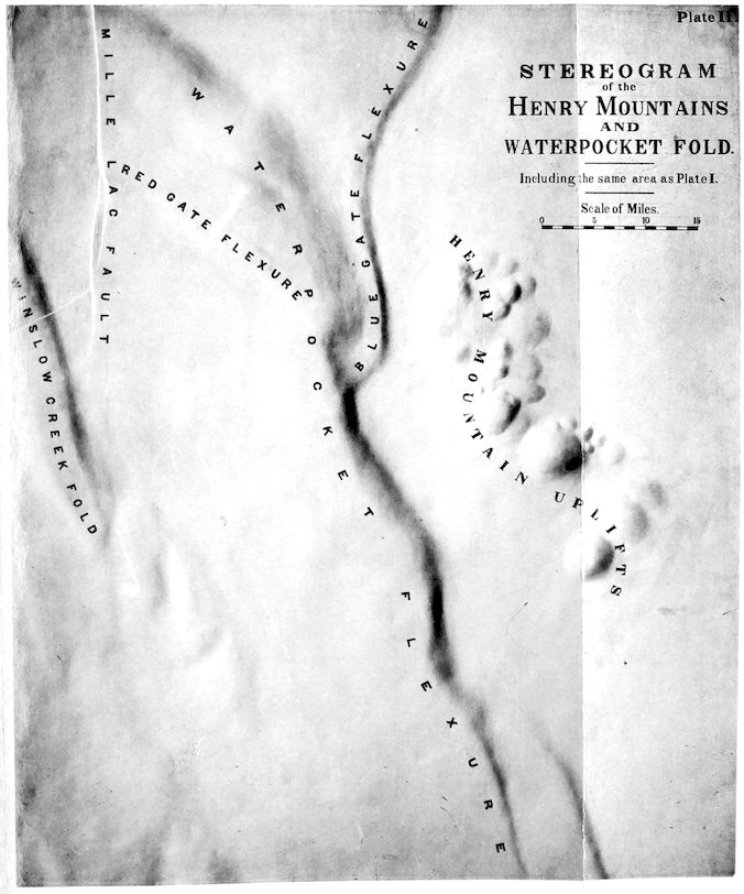
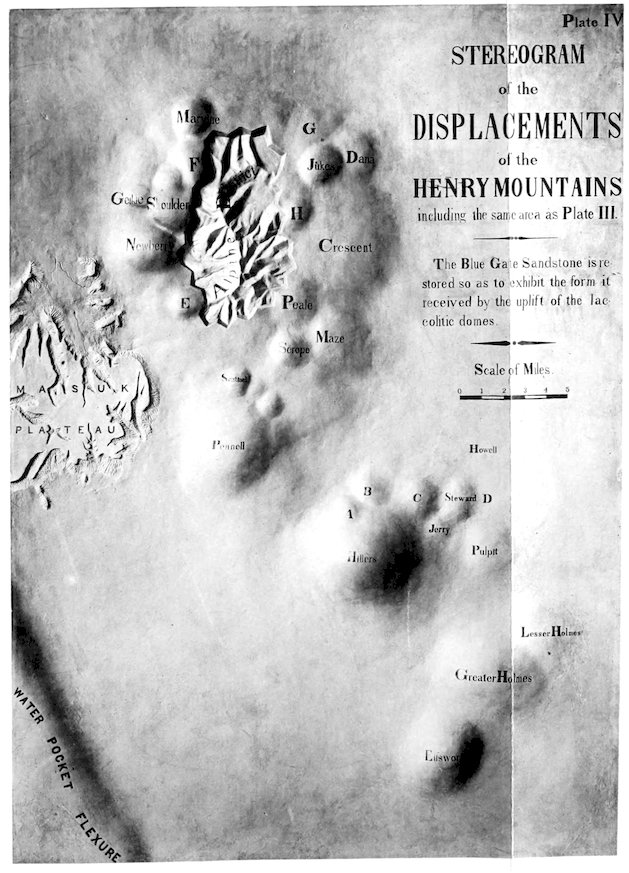
Stereogram, how made, 11, 49 of Mount Ellsworth, 23, 95 of the Henry Mountains, 49 and Waterpocket flexure, 11
Steward laccolite, 32 , Mr. John F., cited, 66
Strains shown by dikes and sheets, 96
Stretching of strata, 80
Structure, Law of, 115
Suncracks, Fossil, 9
Superimposed drainage, 144
Systems of drainage, 124, 143
Table of altitudes, 117 densities of sedimentary rocks, 78 in order of superposition, 79 trachytes, 77 diameters of laccolites, 92 distances, 17 mean densities of certain rock series, 80
Tantalus Creek, 17 , Flood-plains of, 131
Taylor, Mount, 71
Temple Creek, 16 , Flood-plains of, 131
Terraces, River, produced by planation, 132
Tertiary strata protected by lava, 12
Thicknesses of individual strata, 7
Thompson, Prof. A. H., 1, 66
Thousand Lake Mountain, View from, 15
Timber land, 152
Trachyte, Porphyritic, 60, 64
Trachytes of the Henry Mountains not vesicular, 51, 64
Transportation, 100, 101 by streams, analyzed, 106 Conditions which determine rate of, 110 160favored by comminution of material, 106 declivity, 108 quantity of water, 109 , Relation of, to corrasion, 111
Trend, Absence of, 2, 30, 98
Tu-nunk’ Sandstone, 4 Shale, 4
Unconformities, 8, 85
Unconformity at Salina, 14
Vegetation, General influence of, on erosion, 104
Veins, Absence of fissure, 83, 151 , Fissure, limited in depth, 82
Vermilion Cliff Group, 6
Vertical cleavage by sapping, 55
Volcanoes of the Plateau Province, Extinct, 67, 70
Volume of streams, Influence of, on erosion, 104 transportation, 109 , Relation of, to declivity, 113
Warren, General G. K., on the valley of the Minnesota River, 126
Waterpocket Cañon, 137 flexure, described, 12 , Passes across the, 16
Watersheds (see Divides).
Weathering, 100
White, Dr. C. A.; identification of Henry’s Fork Group, 4
Whitney, Prof J. D., on inclination of bedding, 52
Winipeg, Origin of Lake, 126
Zones of laccolites, 57, 58, 74
TRANSCRIBER’S NOTES
Page Changed from Changed to
30 degradation, less than one-half has been stripped of its cover of arch-arching degradation, less than one-half has been stripped of its cover of overarching
Typos fixed; non-standard spelling and dialect retained.
Used numbers for footnotes.