PRAIRIE PEAK and PLATEAU
Reading edition
A GUIDE TO THE GEOLOGY OF COLORADO
by John and Halka Chronic
COLORADO GEOLOGICAL SURVEY BULLETIN 32 1972
Available from Colorado Geological Survey 1845 Sherman Street Denver, Colorado 80203 Price—$2.00
i
ACKNOWLEDGMENTS
This guidebook was written at the request of the Colorado Geological Survey to fulfill a long-felt need for a popular account of the state’s geology and its relationship to Man.
The authors wish to thank those of their colleagues who have assisted at various times in the preparation of this book. John Rold, Colorado State Geologist, and William Weber, of the University of Colorado Museum staff, made many helpful suggestions concerning the manuscript. John Schooland, vice president of the Colorado Historical Society, generously provided several pictures of early mining activities in Colorado. Permission to reproduce drawings and paintings of fossils and reconstructions of past environments was granted by the American Museum of Natural History and the University of Colorado Museum. Drawings, maps, and diagrams are largely the work of Robert Maurer, who also designed the cover and title page.
ii
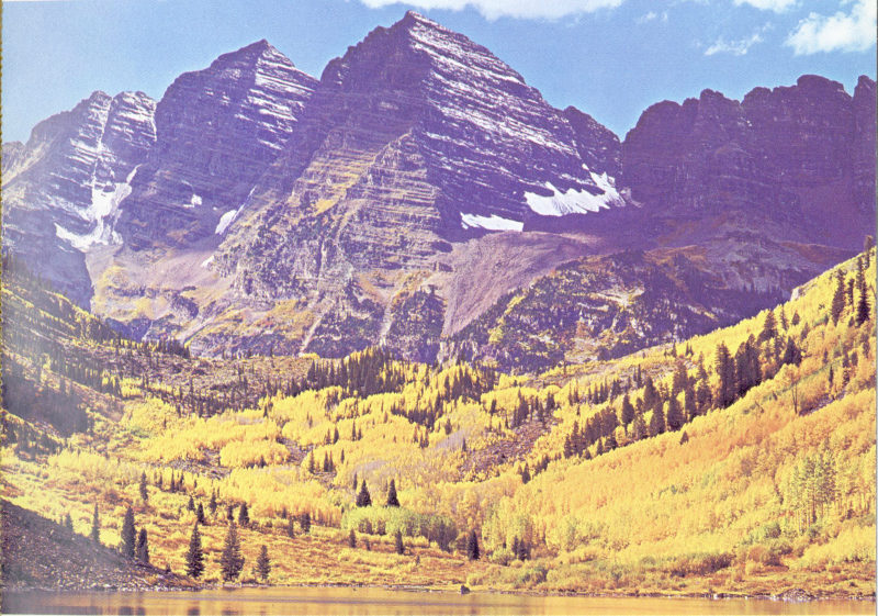
Tilted dark red sedimentary rocks of the Pennsylvanian-Permian Maroon Formation are well exposed in the cliffs of Maroon Bells, southwest of Aspen. (Photo courtesy Hydraulic Unlimited Mfg. Co.)
iii
CONTENTS
Page
Introduction 1
I Colorado’s Three Provinces 3
The Prairies 8
The Peaks 10
Front Range 11
Wet Mountains 16
Sangre de Cristo Range and Spanish Peaks 17
Park Range and Rabbit Ears Range 19
Gore Range 20
Tenmile and Mosquito Ranges 21
Sawatch Range 22
Elk Mountains and West Elk Mountains 24
San Juan Mountains 25
Uinta Mountains 26
The Plateaus 28
II Geologic History of Colorado 32
Precambrian Era 33
Paleozoic Era 38
Cambrian Period 39
Ordovician Period 40
Silurian Period 42
Devonian Period 42
Mississippian Period 43
Pennsylvanian Period 44
Permian Period 48
Mesozoic Era 51
Triassic Period 51
Jurassic Period 52
Cretaceous Period 56
Cenozoic Era 59
Tertiary Period 59
Quaternary Period 68
III Geology and Man in Colorado 74
Gold, Silver, and Other Metals 77
Boulder County 79
Central City and Idaho Springs 80
Georgetown, Empire, and Silver Plume 81
Leadville 82
Breckenridge 83
Fairplay 84
Silverton 85
Ouray 87
Aspen 88
Creede 89
Cripple Creek 90
Climax 91
Radium, Uranium, and Vanadium 93
Oil, Natural Gas, and Oil Shale 94
Coal 96
Construction Materials 97
Sand, Gravel, and Clay 97
Stone 99
Lime and Gypsum 101
Gems 102
Water 103
Surface Water 103
Groundwater 105
Caves 106
Springs 109
Environmental Geology 111
Glossary 114
Suggested Reading 119
Index 121
v
ILLUSTRATIONS
Page
Colorado’s three geologic provinces 2
Pikes Peak, seen from the Garden of the Gods 4
Rock classification (chart) 5
Stratigraphic column (chart) 7
Jurassic rocks in Colorado (map) 9
East face of Longs Peak 11
Rocky Mountain National Park (east-west profile) 12
Big Thompson Canyon, west of Loveland 13
Red Rocks Amphitheater, west of Denver 14
Colorado Springs area (map and cross section) 15
Joint systems in Precambrian rocks, Boulder Canyon 15
Spanish Peaks, southwest of Walsenburg 18
Hahn’s Peak, north of Steamboat Springs 19
Gore Range from the east 20
Aspen Mountain geology (map) 23
Mt. Sopris, south of Glenwood Springs 24
Ouray, in the San Juan Mountains 25
Steamboat Rock, Dinosaur National Monument 27
Grand Hogback, near Rifle (block diagram) 28
Mt. Garfield, near Grand Junction 30
Precambrian-Cambrian unconformity south of Ouray 34
Geologic map of Colorado 35
Black Canyon of the Gunnison National Monument 36
Precambrian-Cambrian unconformity, Glenwood Canyon 38
Cambrian fossils 39
Ordovician fossils 41
Devonian fossils 43
Mississippian fossils 44
Pennsylvanian paleogeography (map) 45
Fountain Formation northwest of Denver 45
Pennsylvanian fossils 46
Contorted Pennsylvanian rocks near Gypsum 46
Balanced Rock, Garden of the Gods 48
Permian reptile tracks 49
The Flatirons, near Boulder 50
Colorado National Monument 51
Morrison Formation, west of Denver 53
Dinosaur bones, found near Morrison 54
Dakota Sandstone hogback 56
Cretaceous fossils 57
Wolford Mountain, north of Kremmling 60
Eohippus, the “Dawn Horse” 61
Golden and South Table Mountain 62
Devil’s Staircase, near Spanish Peaks 63
Green River oil shale, west of Rifle 64
Florissant Fossil Beds National Monument 65
Pawnee Buttes, north of Fort Morgan 66
Fossil mammals, northeastern Colorado 67
Glacial lakes in Rocky Mountain National Park 68
Arapaho Glacier, west of Boulder 70
Pleistocene mastodons 72
Great Sand Dunes National Monument 73
Colorado Mineral Belt (map) 78
Sluicebox mining in early Colorado 81
Early-day Leadville 82
Gold dredge, Fairplay 84
Silverton, in the San Juan Mountains 86
Abrams Mountain, south of Ouray 87
Creede and its mines (map) 89
Cripple Creek, near Pikes Peak 90
Climax molybdenum mine (cross section) 91
Rampart Range quarry, near Colorado Springs 98
Yule Marble quarry, near the town of Marble 99
Lyons Sandstone quarry 100
University of Colorado Museum 100
Colorado-Big Thompson Project (cross section) 103
San Luis Valley (cross section) 105
Cave of the Winds, near Manitou 107
Mesa Verde cave and Indian dwellings 108
Glenwood Hot Springs 109
1