Introduction
Reading edition
Gold was discovered in the bed of the South Platte River in 1858. Prospectors flocked to Colorado as they had flocked only a few years before to California. They worked the sands and gravels of Cherry Creek, Clear Creek, Boulder Creek, and California Gulch. Exhausting the placer sands of the stream bottoms, they moved higher to mine gold-bearing veins at Central City and Blackhawk. Mining camps sprang into existence overnight, each heralding some new “strike,” each populated by a new rush of fortune seekers. As lower areas were mined out, prospectors moved yet higher—to Breckenridge, Gold Hill, and Empire, Aspen, Leadville, and Cripple Creek. Silver was found as well as gold, then iron, and later tungsten and molybdenum. The metallic ring of mining tools echoed from Colorado’s peaks. Fortunes were made here. Legends were born.
Prospectors and miners were not, however, the first people interested in the rocks of Colorado. Earlier, bands of nomadic Cheyenne and Arapaho Indians had searched Colorado’s hills for flint for arrowheads and brightly colored clays for warpaint. Cliff-dwelling Pueblo Indians in southwestern Colorado sought clay for their pottery and fossil seashells for the magic of their medicine men. And from farther to the southwest, Navajo tribesmen came to Colorado for turquoise.
From clay to gold, much of Colorado’s wealth has come from her mountains. But after the rush to the mines, as veins were mined out and placers worked over, as values and prices changed, her population sought the riches of the prairies: fertile lands for agriculture, and in the rock layers below, black gold—vast accumulations of oil and natural gas. The tablelands and plateaus west of the mountains yield their wealth, too. Here are valley farms, fed often by irrigation water, and ranch country. Here is more oil, and in some areas precious metals and uranium.
2
In recent years Colorado’s prairies, peaks, and plateaus have brought new meaning to all America: the state now provides an attractive playground for state residents and their visitors. Campgrounds, streams, lakes, and high trails beckon in summer; barren slopes deep in winter snow attract the skier. More and more, those who live in Colorado and those who visit her seek to understand these mountains and hills and prairies, to learn of her geologic origins and her far distant past. For tourist and resident, casual visitor, ski enthusiast, Sunday picnicker, for all those who have met Colorado and enjoyed her, this book is written.
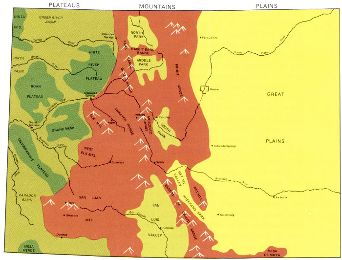
Topographically, scenically, and geologically, Colorado can be divided into the three provinces shown here.
PLATEAUS
UINTA MTS.
GREEN RIVER BASIN
Yampa River
Steamboat Springs
UINTA BASIN
White River
WHITE RIVER PLATEAU
ROAN PLATEAU
Glenwood Springs
Colorado River
Grand Junction
GRAND MESA
Gunnison River
UNCOMPAHGRE PLATEAU
Dolores River
PARADOX BASIN
MESA VERDE
MOUNTAINS
NORTH PARK
RABIT EARS RANGE
PARK RANGE
MIDDLE PARK
GORE RANGE
FRONT RANGE
ELK MTS.
Aspen
SAWATCH RANGE
Leadville
MOSQUITO RANGE
Fairplay
SOUTH PARK
WEST ELK MTS.
Gunnison
Salida
WET MTS.
SANGRE DE CRISTO RANGE
SAN LUIS VALLEY
Rio Grande
Alamosa
SAN JUAN MTS.
Ouray
Silverton
Durango
MESA DE MAYA
PLAINS
Fort Collins
South Platte River
Denver
GREAT PLAINS
Colorado Springs
Arkansas River
WET MT. VALLEY
HUERFANO PARK
La Junta
Walsenburg
3