"Help Save the Great Cahokia Mound"
Reading edition
By C. H. Robinson, Normal, Illinois.
On April 20th, 1913, an enthusiastic party of Bloomington and Normal men made an archaeological expedition to the great Cahokia mound group in Southern Illinois, which is located in Madison and St. Clair counties, about two miles east of the corporate limits of East St. Louis, Illinois. The location is easily accessible by way of the new hard road or by the St. Louis and Collinsville electric system.
The great Cahokia, or better know as Monk's Mound, together with many smaller mounds are located on a 204 acre farm belonging to the Hon. T. T. Ramey's heirs. This farm is situated in the most picturesque and richest part of the famous "American bottoms." Land which is so fertile that even the aborigines raised much with but little effort and which no doubt led to the location and construction here of the largest earth mound ever built by primitive man, the great pyramid of Cheops in Egypt or the Aztec temple mound of Mexico excepted. Monk's mound covers more ground than any pyramid of Egypt. Cheops is but 746 feet square, the Aztec temple of Mexico is 680 feet square, while Monk's mound is 1080 feet by 780 feet and 104 feet high making about 84,000,000 cubic feet of earth.
This mound has never been touched with pick or shovel, although great quantities of archaeological material have been removed from many of the surrounding smaller mounds and cultivated fields, and many fine collections are to be found in both private and public places, taken from this most ancient residence site of a vanquished race.
The variety and nature of material formed around the great Cahokia group clearly indicate that the mound builders or their successors had access to or traded with other tribes or people located at the headquarters of the Mississippi and Missouri Rivers, also on the Gulf of Mexico, and possibly from the Atlantic to the Pacific Oceans, as evidenced by the vast quantities and nature of the material, from which such large varities of implements and ornaments were constructed. For as workmen are known by their chips so here may also be found the evidence of past ages wrought in such material as flint, jasper, pipe stone, granite, agate, galena, obsidian, hematite, copper, quartz, crystal, deep sea conch shells and much other material foreign to this section of the state.
The surrounding cultivated fields are strewn with pottery fragments mingled with which may be found many human bones and implements of the stone age. Here after the heavy spring rains are over may be plowed up many characteristic specimens. Surely in ages past what a mecca this location must have been!
Regarding the shape and size of the great Cahokia mound group it may be said that all types except the effigy are represented here the form of the largest mound is a parallelogram, with straight sides, the longer of which are north and south. On the southern end thirty feet above the base is a terrace or apex, containing two acres of ground. On the western side some thirty feet above the first terrace is a second of some what less extent. The top of the mound is flat, containing about one acre and a half, and is divided into two parts the northern portion of which is some four or five feet higher than the southern portion.
Near the middle of the first terrace, at the base of the mound is a projecting point apparently the remains of a graded pathway ascending from the plain to the terrace. Monk's mound stands true to the exact points of the compass.
There are several conical shaped mounds of about forty feet in height, together with a large number of rectangular shape flat top mounds ranging in size from 20 to 30 feet in height and some of smaller size sufficient to conveniently accommodate a good sized farm house and out buildings. One noticeable exception of this mound group lies just south of the great mound the same being of conical shape except that there are nine radiating ridges extending outward at equal distances from the flattened top. This mound is about fifty feet high with a 150 foot base, the radiating ridges extending outward about ten feet each, just what these radiating ridges symbolize no one knows, possibly the radiating lines of the sun, or the ridges may represent the sacred conch shells found buried here in great numbers.
Monk's mound derived this name from the fact that from 1804 to 1809 a colony of Monks of the order of La Trappe occupied the locality as missionaries among the Cahokia Indians. These monks devoted themselves to silence and seclusion and ate a strictly vegetable diet. They soon succumbed to the malarial influences existing at that time, many died and those remaining returned whence they came, the last of them leaving in March, 1813.
The name Cahokia given the group of mounds is derived from a tribe of Indians met by LaSalle in that vicinity, during his visit there in December, 1681. Growing upon Monk's mound may be seen a pear orchard, set out by the Monks, many of these trees are yet vigorous and bear fruit in season. Besides these fruit trees, there are many fine forest trees, some of which have reached a very large size; all of which tends to make this large mound one of the most picturesque sights in spring, summer and autumn.
Only a short distance to the north of Monk's mound flows Cahokia Creek, its heavily wooded tract of timber giving here a rare chance to the Archaeologist and land-scape artist to help some one of the greatest movements of pre-historic man to be found in the United States today. Ohio has long since made safe her serpent mound, together with many lesser ones by proper legislative acts, other states and counties have protected pre-historic works of much less importance. Why then should the great State of Illinois not preserve our Cahokia group? During the last legislative session at Springfield, Cahokia mound park bills were introduced in both houses and are now known as House Bill No. 176 Flagg, and Senate Bill No. 276 Beall, on June 7, 1913. The matter was refered to the Illinois State Park Commission to investigate the desirability of the state acquiring the Cahokia mound and report to the forty-ninth General Assembly not later than Feb. 1, 1915.
The names and addresses of the members of the Illinois State Board of Park Commissioners are as follows: Alexander Richards, Ottawa, Ill. T. A. James, Evanston, Ill. and Thomas Cahill, Loda, Ill.
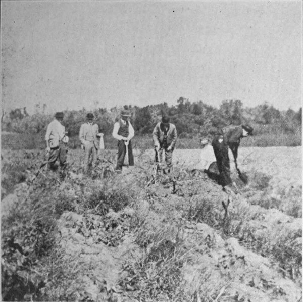
Plate No. 1 At research on Ramey Farm in field near Monk's Mound, October, 1913
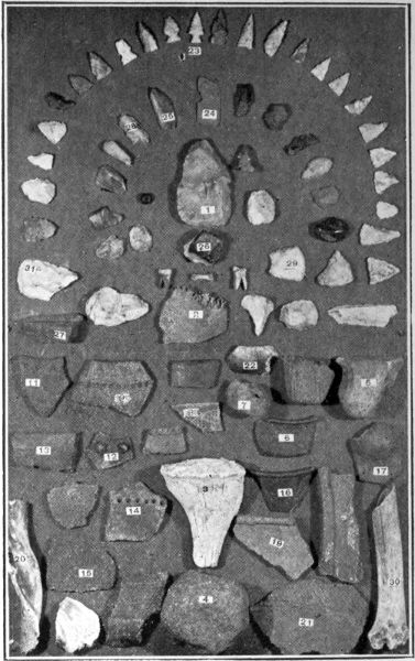
Plate No. 2 Characteristic surface finds from location shown on plate 1.
Cuts furnished by C. H. Robinson
Cahokia Surface Finds, No. 3
Plate No. 2
1. Large arrow point or small flint hoe, length 3 inch
2. Sections of human skull
3. Outer shell of sacred conch shell
4. Perfect shape hammer stone, granite
5. Pottery ear from vessel
6. Potsherd, incised design, color black
7. Pottery, ducks head
8. Pottery, engraved design
9. Potsherd, reed, marked design, color red
11. Potsherd, reed, marked design, color yellow
12. Potsherd, raised, marked design, color black
13. Potsherd, reed, marked design, color red
14. Potsherd, reed, marked design, color brown
15. Potsherd, grass, marked design, color brown
16. Potsherd, incised, marked design, color black
17. Potsherd, raised, marked design, color brown
19. Potsherd, grass, marked design, color yellow
20. Inner spiral of sacred conch shell
21. Potsherd, grass, marked design, color brown
22. Fragment of polished discoidal stone
23. Perfect barbed arrow point 1 inch long, semi-circular row around No. 23, show characteristic Cahokia arrow points
24. Copper ornament
25. Pipestone
26. Agate
27. Gavel sand stone polisher
28. Quartz crystal
30. Pieces of human arm bone
31. Incomplete flint artifacts
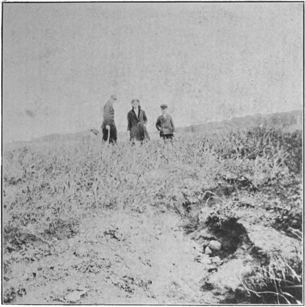
Plate No. 3 West Twin Grove Indian Camp Site on farm of Chas. F. Kauffman, May, 1912
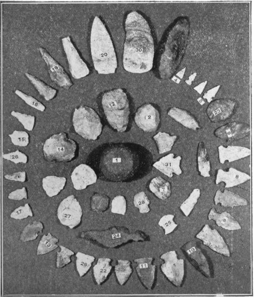
Plate No. 4 Artifacts made by aborigines on Camp Site shown on Plate No. 4
Cuts furnished by C. H. Robinson
West Twin Grove Camp Site
Plate No. 4.
1. Gamestone 2-1/4 (problematical) gray granite
2. Scraper, pink flint
3. Knife 4 inches long, yellow flint, (between 30 and 4)
4. Bird arrow point, 3/4 inches long, white flint
5. Double notched arrow, curved body, white flint
6. Notch of arrow, flat on one side
7. Scraper—mottled blue and white flint
8. Barbed arrow, to remain in wound
9. Non-barbed arrow, to be withdrawn from wound
10. Common chert arrows
11. Red flint arrow
12. Heavy chert arrow
13. Blue flint arrow
14. Rare ceremonial stone, brown flint
15. Drill, white flint
17. Blunt arrow, white flint
18. Drill, white flint
19. Half completed leaf arrow, white flint
20. Finely finished spear point, pink flint
22. Common arrow
23. Perfect shape leaf arrow, blue flint
24. Fragment of pottery, porphyry tempered
25. First piece of arrow found on camp-site
26. Drill, white flint
27. 2/3 completed leaf shape arrow, white flint
28. Perfect hafted scarper, white flint
29. Wide base arrow, white flint
30. Perfect knife, mottled flint, red, white and blue
31. Perfect double bevel arrow, white flint
Through the courtesy of the Ramey Family, the writer and party were given much valuable data and information pertaining to the early history of this historic spot, therefore honorary mention is herewith given to the sturdy and honest pioneer, the late T. T. Ramey, who was one of the few successful 49er's. Returning east again, he invested his hard earned gold in the rich alluvial "American bottom" lands of Madison County and upon which now stands the great Cahokia mound, together with twenty others of lesser magnitude. He was a close student of both God and man. He soon conceived the idea that the large mound should never be disturbed and if possible become the property of the state. Thus he kept in tact this great earthwork during his lifetime and it is with the same spirit that his children do likewise.
May we not hope that the State of Illinois shall in due time make this great mound group a state preserve and keep intact the great Cahokia Mound just as the Ramey family have done for many years?
The party making the Cahokia trip was composed of Milo Custer, G. Blumke, Mark Piper, S. W. Le Neve, Herbert Cox and the writer.
Charles M. Robinson.