JOURNAL.
Reading edition
A Journal of my Journey over the Mountains began Fryday the 11th of March 1747-8.[1]
Fryday March 11th 1747-8. Began my Journey[2] in Company with George Fairfax, Esqr.;[3] we travell'd this day 40 Miles to Mr George Neavels[4] in Prince William County.[5]
Saturday March 12th this Morning Mr James Genn ye surveyor[6] came to us, we travel'd over ye Blue Ridge[7] to Capt Ashbys[8] on Shannondoah River,[9] Nothing remarkable happen'd.
Sunday March 13 Rode to his Lordships Quarter[10] about 4 Miles higher up y River we went through most beautiful Groves of Sugar Trees & spent ye best part of y Day in admiring ye Trees & richness of ye Land.
Monday 14th We sent our Baggage to Capt Hites[11] (near Frederick Town)[12] went ourselves down ye River about 16 Miles to Capt Isaac Penningtons (the Land exceeding Rich & Fertile all ye way produces abundance of Grain Hemp Tobacco &ca) in order to Lay of some Lands on Cates Marsh & Long Marsh.[13]
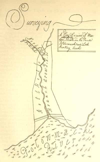
Surveying A Plan of a piece of Meadow called Hell Hole Situate on the River Potowmack near Little Hunting Creek
Tuesday 15th We set out early with Intent to Run round ye sd Land but being taken in a Rain & it Increasing very fast obliged us to return, it clearing about one oClock & our time being too Precious to Loose we a second time ventured out & Worked hard till Night & then return'd to Penningtons we got our Suppers & was Lighted into a Room & I not being so good a Woodsman as ye rest of my Company striped myself very orderly & went in to ye Bed as they called it when to my Surprize I found it to be nothing but a Little Straw—Matted together without Sheets or any thing else but only one thread Bear blanket with double its Weight of Vermin such as Lice Fleas &c[14] I was glad to get up (as soon as y Light was carried from us) I put on my Cloths & Lays as my Companions. Had we not have been very tired I am sure we should not have slep'd much that night I made a Promise not to Sleep so from that time forward chusing rather to sleep in y. open Air before a fire as will appear hereafter.
March y. 15th 1747-8 Survey'd for George Fairfax Esqr. a Tract of Land lying on Cates Marsh and Long Marsh Begining at three Red Oaks Fx on a Ridge the No Side a Spring Branch being corner to ye 623 Acre Tract & Extending thence No 30° Et 436 poles to a Large Hickory and Red Oak Fx near John Cozines house thence No 60° Wt 90 Poles to a Large White Oak Fx thence No 7° Et 365 poles to Long Marsh 420 poles to 2 Red Oaks and W: Oak in a Poyson'd field[15] by a Road thence No 65° Wt 134 Poles to a W: Oak by ye sd Marsh thence crossing ye Marsh So 20° Wt 126 poles to another Branch: of Long Marsh 218 poles to a Red Oak Fx thence No 80° Wt 558 po: to a Large Red Oak & White Oak Fx in a Valley thence S 25° Wt 144 poles to a Black Walnut in a Poysond Field by a Lime stone Rock thence So 33½° Et 96 to a White Oak thence So 20 Et 316 po. to three Red Oaks in a Bottom in Wm Johnstones line thence with Johnstones So 80° Et 30 po to a Double Hickory Collo Blackburns corner 114 po to 3 Hickorys Johnstones corner & corner to ye aforesd 623 Acre Tract thence along ye lines thereof East 280 poles to 3 Red Oaks finally along another of the lines thereof S 15° Et 262 po. to ye beginning
Henry Ashby}Chainmen.
Richard Taylor}
Robert Ashby Marker.
Wm Lindsy Pilot.
Wednesday 16th We set out early & finish'd about one oClock & then Travell'd up to Frederick Town where our Baggage came to us we cleaned ourselves (to get Rid of y. Game[16] we had catched y. Night before) & took a Review of y. Town & thence return'd to our Lodgings where we had a good Dinner prepar'd for us Wine & Rum Punch[17] in Plenty & a good Feather Bed[18] with clean Sheets which was a very agreeable regale.
Thursday 17th Rain'd till Ten oClock & then clearing we reached as far as Major Campbells one of there Burgesses about 25 Miles from Town. nothing Remarkable this day nor Night but that we had a Tolerable good Bed lay on.
Fryday 18th We Travell'd up about 35 Miles to Thomas Barwicks on Potomack[19] where we found y. River so excessively high by Reason of y. Great Rains that had fallen up about y. Allegany Mountains as they told us which was then bringing down y. melted Snow & that it would not be fordable for severall Days it was then above Six foot Higher than usual & was rising we agreed to stay till Monday we this day call'd to see y. Fam'd Warm Springs[20] we camped out in y. field this Night Nothing Remarkable happen'd till sonday y. 20th
Sonday 20th finding y. River not much abated we in y. Evening Swam our horses over & carried them to Charles Polks in Maryland for Pasturage till y. next Morning.
Monday 21st We went over in a Canoe & Travell'd up Maryland side all y. Day in a Continued Rain to Collo Cresaps[21] right against y. Mouth of y. South Branch[22] about 40 Miles from Polks I believe y. worst Road that ever was trod by Man or Beast.
Tuesday 22d Continued Rain and y. Freshes kept us at Cresaps.
Wednesday 23d Rain'd till about two oClock & Clear'd when we were agreeably surpris'd at y. sight of thirty odd Indians coming from War with only one Scalp[23] We had some Liquor with us of which we gave them Part it elevating there Spirits put them in y. Humour of Dauncing of whom we had a War Daunce[24] there manner of Dauncing is as follows Viz They clear a Large Circle & make a Great Fire in y. middle then seats themselves around it y. Speaker makes a grand Speech telling them in what Manner they are to Daunce after he has finish'd y. best Dauncer Jumps up as one awaked out of a Sleep & Runs & Jumps about y. Ring in a most comicle Manner he is followed by y. Rest then begins there Musicians to Play ye Musick is a Pot half of Water with a Deerskin Streched over it as tight as it can & a goard with with some Shott in it to Rattle & a Piece of an horses Tail tied to it to make it look fine y. one keeps Rattling and y. other Drumming all y. while y. others is Dauncing
Fryday 25th 1748 Nothing Remarkable on thursday but only being with y. Indians all day so shall slip it this day left Cresaps & went up to y. mouth of Patersons Creek[25] & there swam our Horses over got over ourselves in a Canoe & traveld up y. following Part of y. Day to Abram Johnstones 15 Miles from ye Mouth where we camped.
Saterday 26 Travelld up ye Creek to Solomon Hedges Esqr one of his Majestys Justices of ye Peace for ye County of Frederick where we camped when we came to Supper there was neither a Cloth upon ye Table nor a Knife to eat with but as good luck would have it we had Knives of own.[26]
Sunday 27th Travell'd over to y. South Branch attended with y. Esqr to Henry Vanmetriss[27] in order to go about Intended Work of Lots[28]
Monday 28th: Travell'd up y Branch about 30 Miles to Mr James Rutlidges[29] Horse Jockey & about 70 Miles from ye Mouth
Tuesday 29th This Morning went out & Survey'd five Hundred Acres of Land & went down to one Michael Stumps on ye So Fork of ye Branch on our way Shot two Wild Turkies[30]
March 29th: 1748 Survey'd for Mr James Rutlidge ye following a piece of Land Beginning at 3 W. O. in ye Mannor Line[31] by a Path leading to y. Clay Lick[32] & Extending thence No 44° Wt 164 po. to a White Oak by a Drain at ye foot of a Mountain thence No 46° Et 487 po. to 2 White Oaks near a Branch call'd Clay Lick Run thence So 44° Et 164 po. to 2 W: O: & a Hickory in ye Mannor line Finally along ye Mannor line Reversed So 46° Wt 487 po to y. Beginning
Henry Ashby}Chainmen
Richard Taylor}
Wm Duncan Marker
Wednesday 30th This Morning began our Intended Business of Laying of Lots we began at ye Boundary Line of ye Northern 10 Miles above Stumps & run of two Lots & returnd to Stumps
The Courses & Distances of ye Several Lots lay'd of on ye So Fork of Wappacomo[33] Began March 30th. 1748
Lot ye 1st Peter Reeds Begins at a Box Oak & Hickory F in y. Boundary line about 20 po. above a Large Spring on ye West side ye Fork in a Hollow of ye Mountains and extending thence No 65° Et 320 Po. to a White O: and Hickory on ye Mountain side thence So 60° Et 300 Po: Crossing ye Fork at 106 P: to 2 Spanish Oaks and W: O on ye Top of a Hill thence So 65 Wt 96 to a White Oak on ye Top of a Hill thence So 45 Wt 114 po. to a W: O on a Run thence So 13 Wt 148 to a Pine thence S 45° Wt 28 po. to 2 R == O: bushes in ye Boundary line thence along y. same to ye Beginning
Lot the 2d Begins at a W: O & Hickory on a Mountain side Corner to Lot ye 1st extending ye Line So 60° Et 300 po. to 2 Spanish Oaks and W: O on a Hill thence No 30′ Et 214 po to 2 W: O near a Branch thence No 60° Wt 244 po to y. So Fork 300 po. to a Ledge of Rocks on a Mountain side thence So 30 Wt 214 to ye Beginning.
Thursday 31st Early this Morning one of our Men went out with ye Gun & soon Returnd with two Wild Turkies we then went to our Business run of three Lots & returnd to our Camping place at Stumps
March 31st
Lot the 3d Begins at Ledge of Rocks corner to Lot 2d extendth thence along ye sd line So 60 Et 300 po to 2 W: O near a Branch thence No 30 Et 214 po to a Pine on a Hillside near a Run thence No 60° Wt 78 to y. Bottom Ground 202 po. to ye River and 244 po. to a Pine by a Rock on y. Mountain side thence to ye Beginning S. 30 Wt 224 P.
Lot 4th this Lot survey'd myself Beginning at a Pine by a Rock on a mountain side Corner to Lot 3d & Running the sd line So 60° 244 Poles to a Pine on a Hill side near a Run thence No 30° Et 262 Po to 2 Chesnut Oaks and a Pine thence No 60° Wt 98 Pole to ye Low Grounds 164 to ye Fork and 244 P. to a R: O on a Rock thence So 30 Wt 262 Po to y. Beginning
Lot 5th Begins at a Red O on a Rock Corner to Lot 4th & extendeth thence So 60 Et 244 Poles to 2 Chesnut Oaks & a Pine thence No 30 Et 262 Po. to a W: O by a Run thence No 60 Wt 154 po to an ash 108 po to ye Fork thence No 86 Wt 38 xing ye Fork 78 xing it again and 100 Po: to a R: O on ye mountain Side thence S 30 Wt 262 Po to ye Begg
[April 1st]
Lot ye 6th Anthony Regar Begins at a Red Oak on a Mountain side Corner to Lot ye 5th and extending thence along ye sd Line So 86 Et 100 po. to an Ash thence with another of ye sd lines So 60 Et 154 po: to a white Oak by a Run thence No 30 Et 256 po to 3 pines on a Hill side thence No 60 Wt 200 po: to ye Low Grounds 320 po to a Poplar standing in ye Fork thence to ye Begg
Lot ye 7th Harmon Shoker & Elias Cellars Begins at a Poplar standing on ye So Fork Corner to Lot ye 6th & Running along ye Line So 60 Et 244 po to a Pine on a Hill side thence N 30 Et 262 po by 2 Marked Pines thence No 60 Wt 46 po to ye Low G: 140 to ye Fork and 244 po to a Stone on ye side of a Mountain thence to ye Beging S 30 Wt
Lot ye 8th Vacant[34] Beginning at a Rock corner to lot 7 & Running along ye Line thereof So 60 Et 244 po by 2 Pines thence No 35 Et 266 po. to 3 Chesnut Oaks on a Steep Hill side thence No 55 Et 54 po. to ye Low Grounds 80 po. to ye Fork 190 po to ye farr Edge of ye Low G: 244 po. to a Chesnut Oak on ye Mountain side thence to ye Begining
Fryday April ye 1st 1748 This Morning Shot twice at Wild Turkies but killd none run of three Lots & returned to Camp
Saterday April 2d Last Night was a blowing & Rainy night Our Straw catch'd a Fire yt we were laying upon & was luckily Preserv'd by one of our Mens awaking when it was in a we run of four Lots this Day which Reached below Stumps
April 2d
Lot ye 9th
Begining at Chesnut Oak on ye Mountain side corner to Lot 8th & Running along ye Line thereof So 55 Et 244 po to 3 Chesnut Oaks on a Steep Side thence No 35 Et 262 po to 2 Chesnut Oaks & a White Oak thence No 65 Et 80 to ye Low G: 126 po to ye Fork 244 po to a Hickory at ye Foot of the Mountain thence to ye Beginning So 35 Wt 262 po this Lot is very Good
Lot 10th Michael Calb Liveron Begining at a Hickory Corner to Lot ye 9th & Runing along ye Line So 55 Et 244 Pole to 2 Chesnut Oaks thence No 35 Et 262 po to 2 pines & a spanish Oak on ye Top of a Hill thence No 55 Wt 84 po to ye Low G: 230, po to ye Fork 270 po to a Red O: on ye Mountain Side thence to ye Beginning
Lot ye 11th Leonard Nave Beginning at a Red O: on ye Mountain side Corner to Lot ye 10th & Running along ye Line S 55 Et 270 Po to 2 Pines on ye Top of a Hill thence No 35 Et 262 po. to a Pine on a Hill side thence No 55 E 180 po to ye Bottom 248 po to ye Fork 274 to an Ash at ye Foot of ye Mountain thence to ye Beg.
Lot 12th Michael Stumps Begins at an Ash at ye Foot of ye Mountain Corner to Lot 11 & Running along ye Line So 55 Et 274 Po: to a Pine thence No 25 Et 320 po to 2 Pines thence No 65 Wt 188 po to ye Low G: 280 po to 2 Sycamores & a White Wood tree Standing on ye Fork thence up and Crossing ye Fork to ye Begg
Sunday 3d Last Night was a much more blostering night than ye former we had our Tent Carried Quite of with ye Wind and was obliged to Lie ye Latter part of ye night without covering there came several Persons to see us this day one of our Men Shot a Wild Turkie
Monday 4th this morning Mr Fairfax left us with Intent to go down to ye Mouth of ye Branch we did two Lots & was attended by a great Company of People Men Women & Children that attended us through ye Woods as we went showing there Antick tricks I really think they seem to be as Ignorant a Set of People as the Indians they would never speak English but when spoken to they speak all Dutch[35] this day our Tent was blown down by ye Violentness of ye Wind
April 4d
Lot ye 13 Vacant Begins at 2 Sycamores and a White Wood Tree standing on ye fork Corner to Lot 12th & Running along ye Line So 65 Et 280 po. to 2 pines thence No 25 Et 228 Po. to a Spanish Oak thence No 65 Wt 206 to ye Low G: 248 po to ye Fork 280 to a Rock Stone on ye Mountain Side thence to the Beginning S 25 Wt 228 poles
Lot 14th James Simson's Begins at a Rock Stone on ye Mountain Side Corner to Lot ye 13th & Runs thence So 65 Et 280 pole to a Spanish Oak thence No 25 Et 228 pole to a Large Hickory in a Vally thence No 65 Wt 108 to ye Low G: 180 pole to ye Fork 280 pole to 3 Red Oaks on ye Mountain side near a Spring Branch thence to ye Beginning S 25 Wt 228 pole this Lot I survay'd.
The Courses of ye Fork from Lot 14th Down to ye Mannor Line Beginning at 2 Red Bud Trees[36] & a Black Walnut on ye West side ye Fork & Running Down ye Several Courses of ye Fork No 9 Et 19 po No 34 Wt 12 po No 15 Et 22 po No 39 Et 24 po No 12 Et 23 po No 17 Wt 66 po N 6 Et 42 po opposite to Henry Harris's house No 26 Wt 20 po West 32 op Phillip Moors house bears No 86 Wt No 23 Wt 48 po to a Blazed Tree[37] from here Phillip Moors house bears So 54 Wt No 6 Wt 33 po No 28 Et 26 po No 73 Et 28 po No 7 Wt 85 po to a blazed tree No 45 Wt 24 po. ye Widow Wolfs[38] house bears So 52 Wt about 60 po. No 65 Wt 27 po So 84 Wt 18 po. S 50 Wt 14 po S. 19 W 20 po No 67 Wt 22 po. No 28 Wt 23 po. So 78 Wt 29 po No 71 Wt 25 po. No 39 Wt 19 po No 3 Wt 24 po. xx No 60 Wt 20 po No 39 Wt 20 po No 8 Et 46 po to an Ash black Walnut & White Walnut in ye Mannor Line on ye sd fork thence So 36 Wt along ye Mannor Line 320 poles to 2 W: O & a R: O.
Tuesday 5th We went out & did 4 Lots we were attended by ye same Company of People yt we had ye day before
April ye 5th 1748
Lot ye 15th Phillip Moore Beginning at Lot ye 14th on ye Fork & Running down ye Meanders to ye first Blazed Tree a Black Oak on ye Fork thence So 69 Wt 80 to ye Edge of ye Low G: 226 po to a Spanish Oak thence So 41 Et 296 po. to a White Oak on a Mountain side thence No 40 Et 38 po to 3 Red Oaks on a Mountain side near a Spring Branch this Lot very good
Lot ye 16th and 17th Widow Wolfs and Henry Sheplars a Black Smith by trade Begins at a Black Walnut on ye Fork & Runs So 17 W 76 po to a Red Oak & Hickory 90 po Crossing ye Road about 20 po: above ye house 226 po to 2 W: O thence No 41 Wt 96 po to 2 White Oaks in ye Mannor line to ye River the line of ye 16th Lot from ye 2 W: O S 41 Et
Lot 18th Jeremiah Osborne's Begins at a Sycamore on ye Fork & extending No 80 Et 215 po. to a Chesnut Oak thence South 280 po to a W: O near a Hickory Corner to Lot ye 14th thence along the line thereof to ye Fork thence down ye Several Meanders of ye Fork to ye Beginning
Wednesday 6th Last Night was so Intolerably smoky that we were obliged all hands to leave ye Tent to ye Mercy of ye Wind and Fire this day was attended by our afored Company untill about 12 oClock when we finish'd we travell'd down ye Branch to Henry Vanmetris's on our Journey was catch'd in a very heavy Rain we got under a Straw House untill ye Worst of it was over & then continued our Journey
April 6th
Lot 19 Begg: at a Spanish Oak corner to Lot 18th & Runing thence No 23 Wt 350 po to 3 W: O thence So 36 Wt 164 po 94 to ye Low G: to 2 Locust Trees on ye Fork
Lot ye 20th Begg at 2 Locusts on ye Fork Corner to Lot 19th & Runing along ye Line No 36 Et 164 po to 3 W: O thence No 23 Wt 250 po 3 Red Oaks in ye Manner line thence Down ye Manner line
Thursday 7th Rain'd Successively all Last night this Morning one of our men Killed a Wild Turkie that weight 20 Pounds we went & Survey'd 15 Hundred Acres of Land & Return'd to Vanmetris's about 1 o'Clock about two I heard that Mr Fairfax was come up & at 1 Peter Casseys about 2 Miles of in ye same Old Field[39] I then took my Horse & went up to see him we eat our Dinners & walked down to Vanmetris's we stayed about two Hours & Walked back again and slept in Casseys House which was ye first Night I had slept in a House since I came to ye Branch
Fryday 8th we breakfasted at Casseys & Rode down to Vanmetris's to get all our Company together which when we had accomplished we Rode down below ye Trough in order to Lay of Lots there we laid of one this day The Trough is couple of Ledges of Mountain Impassable running side & side together for above 7 or 8 Miles & ye River down between them you must Ride Round ye back of ye Mountain for to get below them we Camped this Night in ye Woods near a Wild Meadow where was a Large Stack of Hay after we had Pitched our Tent & made a very Large Fire we pull'd out our Knapsack in order to Recruit ourselves every was his own Cook our Spits was Forked Sticks our Plates was a Large Chip as for Dishes we had none
Saterday 9th Set ye Surveyor[40] to work whilst Mr Fairfax & myself stayed at ye Tent our Provision being all exhausted & ye Person that was to bring us a Recruit disappointing us we were oblige to go without untill we could get some from ye Neighbours which was not till about 4 or 5 oClock in ye Evening we then took our Leaves of ye Rest of our Company Road Down to John Colins in order to set off next Day homewards
Sunday 10th We took our farewell of ye Branch & travell'd over Hills and Mountains to 1 Coddys on Great Cacapehon about 40 Miles
Monday 11th We travell'd from Coddys down to Frederick Town where we Reached about 12 oClock we dined in Town and then went to Capt Hites & Lodged
Tuesday 12th We set of from Capt. Hites in order to go over Wms Gap[41] about 20 Miles and after Riding about 20 Miles we had 20 to go for we had lost ourselves & got up as High as Ashbys Bent[42] we did get over Wms Gap that Night and as low as Wm Wests in Fairfax[43] County 18 Miles from ye Top of ye Ridge This day see a Rattled Snake ye first we had seen in all our Journey
Wednesday ye 13th of April 1748
The Mannor how to Draw up a Return when Survey'd for His Lordship or any of ye Family
March ye 15th 1747-8
Then Survey'd for George Fairfax Esqr. Three Thousand & twenty Three Acres of Land lying in Frederick County[46] on Long Marsh Joyning Thomas Johnstones Land and bounded as follows
Beginning at (A) Three Hickorys Corner Trees to Thomas Johnstones Land & Extending thence along his S 13 Wt One Hundred Seventy two Poles to (B) a Locust Johnstones Corner thence along another of his Lines S 34 Et 150 po. to (C) a White Oak another of his Corners thence So 75 Et 186 po & to (D) a large Hickory thence No 58 Et 160 po xing a Spring Run to (E) three Red Oak Fx on a Ridge thence No 30 Et 436 po to a Hickory an Red Oak Fx at (F) thence No 60 Wt 90 po to (G) a Large White Oak Fx thence No 7 Et 420 po xing Long Marsh to (H) two Red Oaks and a W: O: Fx in a Bottom in ye aforesd Thomas Johnstones line finally along his line So 80 Et one Hundred fourteen Poles to ye Beginning Containing Three Thousand & twenty three Acres.
pr James Genn
Henry Ashby}Chain men
Richard Taylor}
Robert Ashby Marker.
Wm. Lindsey Pilot.
N. B. The Distances in ye above Writing ought to be Written in Letters not in figures only I have done it now for Brevity sake[47]
The Courses & Distances of the Following Plat is as follows viz beginning at A and running thence No 30 Et 436 poles thence N 60 Wt 90 pole thence No 7 Et 365 pole to Long Marsh & 420 to the end of the Course thence N 65 Wt 134 pole thence So 20 Wt 126 poles crossing Long Marsh to a Branch thereof commonly calld Cates Marsh 218 pole to the end of the Course thence N 80 Wt 558 pole thence S 25 Wt 144 pole thence S 33½ Et 96 pole S 20 Et 316 pole thence S 80 Et 114 pole thence East 280 pole thence S 15 Et 262 to the Beginning Survey'd by
James Genn
The Courses of the Town of Alexandria[48]
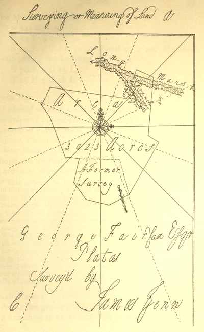
Surveying or Measuring of Land
The Meanders of the River
S 84½ Et 3 Chain S 52 Et 4 C 17 L S 24 E 5 C 9 L to the Point at a sml Hickory stump above the Landing Place S 70 E 1 C 25 L S 45 E 3 C 18 L
Dear Sir
I should receive a Letter or Letters from you by the first and all oppertunetys with the greatest sense or mark of your esteem and affection whereas its the greatest Pleasure I can yet forsee of having in fairfax to hear from my Intimate friends and acquaintances I hope you in Particular will not Bauk me of what I so ardently Wish for[49]
Dear Friend John[50]
As its the greatest mark of friendship and esteem you can shew to an absent Friend In often Writing to him so hope you'l not deny me that Favour as its so ardently wish'd and desired by me its the greatest pleasure I can yet forsee of having in fairfax to hear from my friends Particularly yourself was my affections disengaged I might perhaps form some pleasures in the conversasion of an agreeable Young Lady as theres one now Lives in the same house with me but as that is only nourishment to my former affecn for by often seeing her brings the other into my remembrance whereas perhaps was she not often & (unavoidably) presenting herself to my view I might in some measure eliviate my sorrows by burying the other in the grave of Oblivion I am well convinced my heart stands in defiance of all others but only she thats given it cause enough to dread a second assault and from a different Quarter tho I well know let it have as many attacks as it will from others they cant be more fierce than it has been I could wish to know whether you have taken your intended trip downwards or not if you with what Success as also to know how my friend Lawrence drives on in his art of courtship as I fancy you may both nearlly guess how it will respectively go with each of you
Dear Friend Robin
As its the greatest mark of friendship and esteem absent Friends can shew each other in Writing and often communicating their thoughts to his fellow companions makes me endeavour to signalize myself in acquainting you from time to time and at all times my situation and employments of Life and could Wish you would take half the Pains of contriving me a Letter by any oppertunity as you may be well assured of its meeting with a very welcome reception my Place of Residence is at present at His Lordships where I might was my heart disengag'd pass my time very pleasantly as theres a very agreeable Young Lady Lives in the same house (Colo George Fairfax's Wife's Sister[51]) but as thats only adding Fuel to fire it makes me the more uneasy for by often and unavoidably being in Company with her revives my former Passion for your Low Land Beauty[52] whereas was I to live more retired from yound Women I might in some measure eliviate my sorrows by burying that chast and troublesome Passion in the grave of oblivion or etarnall forgetfulness for as I am very well assured thats the only antidote or remedy that I ever shall be releivd by or only recess that can administer any cure or help to me as I am well convinced was I ever to attempt any thing I should only get a denial which would be only adding grief to uneasiness
Dear Sally
This comes to Fredericksburg fair in hopes of meeting with a speedy Passage to you if your not there which hope you'l get shortly altho I am almost discouraged from writing to you as this is my fouth to you since I receiv'd any from yourself I hope you'l not make the Old Proverb good out of sight out of Mind as its one of the greatest Pleasures I can yet foresee of having in Fairfax in often hearing from you hope you'l not deny it me
I Pass the time of much more agreeabler than what I imagined I should as there's a very agreeable Young Lady lives in the same house where I reside (Colo George Fairfax's Wife Sister) that in a great Measure cheats my sorrow and dejectedness tho not so as to draw my thoughts altogether from your Parts I could wish to be with you down there with all my heart but as it is a thing almost Impractakable shall rest myself where I am with hopes of shortly having some Minutes of your transactions in your Parts which will be very welcomely receiv'd by Your
Dear Sir—It would be the greatest Satisfaction
Memorandom[53] to have my Coat made by the following Directions to be made a Frock with a Lapel Breast the Lapel to Contain on each side six Button Holes and to be about 5 or 6 Inches wide all the way equal and to turn as the Breast on the Coat does to have it made very Long Waisted and in Length to come down to or below the bent of the knee the Waist from the armpit to the Fold to be exactly as long or Longer than from thence to the Bottom not to have more than one fold in the Skirt and the top to be made just to turn in and three Button Holes the Lapel at the top to turn as the Cape of the Coat and Bottom to Come Parrallel with the Button Holes the Last Button hole in the Breast to be right opposit to the Button on the Hip[54]
Dear Richard
The Receipt of your kind favour of the 2d of this Instant afforded me unspeakable pleasure as I am convinced I am still in the Memory of so Worthy a friend a friendship I shall ever be proud of Increasing you gave me the more pleasure as I receiv'd it amongst a parcel of Barbarians and an uncooth set of People the like favour often repeated would give me Pleasure altho I seem to be in a Place where no real satis: is to be had since you receid my Letter in October Last I have not sleep'd above three Nights or four in a bed but after Walking a good deal all the Day lay down before the fire upon a Little Hay Straw Fodder or bearskin whichever is to be had with Man Wife and Children like a Parcel of Dogs or Catts & happy's he that gets the Birth nearest the fire there's nothing would make it pass of tolerably but a good Reward a Dubbleloon is my constant gain every Day that the Weather will permit my going out and some time Six Pistoles[55] the coldness of the Weather will not allow my making a long stay as the Lodging is rather too cold for the time of Year I have never had my Cloths of but lay and sleep in them like a Negro except the few Nights I have lay'n in Frederick Town.
Mem To Survey the Lands at the Mouth of Little Cacapehon[56] & the Mouth of Fifteen Mile Creek[57] for the Gentlemen of the Ohio Com:[58]
I heartily congratulate you[59] on the happy News of my Brothers safe arrival in health in England and am joy'd to hear that his stay is likely to be so short I hope you'll make Use of your Natural Resolution and contendness as they are the only Remedys to spend the time with ease & pleasure to yourself I am deprived of the pleasure of waiting on you (as I expected) by Ague and Feaver which I have had to Extremety since I left which has occasioned my Return D
Memorandom to charge Mrs Aus. Washington[60] with 4 /9 and 18d the 30 of July to a Maryland Hen-wife as also Major Law: Washington with 1 /3 lent the 15 of August 5 /9 the 17 Do 2 /6 Do: I read to the Reign of K: John
In the Spectators Read to No 143[61] Mem:
When I see my Brother Austin to Enquire of him whether He is the Acting Attorney for my Brother and as my Brother Lawrence left Directions with the H. on W Fx[62] to remit his Pay as Agetant whether it would not be more proper to keep it to Pay the Notes of Hand thats Daily coming against him and to Write Word to Williamsburg to Acquaint his Hon: my B: A: to write him word.
Memorandam of what Cloths I Carry into Fairfax
Razor[63] 7 Shirts 2 Do Carrd by Mr Thornton[64] 6 Linnen Waistcoats 1 Cloth Do—— 6 Bands[65] 4 Neck Cloths[66] 7 Caps[67]——
M: the regulater of my watch now is 4 M: and over the fifth from the Slow end
'Twas Perfect Love before}s: Young M: A: his W
But Now I do adore}
What's the Noblest Passion of the Mind? 6:2:
M: Delivered Mrs Humphras this 30th Day of October 2 Shirts the one marked G W the other not marked 1 pr of Hoes & one Band to be Washed against November Court in Frederick[68]
Oh Ye Gods why should my Poor Resistless Heart Stand to oppose thy might and Power At Last surrender to cupids feather'd Dart And now lays Bleeding every Hour For her that's Pityless of my grief and Woes And will not on me Pity take He sleep amongst my most inveterate Foes And with gladness never wish to wake In deluding sleepings let my Eyelids close That in an enraptured Dream I may In a soft lulling sleep and gentle repose Possess those joys denied by Day From your bright sparkling Eyes, I was undone; Rays, you have; more transparent than the Sun, Amidst its glory in the rising Day, None can you equal in your bright array; Constant in your calm and unspotted Mind; } Equal to all, but will to none Prove kind, } So knowing, seldom one so Young, you'l Find. } Ah! woe's me, that I should Love and conceal } Long have I wish'd, but never dare reveal, } Even though severely Loves Pains I feel: } Xerxes that great, was't free from Cupids Dart, And all the greatest Heroes, felt the smart.[69]
A List of the Peoples Names that I have Warrants for[70]
Acres
Richard Arnold Frederick C400
before the 25th Day of April
Barnaby McKannaryDo400
on the Lost River[71]
Silvenus SmithDo400
John WiltonDo300
James McKoyDo400
James KinsonDo400
Ann Dunbarr400
Andw Vincy of Augusta400
Robert DentonDo400
John Stackhouse of Fredk400
Saml KinsmanDo400
Thos WiggansDo400
George HornerDo200
Darby McKeaverDo400
Josh Howt: frm New EngDo400
Jno Ellwick Senr of Augusta400
James Hamilton Jr400
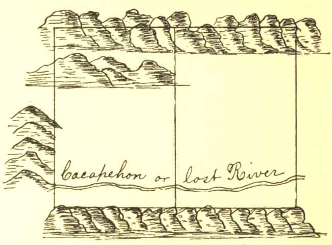
Cacapehon or lost River
My Lord
I went Last Tuesday not knowing your Lordship had that very Day set out for Neavils to see whether you had any further Commands or directions to give concerning the Surveying of Cacapehon and as your Lordship was not at Home I was inform by Colo G. Fairfax that you had not any Directions in Particular more than were given to the other Surveyors as your Lordship had mentioned I therefore have made bold to Proceed on General Directions from him as Missing this Opportunity of Good Weather may be of considerable Hindrance I shall Wait on your Lordship at Frederick Court in November to obey your further Pleasure and am my Lord &[72]
Then Survey'd for Mr John Monroe ye following Tract of land bounded as follows
Poles
ABeginning at a marked white oak}N 20,,0E 130,,68
BN 20—00 E to a Chesnut}
CThence to a Red oakN 71,,00E 116,,44
DThence to a Spanish oak near a SwampS 73,,00E 188,,24
EThence to HiccoryS 44,,00E 158,,72
FThence to a red oak StumpS 14,,00E 186,,24
GThence to a Black GumS 88,,00W 244,,00
From thence to the Beginning
Then survey'd for Mr John Watts ye Following Tract of Land bounded as followeth
Courses
ABeginning at a Marked red Oak}S 15° 30′W 400.56
BS 15° 30 W to a Sweet Gum}
CThence to a ChesnutS 59,,00W 200.40
DThence to a WalnutN 45,,00W 240.24
EThence to a White OakN 10,,00E 200.00
FThence to a MapleN 35,,00E 300.00
From thence to the Beginning
Then Survey'd for Mr Francis Jett the following Tract of Land bounded as follows
ABeginning at a Marked Hiccory S 20, W}S 20,,00W120
Bto a White Oak}
CThence to a Walnut StumpS 63,,00W160
DThence to a Red Oak on the top of a HillS 85,,00W80
EThence to a Black Gum near a ValleyN 66,,00W116
FThence to a Dogwood near a SwampN 35,,00W63
GThence to a Mulberry standing in Corn-fieldN 35,,00E97
HThence to a SasafrasN 45,,00E157
From thence to the Beginning
Then Survey'd for Capt Henry Washington ye following Tract of Land bounded as follows
Poles
ABeginning at a red Oak S 25—00 W}25—00W74
Bnear the road running to a red Oak Saplin}
CThence to white OakS 23—00E24
DThence to Spanish OakS 55—00W34
EThence to a Black GumN 76—00W30
FThence to a Black OakN 25—00W62
GThence to Caleb Butlers old FieldN 00—00W104
HThence to a White OakS 76—00E70
IThence to a Red OakN 78—00E56
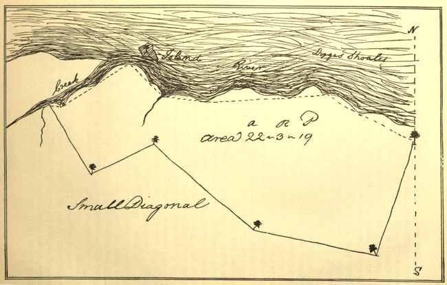
August 18th 1747 Then survey'd the following Piece of Land at one Station in the School House old field bounded as pr field Book. Vizt Beginning near a Persimon within ye field Extending thence to a Fence Stake S 15—00 E 165°,,00′—28 Pole thence S 19—00 W 199°—00′—27.5 Pole thence S 47 W 227°—00′—18.9 thence S 76—00 W 256°—00′—21.4 thence N 42 W 318°—00′—46.3 thence N 29—00 E 29°—00′—34 Pole.
October 1st 1747 Then Survey'd the following Piece of Land for Mr Richard Roe Bounded as follows Beginning at a Chesnut extending thence So 20—00 W 38 Pole thence N 75—00 W 39.7 P thence No 46—00 W 41.1 P thence So 68—00 W 21.3 thence No 29—00 W 25.3 thence So 77—00 E 4 Pole thence No 60—00 E 25.1 Pole thence So 42—00 E 14 Pole thence So 79—00 E 14 Pole—thence East from thence to the beginning S 60—45 E
Then Survey'd for Mr Francis Jett the following Tract of Land Bounded as pr Field Book[73]
AN56.15 Remarks ye distance from A to B being Inaccessable I took an Angle within ye field from A to a house bearing N 73°—00 E 46 Pole thence to B bearing N 48—00 W
BN 51—00E39.19
CS 65—00E34.14
DS 49—00E50.15
ES 20—00E29.00
FS 70—00W62.13
GN 58—30W20.24
HS 83—30W30.00
Survey'd for Mrs Elizabeth Washington ye Following Tract of Land whose thirds is required to be laid off 20 Pole from H towards K & the Division line to run towards B C[74]
CoursesDist:Poles
AS 54,,00W67,,00
BN 45,,00W36,,00
CN 76,,00W45,,—
DN 31,,00E60,,— AcresRoodsPerch:
EN 56,,00E35,,— Area52 ,,1 ,,39
FN 21,,00E30,,24
GS 51,,00E40,,20 Scale 50 Parts to an Inch.
HS 34,,00E41,,60
IS 04,,00W34,,20
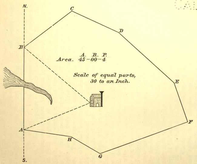
(Plat of Francis Jett's land)
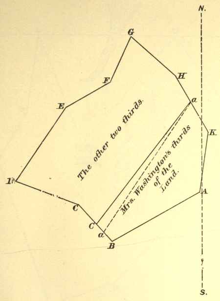
(Plat of Elizabeth Washington's land)
SURVEY'D For Richard Barnes Gentn of Richmond County[75] a certain Tract of Waste and ungranted Land Situate Lying and being in the county of Culpeper[76] and Bounded as followeth Beginning at three white Oaks in Normans Line and Corner Trees to (Aaron Pinson's now) Mr Barnes's Land & Extending thence No 42° 30′ Wt Ninety five Poles to a branch of Flat Run Two hundd and Eighteen Poles to a Large white Oak Corner to Norman thence along another of his Lines No 39° Et Thirty four Poles to three white Oaks & a Hickory Cor: to the said Norman and John Roberts thence along Robert's Line So 78° Wt One hundd and Eighty three Poles to the Road that Leads over Norman's Foard Two hundd and Sixteen Poles to two white Oaks in a Glade Corr to the said Roberts and Mr Francis Slaughter thence with the said Slaughters Line So 5° Wt One hundd and Sixty four Poles to three white Oaks in the said Slaughter Line thence leaving his Line So 66° Et Two hundd and thirty Six Poles to three white Oaks amongst a Parcel of Rock Stones Barnes's Corner thence with his Line No 53° Et One hundd and Eighty Six Poles to the Beginning Containing Four Hundred Acres this Twenty Second Day of July 1749.
John Lonem}Cha Men
Edward Corder}
Edward Hogan Marker
by
Washington S C C[77]
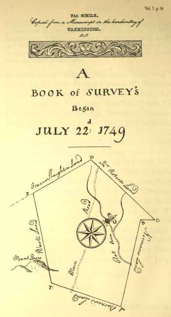
FAC SIMILE.
Copied from a Manuscript in the handwriting of
WASHINGTON.
Æt. 17
A
BOOK of SURVEY's
Began
JULY 22d: 1749
SURVEY'D For Edward Hogan a certain Tract of Waste and Ungranted Land Situate Lying and being in the County of Augusta[78] and on the Lost River or Cacapehon about Six Miles within the Boundary Line of the Northern Neck and bounded as followeth Beginning at a white Oak and white Pine Saplins on the West Side of the River and Runs thence So 68° Et Two hundred and Eighty Poles to three Chesnut Oaks on a Steep Mountain Side thence No 9° Et Two hundred and three Poles to three Pines on the Mountain Side thence No 68° Wt Two hundd and Eighty Poles to two white Oaks in a Drain that makes from the Mountains thence So 2° Wt One hundred and thirty two Poles to two white Oaks thence So 22° Wt Sixty Eight po. to the Beginning Containing Three hundred and Thirty five Acres this 1st Day of November 1749[79]
John Lonem}Cha Men
Edward Corder}
Edward Hogan Marker
by
Washington S C C
November 2d 1749 Then Surveyd for Robert Denton a certain Tract of ungranted Land Situate in Augusta County and on the Lost River of Cacapehon and Bounded as followeth Beginning at two white Pines and a Pitch and running thence So 62 Et Three Hundred Poles to a Chesnut, Pine and Spanish Oak on a Mountain Side thence No 28° Et Two hundred & Six poles to two white Oakes and a Hick. thence leaving the Mountain No 62 Wt Three hund poles to two Pines and a white Oak on a steep Hill thence to the Beginning
E Plat drawn Robert Denton, Marker
November 2d 1749[80] Then Survey'd for James Hamilton a certain Tract of Waste Land lying on Cacapehon and bounded as followeth Beginning at three Pines on a Mountain Side Corner to Edward Hogan and running thence along his Line No 68 Wt Two Hundred and Eighty Poles to three white Oaks another of his Corner's thence along the Mountain Side No 27 Et Two hundred Poles to a Poplar a Lynn & white Walnut Trees standing on the Creek thence crossing the Creek S. 68 Et Two hundred and Eighty Poles to a Large Black Oak and two Chesnut Trees growing from one Root thence to the Beginning along the side of an Inaccessable Mountain
E. Plat drawn Hogan Marker
Survey'd for Francis McBride Three hundred and Eighty Six Acres and a Quarter of Waste and Ungranted Land Situate Lying and being in the County of Augusta and on the Lost River or Cacapehon and Bounded as followeth Beginning at three Pines on very Hilly Ground and on the West Side the River and Runs thence So 62° Et Three hundred Poles to three white Oaks on the brake of the Mountains thence So 28° Wt Two hundred and Six Poles to two Black Oaks & a Dogwood thence No 62° Wt Three hundred Poles to two white Oaks and a Hickory Saplins on the Side of very Hilly Ground thence No 28° E Two hundred and Six Poles to the Beginning this third Day of November 1749
November 3 7th 1749 Then Survey'd for William McBride a certain Tract of Waste and ungranted Land Scituate in Augusta County and on the Lost River of Cacapehon and Bounded as followeth Beginning at three pines Francis McBrides Corner and runs thence with his Lines So 62° Et Three hundred poles to three white Oaks another of his Corners thence No 28° Et Two hundred and Six Pole to three white Oakes thence No 62 Wt Three hundred poles to two pines & a red Oak On a steep Hill from thence to the Begining
E Plat drawn John Donbarr M:
November 4th 1749 Then Survey'd for Ann Dunbarr a certain Tract of Waste Land Scituate in Augusta County and on the Lost River of Cacapehon and bounded as followeth Beginning at a Pine and white Oak pretty High up a Mountain Side and running thence So 65° Et Three hundred Poles to a white Oak Chesnut Oak and Maple on the Mountain Side near a Drain thence No 25° Et with the Mountain Two hundred and twenty Poles to three white Oak Saplins by a Runside thence No 65° Wt Two hundred and twenty Poles to a red Oak and Pine on the Creek Side thence up the Mountain Side far enough to make out three hund'd Poles from thence to the Beginning
E Plat drawn John Donbarr M.
November 5th 1749 Then Surveyd for Mr John Ellswick a certain Tract of Waste and ungranted Land Situate in Augusta County on the Waters of Cacapehon and bounded as followeth Beginning at three white Oakes Corner to Mrs Ann Dunbarr and running thence along the Mountain side No 25 Et One hundred Poles to three white Oaks in very Stony ground thence bearing more to the Mountain No 50 Et One hundred and twenty Poles to two Chesnuts and one Chesnut Oak near the side of some Large hanging Rocks on the side of a Mountain thence No 65 Wt Three hundred Poles to three white Saplins in the Hollow of a the Mountains near the Road that leads to the So Branch thence S 38 Wt One hundred and twenty poles to Dunbarr's Corner on the Mountain thence with his Line So 65 E Three hundred pole to the B.
E Plat drawn Josh How M.
Survey'd For James Scott Three hundred and Eighty Six Acres and a Quarter of Waste and Ungranted Land Situate Lying and being in the County of Augusta and on the Lost River or Cacapehon and Bounded as followeth Beginning at a Pine a Spruce Pine and Spanish Oak by the side of some Large Rocks on the East Side the River and Runs thence No 55° W Three hundred Poles to three Chesnut Oaks on Short Hills thence over the Hills No 35° Et Two hundred and Six Poles to a Large white Oak on the Hills or Ridges from the Mountains thence So 55° Et Three hundred Poles to a Hickory red Oak and Maple on the Mountain Side thence So 35° Wt Two hundred and Six Poles to the Beginning this Sixth Day of November 1749
November 7 1749 Then Survey'd for Mr Josh How a certain Tract of Waste and ungranted Land Lying in Augusta County and on the Lost River of Cacapehon and bounded as followeth Beg. at a Corner of the Land Survey'd for James Scott a Hickory red Oak and Maple on the Mountain Side and running thence along the Mountain No 35 Et Two hundred and Six Poles to two white Oaks and Maple on the Mountain thence leaving the Mountain and run thence No 55 W 60 po to the Road Three Hundred Poles to Red Oak Chesnut Oak and Hickory on a Mountain Side thence So 35° Wt Two hundred and Six poles to a Large white Oak James Scotts Corner thence with his line S 55 Et Three hundred poles to the Beg:
E. Plat drawn Josh How: M.
November 8th 1749 Then Survey'd for Andrew Viney a certain Tract of Waste and Ungranted Land Situate in Augusta County and on the Lost River of Cacapehon and Bounded as followeth Beginning at a Large white Pine and three Lynn Trees growing from one Stump & runs thence No 55° Wt Three hundred Poles to three white Oaks in amongst the Mountains thence went to the Beginning and runs So 35 Wt Two hundred & six poles to a Maple a Lynn and Wild Cherry Trees on the Mountain Side just on the Creek thence No 55 Wt Three hundred Poles to a white Oak and a Black & Hic. Oak from thence to his Opposite Corner No 35° Et
E Plat drawn Andrew Viney M
November 9 10th 1749 Then Surveyd for Mr Luke Collins a certain Tract of Waste and ungranted Land Situate in the County's of Augusta and Frederick & on the Lost River of Cacapehon and Bounded as followeth Beginning at two Chesnut Oaks and a Black and run thence S 55° Et 48 po to Barnaby McHandry's Corner thence with his Line to his Corner Lynn Maple & Mountain Burch on the Mountain thence along the Mountain S 35° Wt Two hundred and Six po. to two Mountain Burches and a Gum thence No 55 Wt three hundd poles to three white Oaks from thence to the Beg:
Plat drawn Saml McHandry M
November 9th 10th 1749 Then Survey'd for Barnaby McHandry a certain Tract of Waste and ungranted Land Situate in Frederick County on the Lost River of Cacapehon and Bounded as followeth Beginning 48 po. below William Bakers Corner 2 Chesnut Oaks and a White Oak and runs thence So 55° Et Two hundred and fifty two poles to two Mountain Burches and a white Oak on the M side thence So 35° Wt Two hundred and fifty two po to a Lynn a Maple and a Mountain Burch thence No 55° Wt Two hundred and Fifty two po to two white Oaks and a Hickory from thence to the Beginning
Plat drawn William Baker M
November 10 9th 1749 Then Surveyd for William Baker a certain Tract of Waste and ungranted Land Situate in Frederick County & on the Lost River of Cacapehon and Bounded as followeth Beginning at two Chesnut Oaks and a red Oak in amongst very steep pine Hills Saml Bakers Corner and runs then with his Line So 55° Et Three hundd Poles to two Mountain Burches and a Chesnt Oak on the M: th: alg the Mountain So 55° Wt Two hundd & Six poles to two Mountain Burches and a white Oak thence No 55 W Three hundred poles to two Chesnut Oaks & a white Oak from th. to the Beg
Plat drawn Saml Baker
November 10th 1749 Then Survey'd for Samuel Baker a certain Tract of Waste and ungranted Land Situate in Frederick County and on the Lost River of Cacapehon and Bounded as followeth Beginning at two white Oaks near very Large Rocks and runs thence No 55 Wt Three Hundred Poles to two white Oaks and a Black on the Short Hills thence went Back to the Beginning and So 25 W Two hundred and fifteen Poles to a Chesnut Oak and two Mountain Burches thence No 55 Wt Three hundred poles to two Chesnut Oaks and a red Oak
Plat drawn Saml Baker M
November 11th 1749 Then Surveyd for William Warden a certain Tract of waste and ungranted Land Situate in Frederick County and on the Lost River of Cacapehon and Bounded as followeth Beginning at two Hickorys and an Elm on the Creek side and runs thence So 70° Wt Two hundd & twelve Poles to a Spanish Oak a Chesnut & a Maple thence No 20° W: Three hundred poles to a Chesnut Oak a white Oak and Pine thence No 80 Et Two hundd and twelve pos and from thence to the Beginning
Plat drawn Saml Baker M:
March 30th 1750. Then Survey'd for David Edwards a certain Tract of waste Land Situate in Frederick County and on Cacapehon and bounded as followeth Beg: at a white Oak Josh Edwards Cor: on the Et side the River & run thence No 70 Wt 176 po to the Creek 253 Po to another of J. Edwards's Cors and three hundd & twenty Poles to three black Oaks near a Large Pine on the Top of a Hill thence No 20 Et Two hundd Poles to four Pines on the side of a steep Hill thence So 70° Et Three hundred & Forty Poles to an Ash on the Creek side near a fine spring thence to the Begg 412 Acres Plat drawn
John Lonem}Chn
Silvenus Smith}
David Edwards Mr
March 30th 1750 Then Survey'd for Thoms Edwards a certain Tract of Waste Land Situate in Frederick County and on Cacapehon & bounded as followeth Begg at 2 Pines on the side of a Mountain about 4 Pole from the Waggon Road that leads to the So Branch and on the Wt Side the Creek & run thence East One hundd Pole to the Creek & three hund and twenty Poles to a Red Oak white Oak and Hickory on the side of a steep Hill thence South Two hundred Poles to three white Oaks thence West 20 Po: to the Creek Three hundred & twenty Poles to a white Oak thence North Two hundred Poles to the Beg. containing four hundd acres
John Lonem}Cha:
David Edwards}
George Hyatt Plat drawn
March 31st 1750 Then Survey'd for George Hyatt a certain Tract of waste Land Situate on a branch of the No River calld Davids Run in Frederick County Beg at 2 white Oaks on the side of a Hill in very stony ground and Run thence So 70° Et One hundd & Seventy two Poles to a Chesnut Oak amongst a Parcel of Rocks on a Ridge of a Mountain thence No 20° Et..220 Po to the Wagn Road that leads to the So Branch Two hundd and Fifty Poles to a Hickory & two white Oaks thence No 70° Wt One hundd & Seventy two Poles to two white Oaks on a Hill thence So 20 Wt Two hundd & Fifty three Po: tods Begg Contg 272 Acres Plat drawn
John Lonem}C M
David Edwards}
George Hyatt : Markr.
March 31st 1750 Then Survey'd for John Parkes Junr a certain Tract of Waste Land Lying & Situate in Frederick County & on a branch of Cacapehon & bounded as followeth beginning at two Chesnut Oaks near a Drain of the Mountains that parts a Ridge of Rocks & run thence So Et..Two hundd Poles to three white Oaks at the foot of a mountain thence No Et..Two hund Poles to three white Oaks at the foot of the sd Mountain thence No Wt Two hundd Poles to three Pines on the same Ridge we began at thence So Wt Along the Ridge Two hundd Poles to the Beg: containing 250 Acres Plat drawn
John Lonem}C M
David Edwards}
John Parkes Markr
April 2d 1750 Then Survey'd for Even Pugh a certain Tract of Waste and ungranted Land Situate in Frederick County on the Trout Run a branch of Cacapehon & bounded as followeth begg at a white Oak & two Poplars standg on the Run & Run thence So 85° Et Three hund and twenty Poles to two red Oaks two Gums & a Maple thence No 40° Wt Three hundd & twenty Poles to a white Oak from thence to the Beg: So 27 Wt 244 Po. Cong 226...... Plat drawn
David Edwards}C: M
Joseph Powell}
Evan Pugh Junr Mark
April 2d 1750 Then Survey'd for Jacob Pugh a certain Tract of Waste Land Situate in Frederick County and on a branch of Cacapehon calld Trout Run begg at a Poplar and black Walnut on Evan Pugh's Line on the branch and Run thence No 50 Et One hundd & Sixty Poles to two white Oaks in a Bottom thence So 40 Et Two hundd and twenty Poles to three white Oaks thence So 50 Wt One hundd & Sixty Poles to two red Oaks two Gums & a Maple Evan Pughs Corner thence with his Line No 40 Wt Two hundd and twenty Poles to the begg containing 220 Acres Plat drawn
David Edwards}C. M
Joseph Powell}
Evan Pugh Junr Mr
April 2d 1750 Then Survey'd for Joseph Powell a certain Tract of Waste & ungranted Land Situate in Frederick C: & on a branch of Cacapehon calld Trouts Run begg at two white Oaks in a bottom Jacob Pughs Corner and run thence with his Line So 40° Et Two hundd & twenty Poles to three white Oaks another of J— Pughs Corner's thence No 50 Et One hundd & Sixty Poles to three white Oaks thence No 40 Wt Two hundd & twenty Poles to two Pines thence So 40 Wt One hundd & Sixty Poles to the Beg: Containing 220 Acres Plat drawn
Jacob Pugh}C. M
Evan Pugh}
Joseph Powell M
April 2d 1750 Then Survey'd for Thoms Hughs a certain Tract of Waste & ungrand Land Situate in Frederick County & on Cacapehon & boundd as followeth beg: at a red Oak & white Oak at the foot of a steep Mountain and run thence No 25 Wt One hundd and Seventy 4 Poles to an Elm & red Oak Saplins thence No 45° Wt...Three hundd & Forty Poles to two Pines on a Ridge thence No 75° Et Two hundd Poles to two red Oaks in the bottom thence So 25° Et Three hundd & forty Poles to three white Oaks near the lick Branch thence to the beg. Cong 419 Acres Plat drawn
Jacob Pugh}C: M
Evan Pugh}
William Hugh's Mr
April 3d 1750 Then Survey'd for Hugh Hughs a certain Tract of waste & ungranted Land Situate lying & being in Frederick County & on Cacapehon & bounded as followeth beginning at two swamp white Oaks standing under a steep hill & run thence No 75 W Four hundd & twenty Poles to two Pines and a Chesnut Oak on the Ridge of a Mountain thence So 17 Wt Two hundd Poles to two white Oaks thence So 73° Et at 72 po came to a black in thoms Hughs's Line about 80 po: from his corner at 192 Po came to three white Oaks in another Line of Ths Hughs's four hundd and twenty Poles to three white Oaks from thence to the begg Cong 480 Acres Plat drawn
John Lonem}C M
Josh Powell}
William Hughs Mr
April 3d 1750 Then Survey'd for William Hughs Senior a certain Tract of Waste Land Situate in Frederick County and on Cacapehon & bounded as followeth beg. at two swamp white Oaks hugh hughs Corner & run thence No 17 Et Two hundd Poles to three white Oaks near the Creek thence No 73° Wt Three hundd and twenty Poles to three Pines on the side of a Mountain thence So 17° Wt..Two hundd Poles to the beg: containing 400 Acres Plat drawn
John Lonem}C. M
Joseph Powell}
Elias Hughs Mr
April 4th 1750 Plat drawn Then Survey'd for William Hughs Junr a certain Tract of Waste & ungranted Land Situate lying and being in Frederick County & on Cacapehon & bounded as followeth beg at three white Oaks & run thence No 73° Wt 40 Pole to William Hughs Senr Corner Three hundd & twenty Poles to a stake thence No 35° Et Two hundd & twenty Poles to three Gums in a Drain of the Mountain thence So 73° Et Three hundd & Eighty Poles to two white Walnuts thence to the beg So 47 Wt 245 Po Cong 460 Acres
John Lonem}C. M
Evan Pugh}
Elias Hughs—Mr
April 4th 1750 Plat drawn— Then Survey'd for Nicholas Robinson a certain Tract of waste Land Situate in Frederick County & on Cacapehon & bounded as followeth beginning at two white red Oaks about two pole below a spring & under a mountain & clift of Rocks & run thence So 45° Et Two hundd & sixty Six Pole thence So 45° Wt Two hundd & Forty Pole thence No 45° Wt Two hundd & Sixty Six Pole to 2 Pines & 1 White Oak thence No 45° Et Two hundd & Forty Poles to the beg: Containing 400 Acres
John Lonem—}C. M
Samuel Brown}
Nicholas Robinson Mr
April 5th 1750 Plat drawn Then Survey'd for William Henry Welton a certain Tract of 390 Acres of waste and ungranted Land Situate in Frederick County & on Cacaphon & bounded as followeth beg. at two white Oaks & a black Oak John Woodfins beg: Corner & run thence So 50° Wt Two hundd Poles to two Pines high on a mountain Side thence So 35° Et Two hundd & Sixty Poles to three white Oaks in William Hughs Junr Line thence with his Line So 73 Et 100 Pole to two white Walnuts under a clift of Rocks on the Creek William Hughs corner thence I Went back to the beg. & run with Woodfins Line So 20 Et Eighty Six Po: crossing Cacapehon to a red oak & white Walnut thence So Et One hundd & sixty one Pole to a white Oak near ye foot of a hill then close the Line
The above Plat begins at Woodfins Corr & run N Wt
John Lonem}C. M.
Samuel Woodfin}
John Welton
April 5th 1750 Plat drawn Then Survey'd for Edward Kinnison Junr a certain Tract of Waste Land Situate in Frederick County & on Cacapehon & bounded as followeth beg. at two red Oaks N. Robn Corner about 2 Pole below a Spring & run thence So 45° Et Three hundd & Twenty Poles thence No 45 Et two hundd Poles thence No 45° Wt Three hundd & Forty Po. to two white Oaks under a mountain & clift of Rocks thence to the beg.
John Lonem}C. M
Saml Brown}
Edward Kinnison Mr
April 5th 1750 Plat drawn Then Surveyd for John Lonem a certain Tract of waste Land Situate Lying & being in Frederick County & on Cacapehon & bounded as followeth beg: at two white Oaks under a clift of Rocks Edward Kinnison's Corner & run thence No 37° Et Two hundd & forty Poles to two hickorys & white Oak on a Mountain Side thence So 53 Et Two hundd & forty Poles thence So 38° Wt 274 Po. to Intersect Kinnison N Wt Line thence N Wt 240 to the begng Cong———390 Acres
John Lonem}Chn Men
Saml Brown}
Nicholas Robinson M
April 10th 1750 Plat drawn. Then Surveyd for Darby McKeaver Senr[81] a certain Tract of waste & ungranted Land situate Lying & being in Frederick County and on Cacapehon & bounded as followeth beg: at One white Oak & two hickorys John Lonems Corner & run thence No 37 Et Two hundd and twenty Poles to 2 Pines & a black Oak on a steep Mountain side thence So 53 Et Three hundd Poles to two white Oaks & a Pine thence So 37 Wt Two hundd & twenty Poles from thence So 53 Wt 60 Po to John Lonem's Corner Three hundd Poles to the beg. Cong 412½ Acres
John Lonem}C. M
David Edwards}
James Dilouza Mr
April 10th 1750——this Card to Foo 82 Then surveyd for Darby McKeaver Junr a certain Tract of waste Land Situate in Frederick County & on Cacapehon & bounded as followeth beg: at a red Oak & Pine about a Mile & quarter below his other Survey and Run thence So 53 Et One hundd Poles to 2 white Oaks thence So 20 Et Two hundd & thirty eight Poles to a spanish Oak white Oak & hickory thence S 37 W ninety two Poles to 2 Pines & a white Oak thence No 53 Wt Three hundd Poles to three Pines from thence to the beg.
John Lonem}C. M
David Edwards}
James Dilouza Mr[82]
April 10th 1750 Then Surveyd the vacant Lot betwixt Darby McKeaver and Son in Frederick County & on Cacapehon & bounded as followeth beg: at 3 Pines Sons Corner near the Mountain & Run thence So 37 Wt Two hundd & ninety Six Pole to Darbys Line & twenty Pole from the Corner then went to the Corner & run with his Line So 53° Et & so Round ye whole binding on their Lines & Corners
John Lonem}C. M
David Edwards}
April 11th 1750 Plat drawn Then Surveyd for John Parke Senr a certain Tract of waste Land situate in Frederick County & on Cacapehon & bounded as followeth beg: at two Pines on a Mountain Side & run thence S 57 Et Three hundd & twenty Poles to a Pine & two hickory bushes on the Top of a clear hill thence So 33° Wt Two hundd Poles to 2 white Oaks in Level ground thence No 57 Wt 200 Pole to the Creek Three hundd & twenty Poles from thence to the beg
John Lonem}
Silvenus Smith}
Richd Arnold—Senr
April 11th 1750 Plat drawn Then Survey'd for Richard Arnold Junr a certain Tract of waste Land Situate in Frederick County & on Cacapehon & bounded as followeth beg: at a black Oak & hickory at the foot of a Mountain & run thence So 57 Et Three hundd & twenty Poles to 2 Pines & a Spanish thence So 33 Wt Two hundd Pole to a hickory black Oak & white Oak thence No 57 Wt Three hundd & twenty Poles to two white Oaks from thence to the beg:
John Lonem}
Silvenus Smith}
Richard Arnold Junr
April 11th 1750 Then Survey'd for Mr Joseph Edwards a certain Tract of waste Land Situate in Frederick County & on Cacapehon & bounded as followeth beg: at a black Oak & hickory at the foot of a Mountain Richard Arnold's Corner & run thence with his Line So 57 Et Three hundd & twenty Poles to a Pine & 2 Spanish Oaks another of Arnolds Corner's thence No 33 Et Two hundd Poles to three white Oaks by a small branch near a Path thence No 57 Wt Three hundd & twenty Poles to two white Oaks on the Mountain side thence to the beg
John Lonem}
Silvenus Smith}
Richard Arnold Senr
April 12th 1750 Plat drawn Then Surveyd for James Caudy[83] a certain Tract of waste Land Situate in Frederick County & on Cacapehon & bounded as followeth beg at a white Oak on the East Side the Creek a Corner of his Patent Land & run thence So 53 Et 200 Po: to a white Oak on a Level near the Waggon Road another of his Corners thence So 37 Wt Ninety Six Poles to a white Oak in Josh Edwards Line thence with his Line No 57 Wt 110 Po. Josh Edwards Corner thence to ye beg containing 98 Acres
John Lonem}
Sylvenus Smith}
Richd Arnold Junr
April 12th 1750 Plat drawn Then Survey'd for Thomas Parker Senr a certain Tract of waste Land Situate in Frederick County & on the No River of Cacapehon & bounded as followeth beg at 2 white Oaks on ye W. side the Creek & Run thence No 36 Wt Two hundd Pole to a Hickory & black Oak in the bent of the Creek th: So 54 Wt Two hundd Pole to two Pines on a Stony & Piney Point thence So 62 Wt Eighty four Poles to a white Oak & maple on ye Creek thence So 30 Wt One hundd & Eighty Poles to 3 Pines & a white Oak in flat Level Ground from thence to the beg. No 38 Et 220 Cong 237 Acres
John Lonem}
Richd Arnold Senr}
Barnaby Lynch—
April 13th 1750 Plat drawn Then Survey'd for Evan Pugh Junr a certain Tract of Waste Land Situate in Frederick County on a very small branch & bounded as followeth beg at 3 white Oaks on a Stony Ridge & run th: So 60 Et One hundd & Sixty Po: to two Chesnut Oaks & a Pine th: No 30 Et One hundd & Sixty Pole to two red Oaks & a white Oak thence No 60 Wt One hundd & Sixty Pole to a Chest Oak & black Oak on a Rocky Ridge thence So 30 Wt One hundd & Sixty Pole to the beg: Cong 160
John Lonem
James Thomas
Jacob Pugh:
April 13th 1750 Plat drawn Then Survey'd for Benjamin Phipps a certain Tract of Waste & ungranted Land Situate in Frederick County & on the North River of Cacapehon & bounded as followeth beg: at a white red & Chesnut Oaks on ye west side the River & run thence No 26 Wt Three hundd & twenty Poles to three Pine Saplins in very hilly Ground thence So 64 Wt Two hundd Pole to three white Oaks on the Top of a Mountain thence So 26 Et Three hundd & twenty Poles to 3 white Oaks in a hollow th: to the beg
John Lonem}C: M
Aaron Ashbrook}
Benjamin Phipps Mark.
April 14th 1750 Plat drawn Then Surveyd for George Nickson a certain Tract of waste Land Situate in Frederick County & on the No River of Cacapehon & bounded as followeth beg. at 3 red Oaks on the River Side & Wt side & run thence No 60 Wt Three hundd & twenty Poles to 2 Black Oaks & a Pine thence S 30 Wt Two hundred Poles to a white Oak & Pine in the fork of three hollows thence So 60 Et Three hundd & twenty Pole to two Pines 20 Po x[84] ye Creek thence No 30 Et Two hundd Poles to the beg: containing 400 Acres
John Lonem}C. M
James Smith}
George Nickson Mr
April 14th 1750 Plat drawn Then Survey'd for Josiah Arnold a certain Tract of waste Land Situate in Frederick County & on the No River of Cacapehon & bounded as followeth beg: at a red Oak near a great Rock on the East side ye River & run thence No 48 Wt Three hundd & twenty Poles to two Pines thence No 42 Et Two hundd Pole thence So 48 Et Three hundd Poles to the Creek Three hundd & twenty Poles to 2 Lynn Trees & a Maple thence So 42 Wt to the beg: containing 400 Acres
John Lonem}
James Smith}
Josiah Arnold
April 14th 1750 Plat drawn Then Surveyd for James Smith a certain Tract of waste Land Situate in Frederick County & on the No River of Cacapehon & bounded as followeth beg: at a hickory & Walnut on ye Creek Side & west Side & opposite against a Pavement of Rocks & run thence No 48° Wt Three hundd & twenty Poles to 2 Pines amongst steep Hills thence No 42 Et 200 Pole to 2 Pines thence So 48° Et Three hundd & twenty Poles to 2 Pines on a Mountain Side thence So 42 Wt 200 Pole to the Beg: Containing 400 Acres
John Lonem}
George Nickson}
James Smith
April 16th 1750 Plat drawn Then Surveyd for John Stackhouse a certain Tract of Waste & ungranted Land Situate in Frederick County & on the No River of Cacapehon & bounded as followeth beg at a Large white Oak & hickory on the Et side the River & run thence No 45 Wt Three hundd & five Pole thence So Wt Two hundd & Ten Pole thence So Et Three hundd & five Pole to two white Oaks in a small Island under the foot of a Mountain thence No Et Two hundd & ten Pole to the beg. Containing 400 Acres
John Lonem}—
James Smith}
John Stackhouse
April 16th 1750 Plat drawn Then Surveyd for James Warden the Vacant Land situate in Augusta County & between ye Lines of Andrew Viney & Luke Collins on the Lost River & bounded as followeth beg: at 3 white Oaks amongst Piney Hills Luke Collins's Corner & run thence with his Line So 55° Et Three hundd Poles to two Mountain Burches & a Gum on a steep Moun. side thence So 35 Wt One hundd & Seventy Six Pole to a Large white Pine & three Lynn Trees growing from one Stump Andw Vineys Corner thence with his Line No 55 Wt Three hundd Poles to three white Oaks in amongst ye Mountains another of V. Corners thence to ye beg Cong 330 Acres
John Lonem James Scott
April 16th 1750 Plat drawn Then Survey'd the Waste Land for Francis McBride & Robert Denton between their Lines beg: at 2 Pines & a Spanish Oak on the left side the River & run thence No 28° Et 128 Pole to Frank McBrides Line thence up his Line to his Corner No 62° Wt 72 Pole to McBrides Corner 2 white Oaks & a hickory when plotted of is from Dentons Corner to McBrides, North 148 thence around with there Lines containing 244 Acres
John Lonem Daniel Lizenby Robt Denton
April 18th 1750 Plat drawn Then Survey'd for David Dunbar a certain Tract of waste Land Situate in Augusta County & on Cacapehon & bounded as followeth beg at a white Oak Chesnut Oak & Maple Corner to Ann Dunbar & run thence So 25° Wt Two hundd Poles to 3 white Oaks thence No 65 Wt Three hundd & Eighty Poles to 3 white Oaks at the foot of a Mountain thence to John Dunbar corner from thence with his Line to ye beg Contg 425 Acres this Plat beg: at John Dunbar's beg. Corner
John Lonem Daniel Lizenby William Warden
April 19th 1750 Plat drawn Then Surveyd for William Miller Horse Jockey a certain Tract of waste Land Situate in Augusta County & on the Lost River of Cacapehon & bounded as followeth beg at a white Oak & Spruce Pine Edward Hogan's Corner & Run thence So 10° Wt Two hundd & twenty Poles to 3 white Oaks on the Edge of the bottom thence So 68 Et Two hundd & Eighty Poles to 2 Chesnut Oaks & a hickory on a Mountain Side thence No 10 Et Two hundd & twenty Poles to another of Hogan's Corners thence with his Line to the beg Cong 380 Acres
John Lonem Danl Lizenby William Miller
April 19th 1750 Plat drawn Then Surveyd for James Thomas a certain Tract of waste Land Situate in Augusta County and on the Lost River or Cacapehon & bounded as followeth beg at two white Oaks by a small branch & run thence So 65° Et Three hundd Pole to 2 white Oaks good way on the Mountain side thence No 25 Et Two hundd Pole to an hickory Maple & Ash on a Rocky Run thence No 65 Wt Three hundd Poles to 3 Pines then So 25 Wt Two hundd Poles to the beg Cong 375 Acres
John Lonem William Miller Robert Denton
April 20th 1750 Plat drawn Then Surveyd for James Dilouza a certain Tract of waste Land Situate in Frederick County & on a branch of the No Branch of Cacapehon & bounded as followeth beg: at a Chesnut Oak white Oak & hickory on a hill near the Mountain Side & run thence No 52 Wt Two hundd & fifty two Poles to a white Oak & black Oak thence So 38 Wt Two hundd & fifty two Poles to 3 Spanish Oaks on ye Mountain Side thence So 52 Et Two hundd & fifty two Poles to 3 Spanish Oaks on a Mountain Side thence to ye beg: Contg 397 Acres
John Lonem James Warden James Dilouza
April 20th 1750 Drawn Then Surveyd for David Wood a certain Tract of waste & ungranted Land Situate in Augusta County & on ye No River of Cacapehon & bounded as followeth beg: at a hickory & Walnut against a Pavement of Rocks James Smiths Corner & Run thence So 42 Wt two hundd Pole to a white Oak & hickory on ye west side ye Creek thence No 48 Wt have recourse to ye returnd Survey[85]
John Lonem John Stackhouse Daniel Wood
April 20th 1750 Plat drawn Then Surveyd for Jonathan Arnold a certain Tract of Waste Land Situate in Frederick County & on ye No River of Cacapehon & bounded as followeth beg: at a white Oak & hickory on ye Et side ye River David Woods Corner & Run thence with his Line No 48 Wt Three hundd & twenty Poles to his corner thence So 42 Wt Two hundd Pole thence So 48 Et Three hundd & twenty Poles to 2 Pines thence No 42 Et 200 po[86] to ye beg: Containg 400 Acres
320No 48 Wt 320} [86]
200So 42 Wt 200}
——–So 48 Et 320}
6400 ɭ 400No 42 Et 200}
640
John Lonem John Stackhouse Jonathan Arnold
April 21st 1750 Plat drawn Then Surveyd for Robert Lindsay a certain Tract of Waste Land Situate in Frederick County & on ye No River of Cacapehon & bounded as followeth beg: at 3 white Oaks & on ye foot of a Mountain & run thence No 48 Wt Three hundd & twenty Poles to thence No 42 Et Two hundd Poles thence So 48 Et Three hundd & twenty Poles to a forked Pine & white Oak thence So 42 Wt Two hundd Poles to ye beg: containing 400 Acres
John Lonem John Stackhouse Jonathan Arnold
April 23d 1750 Plat drawn Then Surveyd for Henry Enoch a certain Tract of waste Land Situate at ye Fork of Cacapehon & bounded as followeth beg. at 2 red Oaks near ye Cacapehon & Run thence No 12 Et Two hundd Poles to red Oak & Spanish Oak on ye side of a steep Hill thence No 78 Wt 100 Pole to ye Creek Two hundd & Seventy Poles to 2 white Oaks & a red Oak thence So 12° Wt 200 Po to ye No River Two hundd & Sixty Poles to 2 white Oaks & a hickory thence to ye beg: So 78 Wt 275 Poles Cong 388 Acres
John Lonem}
John Keith}
John Constant
April 23d 1750 Plat drawn Then Surveyd for John Newton a certain Tract of waste Land Situate in Frederick County & on ye No River about a Mile above ye Fork and bounded as followeth beg: at 2 white Oaks & a hickory Henry Enocks's Corner & run thence with his Line No 12 Et Two hundd & Sixty Poles to another of Enocks Corners 2 white Oaks & red Oak thence West Two hundd Poles to 2 hickorys & a Pine thence So 12 Wt Two hundd & Sixty Poles to 2 Pines in clear Ground thence East 200 to ye beg: at 50 Po came to ye No River Cong 315 Acres
John Lonem}C. M
John Keith}
John Constant Marker
April 24th 1750 Plat drawn Then Surveyd for Thomas Wiggans a certain Tract of waste Land Situate in Frederick County & on Potomack River about ½ Mile above ye Mouth of great Cacapehon & bounded as followeth beg: at a white Oak a white Hickory & white Wood Tree just on ye Mouth of Wiggan's Run & opposite to a nob of ye Mountains in Maryland & run thence So 25 Wt Two hundd & twenty Eight Poles to a white hickory an Elm & Mulberry about 30 Pole from Cacapehon thence No 75 Wt One hundd & forty Poles to a Chesnut Oak & white Oak thence No 25 Et Two hundd & Sixty Poles to a white Oak red Oak & Iron Wood on ye Riverside thence down ye several Meanders thereof So 67½ Et 37 Po So 58½ Et 74 Po So 55 Et to ye beg Cong 210 Acres—
John Lonem Isaac Dawson William Wiggans
April 24th 1750 Plat drawn Than Survey'd for Isaac Dawson a certain Tract of waste Land Situate Lying & being in a Neck of Land between Cacapehon & Potomack River & bounded as followeth beg at a white Oak white hickory & white Wood tree Thoms Wiggans Cor. & run thence with his Line So 25 Wt One hundd & Eighty two Poles to a Walnut & hickory in Ts Wiggans Line thence So 75 Et twenty Pole to 2 white Oaks on ye Creekside thence ye several Meanders thereof No 69 Et Thirty six po So 60½ Et 62 Po; So 40½ Et 56, So 26 Et One hundd & twelve Po, So 59 Et fifty four Po., No 38 Et Seventy two Pole, No 28 Et Thirty eight, Po No 2 Wt 44 Po; No 56½ Wt 50 No 40 Wt 44 Po, No 51 Wt 26 Po No 42 Wt 52 Po. So 10½ Et 42 to ye Mouth of ye Creek thence up ye Meanders of ye River No 71 Wt 92 Po No 45 Wt 30 Po. to ye beg. Cong 270 Acres—
John Lonem William Wiggans Isaac Dawson—
April 24th 1750 Plat drawn Then Surveyd for Thoms Williams a certain Tract of waste Ld Situate just below ye Mouth of ye Caca & on Potomack River & bounded as followeth beg: at a Maple & Sugar at ye Mouth of ye Creek & Run ye Meanders of ye River So 79 Et 90 Po So 70 Et 50 Pole to a White Oak & Sugar tree growing together at ye Top by ye Mouth of a gully thence leaving ye River & Run thence So 1 Wt One hundd & fifteen Po th== So 72 Wt 28 Po to ye Ck & ope to Dawson's C: ye two last Courses down ye Creek are No 42° Wt 35 P No 17° Et 52 P to ye beg Cong 95 Acs
John Lonem William Wiggans Thoms Williams
April 25th 1750 Plat drawn Then Surveyd for Nicholas Friend a certain Tract of waste Land Situate on Potomack River about 2 Miles below ye Mouth of Little Cacapehon & bounded as followeth beg at 2 hickorys & a Sugar Tree at ye Mouth of a Run on ye River brink & run thence So 55 Et Sixty Pole to two Pines on ye top of a Ridge thence So 35 Wt One hundd & Sixty Poles to 2 white Oaks & an ash about 18 Pole x ye Run we began at thence No 55 Wt One hundd & thirty Pole to 2 Sycamores on ye River Side thence down ye Meanders of ye River No 4 Wt fifty four Po. No 28 Et forty Po. No 70 E twenty Six Po. No 75 Et Twenty one Po. No 79½ Et Thirty Poles So 80 Et 72 Po. to ye beg. Cong 142 Acres
John Lonem Samuel Plumb John Friend
April 25th 1750 Plat drawn Then Survey'd for Friend Cox a certain Tract of waste Ld Situate in Frederick Coty & on Potomack & Little Cacapehon & bounded as followeth beg. at 2 hickorys & a Spanish Oak at ye Mouth of Little Cacapehon & ye lower Side & run thence ye Meanders of ye River No 84 Et thirty Pole So 86 Et Twenty Eight Pole No 65 Et 68 Pole East forty Pole to 2 Burches thence leaving ye River So 10 Et Two hundd & forty Poles Run So 80 Wt One hundd & thirty Poles to ye Creek then No 22 Wt Sixty Pole No 45½ Wt 100 Po No 12 Et 30 No 39 Et 16 Po No 15 Wt 56 Po to ye beg Cong 240 Acres
John Lonem John Parker Richd Lane
April 26th 1750 Plat drawn Then Survey'd for John Parker of So Brch a certain Tract of waste Land Situate in Frederick & on Little Cacapehon & about ½ Mile above ye Buffilo Lick & bounded as followeth beg: at a white Oak & red Oak on ye hillside & Run thence So 50 E Two hundd Pole thence So 40 Wt One hundd & Sixty Pole thence No 50 Wt Two hundd Pole to a black Oak Spanish Oak & white Oak thence No 40 Et One hundd & Sixty Poles to ye Beg: Containing 200 Acres
John Lonem Henry Enoch John Parker
April 27th 1750 Plat drawn Then Surveyd for Silvenus Smith a certain Tract of waste Land Situate in Frederick County & on Cacapehon & bounded as followeth beg: at a hickory black Oak And white Oak Richd Arnolds Corner & run thence with his Line No 57 Wt Three hundd & twenty Poles to 2 white Oaks another of Arnolds Corners thence So 33 Wt One hundd & twenty four Poles to 2 Pines John John Parke Senr Corner thence with Parke's Line So 57 Et Three hundd & twenty Poles to a Pine & two hickorys another of Parke's Corner thence to ye beg: find ye Course & Quantity[87]
John Lonem...}
Richd Arnold Junr}
Silvenus Smith
April 27th 1750 Plat drawn. Then Resurveyd Darby McKeaver's Junr Land beg. at a red Oak & Pine his old Corner & Run thence So 53 Et 70 Po to a hickory & black Oak on ye Creek Side then up ye Creek So 37 Wt 60 to 2 black Oaks on ye Creek Side thence So 53 Et 230 Po. to 2 Chesnut Oaks & a black on Piney Ground thence So 37 Wt 140 Po to 2 Pines & a white Oak thence No 53 Wt Three hundd Poles to three Pines find ye Course[87] from thence ∧ to ye beg: Cong 315 Acres
John Lonem Silvenus Smith Roger Parkes
April 28th 1750 Plat drawn. Then Surveyd for James McCay a certain Tract of Waste Land Situate in Frederick County bounded as followeth beg: at 2 white Oaks & a Gum in Level Ld about 10 Po from ye Waggon rd & run thence So 27 Wt Three hundd & twenty Po to 3 white Oaks thence No 63 Wt 30 Po to ye Waggon Road that Leads up ye Creek to Woodfins two hundd Poles to 2 Chesnut Oaks thence No 27 Et 270 Po to ye Wagn Road Three hundd & twenty Poles to 3 Pines thence So 63 Et Two hundd Pole to ye beg Cong 400
John Lonem David Edwards James McCay
August 16th 1750 Plat drawn. N. B. This Plat made to begin at ye Double hickory So 11½ Wt 280 po. Then Survey'd for Mr Edward Musgrove a certain Tract of waste & ungranted Land Situate in Frederick County & on Shannondoah River & joining his Patent Land bounded as followeth Beg. at a Corner Stone where his Corner tree stood on the River Side & run up the several Courses thereof So...63°...Wt..40 poles So..43°..15″ Wt 60 poles to an Ash on the River Corner to William Vestalls Patent Land thence with his Lines No 40 Wt Eight poles to a white Oak Saplin V. C. thence So..70 Wt 92 poles to 1 blacks oak in ye fork of a road thence No..31¼ Et 426—Poles to a Double hicy Cornr to Musgroves Pa. Ld & ye pat. Ld of John Vestall thence to ye beg 135 Acres——
Reuben Rutherford}Ned Musgrove Mr
John Musgrove}
August 20th 1750 Plats drawn Then Re Survey'd for Richard Stephenson and William Davis a certain tract of waste and ungranted Land beg: at 1 Spanish Oak black Oak & white Oak & run thence No....10°...Et Forty three poles to a Large hic: in a hallow thence So...80 Et One hundd poles to a Large white Oak & small hickory in or near ye Old Corner th: So..37..Et One hundd & Eighty four poles to a Dead white O. & living one by a path side thence No..36....Et Thirty Six poles to a Stoopg white Oak by a path Side Corner to a tract Survey'd for William Davis thence So — —50°-45′...Et four hundd and twelve poles to a red Oak Another Corner of William Davis's Land in Colo Geo. Fairfax's Line thence So 41 Wt Three hundd & Ninety Eight Poles to a hickory Saplin about 8 pole x the No Branch of Bullskin[88] thence No..37°...Wt...Two hundd & Eighty poles to small hickory Saplins about 90 pole from the Corner of the Patent Land a broken topd red Oak Pits's—Patent thence with his Lines No 50 Et Seventy poles to a red Oak in Stephensons clear'd Ground—thence No 5 Wt 242 p to a Corner—Two hundd & fifty poles to 2 hickorys thence No—35°—Wt 160 po. thence No 85° 30′ Wt 18 ps- to a Large white Oak by a parcel of Rocks then reduced to a straight Line is No...40°-45′..Wt One hundd & Seventy One po thence No...80—Wt Seventy Eight poles to the beg: cong 810
Lewis Thomas}398
William Crawford}240
Daniel McKleduff Mr. 158
August 21 to 23 1750 Plat drawn Then Survey'd for Majr Lawrence Washington the Waste Land between the Lines of Mr Worthington Davis & T Keys bounded as followeth beg at 4 Sycamores standing on the edge of Worthington's Run being his C: & run thence So 72 Wt Twenty eight Poles to a red Oak thence No 78° Et Two hundd & Ninety four poles to several small Saplins Wory beg. Corner thence So 20° Wt Two hundd & Sixty poles to a red Oak, thence No 70 Wt One hundd & twenty poles to a white Oak, thence No 20 Wt Two hundd & Seventy Six poles to a white Oak, Then West Forty five Poles to a white Oak hickory & Walnut So 10° Wt Five hundd & forty poles to a black Oak thence So 80° Et Sixty poles to a white Oak thence No 10° Et 45 poles to a C: of Pitts's Patent Land Eighty Eight poles to a Large hickory in a hallow Corner to ye Ld Surveyd for Davis & Stephenson thence with their Lines So 80° Et One hundd poles to a Large white Oak & small hickory thence So 37¼° Et One hundd & Eighty four poles to 2 white Oaks one of them Dead by a path side thence No 36 Et Thirty Six poles to a stooping white Oak by the So path Corner to a Sepee Survey made for William Davis thence with his Lines No 29¼° Et One hundd & fifty Six poles to 2 red Oaks Davis's Corner thence to a Corner of his Patent Ld So 54 Et Six poles a Large red Oak ye beg. C. of his Patent (his patent Lines being protracted) went to ye Corner of Samuel Waker's Patent Ld now W a white Oak & run thence along his Line & keys So 17 W Three hundd & thirty four poles to 2 red Oaks where Keys Corner shd stand the Courses being protracted thence So 72° Et Two hundd & four poles to a hickory on the West side a Meadow where Davis's Patent sd Corner then following the Courses of his patent S Wt One hundd & Eight poles to a red Oak on ye side of a hill (ye patent says a hickory but their is neither Line or Corner to be found) thence No 70° Wt One hundd & forty poles to a black Oak & white Oak Near a glade & on ye No side th: No 45° Wt 148 po: to a Large Oak in a small hallow thence N Et 22 po to a hic: Sap th. N Wt 76 poles to 3 tri. hic near a path th. No 82 Et 82 poles to Davis's patent Cr
Wm Crawford}C C
Lewis Thos}
Daniel McKleduff.
August 23d 1750 Then survey'd for Maj'r Lawr Washington of Fairfax County a certain tract of waste and ungranted Land in Frederick joining Worthington's Land and Beg: at the 2d corner the sd Worthington's tract a red Oak and extended with his Line No 70 W one hundred and twenty poles to white Oak thence leaving his Lines and extended So 60 W one hundred and seventy four poles to two white Oaks, one double stand'g on y'e side of the Old wag'n Road thence No 80 W fifty Six poles to a white Oak and hic'ry in Worthingtons Line thence with his Lines So 10 W. two hundred poles to a black Oak thence So 80 E. Sixty poles to a white Oak thence No 10 E.t 25 po to a c'r of Pitts's patent L'd Eighty eight poles to a large hi'ry c'r to a survey known by that of Pitts's now Stephenson's Jr then with these Lines So 80 E.t one hund'd poles to a large white Oak and small hic'ry thence So 87¼ E.t one hundred & Eighty four poles to two white Oaks one of them dead & stand'g by a path thence No 86 E.t thirty six poles to a Sloaping white Oak on the edge of the s'd path c'r to a survey made for Wm Davis thence with his Lines No 29¼ Et one hund'd and fifty six poles to two read Oaks So 54 Et six po to a c'r of his pat'd L'd th: with a Line therof No 82 E.t 82 po to 3 live hic'ry thence No 10 W. one hund'd and Eighty four poles and So 85 W. One hund'd and fifteen poles to the Beg: con'g Six hund'd and thirteen acres.