BACKGROUND
Reading edition
Distribution and Abundance of Humpback Whales in the North Pacific[1]
Humpback whales are seasonal migrants found in all of the world's oceans. In the North Pacific, humpback whales winter in tropical regions over the shallow coastal shelfs associated with the Hawaiian Islands, Baja California, central Mexico, the Ryukyu Islands, Bonin Islands, and Mariana Islands. They summer in cold temperate regions, also over shallow coastal shelfs, from Point Conception, California, north through Alaska, west through the Aleutians, and south to Honshu Island, Japan. Calving and probably breeding occur on the wintering grounds. Feeding is believed to occur primarily in the summering grounds.
In Alaska, humpback whales are known to inhabit Prince William Sound, the waters of the Alexander Archipelago, and the waters adjacent to Kodiak Island and the Aleutians. Some whales may also overwinter in the northern summering areas.
The distribution, movements, abundance, and habitat requirements of humpback whales are not well known. Based upon Japanese catch statistics, the pre-exploitation population of humpback whales in the North Pacific is estimated to have been approximately 15,000. Much of the exploitation of humpback whales occurred in the twentieth century, especially during the early 1960's. A small number of whaling stations established in southeast Alaska took humpbacks between 1907 and 1922. In 1966, the International Whaling Commission imposed a worldwide ban on the taking of humpback whales.
The present population of humpback whales in the North Pacific is estimated to be about 1,000 animals. The number occurring in tropical waters during the winter is thought to be about 600-700 in Hawaii, 200-300 in Mexican waters, and a "few whales" in the western North Pacific. More than 100 individual whales have been identified in the inland waters of southeast Alaska during the summer. Tagging experiments with Discovery Marks indicate movement between the Aleutian Islands and the Western North Pacific; recent photo-identification studies have shown movement from Southeast Alaska to both the Hawaiian Islands and Baja (and southern coastal) Mexico. There is no substantive evidence to indicate whether the number of humpback whales, on either summer or winter grounds, in the North Pacific is increasing or decreasing.
FIGURE 1. Map showing location of Glacier Bay, Lynn Canal and Fredrick Hole in Southeast Alaska Alexander Archipelago (from Jurasz and Jurasz, 1979)
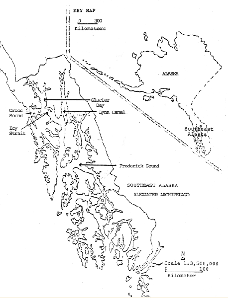
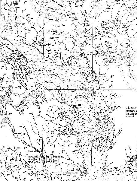
FIGURE 2. Soundings in Fathoms (NOS Chart 17300)
Click on map for larger size.
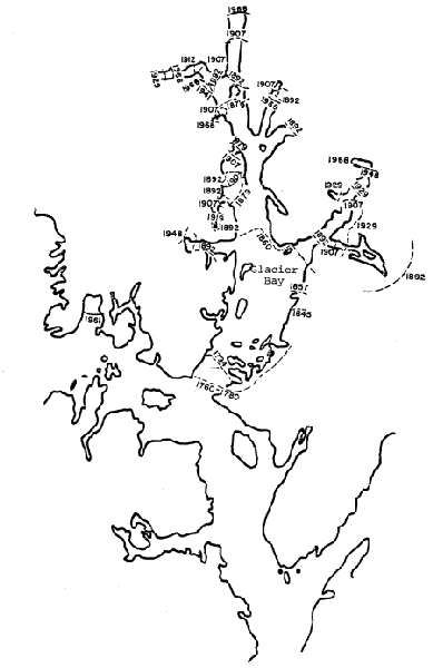
FIGURE 3. GLACIER BAY, ALASKA SHOWING FORMER POSITIONS OF TERMINI 1760-1966 (from Hale and Wright, 1979)
Click on map for larger size.
Glacier Bay[2]
Glacier Bay is located near the north end of the Alexander Archipelago (Figures 1 and 2). The Bay opens into Cross Sound and Icy Strait of the Inside Passage of southeast Alaska. When Vancouver discovered the area in 1780, glacial ice filled the Bay to its mouth (Figure 3). In 1891, when the Bay was first mapped, Muir Inlet was still filled with ice. Today the ice has retreated up the right (Muir Inlet) arm of the "Y" shaped Bay to tide-water levels. Recently, glacial ice has started to readvance in the upper reaches of the west inlets of the Bay.
The Bay is defined by shallow sills at its entrance and the entrance to Muir Inlet. Constricted channels in which tidal currents are locally strong occur between sediment covered shores in the lower end of the Bay and the east (Muir) inlet. Deep, unconstricted bedrock channels and basins with weak currents occur in mid-Bay and the west inlet. These features and the configuration of the bay produce a tidal range of 8 meters. There is reduced mixing of waters within the Bay and between the Bay and Cross Sound/Icy Strait. Annual precipitation up to 4 meters, coupled with glacial melt water, create a surface layer and flow of cold fresh water out of the Bay. Strong flood tides push sea water into the Bay over the sills. The dynamics of the flow may effect the behavior and timing of the movement of whales into (on flood tides) and out of (on ebb tides) the Bay (see below).
During the winter, an increase in sea water flow and mixing occur. Increased nutrient levels and sunlight in spring/summer provide sufficient nutrients and energy for phytoplankton "blooms" to occur. In turn, zooplankters appear, especially in the open areas of mid and lower Bay (e.g., euphausiids) and along glacial ice faces (e.g., mysids and amphipods). By autumn, plankton concentrations diminish as light and nutrient levels decrease. Small schooling fish, (e.g., capelin, Mallotus villosus and Pacific sand lance, Ammodytes hexapterus), feed on the plankton when it becomes available. Both fish and plankton are consumed by humpback whales as well as by other predators. Other marine mammal species reported in the Bay are harbor seals (Phoca vitulina), harbor porpoise (Phocoena phocoena), killer whales (Orcinus orca), and minke whales (Balaenoptera acutorostrata).
Humpback Whales in Glacier Bay[3]
The distribution in and use of Glacier Bay by humpback whales was not well known until Charles and Virginia Jurasz began observations in 1973. Prior to this, only personal recollections of Park Service employees of the occurrence of humpback whales in the 1950's and the 1960's exist. In 1967, 60 identifiable humpback whales were observed in three southeast Alaskan areas, i.e., Lynn Canal, Frederick Sound, and Glacier Bay. The number of identifiable whales remained relatively constant until 1974 in Lynn Canal, and 1978 (July 17) in Glacier Bay (Tables 1-3). In the respective areas, the number of identified whales decreased from 15 and 19 to 1 and 3, respectively. Concurrently, the number of identified whales sighted in Frederick Sound increased.
TABLE 1. Relative abundance and distribution of identified humpback whales in southeast Alaskan waters 1967-79[a]
Year67686970717273747576777879
Glacier Bay 202020202020252525252519/3[b]3
Lynn Canal 15151515151515 1 3 3 31/5 5
Frederick Sound252525252525253540404040/50 80
Total 606060606060656168686860/58 88
TABLE 2. Number of humpback whales (individual census) entering Glacier Bay during "influxes". (modified from Jurasz and Jurasz, 1979)
Year197619771978
First Influx977
Second Influx111716
Seasonal Maximum202423
TABLE 3. Age composition of humpback whales per year in Glacier Bay (modified from Jurasz and Jurasz, 1979)
YEAR197619771978
NO. OF CALVES124
NO. OF IDENTIFIED ADULTS141418
NO. OF JUVENILES 61
TOTAL NO. OF ADULTS191918
Identifiable humpback whales were sighted in Glacier Bay each year, 1976-1977, for a six to twelve week period. In 1978, all but three whales departed the Bay after 16 days. In the summers of 1976-1978 two influxes of whales occurred (Table 2). The Juraszs' define an influx of whales as those whales that enter and remain in the Bay for a minimum of three weeks. The second influx arrived 7-14 days after extreme low tides occurred in late June-early July and presumably moved into the Bay on flood tides. In 1979, a single influx comprised of 3 whales entered the Bay. The age composition of identified whales using Glacier Bay was categorized by the Juraszs' for 1976-1978 (Table 3).
During the period spent in the Bay, humpback whales have been observed to feed on capelin, euphausiids (Euphausia pacifica), and pandalid shrimp (Pandulus borealis). There appear to be three generalized feeding relationships: 1) early-season feeding on shrimp in the upper Bay; 2) mid-season feeding by concentrations of whales on capelin in the lower Bay; and 3) late-season feeding (around August 5) by concentrations of whales on euphausiids in mid-Bay.
Behaviorally, humpback whales appear to lunge up through concentrated schools of prey during mid-season and use "bubble-netting" as a means of concentrating less dense and/or numerically fewer prey earlier and later in the season. In other areas of southeast Alaska, humpbacks are reported to also feed on herring (Clupea harengus pallasi), shrimp, and possibly other small schooling (swarming) prey. The Juraszs' believe that humpbacks establish feeding territories in the Bay, and have described eight "stress behaviors" associated with violations of those territories (Table 4). The data collected by the Juraszs are extensive (including human use of Glacier Bay) but have not yet been completely analyzed.
Human Use of Glacier Bay[4]
John Muir popularized Glacier Bay, leading to tourist activity into the early 1900's, when loose ice resulting from earthquake activity prevented cruise vessels from operating within the Bay. Glacier Bay was designated a National Monument February 26, 1925, the area being added to April 18, 1939.
Vessel and tourist numbers remained low until the late 1960's-early 1970's. Close to 100 percent of the visitors to the Bay use vessels, either entering the Bay aboard them or making use of them to tour the Bay after arriving by aircraft. The Juraszs' developed a classification scheme for vessels and aircraft based upon activities of the craft in the Bay, their size, hull design, and engine characteristics (Table 5).
TABLE 4. Juraszs' description of "stress behavior" (Progressing from the least "stressful" to the most "stressful") (modified from Jurasz and Jurasz, 1979.)
ModeDescription
VocalizationBellowing or trumpeting noise produced by a whale and heard above and below the water. Emanates from the blowhole at the time of the expiration.
BubblingPremature or underwater release of breath in a straight line or as a single "belch" allowing the whale to avoid having a visible blow. Bubbles released usually 2-3 m below the water's surface.
FinningFlipper slapping; the striking of the water's surface with the pectoral fins.
Tail LobbingRaising the flukes well out of the water and crashing or slapping them back flat against the water's surface producing a loud sound.
Tail RakeA subset of the tail lobbing is the rake in which the flukes are raked laterally across the water's surface.
Half or Full Bodied BreachA leap from the water in which a portion of the whale's body emerges from the water only to reenter with a large splash.
AvoidanceThe temporary leaving of an area or a change in the direction of travel.
AbandonmentLeaving an area prematurely and not being seen again for at least one season in that area.
TABLE 5. Juraszs' vessel/aircraft classes (after Jurasz and Jurasz, 1979)
Class 1 Touring Vessel Over 10k Tons
Class 2Touring Vessel 5k-10k tons
Class 3Commercial Fishing/Crabbing
Class 4Charter & Pleasure
Class 5Cabined High RPM Outdrive Units
Class 6Sailboat Using Aux. Power
Class 7Utility Craft, Outboard Engine
Class 8Kayak, Sailboat (no engines)
Class 9Aircraft, Fixed
Class 10 Aircraft, Rotor
Class 11 Aircraft, Jet
Class 12 Hydrofoil
Class 13 Another Humpback
Class 14 Killer whales
Class 15 Minke Whales
Class 16 R/V GINJUR (Juraszs' research vessel)
Class 17 Wake Only
The increase in visitors and vessels to Glacier Bay is presented in Tables 6-8. (Data included in Table 6 cannot be compared to data presented in Table 7 because of difference in methods of data collection, sample area, time, effort, etc.)
Commercial fishing vessel activity in the Bay was probably low until the 1970's. Since 1972 (it is not known whether data are available prior to 1972) commercial fishing vessel visits have fluctuated (Figure 4), but fishing activity has been greatest during the summer months (Figure 5). Sport fishing visits have increased during the same time period (Figure 6).