APPENDIX
Reading edition
A.
METEOROLOGICAL OBSERVATIONS IN BEHAR, AND IN THE VALLEYS OF THE SOANE AND GANGES.
Most of the instruments which I employed were constructed by Mr. Newman, and with considerable care: they were in general accurate, and always extremely well guarded, and put up in the most portable form, and that least likely to incur damage; they were further frequently carefully compared by myself. These are points to which too little attention is paid by makers and by travellers in selecting instruments and their cases. This remark applies particularly to portable barometers, of which I had five at various times. Although there are obvious defects in the system of adjustment, and in the method of obtaining the temperature of the mercury, I found that these instruments invariably worked well, and were less liable to derangement and fracture than any I ever used; the best proof I can give of this is that I preserved three uninjured during nearly all my excursions, left two in India, and brought a third home myself that had accompanied me almost throughout my journey.
In very dry climates these and all other barometers are apt to leak, from the contraction of the box-wood plug through which the tube passes into the cistern. This must, in portable barometers, in very dry weather, be kept moist with a sponge. A small iron bottle of pure mercury to supply leakage should be supplied with every barometer, as also a turnscrew. The vernier plate and scale should be screwed, not soldered on the metal sheath, as if an escape occurs in the barometer-case the solder is acted upon at once. A table of corrections for capacity and capillarity should accompany every instrument, and simple directions, etc., in cases of trifling derangement, and alteration of neutral point.
The observations for temperature were taken with every precaution to avoid radiation, and the thermometers were constantly compared with a standard, and the errors allowed for. The maximum thermometer with a steel index, I found to be extremely liable to derangement and very difficult to re-adjust. Negretti’s maximum thermometer was not known to me during my journey. The spirit minimum thermometers again, are easily set to rights when out of order, but in every one (of six or seven) which I took to India, by several makers, the zero point receded, the error in some increasing annually, even to –6° in two years. This seems due to a vaporisation of the spirit within the tube. I have seen a thermometer of this description in India, of which the spirit seemed to have retired wholly into the bulb, and which I was assured had never been injured. In wet-bulb observations, distilled water or rain, or snow water was used, but I never found the result to differ from that obtained by any running fresh water, except such as was polluted to the taste and eye.
The hours of observation selected were at first sunrise, 9 a.m., 3 p.m., sunset, and 9 p.m., according to the instructions issued to the Antarctic expedition by the Royal Society. In Sikkim, however, I generally adopted the hours appointed at the Surveyor General’s office, Calcutta; viz., sunrise, 9h. 50m. a.m., noon, 2h. 40m. p.m., 4 p.m., and sunset, to which I added a 10 p.m. observation, besides many at intermediate hours as often as possible. Of these the 9h. 50m. a.m. and 4 p.m. have been experimentally proved to be those of the maximum and minimum of atmospheric pressure at the level of the sea in India, and I did not find any great or marked deviation from this at any height to which I attained, though at 15,000 or 16,000 feet the morning maximum may occur rather earlier.
The observations for nocturnal (terrestrial) radiation were made by freely suspending thermometers with naked bulbs, or by laying them on white cotton, wool, or flannel; also by means of a thermometer placed in the focus of a silvered parabolic reflector. I did not find that the reflector possessed any decided advantage over the white cotton: the means of a number of observations taken by each approximated closely, but the difference between individual observations often amounted to 2°.
Observations again indicative of the radiation from grass, whether dewed or dry, are not strictly comparable; not only does the power of radiation vary with the species, but much more with the luxuriance and length of the blades, with the situation, whether on a plane surface or raised, and with the subjacent soil. Of the great effect of the soil I had frequent instances; similar tufts of the same species of grass radiating more powerfully on the dry sandy bed of the Soane, than on the alluvium on its banks; the exposure being equal in both instances. Experiments for the surface-temperature of the soil itself, are least satisfactory of any:—adjoining localities being no less affected by the nature, than by the state of disintegration of the surface, and by the amount of vegetation in proximity to the instrument.
The power of the sun’s rays in India is so considerable, and protracted through so long a period of the day, that I did not find the temperature of springs, or of running water, even of large deep rivers, so constant as was to be expected.
The temperature of the earth was taken by sinking a brass tube a yard long in the soil.
A thermometer with the bulb blackened affords the only means the traveller can generally compass, of measuring the power of the sun’s rays. It should be screened or put in a blackened box, or laid on black wool.
A good Photometer being still a desideratum, I had recourse to the old wedge of coloured glass, of an uniform neutral tint, the distance between whose extremes, or between transparency and total opacity, was one foot. A moveable arm carrying a brass plate with a slit and a vernier, enables the observer to read off at the vanishing point of the sun’s limb, to one five-hundredth of an inch. I generally took the mean of five readings as one, and the mean of five of these again I regarded as one observation; but I place little dependence upon the results. The causes of error are quite obvious. As far as the effects of the sun’s light on vegetation are concerned, I am inclined to think that it is of more importance to register the number of hours or rather of parts of each hour, that the sun shines, and its clearness during the time. To secure valuable results this should be done repeatedly, and the strength of the rays by the black-bulb thermometer registered at each hour. The few actinometer observations will be found in another part of the Appendix.
The dew-point has been calculated from the wet-bulb, by Dr. Apjohn’s formula, or, where the depression of the barometer is considerable, by that as modified by Colonel Boileau.[395] The saturation-point was obtained by dividing the tension at the dew-point by that at the ordinary temperature, and the weight of vapour, by Daniell’s formula.
The following summary of meteorological observations is alluded to at vol. i., p. 15.
I.—Table-land of Birbhoom and Behar, from Taldanga to Dunwah. Average elevation 1,135 feet.
It is evident from these observations, that compared with Calcutta, the dryness of the atmosphere is the most remarkable feature of this table-land, the temperature not being high; and to this, combined with the sterility of the soil over a great part of the surface, must be attributed the want of a vigorous vegetation. Though so favourably exposed to the influence of nocturnal radiation, the amount of the latter is small. The maximum depression of a thermometer laid on grass never exceeded 10°, and averaged 7°; whereas the average depression of the dew-point at the same hour amounted to 25° in the morning. Of course no dew was deposited even in the clearest star-light night.
February 1848
Hour Sunrise 9 a.m. 3 p.m. 9 p.m.
TEMPERATURE Mean Max. Min. Range 56·6 65·2 46·3 18·9 70·1 77·0 61·2 15·8 75·5 81·7 65·2 16·5 61·7 66·2 55·5 10·7
WET-BULB Mean Max. Depression Min. Depression 48·2 12·5 6·0 53·7 19·3 14·3 55·3 22·5 16·7 49·3 20·5 9·0
Elasticity of Vapour ·276 ·264 ·248 ·248
DEW-POINT Mean Max. Min. Max. Depression Min. Depression 39·5 52·0 23·3 31·7 10·4 37·9 52·7 24·5 39·2 24·3 36·0 46·8 24·3 48·4 34·9 36·1 50·0 [396]9·1 56·9 16·2
Weight of Vapour in cubic feet 3·088 2·875 2·674 2·745
SATURATION Mean Max. Min. ·550 ·680 ·330 ·330 ·450 ·260 ·260 ·320 ·190 ·410 ·590 ·140
Number of observations 7 7 7 10
Extreme variations of temperature 35·4°
Extreme variations of relative humidity ·540
Extreme diff. solar and nocturnal radiation 96·5°
SOLAR RADIATION
MORNING
Hour Th. Black Bulb Diff. Phot.
9.30 a.m. 10 a.m. 10 a.m. 9 a.m. 9 a.m. 9 a.m. 77·0 69·5 77·0 63·5 61·2 67·0 130 124 137 94 106 114 53·0 54·5 60·0 30·5 44·8 47·0 -- 10·320 -- 10·230 -- 10·350
Mean 69·2 117·5 48·1 10·300
AFTERNOON
Hour Th. Black Bulb Diff. Phot.
3.30 p.m. 3 p.m. 3 p.m. 3.30 p.m. 3 p.m. 81·7 80·5 81·5 72·7 72·5 109 120 127 105 110 27·3 39·5 45·5 32·3 37·5 -- 10·320 10·330 10·230 10·390
Mean 77·8 114·2 68·4 10·318
NOCTURNAL RADIATION
SUNRISE
Exposed thermometer On earth On grass
Temperature Mean diff. from air Max. diff. from air Number of observations 51·1 4·0 9·0 6 48·3 2·5 3·7 3 46·6 6·2 9·0 5
NINE P.M.
Exposed thermometer On earth On grass
Temperature Mean diff. from air Max. diff. from air Number of observations 56·4 5·3 7·5 7 53·8 4·9 5·5 6 54·4 7·2 10·0 7
On one occasion, and that at night, the dew-point was as low as 11·5°, with a temperature of 66°, a depression rarely equalled at so low a temperature: this phenomenon was transient, and caused by the passage of a current of air loaded with dust, whose particles possibly absorbed the atmospheric humidity. From a comparison of the night and morning observations of thermometers laid on grass, the earth, and freely exposed, it appears that the grass parts with its heat much more rapidly than the earth, but that still the effect of radiation is slight, lowering its temperature but 2° below that of the freely exposed thermometer.
As compared with the climate of Calcutta, these hills present a remarkable contrast, considering their proximity in position and moderate elevation.
The difference of temperature between Calcutta and Birbhoom, deduced from the sunrise, morning and afternoon observations, amounts to 4°, which, if the mean height of the hills where crossed by the road, be called 1,135 feet, will be equal to a fall of one degree for every 288 feet.
In the dampness of its atmosphere, Calcutta contrasts very remarkably with these hills; the dew-point on the Hoogly averaging 51·3°, and on these hills 38°, the corresponding saturation-points being 0·559 and 0·380.
The difference between sunrise, forenoon and afternoon dew-points at Calcutta and on the hills, is 13·6° at each observation; but the atmosphere at Calcutta is relatively drier in the afternoon than that of the hills; the difference between the Calcutta sunrise and afternoon saturation-point being 0·449, and that between the hill sunrise and afternoon, 0·190. The march of the dew-point is thus the same in both instances, but owing to the much higher temperature of Calcutta, and the greatly increased tension of the vapour there, the relative humidity varies greatly during the day.
In other words, the atmosphere of Calcutta is loaded with moisture in the early morning of this season, and is relatively dry in the afternoon: in the hills again, it is scarcely more humid at sunrise than at 3 p.m. That this dryness of the hills is partly due to elevation, appears from the disproportionately moister state of the atmosphere below the Dunwah pass.
II.—Abstract of the Meteorological observationsctaken in the Soane Valley (mean elevation 422 feet).
The difference in mean temperature (partly owing to the sun’s more northerly declination) amounts to 2·5° of increase in the Soane valley, above that of the hills. The range of the thermometer from day to day was considerably greater on the hills (though fewer observations were there recorded): it amounted to 17·2° on the hills, and only 12·8° in the valley. The range from the maximum to the minimum of each day amounts to the same in both, above 20°. The extreme variations in temperature too coincide within 1·4°.
The hygrometric state of the atmosphere of the valley differs most decidedly from that of the hills. In the valley dew is constantly formed, which is owing to the amount of moisture in the air, for nocturnal radiation is more powerful on the hills. The sunrise and 9 p.m. observations in the valley, give a mean depression of the dew-point below the air of 12·3°, and those at the upper level of 21·2°, with no dew on the hills and a copious deposit in the valley. The corresponding state of the atmosphere as to saturation is 0·480 on the hills and 0·626 in the valley.
The vegetation of the Soane valley is exposed to a less extreme temperature than that of the hills; the difference between solar and nocturnal radiation amounting here only to 80·5°, and on the hills to 96·5°. There is no material difference in the power of the sun’s rays at the upper and lower levels, as expressed by the blackbulb thermometer, the average rise of which above one placed in the shade, amounted to 48° in both cases, and the maximum occurred about 11 a.m. The decrease of the power of the sun’s rays in the afternoon is much the most rapid in the valley, coinciding with a greater reduction of the elasticity of vapour and of humidity in the atmosphere.
The photometer observations show a greater degree of sun’s light on the hills than below, but there is not at either station a decided relation between the indications of this instrument and the black-bulb thermometer. From observations taken elsewhere, I am inclined to attribute the excess of solar light on the hills to their elevation; for at a far greater elevation I have met with much stronger solar light, in a very damp atmosphere, than I ever experienced in the drier plains of India. In a damp climate the greatest intensity may be expected in the forenoon, when the vapour is diffused near the earth’s surface; in the afternoon the lower strata of atmosphere are drier, but the vapour is condensed into clouds aloft which more effectually obstruct the sun’s rays. On the Birbhoom and Behar hills, where the amount of vapour is so small that the afternoon is but little drier than the forenoon, there is little difference between the solar light at each time. In the Soane valley again, where a great deal of humidity is removed from the earth’s surface and suspended aloft, the obstruction of the sun’s light is very marked.
DUNWAH TO SOANE RIVER, AND UP SOANE TO TURA
February 10–19th
Hour Sunrise 9 a.m. 3 p.m. 9 p.m.
TEMPERATURE Mean Max. Min. Range 57·6 62·0 53·5 8·5 74·0 81·0 63·5 17·5 77·6 87·5 71·0 16·5 64·5 68·7 60·0 8·7
WET-BULB Mean Max. Depression Min. Depression 51·7 8·5 3·8 59·5 18·5 4·0 59·9 26·0 6·8 55·5 12·5 2·5
Elasticity of Vapour 0·352 0·382 0·357 0·370
DEW-POINT Mean Max. Min. Max. Depression Min. Depression 46·1 53·6 40·6 16·9 7·0 48·5 56·7 38·0 33·5 6·8 46·4 60·0 36·0 44·2 11·0 47·5 55·6 41·0 24·1 4·4
Weight of Vapour in cubic feet 3·930 4·066 3·658 4·014
SATURATION Mean Max. Min. ·680 ·787 ·566 ·460 ·818 ·338 ·352 ·703 ·237 ·572 ·860 ·452
Number of observations 10 8 9 10
Extreme variations of temperature 34·0°
Extreme variations of relative humidity ·623
Extreme diff. solar and nocturnal radiation 80·5°
NOCTURNAL RADIATION
SUNRISE
Exposed thermometer On earth On grass
Temperature Mean diff. from air Max. diff. from air Number of observations 53·2 4·5 8·5 9 54·0 3·7 9·0 9 51·5 6·2 7·5 8
NINE P.M.
Exposed thermometer On earth On grass
Temperature Mean diff. from air Max. diff. from air Number of observations 59·9 4·6 11·5 10 60·7 3·8 10·5 10 56·4 8·1 13·5 10
SOLAR RADIATION
MORNING
Time Th. Black Bulb Diff. Phot.
9 a.m. 11 a.m. 10.30 a.m. 10 a.m. 10 a.m. 10.30 a.m. 70·0 81·0 71·5 72·0 80·0 78·0 125 119 126 117 122 128 55·0 38·0 54·5 45·0 42·0 50·0 10·300 10·230 10·300 10·220 -- --
Mean 75·4 122·8 47·4 10·262
AFTERNOON
Time Th. Black Bulb Diff. Phot.
4 p.m. 3 p.m. 3 p.m. 3 p.m. 76·5 80·0 76·0 87·5 90 105 102 126 13·5 25·0 26·0 38·5 -- 10·210 10·170 --
Mean 80·0 105·7 25·7 10·190
NOCTURNAL RADIATION FROM PLANTS
SUNRISE NINE P.M.
Air temperature 59·5 55·0 67·5 67·0 64·3
Calotropis -- 49·5 -- -- 58·5
Difference -- 5·5 -- -- 5·83
Argemone 57·0 47·0 53·0 56·0 57·0
Difference 2·5 8·0 14·0 11·0 7·3
III.—VALLEY OF SOANE RIVER, TURA TO SULKUN (Mean elev. 517 feet)
February 20th to March 3rd
Hour Sunrise 9 a.m. 3 p.m. 9 p.m.
TEMPERATURE Mean Max. Min. Range 56·8 70·0 50·0 20·0 82·0 89·0 69·0 20·0 88·6 94·7 81·5 13·2 68·0 74·0 61·0 13·0
WET-BULB Mean Max. Depression Min. Depression 52·5 10·0 1·5 61·2 24·3 12·0 62·4 30·2 14·5 56·8 15·0 6·0
Elasticity of Vapour 0·380 0·385 0·289 0·369
DEW-POINT Mean Max. Min. Max. Depression Min. Depression 48·3 53·1 41·1 17·3 5·4 48·7 60·2 40·3 45·2 22·0 40·8 50·9 32·3 57·2 25·1 47·4 51·8 42·6 27·1 10·2
Weight of Vapour in cubic feet 4·240 4·097 2·975 3·933
SATURATION Mean Max. Min. ·754 ·831 ·570 ·342 ·488 ·226 ·211 ·598 ·154 ·511 ·703 ·415
Number of observations 12 11 11 11
Extreme variation of temperature 44·7°
Extreme variation of relative humidity ·677
Extreme diff. solar and nocturnal radiation 100°
NOCTURNAL RADIATION
SUNRISE
Exposed thermometer On earth On grass
Temperature Mean diff. from air Max. diff. from air Number of observations 51·7 5·1 8·0 9 52·4 3·4 7·0 9 48·8 7·0 11·5 9
NINE P.M.
Exposed thermometer On earth On grass
Temperature Mean diff. from air Max. diff. from air Number of observations 61·2 6·8 10·5 10 64·3 4·6 8·5 9 55·8 11·8 17·0 9
SOLAR RADIATION
MORNING
Time Temp. Black Bulb Diff. Phot.
11.30 a.m. 10.30 a.m. Noon Noon Noon Noon 85·5 89·0 90·0 85·0 86·0 90·0 129 132 132 130 138 138 44·5 43·0 42·0 45·0 52·0 48·0 -- -- 10·140 -- -- --
Mean 87·6 133 45·8 10·140
AFTERNOON
Time Temp. Black Bulb Diff. Phot.
3 p.m. -- -- -- -- 85·5 92·5 92·0 89·5 93·5 116 128 120 128 144 30·5 35·5 28·0 38·5 50·5 -- -- -- -- --
Mean 90·6 127 36·6 --
NOCTURNAL RADIATION FROM PLANTS
SUNRISE
Air temperature Barley Diff. Calo- tropis Diff. Arge- mone Diff.
61·0 57·0 57·0 58·5 57·0 50·0 50·5 56·0 56 46 52 52 52 45 43 -- 5·0 11·0 5·0 6·5 5·0 5·0 7·5 -- 56·5 48·0 -- -- -- 45·5 -- -- 4·5 9·0 -- -- -- 4·5 -- -- 57·0 50·0 50·0 -- -- -- -- 49·0 4·0 7·0 7·0 -- -- -- -- 7·0
55·9 49·4 6·4 50·0 6·0 51·5 6·2
NINE P.M.
Air temperature Barley Diff. Calo- tropis Diff. Arge- mone Diff.
68·5 70·0 69·0 74·0 62·5 67·5 61·0 -- -- -- -- 51·5 67·5 50·0 -- -- -- -- 11·0 10·0 11·0 -- 65·0 57·0 59·0 -- 62·5 -- -- 5·0 12·0 15·0 -- 5·0 -- 56·0 67·0 57·0 -- -- -- -- 12·5 3·0 12·0 -- -- -- --
67·5 56·3 10·7 60·9 9·3 60·0 9·2
The upper course of the Soane being in some places confined, and exposed to furious gusts from the gullies of the Kymore hills, and at others expanding into a broad and flat valley, presents many fluctuations of temperature. The mean temperature is much above that of the lower parts of the same valley (below Tura), the excess amounting to 5.4°. The nights and mornings are cooler, by 1·2°, the days hotter by 10°. There were also 10° increase of range during the thirteen days spent there; and the mean range from day to day was nearly as great as it was on the hills of Bengal.
There being much exposed rock, and the valley being swept by violent dust-storms, the atmosphere is drier, the mean saturation point being ·454, whereas in the lower part of the Soane’s course it was ·516.
A remarkable uniformity prevails in the depression of thermometers exposed to nocturnal radiation, whether laid on the earth, grass, or freely exposed; both the mean and maximum indication coincide very nearly with those of the lower Soane valley and of the hills. The temperature of tufts of green barley laid on the ground is one degree higher than that of short grass; Argemone and Calotropis leaves maintain a still warmer temperature; from the previous experiments the Argemone appeared to be considerably the cooler, which I was inclined to attribute to the smoother and more shining surface of its leaf, but from these there would seem to be no sensible difference between the radiating powers of the two plants.
IV.—TABLE-LAND OF KYMORE HILLS (Mean elev. 979 feet)
February 20th to March 3rd
Hour Sunrise 9 a.m. 3 p.m. 9 p.m.
TEMPERATURE Mean Max. Min. Range 65·3 69·0 57·5 11·5 81·6 83·5 79·5 4·0 88·1 90·0 84·5 5·5 71·1 76·0 68·0 8·0
WET-BULB Mean Max. Depression Min. Depression 57·7 8·0 6·0 65·3 19·0 14·0 63·3 26·5 21·5 60·3 13·0 8·3
Elasticity of Vapour 0·428 0·468 0·324 0·433
DEW-POINT Mean Max. Min. Max. Depression Min. Depression 52·0 55·5 45·9 14·1 11·6 54·5 57·9 49·0 33·0 12·9 43·7 47·8 37·9 46·6 42·2 52·3 56·7 46·8 21·9 13·8
Weight of Vapour in cubic feet 4·710 5·000 3·417 4·707
SATURATION Mean Max. Min. ·647 ·741 ·648 ·421 ·479 ·344 ·240 ·295 ·214 ·542 ·643 ·491
Number of observations 4 3 3 4
Extreme variation of temperature 32·5°
Extreme variation of relative humidity ·527
Extreme diff. solar and nocturnal radiation 110·5°
NOCTURNAL RADIATION
SUNRISE
Exposed thermometer On earth On grass
Temperature Mean diff. from air Max. diff. from air Number of observations 59·5 3·5 3·5 2 56·0 1·5 1·5 1 54·7 8·2 8·5 2
NINE P.M.
Exposed thermometer On earth On grass
Temperature Mean diff. from air Max. diff. from air Number of observations 71·5 3·3 7·0 3 62·5 5·5 5·5 1 61·0 8·2 11·0 2
The rapid drying of the lower strata of the atmosphere during the day, as indicated by the great decrease in the tension of the vapour from 9 a.m. to 3 p.m., is the effect of the great violence of the north-west winds.
From the few days’ observations taken on the Kymore hills, the temperature of their flat tops appeared 5° higher than that of the Soane valley, which is 500 feet below their mean level. I can account for this anomaly only on the supposition that the thick bed of alluvium, freely exposed to the sun (not clothed with jungle), absorbs the sun’s rays and parts with its heat slowly. This is indicated by the increase of temperature being due to the night and morning observations, which are 3·1° and 8·5° higher here than below, whilst the 9 a.m. and 3 p.m. temperatures are half a degree lower.
The variations of temperature too are all much less in amount, as are those of the state of the atmosphere as to moisture, though the climate is rather damper.
On the subject of terrestrial radiation the paucity of the observations precludes my dwelling. Between 9 p.m. and sunrise the following morning I found the earth to have lost but 6·5° of heat, whereas a mean of nine observations at the same hours in the valley below indicated a loss of 12°.
Though the mean temperature deduced from the few days I spent on this part of the Kymore is so much above that of the upper Soane valley, which it bounds, I do not suppose that the whole hilly range partakes of this increase. When the alluvium does not cover the rock, as at Rotas and many other places, especially along the southern and eastern ridges of the ghats, the nights are considerably cooler than on the banks of the Soane; and at Rotas itself, which rises almost perpendicularly from the river, and is exposed to no such radiation of heat from a heated soil as Shahgunj is, I found the temperature considerably below that of Akbarpore on the Soane, which however is much sheltered by an amphitheatre of rocks.
V.—Mirzapore on the Ganges.
During the few days spent at Mirzapore, I was surprised to find the temperature of the day cooler by nearly 4° than that of the hills above, or of the upper part of the Soane valley, while the nights on the other hand were decidedly warmer. The dew-point was even lower in proportion, 7·6°, and the climate consequently drier. The following is an abstract of the observations taken at Mr. Hamilton’s house on the banks of the Ganges (p. 363).
It is remarkable that nocturnal radiation as registered at sunrise is much more powerful at Mirzapore than on the more exposed Kymore plateau; the depression of the thermometer freely exposed being 3° greater, that laid on bare earth 6°, and that on the grass 1·4° greater, on the banks of the Ganges.
During my passage down the Ganges the rise of the dew-point was very steady, the maximum occurring at the lowest point on the river, Bhaugulpore, which, as compared with Mirzapore, showed an increase of 8° in temperature, and of 30·6° in the rise of the dew-point. The saturation-point at Mirzakore was ·331, and at the corresponding hours at Bhaugulpore ·742.
MIRZAPORE (Mean elev. 362 feet)
March 9th to 13th, 1848
Hour Sunrise 9 a.m. 3 p.m. 9 p.m.
TEMPERATURE Mean Max. Min. Range 61·1 63·0 58·0 5·0 76·1 83·0 71·0 12·0 86·0 -- -- -- 76·0 -- -- --
WET-BULB Mean Max. Depression Min. Depression 48·8 51·5 47·0 58·5 56·5 51·7 61·7 24·3 -- 63·5 12·5 --
Elasticity of Vapour ·236 ·302 ·295 ·480
DEW-POINT Mean Max. Min. Max. Depression Min. Depression 34·3 39·7 29·7 32·8 23·8 41·9 -- -- 52·3 15·7 41·3 -- -- 44·7 -- 55·2 -- -- 20·8 --
Weight of Vapour in cubic feet 2·574 3·271 3·089 5·127
SATURATION Mean Max. Min. ·405 ·450 ·327 ·324 ·603 ·176 ·264 -- -- ·511 -- --
Number of observations 3 3 1 1
Air in shade Sunrise Exposed Therm. Diff. Exposed on earth Diff. Exposed on grass Diff.
60·0 62·5 63·0 58·0 55·0 54·5 55·5 53·0 5·0 8·0 7·5 5·0 -- 56·0 50·5 54·0 -- 6·5 12·5 4·0 52·0 52·5 50·5 50·0 8·0 10·0 12·5 8·0
60·9 54·6 6·4 53·5 7·7 51·3 9·6
B.
ON THE MINERAL CONSTITUENTS AND ALGÆ OF THE HOT-SPRINGS OF BEHAR, THE HIMALAYA, AND OTHER PARTS OF INDIA, ETC., INCLUDING NOTES ON THE FUNGI OF THE HIMALAYA. (By Dr. R. D. Thomson and the Rev. M. J. Berkeley, M.A., F.L.S.)
The following remarks, for which I am indebted to the kindness of the able chemist and naturalist mentioned above, will be highly valued, both by those who are interested in the many curious physiological questions involved in the association of the most obscure forms of vegetable life with the remarkable phenomena of mineral springs; or in the exquisitely beautiful microscopic structure of the lower Algæ, which has thrown so much light upon a branch of natural history, whose domain, like that of astronomy, lies to a great extent beyond the reach of the unassisted eye.—J.D.H.
1. Mineral water, Soorujkoond, Behar (vol. i., p. 27), contains chloride of sodium and sulphate of soda.
2. Mineral water, hot springs, Yeumtong, altitude 11,730 feet (see vol. ii., p. 117). Disengages sulphuretted hydrogen when fresh.—This water was inodorous when the bottle was opened. The saline matter in solution was considerably less than in the Soorujkoond water, but like that consisted of chloride of sodium and sulphate of soda. Its alkaline character suggests the probability of its containing carbonate of soda, but none was detected. The rocks decomposed by the waters of the spring consist of granite impregnated with sulphate of alumina. It appears that in this case the sulphurous waters of Yeumtong became impregnated in the air with sulphuric acid, which decomposed the felspar,[397] and united with its alumina. I found traces only of potash in the salt.
Sulphuretted hydrogen waters appear to give origin to sulphuric acid, when the water impregnated with the gas reaches the surface; and I have fine fibrous specimens of sulphate of lime accompanied with sulphur, from the hot springs of Pugha in west Tibet, brought by Dr. T. Thomson.
3. Mineral water, Momay hot springs, (vol. ii., p. 133).—When the bottle was uncorked, a strong smell of sulphuretted hydrogen was perceived. The water contains about twenty-five grains per imp. gallon, of chloride of sodium, sulphate and carbonate of soda; the reaction being strongly alkaline when the solution was concentrated.
4. Effloresced earth from Behar (vol. i., p. 13), consists of granite sand, mixed with sesquicarbonate of soda.
On the Indian Algæ which occur principally in different parts of the Himalayan Range, in the hot-springs of Soorujkoond in Bengal, Pugha in Tibet, and Momay in Sikkim; and on the Fungi of the Himalayas. By the Rev. M. J. Berkeley, M.A.
It is not my intention in the present appendix to give specific characters or even accurately determined specific names to the different objects within its scope, which have come under investigation, as collected by Dr. Hooker and Dr. Thomson. To do so would require far more time than I have at present been able to devote to the subject, for though every species has been examined microscopically, either by myself or Mr. Broome, and working sketches secured at the same time, the specific determination of fresh water Algæ from Herbarium specimens is a matter which requires a very long and accurate comparison of samples from every available locality, and in the case of such genera as Zygnema, Tyndaridea, and Conferva, is, after all, not a very satisfactory process.
The object in view is merely to give some general notion of the forms which presented themselves in the vast districts visited by the above-mentioned botanists, comprising localities of the greatest possible difference as regards both temperature and elevation; but more especially in the hot-springs which occur in two distant parts of the Himalayas and in Behar, and these again under very different degrees of elevation and of extrinsic temperature.
The Algæ from lower localities are but few in number, and some of these of very common forms. We have for instance from the Ganges, opposite Bijnour, a Batrachospermum and Conferva crispata, the former purple below, with specimens of Chantransia, exactly as they might occur in the Thames. The Conferva, or more properly Cladophora, which occurs also under various forms, at higher elevations, as in the neighbourhood of Simla and Iskardo, swarms with little parasites, but of common or uninteresting species. In the Bijnour specimens, these consist of common forms of Synedra, Meridion circulare, and a Cymbella, on others from Dacca, there are about three species of Synedra,[398] a minute Navicula and Gomphonema curvatum. Nothing, in fact, can well be more European. One splendid Alga, however, occurs at Fitcoree, in Behar, on the banks of nullahs, which are dry in hot weather, forming a purple fleece of coarse woolly hairs, which are singularly compressed, and of extreme beauty under the microscope, from the crystalline green of the articulated string which threads the bright red investing sheath. This curious Alga calls to mind in its colouring Cænocoleus Smithii, figured in English Botany, t. 2940, but it has not the common sheath of that Alga, and is on a far larger scale. One or two other allied forms, or species, occur in East Nepal, to which I purpose giving, together with the Behar plant, the generic name of Erythronema. From the Soane River, also, is an interesting Alga, belonging to the curious genus Thwaitesia, in which the division of the endochrome in the fertile cells into four distinct masses, sometimes entirely free, is beautifully marked. In some cases, indeed, instead of the ordinary spores, the whole moss is broken up into numerous bodies, as in the fertile joints of Ulothrix, and probably, as in that case, the resultant corpuscles are endowed with active motion. In Silhet, again, is a magnificent Zygnema, allied to Z. nitidum, with large oval spores, about 1/285 part of an inch long, and a dark golden brown colour, and containing a spiral green endochrome.
Leaving, however, the lower parts of India, I shall first take the species which occur in Khasia, Sikkim, Eastern Nepal, and the adjoining parts of Tibet.
In the hot valleys of the Gtreat Rungeet, at an elevation of about 2000 feet, we have the Erythronema, but under a slightly different form; at Nunklow, at about the same height; in Khasia, again, at twice that elevation; in Eastern Nepal, at 12,000; and, finally, at Momay, reaching up to 16,000 feet. In water, highly impregnated with oxide of iron, at 4000 feet in Sikkim, a Leptothrix occurred in great abundance, coloured with the oxide, exactly as is the case with Algæ which grow in iron springs in Europe. At elevations between 5000 and 7000 feet, several European forms occur, consisting of Ulothrix, Zygnema, Oscillatoria, Lyngbya, Sphærozyga, Scytonema, Conferva, and Cladophora. The species may indeed not be identical with European species, but they are all more or less closely allied to well-known Hydrophytes. One very interesting form, however, either belonging to the genus Zygnema, or possibly constituting a distinct genus, occurs in streams at 5000 feet in Sikkim, consisting of highly gelatinous threads of the normal structure of the Zygnema, but forming a reticulated mass. The threads adhere to each other laterally, containing only a single spiral endochrome, and the articulations are very long. Amongst the threads are mixed those of some species of Tyndaridea. There is also a curious Hormosiphon, at a height of 7000 feet; forming anastomosing gelatinous masses. A fine new species of Lyngbya extends up as high as 11,000 feet. At 13,000 feet occurs either some simple Conferva or Zygnema, it is doubtful which from the condition of the specimens; and at the same elevation, in the nearly dry bed of the stream which flows from the larger lake at Momay, amongst flat cakes, consisting of felspathic silt from the glaciers above, and the débris of Algæ, and abounding in Diatomaceæ, some threads of a Zygnema. At 17,000 feet, an Oscillatoria, attached or adherent to Zannichellia; and, finally, on the bare ground, at 18,000 feet, on the Donkia mountains, an obscure species of Cænocoleus. On the surface of the glaciers at Kinchinjhow, on silt, there is a curious Palmella, apparently quite distinct from any European form.
Amongst the greater part of the Algæ, from 4000 feet to 18,000 feet, various Diatomaceæ occur, which will be best noticed in a tabular form, as follows; the specific name, within brackets, merely indicating the species to which they bear most resemblance:—
Himantidium (Soleirolii) Odontidium (hiemale, forma minor) Epithemia, n. sp. Cymbella Navicula, n. sp. Tabillaria (flocculosa Odontidium (hiemale) Himantidium Odontidium (turgidulum) Epithemia (ocellata) Fragillaria Odontidium (turgidulum) Dictyocha (gracilis) Odontidium (hiemale) 4000 to 7000 feet 5000 to 7000 feet 7000 feet — — 6000 to 7000 feet 11,000 feet 16,000 feet 17,000 feet — 18,000 feet — — — Sikkim Sikkim Sikkim Sikkim Sikkim Sikkim Sikkim Momay Momay Tibet Momay Momay Momay Kinchinjhow
We now turn to those portions of Tibet or the neighbouring regions, explored by Dr. Thomson and Captain Strachey. The principal feature in the Algology is the great prevalence of species of Zygnema and Tyndaridea, which occur under a variety of forms, sometimes with very thick gelatinous coats. In not a single instance, however, is there the slightest tendency to produce fructification. Conferva crispata again, as mentioned above, occurs in several localities; and in one locality a beautiful unbranched Conferva, with torulose articulations. At Iskardo, Dr. Thomson gathered a very gelatinous species of Draparnaldia, or more properly, a Stygeoclonium, if we may judge from a little conglomeration of cells which appeared amongst the threads. A Tetraspora in Piti, an obscure Tolypothrix, and one or two Oscillatoriæ, remarkable for their interrupted mode of growth, complete the list of Algæ, with the exception of one, to be mentioned presently; as also of Diatomaceæ, and of the species of Nostoc and Hormosiphon, which occurred in great profusion, and under several forms, sometimes attaining a very large size (several inches across), especially in the districts of Le and Piti, and where the soil or waters were impregnated with saline matters. It is well known that some species of Nostoc form an article of food in China, and one was used for that purpose in a late Arctic expedition, as reported by Dr. Sutherland; but it does not seem that any use is made of them in Tibet, though probably all the large species would form tolerable articles of food, and certainly, from their chemical composition, prove very nutritious. One species is mentioned by Dr. Thomson as floating, without any attachment, in the shallow water of the pools scattered over the plains, on the Parang River, separated only by a ridge of mountains from Piti, broad and foliaceous, and scarcely different from the common Nostoc, which occurs in all parts of the globe. I must not, however, neglect to record a very singular new genus, in which the young threads have the characters of Tyndaridea, but, after a time, little swellings occur on their sides, in which a distinct endochrome is formed, extending backwards into the parent endochrome, separated from it by a well defined membrane, and producing, either by repeated pullulation, a compound mass like that of Calothrix, or simply giving rise to a forked thread. In the latter case, however, there is no external swelling, but a lateral endochrome is formed, which, as it grows, makes its way through an aperture, whose sides are regularly inflected. I have given to this curious production the name of Cladozygia Thomsoni.
The whole of the above Algæ occurred at heights varying from 10,000 to 15,500 feet. As in the Southern Himalayan Algæ, the specimens were infested with many Diatomaceæ, amongst which the most conspicuous were various Cymbellæ and Epithemiæ. The following is a list of the species observed.
Cymbella (gastroides). Cymbella (gracilis). Cymbella (Ehrenbergii) and three others. Odontidium (hiemale). Odontidium (mesodon). Odontidium n. sp. Epithemia n. sp. Synedra (arcus). Synedra (tenuis). Synedra (æqualis). Denticula (obtusa). Gomphonema (abbreviatum). Meridion circulare.
There is very little identity between this list and that before given from the Southern Himalayas, as is the case also with the other Algæ. Till the species, however, have been more completely studied, a very accurate comparison cannot be made.
In both instances the species which grow in hot springs have been reserved in order to make their comparison more easy. I shall begin in an inverse order, with those of the springs of Pugha in Tibet, which attain a temperature of 174°. Two Confervæ only occur in the specimens which have been preserved, viz., an Oscillatoria allied to that which I have called O. interrupta, and a true Conferva extremely delicate with very long articulations, singularly swollen at the commissures. The Diatomaceæ are:—
Odontidium (hiemale). Odontidium (mesodon). Odontidium n. sp., same as at Piti on Conferva. Denticula (obtusa). Navicula. Cymbella, three species. Epithemia.
Scarcely any one of these except the Navicula is peculiar to the locality. A fragment apparently of some Closterium, the only one which I have met with in the collection, accompanies one of the specimens.
The hot springs of Momay, (temp. 110°) at 16,000 feet, produce a golden brown Cænocoleus representing a small form of C. cirrhosus, and a very delicate Sphærozyga, an Anabaina, and Tolypothrix; and at 17,000 feet, a delicate green Conferva with long even articulations. With the latter is an Odontidium allied to, or identical with O. turgidulum, and with the former a fine species of Epithemia resembling in form, but not in marking, E. Faba, E. (Zebra) a fine Navicula, perhaps the same with N. major and Fragilaria (virescens).[399] In mud from one of the Momay springs (a), I detected Epithemia (Broomeii n.s.), and two small Naviculæ, and in the spring (c) two species of Epithemia somewhat like E. Faba, but different from that mentioned above.
The hot springs of Soorujkoond, of the vegetation of which very numerous specimens have been preserved, are extremely poor in species. In the springs themselves and on their banks, at temperatures varying from 80° to 158°, at which point vegetation entirely ceases, a minute Leptothrix abounds everywhere, varying a little in the regularity of the threads in different specimens, but scarcely presenting two species. Between 84° and 112° there is an imperfect Zygnema with very long articulations, and where the green scum passes into brown, there is sometimes an Oscillatoria, of a very minute stellate Scytonema, probably in an imperfect state. Epithemia ocellata also contributes often to produce the tint. An Anabaina occurs at a temperature of 125°, but the same species was found also in the stream from the springs where the water had become cold, as was also the case with the Zygnema.
The Diatomaceæ consisted of:—
Epithemia Broomeii, n. s. Epithemia thermalis, n. sp. Epithemia inæqualis, n. sp. Navicula Beharensis, n. sp.
The vegetation in the three sets of springs was very different. As regards the Confervæ, taking the word in its older sense, the species in the three are quite different, and even in respect of genera there is little identity, but amongst the Diatomaceæ there is no striking difference, except in those of the Behar springs where three out of the four did not occur elsewhere. In the Pugha and Momay springs, the species were either identical with, or nearly allied to those found in neighbouring localities, where the water did not exceed the ordinary temperature. A longer examination will doubtless detect more numerous forms, but those which appear on a first examination are sure to give a pretty correct general notion of the vegetation. The species are certainly less numerous than I had expected, or than might be supposed from the vegetation of those European hot springs which have been most investigated.
In conclusion, I shall beg to add a few words on the Fungi of the Himalayas, so far as they have at present been investigated. As regards these there is a marked difference, as might be anticipated from the nature of the climates between those parts of Tibet investigated by Dr. Thomson, and the more southern regions. The fungi found by Dr. Thomson were but few in number, and for the most part of very ordinary forms, differing but little from the produce of an European wood. Some, however, grow to a very large size, as for instance, Polyporus fomentarius on poplars near Iskardo, exceeding in dimensions anything which this species exhibits in Europe. A very fine Æcidium also infests the fir trees (Abies Smithiana), a figure of which has been given in the “Gardeners’ Chronicle,” 1852, p. 627, under the name of Æcidium Thomsoni. This is allied to the Hexenbesen of the German forests, but is a finer species and quite distinct. Polyporus oblectans, Geaster limbatus, Geaster mammosus, Erysiphe taurica, a Boletus infested with Sepedonium mycophilum, Scleroderma verrucosum, an Æcidium, and a Uromyces, both on Mulgedium Tataricum, about half-a-dozen Agarics, one at an altitude of 16,000 feet above the Nubra river, a Lycoperdon, and Morchella semilibera, which is eaten in Kashmir, and exported when dry to the plains of India, make up the list of fungi.
The region of Sikkim is perhaps the most productive in fleshy fungi of any in the world, both as regards numbers and species, and Eastern Nepal and Khasia yield also an abundant harvest. The forms are for the most part European, though the species are scarcely ever quite identical. The dimensions of many are truly gigantic, and many species afford abundant food to the natives. Mixed with European forms a few more decidedly tropical occur, and amongst those of East Nepal is a Lentinus which has the curious property of staining every thing which touches it of a deep rhubarb yellow, and is not exceeded in magnificence by any tropical species. The Polypori are often identical with those of Java, Ceylon, and the Philippine Isles, and the curious Trichocoma paradoxum which was first found by Junghuhn in Java, and very recently by Dr. Harvey in Ceylon, occurs abundantly on the decayed trunks of laurels, as it does in South Carolina. The curious genus Mitremyces also is scattered here and there, though not under the American form, but that which occurs in Java. Though Hymenomycetes are so abundant, the Discomycetes and Ascomycetes are comparatively rare, and very few species indeed of Sphœria were gathered. One curious matter is, that amongst the very extensive collections which have been made there is scarcely a single new genus. The species moreover in Sikkim are quite different, except in the case of some more or less cosmopolite species from those of Eastern Nepal and Khasia: scarcely a single Lactarius or Cortinarius for instance occurs in Sikkim, though there are several in Khasia. The genus Boletus through the whole district assumes the most magnificent forms, which are generally very different from anything in Europe.
C.
ON THE SOILS OF SIKKIM.
There is little variety in the soil throughout Sikkim, and, as far as vegetation is concerned, it may be divided into vegetable mould and stiff clay—each, as they usually occur, remarkably characteristic in composition of such soils. Bog-earth is very rare, nor did I find peat at any elevation.
The clay is uniformly of great tenacity, and is, I believe, wholly due to the effect of the atmosphere on crumbling gneiss and other rocks. It makes excellent bricks, is tenacious, seldom friable, and sometimes accumulated in beds fourteen feet thick, although more generally only about two feet. In certain localities, beds or narrow seams of pure felspathic clay and layers of vegetable matter occur in it, probably wholly due to local causes. An analysis of that near Dorjiling gives about 30 per cent. of alumina, the rest being silica, and a fraction of oxide of iron. Lime is wholly unknown as a constituent of the soil, and only occasionally seen as a stalactitic deposit from a few springs.
A layer of vegetable earth almost invariably covers the clay to the depth of from three to twelve or fourteen inches. It is a very rich black mould, held in its position on the slopes of the hills by the dense vegetation, and accumulated on the banks of small streams to a depth at times of three and four feet. The following is an analysis of an average specimen of the surface-soil of Dorjiling, made for me by my friend C. J. Muller, Esq., of that place:—
a.—DRY EARTH
Anhydrous Water 83·84 16·16 ———— 100·00
b.—ANHYDROUS EARTH
Humic acid Humine Undecomposed vegetable matter Peroxide of iron and manganese Alumina Siliceous matter, insoluble in dilute hydrochloric acid Traces of soda and muriatic acid 3·89 4·61 20·98 7·05 8·95 54·52 -- ———— 100·00
c.—Soluble in water, gr. 1·26 per cent., consisting of soda, muriatic acid, organic matter, and silica.
The soil from which this example was taken was twelve inches deep; it abounded to the eye in vegetable matter, and was siliceous to the touch. There were no traces of phosphates or of animal matter, and doubtful traces of lime and potash. The subsoil of clay gave only 5·7 per cent. of water, and 5·55 of organic matter. The above analysis was conducted during the rainy month of September, and the sample is an average one of the surface-soil at 6000 to 10,000 feet. There is, I think, little difference anywhere in the soils at this elevation, except where the rock is remarkably micaceous, or where veins of felspathic granite, by their decomposition, give rise to small beds of kaolin.
D. (Vol. i., p. 37) AN AURORA SEEN FROM BAROON ON THE EAST BANK OF THE SOANE RIVER. Lat. 24° 52′ N.; Long. 84° 22′ E.; Alt. 345 feet.
The following appearances are as noted in my journal at the time. They so entirely resembled auroral beams, that I had no hesitation in pronouncing them at the time to be such. This opinion has, however, been dissented from by some meteorologists, who consider that certain facts connected with the geographical distribution of auroras (if I may use the term), are opposed to it. I am well aware of the force of these arguments, which I shall not attempt to controvert; but for the information of those who may be interested in the matter, I may remark, that I am very familiar with the Aurora borealis in the northern temperate zone, and during the Antarctic expedition was in the habit of recording in the log-book the appearance presented by the Aurora australis. The late Mr. Williams, Mr. Haddon, and Mr. Theobald, who were also witnesses of the appearances on this occasion, considered it a brilliant display of the aurora.
Feb. 14th, 9 p.m.—Bax. Corr. 29·751; temp. 62°; D.P. 41·0°; calm, sky clear; moon three-quarters full, and bright.
Observed about thirty lancet beams rising in the north-west from a low luminous arch, whose extremes bore W. 20° S., and N. 50° E.; altitude of upper limb of arch 20°, of the lower 8°. The beams crossed the zenith, and converged towards S. 15° E. The extremity of the largest was forked, and extended to 25° above the horizon in the S.E. by S. quarter. The extremity of the centre one bore S. 50° E., and was 45° above the horizon. The western beams approached nearest the southern horizon. All the beams moved and flashed slowly, occasionally splitting and forking, fading and brightening; they were brightly defined, though the milky way and zodiacal light could not be discerned, and the stars and planets, though clearly discernible, were very pale.
At 10 p.m., the luminous appearance was more diffused; upper limb of the arch less defined; no beams crossed the zenith; but occasionally beams appeared there and faded away.
Between 10 and 11, the beams continued to move and replace one another, as usual in auroras, but disappeared from the south-east quarter, and became broader in the northern hemisphere; the longest beams were near the north and north-east horizon.
At half-past 10, a dark belt, 4° broad, appeared in the luminous arch, bearing from N. 55° W. to N. 10° W.; its upper limb was 10° above the horizon: it then gradually dilated, and thus appeared to break up the arch. This appeared to be the commencement of the dispersion of the phenomenon.
At 10.50 p.m. the dark band had increased so much in breadth that the arch was broken up in the north-west, and no beams appeared there. Eighteen linear beams rose from the eastern part of the arch, and bore from north to N. 20° E.
Towards 11 p.m., the dark band appeared to have replaced the luminous arch; the beams were all but gone, a few fragments appearing in the N.E. A southerly wind sprang up, and a diffused light extended along the horizon.
At midnight, I saw two faint beams to the north-east, and two well defined parallel ones in the south-west.
E. PHYSICAL GEOGRAPHY OF THE SIKKIM HIMALAYA, EAST NEPAL, AND ADJACENT PROVINCES OF TIBET.
Sikkim is included in a section of the Himalaya, about sixty miles broad from east to west, where it is bounded respectively by the mountain states of Bhotan and Nepal. Its southern limits are easily defined, for the mountains rise abruptly from the plains of Bengal, as spurs of 6000 to 10,000 feet high, densely clothed with forest to their summits. The northern and north-eastern frontier of Sikkim is beyond the region of much rain, and is not a natural, but a political line, drawn between that country and Tibet. Sikkim lies nearly due north of Calcutta, and only four hundred miles from the Bay of Bengal; its latitude being 26° 40′ to 28° N., and longitude 88° to 89° E.
The main features of Sikkim are Kinchinjunga, the loftiest hitherto measured mountain, which lies to its north-west, and rises 28,178 feet above the level of the sea; and the Teesta river, which flows throughout the length of the country, and has a course of upwards of ninety miles in a straight line. Almost all the sources of the Teesta are included in Sikkim; and except some comparatively insignificant streams draining the outermost ranges, there are no rivers in this country but itself and its feeders, which occupy the largest of the Himalayan valleys between the Tambur in East Nepal, and the Machoo in Western Bhotan.
An immense spur, sixty miles long, stretches south from Kinchin to the plains of India; it is called Singalelah, and separates Sikkim from East Nepal; the waters from its west flank flow into the Tambur, and those from the east into the Great Rungeet, a feeder of the Teesta. Between these two latter rivers is a second spur from Kinchinjunga, terminating in Tendong.
The eastern boundary of Sikkim, separating it from Bhotan, is formed for the greater part by the Chola range, which stretches south from the immense mountain of Donkia, 23,176 feet high, situated fifty miles E.N.E. of Kinchinjunga: where the frontier approaches the plains of India, the boundary line follows the course of the Teesta, and of the Rinkpo, one of its feeders, flowing from the Chola range. This range is much more lofty than that of Singalelah, and the drainage from its eastern flank is into the Machoo river, the upper part of whose course is in Tibet, and the lower in Bhotan.
The Donkia mountain, though 4000 feet lower than Kinchin, is the culminant point of a much more extensive and elevated mountain mass. It throws off an immense spur from its north-west face, which runs west, and then south-west, to Kinchin, forming the watershed of all the remote sources of the Teesta. This spur has a mean elevation of 18,000 to 19,000 feet, and several of its peaks (of which Chomiomo is one) rise much higher. The northern boundary of Sikkim is not drawn along this, but runs due west from Donkia, following a shorter, but stupendous spur, called Kinchinjhow; whence it crosses the Teesta to Chomiomo, and is continued onwards to Kinchinjunga.
Though the great spur connecting Donkia with Kinchin is in Tibet, and bounds the waters that flow directly south into the Teesta, it is far from the true Himalayan axis, for the rivers that rise on its northern slope do not run into the valley of the Tsampu, or Tibetan Burrampooter, but into the Arun of Nepal, which rises to the north of Donkia, and flows south-west for many miles in Tibet, before entering Nepal and flowing south to the Ganges.
Sikkim, thus circumscribed, consists of a mass of mountainous spurs, forest-clad up to 12,000 feet; there are no flat valleys or plains in the whole country, no lakes or precipices of any consequence below that elevation, and few or no bare slopes, though the latter are uniformly steep. The aspect of Sikkim can only be understood by a reference to its climate and vegetation, and I shall therefore take these together, and endeavour, by connecting these phenomena, to give an intelligible view of the main features of the whole country.[400]
The greater part of the country between Sikkim and the sea is a dead level, occupied by the delta of the Ganges and Burrampooter, above which the slope is so gradual to the base of the mountains, that the surface of the plain from which the Himalayas immediately rise is only 300 feet above the sea. The most obvious effect of this position is, that the prevailing southerly wind reaches the first range of hills, loaded with vapour. The same current, when deflected easterly to Bhotan, or westerly to Nepal and the north-west Himalaya, is intercepted and drained of much moisture, by the Khasia and Garrow mountains (south of Assam and the Burrampooter) in the former case, and the Rajmahal hills (south of the Ganges) in the latter. Sikkim is hence the dampest region of the whole Himalaya.
Viewed from a distance on the plains of India, Sikkim presents the appearance—common to all mountainous countries—of consecutive parallel ridges, running east and west: these are all wooded, and backed by a beautiful range of snowy peaks, with occasional breaks in the foremost ranges, through which the rivers debouch. Any view of the Himalaya, especially at a sufficient distance for the remote snowy peaks to be seen overtopping the outer ridges, is, however, rare, from the constant deposition of vapours over the forest-clad ranges during the greater part of the year, and the haziness of the dry atmosphere of the plains in the winter months. At the end of the rains, when the south-east monsoon has ceased to blow with constancy, views are obtained, sometimes from a distance of nearly two hundred miles. From the plains, the highest peaks subtend so small an angle, that they appear like white specks very low on the horizon, tipping the black lower and outer wooded ranges, which always rise out of a belt of haze, and from the density, probably, of the lower strata of atmosphere, are never seen to rest on the visible horizon. The remarkable lowness on the horizon of the whole stupendous mass is always a disappointing feature to the new comer, who expects to see dazzling peaks towering in the air. Approaching nearer, the snowy mountains sink behind the wooded ones, long before the latter have assumed gigantic proportions; and when they do so, they appear a sombre, lurid grey-green mass of vegetation, with no brightness or variation of colour. There is no break in this forest caused by rock, precipices, or cultivation; some spurs project nearer, and some valleys appear to retire further into the heart of the foremost great chain that shuts out all the country beyond.
From Dorjiling the appearance of parallel ridges is found to be deceptive, and due to the inosculating spurs of long tortuous ranges that ran north and south throughout the whole length of Sikkim, dividing deep wooded valleys, which form the beds of large rivers. The snowy peaks here look like a long east and west range of mountains, at an average distance of thirty or forty miles. Advancing into the country, this appearance proves equally deceptive, and the snowy range is resolved into isolated peaks, situated on the meridional ridges; their snow-clad spurs, projecting east and west, cross one another, and being uniformly white, appear to connect the peaks into one grand unbroken range. The rivers, instead of having their origin in the snowy mountains, rise far beyond them; many of their sources are upwards of one hundred miles in a straight line from the plains, in a very curious country, loftier by far in mean elevation than the meridional ridges which run south from it, yet comparatively bare of snow. This rearward part of the mountain region is Tibet, where all the Sikkim, Nepal, and Bhotan rivers rise as small streams, increasing in size as they receive the drainage from the snowed parts of the ridges that bound them in their courses. Their banks, between 8000 and 14,000 feet, are generally clothed with rhododendrons, sometimes to the almost total exclusion of other woody vegetation, especially near the snowy mountains—a cool temperature and great humidity being the most favourable conditions for the luxuriant growth of this genus.
The source of this humidity is the southerly or sea wind which blows steadily from May till October in Sikkim, and prevails throughout the rest of the year, if not as the monsoon properly so called, as a current from the moist atmosphere above the Gangetic delta. This rushes north to the rarefied regions of Sikkim, up the great valleys, and does not appear materially disturbed by the north-west wind, which blows during the afternoons of the winter months over the plains, and along the flanks of the outer range, and is a dry surface current, due to the diurnal heating of the soil. When it is considered that this wind, after passing lofty mountains on the outer range, has to traverse eighty or one hundred miles of alps before it has watered all the forest region, it will be evident that its moisture must be expended before it reaches Tibet.
Let the figures in the accompanying woodcut, the one on the true scale, the other with the heights exaggerated, represent two of these long meridional ridges, from the watershed to the plains of India, following in this instance the course of the Teesta river, from its source at 19,000 feet to where it debouches from the Himalaya at 300. The lower rugged outline represents one meridional ridge, with all its most prominent peaks (whether exactly or not on the line of section); the upper represents the parallel ridge of Singalelah (D.E.P.), of greater mean elevation, further west, introduced to show the maximum elevation of the Sikkim mountains, Kinchinjunga (28,178 feet), being represented on it. A deep valley is interposed between these two ridges, with a feeder of the Teesta in it (the Great Rungeet), which runs south from Kinchin, and turning west enters the Teesta at R. The position of the bed of the Teesta river is indicated by a dotted line from its source at T to the plains at S; of Dorjiling, on the north flank of the outer range, by d; of the first point where perpetual snow is met with, by P; and of the first indications of a Tibetan climate, by C.
A warm current of Air, loaded with vapour, will deposit the bulk of its moisture on the ridge of Sinchul, which rises above Dorjiling (d), and is 8,500 feet high. Passing on, little will be precipitated on e whose elevation is the same as that of Sinchul; but much at f (11,000 feet), where the current, being further cooled, has less capacity for holding vapour, and is further exhausted. When it ascends to P (15,000 feet) it is sufficiently cooled to deposit snow in the winter and spring months, more of which falling than can be melted during the summer, it becomes perennial. At the top of ginchin very little falls, and it is doubtful if the southerly current ever reaches that prodigiously elevated isolated summit. The amount of surface above 20,000 feet is, however, too limited and broken into isolated peaks to drain the already nearly, exhausted current, whose condensed vapours roll along in fog beyond the parallel of Kinchin, are dissipated during the day over the arid mountains of Tibet, and deposited at night on the cooled surface of the earth.
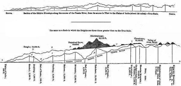
Other phenomena of no less importance than the distribution of vapour, and more or less depending on it, are the duration and amount of solar and terrestrial radiation. Towards D the sun is rarely seen during the rainy season, as well from the constant presence of nimbi aloft, as from fog on the surface of the ground. An absence of both light and heat is the result south of the parallel of Kinchin; and at C low fogs prevail at the same season, but do not intercept either the same amount of light or heat; whilst at T there is much sunshine and bright light. During the night, again, there is no terrestrial radiation between S and P; the rain either continues to pour—in some months with increased violence—or the saturated atmosphere is condensed into a thick white mist, which hangs over the redundant vegetation. A bright starlight night is almost unknown in the summer months at 6000 to 10,000 feet, but is frequent in December and January, and at intervals between October and May, when, however, vegetation is little affected by the cold of nocturnal radiation. In the regions north of Kinchin, starlight nights are more frequent, and the cold produced by radiation, at 14,000 feet, is often severe towards the end of the rains in September. Still the amount of clear weather during the night is small; the fog clears off for an hour or two at sunset as the wind falls, but the returning cold north current again chills the air soon afterwards, and rolling masses of vapour are hence flying overhead, or sweeping the surface of the earth, throughout the summer nights. In the Tibetan regions, on the other hand, bright nights and even sharp frosts prevail throughout the warmest months.
Referring again to the cut, it must be borne in mind that neither of the two meridional ridges runs in a straight line, but that they wind or zigzag as all mountain ranges do; that spurs from each ridge are given off from either flank alternately, and that the origin of a spur on one side answers to the source of a river (i.e., the head of a valley) on the other. These rivers are feeders of the main stream, the Teesta, and run at more or less of an angle to the latter. The spurs from the east flank of one ridge cross, at their ends, those from the west flank of another; and thus transverse valleys are formed, presenting many modifications of climate with regard to exposure, temperature, and humidity.
The roads from the plains of India to the watershed in Tibet always cross these lateral spurs. The main ridge is too winding and rugged, and too lofty for habitation throughout the greater part of its length, while the river-channel is always very winding, unhealthy for the greater part of the year below 4000 feet, and often narrow, gorge-like, and rocky. The villages are always placed above the unhealthy regions, on the lateral spurs, which the traveller repeatedly crosses throughout every day’s march; for these spurs give off lesser ones, and these again others of a third degree, whence the country is cut up into as many spurs, ridges, and ranges, as there are rills, streams, and rivers amongst the mountains.
Though the direction of the main atmospheric current is to the north, it is in reality seldom felt to be so, except the observer be on the very exposed mountain tops, or watch the motions of the upper strata of atmosphere. Lower currents of air rush up both the main and lateral valleys, throughout the day; and from the sinuosities in the beds of the rivers, and the generally transverse directions of their feeders, the current often becomes an east or west one. In the branch valleys draining to the north the wind still ascends; it is, in short, an ascending warm, moist current, whatever course be pursued by the valleys it follows.
The sides of each valley are hence equally supplied with moisture, though local circumstances render the soil on one or the other flank more or less humid and favourable to a luxuriant vegetation: such differences are a drier soil on the north side, with a too free exposure to the sun at low elevations, where its rays, however transient, rapidly dry the ground, and where the rains, though very heavy, are of shorter duration, and where, owing to the capacity of the heated air for retaining moisture, day fogs are comparatively rare. In the northern parts of Sikkim, again, some of the lateral valleys are so placed that the moist wind strikes the side facing the south, and keeps it very humid, whilst the returning cold current from the neighbouring Tibetan mountains impinges against the side facing the north, which is hence more bare of vegetation. An infinite number of local peculiarities will suggest themselves to any one conversant with physical geography, as causing unequal local distribution of light, heat, and moisture in the different valleys of so irregular a country; namely, the amount of slope, and its power of retaining moisture and soil; the composition and hardness of the rocks; their dip and strike; the protection of some valleys by lofty snowed ridges; and the free southern exposures of others at great elevations.
The position and elevation of the perpetual snow[401] vary with those of the individual ranges, and their exposure to the south wind. The expression that the perpetual snow lies lower and deeper on the southern slopes of the Himalayan mountains than on the northern, conveys a false impression. It is better to say that the snow lies deeper and lower on the southern faces of the individual mountains and spurs that form the snowy Himalaya. The axis itself of the chain is generally far north of the position of the spurs that catch all the snow, and has comparatively very little snow on it, most of what there is lying upon north exposures.
A reference to the woodcut will show that the same circumstances which affect the distribution of moisture and vegetation, determine the position, amount, and duration of the snow. The principal fall will occur, as before shown, where the meridional range first attains a sufficiently great elevation, and the air becomes consequently cooled below 32°; this is at a little above 14,000 feet, sporadic falls occurring even in summer at that elevation: these, however, melt immediately, and the copious winter falls also are dissipated before June. As the depth of rain-fall diminishes in advancing north to the higher parts of the meridional ranges, so does that of the snow-fall. The permanence of the snow, again, depends on—1. The depth of the accumulation; 2. The mean temperature of the spot; 3. The melting power of the sun’s rays; 4. The prevalence and strength of evaporating winds. Now at 14,000 feet, though the accumulation is immense, the amount melted by the sun’s rays is trifling, and there are no evaporating winds; but the mean temperature is so high, and the corroding powers of the rain (which falls abundantly throughout summer) and of the warm and humid ascending currents are so great, that the snow is not perennial. At 15,500 feet, again, it becomes perennial, and its permanence at this low elevation (at P) is much favoured by the accumulation and detention of fogs over the rank vegetation which prevails from S nearly to P; and by the lofty mountains beyond it, which shield it from the returning dry currents from the north. In proceeding north all the circumstances that tend to the dispersion of the snow increase, whilst the fall diminishes. At P the deposition is enormous and the snow-line low—16,000 feet; whilst at T little falls, and the limit of perpetual snow is 19,000 and 20,000 feet. Hence the anomaly, that the snow-line ascends in advancing north to the coldest Himalayan regions. The position of the greatest peaks and of the greatest mass of perpetual snow being generally assumed as indicating a ridge and watershed, travellers, arguing from single mountains alone, on the meridional ridges, have at one time supported and at another denied the assertion, that the snow lies longer and deeper on the north than on the south slope of the Himalayan ridge.
The great accumulation of snow at 15,000 feet, in the parallel of P, exercises a decided influence on the vegetation. The alpine rhododendrons hardly reach 14,000 feet in the broad valleys and round-headed spurs of the mountains of the Tunkra and Chola passes; whilst the same species ascend to 16,000, and one to 17,000 feet, at T. Beyond the latter point, again, the great aridity of the climate prevents their growth, and in Tibet there are generally none even as low as 12,000 and 14,000 feet. Glaciers, again, descend to 15,000 feet in the tortuous gorges which immediately debouch from the snows of Kinchinjunga, but no plants grow on the débris they carry down, nor is there any sward of grass or herbage at their base, the atmosphere immediately around being chilled by enormous accumulations of snow, and the summer sun rarely warming the soil. At T, again, the glaciers do not descend below 16,000 feet, but a greensward of vegetation creeps up to their bases, dwarf rhododendrons cover the moraines, and herbs grow on the patches of earth carried down by the latter, which are thawed by the more frequent sunshine, and by the radiation of heat from the unsnowed flanks of the valleys down which these ice-streams pour.
Looking eastward or westward on the map of India, we perceive that the phenomenon of perpetual snow is regulated by the same laws. From the longitude of Upper Assam in 95° E to that of Kashmir in 75° E, the lowest limit of perpetual snow is 15,500 to 16,000 feet, and a shrubby vegetation affects the most humid localities near it, at 12,000 to 14,000 feet. Receding from the plains of India and penetrating the mountains, the climate becomes drier, the snowline rises, and vegetation diminishes, whether the elevation of the land increases or decreases; plants reaching 17,000 and 18,000 feet, and the snow-line, 20,000 feet. To mention extreme cases; the snow-level of Sikkim in 27° 30 minutes is at 16,000 feet, whereas in latitude 35° 30 minutes Dr. Thomson found the snow line 20,000 feet on the mountains near the Karakoram Pass, and vegetation up to 18,500 feet—features I found to be common also to Sikkim in latitude 28°.
The Himalaya, north of Nepal, and thence eastward to the bend of the Yaru-Tsampu (or Tibetan Burrampooter) has for its geographical limits the plains of India to the south, and the bed of the Yaru to the north. All between these limits is a mountain mass, to which Tibet (though so often erroneously called a plain)[402] forms no exception. The waters from the north side of this chain flow into the Tsampu, and those from the south side into the Burrampooter of Assam, and the Ganges. The line, however tortuous, dividing the heads of these waters, is the watershed, and the only guide we have to the axis of the Himalaya. This has never been crossed by Europeans, except by Captain Turner’s embassy in 1798, and Captain Bogle’s in 1779, both of which reached the Yaru river. In the account published by Captain Turner, the summit of the watershed is not rigorously defined, and the boundary, of Tibet and Bhotan is sometimes erroneously taken for it; the boundary being at that point a southern spur of Chumulari.[403] Eastwards from the sources of the Tsampu, the watershed of the Himalaya seems to follow a very winding course, and to be everywhere to the north of the snowy peaks seen from the plains of India. It is by a line through these snowy peaks that the axis of the Himalaya is represented in all our maps; because they seem from the plains to be situated on an east and west ridge, instead of being placed on subsidiary meridional ridges, as explained above. It is also across or along the subsidiary ridges that the boundary line between the Tibetan provinces and those of Nepal, Sikkim, and Bhotan, is usually drawn; because the enormous accumulations of snow form a more efficient natural barrier than the greater height of the less snowed central part of the chain beyond them.
Though, however, our maps draw the axis through the snowy peaks, they also make the rivers to rise beyond the latter, on the northern slopes as it were, and to flow southwards through gaps in the axis. Such a feature is only reconcilable with the hypothesis of the chain being double, as the Cordillera of Peru and Chili is said to be, geographically, and which in a geological sense it no doubt is: but to the Cordillera the Himalaya offers no parallel. The results of Dr. Thomson’s study of the north-west Himalaya and Tibet, and my own of the north-east extreme of Sikkim and Tibet, first gave me an insight into the true structure of this chain. Donkia mountain is the culminant point of an immensely elevated mass of mountains, of greater mean height than a similarly extensive area around Kinchin junga. It comprises Chumulari, and many other mountains much above 20,000 feet, though none equalling Kinchinjunga, Junnoo, and Kubra. The great lakes of Ramchoo and Cholamoo are placed on it; and the rivers rising on it flow in various directions; the Painomchoo north-west into the Yaru; the Arun west to Nepal; the Teesta south-west through Sikkim; the Machoo south, and the Pachoo south-east, through Bhotan. All these rivers have their sources far beyond the great snowed mountains, the Arun most conspicuously of all, flowing completely at the back or north of Kinchinjunga. Those that flow southwards, break through no chain, nor do they meet any contraction as they pass the snowy parts of the mountains which bound the valleys in which they flow, but are bound by uniform ranges of lofty mountains, which become more snowy as they approach the plains of India. These valleys, however, gradually contract as they descend, being less open in Sikkim and Nepal than in Tibet, though there bounded by rugged mountains, which from being so bare of snow and of vegetation, do not give the same impression of height as the isolated sharper peaks which rise out of a dense forest, and on which the snow limit is 4000 or 5000 feet lower.
The fact of the bottom of the river valleys being flatter towards the watershed, is connected with that of their fall being less rapid at that part of their course; this is the consequence of the great extent in breadth of the most elevated portion of the chain. If we select the Teesta as an example, and measure its fall at three points of its course, we shall find the results very different. From its principal source at Lake Cholamoo, it descends from 17,000 to 15,000 feet, with a fall of 60 feet to the mile; from 15,000 to 12,000 feet, the fall is 140 feet to the mile; in the third part of its course it descends from 12,000 to 5000 feet, with a fall of 160 feet to the mile; and in the lower part the descent is from 5000 feet to the plains of India at 300 feet, giving a fall of 50 feet to the mile. There is, however, no marked limit to these divisions; its valley. gradually contracts, and its course gradually becomes more rapid. It is worthy of notice that the fall is at its maximum through that part of its valley of which the flanks are the most loaded with snow; where the old moraines are very conspicuous, and where the present accumulations from landslips, etc., are the most extensive.[404]
With reference to Kinchinjunga, these facts are of importance, as showing that mere elevation is in physical geography of secondary importance. That lofty mountain rises from a spur of the great range of Donkia, and is quite removed from the watershed or axis of the Himalaya, the rivers which drain its northern and southern flanks alike flowing to the Ganges. Were the Himalaya to be depressed 18,000 feet, Kubra, Junnoo, Pundim, etc., would form a small cluster of rocky islands 1000 to 7000 feet high, grouped near Kinchinjunga, itself a cape 10,000 feet high, which would be connected by a low, marrow neck, with an extensive and mountainous tract of land to its north-east; the latter being represented by Donkia. To the north of Kinchin a deep bay or inlet would occupy the present valley of the Arun, and would be bounded on the north by the axis of the Himalaya, which would form a continuous tract of land beyond it. Since writing the above, I have seen Professor J. Forbes’s beautiful work on the glaciers of Norway: it fully justifies a comparison of the Himalaya to Norway, which has long been a familiar subject of theoretical enquiry with Dr. Thomson and myself. The deep narrow valleys of Sikkim admirably represent the Norwegian fiords; the lofty, rugged, snowy mountains, those more or less submerged islands of the Norwegian coast; the broad rearward watershed, or axis of the chain, with its lakes, is the same in both, and the Yaru-tsampu occupies the relative position of the Baltic.
Along the whole chain of the Himalaya east of Kumaon there are, I have no doubt, a succession of such lofty masses as Donkia, giving off stupendous spurs such as that on which Kinchin forms so conspicuous a feature. In support of this view we find every river rising far beyond the snowy peaks, which are separated by continuously unsnowed ranges placed between the great white masses that these spurs present to the observer from the south.[405] From the Khasia mountains (south-east of Sikkim) many of these groups or spurs were seen by Dr. Thomson and myself, at various distances (80 to 210 miles); and these groups were between the courses of the great rivers the Soobansiri, Monass, and Pachoo, all east of Sikkim. Other masses seen from the Gangetic valley probably thus mark the relative positions of the Arun, Cosi, Gunduk, and Gogra rivers.
Another mass like that of Chumulari and Donkia, is that around the Mansarowar lakes, so ably surveyed by the brothers Captains R. and H. Strachey, which is evidently the centre of the Himalaya. From it the Gogra, Sutlej, Indus, and Yaru rivers all flow to the Indian side of Asia; and from it spring four chains, two of which are better known than the others. These are:—1. The eastern Himalaya, whose axis runs north of Nepal, Sikkim, and Bhotan, to the bend of the Yaru, the valley of which it divides from the plains of India. 2. The north-west Himalaya, which separates the valley of the Indus from the plains of India. Behind these, and probably parallel to them, lie two other chains. 3. The Kouenlun or Karakoram chain, dividing the Indus from the Yarkand river. 4. The chain north of the Yaru, of which nothing is known. All the waters from the two first of these chains, flow into the Indian Ocean, as do those from the south faces of the third and fourth; those from the north side of the Kouenlun, and of the chain north of the Yaru, flow into the great valley of Lake Lhop, which may once have been continuous with the Amoor river.[406]
For this view of the physical geography of the western Himalaya and central Asia, I am indebted to Dr. Thomson. It is more consonant with nature, and with what we know of the geography of the country and of the nature of mountain chains, than that of the illustrious Humboldt, who divides central Asia by four parallel chains, united by two meridional ones; one at each extremity of the mountain district. It follows in continuation and conclusion of our view that the mountain mass of Pamir or Bolor, between the sources of the Oxus and those of the Yarkand river, may be regarded as a centre from which spring the three greatest mountain systems of Asia. These are:—1. A great chain, which runs in a north-easterly direction as far as Behring’s Straits, separating all the rivers of Siberia from those which flow into the Pacific Ocean. 2. The Hindoo Koosh, continued through Persia, and Armenia into Taurus. And, 3. The Muztagh or Karakorum, which probably extends due east into China, south of the Hoang-ho, but which is broken up north of Mansarowar into the chains which have been already enumerated.
F. ON THE CLIMATE OF SIKKIM.
The meteorology of Sikkim, as of every part of the Himalayan range, is a subject of growing interest and importance; as it becomes yearly more necessary for the Government to afford increased facilities for a residence in the mountains to Europeans in search of health, or of a salubrious climate for their families, or for themselves on retirement from the exhausting service of the plains. I was therefore surprised to find no further register of the weather at Dorjiling, than an insufficient one of the rain-fall, kept by the medical officer in charge of the station; who, in this, as in all similar cases,[407] has neither the time nor the opportunity to give even the minimum of required attention to the subject of meteorology. This defect has been in a measure remedied by Dr. Chapman, who kept a twelve-months’ register in 1837, with instruments carefully compared with Calcutta standards by the late James Prinsep, Esq., one of the most accomplished men in literature and science that India ever saw.
The annual means of temperature, rain-fall, etc., vary greatly in the Himalaya; and apparently slight local causes produce such great differences of temperature and humidity, that one year’s observations taken at one spot, however full and accurate they may be, are insufficient: this is remarkably the case in Sikkim, where the rainfall is great, and where the difference between those of two consecutive years is often greater than the whole annual London fall. My own meteorological observations necessarily form but a broken series, but they were made with the best instruments, and with a view to obtaining results that should be comparable inter se, and with those of Calcutta; when away from Dorjiling too, in the interior of Sikkim, I had the advantage of Mr. Muller’s services in taking observations at hours agreed upon previous to my leaving, and these were of the greatest importance, both for calculating elevations, and for ascertaining the differences of temperature, humidity, diurnal atmospheric tide, and rain-fall; all of which vary with the elevation, and the distance from the plains of India.
Mr. Hodgson’s house proved a most favourable spot for an observatory, being placed on the top of the Dorjiling spur, with its broad verandah facing the north, in which I protected the instruments from radiation[408] and wind. Broad grass-plots and a gravel walk surrounded the house, and large trees were scattered about; on three sides the ground sloped away, while to the north the spur gently rose behind.
Throughout the greater part of the year the prevailing wind is from the south-east, and comes laden with moisture from the Bay of Bengal: it rises at sunrise, and its vapours are early condensed on the forests of Sinchul; billowy clouds rapidly succeed small patches of vapour, which rolling over to the north side of the mountain, are carried north-west, over a broad intervening valley, to Dorjiling. There they bank on the east side of the spur, and this being partially clear of wood, the accumulation is slow, and always first upon the clumps of trees. Very generally by 9 a.m., the whole eastern sky, from the top of Dorjiling ridge, is enveloped in a dense fog, while the whole western exposure enjoys sunshine for an hour or two later. At 7 or 8 a.m., very small patches are seen to collect on Tonglo, which gradually dilate and coalesce, but do not shroud the mountain for some hours, generally not before 11 a.m. or noon. Before that time, however, masses of mist have been rolling over Dorjiling ridge to the westward, and gradually filling up the valleys, so that by noon, or 1 p.m., every object is in cloud. Towards sunset it falls calm, when the mist rises, first from Sinchul, or if a south-east wind sets in, from Tonglo first.
The temperature is more uniform at Mr. Hodgson’s bungalow, which is on the top of the Dorjiling ridge, than on either of its flanks; this is very much because a good deal of wood is left upon it, whose cool foliage attracts and condenses the mists. Its mean temperature is lower by nearly 2·5° than that of Mr. Muller’s and Dr. Campbell’s houses, both situated on the slopes, 400 feet below. This I ascertained by numerous comparative observations of the temperature of the air, and by burying thermometers in the earth: it is chiefly to be accounted for by the more frequent sunshine at the lower stations, the power of the sun often raising the thermometer in shade to 80°, at Mr. Muller’s; whereas during the summer I spent at Mr. Hodgson’s it never rose much above 70°, attaining that height very seldom and for a very short period only. The nights, again, are uniformly and equally cloudy at both stations, so that there is no corresponding cold of nocturnal radiation to reduce the temperature.
The mean decrease of temperature due to elevation, I have stated (Appendix I.) to be about 1° for every 300 feet of ascent; according to which law Mr. Hodgson’s should not be more than 1·5° colder than Mr. Muller’s. These facts prove how difficult it is to choose unexceptionable sites for meteorological observatories in mountainous countries; discrepancies of so great an amount being due to local causes, which, as in this case, are perhaps transient; for should the top of the spur be wholly cleared of timber, its temperature would be materially raised; at the expense, probably, of a deficiency of water at certain seasons. Great inequalities of temperature are also produced by ascending currents of heated air from the Great Rungeet valley, which affect certain parts of the station only; and these raise the thermometer 10° (even when the sun is clouded) above what it indicates at other places of equal elevation.
The mean temperature of Dorjiling (elev. 7,430 feet) is very nearly 50°, or 2° higher than that of London, and 26° below that of Calcutta (78°,[409] or 78·5° in the latest published tables[410]); which, allowing 1° of diminution of temperature for every degree of latitude leaves 1° due to every 300 feet of ascent above Calcutta to the height of Dorjiling, agreeably to my own observations. This diminution is not the same for greater heights, as I shall have occasion to show in a separate chapter of this Appendix, on the decrement of heat with elevation.
A remarkable uniformity of temperature prevails throughout the year at Dorjiling, there being only 22° difference between the mean temperatures of the hottest and coldest months; whilst in London, with a lower mean temperature, the equivalent difference is 27°. At 11,000 feet this difference is equal to that of London. In more elevated regions, it is still greater, the climate becoming excessive at 15,000 feet, where the difference amounts to 30° at least.[411] The accompanying table is the result of an attempt to approximate to the mean temperatures and ranges of the thermometer at various elevations.
Altitude Mean Shade Mean Warmest Month Mean Coldest Month Mean Daily Range of Temperature Rain-fall in inches
11,000 feet 15,000 feet 19,000 feet 40·9 29·8 19·8 50·0 40·0 32·0 24·0 11·0 0·0 20·0 27·0 35·0 40·0 20·0 10·0 1°=320 feet 1°=350 feet 1°=400 feet
Supposing the same formula to apply (which I exceedingly doubt) to heights above 19,000 feet, 2° would be the mean annual temperature of the summit of Kinchinjunga, altitude 28,178 feet, the loftiest known spot on the globe: this is a degree or two higher than the temperature of the poles of greatest cold on the earth’s surface, and about the temperature of Spitzbergen and Melville island.
The upper limit of phenogamic vegetation coincides with a mean temperature of 30° on the south flank of Kinchinjunga, and of 22° in Tibet; in both cases annuals and perennial-rooted herbaceous plants are to be found at elevations corresponding to these mean temperatures, and often at higher elevations in sheltered localities. I have assumed the decrease of temperature for a corresponding amount of elevation to be gradually less in ascending (1°=320 feet at 6000 to 10,000 feet, 1°=400 feet at 14,000 to 18,000 feet). My observations appear to prove this, but I do not regard them as conclusive; supposing them to be so, I attribute it to a combination of various causes, especially to the increased elevation and yet unsnowed condition of the mass of land elevated above 16,000 feet, and consequent radiation of heat; also to the greater amount of sunshine there; and to the less dense mists which obstruct the sun’s rays at all elevations. In corroboration of this I may mention that the decrease of temperature with elevation is much less in summer than in winter, 1° of Fahr. being equivalent to only 250 feet in January between 7000 and 13,000 feet, and to upwards of 400 feet in July. Again, at Dorjiling (7,430 feet) the temperature hardly ever rises above 70° in the summer months, yet it often rises even higher in Tibet at 12,000 to 14,000 feet. On the other hand, the winters, and the winter nights especially, are disproportionately cold at great heights, the thermometer falling upwards of 40° below the Dorjiling temperature at an elevation only 6000 feet higher.
The diurnal distribution of temperature is equally and similarly affected by the presence of vapour at different altitudes. The lower and outer ranges of 6000 to 10,000 feet, first receive the diurnal charge of vapour-loaded southerly winds; those beyond them get more of the sun’s rays, and the rearward ones more still. Though the summer days of the northern localities are warmer than their elevation would indicate, the nights are not proportionally cold; for the light mist of 14,000 feet, which replaces the dense fog of 7000 feet, effectually obstructs nocturnal radiation, though it is less an obstacle to solar radiation. Clear nights, be it observed, are as rare at Momay (15,300 feet) as at Dorjiling, the nights if windy being rainy; or, if calm, cold currents descend from the mountains, condensing the moist vapours of the valleys, whose narrow floors are at sunrise bathed in mist at all elevations in Sikkim. The rise and dispersion of these dense mists, and their collection and recondensation on the mountains in the morning, is one of the most magnificent phenomena of the Himalaya, when viewed from a proper elevation; it commences as soon as the sun appears on the horizon.
The mean daily range of the thermometer at 7000 feet is 13° in cleared spots, but considerably less in wooded, and certainly one-third less in the forest itself. At Calcutta, which has almost an insular climate, it amounts to 17°; at Delhi, which has a continental one, to 24·6°; and in London to 17·5°. At 11,000 feet it amounts to about 20°, and at 15,000 feet to 27°. These values vary widely in the different months, being much less in the summer or rainy months. The following is probably a fair approximation:—
At 7,000 feet it amounts to 8–9° in Aug. and Sept., and 17° in Dec. At 11,000 feet it amounts to 12° in Aug. and Sept., and 30° in Dec. At 15,000 feet it amounts to 15° in Aug. and Sept., and 40° in Dec. At London it amounts to 20° in Aug. and Sept., and 10° in Dec.
The distribution of temperature throughout the day and year varies less at Dorjiling than in most mountainous countries, owing to the prevailing moisture, the effect of which is analogous to that of a circumambient ocean to an island: the difference being, that in the case of the island the bulk of water maintains an uniform temperature; in that of Dorjiling the quantity of vapour acts directly by interfering with terrestrial and solar-radiation, and indirectly by nurturing a luxuriant vegetation. The result in the latter case is a climate remarkable for its equability, and similar in many features to that of New Zealand, South-west Chili, Fuegia, and the damp west coasts of Scotland and Ireland, and other countries exposed to moist sea winds.
The mean temperature of the year at Dorjiling, as taken by maxima and minima thermometers[412] by Dr. Chapman, is nearly the same as that of March and October: January, the coldest month, is more than 13·4° colder than the mean of the year; but the hottest month is only 8·3° warmer than the same mean: at Calcutta the months vary less from the mean; at Delhi more; and in London the distribution is wholly different; there being no rains to modify the summer heat, July is 13° hotter, and January 14° colder than the mean of the year.