VOLUME XVI SLICE VIII Logarithm to Lord Advocate (continued 7)
Reading edition
For a full account of the Lombard League see C. Vignati, Storia diplomata della Lega Lombarda (Milan, 1866); H. Prutz, Kaiser Friedrich I., Band ii. (Danzig, 1871-1874); W. von Giesebrecht, Geschichte der deutschen Kaiserzeit, Band v. (Leipzig, 1888); and J. Ficker, Zur Geschichte des Lombardenbundes (Vienna, 1868).

LOMBARDO, the name of a family of Venetian sculptors and architects; their surname was apparently Solaro, and the name of Lombardo was given to the earliest known, Martino, who emigrated from Lombardy to Venice in the middle of the 15th century and became celebrated as an architect. He had two sons, Moro and Pietro, of whom the latter (c. 1435-1515) was one of the greatest sculptors and architects of his time, while his sons Antonio (d. 1516) and Tullio (d. 1559) were hardly less celebrated. Pietro’s work as an architect is seen in numerous churches, the Vendramini-Calargi palace (1481), the doge’s palace (1498), the façade (1485) of the scuola of St Mark and the cathedral of Cividale del Friuli (1502); but he is now more famous as a sculptor, often in collaboration with his sons; he executed the tomb of the doge Mocenigo (1478) in the church of San Giovanni e Paolo at Venice, and a bas-relief for the tomb of Dante at Ravenna, and in 1483 began the beautiful decorations in the church of Sta Maria de’ Miracoli at Venice, which is associated with his workshop (see also Venice for numerous references to the work of the Lombardi). Antonio’s masterpiece is the marble relief of St Anthony making a new-born child speak in defence of its mother’s honour, in the Santo at Padua (1505). Tullio’s best-known works are the four kneeling angels (1484) in the church of San Martino, Venice, a coronation of the Virgin in San Giovanni Crisostomo and two bas-reliefs in the Santo, Padua, besides two others formerly in the Spitzer collection, representing Vulcan’s Forge and Minerva disputing with Neptune.
LOMBARDS, or Langobardi, a Suevic people who appear to have inhabited the lower basin of the Elbe and whose name is believed to survive in the modern Bardengau to the south of Hamburg. They are first mentioned in connexion with the year A.D. 5, at which time they were defeated by the Romans under Tiberius, afterwards emperor. In A.D. 9, however, after the destruction of Varus’s army, the Romans gave up their attempt to extend their frontier to the Elbe. At first, with most of the Suevic tribes, they were subject to the hegemony of Maroboduus, king of the Marcomanni, but they revolted from him in his war with Arminius, chief of the Cherusci, in the year 17. We again hear of their interference in the dynastic strife of the Cherusci some time after the year 47. From this time they are not mentioned until the year 165, when a force of Langobardi, in alliance with the Marcomanni, was defeated by the Romans, apparently on the Danubian frontier. It has been inferred from this incident that the Langobardi had already moved southwards, but the force mentioned may very well have been sent from the old home of the tribe, as the various Suevic peoples seem generally to have preserved some form of political union. From this time onwards we hear no more of them until the end of the 5th century.
In their own traditions we are told that the Langobardi were originally called Winnili and dwelt in an island named Scadinavia (with this story compare that of the Gothic migration, see Goths). Thence they set out under the leadership of Ibor and Aio, the sons of a prophetess called Gambara, and came into conflict with the Vandals. The leaders of the latter prayed to Wodan for victory, while Gambara and her sons invoked Frea. Wodan promised to give victory to those whom he should see in front of him at sunrise. Frea directed the Winnili to bring their women with their hair let down round their faces like beards and turned Wodan’s couch round so that he faced them. When Wodan awoke at sunrise he saw the host of the Winnili and said, “Qui sunt isti Longibarbi?”—“Who are these long-beards?”—and Frea replied, “As thou hast given them the name, give them also the victory.” They conquered in the battle and were thenceforth known as Langobardi. After this they are said to have wandered through regions which cannot now be identified, apparently between the Elbe and the Oder, under legendary kings, the first of whom was Agilmund, the son of Aio.
Shortly before the end of the 5th century the Langobardi appear to have taken possession of the territories formerly occupied by the Rugii whom Odoacer had overthrown in 487, a region which probably included the present province of Lower Austria. At this time they were subject to Rodulf, king of the Heruli, who, however, took up arms against them; according to one story, owing to the treacherous murder of Rodulf’s brother, according to another through an irresistible desire for fighting on the part of his men. The result was the total defeat of the Heruli by the Langobardi under their king Tato and the death of Rodulf at some date between 493 and 508. By this time the Langobardi are said to have adopted Christianity in its Arian form. Tato was subsequently killed by his nephew Waccho. The latter reigned for thirty years, though frequent attempts were made by Ildichis, a son or grandson of Tato, to recover the throne. Waccho is said to have conquered the Suabi, possibly the Bavarians, and he was also involved in strife with the Gepidae, with whom Ildichis had taken refuge. He was succeeded by his youthful son Walthari, who reigned only seven years under the guardianship of a certain Audoin. On Walthari’s death (about 546?) Audoin succeeded. He also was involved in hostilities with the Gepidae, whose support of Ildichis he repaid by protecting Ustrogotthus, a rival of their king Thorisind. In these quarrels both nations aimed at obtaining the support of the emperor Justinian, who, in pursuance of his policy of playing off one against the other, invited the Langobardi into Noricum and Pannonia, where they now settled.
A large force of Lombards under Audoin fought on the imperial side at the battle of the Apennines against the Ostrogothic king Totila in 553, but the assistance of Justinian, though often promised, had no effect on the relations of the two nations, which were settled for the moment after a series of truces by the victory of the Langobardi, probably in 554. The resulting peace was sealed by the murder of Ildichis and Ustrogotthus, and the Langobardi seem to have continued inactive until the death of Audoin, perhaps in 565, and the accession of his son Alboin, who had won a great reputation in the wars with the Gepidae. It was about this time that the Avars, under their first Chagun Baian, entered Europe, and with them, Alboin is said to have made an alliance against the Gepidae under their new king Cunimund. The Avars, however, did not take part in the final battle, in which the Langobardi were completely victorious. Alboin, who had slain Cunimund in the battle, now took Rosamund, daughter of the dead king, to be his wife.
In 568 Alboin and the Langobardi, in accordance with a compact made with Baian, which is recorded by Menander, abandoned their old homes to the Avars and passed southwards into Italy, were they were destined to found a new and mighty kingdom.
(F. G. M. B.)
The Lombard Kingdom in Italy.—In 568 Alboin, king of the Langobards, with the women and children of the tribe and all their possessions, with Saxon allies, with the subject tribe of the Gepidae and a mixed host of other barbarians, descended into Italy by the great plain at the head of the Adriatic. The war which had ended in the downfall of the Goths had exhausted Italy; it was followed by famine and pestilence; and the government at Constantinople made but faint efforts to retain the province which Belisarius and Narses had recovered for it. Except in a few fortified places, such as Ticinum or Pavia, the Italians did not venture to encounter the new invaders; and, though Alboin was not without generosity, the Lombards, wherever resisted, justified the opinion of their ferocity by the savage cruelty of the invasion. In 572, according to the Lombard chronicler, Alboin fell a victim to the revenge of his wife Rosamund, the daughter of the king of the Gepidae, whose skull Alboin had turned into a drinking cup, out of which he forced Rosamund to drink. By this time the Langobards had established themselves in the north of Italy. Chiefs were placed, or placed themselves, first in the border cities, like Friuli and Trent, which commanded the north-eastern passes, and then in other principal places; and this arrangement became characteristic of the Lombard settlement. The principal seat of the settlement was the rich plain watered by the Po and its affluents, which was in future to receive its name from them; but their power extended across the Apennines into Liguria and Tuscany, and then southwards to the outlying dukedoms of Spoleto and Benevento. The invaders failed to secure any maritime ports or any territory that was conveniently commanded from the sea. Ticinum (Pavia), the one place which had obstinately resisted Alboin, became the seat of their kings.
After the short and cruel reign of Cleph, the successor of Alboin, the Lombards (as we may begin for convenience sake to call them) tried for ten years the experiment of a national confederacy of their dukes (as, after the Latin writers, their chiefs are styled), without any king. It was the rule of some thirty-five or thirty-six petty tyrants, under whose oppression and private wars even the invaders suffered. With anarchy among themselves and so precarious a hold on the country, hated by the Italian population and by the Catholic clergy, threatened also by an alliance of the Greek empire with their persistent rivals the Franks beyond the Alps, they resolved to sacrifice their independence and elect a king. In 584 they chose Authari, the grandson of Alboin, and endowed the royal domain with a half of their possessions. From this time till the fall of the Lombard power before the arms of their rivals the Franks under Charles the Great, the kingly rule continued. Authari, “the Long-haired,” with his Roman title of Flavius, marks the change from the war king of an invading host to the permanent representative of the unity and law of the nation, and the increased power of the crown, by the possession of a great domain, to enforce its will. The independence of the dukes was surrendered to the king. The dukedoms in the neighbourhood of the seat of power were gradually absorbed, and their holders transformed into royal officers. Those of the northern marches, Trent and Friuli, with the important dukedom of Turin, retained longer the kind of independence which marchlands usually give where invasion is to be feared. The great dukedom of Benevento in the south, with its neighbour Spoleto, threatened at one time to be a separate principality, and even to the last resisted, with varying success, the full claims of the royal authority at Pavia.
The kingdom of the Lombards lasted more than two hundred years, from Alboin (568) to the fall of Desiderius (774)—much longer than the preceding Teutonic kingdom of Theodoric and the Goths. But it differed from the other Teutonic conquests in Gaul, in Britain, in Spain. It was never complete in point of territory: there were always two, and almost to the last three, capitals—the Lombard one, Pavia; the Latin one, Rome; the Greek one, Ravenna; and the Lombards never could get access to the sea. And it never was complete over the subject race: it profoundly affected the Italians of the north; in its turn it was entirely transformed by contact with them; but the Lombards never amalgamated with the Italians till their power as a ruling race was crushed by the victory given to the Roman element by the restored empire of the Franks. The Langobards, German in their faults and in their strength, but coarser, at least at first, than the Germans whom the Italians had known, the Goths of Theodoric and Totila, found themselves continually in the presence of a subject population very different from anything which the other Teutonic conquerors met with among the provincials—like them, exhausted, dispirited, unwarlike, but with the remains and memory of a great civilization round them, intelligent, subtle, sensitive, feeling themselves infinitely superior in experience and knowledge to the rough barbarians whom they could not fight, and capable of hatred such as only cultivated races can nourish. The Lombards who, after they had occupied the lands and cities of Upper Italy, still went on sending forth furious bands to plunder and destroy where they did not care to stay, never were able to overcome the mingled fear and scorn and loathing of the Italians. They adapted themselves very quickly indeed to many Italian fashions. Within thirty years of the invasions, Authari took the imperial title of Flavius, even while his bands were leading Italian captives in leash like dogs under the walls of Rome, and under the eyes of Pope Gregory; and it was retained by his successors. They soon became Catholics; and then in all the usages of religion, in church building, in founding monasteries, in their veneration for relics, they vied with Italians. Authari’s queen, Theodelinda, solemnly placed the Lombard nation under the patronage of St John the Baptist, and at Monza she built in his honour the first Lombard church, and the royal palace near it. King Liutprand (712-744) bought the relics of St Augustine for a large sum to be placed in his church at Pavia. Their Teutonic speech disappeared; except in names and a few technical words all traces of it are lost. But to the last they had the unpardonable crime of being a ruling barbarian race or caste in Italy. To the end they are “nefandissimi,” execrable, loathsome, filthy. So wrote Gregory the Great when they first appeared. So wrote Pope Stephen IV., at the end of their rule, when stirring up the kings of the Franks to destroy them.
Authari’s short reign (584-591) was one of renewed effort for conquest. It brought the Langobards face to face, not merely with the emperors at Constantinople, but with the first of the great statesmen popes, Gregory the Great (590-604). But Lombard conquest was bungling and wasteful; when they had spoiled a city they proceeded to tear down its walls and raze it to the ground. Authari’s chief connexion with the fortunes of his people was an important, though an accidental one. The Lombard chronicler tells a romantic tale of the way in which Authari sought his bride from Garibald, duke of the Bavarians, how he went incognito in the embassy to judge of her attractions, and how she recognized her disguised suitor. The bride was the Christian Theodelinda, and she became to the Langobards what Bertha was to the Anglo-Saxons and Clotilda to the Franks. She became the mediator between the Lombards and the Catholic Church. Authari, who had brought her to Italy, died shortly after his marriage. But Theodelinda had so won on the Lombard chiefs that they bid her as queen choose the one among them whom she would have for her husband and for king. She chose Agilulf, duke of Turin (592-615). He was not a true Langobard, but a Thuringian. It was the beginning of peace between the Lombards and the Catholic clergy. Agilulf could not abandon his traditional Arianism, and he was a very uneasy neighbour, not only to the Greek exarch, but to Rome itself. But he was favourably disposed both to peace and to the Catholic Church. Gregory interfered to prevent a national conspiracy against the Langobards, like that of St Brice’s day in England against the Danes, or that later uprising against the French, the Sicilian Vespers. He was right both in point of humanity and of policy. The Arian and Catholic bishops went on for a time side by side; but the Lombard kings and clergy rapidly yielded to the religious influences around them, even while the national antipathies continued unabated and vehement. Gregory, who despaired of any serious effort on the part of the Greek emperors to expel the Lombards, endeavoured to promote peace between the Italians and Agilulf; and, in spite of the feeble hostility of the exarchs of Ravenna, the pope and the king of the Lombards became the two real powers in the north and centre of Italy. Agilulf was followed, after two unimportant reigns, by his son-in-law, the husband of Theodelinda’s daughter, King Rothari (636-652), the Lombard legislator, still an Arian though he favoured the Catholics. He was the first of their kings who collected their customs under the name of laws—and he did this, not in their own Teutonic dialect, but in Latin. The use of Latin implies that the laws were to be not merely the personal law of the Lombards, but the law of the land, binding on Lombards and Romans alike. But such rude legislation could not provide for all questions arising even in the decayed state of Roman civilization. It is probable that among themselves the Italians kept to their old usages and legal precedents where they were not overridden by the conquerors’ law, and by degrees a good many of the Roman civil arrangements made their way into the Lombard code, while all ecclesiastical ones, and they were a large class, were untouched by it.
There must have been much change of property; but appearances are conflicting as to the terms on which land generally was held by the old possessors or the new comers, and as to the relative legal position of the two. Savigny held that, making allowance for the anomalies and usurpations of conquest, the Roman population held the bulk of the land as they had held it before, and were governed by an uninterrupted and acknowledged exercise of Roman law in their old municipal organization. Later inquirers, including Leo, Troya and Hegel, have found that the supposition does not tally with a whole series of facts, which point to a Lombard territorial law ignoring completely any parallel Roman and personal law, to a great restriction of full civil rights among the Romans, analogous to the condition of the rayah under the Turks, and to a reduction of the Roman occupiers to a class of half-free “aldii,” holding immovable tenancies under lords of superior race and privilege, and subject to the sacrifice either of the third part of their holdings or the third part of the produce. The Roman losses, both of property and rights, were likely to be great at first; how far they continued permanent during the two centuries of the Lombard kingdom, or how far the legal distinctions between Rome and Lombard gradually passed into desuetude, is a further question. The legislation of the Lombard kings, in form a territorial and not a personal law, shows no signs of a disposition either to depress or to favour the Romans, but only the purpose to maintain, in a rough fashion, strict order and discipline impartially among all their subjects.
From Rothari (d. 652) to Liutprand (712-744) the Lombard kings, succeeding one another in the irregular fashion of the time, sometimes by descent, sometimes by election, sometimes by conspiracy and violence, strove fitfully to enlarge their boundaries, and contended with the aristocracy of dukes inherent in the original organization of the nation, an element which, though much weakened, always embarrassed the power of the crown, and checked the unity of the nation. Their old enemies the Franks on the west, and the Slavs or Huns, ever ready to break in on the north-east, and sometimes called in by mutinous and traitorous dukes of Friuli and Trent, were constant and serious dangers. By the popes, who represented Italian interests, they were always looked upon with dislike and jealousy, even when they had become zealous Catholics, the founders of churches and monasteries; with the Greek empire there was chronic war. From time to time they made raids into the unsubdued parts of Italy, and added a city or two to their dominions. But there was no sustained effort for the complete subjugation of Italy till Liutprand, the most powerful of the line. He tried it, and failed. He broke up the independence of the great southern duchies, Benevento and Spoleto. For a time, in the heat of the dispute about images, he won the pope to his side against the Greeks. For a time, but only for a time, he deprived the Greeks of Ravenna. Aistulf, his successor, carried on the same policy. He even threatened Rome itself, and claimed a capitation tax. But the popes, thoroughly irritated and alarmed, and hopeless of aid from the East, turned to the family which was rising into power among the Franks of the West, the mayors of the palace of Austrasia. Pope Gregory III. applied in vain to Charles Martel. But with his successors Pippin and Charles the popes were more successful. In return for the transfer by the pope of the Frank crown from the decayed line of Clovis to his own, Pippin crossed the Alps, defeated Aistulf and gave to the pope the lands which Aistulf had torn from the empire, Ravenna and the Pentapolis (754-756). But the angry quarrels still went on between the popes and the Lombards. The Lombards were still to the Italians a “foul and horrid” race. At length, invited by Pope Adrian I., Pippin’s son Charlemagne once more descended into Italy. As the Lombard kingdom began, so it ended, with a siege of Pavia. Desiderius, the last king, became a prisoner (774), and the Lombard power perished. Charlemagne, with the title of king of the Franks and Lombards, became master of Italy, and in 800 the pope, who had crowned Pippin king of the Franks, claimed to bestow the Roman empire, and crowned his greater son emperor of the Romans (800).
Effects of the Carolingian Conquest.—To Italy the overthrow of the Lombard kings was the loss of its last chance of independence and unity. To the Lombards the conquest was the destruction of their legal and social supremacy. Henceforth they were equally with the Italians the subjects of the Frank kings. The Carolingian kings expressly recognized the Roman law, and allowed all who would be counted Romans to “profess” it. But Latin influences were not strong enough to extinguish the Lombard name and destroy altogether the recollections and habits of the Lombard rule; Lombard law was still recognized, and survived in the schools of Pavia. Lombardy remained the name of the finest province of Italy, and for a time was the name for Italy itself. But what was specially Lombard could not stand in the long run against the Italian atmosphere which surrounded it. Generation after generation passed more and more into real Italians. Antipathies, indeed, survived, and men even in the 10th century called each other Roman or Langobard as terms of reproach. But the altered name of Lombard also denoted henceforth some of the proudest of Italians; and, though the Lombard speech had utterly perished their most common names still kept up the remembrance that their fathers had come from beyond the Alps.
But the establishment of the Frank kingdom, and still more the re-establishment of the Christian empire as the source of law and jurisdiction in Christendom, had momentous influence on the history of the Italianized Lombards. The Empire was the counterweight to the local tyrannies into which the local authorities established by the Empire itself, the feudal powers, judicial and military, necessary for the purposes of government, invariably tended to degenerate. When they became intolerable, from the Empire were sought the exemptions, privileges, immunities from that local authority, which, anomalous and anarchical as they were in theory, yet in fact were the foundations of all the liberties of the middle ages in the Swiss cantons, in the free towns of Germany and the Low Countries, in the Lombard cities of Italy. Italy was and ever has been a land of cities; and, ever since the downfall of Rome and the decay of the municipal system, the bishops of the cities had really been at the head of the peaceful and industrial part of their population, and were a natural refuge for the oppressed, and sometimes for the mutinous and the evil doers, from the military and civil powers of the duke or count or judge, too often a rule of cruelty or fraud. Under the Carolingian empire, a vast system grew up in the North Italian cities of episcopal “immunities,” by which a city with its surrounding district was removed, more or less completely, from the jurisdiction of the ordinary authority, military or civil, and placed under that of the bishop. These “immunities” led to the temporal sovereignty of the bishops; under it the spirit of liberty grew more readily than under the military chief. Municipal organization, never quite forgotten, naturally revived under new forms, and with its “consuls” at the head of the citizens, with its “arts” and “crafts” and “gilds,” grew up secure under the shadow of the church. In due time the city populations, free from the feudal yoke, and safe within the walls which in many instances the bishops had built for them, became impatient also of the bishop’s government. The cities which the bishops had made thus independent of the dukes and counts next sought to be free from the bishops; in due time they too gained their charters of privilege and liberty. Left to take care of themselves, islands in a sea of turbulence, they grew in the sense of self-reliance and independence; they grew also to be aggressive, quarrelsome and ambitious. Thus, by the 11th century, the Lombard cities had become “communes,” commonalties, republics, managing their own affairs, and ready for attack or defence. Milan had recovered its greatness, ecclesiastically as well as politically; it scarcely bowed to Rome, and it aspired to the position of a sovereign city, mistress over its neighbours. At length, in the 12th century, the inevitable conflict came between the republicanism of the Lombard cities and the German feudalism which still claimed their allegiance in the name of the Empire. Leagues and counter-leagues were formed; and a confederacy of cities, with Milan at its head, challenged the strength of Germany under one of its sternest emperors, Frederick Barbarossa. At first Frederick was victorious; Milan, except its churches, was utterly destroyed; everything that marked municipal independence was abolished in the “rebel” cities; and they had to receive an imperial magistrate instead of their own (1158-1162). But the Lombard league was again formed. Milan was rebuilt, with the help even of its jealous rivals, and at Legnano (1176) Frederick was utterly defeated. The Lombard cities had regained their independence; and at the peace of Constance (1183) Frederick found himself compelled to confirm it.
From the peace of Constance the history of the Lombards is merely part of the history of Italy. Their cities went through the ordinary fortunes of most Italian cities. They quarrelled and fought with one another. They took opposite sides in the great strife of the time between pope and emperor, and were Guelf and Ghibelline by old tradition, or as one or other faction prevailed in them. They swayed backwards and forwards between the power of the people and the power of the few; but democracy and oligarchy passed sooner or later into the hands of a master who veiled his lordship under various titles, and generally at last into the hands of a family. Then, in the larger political struggles and changes of Europe, they were incorporated into a kingdom, or principality or duchy, carved out to suit the interest of a foreigner, or to make a heritage for the nephew of a pope. But in two ways especially the energetic race which grew out of the fusion of Langobards and Italians between the 9th and the 12th centuries has left the memory of itself. In England, at least, the enterprising traders and bankers who found their way to the West, from the 13th to the 16th centuries, though they certainly did not all come from Lombardy, bore the name of Lombards. In the next place, the Lombards or the Italian builders whom they employed or followed, the “masters of Como,” of whom so much is said in the early Lombard laws, introduced a manner of building, stately, solemn and elastic, to which their name has been attached, and which gives a character of its own to some of the most interesting churches in Italy.
(R. W. C.)
LOMBARDY, a territorial division of Italy, bounded N. by the Alps, S. by Emilia, E. by Venetia and W. by Piedmont. It is divided into eight provinces, Bergamo, Brescia, Como, Cremona, Mantua, Milan, Pavia and Sondrio, and has an area of 9386 sq. m. Milan, the chief city, is the greatest railway centre of Italy; it is in direct communication not only with the other principal towns of Lombardy and the rest of Italy but also with the larger towns of France, Germany and Switzerland, being the nearest great town to the tunnels of the St Gothard and the Simplon. The other railway centres of the territory are Mortara, Pavia and Mantua, while every considerable town is situated on or within easy reach of the railway, this being rendered comparatively easy owing to the relative flatness of the greater part of the country. The line from Milan to Porto Ceresio is worked in the main by electric motor driven trains, while on that from Lecco to Colico and Chiavenna over-head wires are adopted. The more remote districts and the immediate environs of the larger town are served by steam tramways and electric railways. The most important rivers are the Po, which follows, for the most part, the southern boundary of Lombardy, and the Ticino, one of the largest tributaries of the Po, which forms for a considerable distance the western boundary. The majority of the Italian lakes, those of Garda, Idro, Iseo, Como, Lugano, Varese and Maggiore, lie wholly or in part within it. The climate of Lombardy is thoroughly continental; in summer the heat is greater than in the south of Italy, while the winter is very cold, and bitter winds, snow and mist are frequent. In the summer rain is rare beyond the lower Alps, but a system of irrigation, unsurpassed in Europe, and dating from the middle ages, prevails, so that a failure of the crops is hardly possible. There are three zones of cultivation: in the mountains, pasturage; the lower slopes are devoted to the culture of the vine, fruit-trees (including chestnuts) and the silkworm; while in the regions of the plain, large crops of maize, rice, wheat, flax, hemp and wine are produced, and thousands of mulberry-trees are grown for the benefit of the silkworms, the culture of which in the province of Milan has entirely superseded the sheep-breeding for which it was famous during the middle ages. Milan is indeed the principal silk market in the world. In 1905 there were 490 mills reeling silk in Lombardy, with 35,407 workers, and 276 throwing-mills with 586,000 spindles. The chief centre of silk weaving is Como, but the silk is commercially dealt with at Milan, and there is much exportation. A considerable amount of cotton is manufactured, but most of the raw cotton (600,000 bales) is imported, the cultivation being insignificant in Italy. There are 400 mills in Lombardy, 277 of which are in the province of Milan. The largest linen and woollen mills in Italy are situated at Fara d’Adda. Milan also manufactures motor-cars, though Turin is the principal centre in Italy for this industry. There are copper, zinc and iron mines, and numerous quarries of marble, alabaster and granite. In addition to the above industries the chief manufactures are hats, rope and paper-making, iron-casting, gun-making, printing and lithography. Lombardy is indeed the most industrial district of Italy. In parts the peasants suffer much from pellagra.
The most important towns with their communal population in the respective provinces, according to the census of 1901, are Bergamo (46,861), Treviglio (14,897), total of province 467,549, number of communes 306; Brescia (69,210), Chiari (10,749), total of province 541,765, number of communes 280; Como (38,174), Varese (17,666), Cantù (10,725), Lecco (10,352), total of province 594,304, number of communes 510; Cremona (36,848), Casalmaggiore (16,407), Soresina (10,358), total of province 329,471, number of communes 133; Mantua (30,127), Viadana (16,082), Quistello (11,228), Suzzara (11,502), St Benedetto Po (10,908), total of province 315,448, number of communes 68; Milan (490,084), Monza (42,124), Lodi (26,827), Busto Arsizio (20,005), Legnano (18,285), Seregno (12,050), Gallarate (11,952), Codogno (11,925), total of province 1,450,214, number of communes 297; Pavia (33,922), Vigevano (23,560), Voghera (20,442), total of province 504,382, number of communes 221; Sondrio (7077), total of province 130,966, number of communes 78. The total population of Lombardy was 4,334,099. In most of the provinces of Lombardy there are far more villages than in other parts of Italy except Piedmont; this is attributable partly to their mountainous character, partly perhaps to security from attack by sea (contrast the state of things in Apulia).
Previous to the fall of the Roman republic Lombardy formed a part of Gallia Transpadana, and it was Lombardy, Venetia and Piedmont, the portion of the Italian peninsula N. of the Po, that did not receive citizenship in 89 B.C. but only Latin rights. The gift of full citizenship in 49 B.C. made it a part of Italy proper, and Lombardy and Piedmont formed the 11th region of Augustus (Transpadana) while Venetia and Istria formed the 10th. It was the second of the regions of Italy in size, but the last in number of towns; it appears, however, to have been prosperous and peaceful, and cultivation flourished in its fertile portions. By the end of the 4th century A.D. the name Liguria had been extended over it, and Milan was regarded as the capital of both. Stranger still, in the 6th century the old Liguria was separated from it, and under the name of Alpes Cottiae formed the 5th Lombard province of Italy.
For details of subsequent history see Lombards and Italy; and for architecture see Architecture. G. T. Rivoira in Origini dell’ Architettura Lombarda (2 vols. Rome, 1901-1907), successfully demonstrates the classical origin of much that had hitherto been treated by some authorities as “Byzantine.” In the development of Renaissance architecture and art Lombardy played a great part, inasmuch as both Bramante and Leonardo da Vinci resided in Milan at the end of the 15th century.
LOMBOK (called by the natives Sasak), one of the Lesser Sunda Islands, in the Dutch East Indies, E. of Java, between 8° 12′ and 9° 1′ S. and 115° 46′ and 116° 40′ E., with an area of 3136 sq. m. It is separated from Bali by the Strait of Lombok and from Sumbawa by the Strait of Alas. Rising out of the sea with bold and often precipitous coasts, Lombok is traversed by two mountain chains. The northern chain is of volcanic formation, and contains the peak of Lombok (11,810 ft.), one of the highest volcanoes in the Malay Archipelago. It is surrounded by a plateau (with lower summits, and a magnificent lake, Segara Anak) 8200 ft. high. The southern chain rises a little over 3000 ft. Between the two chains is a broad valley or terrace with a range of low volcanic hills. Forest-clad mountains and stretches of thorny jungle alternating with rich alluvial plains, cultivated like gardens under an ancient and elaborate system of irrigation, make the scenery of Lombok exceedingly attractive. The small rivers serve only for irrigation and the growing of rice, which is of superior quality. In the plains are also grown coffee, indigo, maize and sugar, katyang (native beans), cotton and tobacco. All these products are exported. To the naturalist Lombok is of particular interest as the frontier island of the Australian region, with its cockatoos and megapods or mound-builders, its peculiar bee-eaters and ground thrushes. The Sasaks must be considered the aborigines, as no trace of an earlier race is found. They are Mahommedans and distinct in many other respects from the Hindu Balinese, who vanquished but could not convert them. The island was formerly divided into the four states of Karang-Asam Lombok on the W. side, Mataram in the N.W., Pagarawan in the S.W. and Pagutan in the E. Balinese supremacy dated from the conquest by Agong Dahuran in the beginning of the 19th century; the union under a single raja tributary to Bali dated from 1839. In July 1894 a Dutch expedition landed at Ampanam, and advanced towards Mataram, the capital of the Balinese sultan, who had defied Dutch authority and refused to send the usual delegation to Batavia. The objects of that expedition were to punish Mataram and to redress the grievances of the Sasaks whom the Balinese held in cruel subjection. The first Dutch expedition met with reverses, and ultimately the invaders were forced back upon Ampanam. The Dutch at once despatched a much stronger expedition, which landed at Ampanam in September. Mataram was bombarded by the fleet, and the troops stormed the sultan’s stronghold, and Tjakra Negara, another chieftain’s citadel, both after a desperate resistance. The old sultan of Mataram was captured, and he and other Balinese chiefs were exiled to different parts of the Malay Archipelago, whilst the sultan’s heir fell at the hands of his warriors. Thus ended the Balinese domination of Lombok, and the island was placed under direct Dutch-Indian control, an assistant resident being appointed at Ampanam. Lombok is now administered from Bali by the Dutch resident on that island. The people, however, are in undisturbed exercise of their own laws, religions, customs and institutions. Disturbances between the Sasaks and the Lombok Balinese frequently occur. Lombok has been divided since 1898 into the West, Middle and East Lombok. Its chief towns are Mataram, Praya and Sisi. On the west coast the harbour of Ampanam is the most frequented, though, on account of heavy breakers, it is often difficult of approach. The Sasaks are estimated at 320,000, the Balinese at 50,000, Europeans number about 40, Chinese 300, and Arabs 170.
See A. R. Wallace, Malay Archipelago (London, 1869, and later editions). The famous “Wallace’s Line” runs immediately west of Lombok, which therefore has an important part in the work. Captain W. Cool, With the Dutch in the East (Amsterdam and London, 1897), in Dutch and English, is a narrative of the events sketched above, and contains many particulars about the folklore and dual religions of Lombok, which, with Bali, forms the last stronghold of Hinduism east of Java.
LOMBROSO, CESARE (1836-1909), Italian criminologist, was born on the 18th of November 1836 at Verona, of a Jewish family. He studied at Padua, Vienna and Paris, and was in 1862 appointed professor of psychiatry at Pavia, then director of the lunatic asylum at Pesaro, and later professor of forensic medicine and of psychiatry at Turin, where he eventually filled the chair of criminal anthropology. His works, several of which have been translated into English, include L’Uomo delinquente (1889); L’Uomo di genio (1888); Genio e follia (1877) and La Donna delinquente (1893). In 1872 he had made the notable discovery that the disorder known as pellagra was due (but see Pellagra) to a poison contained in diseased maize, eaten by the peasants, and he returned to this subject in La Pellagra in Italia (1885) and other works. Lombroso, like Giovanni Bovio (b. 1841), Enrico Ferri (b. 1856) and Colajanni, well-known Italian criminologists, and his sons-in-law G. Ferrero and Carrara, was strongly influenced by Auguste Comte, and owed to him an exaggerated tendency to refer all mental facts to biological causes. In spite of this, however, and a serious want of accuracy and discrimination in handling evidence, his work made an epoch in criminology; for he surpassed all his predecessors by the wide scope and systematic character of his researches, and by the practical conclusions he drew from them. Their net theoretical results is that the criminal population exhibits a higher percentage of physical, nervous and mental anomalies than non-criminals; and that these anomalies are due partly to degeneration, partly to atavism. The criminal is a special type of the human race, standing midway between the lunatic and the savage. This doctrine of a “criminal type” has been gravely criticized, but is admitted by all to contain a substratum of truth. The practical reform to which it points is a classification of offenders, so that the born criminal may receive a different kind of punishment from the offender who is tempted into crime by circumstances (see also Criminology). Lombroso’s biological principles are much less successful in his work on Genius, which he explains as a morbid, degenerative condition, presenting analogies to insanity, and not altogether alien to crime. In 1899 he published in French a book which gives a résumé of much of his earlier work, entitled Le Crime, causes et remèdes. Later works are: Delitti vecchi e delitti nuovi (Turin, 1902); Nuovi studi sul genio (2 vols., Palermo, 1902); and in 1908 a work on spiritualism (Eng. trans., After Death—What? 1909), to which subject he had turned his attention during the later years of his life. He died suddenly from a heart complaint at Turin on the 19th of October 1909.
See Kurella, Cesare Lombroso und die Naturgeschichte des Verbrechers (Hamburg, 1892); and a biography, with an analysis of his works, and a short account of their general conclusions by his daughters, Paola Carrara and Gina Ferrero, written in 1906 on the occasion of the sixth congress of criminal anthropology at Turin.
LOMÉNIE DE BRIENNE, ÉTIENNE CHARLES DE (1727-1794), French politician and ecclesiastic, was born at Paris on the 9th of October 1727. He belonged to a Limousin family, dating from the 15th century, and after a brilliant career as a student entered the Church, as being the best way to attain to a distinguished position. In 1751 he became a doctor of theology, though there were doubts as to the orthodoxy of his thesis. In 1752 he was appointed grand vicar to the archbishop of Rouen. After visiting Rome, he was made bishop of Condom (1760), and in 1763 was translated to the archbishopric of Toulouse. He had many famous friends, among them A. R. J. Turgot, the Abbé A. Morellet and Voltaire, and in 1770 became an academician. He was on three occasions the head of the bureau de jurisdiction at the general assembly of the clergy; he also took an interest in political and social questions of the day, and addressed to Turgot a number of mémoires on these subjects, one of them, treating of pauperism, being especially remarkable. In 1787 he was nominated as president of the Assembly of Notables, in which capacity he attacked the fiscal policy of Calonne, whom he succeeded as head of the conseil des finances on the 1st of May 1787. Once in power, he succeeded in making the parlement register edicts dealing with internal free trade, the establishment of provincial assemblies and the redemption of the corvée; on their refusal to register edicts on the stamp duty and the proposed new general land-tax, he persuaded the king to hold a lit de justice, to enforce their registration. To crush the opposition to these measures, he persuaded the king to exile the parlement to Troyes (August 15th, 1787). On the agreement of the parlement to sanction a prolongation for two years to the tax of the two vingtièmes (a direct tax on all kinds of income), in lieu of the above two taxes, he recalled the councillors to Paris. But a further attempt to force the parlement to register an edict for raising a loan of 120 million livres met with determined opposition. The struggle of the parlement against the incapacity of Brienne ended on the 8th of May in its consenting to an edict for its own abolition; but with the proviso that the states-general should be summoned to remedy the disorders of the state. Brienne, who had in the meantime been made archbishop of Sens, now found himself face to face with almost universal opposition; he was forced to suspend the Cour plénière which had been set up to take the place of the parlement, and himself to promise that the states-general should be summoned. But even these concessions were not able to keep him in power, and on the 29th of August he had to retire, leaving the treasury empty. On the 15th of December following, he was made a cardinal, and went to Italy, where he spent two years. After the outbreak of the Revolution he returned to France, and took the oath of the Civil Constitution of the Clergy in 1790 (see French Revolution). He was repudiated by the pope, and in 1791 had to give up the biretta at the command of Pius VI. Both his past and present conduct made him an object of suspicion to the revolutionaries; he was arrested at Sens on the 9th of November 1793, and died in prison, either of an apoplectic stroke or by poison, on the 16th of February 1794.
The chief works published by Brienne are: Oraison funèbre du Dauphin (Paris, 1766); Compte-rendu au roi (Paris, 1788); Le Conciliateur, in collaboration with Turgot (Rome, Paris, 1754). See also J. Perrin, Le Cardinal Loménie de Brienne ... épisodes de la Révolution (Sens, 1896).
LOMOND, LOCH, the largest and most beautiful of Scottish lakes, situated in the counties of Stirling and Dumbarton. It is about 23 m. long; its width varies from 5 m. towards the south end to 1⁄3 m. at the narrows to the north of the Isle of the Vow; its area is 27 sq. m., and the greatest depth 630 ft. It is only 23 ft. above the sea, of which doubtless it was at one time an arm. It contains 30 islands, the largest of which is Inchmurrin, a deer park belonging to the duke of Montrose. Among other islands are Inch Cailliach (the “Island of Women,” from the fact that a nunnery once stood there), Inchfad (“Long Island”), Inchcruin (“Round Island”), Inchtavannach (“Monks’ Isle”), Inchconnachan (“Colquhoun’s Isle”), Inchlonaig (“Isle of the Yews,” where Robert Bruce caused yews to be planted to provide arms for his bowmen), Creinch, Torrinch and Clairinch (which gave the Buchanans their war-cry). From the west the loch receives the Inveruglas, the Douglas, the Luss, the Finlas and the Fruin. From Balloch in the south it sends off the Leven to the Clyde; from the east it receives the Endrick, the Blair, the Cashell and the Arklet; and from the north the Falloch. Ben Lomond (3192 ft.), the ascent of which is made with comparative ease from Rowardennan, dominates the landscape; but there are other majestic hills, particularly on the west and north-west banks. The fish are sea-trout, lake-trout, pike and perch. Part of the shore is skirted by the West Highland railway, opened in 1894, which has stations on the loch at Tarbet and Ardlui, and Balloch is the terminus of the lines from Dumbarton and from Stirling via Buchlyvie. Steamers make the tour of the loch, starting from Balloch and calling at Balmaha, Luss, Rowardennan, Tarbet, Inversnaid and Ardlui. Luss has a considerable population, and there is some stone quarried near it. Inversnaid is the point of arrival and departure for the Trossachs coaches, and here, too, there is a graceful waterfall, fed by the Arklet from the loch of that name, 2½ m. to the east, commemorated in Wordsworth’s poem of the “Highland Girl.” Inversnaid was in the heart of the Macgregor country, and the name of Rob Roy is still given to his cave on the loch side a mile to the north and to his prison 3 m. to the south. Inversnaid was the site of a fort built in 1713 to reduce the clan to subjection. Craig Royston, a tract lying between Inversnaid and Ben Lomond, was also associated with Rob Roy.
LOMONÓSOV, MIKHAIL VASILIEVICH (1711-1765), Russian poet and man of science, was born in the year 1711, in the village of Denisovka (the name of which was afterwards changed in honour of the poet), situated on an island not far from Kholmogorî, in the government of Archangel. His father, a fisherman, took the boy when he was ten years of age to assist him in his calling; but the lad’s eagerness for knowledge was unbounded. The few books accessible to him he almost learned by heart; and, seeing that there was no chance of increasing his stock of knowledge in his native place, he resolved to betake himself to Moscow. An opportunity occurred when he was seventeen, and by the intervention of friends he obtained admission into the Zaikonospasski school. There his progress was very rapid, especially in Latin, and in 1734 he was sent from Moscow to St Petersburg. There again his proficiency, especially in physical science, was marked, and he was one of the young Russians chosen to complete their education in foreign countries. He accordingly commenced the study of metallurgy at Marburg; he also began to write poetry, imitating German authors, among whom he is said to have especially admired Günther. His Ode on the Taking of Khotin from the Turks was composed in 1739, and attracted a great deal of attention at St Petersburg. During his residence in Germany Lomonósov married a native of the country, and found it difficult to maintain his increasing family on the scanty allowance granted to him by the St Petersburg Academy, which, moreover, was irregularly sent. His circumstances became embarrassed, and he resolved to leave the country secretly and to return home. On his arrival in Russia he rapidly rose to distinction, and was made professor of chemistry in the university of St Petersburg; he ultimately became rector, and in 1764 secretary of state. He died in 1765.
The most valuable of the works of Lomonósov are those relating to physical science, and he wrote upon many branches of it. He everywhere shows himself a man of the most varied learning. He compiled a Russian grammar, which long enjoyed popularity, and did much to improve the rhythm of Russian verse.
LOMZA, or Lomzha, a government of Russian Poland, bounded N. by Prussia and the Polish government of Suwalki, E. by the Russian government of Grodno, S. by the Polish governments of Siedlce and Warsaw and W. by that of Plock. It covers 4666 sq. m. It is mostly flat or undulating, with a few tracts in the north and south-west where the deeply cut valleys give a hilly aspect to the country. Extensive marshes overspread it, especially on the banks of the Narev, which flows from east to south-west, joining the Bug in the south-western corner of the government. The Bug flows along the southern border, joining the Vistula 20 m. below its confluence with the Narev. There are forests in the east of the government. The inhabitants numbered 501,385 in 1872 and 585,033 in 1897, of whom 279,279 were women, and 69,834 lived in towns. The estimated population in 1906 was 653,100. By religion 77½% are Roman Catholics, 15½% Jews and 5½% members of the Orthodox Church. Agriculture is the predominant industry, the chief crops being rye, oats, wheat, barley, buckwheat, peas, potatoes, flax and hemp. Bees are extensively kept, and large numbers of poultry, especially geese, are reared. Stock raising is carried on to some extent. The wood trade is important; other industries are the production of pottery, beer, flour, leather, bricks, wooden wares, spirits, tobacco and sugar. There is only one railway (between Grodno and Warsaw); the Bug is navigable, but wood only is floated down the Narev. The government is divided into seven districts, of which the chief towns, with their populations in 1897, are Lomza (q.v.), Ostrolenka (8679), Mazowiec (3900), Ostrów (11,264), Maków (7232), Kolno (4941) and Szczuczyn (5725).
LOMZA, a town of Russia, capital of the government of the same name, on the Narew, 103 m. by rail N.E. from Warsaw. Pop. (1872), 13,860, (1900) 22,428. Lomza is an old town, one of its churches having been erected before 1000. In the 16th century it carried on a brisk trade with Lithuania and Prussia. It was well fortified and had two citadels, but nevertheless often suffered from the invasions of the Germans and Tatars, and in the 17th century it was twice plundered by the Cossacks of the Ukraine. In 1795 it fell under the dominion of Prussia, and after the peace of Tilsit (1807) it came under Russian rule.
LONAULI, a town of India, in the Poona district of Bombay, at the top of the Bhor Ghat pass in the Western Ghats, by which the Great Indian Peninsula railway climbs from Bombay to Poona. Pop. (1901), 6686. It contains the locomotive works of the railway. Lonauli is a place of resort from Bombay during the hot season.
LONDON, a city and port of entry of Middlesex county, Ontario, Canada, situated 121 m. N.W. of Toronto, on the river Thames and the Grand Trunk, Canadian Pacific and Michigan Central railways. Pop. (1901), 37,981; but several suburbs, not included in these figures, are in reality part of the city. The local nomenclature is largely a reproduction of that of the great city whose name it has borrowed. Situated in a fertile agricultural district, it is a large distributing centre. Among the industries are breweries, petroleum refineries, and factories for the manufacture of agricultural implements and of railway carriages. The educational institutions include the Hellmuth Ladies’ College and the Western University (founded in 1878 under the patronage of the Church of England). London was founded in 1825-1826.
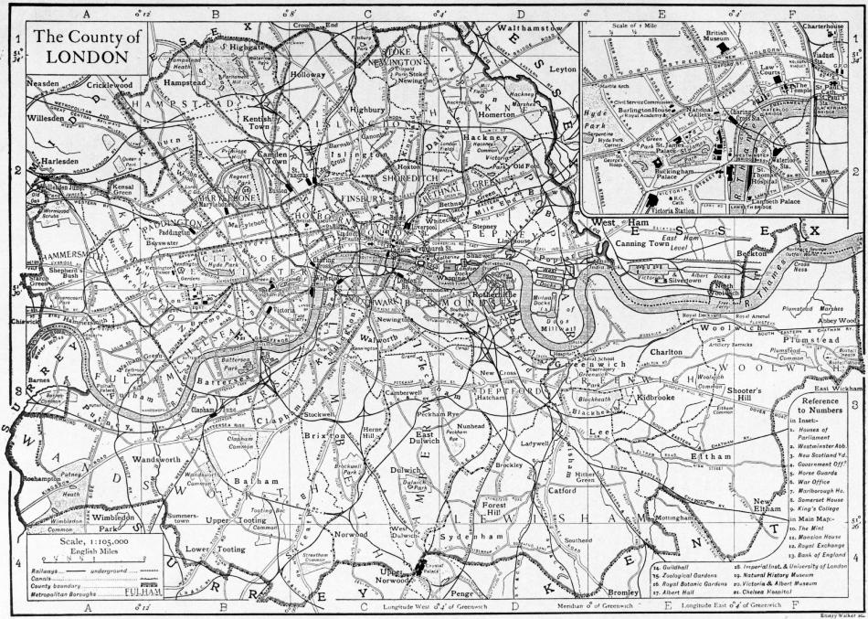
LONDON, the capital of England and of the British Empire, and the greatest city in the world, lying on each side of the river Thames 50 m. above its mouth.1 The “City,” so called both formally and popularly, is a small area (673 acres) on the north bank of the river, forming the heart of the metropolis, and constituting within its boundaries one only, and one of the smallest, of twenty-nine municipal divisions which make up the administrative County of London. The twenty-eight remaining divisions are the Metropolitan Boroughs. The county thus defined has an extreme length (E. to W.) of 16 m., an extreme breadth (N. to S.) of 11½ m., and an area of 74,839 acres or about 117 sq. m. The boroughs are as follows:—
1. North of the Thames.—Touching the northern boundary of the county, from W. to E.—Hammersmith, Kensington, Paddington, Hampstead, St Pancras, Islington, Stoke Newington, Poplar.
Bounded by the Thames—Fulham, Chelsea, the City of Westminster (here the City of London intervenes), Stepney, Poplar.
Between Westminster, the City and Stepney, and the northern boroughs—St Marylebone (commonly Marylebone), Holborn, Finsbury, Shoreditch, Bethnal Green.
2. South of the Thames.—Wandsworth, Battersea, Lambeth, Southwark, Camberwell, Bermondsey, Deptford, Lewisham, Greenwich, Woolwich (with a small part of the north bank).
These names are all in common use, though their formal application is in some cases extended over several districts of which the ancient names remain familiar. Each borough is noticed in a separate article.
I. Extent and Site
The County of London is bounded N. and W. by Middlesex, E. by Essex and Kent, S. by Kent and Surrey. The Metropolitan police area, or “Greater London,” however, embraces the whole of Middlesex, with parts of the other three counties and of Hertfordshire. Its extent is 443,419 acres or nearly 693 sq. m., and its population is about seven millions. Only here and there upon its fringe the identity of this great area with the metropolis is lost to the eye, where open country remains unbroken by streets or close-set buildings.
Site.—North of the Thames, and west of its tributary the Lea, which partly bounds the administrative county on the east, London is built upon a series of slight undulations, only rarely sufficient to make the streets noticeably steep. On the northern boundary of the county a height of 443 ft. is found on the open Hampstead Heath. The lesser streams which flow from this high ground to the Thames are no longer open. Some, however, as well as other natural features effaced by the growth of the city, retain an historical interest through the survival of their names in streets and districts, or through their relation to the original site of London (in the present City). South of the Thames a broken amphitheatre of low hills, approaching the river near Greenwich and Woolwich on the east and Putney and Richmond on the west, encloses a tract flatter than that to the north, and rises more abruptly in the southern districts of Streatham, Norwood and Forest Hill.
In attempting to picture the site of London in its original condition, that is, before any building took place, it is necessary to consider (1) the condition of the Thames unconfined between made banks, (2) the slopes overlooking it, (3) the tributary streams which watered these slopes. The low ground between the slight hills flanking the Thames valley, and therefore mainly south of the present river, was originally occupied by a shallow lagoon of estuarine character, tidal, and interspersed with marshy tracts and certain islets of relatively firm land. Through this the main stream of the Thames pursued an ill-defined course. The tributary streams entered through marshy channels. The natural process of sedimentation assisted the gradual artificial drainage of the marshes by means of embankments confining the river. The breadth of this low tract, from Chelsea downward, was from 2 to 3 m. The line of the foot of the southern hills, from Putney, where it nearly approaches the present river, lies through Stockwell and Camberwell to Greenwich, where it again approaches the river. On the north there is a flat tract between Chelsea and Westminster, covering Pimlico, but from Westminster down to the Tower there is a marked slope directly up from the river bank. Lower still, marshes formerly extended far up the valley of the Lea. The higher slopes of the hills were densely forested (cf. the modern district-name St John’s Wood), while the lower slopes, north of the river, were more open (cf. Moor-gate). The original city grew up on the site of the City of London of the present day, on a slight eminence intersected by the Wal- or Wall-brook, and flanked on the west by the river Fleet.
(Click to enlarge.)
These and other tributary streams have been covered in and built over (in some cases serving as sewers), but it is possible to trace their valleys at various points by the fall and rise of streets crossing them, and their names survive, as will be seen, in various modern applications. The Wallbrook rose in a marsh in the modern district of Finsbury, and joined the Thames close to the Cannon Street railway bridge. A street named after it runs south from the Mansion House parallel with its course. The Fleet was larger, rising in, and collecting various small streams from, the high ground of Hampstead. It passed Kentish Town, Camden Town and King’s Cross, and followed a line approximating to King’s Cross Road. The slope of Farringdon Road, where crossed by Holborn Viaduct, and of New Bridge Street, Blackfriars, marks its course exactly, and that of Fleet Street and Ludgate Hill its steep banks. The name also appears in Fleet Road, Hampstead. From King’s Cross downward the banks were so steep and high that the stream was called Hollow or Hole-bourne, this name surviving in Holborn; and it was fed by numerous springs (Bagnigge Well, Clerkenwell and others) in this vicinity. It entered a creek which was navigable for a considerable distance, and formed a subsidiary harbour for the City, but by the 14th century this was becoming choked with refuse, and though an attempt was made to clear it, and wharves were built in 1670, it was wholly arched over in 1737-1765 below Holborn Bridge. Continuing westward, the most important stream was Tyburn (q.v.), which rose at Hampstead, and joined the Thames through branches on either side of Thorney Island, on which grew up the great ecclesiastical foundation of St Peter, Westminster, better known as Westminster Abbey. There is no modern survival of the name of Tyburn, which finds, indeed, its chief historical interest as attaching to the famous place of execution which lay near the modern Marble Arch. The residential district in this vicinity was known at a later date as Tyburnia. The next stream westward was the Westbourne, the name of which is perpetuated in Westbourne Grove and elsewhere in Paddington. It rose on the heights of Hampstead, traversed Paddington, may be traced in the course of the Serpentine lake in Hyde Park, ran parallel to and east of Sloane Street, and joined the Thames close to Chelsea Bridge. The main tributaries of the Thames from the north, to east and west of those described, are not covered, nor is any tributary of importance from the south entirely concealed.
Geology.—London lies within the geological area known as the London basin. Within the confines of Greater London the chalk which forms the basement of this area appears at the surface in isolated patches about Greenwich, while its main line approaches within 10 m. of the City to the south and within 15 to the north-west. In the south and north-west the typical London clay is the principal formation. In the south-east, however, the Blackheath and Woolwich pebble-beds appear, with their belts of Thanet sands bordering the chalk. Valley gravel borders the Thames, with some interruptions, from Kingston to Greenwich, and extends to a wide belt, with ramifications, from Wandsworth south to Croydon, and in a narrower line from Greenwich towards Bromley. Brick earth overlies it from Kensington to Brentford and west thereof, and appears in Chelsea and Fulham, Hornsey and Stoke Newington, and in patches south of the Thames between Battersea and Richmond. The main deposits of alluvium occur below Lambeth and Westminster, and in the valley of the Wandle, which joins the Thames from the south near Putney. In the north and west the clay is interspersed with patches of plateau gravel in the direction of Finchley (where boulder clay also appears), Enfield and Barnet; and of Bagshot sands on Hampstead Heath and Harrow Hill. Gravel is found on the high ground about Richmond Park and Wimbledon. (See further Middlesex.)
Climate.—The climate is equable (though excessive heat is sometimes felt for short periods during the summer) and moist, but healthy. Snow is most common in the early months of the year. The fogs of London have a peculiar and perhaps an exaggerated notoriety. They are apt to occur at all seasons, are common from September to February, and most common in November. The atmosphere of London is almost invariably misty in a greater or less degree, but the denser fogs are generally local and of no long duration. They sometimes cause a serious dislocation of railway and other traffic. Their principal cause is the smoke from the general domestic use of coal. The evil is of very long standing, for in 1306 the citizens petitioned Edward I. to prohibit the use of sea-coal, and he made it a capital offence. The average temperature of the hottest month, July, is 64°.4 F.; of the coldest, January, 37°.9; and the mean annual 50°.4. The mean annual rainfall ranges in different parts of the metropolis from about 20½ to 27½ in.
II. Topography
London as a whole owes nothing in appearance to the natural configuration of its site. Moreover, the splendid building is nearly always a unit; seldom, unless accidentally, a component part of a broad effect. London has not grown up along formal lines; nor is any large part of it laid out according to the conceptions of a single generation. Yet not a few of the great thoroughfares and buildings are individually worthy of London’s preeminence as a city. The most notable of these fall within a circumscribed area, and it is therefore necessary to preface their consideration with a statement of the broader characteristic divisions of the metropolis.
Characteristic Divisions.—In London north of the Thames, the salient distinction lies between West and East. From the western boundary of the City proper, an area covering the greater part of the city of Westminster, and extending into Chelsea, Kensington, Paddington and Marylebone, is exclusively associated with the higher-class life of London. Within the bounds of Westminster are the royal palaces, the government offices and many other of the finest public buildings, and the wider area specified includes the majority of the residences of the wealthier classes, the most beautiful parks and the most fashionable places of recreation. “Mayfair,” north of Piccadilly, and “Belgravia,” south of Knightsbridge, are common though unofficial names for the richest residential districts. The “City” bears in the great commercial buildings fringing its narrow streets all the marks of a centre of the world’s exchanges. East of it there is an abrupt transition to the district commonly known as the “East End,” as distinguished from the wealthy “West End,” a district of mean streets, roughly coincident with the boroughs of Stepney and Poplar, Shoreditch and Bethnal Green, and primarily (though by no means exclusively) associated with the problems attaching to the life of the poor. On the Thames below London Bridge, London appears in the aspect of one of the world’s great ports, with extensive docks and crowded shipping. North London is as a whole residential: Hackney, Islington and St Pancras consist mainly of dwellings of artisans and the middle classes; while in Hampstead, St Marylebone and Paddington are many terraces and squares of handsome houses. Throughout the better residential quarters of London the number of large blocks of flats has greatly increased in modern times. But even in the midst of the richest quarters, in Westminster and elsewhere, small but well-defined areas of the poorest dwellings occur.
London south of the Thames has none of the grander characteristics of the wealthy districts to the north. Poor quarters lie adjacent to the river over the whole distance from Battersea to Greenwich, merging southward into residential districts of better class. London has no single well-defined manufacturing quarter.
Suburbs.—Although the boundary of the county of London does not, to outward appearance, enclose a city distinct from its suburbs, London outside that boundary may be conveniently considered as suburban. Large numbers of business men and others who must of necessity live in proximity to the metropolis have their homes aloof from its centre. It is estimated that upwards of a million daily enter and leave the City alone as the commercial heart of London, and a great proportion of these travel in and out by the suburban railways. In this aspect the principal extension of London has been into the counties of Kent and Surrey, to the pleasant hilly districts about Sydenham, Norwood and Croydon, Chislehurst and Orpington, Caterham, Redhill and Reigate, Epsom, Dorking and Leatherhead; and up the valley of the Thames through Richmond to Kingston and Surbiton, Esher and Weybridge, and the many townships on both the Surrey and the Middlesex shores of the river. On the west and north the residential suburbs immediately outside the county include Acton and Ealing, Willesden, Highgate, Finchley and Hornsey; from the last two a densely populated district extends north through Wood Green and Southgate to Barnet and Enfield; while the “residential influence” of the metropolis far exceeds these limits, and may be observed at Harrow and Pinner, Bushey and Boxmoor, St Albans, Harpenden, Stevenage and many other places. To the north-east the beauty of Epping Forest attracts numerous residents to Woodford, Chingford and Loughton. The valley of the Lea is also thickly populated, but chiefly by an industrial population working in the numerous factories along this river. The Lea separates the county of London from Essex, but the townships of West Ham and Stratford, Barking and Ilford, Leyton and Walthamstow continue the metropolis in this direction almost without a break. Their population is also largely occupied in local manufacturing establishments; while numerous towns on either bank of the lower Thames share in the industries of the port of London.
Streets.—The principal continuous thoroughfares within the metropolis, though each bears a succession of names, are coincident with the main roads converging upon the capital from all parts of England. On the north of the Thames two great thoroughfares from the west meet in the heart of the City. The northern enters the county in Hammersmith as Uxbridge Road, crosses Kensington and borders the north side of Kensington Gardens and Hyde Park as Bayswater Road. It then bears successively the names of Oxford Street, New Oxford Street and High Holborn; enters the City, becomes known as Holborn Viaduct from the fact that it is there carried over other streets which lie at a lower level, and then as Newgate Street and Cheapside. The southern highway enters Hammersmith, crosses the centre of Kensington as Kensington Road and High Street, borders Kensington Gardens and Hyde Park as Kensington Gore and Knightsbridge, with terraces of fine residences, and merges into Piccadilly. This beautiful street, with its northward branches, Park Lane, from which splendid houses overlook Hyde Park, and Bond Street, lined with handsome shops, may be said to focus the fashionable life of London. The direct line of the thoroughfare is interrupted after Piccadilly Circus (the term “circus” is frequently applied to the open space—not necessarily round—at the junction of several roads), but is practically resumed in the Strand, with its hotels, shops and numerous theatres, and continued through the City in Fleet Street, the centre of the newspaper world, and Ludgate Hill, at the head of which is St Paul’s Cathedral. Thence it runs by commercial Cannon Street to the junction with Cheapside and several other busy streets. At this junction stand the Royal Exchange, the Mansion House (the official residence of the Lord Mayor of London) and the Bank of England, from which this important point in the communications of London is commonly known as “Bank.” From the east two main roads similarly converge upon the City, which they enter by Aldgate (the suffix in this and other names indicating the former existence of one of the City gates). The southern of these highways, approaching through the eastern suburbs as Barking Road, becomes East India Docks Road in Poplar and Commercial Road East in Stepney. The continuous thoroughfare of 12 m. between Hammersmith and the East India Docks illustrates successively every phase of London life. The northern road enters from Stratford and is called Bow Road, Mile End Road, Whitechapel Road and High Street, Whitechapel. From the north of England two roads preserve communication-lines from the earliest times. The Old North Road, entering London from the Lea valley through Hackney and Shoreditch as Stamford Hill, Stoke Newington Road and Kingsland Road, reaches the City by Bishopsgate. The straight highway from the north-west which as Edgware Road joins Oxford Street at the Marble Arch (the north-eastern entrance to Hyde Park) is coincident with the Roman Watling Street. The Holyhead and Great North Roads, uniting at Barnet, enter London by branches through Hampstead and through Highgate, between the Old North and Edgware roads. South of the Thames the thoroughfares crossing the river between Lambeth and Bermondsey converge upon two circuses, St George’s and the Elephant and Castle. At the second of these points the majority of the chief roads from the southern suburbs and the south of England are collected. Among them, the Old Kent Road continues the southern section of Watling Street, from Dover and the south-east, through Woolwich and across Blackheath. The road through Streatham, Brixton and Kennington, taking name from these districts successively, is the principal southern highway. The Portsmouth Road from the south-west is well marked as far as Lambeth, under the names of Wandsworth, High Street, St John’s Hill, Lavender Hill and Wandsworth Road.
Thames Embankments.—The Thames follows a devious course through London, and the fine embankments on its north side, nowhere continuing uninterruptedly for more than 2 m., do not form important thoroughfares, with the exception of the Victoria Embankment. Mostly they serve rather as beautiful promenades. One of them begins over against Battersea Bridge. Its finest portion is the Chelsea Embankment, fronting Battersea Park across the river, shaded by a pleasant avenue and lined with handsome houses. It continues, with some interruptions, nearly as far as the Houses of Parliament. Below these the grandest of the embankments extends to the City at Blackfriars. It was formed in 1864-1870, and is named the Victoria Embankment, though its popular title is “The Embankment” simply. Open gardens fringe it in part on the landward side, and it is lined with fine public and private buildings. The bold sweep of the Thames, here some 300 yds. wide, the towers of Westminster on the one hand and the dome of St Paul’s on the other, make up a fine prospect. Below London Bridge the river is embanked for a short distance in front of the Tower of London, and above Westminster Bridge the Albert Embankment extends for nearly 1 m. along the south bank.
Bridges.—Fourteen road-bridges cross the Thames within the county of London. Of these London Bridge, connecting the City with Southwark and Bermondsey, stands first in historical interest and in importance as a modern highway. The old bridge, famous for many generations, bearing its rows of houses and its chapel in the centre, was completed early in the 13th century. It was 308 yds. long and had twenty narrow arches, through which the tides formed dangerous rapids. It stood just below the existing bridge, which was built of granite by John Rennie and his son Sir John Rennie, and completed in 1831. A widening to accommodate the growth of traffic, after being frequently discussed for many years, was completed in 1904, by means of corbels projecting on either side, without arresting traffic during the work. There was no bridge over the Thames below London Bridge until 1894, when the Tower Bridge was opened. This is a suspension bridge with a central portion, between two lofty and massive stone towers, consisting of bascules which can be raised by hydraulic machinery to admit the passage of vessels. The bridge is both a remarkable engineering work, and architecturally one of the finest modern structures in London. The bridges in order above London Bridge are as follows, railway-bridges being bracketed—Southwark, (Cannon Street), (Blackfriars), Blackfriars, Waterloo, (Hungerford—with a footway), Westminster, Lambeth, Vauxhall, (Grosvenor), Victoria, Albert, Battersea, (Battersea), Wandsworth, (Putney), Putney and Hammersmith. Waterloo Bridge, the oldest now standing within London, is the work of John Rennie, and was opened in 1817. It is a massive stone structure of nine arches, carrying a level roadway, and is considered one of the finest bridges of its kind in the world. The present Westminster Bridge, of iron on granite piers, was opened in 1862, but another preceded it, dating from 1750; the view from which was appreciated by Wordsworth in his sonnet beginning “Earth has not anything to show more fair.” The complete reconstruction of Vauxhall Bridge was undertaken in 1902, and the new bridge was opened in 1906. Some of the bridges were built by companies, and tolls were levied at their crossing until modern times; thus Southwark Bridge was made toll-free in 1866, and Waterloo Bridge only in 1878, on being acquired by the City Corporation and the Metropolitan Board of Works respectively. The road-bridges mentioned (except the City bridges) are maintained by the London County Council, who expended for this purpose a sum of £9149 in 1907-1908. The following table shows the capital expenditure on the more important bridges and their cost of maintenance in 1907-1908:—
Net Capital Expenditure. Cost of Maintenance 1907-1908.
Albert Bridge £120,774 £1296
Battersea Bridge 312,193 512
Hammersmith Bridge 204,250 421
Lambeth Bridge 47,555 496
Putney Bridge 430,052 653
Vauxhall Bridge (temporary) 270,749 73
Vauxhall Bridge (new) 457,108 1109
Wandsworth Bridge 65,661 410
Waterloo Bridge 552,867 1102
Westminster Bridge 393,189 1491
The properties entrusted to the Corporation for the upkeep of London Bridge are managed by the Bridge House Estates Committee, the revenues from which are also used in the maintenance of the other three City bridges, £26,989 being thus expended in 1907, the Tower bridge absorbing £17,735 of this amount.
Thames Tunnels.—Some of the metropolitan railway lines cross the river in tunnels beneath its bed. There are also several tunnels under the river below London Bridge, namely: Tower Subway, constructed in 1870 for foot-passengers, but no longer used, Greenwich Tunnel (1902) for foot-passengers, Blackwall Tunnel (1897), constructed by the County Council between Greenwich and Poplar, and Woolwich Tunnel, begun in 1910. A tunnel between Rotherhithe and Ratcliff was authorized in 1897 and opened in 1908. The Thames Tunnel (1825-1843), 2 m. below London Bridge, became a railway tunnel in 1865. The County Council maintains a free ferry at Woolwich for passengers and vehicular traffic. The capital expenditure on this undertaking was £185,337 and the expense of maintenance in 1907-1908 £20,881. The Greenwich Tunnel (capital expenditure £179,293) in the same year had expended on it for maintenance £3725, and the Blackwall Tunnel (capital expenditure £1,268,951) £11,420. The capital expenditure on the Rotherhithe Tunnel was £1,414,561.
Parks.—The administration and acreage of parks and open spaces, and their provisions for the public recreation, fall for consideration later, but some of them are notable features in the topography of London. The royal parks, namely St James’s, Green and Hyde Park, and Kensington Gardens, stretch in an irregular belt for nearly 3 m. between Whitehall (Westminster) and Kensington. St James’s Park was transformed from marshy land into a deer park, bowling green and tennis court by Henry VIII., extended and laid out as a pleasure garden by Charles II., and rearranged according to the designs of John Nash in 1827-1829. Its lake, the broad Mall leading up to Buckingham Palace, and the proximity of the government buildings in Whitehall, combine to beautify it. Here was established, by licence from James I., the so-called Milk Fair, which remained, its ownership always in the same family, until 1905, when, on alterations being made to the Mall, a new stall was erected for the owners during their lifetime, though the cow or cows kept here were no longer allowed. St James’s Park is continued between the Mall and Piccadilly by the Green Park. Hyde Park, to the west, belonged originally to the manor of Hyde, which was attached to Westminster Abbey, but was taken by Henry VIII. on the dissolution of the monasteries. Two of its gateways are noteworthy, namely that at Hyde Park Corner at the south-east and the Marble Arch at the north-east. The first was built in 1828 from designs of Decimus Burton, and comprises three arches with a frieze above the central arch copied from the Elgin marbles in the British Museum. The Marble Arch was intended as a monument to Nelson, and first stood in front of Buckingham Palace, being moved to its present site in 1851. It no longer forms an entrance to the park, as in 1908 a corner of the park was cut off and a roadway was formed to give additional accommodation for the heavy traffic between Oxford Street, Edgware Road and Park Lane. The Marble Arch was thus left isolated. Hyde Park contains the Serpentine, a lake 1500 yds. in length, from the bridge over which one of the finest prospects in London is seen, extending to the distant towers of Westminster. Since the 17th century this park has been one of the most favoured resorts of fashionable society, and at the height of the “season,” from May to the end of July, its drives present a brilliant scene. In the 17th and 18th centuries it was a favourite duelling-ground, and in the present day it is not infrequently the scene of political and other popular demonstrations (as is also Trafalgar Square), while the neighbourhood of Marble Arch is the constant resort of orators on social and religious topics. Kensington Gardens, originally attached to Kensington Palace, were subsequently much extended; they are magnificently timbered, and contain plantations of rare shrubs and flowering trees. Regent’s Park, mainly in the borough of Marylebone, owes its preservation to the intention of George III. to build a palace here. The other most notable open spaces wholly or partly within the county are Hampstead Heath in the north-west, a wild, high-lying tract preserved to a great extent in its natural state, and in the south-west Wimbledon Common, Putney Heath and the royal demesne of Richmond Park, which from its higher parts commands a wonderful view up the rich valley of the Thames. The outlying parts of the county to east, south and north are not lacking in open spaces, but there is an extensive inner area where at most only small gardens and squares break the continuity of buildings, and where in some cases old churchyards serve as public grounds.
Architecture.—While stone is the material used in the construction of the majority of great buildings of London, some modern examples (notably the Westminster Roman Catholic cathedral) are of red brick with stone dressings; and brick is in commonest use for general domestic building. The smoke-laden atmosphere has been found not infrequently to exercise a deleterious effect upon the stonework of important buildings; and through the same cause the appearance of London as a whole is by some condemned as sombre. Bright colour, in truth, is wanting, though attempts are made in a few important modern erections to supply it, a notable instance being the Savoy Hotel buildings (1904) in the Strand. Portland stone is frequently employed in the larger buildings, as in St Paul’s Cathedral, and under the various influences of weather and atmosphere acquires strongly contrasting tones of light grey and black. Owing to the by-laws of the County Council, the method of raising commercial or residential buildings to an extreme height is not practised in London; the block known as Queen Anne’s Mansions, Westminster, is an exception, though it cannot be called high in comparison with American high buildings.
Architectural remains of earlier date than the Norman period are very few, and of historical rather than topographical importance. In architecture of the Norman and Gothic periods London must be considered rich, though its richness is poverty Ecclesiastical architecture. when its losses, particularly during the great fire of 1666, are recalled. These losses were confined within the City, but, to go no farther, included the Norman and Gothic cathedral of St Paul, perhaps a nobler monument of its period than any which has survived it, much as it had suffered from injudicious restoration. Ancient architecture in London is principally ecclesiastical. Westminster Abbey is pre-eminent; in part, it may be, owing to the reverence felt towards it in preference to the classical St Paul’s by those whose ideal of a cathedral church is essentially Gothic, but mainly from the fact that it is the burial-place of many of the English monarchs and their greatest subjects, as well as the scene of their coronations (see Westminster). In the survey of London (1598) by John Stow, 125 churches, including St Paul’s and Westminster Abbey, are named; of these 89 were destroyed by the great fire. Thirteen large conventual churches were mentioned by Fitzstephen in the time of Henry II., and of these there are some remains.
The church of St Bartholomew the Great, Smithfield, is the finest remnant of its period in London. It was founded in 1123 by Rahere, who, probably a Breton by birth, was a courtier in the reign of William II. He is said to have been the king’s minstrel, and to have spent the earlier part of his life in frivolity. Subsequently he entered holy orders, and in c. 1120, being stricken with fever while on a pilgrimage to Rome, vowed that he would found a hospital in London. St Bartholomew, appearing to him in a vision, bade him add a church to his foundation. He became an Augustinian canon, and founded his hospital, which is now, as St Bartholomew’s Hospital, one of the principal medical institutions in the metropolis. He became its first master. Later he erected the priory, for canons of his order, of which the nave and transepts of the church remain. The work is in the main very fine Norman, with triforium, ambulatory and apsidal eastern end. An eastern lady chapel dates from c. 1410, but the upper part is modern, for the chapel was long desecrated. There are remains of the cloisters north of the church,—and praiseworthy efforts have been made since 1903 towards their restoration. The western limit of the former nave of the church is marked by a fine Early English doorway, now forming an entrance to the churchyard. Rahere’s tomb remains in the church; the canopy is Perpendicular work, but the effigy is believed to be original. He died in 1144.
The Temple Church (see Inns of Court), serving for the Inner and Middle Temples, belonged to the Knights Templars. It is the finest of the four ancient round churches in England, dating from 1185, but an Early English choir opens from the round church. St Saviour’s in Southwark (q.v.), the cathedral church of the modern bishopric of Southwark, was the church of the priory of St Mary Overy, and is a large cruciform building mainly Early English in style. There may be mentioned also an early pier in the church of St Katherine Cree or Christ Church, Leadenhall Street, belonging to the priory church of the Holy Trinity; old monuments in the vaults beneath St James’s Church, Clerkenwell, formerly attached to a Benedictine nunnery; and the Perpendicular gateway and the crypt of the church of the priory of St John of Jerusalem (see Finsbury). Among other ancient churches within the City, that of All Hallows Barking, near the Tower of London, is principally Perpendicular and contains some fine brasses. It belonged to the convent at Barking, Essex, and was the burial-place of many who were executed at the scaffold on Tower Hill. St Andrew Undershaft, so named because a Maypole used to be set up before the former church on May-day, is late Perpendicular (c. 1530); and contains a monument to John Stow the chronicler (d. 1605). The church of Austin Friars, originally belonging to a friary founded in 1253, became a Dutch church under a grant of Edward VI., and still remains so; its style is principally Decorated, but through various vicissitudes little of the original work is left. St Giles, Cripplegate, was founded c. 1090, but the existing church is late Perpendicular. It is the burial-place of Fox the martyrologist and Milton the poet, and contains some fine wood-carving by Grinling Gibbons. St Helen’s, Bishopsgate, belonged to a priory of nuns founded c. 1212, but the greater part of the building is later. It has two naves parallel, originally for the use of the nuns and the parishioners respectively. The church of St Mary-le-Bow, in Cheapside, is built upon a Norman crypt, and that of St Olave’s, Hart Street, which was Pepys’s church and contains a modern memorial to him, is of the 15th century. Other ancient churches outside the City are few; but there may be noted St Margaret’s, under the shadow of Westminster Abbey; and the beautiful Ely Chapel in Holborn (q.v.), the only remnant of a palace of the bishops of Ely, now used by the Roman Catholics. The Chapel Royal, Savoy, near the Strand, was rebuilt by Henry VII. on the site of Savoy Palace, which was erected by Peter, earl of Savoy and Richmond, in 1245, and destroyed in the insurrection of Wat Tyler in 1381. In 1505 Henry VII. endowed here a hospital of St John the Baptist for the poor. The chapel was used as the parish church of St Mary-le-Strand (1564-1717) and constituted a Chapel Royal in 1773; but there are no remains of the rest of the foundation.
The architect to whom, after the great fire of 1666, the opportunity fell of leaving the marks of his influence upon London was Sir Christopher Wren. Had all his schemes been followed out, that influence would have extended beyond architecture Sir Christopher Wren. alone. He, among others, prepared designs for laying out the City anew. But no such model city was destined to be built; the necessity for haste and the jealous guardianship of rights to old foundations resulted in the old lines being generally followed. It is characteristic of London that St Paul’s Cathedral (q.v.) should be closely hemmed in by houses, and its majestic west front approached obliquely by a winding thoroughfare. The cathedral is Wren’s crowning work. It is the scene from time to time of splendid ceremonies, and contains the tombs of many great men; but in this respect it cannot compete with the peculiar associations of Westminster Abbey. Of Wren’s other churches it is to be noted that the necessity of economy usually led him to pay special attention to a single feature. He generally chose the steeple, and there are many fine examples of his work in this department. The steeple of St Mary-le-Bow, commonly called Bow Church, is one of the most noteworthy. This church has various points of interest besides its Norman crypt, from which it took the name of Bow, being the first church in London built on arches. The ecclesiastical Court of Arches sat here formerly. “Bow bells” are famous, and any person born within hearing of them is said to be a “Cockney,” a term now applied particularly to the dialect of the lower classes in London. Wren occasionally followed the Gothic model, as in St Antholin. The Later churches. classic style, however, was generally adopted in the period succeeding his own. Some fine churches belong to this period, such as St Martin’s-in-the-Fields (1726), the Corinthian portico of which rises on the upper part of Trafalgar Square; but other examples are regrettable. While the architecture of the City churches, with the exceptions mentioned, is not as a rule remarkable, many are notable for the rich and beautiful wood-carving they contain. A Gothic style has been most commonly adopted in building modern churches; but of these the most notable, the Roman Catholic Westminster Cathedral (see Westminster), is Byzantine, and built principally of brick, with a lofty campanile. The only other ecclesiastical building to be specially mentioned is Lambeth Palace, opposite to the Houses of Parliament across the Thames. It has been a seat of the archbishops of Canterbury since 1197, and though the present residential portion dates only from the early 19th century, the chapel, hall and other parts are of the 13th century and later (see Lambeth).
Among secular buildings, there is none more venerable than the Tower of London (q.v.), the moated fortress which overlooks the Tower of London. Thames at the eastern boundary of the City. It presents fine examples of Norman architecture; its historical associations are of the highest interest, and its armoury and the regalia of England, which are kept here, attract great numbers of visitors.
The Houses of Parliament, with Westminster Abbey and St Margaret’s Church, complete the finest group of buildings which London possesses; a group essentially Gothic, for the Houses of Parliament, completed in 1867 from the designs Government buildings. of Barry, are in a late Perpendicular style. They cover a great area, the east front giving immediately upon the Thames. The principal external features are the huge Victoria Tower at the south, and the clock tower, with its well-known chimes and the hour-bell “Big Ben,” on the north. Some of the apartments are magnificently adorned within, and the building incorporates the ancient Westminster Hall, belonging to the former royal palace on the site (see Westminster). The government offices are principally in Whitehall, the fine thoroughfare which connects Parliament Square, in the angle between the Houses and the Abbey, with Trafalgar Square. Somerset House (1776-1786), a massive range of buildings by Sir William Chambers, surrounding a quadrangle, and having its front upon the Strand and back upon the Victoria Embankment, occupies the site of a palace founded by the protector Somerset, c. 1548. It contains the Exchequer and Audit, Inland Revenue, Probate, Registrar-General’s and other offices, and one wing houses King’s College. Other offices are the New Record Office, the repository of State papers and other records, and the Patent Office in Chancery Lane. The Heralds’ College or College of Arms, the official authority in matters of armorial bearings and pedigrees, occupies a building in Queen Victoria Street, City, erected subsequently to the great fire (1683). The Royal Courts of Justice or Law Courts stand adjacent to the Inns of Court, facing the Strand at the point where a memorial marks the site of Old Temple Bar (1672), at the entrance to the City, removed in 1878 and later re-erected at Theobald’s Park, near Cheshunt, Hertfordshire. The Law Courts (1882) were erected from the designs of G. E. Street, in a Gothic style.
The buildings connected with local government in London are with one exception modern, and handsome town-halls have been erected for some of the boroughs. The exception is the Guildhall (q.v.) of the City Corporation, with its splendid hall, the scene of meetings and entertainments of the corporation, its council chamber, library and crypt (partly opened to the public in 1910). In 1906 the London County Council obtained parliamentary sanction for the erection of a county hall on the south bank of the Thames, immediately east of Westminster Bridge, and in 1908 a design submitted by Mr Ralph Knott was accepted in competition. The style prescribed was English Renaissance. Several of the great livery companies or gilds of the City possess fine halls, containing portraits and other collections of high interest and value. Among the more notable of these halls are those of the Mercers, Drapers, Fishmongers, Clothworkers, Armourers and Stationers.
The former royal palaces of Westminster and of Whitehall, of which the fine Jacobean banqueting hall remains, are described under Westminster. The present London residence of the sovereign is Buckingham Palace, on the west side of St Royal palaces. James’s Park, with beautiful gardens behind it. Buckingham House was built in 1705 for the duke of Buckinghamshire, and purchased by George III. in 1762. The existing palace was finished by John Nash in 1835, but did not meet with approval, and was considerably altered before Queen Victoria occupied it in 1837. As regards its exterior appearance it is one of the least satisfactory of London’s great buildings, though the throne room and other state apartments are magnificent within. The picture gallery contains valuable works of Dutch masters and others. The front of the palace forms the background to the public memorial to Queen Victoria, at the head of the Mall. Provision was made in the design, by Sir Aston Webb, for the extension of the Mall to open upon Trafalgar Square, through gateways in a semicircular range of buildings to be occupied by government offices, and for a wide circular space in front of the Palace, with a statue of the Queen by Thomas Brock in its centre. St James’s Palace, at the north side of St James’s Park, was acquired and rebuilt by Henry VIII., having been formerly a hospital founded in the 12th century for leprous maidens. It was the royal residence after the destruction of Whitehall by fire in the time of William III. until a fire in 1809 destroyed the greater part. Only the gateway and certain apartments remain of the Tudor building. Marlborough House, adjacent to the palace, was built by the first duke of Marlborough in 1710 from the designs of Wren, came into possession of the Crown in 1817, and has been occupied since 1863 by the prince of Wales. In Kensington (q.v.), on the west side of Kensington Gardens, is the palace acquired by William III. as a country seat, and though no longer used by the sovereign, is in part occupied by members of the royal family, and possesses a deeper historical interest than the other royal palaces, as the birthplace of Queen Victoria and her residence in youth.