VOLUME XV SLICE VI Justinian II. to Kells (continued 3)
Reading edition
Kabīr’s fame as a preacher of bhakti, or enthusiastic devotion to a personal God, whom he preferred to call by the Hindu names of Rāma and Hari, is greater than that of any other of the Vaishnava spiritual leaders. His fervent conviction of the truth and power of his doctrine, and the homely and searching expression given to it in his utterances, in the tongue of the people and not in a learned language remote from their understanding, won for him multitudes of adherents; and his sect, the Kabīrpanthīs, is still one of the most numerous in northern India, its numbers exceeding a million. Its headquarters are the Kabīr Chaurā at Benares, where are preserved the works attributed to Kabīr (called the Granth), the greater part of which, however, were written by his immediate disciples and their followers in his name.
Those works which seem to have the best claim to be considered his own compositions are the Sākhīs, or stanzas, some 5000 in number, which have a very wide currency even among those who do not formally belong to the sect, and the Shabdāwalī, consisting of a thousand “words” (shabd), or short doctrinal expositions. Perhaps some of the Rēkhtas, or odes (100 in number), and of the Ramainīs—brief mystical poems in very obscure language—may also be from his hand. Of these different forms specimens will be found translated in Professor H. H. Wilson’s Sketch of the Religious Sects of the Hindus, i. 79-90. Besides the followers who call themselves by Kabīr’s name, there may be reckoned to him many other religious sects which bear that of some intermediate guru or master, but substantially concur with Kabīr in doctrine and practice. Such, for instance, are the Nānakshāhīs in the United Provinces, the Central Provinces, and Bombay, and the Dādū-panthīs, numerous in Rajpūtānā (Wilson, loc. cit. pp. 103 sqq.); the Sikhs, numbering two and a half millions in the Panjāb, are also his spiritual descendants, and their Granth or Scripture is largely stocked with texts drawn from his works.
Kabīr taught the life of bhakti (faith, or personal love and devotion), the object of which is a personal God, and not a philosophical abstraction or an impersonal quality-less, all-pervading spiritual substance (as in the Vēdānta of Śankarāchārya). His utterances do not, like those of Tulsī Dās, dwell upon the incidents of the human life of Rāma, whom he takes as his type of the Supreme; nevertheless, it is the essence of his creed that God became incarnate to bring salvation to His children, mankind, and that the human mind of this incarnation still subsists in the Divine Person. He proclaims the unity of the Godhead, the vanity of idols, the powerlessness of brāhmans or mullās to guide or help, and the divine origin of the human soul, divinae particula aurae. All evil in the world is ascribed to Māyā, illusion or falsehood, and truth in thought, word and deed is enjoined as the chief duty of man: “No act of devotion can equal truth; no crime is so heinous as falsehood; in the heart where truth abides there is My abode.”3 The distinctions of creeds are declared to be of no importance in the presence of God: “The city of Hara4 is to the east, that of ‘Alī5 is to the west; but explore your own heart, for there are both Rāma and Karīm;”6 “Behold but One in all things: it is the second that leads you astray. Every man and woman that has ever been born is of the same nature as yourself. He, whose is the world, and whose are the children of ‘Alī and Rāma, He is my Guru, He is my Pīr.” He proclaims the universal brotherhood of man, and the duty of kindness to all living creatures. Life is the gift of God, and must not be violated; the shedding of blood, whether of man or animals, is a heinous crime. The followers of Kabīr do not observe celibacy, and live quiet unostentatious lives; Wilson (p. 97) compares them to Quakers for their hatred of violence and unobtrusive piety.
The resemblance of many of Kabīr’s utterances to those of Christ, and especially to the ideas set forth in St John’s gospel, is very striking; still more so is the existence in the ritual of the sect of a sacramental meal, involving the eating of a consecrated wafer and the drinking of water administered by the Mahant or spiritual superior, which bears a remarkable likeness to the Eucharist. Yet, though the deities of Hinduism and the prophet of Islam are frequently mentioned in his sayings, the name of Jesus has nowhere been found in them. It is conjectured that the doctrine of Rāmānand, which came from southern India, has been influenced by the Christian settlements in that region, which go back to very early times. It is also possible that Sūfīism, the pietistic (as distinguished from the theosophic) form of which seems to owe much to eastern Christianity, has contributed some echo of the Gospel to Kabīr’s teaching. A third (but scarcely probable) hypothesis is that the sect has borrowed both maxims and ritual, long after Kabīr’s own time, from the teaching of the Roman Catholic missionaries, who were established at Agra from the reign of Akbar (1556-1605) onwards.
No critical edition of the writings current under the name of Kabīr has yet been published, though collections of his sayings (chiefly the Sākhīs) are constantly appearing from Indian presses. The reader is referred, for a summary account of his life and doctrine, to H. H. Wilson’s Sketch of the Religious Sects of the Hindus (Works, i. 68 sqq.). Dr E. Trumpp’s edition of the Ādi Granth (Introduction, pp. xcvii. sqq.) may also be consulted. Recent publications dealing with the subject are the Rev. G. H. Westcott’s Kabīr and the Kabīr Panth (Cawnpore, 1908), and Mr. M. A. Macauliffe’s The Sikh Religion (Oxford, 1909), vi. 122-316.
(C. J. L.)
1 See article Hindostani Literature.
2 An exactly similar tale is told of Nānak, the first Guru of the Sikhs, who died in 1538.
3 This and the following passages in quotation marks are from Professor Wilson’s translation of 100 Sākhīs, pp. 83-90.
4 Benares; Hara, a name of Śiva.
5 I.e. Mecca.
6 “The Bountiful,” one of the Korānic names of God (Allah).

KABUL, the capital of Afghanistan, standing at an elevation of 6900 ft. above the sea in 34° 32′ N. and 69° 14′ E. Estimated pop. (1901), 140,000. Lying at the foot of the bare and rocky mountains forming the western boundary of the Kabul valley, just below the gorge made by the Kabul River, the city extends a mile and a half east to west and one mile north to south. Hemmed in by the mountains, there is no way of extending it, except in a northerly direction towards the Sherpur cantonment. As the key of northern India, Kabul has been a city of vast importance for countless ages. It commands all the passes which here debouch from the north through the Hindu Kush, and from the west through Kandahar; and through it passed successive invasions of India by Alexander the Great, Mahmud of Ghazni, Jenghiz Khan, Baber, Nadir Shah and Ahmad Shah. Indeed from the time of Baber to that of Nadir Shah (1526-1738) Kabul was part of the empire of Delhi. It is now some 160 m. from the British frontier post of Jamrud near Peshawar.
Kabul was formerly walled; the old wall had seven gates, of which two alone remain, the Lahori and the Sirdar. The city itself is a huddle of narrow and dirty streets, with the Bala Hissar or fort forming the south-east angle, and rising about 150 ft. above the plain. The Amir’s palace is situated outside the town about midway between it and the Sherpur cantonment which lies about a mile to the north-east. Formerly the greatest ornament of the city was the arcaded and roofed bazaar called Chihâr Châtâ, ascribed to Ali Mardan Khan, a noble of the 17th century, who has left behind him many monuments of his munificent public spirit both in Kabul and in Hindustan. Its four arms had an aggregate length of about 600 ft., with a breadth of 30. The display of goods was remarkable, and in the evening it was illuminated. This edifice was destroyed by Sir G. Pollock on evacuating Kabul in 1842 as a record of the treachery of the city.
The tomb of the Sultan Baber stands on a slope about a mile to the west of the city in a charming spot. The grave is marked by two erect slabs of white marble. Near him lie several of his wives and children; the garden was formerly enclosed by a marble wall; a clear stream waters the flower-beds. From the hill that rises behind the tomb there is a noble prospect of his beloved city, and of the all-fruitful plain stretching to the north of it.
After the accession of Abdur Rahman in 1880 the city underwent great changes. The Bala Hissar was destroyed and has never since been entirely rebuilt, and a fortified cantonment at Sherpur (one side of which was represented by the historic Bemaru ridge) had taken the place of the old earthworks of the British occupation of 1842 which were constructed on nearly the same site. The city streets were as narrow and evil-smelling, the surrounding gardens as picturesque and attractive, and the wealth of fruit was as great, as they had been fifty years previously. The amir, however, effected many improvements. Kabul is now connected by well-planned and metalled roads with Afghan Turkestan on the west, with the Oxus and Bokhara on the north, and with India on the east. The road to India was first made by British and is now maintained by Afghan engineers. The road southwards to Ghazni and Kandahar was always naturally excellent and has probably needed little engineering, but the general principle of road-making in support of a military advance has always been consistently maintained, and the expeditions of Kabul troops to Kafiristan have been supported by a very well graded and substantially constructed road up the Kunar valley from Jalalabad to Asmar, and onwards to the Bashgol valley of Kafiristan. The city ways have been improved until it has become possible for wheeled vehicles to pass, and the various roads connecting the suburbs and the city are efficiently maintained. A purely local railway has also been introduced, to assist in transporting building material. The buildings erected by Abdur Rahman were pretentious, but unmarked by any originality in design and hardly worthy representation of the beauty and dignity of Mahommedan architecture. They included a new palace and a durbar hall, a bridge across the river and embankment, a pavilion and garden laid out around the site of Baber’s tomb overlooking the Chardeh valley; and many other buildings of public utility connected with stud arrangements, the manufacture of small arms and ammunition, and the requirements of what may be termed a wholesale shop under European direction, besides hospitals, dispensaries, bazaars, &c. The new palace is within an entrenchment just outside the city. It is enclosed in a fine garden, well planted with trees, where the harem serai (or ladies’ apartments) occupies a considerable space. The public portion of the buildings comprise an ornamental and lofty pavilion with entrances on each side, and a high-domed octagonal room in the centre, beautifully fitted and appointed, where public receptions take place. The durbar hall, which is a separate building, is 60 yards long by 20 broad, with a painted roof supported by two rows of pillars. But the arrangement of terraced gardens and the lightly constructed pavilion which graces the western slopes of the hills overlooking Chardeh are the most attractive of these innovations. Here, on a summer’s day, with the scent of roses pervading the heated air, the cool refreshment of the passing breezes and of splashing fountains may be enjoyed by the officials of the Kabul court, whilst they look across the beauty of the thickly planted plains of Chardeh to the rugged outlines of Paghman and the snows of the Hindu Kush. The artistic taste of the landscape gardening is excellent, and the mountain scenery is not unworthy of Kashmir. It is pleasant to record that the graveyard of those officers who fell in the Kabul campaign of 1879-1880, which lies at the northern end of the Bemaru ridge, is not uncared for.
Kabul is believed to be the Ortospanum or Ortospana of the geographies of Alexander’s march, a name conjectured to be a corruption of Urddhasthâna, “high place.” This is the meaning of the name Bala Hissar. But the actual name is perhaps also found as that of a people in this position (Ptolemy’s Kabolitae), if not in the name of a city apparently identical with Ortospana, Carura, in some copies read Cabura. It was invaded by the Arabs as early as the thirty-fifth year of the Hegira, but it was long before the Mahommedans effected any lasting settlement. In the early Mahommedan histories and geographies we find (according to a favourite Arabic love of jingle) Kâbul and Zâbul constantly associated. Zâbul appears to have been the country about Ghazni. Kabul first became a capital when Baber made himself master of it in 1504, and here he reigned for fifteen years before his invasion of Hindustan. In modern times it became a capital again, under Timur Shah (see Afghanistan), and so has continued both to the end of the Durani dynasty, and under the Barakzais, who now reign. It was occupied by Sir John Keane in 1839, General Pollock in 1842, and again by Sir Frederick, afterwards Lord Roberts, in 1879.
Kabul is also the name of the province including the city so called. It may be considered to embrace the whole of the plains called Koh Daman and Beghram, &c., to the Hindu Kush northward, with the Kohistan or hill country adjoining. Eastward it extends to the border of Jalalabad at Jagdalak; southward it includes the Logar district, and extends to the border of Ghazni; north-westward it includes the Paghman hills, and the valley of the upper Kabul river, and so to the Koh-i-Baba. Roughly it embraces a territory of about 100 m. square, chiefly mountainous. Wheat and barley are the staple products of the arable tracts. Artificial grasses are also much cultivated, and fruits largely, especially in the Koh Daman. A considerable part of the population spends the summer in tents. The villages are not enclosed by fortifications, but contain small private castles or fortalices.
See C. Yate, Northern Afghanistan (1888); J. A. Gray, At the Court of the Amir (1895); Sir T. H. H. Holdich, The Indian Borderland (1901).
(T. H. H.*)
KABUL RIVER, a river of Afghanistan, 300 m. in length. The Kabul (ancient Kophes), which is the most important (although not the largest) river in Afghanistan, rises at the foot of the Unai pass leading over the Sanglakh range, an offshoot of the Hindu Kush towards Bamian and Afghan Turkestan. Its basin forms the province of Kabul, which includes all northern Afghanistan between the Hindu Kush and the Safed Koh ranges. From its source to the city of Kabul the course of the river is only 45 m., and this part of it is often exhausted in summer for purposes of irrigation. Half a mile east of Kabul it is joined by the Logar, a much larger river, which rises beyond Ghazni among the slopes of the Gul Koh (14,200 ft.), and drains the rich and picturesque valleys of Logar and Wardak. Below the confluence the Kabul becomes a rapid stream with a great volume of water and gradually absorbs the whole drainage of the Hindu Kush. About 40 m. below Kabul the Panjshir river joins it; 15 m. farther the Tagao; 20 m. from the Tagao junction the united streams of Alingar and Alishang (rivers of Kafiristan); and 20 m. below that, at Balabagh, the Surkhab from the Safed Koh. Two or three miles below Jalalabad it is joined by the Kunar, the river of Chitral. Thenceforward it passes by deep gorges through the Mohmand hills, curving northward until it emerges into the Peshawar plain at Michni. Soon afterwards it receives the Swat river from the north and the Bara river from the south, and after a further course of 40 m. falls into the Indus at Attock. From Jalalabad downwards the river is navigable by boats or rafts of inflated skins, and is considerably used for purposes of commerce.
KABYLES, or Kabail, a confederation of tribes in Algeria, Tunisia, and a few oases of the Sahara, who form a branch of the great Berber race. Their name is the Arabic gabīlat (pl.: gabāil), and was at first indiscriminately applied by the Arabs to all Berber peoples. The part of Algeria which they inhabit is usually regarded as consisting of two divisions—Great Kabylia and Lesser Kabylia, the former being also known as the Kabylia of the Jurjura (also called Adrar Budfel, “Mountain of Snow”). Physically many Kabyles do not present much contrast to the Arabs of Algeria. Both Kabyle and Arab are white at birth, but rapidly grow brown through exposure to air and sunshine. Both have in general brown eyes and wavy hair of coarse quality, varying from dark brown to jet black. In stature there is perhaps a little difference in favour of the Kabyle, and he appears also to be of heavier build and more muscular. Both are clearly long-headed. Some, however, of the purer type of Kabyles in Kabylia proper have fair skins, ruddy complexions and blue or grey eyes. In fact there are two distinct types of Kabyles: those which by much admixture have approximated to Arab and negroid types, and those which preserve Libyan features. Active, energetic and enterprising, the Kabyle is to be found far from home—as a soldier in the French army, as a workman in the towns, as a field labourer, or as a pedlar or trader earning the means of purchasing his bit of ground in his native village. The Kabyles are Mahommedans of the Sunnite branch and the Malikite rite, looking to Morocco as the nearer centre of their religion. Some of the Kabyles retain their vernacular speech, while others have more or less completely adopted Arabic. The best known of the Kabyle dialects is the Zouave1 or Igaouaouen, those speaking it having been settled on the northern side of the Jurjura at least from the time of Ibn Khaldun; it is the principal basis of Hanoteau’s Essai de grammaire kabyle (Paris, 1858). Unlike their southern brethren, the Kabyles have no alphabet, and their literature is still in the stage of oral transmission, for the most part by professional reciters. Hanoteau’s Poésies populaires de la Kabylie du Jurjura (Paris, 1867) gives the text and translation of a considerable number of historical pieces, proverbial couplets and quatrains, dancing songs, &c.
Consult General L. L. C. Faidherbe and Dr Paul Topinard, Instructions sur l’anthropologie de l’Algérie (Paris, 1874); Melchior Joseph Eugène Daumas, Le Sahara algérien (Paris, 1845) and Mœurs et coutumes de l’Algérie (1857); De Slane’s translation of Ibn Khaldun’s Hist. des Berbères (Algiers, 1852); Aucapitaine, Les Kabyles et la colonie de l’Algérie (Paris, 1864) and Les Beni M’zab (1868); L.J.A.C. Hanoteau and A. Letourneux, La Kabylie et les coutumes kabyles (Paris, 1893); Charmetant, in Jahrbücher der Verbreitung des Glaubens (1874); Masqueray, Formation des cités ... de l’Algérie (1886); Dugas, La Kabylie et le peuple kabyle (Paris, 1878); Récoux, La Démographie de l’Algérie (Paris, 1880); J. Liorel, Races berbères: les Kabyles (Paris, 1893); MacIver and Wilkin, Libyan Notes (1901).
1 From the enlistment of Kabyles speaking the Zouave dialect the Zouave regiments of the French army came to be so called.
KACH GANDAVA, or Kachhi (Kach, Kej, Kiz), a low-lying flat region in Baluchistan separating the Bugti hills from those of Kalat. It is driven, like a wedge, into the frontier mountain system and extends for 150 m. from Jacobabad to Sibi, with nearly as great a breadth at its base on the Sind frontier. Area, 5310 sq. m.; pop. (1901), 82,909. The Mula pass, which connects it with the Kalat highlands, was once (when the ancient city of Kandabel was the capital of Gandava) a much trodden trade highway, and is still a practicable route though no longer a popular one. The soil is fertile wherever it can be irrigated by the floods brought down from the surrounding hills; but much of the central portion is sandy waste. It is traversed by the North-Western railway. The climate is unhealthy in summer, when pestilential hot winds are sometimes destructive to life. The annual rainfall averages only 3 in. Kachhi, though subject to the khan of Kalat, is administered under the tribal system. There are no schools, dispensaries or gaols.
See Baluchistan District Gazetteer, vol. vi. (Bombay, 1907).
KACHIN HILLS, a mountainous tract in Upper Burma, inhabited by the Kachin or Chingpaw, who are known on the Assam frontier as Singphos. Owing to the great number of tribes, sub-tribes and clans of the Kachins, the part of the Kachin hills which has been taken under administration in the Myitkyina and Bhamo districts was divided into 40 Kachin hill tracts (recently reduced to five). Beyond these tracts there are many Kachins in Katha, Möng Mit and the northern Shan States. The country within the Kachin hill tracts is roughly estimated at 19,177 sq. m., and consists of a series of ranges, for the most part running north and south, and intersected by valleys, all leading towards the Irrawaddy, which drains the country. There were 64,405 Kachins enumerated at the census of 1901. Philological investigations show that it is probable that the progenitors of the Kachins or Chingpaw were the Indo-Chinese race who, before the beginnings of history, but after the Môn-Annam wave had covered Indo-China, forsook their home in western China to pour over the region where Tibet, Assam, Burma and China converge, and that the Chingpaw are the residue left round the headquarters of the Irrawaddy and the Chindwin after those branches, destined to become the Tibetans, the Nagas, the Burmans and the Kuki Chins, had gone westwards and southwards. In the middle of the 19th century the southern limit of the Kachins was 200 m. farther north than it is now. Since then the race has been drifting steadily southward and eastward, a vast aggregate of small independent clans united by no common government, but all obeying a common impulse to move outwards from their original seats along the line of least resistance. Now the Kachins are on both sides of the border of Upper Burma, and are a force to be reckoned with by frontier administrators. According to the Kachin Hill Tribes Regulation of 1895, administrative responsibility is accepted by the British government on the left bank of the Irrawaddy for the country south of the Nmaikha, and on the right bank for the country south of a line drawn from the confluence of the Malikha and Nmaikha through the northern limit of the Laban district and including the jade mines. The tribes north of this line were told that if they abstained from raiding to the south of it they would not be interfered with. South of that line peace was to be enforced and a small tribute exacted, with a minimum of interference in their private affairs. On the British side of the border the chief objects have been the disarmament of the tribes and the construction of frontier and internal roads. A light tribute is exacted.
The Kachins have been the object of many police operations and two regular expeditions: (1) Expedition of 1892-93. Bhamo was occupied by the British on the 28th of December 1885, and almost immediately trouble began. Constant punitive measures were carried on by the military police; but in December 1892 a police column proceeding to establish a post at Sima was heavily attacked, and simultaneously the town of Myitkyina was raided by Kachins. A force of 1200 troops was sent to put down the rising. The enemy received their final blow at Palap, but not before three officers were killed, three wounded, and 102 sepoys and followers killed and wounded. (2) Expedition of 1895-96. The continued misconduct of the Sana Kachins from beyond the administrative border rendered punitive measures necessary. They had remained unpunished since the attack on Myitkyina in December 1892. Two columns were sent up, one of 250 rifles from Myitkyina, the other of 200 rifles from Mogaung, marching in December 1895. The resistance was insignificant, and the operations were completely successful. A strong force of military police is stationed at Myitkyina, with several outposts in the Kachin hills, and the country is never wholly free from crimes of violence committed by the Kachins.
KADUR, a district of Mysore state, in southern India, with an area of 2813 sq. m. Pop. (1901), 362,752, showing an increase of 9% in the decade. The larger portion of the district consists of the Malnad or hill country, which contains some of the wildest mountain scenery in southern India. The western frontier is formed by the chain of the Ghats, of which the highest peaks are the Kudremukh (6215 ft.) and the Meniti Gudda (5451 ft.). The centre is occupied by the horse-shoe range of the Baba Budans, containing the loftiest mountain in Mysore, Mulaingiri (6317 ft.). The Maidan or plain country lying beneath the amphitheatre formed by the Baba Budan hills is a most fertile region, well watered, and with the famous “black cotton soil.” The principal rivers are the Tunga and Bhadra, which rise near each other in the Ghats, and unite to form the Tungabhadra, a tributary of the Kistna. The eastern region is watered by the Vedavati. At the point where this river leaves the Baba Budan hills it is embanked to form two extensive tanks which irrigate the lower valley. From all the rivers water is drawn off into irrigation channels by means of anicuts or weirs. The chief natural wealth of Kadur is in its forests, which contain inexhaustible supplies of the finest timber, especially teak, and also furnish shelter for the coffee plantations. Iron is found and smelted at the foot of the hills, and corundum exists in certain localities. Wild beasts and game are numerous, and fish are abundant.
The largest town is Tarikere (pop. 10,164); the headquarters are at Chikmagalur (9515): The staple crop is rice, chiefly grown on the hill slopes, where the natural rainfall is sufficient, or in the river valley, where the fields can be irrigated. Coffee cultivation is said to have been introduced by a Mahommedan saint, Baba Budan, more than two centuries ago; but it first attracted European capital in 1840. The district is served by the Southern Mahratta railway.
KAEMPFER, ENGELBRECHT (1651-1716), German traveller and physician, was born on the 16th of November 1651 at Lemgo in Lippe-Detmold, Westphalia, where his father was a pastor. He studied at Hameln, Lüneburg, Hamburg, Lübeck and Danzig, and after graduating Ph.D. at Cracow, spent four years at Königsberg in Prussia, studying medicine and natural science. In 1681 he visited Upsala in Sweden, where he was offered inducements to settle; but his desire for foreign travel led him to become secretary to the embassy which Charles XI. sent through Russia to Persia in 1683. He reached Persia by way of Moscow, Kazan and Astrakhan, landing at Nizabad in Daghestan after a voyage in the Caspian; from Shemakha in Shirvan he made an expedition to the Baku peninsula, being perhaps the first modern scientist to visit these fields of “eternal fire.” In 1684 he arrived in Isfahan, then the Persian capital. When after a stay of more than a year the Swedish embassy prepared to return, Kaempfer joined the fleet of the Dutch East India Company in the Persian Gulf as chief surgeon, and in spite of fever caught at Bander Abbasi he found opportunity to see something of Arabia and of many of the western coast-lands of India. In September 1689 he reached Batavia; spent the following winter in studying Javanese natural history; and in May 1690 set out for Japan as physician to the embassy sent yearly to that country by the Dutch. The ship in which he sailed touched at Siam, whose capital he visited; and in September 1690 he arrived at Nagasaki, the only Japanese port then open to foreigners. Kaempfer stayed two years in Japan, during which he twice visited Tōkyō. His adroitness, insinuating manners and medical skill overcame the habitual jealousy and reticence of the natives, and enabled him to elicit much valuable information. In November 1692 he left Japan for Java and Europe, and in October 1693 he landed at Amsterdam. Receiving the degree of M.D. at Leiden, he settled down in his native city, becoming also physician to the count of Lippe. He died at Lemgo on the 2nd of November 1716.
The only work Kaempfer lived to publish was Amoenitatum exoticarum politico-physico-medicarum fasciculi V. (Lemgo, 1712), a selection from his papers giving results of his invaluable observations in Georgia, Persia and Japan. At his death the unpublished manuscripts were purchased by Sir Hans Sloane, and conveyed to England. Among them was a History of Japan, translated from the manuscript into English by J. G. Scheuchzer and published at London, in 2 vols., in 1727. The original German has never been published, the extant German version being taken from the English. Besides Japanese history, this book contains a description of the political, social and physical state of the country in the 17th century. For upwards of a hundred years it remained the chief source of information for the general reader, and is still not wholly obsolete. A life of the author is prefixed to the History.
KAFFA, a country of N.E. Africa, part of the Abyssinian empire. Kaffa proper (formerly known also as Gomara) has an area of little more than 5000 sq. m., but the name is used in a general sense to include the neighbouring territories of Gimirra, Jimma, Ennarea, &c. In this larger acceptation Kaffa extends roughly from 6° to 9° N. and from 35° to 37½° E. It forms the S.W. part of the great Abyssinian plateau and consists of broken table-land deeply scored by mountain torrents and densely wooded. The general elevation is about 8000 ft., while several peaks are over 10,000 ft. From the western slopes of the plateau descend headstreams of the Sobat. The principal river however is the Omo, the chief feeder of Lake Rudolf. Kaffa proper is believed to be the native home of the coffee plant (whence the name), which grows in profusion on the mountain sides. The principal town was Bonga, 7½° N., 36° 12′ E., a great trading centre, but the Abyssinian headquarters are at Anderacha, about 12 m. S.S.W. of Bonga. Jiren, the capital of Jimma, 60 m. N.E. of Bonga, is a still more important town, its weekly market being attended by some 20,000 persons.
A great variety of races inhabit these countries of southern Ethiopia. The Kaficho (people of Kaffa proper) are said to be of the same stock as the northern Abyssinians and to have been separated from the rest of the country by the Mahommedan invasion of the 16th century. Thus Jimma, immediately north of Kaffa proper, is peopled by Mahommedan Gallas. The Kaficho, though much mixed with Galla blood, retained their Christianity and a knowledge of Geez, the ecclesiastical tongue of Abyssinia. The ordinary language of the Kaficho has no outward resemblance to modern Abyssinian. Their speech was, however, stated by Dr C. T. Beke (c. 1850) to be cognate with the Gonga tongue, spoken in a portion of Damot, on the northern side of the Abai. Kaffa, after having been ruled by independent sovereigns, who were also suzerains of the neighbouring states, was about 1895 conquered by the Abyssinians. The first European explorer of Kaffa was Antoine de’Abbadie, who visited it in 1843. Not until the early years of the 20th century was the country accurately mapped.
KAFFIR BREAD, in botany, the popular name for a species of Encephalartos (E. caffra), one of the cycads, a native of South Africa, so called from the farinaceous food-stuff which is found at the apex of the stem (Gr. ἐν, in, κεφαλή, head, and ἄρτος, bread). It is a tree reaching nearly 20 ft. in height, with very stiff, spreading pinnate leaves 3 to 4 ft. long and recurving at the tip. The species of Encephalartos, which are natives of tropical and South Africa, form handsome greenhouse and conservatory plants; some species are effectively used in subtropical gardening in the summer months.
KAFFIRS (Arabic Kafir, an unbeliever), a name given by the Arabs to the native races of the east coast of Africa. The term was current along the east coast at the arrival of the Portuguese, and passed from them to the Dutch and English, and to the natives themselves under the form of Kafula. There are no general or collective national names for these peoples, and the various tribal divisions are mostly designated by historical or legendary chiefs, founders of dynasties or hereditary chieftaincies. The term has no real ethnological value, for the Kaffirs have no national unity. To-day it is used to describe that large family of Bantu negroes inhabiting the greater part of the Cape, the whole of Natal and Zululand, and the Portuguese dominions on the east coast south of the Zambezi. The name is also loosely applied to any negro inhabitant of South Africa. For example, the Bechuana of the Transvaal and Orange Free State are usually called Kaffirs.
The Kaffirs are divisible into two great branches: the Ama-Zulu with the Ama-Swazi and Ama-Tonga and the Kaffirs proper, represented by the Ama-Xosa, the Tembu (q.v.) and the Pondo (q.v.). Hence the compound term Zulu-Kaffir applied in a collective sense to all the Kaffir peoples. Intermediate between these two branches were several broken tribes now collectively known as Ama-Fengu, i.e. “wanderers” or “needy” people, from fenguza, to seek service1 (see Fingo).
The ramifications of the Kaffirs proper cannot be understood without reference to the national genealogies, most of the tribal names, as already stated, being those of real or reputed founders of dynasties. Thus the term Ama-Xosa means simply the “people of Xosa,” a somewhat mythical chief supposed to have flourished about the year 1530. Ninth in descent from his son Toguh was Palo, who died about 1780, leaving two sons, Gcaleka and Rarabe (pronounced Kha-Kha-bē), from whom came the Ama-Gcaleka, Ama-Dhlambe (T’slambies) and the Ama-Ngquika (Gaika or Sandili’s people). The Pondo do not descend from Xosa, but probably from an elder brother, while the Tembu, though apparently representing a younger branch, are regarded by all the Kaffir tribes as the royal race. Hence the Gcaleka chief, who is the head of all the Ama-Xosa tribes, always takes his first or “great wife” from the Tembu royal family, and her issue alone have any claim to the succession. The subjoined genealogical tree will place Kaffir relations in a clearer light:—
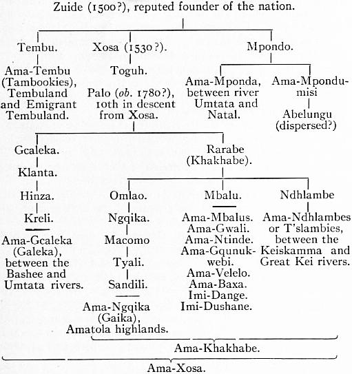
It will be seen that, as representing the elder branch, the Gcaleka stand apart from the rest of Xosa’s descendants, whom they group collectively as Ama-Rarabe (Ama-Khakhabe), and whose genealogies, except in the case of the Gaikas and T’slambies, are very confused. The Ama-Xosa country lies mainly between the Keiskama and Umtata rivers.
The Zulu call themselves Abantu ba-Kwa-Zulu, i.e. “people of Zulu’s land,” or briefly Bakwa-Zulu, from a legendary chief Zulu, founder of the royal dynasty. They were originally an obscure tribe occupying the basin of the Umfolosi river, but rose suddenly to power under Chaka,2 who had been brought up among the neighbouring and powerful Umtetwas, and who succeeded the chiefs of that tribe and of his own in the beginning of the 19th century. But the true mother tribe seems to have been the extinct Ama-Ntombela, whence the Ama-Tefulu, the U’ndwande, U’mlelas, U’mtetwas and many others, all absorbed or claiming to be true Zulus. But they are only so by political subjection, and the gradual adoption of the Zulu dress, usages and speech. Hence in most cases the term Zulu implies political rather than blood relationship. This remark applies also to the followers of Mosilikatze (properly Umsilikazi), who, after a fierce struggle with the Bechuana, founded about 1820 a second Zulu state about the head waters of the Orange river. In 1837 most of them were driven northwards by the Boers and are now known as Matabele.
The origin of the Zulu-Kaffir race has given rise to much controversy. It is obvious that they are not the aborigines of their present domain, whence in comparatively recent times—since the beginning of the 16th century—they have displaced the Hottentots and Bushmen of fundamentally distinct stock. They themselves are conscious of their foreign origin. Yet they are closely allied in speech (see Bantu Languages) and physique to the surrounding Basuto, Bechuana and other members of the great South African Negroid family. Hence their appearance in the south-east corner of the continent is sufficiently explained by the gradual onward movement of the populations pressing southward on the Hottentot and Bushman domain. The specific differences in speech and appearance by which they are distinguished from the other branches of the family must in the same way be explained by the altered conditions of their new habitat. Hence it is that the farther they have penetrated southwards the farther have they become differentiated from the pure Negro type. Thus the light and clear brown complexion prevalent amongst the southern Tembu becomes gradually darker as we proceed northwards, passing at last to the blue-black and sepia of the Ama-Swazi and Tekeza. Even many of the mixed Fingo tribes are of a polished ebony colour, like that of the Jolofs and other Senegambian negroes. The Kaffir hair is uniformly of a woolly texture. The head is dolichocephalic, but it is also high or long vertically,3 and it is in this feature of hypsistenocephaly (height and length combined) that the Kaffir presents the most striking contrast with the pure Negro. But, the nose being generally rather broad4 and the lips thick, the Kaffir face, though somewhat oval, is never regular in the European sense, the deviations being normally in the direction of the Negro, with which race the peculiar odour of the skin again connects the Kaffirs. In stature they rank next to the Patagonians, Polynesians and West Africans, averaging from 5 ft. 9 in. to 5 ft. 11 in., and even 6 ft.5 They are slim, well-proportioned and muscular. Owing to the hard life they lead, the women are generally inferior in appearance to the men, except amongst the Zulu, and especially the Tembu. Hence in the matrimonial market, while the Ama-Xosa girl realizes no more than ten or twelve head of cattle, the Tembu belle fetches as many as forty, and if especially fine even eighty.
The more warlike tribes were usually arrayed in leopard or ox skins, of late years generally replaced by European blankets, with feather head-dresses, coral and metal ornaments, bead armlets and necklaces. The Makua and a few others practise tattooing, and the Ama-Xosa are fond of painting or smearing their bodies with red ochre. Their arms consist chiefly of ox-hide shields 4 to 6 ft. long, the kerrie or club, and the assegai, of which there are two kinds, one long, with 9-in. narrow blade, for throwing, the other short, with broad blade 12 to 18 in. long, for stabbing. The dwellings are simple conical huts grouped in kraals or villages. Although cattle form their chief wealth, and hunting and stock-breeding their main pursuits, many have turned to husbandry. The Zulu raise regular crops of “mealies” (maize), and the Pondo cultivate a species of millet, tobacco, water melons, yams and other vegetables. Milk (never taken fresh), millet and maize form the staples of food, and meat is seldom eaten except in time of war.
A young Kaffir attains man’s estate socially, not at puberty, but upon his marriage. Polygyny is the rule and each wife is regarded as adding dignity to the household. Marriage is by purchase, the price being paid in cattle. Upon the husband’s death family life is continued under the headship of the eldest son of the house, the widows by virtue of levirate becoming the property of the uncle or nearest males, not sons. A son inherits and honourably liquidates, if he can, his father’s debts.
Mentally the Kaffirs are superior to the Negro. In their social and political relations they display great tact and intelligence; they are remarkably brave, warlike and hospitable, and were honest and truthful until through contact with the whites they became suspicious, revengeful and thievish, besides acquiring most European vices. Of religion as ordinarily understood they have very little, and have certainly never developed any mythologies or dogmatic systems. It is more than doubtful whether they had originally formed any notion of a Supreme Being. Some conception, however, of a future state is implied by a strongly developed worship of ancestry, and by a belief in spirits and ghosts to whom sacrifices are made. There are no idols or priests, but belief in witchcraft formerly gave the “witch-doctor” or medicine-man overwhelming power.6 Circumcision and polygyny are universal; the former is sometimes attributed to Mahommedan influences, but has really prevailed almost everywhere in East Africa from the remotest time.
Dearer than anything else to the Kaffir are his cattle; and many ceremonial observances in connexion with them were once the rule. Formerly ox-racing was a common sport, the oxen running, riderless, over a ten-mile course. The owner of a champion racing ox was a popular hero, and these racers were valued at hundreds of head of cattle. Cattle are the currency of the Kaffirs in their wild state. Ten to twenty head are the price of a wife. When a girl marries, her father (if well off) presents her with a cow from his herd. This animal is called ubulungu or “doer of good” and is regarded as sacred. It must never be killed nor may its descendants, as long as it lives. A hair of its tail is tied round the neck of each child immediately after birth. In large kraals there is the “dancing-ox,” usually of red colour. Its horns are trained to peculiar shapes by early mutilations. It figures in many ceremonies when it is paid a kind of knee-worship.
The Kaffirs have three, not four, seasons: “Green Heads,” “Kindness” and “Cutting”; the first and last referring to the crops, the second to the “warm weather.” Women and children only eat after the men are satisfied. A light beer made from sorghum is the national drink.
Of the few industries the chief are copper and iron smelting, practised by the Tembu, Zulu and Swazi, who manufacture weapons, spoons and agricultural implements both for their own use and for trade. The Swazi display some taste in wood-carving, and others prepare a peculiar water-tight vessel of grass. Characteristic of this race is their neglect of the art of navigation. Not the smallest boats are ever made for crossing the rivers, much less for venturing on the sea, except by the Makazana of Delagoa Bay and by the Zambezi people, who have canoes and flat-bottomed boats made of planks.
The Kaffir race had a distinct and apparently very old political system, which may be described as a patriarchal monarchy limited by a powerful aristocracy. Under British rule the tribal independence of the Kaffirs has disappeared. Varying degrees of autonomy have been granted, but the supreme powers of the chiefs have gone, the Swazi being in 1904 the last to be brought to order. In the Transkeian Territories tribal organization exists, but it is modified by special legislation and the natives are under the control of special magistrates. To a considerable extent in Natal and throughout Zululand the Kaffirs are placed in reserves, where tribal organization is kept up under European supervision. In Basutoland the tribal organization is very strong, and the power of chiefs is upheld by the imperial government, which exercises general supervision.
See Gustav Fritsch, Die Eingeborenen Südafrikas, with atlas, 30 plates and 120 typical heads (Breslau, 1872); W. H. I. Bleek, Comparative Grammar of the South African Languages (London and Cape Town, pt. i., 1862; pt. ii., 1869); Theo. Hahn, Grundzüge einer Grammatik des Herero (Berlin, 1857); Dr Colenso, Grammar of the Zulu-Kafir Language (1855); Girard de Rialle, Les Peuples de l’Afrique et de l’Amérique (Paris, 1880); G. W. Stow, The Native Races of South Africa (London, 1905); G. McC. Theal, History and Ethnography of South Africa, 1505 to 1795 (3 vols., London, 1907-1910) and History of South Africa since 1795 (5 vols., London, 1908), specially valuable for the political history of the Kaffirs; Caesar C. Henkel, The Native or Transkeian Territories (Hamburg, 1903); The Natives of South Africa (1901), and its sequel, The South African Natives (1908); Dudley Kidd, The Essential Kafir (1904) and Kafir Socialism. The last four books deal with the many social and economic questions raised by the contact of the Kaffir races with Europeans.
1 The Ama-Fengu are regarded both by the Zulu and Ama-Xosa as slaves or out-castes, without any right to the privileges of true-born Kaffirs. Any tribes which become broken and mixed would probably be regarded as Ama-Fengu by the other Kaffirs. Hence the multiplicity of clans, such as the Ama-Bele, Aba-Sembotweni Ama-Zizi, Ama-Kuze, Aba-Sekunene, Ama-Ntokaze, Ama-Tetyeni Aba-Shwawa, &c., all of whom are collectively grouped as Ama-Fengu.
2 Seventh in descent from Zulu, through Kumede, Makeba, Punga, Ndaba, Yama and Tezengakona or Senzangakona (Bleek, Zulu Legends).
3 P. Topinard, Anthropology (1878), p. 274.
4 This feature varies considerably, “in the T’slambie tribes being broader and more of the Negro shape than in the Gaika or Gcaleka, while among the Ama-Tembu and Ama-Mpondo it assumes more of the European character. In many of them the perfect Grecian and Roman noses are discernible” (Fleming’s Kaffraria, p. 92).
5 Gustav Fritsch gives the mean of the Ama-Xosa as 1.718 metres, less than that of the Guinea Negro (1.724), but more than the English (1.708) and Scotch (1.710).
6 Since the early years of the 19th century Protestant and Roman Catholic missions have gained hundreds of thousands of converts among the Kaffirs. Purely native Christian churches have also been organized.
KAFFRARIA, the descriptive name given to the S.E. part of the Cape province, South Africa. Kaffraria, i.e. the land of the Kaffirs (q.v.), is no longer an official designation. It used to comprise the districts now known as King William’s Town and East London, which formed British Kaffraria, annexed to Cape Colony in 1865, and the territory beyond the Kei River south of the Drakensberg Mountains as far as the Natal frontier, known as Kaffraria proper. As a geographical term it is still used to indicate the Transkeian territories of the Cape provinces comprising the four administrative divisions of Transkei, Pondoland, Tembuland and Griqualand East, incorporated into Cape Colony at various periods between 1879 and 1894. They have a total area of 18,310 sq. m., and a population (1904) of 834,644, of whom 16,777 were whites. Excluding Pondoland—not counted previously to 1904—the population had increased from 487,364 in 1891 to 631,887 in 1904.
Physical Features.—The physical characteristics of Kaffraria bear a general resemblance to those of the Cape province proper. The country rises from sea-level in a series of terraces to the rugged range of the Drakensberg. Between that range and the coast-lands are many subsidiary ranges with fertile valleys through which a large number of rivers make their way to the Indian Ocean. These rivers have very rapid falls in comparison to their length and when less than 40 m. from the coast are still 2000 ft. above sea-level. The chief, beginning at the south, are the Kei, the Bashee, the Umtata, the St John’s or Umzimvubu, and the Umtamvuna, which separates Kaffraria from Natal. The St John’s River rises in the Drakensberg near the Basuto-Natal frontier. The river valley has a length of 140 m., the river with its many twists being double that length. It receives numerous tributaries, one, the Tsitza, possessing a magnificent waterfall, the river leaping over an almost vertical precipice of 375 ft. The St John’s reaches the sea between precipitous cliffs some 1200 ft. high and covered with verdure. The mouth is obstructed by a sand bar over which there is 14 ft. of water. None of the rivers of Kaffraria except the St John’s is navigable.
Kaffraria is one of the most fertile regions in South Africa. The mountain gorges abound in fine trees, thick forest and bush cover the river banks, grass grows luxuriantly in the lower regions, and the lowlands and valleys are favourable to almost any kind of fruit, field and garden cultivation. The coast districts are very hot in summer, the temperature from October to April on an average varying from 70° to 90° F., while in winter the day temperature is seldom below 50°, though the nights are very cold. But the variation in altitude places climates of all grades within easy reach, from the burning coast to the often snow-clad mountain. Thunderstorms are frequent in summer; the winters are generally dry. On the whole the climate is extremely healthy. At St John’s are sulphur springs.
A considerable area is devoted to the raising of wheat and other cereals, especially in the northern district (Griqualand East), where in the higher valleys are many farms owned by Europeans. Large quantities of stock are raised. Most of the land is held by the natives under tribal tenure, and the ease with which their wants are supplied is detrimental to the full cultivation of the land. Kaffraria is, however, one of the chief recruiting grounds for labour throughout South Africa. Most of the white inhabitants are engaged in trade.
Towns and Communication.—The chief town is Kokstad (q.v.), pop. (1904), 2903, the capital of Griqualand East. Umtata (2100 ft. above the sea, pop. 2342) on the river of the same name, capital of Tembuland, is the residence of an assistant chief magistrate, headquarters of a division of the Cape Mounted Rifles, and seat of the Anglican bishopric of Kaffraria. The principal buildings are the cathedral, a Gothic structure, built 1901-1906, and the town-hall, a fine building in Renaissance style, erected 1907-1908. Port St John is the chief town in Pondoland, and the only harbour of the country. Butterworth is the chief town in Transkei. Cala (pop. about 1000), in the N.W. part of Tembuland, is the educational centre of Kaffraria. A railway, 107 m. long, the first link in the direct Cape-Natal line, runs from Indwe, 65 m. from Sterkstroom Junction on the main line from East London to the Transvaal, to Maclear, an agricultural centre in Griqualand East. Another railway parallel but south of that described also traverses Kaffraria. Starting from Amabele, a station on the main line from East London to the north, it goes via Butterworth (132 m. from East London) to Umtata (234 m.).
Administration and Justice.—The Cape administrative and judicial system is in force, save as modified by special enactments of the Cape parliament. A “Native Territories Penal Code” which came into operation on the 1st of January 1887 governs the relations of the natives, who are under the jurisdiction of a chief magistrate (resident at Cape Town) with subordinate magistrates in the Territories. In civil affairs the tribal organization and native laws are maintained. No chief, however, exercises criminal jurisdiction. Since 1898 certain provisions of the Glen Grey Act have been applied to Kaffraria (see Glen Grey). The revenue is included in the ordinary budget of the Cape province. The expenditure on Kaffraria considerably exceeds the revenue derived from it. The franchise laws are the same as in the Cape proper. Though the Kaffirs outnumber the whites by fifty to one, white men form the bulk of the electorate, which in 1904 numbered 4778.
Religion.—Numbers of Protestant missionary societies have churches and educational establishments in Kaffraria, but, except in Fingoland, the bulk of the Kaffirs are heathen. The Griquas profess Christianity and have their own churches and ministers. The Anglican diocese of St John’s, Kaffraria, was founded in 1873.
Annexation to the Cape.—The story of the conflicts between the Kaffir tribes and the Cape colonists is told under Cape Colony. As early as 1819 Kaffirland, or Kaffraria, was held not to extend west beyond the Keiskamma River. The region east of that river as far as the Kei River became in 1847 the Crown colony of British Kaffraria, and was annexed to Cape Colony in 1865. The Transkeian territories remained in nominal independence until 1875, when the Tembu sought British protection. An inter-tribal war in 1877 between Fingo and Gcaleka resulted in the territory of the Gcaleka chief Kreli being occupied by the British. It was not, however, till 1879 that Fingoland and the Idutywa Reserve, together with the district then commonly called Noman’s-land, were proclaimed an integral part of the Cape. About this time most of the rest of Kaffraria came under British control, but it was 1885 before Gcalekaland, the coast region of Transkei, and the various districts comprising Tembuland—Bomvanaland on the coast, Tembuland Proper and Emigrant Tembuland—were annexed to the colony. By the annexation, the frontier of the colony was carried to the Umtata River, so that by 1885 only Pondoland, fronting on the Indian Ocean, separated the Cape from Natal. In Pondoland, Port St John, proclaimed British territory in 1881, was, along with the lower reaches of the St John’s River, incorporated with Cape Colony in 1884; in 1886 the Xesibe country (Mount Ayliff) was annexed to the Cape and added to Griqualand East; and in the following year Rhode Valley was included within the boundary line. The rest of Pondoland, chiefly in virtue of a British protectorate established over all the coast region in 1885, was already more or less under British control, and in 1894 it was annexed to the Cape in its entirety. Thus the whole of Kaffraria was incorporated in Cape Colony, with the exception of some 1550 sq. m., then part of Noman’s-land, annexed by Natal in 1866 and named Alfred county. To the wise administration of Major Sir Henry G. Elliot, who served in Kaffraria in various official capacities from 1877 to 1903, the country owes much of its prosperity.
Particulars concerning each of the four divisions of Kaffraria follow.
Griqualand East (area, 7594 sq. m.), so called to distinguish it from Griqualand West, a district north of the Orange River, lies between Basutoland (N.W.), Natal (N.E.), Tembuland (S.W.) and Pondoland (S.E.). It occupies the southern slopes of the Drakensberg or the fertile valleys at their feet. It includes most of the region formerly called Noman’s-land, and afterwards named Adam Kok’s Land from the Griqua chief who occupied it in 1862 with the consent of the British authorities, and governed the country till his death in 1876, establishing a volksraad on the Dutch model. The Griquas are still ruled by an officially appointed headman. The majority of the inhabitants are Basutos and Kaffirs (Pondomisi, Ama-Baka and other tribes). The Griquas number about 6000. Since its annexation to Cape Colony Griqualand East has made fairly rapid progress. The population rose from 121,000 in 1881 to 222,685 in 1904, of whom 5901 were whites. Stock-breeding on the uplands, tillage on the lower slopes of the Drakensberg, are the chief industries. On these slopes and uplands the climate is delightful and well suited to Europeans. There is considerable trade with Basutoland in grain and stock, and through Kokstad with Port St John and Port Shepstone, Natal. Much of the best agricultural land is owned by Europeans.
Tembuland (area, 4122 sq. m.), which lies S.W. of Griqualand East and comprises the districts of Tembuland Proper, Emigrant Tembuland and Bomvanaland, takes its name from, the Tembu nation, called sometimes Tambookies, one of the most powerful of the Kaffir groups. In the national genealogies the Tembu hold an honourable position, being traditionally descended from Tembu, elder brother of Xosa, from whom most of the other Kaffirs claim descent. The inhabitants increased from about 160,000 in 1881 to 231,472 in 1904, of whom 8056 were whites. The chief town is Umtata.
Transkei (area, 2552 sq. m.) comprises the districts of Fingoland, the Idutywa Reserve and Gcalekaland, this last being named from the Gcaleka nation, who claim to be the senior branch of the Xosa family, the principal royal line of the Kaffir tribes. They still form the chief element of the population, which rose from 136,000 in 1881 to 177,730 in 1904 (1707 whites). Here are some prosperous missionary stations, where the natives are taught agriculture, mechanical industries and a knowledge of letters. The heroic deeds of Hinza, Kreli and other chiefs famous in the wars are still remembered; but witchcraft, rain-making and other pagan practices seem to have died out. Even more advanced in all social respects are the Fingo, who give their name to the district of Fingoland, and also form the bulk of the population in the Idutywa Reserve. They wear European clothes, support their schools by voluntary contributions, edit newspapers, translate English poetry, set their national songs to correct music, and the majority profess Christianity. The industrial institution of Blythswood, about 20 m. N.W. of Butterworth, is a branch of Lovedale (q.v.), and is largely supported by the Fingo.
Pondoland (area, 4040 sq. m.; pop. (1904), 202,757 (including 1113 whites), an estimated increase of 36,000 since 1891) is bounded E. by the sea, N. by Natal, W. by Griqualand East, by S. and Tembuland. In Pondoland the primitive organization of the natives has been little altered and the influence of the chiefs is very great. Land is held almost wholly in tribal tenure, though a number of whites possess farms acquired before the annexation of the country. The Pondo have shown some appreciation of the benefits of education.
See G. McCall Theal’s History of South Africa and other works cited under Cape Colony; also The Native or Transkeian Territories, by C. C. Henkel (Hamburg, 1903), a useful handbook by an ex-official in the Transkeian Territories.
KAFIRISTAN, a province of Afghanistan. Very little of this country was known with accuracy and nothing at first hand until General Sir W. (then Colonel) Lockhart headed a mission to examine the passes of the Hindu Kush range in 1885-1886. He penetrated into the upper part of the Bashgal valley, but after a few days he found himself compelled to return to Chitral. Previously Major Tanner, R.A., had sought to enter Kafiristan from Jalalabad, but sudden severe illness cut short his enterprise. M’Nair, the famous explorer of the Indian Survey department, believed that he had actually visited this little-known land during an adventurous journey which he made from India and through Chitral in disguise; but the internal evidence of his reports shows that he mistook the Kalash district of Chitral, with its debased and idolatrous population, for the true Kafiristan of his hopes. In 1889 Mr G. S. Robertson (afterwards Sir George Robertson, K.C.S.I.) was sent on a mission to Kafiristan. He only remained a few days, but a year later he revisited the country, staying amongst the Kafirs for nearly a year. Although his movements were hampered, his presence in the country being regarded with suspicion, he was able to study the people, and, in spite of intertribal jealousy, to meet members of many of the tribes. The facts observed and the information collected by him during his sojourn in eastern Kafiristan, and during short expeditions to the inner valleys, are the most trustworthy foundations of our knowledge of this interesting country.
Kafiristan, which literally means “the land of the infidel,” is the name given to a tract of country enclosed between Chitral and Afghan territory. It was formerly peopled by pagan mountaineers, who maintained a wild independence until 1895, when they were finally subdued by Abdur Rahman, the amir of Kabul, who also compelled them to accept the religion of Islam. The territory thus ill named is included between 34° 30′ and 36° N., and from about 70° to 71° 30′ E. As the western and northern boundaries are imperfectly known, its size cannot be estimated with any certainty. Its greatest extent is from east to west at 35° 10′ N.; its greatest breadth is probably about 71° E. The total area approximates to 5000 sq. m. Along the N. the boundary is the province of Badakshan, on the N.E. the Lutkho valley of Chitral. Chitral and lower Chitral enclose it to the E., and the Kunar valley on the S.E. Afghanistan proper supplies the S. limit. The ranges above the Nijrao and Pansher valleys of Afghanistan wall it in upon the W. The northern frontier is split by the narrow Minjan valley of Badakshan, which seems to rise in the very heart of Kafiristan.
Speaking generally, the country consists of an irregular series of main valleys, for the most part deep, narrow and tortuous, into which a varying number of still deeper, narrower and more twisted valleys, ravines and glens pour their torrent water. The mountain ranges of Metamorphic rock, which separate the main drainage valleys, are all of considerable altitude, rugged and difficult, with the outline of a choppy sea petrified. During the winter months, when the snow lies deep, Kafiristan becomes a number of isolated communities, with few if any means of intercommunication. In the whole land there is probably nothing in the shape of a plain. Much of the silent, gigantic country warms the heart as well as captivates the eye with its grandeur and varied beauty; much of it is the bare skeleton of the world wasted by countless centuries of storms and frost, and profoundly melancholy in its sempiternal ruin. Every variety of mountain scenery can be found: silent peaks and hard, naked ridges, snowfields and glaciers; mighty pine forests, wooded slopes and grazing grounds; or wild vine and pomegranate thickets bordering sparkling streams. At low elevations the hill-sides are covered with the wild olive and evergreen oaks. Many kinds of fruit trees—walnuts, mulberries, apricots and apples—grow near the villages or by the wayside, as well as splendid horse-chestnuts and other shade trees. Higher in elevation, and from 4000 to 8000 ft., are the dense pine and cedar forests. Above this altitude the slopes become dreary, the juniper, cedar and wild rhubarb gradually giving place to scanty willow patches, tamarisk and stunted birches. Over 13,000 ft. there are merely mosses and rough grass. Familiar wildflowers blossom at different heights. The rivers teem with fish. Immense numbers of red-legged partridges live in the lower valleys, as well as pigeons and doves. Gorgeously plumaged pheasants are plentiful. Of wild animals the chief are the markhor (a goat) and the oorial (a sheep). In the winter the former are recklessly slaughtered by hunters, being either brought to bay by trained hounds, or trapped in pits, or caught floundering in the snow-drifts; but in the summer immense herds move on the higher slopes. The ibex is very rare. Bears and leopards are fairly common, as well as the smaller hill creatures.
All the northern passes leading into Badakshan or into the Minjan valley of Badakshan seem to be over 15,000 ft. in altitude. Of these the chief are the Mandal, the Kamah (these two alone have been explored by a European traveller), the Passes and Roads. Kti, the Kulam and the Ramgal passes. Those to the east, the Chitral passes, are somewhat lower, ranging from 12,000 to 14,000 ft., e.g. the Zidig, the Shui, the Shawal and the Parpit, while the Patkun, which crosses one of the dwindled spurs near the Kunar river, is only 8400 ft. high. Between neighbouring valleys the very numerous communicating footways must rarely be lower than 10,000, while they sometimes exceed 14,000 ft. The western passes are unknown. All these toilsome paths are so faintly indicated, even when free from snow, that to adventure them without a local guide is usually unsafe. Yet the light-framed cattle of these jagged mountains can be forced over many of the worst passes. Ordinarily the herding tracks, near the crest of the ridges and high above the white torrents, are scarcely discoverable to untutored eyes. They wind and waver, rise, drop and twist about the irregular semi-precipitous slopes with baffling eccentricity and abruptness. Nevertheless the cattle nose their way along blunderingly, but without hurt. Of no less importance in the open months, and the sole trade routes during winter, are the lower paths by the river. An unguided traveller is continually at fault upon these main lines of intercourse and traffic.
All the rivers find their tumultuous way into the Kabul, either directly, as the Alingar at Laghman, or after commingling with the Kunar at Arundu and at Chigar-Serai. The Bashgal, draining the eastern portion of the country, empties Rivers. itself into the Kunar at Arundu. It draws its highest waters from three main sources at the head of the Bashgal valley. It glides gently through a lake close to this origin, and then through a smaller tarn. The first affluent of importance is the Skorigal, which joins it above the village of Pshui. Next comes the noisier Manangal water, from the Shawal pass, which enters the main stream at Lutdeh or Bragamatal, the chief settlement of the Bashgal branch of the Katir tribe. By-and-by the main stream becomes, at the hamlet of Sunra, a raging, shrieking torrent in a dark narrow valley, its run obstructed by giant boulders and great tree-trunks. Racing past Bagalgrom, the chief village of the Madugal Kafirs, the river clamours round the great spur which, 1800 ft. higher up, gives space for the terraces and houses of Kamdesh, the headquarters of the Kam people. The next important affluent is the river which drains the Pittigal valley, its passes and branches. Also on the left bank, and still lower down, is the joining-place of the Gourdesh valley waters. Finally it ends in the Kunar just above Arundu and Birkot. The middle part of Kafiristan, including the valleys occupied by the Presun, Kti, Ashkun and Wai tribes, is drained by a river variously called the Pech, the Kamah, and the Presun or Viron River. It has been only partially explored. Fed by the fountains and snows of the upper Presun valley, it is joined at the village of Shtevgrom by the torrent from the Kamah pass. Thence it moves quietly past meadowland, formerly set apart as holy ground, watering on its way all the Presun villages. Below the last of them, with an abrupt bend, it hurries into the unexplored and rockbound Tsaru country, where it absorbs on the right hand the Kti and the Ashkun and on the left the Wai rivers, finally losing itself in the Kunar, close to Chigar-Serai. Concerning the Alingar or Kao, which carries the drainage of western Kafiristan into the Kabul at Laghman, there are no trustworthy details. It is formed from the waters of all the valleys inhabited by the Ramgal Kafirs, and by that small branch of the Katirs known as the Kalam tribe.
The climate varies with the altitude, but in the summer-time it is hot at all elevations. In the higher valleys the winter is rigorous. Snow falls heavily everywhere over 4000 ft. above the sea-level. During the winter of 1890-1891 at Kamdesh Climate. (elevation 6100 ft.) the thermometer never fell below 17° F. In many of the valleys the absence of wind is remarkable. Consequently a great deal of cold can be borne without discomfort. The Kunar valley, which is wet and windy in winter, but where snow, if it falls, melts quickly, gives a much greater sensation of cold than the still Kafiristan valleys of much lower actual temperature. A deficiency of rain necessitates the employment of a somewhat elaborate system of irrigation, which in its turn is dependent upon the snowfall.
The present inhabitants are probably mainly descended from the broken tribes of eastern Afghanistan, who, refusing to accept Islam (in the 10th century), were driven away by the fervid swordsmen of Mahomet. Descending upon The Kafirs. the feeble inhabitants of the trackless slopes and perilous valleys of modern Kafiristan, themselves, most likely, refugees of an earlier date, they subjugated and enslaved them and partially amalgamated with them. These ancient peoples seem to be represented by the Presun tribe, by the slaves and by fragments of lost peoples, now known as the Jazhis and the Aroms. The old division of the tribes into the Siah-Posh, or the black-robed Kafirs, and the Safed-Posh, or the white-robed, was neither scientific nor convenient, for while the Siah-Posh have much in common in dress, language, customs and appearance, the Safed-Posh divisions were not more dissimilar from the Siah-Posh than they were from one another. Perhaps the best division at present possible is into (1) Siah-Posh, (2) Waigulis, and (3) Presungalis or Viron folk.
The black-robed Kafirs consist of one very large, widely spread tribe, the Katirs, and four much smaller communities, the Kam, the Madugalis, the Kashtan or Kashtoz, and the Gourdesh. Numerically, it is probable that the Katirs The Siah-Posh. are more important than all the remaining tribes put together. They inhabit several valleys, each community being independent of the others, but all acknowledging the same origin and a general relationship. The Katirs fall readily into the following groups: (a) Those of the Bashgal valley, also called Kamoz and Lutdehchis, who occupy eleven villages between Badawan and Sunra, the border hamlet of the Madugal country, namely, Ptsigrom, Pshui or Pshowar, Apsai, Shidgal, Bragamatal (Lutdeh), Bajindra, Badamuk, Oulagal, Chabu, Baprok and Purstam; (b) the Kti or Katwar Kafirs, who live in two settlements in the Kti valley; (c) the Kulam people, who have four villages in the valley of the same name; (d) the Ramgalis, or Gabariks, who are the most numerous, and possess the western part on the Afghan border. Of the remaining tribes of the Siah-Posh, the chief is the Kam or Kamtoz, who inhabit the Bashgal valley, from the Madugal boundary to the Kunar valley, and its lateral branches in seven chief settlements, namely, Urmir, Kambrom or Kamdesh, Mergrom, Kamu, Sarat, Pittigal and Bazgal. The next Siah-Posh tribe in importance is the Muman or Madugal Kafirs, who have three villages in the short tract between the Katirs and the Kam in the Bashgal valley. The last Siah-Posh tribe is the Kashtan or Kashtoz, who in 1891 were all located in one greatly overcrowded village, their outlying settlement having been plundered by the Afghan tribes of the Kunar valley. One colony of Siah-Posh Kafirs lives in the Gourdesh valley; but they differ from all the other tribes, and are believed to be descended, in great part, from the ancient people called the Aroms.
Our exact knowledge of the Waigulis is scanty. They seem to be related in language and origin with a people fierce, shy and isolated, The Waigulis. called the Ashkun, who are quite unknown. The Wai speak a tongue altogether different from that spoken by the Siah-Posh and by the Presungalis. The names of their ten chief villages are Runchi, Nishi, Jamma, Amzhi, Chimion, Kegili, Akun or Akum, Mildesh, Bargal and Prainta. Of these Amzhi and Nishi are the best known.
The Presungalis, also called Viron, live in a high valley. In all respects they differ from other Kafirs, in none more than in their The Presungalis. unwarlike disposition. Simple, timid, stolid-featured and rather clumsy, they are remarkable for their industry and powers of endurance. They probably represent some of the earliest immigrants. Six large well-built villages are occupied by them—Shtevgrom, Pontzgrom, Diogrom, Kstigigrom, Satsumgrom and Paskigrom.
The slaves are fairly numerous. Their origin is probably partly from the very ancient inhabitants and partly from war prisoners. Coarse in feature and dark in tint, they cannot be The Slaves. distinguished from the lowest class of freemen, while their dress is indistinctive. They are of two classes—household slaves, who are treated not unkindly; and artisan slaves, who are the skilled handicraftsmen—carvers, blacksmiths, bootmakers and so forth; many of the musicians are also slaves. They live in a particular portion of a village, and were considered to a certain extent unclean, and might not approach closely to certain sacred spots. All slaves seem to wear the Siah-Posh dress, even when they own as masters the feeble Presungal folk.
Little respect is shown to women, except in particular cases to a few of advanced years. Usually they are mistresses and slaves, saleable chattels and field-workers. Degraded, immoral, overworked and carelessly fed, they are also, as a rule, Women. unpleasant to the sight. Little girls are sometimes quite beautiful, but rough usage and exposure to all weathers soon make their complexions coarse and dark. They are invariably dirty and uncombed. In comparison with the men they are somewhat short. Physically they are capable of enormous labour, and are very enduring. All the field-work falls to them, as well as all kinds of inferior occupations, such as load-carrying. They have no rights as against their husbands or, failing them, their male relations. They cannot inherit or possess property.
There are certainly three tongues spoken, besides many dialects, that used by the Siah-Posh being of course the most common; and although it has many dialects, the employers of one seem to understand all the others. It is a Prakritic language. Language. Of the remaining two, the Wai and the Presun have no similarity; they are also unlike the Siah-Posh. Kafirs themselves maintain that very young children from any valley can acquire the Wai speech, but that only those born in the Presungal can ever converse in that language, even roughly. To European ears it is disconcertingly difficult, and it is perhaps impossible to learn.
Before their conquest by Abdur Rahman all the Kafirs were idolaters of a rather low type. There were lingering traces of ancestor-worship, and perhaps of fire-worship also. The gods were numerous; tribal, family, household deities Religion. had to be propitiated, and mischievous spirits and fairies haunted forests, rivers, vales and great stones. Imra was the Creator, and all the other supernatural powers were subordinate to him. Of the inferior gods, Moni seemed to be the most ancient; but Gísh, the war-god, was by far the most popular. It was his worship, doubtless, which kept the Kafirs so long independent. In life as a hero, and after death as a god, he symbolized hatred to the religion of Mahomet. Every village revered his shrine; some possessed two. Imra, Gísh and Moni were honoured with separate little temples, as was usually Dizáni goddess; but three or four of the others would share one between them, each looking out of a small separate square window. The worshipped object was either a large fragment of stone or an image of wood conventionally carved, with round white stones for eyes. Different animals were sacrificed at different shrines: cows to Imra, male goats and bulls to Gísh, sheep to the god of wealth; but goats were generally acceptable, and were also slain ceremonially to discover a complaisant god, to solemnize a vow, to end a quarrel, to ratify brotherhood. The ministers of religion were a hereditary priest, a well-born chanter of praise, and a buffoon of low station, who was supposed to become inspired at each sacrifice, and to have the power of seeing fairies and other spirits whenever they were near, also of understanding their wishes. The blood of the offering, together with flour, wine and butter, was cast on the shrine after the animal and the other gifts had been sanctified with water sprinkled by the officiating priests, while he cried “Súch, súch!” (“Be pure!”). Dense clouds of smoke from burning juniper-cedar, which crackled and gave forth pungent incense, added to the spectacle, which was dignified by the bearing of the officials and solemnized by the devout responses of the congregation. There was no human sacrifice except when a prisoner of war, after a solemn service at a shrine, was taken away and stabbed before the wooden tomb of some unavenged headman. Kafirs believed in a kind of Hell where wicked people burned; but the Hereafter was an underground region entered by a guarded aperture, and inhabited by the shapes which men see in dreams. Suicide was as unknown as fear of dying. Melancholy afflicted only the sick and the bereaved. Religious traditions, miracles and anecdotes were puerile, and pointed no social lesson or any religious law. Music, dancing and songs of praise were acceptable to the gods, and every village (grom) had its dancing platform and dancing house (grom ma), furnished with a simple altar. No prayers were offered, only invocations, exhortative or remonstrant.
The great majority of the tribes were made up of clans. A person’s importance was derived chiefly from the wealth of his family and the number of male adults which it contained. The power of a family, as shown by the number and Tribal Organization. quality of its fighting men as well as by the strength of its followers, was the index of that family’s influence. Weak clans and detached families, or poor but free households, carried their independence modestly. The lowest clan above the slaves sought service with their wealthier tribesmen as henchmen and armed shepherds. By intricate ceremonial, associated with complicated duties, social and religious, which extended over two years, punctuated at intervals by prodigious compulsory banquets, rich men could become elders or jast. Still further outlay and ostentation enabled the few who could sustain the cost to rank still higher as chief or Mír. Theoretically, all the important and outside affairs of the tribe were managed by the jast in council; actually they were controlled by two or three of the most respected of that class. Very serious questions which inflamed the minds of the people would be debated in informal parliaments of the whole tribe. Kafirs have a remarkable fondness for discussing in conclave. Orators, consequently, are influential. The internal business of a tribe was managed by an elected magistrate with twelve assistants. It was their duty to see that the customs of the people were respected; that the proper seasons for gathering fruit were rigidly observed. They regulated the irrigation of the fields, moderating the incessant quarrels which originated in the competition for the water; and they kept the channels in good repair. Their chief, helped by contributions in kind from all householders, entertained tribal guests. He also saw that the weekly Kafir Sabbath, from the sowing to the carrying of the crops, was carefully observed, the fires kept burning, and the dancers collected and encouraged. Opposition to these annual magistrates or infraction of tribal laws was punished by fines, which were the perquisites and the payment of those officials. Serious offences against the whole people were judged by the community itself; the sentences ranged as high as expulsion from the settlement, accompanied with the burning of the culprit’s house and the spoliation of his goods. In such cases, the family and the clan refusing to intervene, the offender at once became cowed into submission.
Habitations are generally strong, and built largely of wood. They are frequently two or more storeys high, often with an open gallery at the top. Wealthy owners were fond of elaborate carving in simple designs and devices. A room is square, with a smoke-hole Houses and Villages. when possible; small windows, with shutters and bolts, and heavy doors fastened by a sliding wooden pin, are common. The nature of the ground, its defensible character, the necessity of not encroaching upon the scanty arable land, and such considerations, determine the design of the villages. Specimens of many varieties may be discovered. There is the shockingly overcrowded oblong kind, fort-shaped, three storeys high, and on a river’s bank, which is pierced by an underground way leading to the water. Here all rooms look on to the large central courtyard; outwards are few or no windows. There is also the tiny hamlet of a few piled-up hovels perched on the flattish top of some huge rock, inaccessible when the ladder connecting it with the neighbouring hill-side or leading to the ground is withdrawn. Some villages on mounds are defended at the base by a circular wall strengthened with an entanglement of branches. Others cling to the knife-edged back of some difficult spur. Many are hidden away up side ravines. A few boldly rely upon the numbers of their fighting men, and are unprotected save by watch-towers. While frequently very picturesque at a distance, all are dirty and grimed with smoke; bones and horns of slaughtered animals litter the ground. The ground floor of a house is usually a winter stable for cows and the latrine, as well as the manure store for the household; the middle part contains the family treasures; on the top is the living-place. In cold valleys, such as the Presungal, the houses are often clustered upon a hillock, and penetrate into the soil to the depth of two or more apartments. Notched poles are the universal ladders and stairways.
In height Kafirs average about 5 ft. 6 in. They are lean; always in hard condition; active jumpers, untiring walkers, expert mountaineers; exceptionally they are tall and heavy. With chests fairly deep, and muscular, springy legs, there is Characteristics. some lightness and want of power about the shoulder muscles, the arms and the hand-grasp. In complexion they are purely Eastern. Some tribes, notably the Wai, are fairer than others, but the average colour is that of the natives of the Punjab. Albinos, or red-haired people, number less than ½% of the population. As a rule, the features are well-shaped, especially the nose. The glance is wild and bold, with the wide-lidded, restless gaze of the hawk; or the exact converse—a shifty, furtive peer under lowered brows. This look is rather common amongst the wealthier families and the most famous tribesmen. The shape of a man’s head not uncommonly indicates his social rank. Several have the brows of thinkers and men of affairs. The degraded forms are the bird-of-prey type—low, hairy foreheads, hooked noses with receding chin, or the thickened, coarse features of the darker slave class. Intellectually they are of good average power. Their moral characteristics are passionate covetousness, and jealousy so intense that it smothers prudence. Before finally destroying, it constantly endangered their wildly cherished independence. Revenge, especially on neighbouring Kafirs, is obtained at any price. Kafirs are subtle, crafty, quick in danger and resolute, as might be expected of people who have been plunderers and assassins for centuries, whose lives were the forfeit of a fault in unflinchingness or of a moment’s vacillation. Stealthy daring, born of wary and healthy nerves and the training of generations, almost transformed into an instinct, is the national characteristic. Ghastly shadows, they flitted in the precincts of hostile villages far distant from their own valleys, living upon the poorest food carried in a fetid goatskin bag; ever ready to stab in the darkness or to wriggle through apertures, to slay as they slept men, women and babies. Then, with clothing for prize, and human ears as a trophy, they sped, watchful as hares, for their far-away hills, avenger Pathans racing furiously in their track. Kafirs, most faithful to one another, never abandoned a comrade. If he were killed, they sought to carry away his head for funeral observances. As traders, though cunning enough, they are no match for the Afghan. They were more successful as brigands and blackmailers than as skilled thieves. In night robbery and in pilfering they showed little ingenuity. Truth was considered innately dangerous; but a Kafir is far more trustworthy than his Mahommedan neighbours. Although hospitality is generally viewed as a hopeful investment, it can be calculated on, and is unstinted. Kafirs are capable of strong friendship. They are not cruel, being kind to children and to animals, and protective to the weak and the old. Family ties and the claim of blood even triumph over jealousy and covetousness.
The national attire of the men is a badly-cured goatskin, confined at the waist by a leather belt studded with nails, supporting the I-hilted dagger, strong but clumsy, of slave manufacture, sheathed in wood covered with iron or brass, and often Dress, Weapons, Utensils, &c. prettily ornamented. Women are dressed in a long, very dark tunic of wool, ample below the shoulders, and edged with red. This is fastened at the bosom by an iron pin, a thorn, or a fibula; it is gathered round the body by a woven band, an inch wide, knotted in front to dangle down in tassels. On this girdle is carried a fantastically handled knife in a leather covering. The woman’s tunic is sometimes worn by men. As worn by women its shape is something between a long frock-coat and an Inverness cape. Its hue and the blackness of the hairy goatskin give the name of Siah-Posh, “black-robed,” to the majority of the clans. The other tribes wear such articles of cotton attire as they can obtain by barter, by theft, or by killing beyond the border, for only woollen cloth is made in the country. Of late years long robes from Chitral and Badakshan have been imported by the wealthy, as well as the material for loose cotton trousers and wide shirts. Clothing, always hard to obtain, is precious property. Formerly little girls, the children of slaves, or else poor relations, used to be sold in exchange for clothes and ammunition. Mahommedans eagerly bought the children, which enabled them in one transaction to acquire a female slave and to convert an infidel. Men go bareheaded, which wrinkles them prematurely, or they wear Chitral caps. Certain priests, and others of like degree, wind a strip of cotton cloth round their brows. Siah-Posh women wear curious horned caps or a small square white head-dress upon informal occasions. Females of other tribes bind their heads with turbans ornamented with shells and other finery. Excellent snow gaiters are made of goat’s hair for both sexes, and of woollen material for women. Boots, strongly sewn, of soft red leather cannot be used in the snow or when it is wet, because they are imperfectly tanned. For the ceremonial dances all manner of gay-coloured articles of attire, made of cheap silk, cotton velvet, and sham cloth-of-gold, are displayed, and false jewelry and tawdry ornaments; but they are not manufactured in the country, but brought from Peshawar by pedlars. Woollen blankets and goat’s-hair mats cover the bedsteads—four-legged wooden frames laced across with string or leather thongs. Low square stools, 18 in. broad, made upon the same principle as the bedsteads, are peculiar to the Kafirs and their half-breed neighbours of the border. Iron tripod tables, singularly Greek in design, are fashioned in Waigul. A warrior’s weapons are a matchlock (rarely a flintlock), a bow and arrows, a spear and the dagger which he never puts aside day or night. The axes, often carried, are light and weak, and chiefly indicate rank. Clubs, carefully ornamented by carving, are of little use in a quarrel; their purpose is that of a walking-stick. As they are somewhat long, these walking-clubs have been often supposed to be leaping-poles. Swords are rarely seen, and shields, carried purely for ostentation, seldom. Soft stone is quarried to make large utensils, and great grim chests of wood become grain boxes or coffins indifferently. Prettily carved bowls with handles, or with dummy spouts, hold milk, butter, water or small quantities of flour. Wine, grain, everything else, is stored or carried in goatskin bags. Musical instruments are represented by reed flageolets, small drums, primitive fiddles, and a kind of harp.
Isolated and at the outskirts of every village is a house used by women when menstruating and for lying-in. Children are named as soon as born. The infant is given to the mother to suckle, while a wise woman rapidly recites the family Peculiar Customs. ancestral names; the name pronounced at the instant the baby begins to feed is that by which it is thereafter known. Everybody has a double name, the father’s being prefixed to that given at birth. Very often the two are the same. There is a special day for the first head-shaving. No hair is allowed on a male’s scalp, except from a 4-in. circle at the back of the head, whence long locks hang down straight. Puberty is attained ceremoniously by boys. Girls simply change a fillet for a cotton cap when nature proclaims womanhood. Marriage is merely the purchase of a wife through intermediaries, accompanied by feasting. Divorce is often merely a sale or the sending away of a wife to slave for her parents in shame. Sexual morality is low. Public opinion applauds gallantry, and looks upon adultery as hospitality, provided it is not discovered by the husband. If found out, in flagrante delicto, there is a fiscal fine in cows. There is much collusion to get this penalty paid in poor households. Funeral rites are most elaborate, according to the rank and warrior fame of the deceased, if a male, and to the wealth and standing of the family, if a woman. Children are simply carried to the cemetery in a blanket, followed by a string of women lamenting. A really great man is mourned over for days with orations, dancing, wine-drinking and food distribution. Gun-firing gives notice of the procession. After two or three days the corpse is placed in the coffin at a secluded spot, and the observances are continued with a straw figure lashed upon a bed, to be danced about, lamented over, and harangued as before. During regular intervals for business and refreshment old women wail genealogies. A year later, with somewhat similar ritual, a wooden statue is inaugurated preliminary to erection on the roadside or in the village Valhalla. The dead are not buried, but deposited in great boxes collected in an assigned place. Finery is placed with the body, as well as vessels holding water and food. Several corpses may be heaped in one receptacle, which is, rarely, ornamented with flags; its lid is kept from warping by heavy stones. The wooden statues or effigies are at times sacrificed to when there is sickness, and at one of the many annual festivals food is set before them. Among the Presungal there are none of these images. Blood-feuds within a tribe do not exist. The slayer of his fellow, even by accident, has to pay a heavy compensation or else become an outcast. Several hamlets and at least one village are peopled by families who had thus been driven forth from the community. The stigma attaches itself to children and their marriage connexions. Its outward symbol is an inability to look in the face any of the dead person’s family. This avoidance is ceremonial. In private and after dark all may be good friends after a decorous interval. The compensation is seldom paid, although payment carries with it much enhancement of family dignity. All the laws to punish theft, assault, adultery and other injury are based on a system of compensation whenever possible, and of enlisting the whole of the community in all acts of punishment. Kafirs have true conceptions of justice. There is no death penalty; a fighting male is too valuable a property of the whole tribe to be so wasted. War begins honourably with proper notice, as a rule, but the murder of an unsuspecting traveller may be the first intimation. Bullets or arrow-heads sent to a tribe or village is the correct announcement of hostilities. The slaying of a tribesman need not in all cases cause a war. Sometimes it may be avoided by the sinning tribe handing over a male to be killed by the injured relations. Ambush, early morning attacks by large numbers, and stealthy killing parties of two or three are the favourite tactics. Peace is made by the sacrifice of cows handed over by the weaker tribe to be offered up to a special god of the stronger. When both sides have shown equal force and address, the same number of animals are exchanged. Field-work falls exclusively to the women. It is poor. The ploughs are light and very shallow. A woman, who only looks as if she were yoked with the ox, keeps the beast in the furrows, while a second holds the handle. All the operations of agriculture are done primitively. Grazing and dairy-farming are the real trade of the Kafirs, the surplus produce being exchanged on the frontier or sold for Kabul rupees. Herders watch their charges fully armed against marauders.
History.—The history of Kafiristan has always been of the floating legendary sort. At the present day there are men living in Chitral and on other parts of the Kafiristan frontier who are prepared to testify as eye-witnesses to marvels observed, and also heard, by them, not only in the more remote valleys but even in the Afghan borderland itself. It is not surprising therefore that the earlier records are to a great extent fairy tales of a more or less imaginative kind and chiefly of value to those interested in folk-lore. Sir Henry Yule, a scientific soldier, a profound geographer and a careful student, as the result of his researches thought that the present Kafiristan was part of that pagan country stretching between Kashmir and Kabul which medieval Asiatics referred to vaguely as Bilaur, a name to be found in Marco Polo as Bolor. The first distinct mention of the Kafirs as a separate people appears in the history of Timur. On his march to the invasion of India the people at Andarab appealed to Timur for help against the Kator and the Siah-Posh Kafirs. He responded and entered the country of those tribes through the upper part of the Panjhir valley. It was in deep winter weather and Timur had to be let down the snows by glissade in a basket guided by ropes. A detachment of 10,000 horse which he speaks of as having been sent against the Siah-Posh to his left, presumably therefore to the north, met with disaster; but he himself claims to have been victorious. Nevertheless he seems quickly to have evacuated the impracticable mountain land, quitting the country at Khawak. He caused an inscription to be carved in the defiles of Kator to commemorate his invasion and to explain its route. Inside the Kafir country on the Najil or Alishang River there is a fort still called Timur’s Castle, and in the Kalam fort there is said to be a stone engraved to record that as the farthest point of his advance. In the Memoirs of Baber there is mention of the Kafirs raiding into Panjhir and of their taste for drinking, every man having a leathern wine-bottle slung round his neck. The Ain-i-Akbari makes occasional mention of the Kafirs, probably on the authority of the famous Memoirs; it also contains a passage which may possibly have originated the widespread story that the Kafirs were descendants of the Greeks. Yule however believed that this passage did not refer to the Kafirs at all, but to the claims to descent from Alexander of the rulers in Swat before the time of the Yusufzai. Many of the princelings of the little Hindu-Kush states at the present day pride themselves on a similar origin, maintaining the founders of their race to be Alexander, “the two-horned,” and a princess sent down miraculously from heaven to wed him.
Benedict Goes, travelling from Peshawar to Kabul in 1603, heard of a place called Capperstam, where no Mahommedan might enter on pain of death. Hindu traders were allowed to visit the country, but not the temples. Benedict Goes tasted the Kafir wine, and from all that he heard suspected that the Kafirs might be Christians. Nothing more is heard of the Kafirs until 1788, when Rennell’s Memoir of a Map of Hindostan was published. Twenty-six years later Elphinstone’s Caubal was published. During the British occupation of Kabul in 1839-1840 a deputation of Kafirs journeyed there to invite a visit to their country from the Christians whom they assumed to be their kindred. But the Afghans grew furiously jealous, and the deputation was sent coldly away.