VOLUME V SLICE II Camorra to Cape Colony (continued 10)
Reading edition
CANTON (borrowed from the Ital. cantone, a corner or angle), a word used for certain divisions of some European countries. In France, the canton, which is a subdivision of the arrondissement, is a territorial, rather than an administrative, unit. The canton, of which there are 2908, generally comprises, on an average, about twelve communes, though very large communes are sometimes divided into several cantons. It is the seat of a justice of the peace, and returns a member to the conseil d’arrondissement (see France). In Switzerland, canton is the name given to each of the twenty-two states comprising the Swiss confederation (see Switzerland).
In heraldry, a “canton” is a corner or square division on a shield, occupying the upper corner (usually the dexter). It is in area two-thirds of the quarter (see Heraldry).
CANTONMENT (Fr. cantonnement, from cantonner, to quarter; Ger. Ortsunterkunft or Quartier). When troops are distributed in small parties amongst the houses of a town or village, they are said to be in cantonments, which are also called quarters or billets. Formerly this method of providing soldiers with shelter was rarely employed on active service, though the normal method in “winter quarters,” or at seasons when active military operations were not in progress. In the field, armies lived as a rule in camp (q.v.), and when the provision of canvas shelter was impossible in bivouac. At the present time, however, it is unusual, in Europe at any rate, for troops on active service to hamper themselves with the enormous trains of tent wagons that would be required, and cantonments or bivouacs, or a combination of the two have therefore taken the place, in modern warfare, of the old long rectilinear lines of tents that marked the resting-place and generally, too, the order of battle of an 18th-century army. The greater part of an army operating in Europe at the present day is accommodated in widespread cantonments, an army corps occupying the villages and farms found within an area of 4 m. by 5 or 6. This allowance of space has been ascertained by experience to be sufficient, not only for comfort, but also for subsistence for one day, provided that the density of the ordinary civil population is not less than 200 persons to the square mile. Under modern conditions there is little danger from such a dissemination of the forces, as each fraction of each army corps is within less than two hours’ march of its concentration post. If the troops halt for several days, of course they require either a more densely populated country from which to requisition supplies, or a wider area of cantonments. The difficulty of controlling the troops, when scattered in private houses in parties of six or seven, is the principal objection to this system of cantonments. But since Napoleon introduced the “war of masses” the only alternative to cantoning the troops is bivouacking, which if prolonged for several nights is more injurious to the well-being of the troops than the slight relaxation of discipline necessitated by the cantonment system, when the latter is well arranged and policed. The troops nearest the enemy, however, which have to be maintained in a state of constant readiness for battle, cannot as a rule afford the time either for dispersing into quarters or for rallying on an alarm, and in western Europe at any rate they are required to bivouac. In India, the term “cantonment” means more generally a military station or standing camp. The troops live, not in private houses, but in barracks, huts, forts or occasionally camps. The large cantonments are situated in the neighbourhood of the North-Western frontier, of the large cities and of the capitals of important native states. Under Lord Kitchener’s redistribution of the Indian army in 1903, the chief cantonments are Rawalpindi, Quetta, Peshawar, Kohat, Bannu, Nowshera, Sialkot, Mian Mir, Umballa, Muttra, Ferozepore, Meerut, Lucknow, Mhow, Jubbulpore, Bolarum, Poona, Secunderabad and Bangalore.
CANTÙ, CESARE (1804-1895), Italian historian, was born at Brivio in Lombardy and began his career as a teacher. His first literary essay (1828) was a romantic poem entitled Algiso, o la Lega Lombarda (new ed., Milan, 1876), and in the following year he produced a Storia di Como in two volumes (Como, 1829). The death of his father then left him in charge of a large family, and he worked very hard both as a teacher and a writer to provide for them. His prodigious literary activity led to his falling under the suspicions of the Austrian police, and he was mixed up in a political trial and arrested in 1833. While in prison writing materials were denied him, but he managed to write on rags with a tooth-pick and candle smoke, and thus composed the novel Margherita Pusterla (Milan, 1838). On his release a year later, as he was interdicted from teaching, literature became his only resource. In 1836 the Turinese publisher, Giuseppe Pomba, commissioned him to write a universal history, which his vast reading enabled him to do. In six years the work was completed in seventy-two volumes, and immediately achieved a general popularity; the publisher made a fortune out of it, and Cantù’s royalties amounted, it is said, to 300,000 lire (£12.000). Just before the revolution of 1848, being warned that he would be arrested, he fled to Turin, but after the “Five Days” he returned to Milan and edited a paper called La Guardia Nazionale. Between 1849 and 1850 he published his Storia degli Italiani (Turin, 1855) and many other works. In 1857 the archduke Maximilian tried to conciliate the Milanese by the promise of a constitution, and Cantù was one of the few Liberals who accepted the olive branch, and went about in company with the archduke. This act was regarded as treason and caused Cantù much annoyance in after years. He continued his literary activity after the formation of the Italian kingdom, producing volume after volume until his death. For a short time he was member of the Italian parliament; he founded the Lombard historical society, and was appointed superintendent of the Lombard archives. He died in March 1895. His views are coloured by strong religious and political prejudice, and by a moralizing tendency, and his historical work has little critical value and is for the most part pure book-making, although he collected a vast amount of material which has been of use to other writers. In dealing with modern Italian history he is reactionary and often wilfully inaccurate. Besides the above-mentioned works he wrote Gli Eretici in Italia (Milan, 1873); Cronistoria dell’ Indipendenza italiana (Naples, 1872-1877); II Conciliatore e i Carbonari (Milan, 1878), &c.
(L. V.*)
CANUSIUM (Gr. Κανύσιον, mod. Canosa), an ancient city of Apulia, on the right bank of the Aufidus (Ofanto), about 12 m. from its mouth, and situated upon the Via Traiana, 85 m. E.N.E. of Beneventum. It was said to have been founded by Diomede, and even at the time of Horace (Sat. i. 10. 30) both Greek and Latin were spoken there. The legends on the coins are Greek, and a very large number of Greek vases have been found in the necropolis. The town came voluntarily under Roman sovereignty in 318 b.c., afforded a refuge to the Roman fugitives after Cannae, and remained faithful for the rest of the war. It revolted in the Social War, in which it would appear to have suffered, inasmuch as Strabo (vi. 283) speaks of Canusium and Arpi as having been, to judge from the extent of their walls, the greatest towns in the plain of Apulia, but as having shrunk considerably in his day. Its importance was maintained, however, by its trade in agricultural products and in Apulian wool (which was there dyed and cleaned), by its port (probably Cannae) at the mouth of the Aufidus, and by its position on the high-road. It was a municipium under the early empire, but was converted into a colonia under Antoninus Pius by Herodes Atticus, who provided it with a water-supply. In the 6th century it was still the most important city of Apulia. Among the ancient buildings which are still preserved, an amphitheatre, an aqueduct and a city gate may be mentioned.
See N. Jacobone, Ricerche sulla storia e la topografia di Canosa Antica (Canosa di Puglia, 1905).
(T. As.)
CANUTE (Cnut), known as “the Great” (c. 995-1035), king of Denmark and England, second son of King Sweyn Forkbeard and his first wife, the daughter of the Polish prince, Mieszko, was born c. 995. On the death of his father he was compelled to quit England by a general rising of the Anglo-Saxons, on which occasion in a fit of rage, for he was not naturally cruel, he abandoned his hostages after cutting off their hands, ears and noses. In the following year, 1015, he returned with a great fleet manned by a picked host, “not a thrall or a freedman among them.” He speedily succeeded in subduing all England except London, now the last refuge of King Æthelred and his heroic son, Edmund Ironside. On the death of Æthelred (23rd of April 1016) Canute was elected king by an assembly of notables at Southampton; but London clung loyally to Edmund, who more than once succeeded in raising the western shires against Canute. Edmund indeed approved himself the better general of the two, and would doubtless have prevailed, but for the treachery of his own ealdormen. This was notably the case at the great battle of Assandun, in which by the desertion of Eadric an incipient Anglo-Saxon victory was converted into a crushing defeat. Nevertheless, the antagonists were so evenly matched that the great men on both sides, fearing that the interminable war would utterly ruin the land, arranged a conference between Canute and Edmund on an island in the Severn, when they agreed to divide England between them, Canute retaining Mercia and the north, while Edmund’s territory comprised East Anglia and Wessex with London. On the death of Edmund, a few months later (November 1016), Canute was unanimously elected king of all England at the beginning of 1017. The young monarch at once showed himself equal to his responsibilities. He did his utmost to deserve the confidence of his Anglo-Saxon subjects, and the eighteen years of his reign were of unspeakable benefit to his adopted country. He identified himself with the past history of England and its native dynasty by wedding Emma, or Ælgifu, to give her her Saxon name (the Northmen called her Alfifa), who came over from Normandy at his bidding, Canute previously repudiating his first wife, another Ælgifu, the daughter of the ealdorman Aelfhem of Deira, who, with her sons, was banished to Denmark. In 1018 Canute inherited the Danish throne, his elder brother Harold having died without issue. He now withdrew most of his army from England, so as to spare as much as possible the susceptibilities of the Anglo-Saxons. For the same reason he had previously dispersed all his warships but forty. On his return from Denmark he went a step farther. In a remarkable letter, addressed to the prelates, ealdormen and people, he declared his intention of ruling England by the English, and of upholding the laws of King Edgar, at the same time threatening with his vengeance all those who did not judge righteous judgment or who let malefactors go free. The tone of this document, which is not merely Christian but sacerdotal, shows that he had wisely resolved, in the interests of law and order, to form a close alliance with the native clergy. Those of his own fellow-countrymen who refused to co-operate with him were summarily dismissed. Thus, in 1021, the stiffnecked jarl Thorkil was banished the land, and his place taken by an Anglo-Saxon, the subsequently famous Godwin, who became one of Canute’s chief counsellors. The humane and conciliatory character of his government is also shown in his earnest efforts to atone for Danish barbarities in the past. Thus he rebuilt the church of St Edmundsbury in memory of the saintly king who had perished there at the hands of the earlier Vikings, and with great ceremony transferred the relics of St Alphege from St Paul’s church at London to a worthier resting-place at Canterbury. His work of reform and reconciliation was interrupted in 1026 by the attempt of Olaf Haraldson, king of Norway, in conjunction with Anund Jakob, king of Sweden, to conquer Denmark. Canute defeated the Swedish fleet at Stangebjerg, and so seriously injured the combined squadrons at the mouth of the Helgeaa in East Scania, that in 1028 he was able to subdue the greater part of Norway “without hurling a dart or swinging a sword.” But the conquest was not permanent, the Norwegians ultimately rising successfully against the tyranny of Alfifa, who misruled the country in the name of her infant son Sweyn. Canute also succeeded in establishing the dominion of Denmark over the southern shores of the Baltic, in Witland and Samland, now forming part of the coast of Prussia. Of the details of Canute’s government in Denmark proper we know but little. His most remarkable institution was the Tinglid, a military brotherhood, originally 3000 in number, composed of members of the richest and noblest families, who not only formed the royal bodyguard, but did garrison duty and defended the marches or borders. They were subject to strict discipline, embodied in written rules called the Viderlog or Vederlag, and were the nucleus not only of a standing army but of a royal council. Canute is also said to have endeavoured to found monasteries in Denmark, with but indifferent success, and he was certainly the first Danish king who coined money, with the assistance of Anglo-Saxon mint-masters. Of his alliance with the clergy we have already spoken. Like the other great contemporary kingdom-builder, Stephen of Hungary, he clearly recognized that the church was the one civilizing element in a world of anarchic barbarism, and his submission to her guidance is a striking proof of his perspicacity. But it was no slavish submission. When, in 1027, he went to Rome, with Rudolf III. of Burgundy, to be present at the coronation of the emperor Conrad II., it was quite as much to benefit his subjects as to receive absolution for the sins of his youth. He persuaded the pope to remit the excessive fees for granting the pallium, which the English and Danish bishops had found such a grievous burden, substituting therefor a moderate amount of Peter’s pence. He also induced the emperor and other German princes to grant safe-conducts to those of his subjects who desired to make the pilgrimage to Rome.
Canute died at Shaftesbury on the 12th of November 1035 in his 40th year, and was buried at Winchester. He was cut off before he had had the opportunity of developing most of his great plans; yet he lived long enough to obtain the title of “Canute the Wealthy” (i.e. “Mighty”), and posterity, still more appreciative, has well surnamed him “the Great.” A violent, irritable temper was his most salient defect, and more than one homicide must be laid to his charge. But the fierce Viking nature was gradually and completely subdued; for Canute was a Christian by conviction and sincerely religious. His humility is finely illustrated by the old Norman poem which describes how he commanded the rising tide of the Thames at Westminster to go back. The homily he preached to his courtiers on that occasion was to prepare them for his subsequent journey to Rome and his submission to the Holy See. Like his father Sweyn, Canute loved poetry, and the great Icelandic skalder, Thorar Lovtunge and Thormod Kolbrunarskjöld, were as welcome visitors at his court as the learned bishops. As an administrator Canute was excelled only by Alfred. He possessed in an eminent degree the royal gift of recognizing greatness, and the still more useful faculty of conciliating enemies. No English king before him had levied such heavy taxes, yet never were taxes more cheerfully paid; because the people felt that every penny of the money was used for the benefit of the country. According to the Knytlinga Saga King Canute was huge of limb, of great strength, and a very goodly man to look upon, save for his nose, which was narrow, lofty and hooked; he had also long fair hair, and eyes brighter and keener than those of any man living.
See Danmarks Riges Historie. Old Tiden og den aeldre Middelalder, pp. 382-406 (Copenhagen, 1897-1905); Freeman, Norman Conquest (Oxford, 1870-1875); Steenstrup, Normannerne (Copenhagen, 1876-1882).
(R. N. B.)
CANUTE VI. (1163-1202), king of Denmark, eldest son of Valdemar I., was crowned in his seventh year (1170), as his father’s co-regent, so as to secure the succession. In 1182 he succeeded to the throne. During his twenty years’ reign Denmark advanced steadily along the path of greatness and prosperity marked out for her by Valdemar I., consolidating and extending her dominion over the North Baltic coast and adopting a more and more independent attitude towards Germany. The emperor Frederick I.’s claim of overlordship was haughtily rejected at the very outset, and his attempt to stir up Duke Bogislav of Pomerania against Denmark’s vassal, Jaromir of Rügen, was defeated by Archbishop Absalon, who destroyed 465 of Bogislav’s 500 ships in a naval action off Strela (Stralsund) in 1184. In the following year Bogislav did homage to Canute on the deck of his long-ship, off Jomsborg in Pomerania, Canute henceforth styling himself king of the Danes and Wends. This victory led two years later to the voluntary submission of the two Abodrite princes Niklot and Borwin to the Danish crown, whereupon the bulk of the Abodrite dominions, which extended from the Trave to the Warnow, including modern Mecklenburg, were divided between them. The concluding years of Canute’s reign were peaceful, as became a prince who, though by no means a coward, was not of an overwhelmingly martial temperament. In 1197, however, German jealousy of Denmark’s ambitions, especially when Canute led a fleet against the pirates of Esthonia, induced Otto, margrave of Brandenburg, to invade Pomerania, while in the following year Otto, in conjunction with Duke Adolf of Holstein, wasted the dominions of the Danophil Abodrites. The war continued intermittently till 1201, when Duke Valdemar, Canute’s younger brother, conquered the whole of Holstein, and Duke Adolf was subsequently captured at Hamburg and sent in chains to Denmark. North Albingia, as the district between the Eider and the Elbe was then called, now became Danish territory. Canute died on the 12th of November 1202. Undoubtedly he owed the triumphs of his reign very largely to the statesmanship of Absalon and the valour of Valdemar. But he was certainly a prudent and circumspect ruler of blameless life, possessing, as Arnold of Lübeck (c. 1160-1212) expresses it, “the sober wisdom of old age even in his tender youth.”
See Danmarks Riges Historic. Oldtiden og den aeldre Middelalder (Copenhagen, 1897-1905), pp. 721-735.
(R. N. B.)
CANVAS, a stout cloth which probably derives its name from cannabis, the Latin word for hemp. This would appear to indicate that canvas was originally made from yarns of the hemp fibre, and there is some ground for the assumption. This fibre and that of flax have certainly been used for ages for the production of cloth for furnishing sails, and for certain classes of cloth used for this purpose the terms “sailcloth” and “canvas” are synonymous. Warden, in his Linen Trade, states that the manufacture of sailcloth was established in England in 1590, as appears by the preamble of James I., cap. 23:—“Whereas the cloths called Mildernix and Powel Davies, whereof sails and other furniture for the navy and shipping are made, were heretofore altogether brought out of France and other parts beyond sea, and the skill and art of making and weaving of the said sailcloths never known or used in England until about the thirty-second year of the late Queen Elizabeth, about what time and not before the perfect art or skill of making or weaving of the said cloths was attained to, and since practised and continued in this realm, to the great benefit and commodity thereof.” But this, or a similar cloth of the same name had been used for centuries before this time by the Egyptians and Phoenicians. Since the introduction of the power loom the cloth has undergone several modifications, and it is now made both from flax, hemp, tow, jute and cotton, or a mixture of these, but the quality of sailcloth for the British government is kept up to the original standard. All flax canvas is essentially of double warp, for it is invariably intended to withstand some pressure or rough usage.
In structure it is similar to jute tarpaulin; indeed, if it were not for the difference in the fibre, it would be difficult to say where one type stopped and the other began. “Bagging,” “tarpaulin” and “canvas” form an ascending series of cloths so far as fineness is concerned, although the finest tarpaulins are finer than some of the lower canvases. The cloth may be natural colour, bleached or dyed, a very common colour being tan. It has an enormous number of different uses other than naval.
Amongst other articles made from it are:—receptacles for photographic and other apparatus; bags for fishing, shooting, golf and other sporting implements; shoes for cricket and other games, and for yachting; travelling cases and hold-alls, letter-bags, school-bags and nose-bags for horses. Large quantities of the various makes of flax and cotton canvases are tarred, and then used for covering goods on railways, wharves, docks, etc.
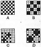
Sail canvas is, naturally, of a strong build, and is quite different from the canvas cloth used for embroidery purposes, often called “art canvas.” The latter is similar in structure to cheese cloths and strainers, the chief difference being that the yarns for art canvas are, in general, of a superior nature. All kinds of vegetable fibres are used in their production, chief among which are cotton, flax and jute. The yarns are almost invariably two or more ply, an arrangement which tends to obtain a uniform thickness—a very desirable element in these open-built fabrics. The plain weave A in the figure is extensively used for these fabrics, but in many cases special weaves are used which leave the open spaces well defined. Thus weave B is often employed, while the “imitation gauze” weaves, C and D, are also largely utilized in the production of these embroidery cloths. Weave B is known as the hopsack, and probably owes its name to being originally used for the making of bags for hops. The cloth for this purpose is now called “hop pocketing,” and is of a structure between bagging and tarpaulin. Another class of canvas, single warp termed “artists’ canvas,” is used, as its name implies, for paintings in oils. It is also much lighter than sail canvas, but must, of necessity, be made of level yarns. The best qualities are made of cream or bleached flax line, although it is not unusual to find an admixture of tow, and even of cotton in the commoner kinds. When the cloth comes from the loom, it undergoes a special treatment to prepare the surface for the paint.
CANVASS (an older spelling of “canvas”), to sift by shaking in a sheet of canvas, hence to discuss thoroughly; as a political term it means to examine carefully the chances of the votes in a prospective election, and to solicit the support of the electors.
CANYNGES, Canynge, WILLIAM (c. 1399-1474), English merchant, was born at Bristol in 1399 or 1400, a member of a wealthy family of merchants and cloth-manufacturers in that city. He entered, and in due course greatly extended, the family business, becoming one of the richest Englishmen of his day. Canynges was five times mayor of, and twice member of parliament for, Bristol. He owned a fleet of ten ships, the largest hitherto known in England, and employed, it is said, 800 seamen. By special license from the king of Denmark he enjoyed for some time a monopoly of the fish trade between Iceland, Finland and England, and he also competed successfully with the Flemish merchants in the Baltic, obtaining a large share of their business. In 1456 he entertained Margaret of Anjou at Bristol, and in 1461 Edward IV. Canynges undertook at his own expense the great work of rebuilding the famous Bristol church of St Mary, Redcliffe, and for a long time had a hundred workmen in his regular service for this purpose. In 1467 he himself took holy orders, and in 1469 was made dean of Westbury. He died in 1474. The statesman George Canning and the first viscount Stratford de Redcliffe were descendants of his family.
See Pryce, Memorials of the Canynges Family and their Times (Bristol, 1854).
CANYON (Anglicized form of Span. cañon, a tube, pipe or cannon; the Spanish form being also frequently written), a type of valley with huge precipitous sides, such as the Grand Canyons of the Colorado and the Yellowstone livers, and the gorge of the Niagara river below the falls, due to rapid stream erosion in a “young” land. A river saws its channel vertically downwards, and a swift stream erodes chiefly at the bottom. In rainy regions the valleys thus formed are widened out by slope-wash and the resultant valley-slopes are gentle, but in arid regions there is very little side-extension of the valleys and the river cuts its way downwards, leaving almost vertical cliffs above the stream. If the stream be swift as in the western plateau of North America, the cutting action will be rapid. The ideal conditions for developing a canyon are: great altitude and slope causing swift streams, arid conditions with absence of side-wash, and hard rock horizontally bedded which will hold the walls up.
CANZONE, a form of verse which has reached us from Italian literature, where from the earliest times it has been assiduously cultivated. The word is derived from the Provençal cansò, a song, but it was in Italian first that the form became a literary one, and was dedicated to the highest uses of poetry. The canzone-strophe consists of two parts, the opening one being distinguished by Dante as the fronte, the closing one as the sirma. These parts are connected by rhyme, it being usual to make the rhyme of the last line of the fronte identical with that of the first line of the sirma. In other respects the canzone has great liberty, as regards number and length of lines, arrangement of rhymes and conduct of structure. An examination of the best Italian models, however, shows that the tendency of the canzone-strophe is to possess 9, 10, 11, 13, 14 or 16 verses, and that of these the strophe of 14 verses is so far the most frequent that it may almost be taken as the type. In this form it resembles an irregular sonnet. The Vita Nuova contains many examples of the canzone, and these are accompanied by so many explanations of their form as to lead us to believe that the canzone was originally invented or adopted by Dante. The following is the proemio or fronte of one of the most celebrated canzoni in the Vita Nuova (which may be studied in English in Dante Gabriel Rossetti’s translation):—
“Donna pietosa e di novella etate, Adorna assai di gentilezza umane, Era là ov’ io chiamava spesso Morte. Veggendo gli occhi miei pien di pietate, Ed ascoltando le parole vane, Si mosse con paura a pianger forte; Ed altro donne, che si furo accorte Di me per quella che meco piangia, Fecer lei partir via Ed apprissârsi per farmi sentire. Quel dicea: ‘Non dormire’; E qual dicea: ‘Perchè sì te sconforte?’ Allor lasciai la nuova fantasia, Chiamando il nome della donna mia.”
The Canzoniere of Petrarch is of great authority as to the form of this species of verse. In England the canzone was introduced at the end of the sixteenth century by William Drummond of Hawthornden, who has left some very beautiful examples. In German poetry it was cultivated by A.W. von Schlegel and other poets of the Romantic period. It is doubtful, however, whether it is in agreement with the genius of any language but Italian, and whether the genuine “Canzone toscana” is a form which can be reproduced elsewhere than in Italy.
(E. G.)
CAPE BRETON, the north-east portion of Nova Scotia, Canada, separated from the mainland by a narrow strait, known as the Gut of Canceau or Canso. Its extreme length from north to south is about 110 m., greatest breadth about 87 m., and area 3120 sq. m. It juts out so far into the Atlantic that it has been called “the long wharf of Canada,” the distance to the west coast of Ireland being less by a thousand miles than from New York. A headland on the east coast is also known as Cape Breton, and is said by some to be the first land made by Cabot on his voyage in 1497-1498. The large, irregularly-shaped, salt-water lakes of Bras d’Or communicate with the sea by two channels on the north-east; a short ship canal connects them with St Peter’s bay on the south, thus dividing the island into two parts. Except on the north-west, the coast-line is very irregular, and indented with numerous bays, several of which form excellent harbours. The most important are Aspy, St Ann’s, Sydney, Mira, Louisburg, Gabarus, St Peter’s and Mabou; of these, Sydney Harbour, on which are situated the towns of Sydney and North Sydney, is one of the finest in North America. There are numerous rivers, chiefly rapid hill streams not navigable for any distance; the largest are the Denys, the Margaree, the Baddeck and the Mira. Lake Ainslie in the west is the most extensive of several fresh-water lakes. The surface of the island is broken in several places by ranges of hills of moderate elevation, well wooded, and containing numerous picturesque glens and gorges; the northern promontory consists of a plateau, rising at Cape North to a height of 1800 ft. This northern projection is formed of Laurentian gneiss, the only instance in Nova Scotia of this formation, and is fringed by a narrow border of carboniferous rocks. South of this extends a Cambrian belt, a continuation of the same formation on the Atlantic coast of Nova Scotia. On various portions of the west coast, and on the south side of the island at Seacoal Bay and Little River (Richmond county), valuable seams of coal are worked. Still more important is the Sydney coal-field, which occupies the east coast from Mira Bay to St Ann’s. The outcrop is plainly visible at various points along the coast, and coal has been mined in the neighbourhood from a very early period. Since 1893 the operations have been greatly extended, and over 3,000,000 tons a year are now shipped, chiefly to Montreal and Boston. The coal is bituminous, of good quality and easily worked, most of the seams dipping at a low angle. Several have been mined for some distance beneath the ocean. Slate, marble, gypsum and limestone are quarried, the latter, which is found in unlimited quantities, being of great value as a flux in the blast-furnaces of Sydney. Copper and iron are also found, though not in large quantities.
Its lumber, agricultural products and fisheries are also important. Nearly covered with forest at the time of its discovery, it still exports pine, oak, beech, maple and ash. Oats, wheat, turnips and potatoes are cultivated, chiefly for home consumption; horses, cattle and sheep are reared in considerable numbers; butter and cheese are exported. The Bras d’Or lakes and the neighbouring seas supply an abundance of cod, mackerel, herring and whitefish, and the fisheries employ over 7000 men. Salmon are caught in several of the rivers, and trout in almost every stream, so that it is visited by large numbers of tourists and sportsmen from the other provinces and from the United States. The Intercolonial railway has been extended to Sydney, and crosses the Gut of Canso on a powerful ferry. From the same strait a railway runs up the west coast, and several shorter lines are controlled by the mining companies. Of these the most important is that connecting Sydney and Louisburg. Numerous steamers, with Sydney as their headquarters, ply upon the Bras d’Or lakes. The inhabitants are mainly of Highland Scottish descent, and Gaelic is largely spoken in the country districts. On the south and west coasts are found a number of descendants of the original French settlers and of the Acadian exiles (see Nova Scotia), and in the mining towns numbers of Irish are employed. Several hundred Mic Mac Indians, for the most part of mixed blood, are principally employed in making baskets, fish-barrels and butter-firkins. Nearly the whole population is divided between the Roman and Presbyterian creeds, and the utmost cordiality marks the relations between the two faiths. The population is steadily increasing, having risen from 27,580 in 1851 to over 100,000 in 1906.
There is some evidence in favour of early Norse and Icelandic voyages to Cape Breton, but they left no trace. It was probably visited by the Cabots in 1497-1498, and its name may either have been bestowed in remembrance of Cap Breton near Bayonne, by the Basque sailors who early frequented the coast, or may commemorate the hardy mariners of Brittany and Normandy.
In 1629 James Stewart, fourth Lord Ochiltree, settled a small colony at Baleine, on the east side of the island; but he was soon after taken prisoner with all his party by Captain Daniell of the French Company, who caused a fort to be erected at Great Cibou (now St Ann’s Harbour). By the peace of St Germain in 1632, Cape Breton was formally assigned to France; and in 1654 it formed part of the territory granted by patent to Nicholas Denys, Sieur de Fronsac, who made several small settlements on the island, which, however, had only a very temporary success. When by the treaty of Utrecht (1713) the French were deprived of Nova Scotia and Newfoundland, they were still left in possession of Cape Breton, and their right to erect fortifications for its defence was formally acknowledged. They accordingly transferred the inhabitants of Plaisance in Newfoundland to the settlement of Havre à l’Anglois, which soon after, under the name of Louisburg, became the capital of Cape Breton (or Ile Royale, as it was then called), and an important military post.
Cod-fishing formed the staple industry, and a large contraband trade in French wines, brandy and sugar, was carried on with the English colonies to the south. In 1745 it was captured by a force of volunteers from New England, under Sir William Pepperell (1696-1759) aided by a British fleet under Commodore Warren (1703-1752). By the treaty of Aix-la-Chapelle, the town was restored to France; but in 1758 was again captured by a British force under General Sir Jeffrey Amherst and Admiral Boscawen. On the conclusion of hostilities the island was ceded to England by the treaty of Paris; and on the 7th of October 1763 it was united by royal proclamation to the government of Nova Scotia. In 1784 it was separated from Nova Scotia, and a new capital founded at the mouth of the Spanish river by Governor Desbarres, which received the name of Sydney in honour of Lord Sydney (Sir Thomas Townshend), then secretary of state for the colonies. There was immediately a considerable influx of settlers to the island, which received another important accession by the immigration of Scottish Highlanders from 1800 to 1828. In 1820, in spite of strong opposition, it was again annexed to Nova Scotia. Since then, its history has been uneventful, chiefly centring in the development of the mining industry.
Bibliography.—Historical: Richard Brown, A History of the Island of Cape Breton (1869), and Sir John Bourinot, Historical and Descriptive Account of Cape Breton (1892), are both excellent. See also Denys, Description géogr. et hist, des côtes de l’Amérique septentrionale (1672); Pichon, Lettres et mémoires du Cap Bréton(1760). General: Reports of Geological Survey, 1872 to 1882-1886, and 1895 to 1899 (by Robb, H. Fletcher and Faribault); H. Fletcher, The Sydney Coal Fields, Cape Breton, N.S. (1900); Richard Brown, The Coal Fields of Cape Breton (1871; reprinted, 1899).
CAPE COAST, a port on the Gold Coast, British West Africa, in 5° 5′ N., 1° 13′ W., about 80 m. W. of Accra. Pop. (1901) 28,948, mostly Fantis. There are about 100 Europeans and a colony of Krumen. The town is built on a low bank of gneiss and micaceous slate which runs out into the sea and affords some protection at the landing-place against the violence of the surf. (This bank was the Cabo Corso of the Portuguese, whence the English corruption of Cape Coast.) The castle faces the sea and is of considerable size and has a somewhat imposing appearance. Next to the castle, used as quarters for military officers and as a prison, the principal buildings are the residence of the district commissioner, the churches and schools of various denominations, the government schools and the colonial hospital. Many of the wealthy natives live in brick-built residences. The streets are hilly, and the town is surrounded on the east and north by high ground, whilst on the west is a lagoon. Fort Victoria lies west of the town, and Fort William (used as a lighthouse) on the east.
The first European settlement on the spot was that of the Portuguese in 1610. In 1652 the Swedes established themselves here and built the castle, which they named Carolusburg. In 1659 the Dutch obtained possession, but the castle was seized in 1664 by the English under Captain (afterwards Admiral Sir) Robert Holmes, and it has not since been captured in spite of an attack by De Ruyter in 1665, a French attack in 1757, and various assaults by the native tribes. Next to Elmina it was considered the strongest fort on the Guinea Coast. Up to 1876 the town was the capital of the British settlements on the coast, the administration being then removed to Accra. It is still one of the chief ports of the Gold Coast Colony, and from it starts the direct road to Kumasi. In 1905 it was granted municipal government. In the courtyard of the castle are buried George Maclean (governor of the colony 1830-1843) and his wife (Laetitia Elizabeth Landon). The graves are marked by two stones bearing respectively the initials “L.E.L.” and “G.M.” The land on the east side of the town is studded with disused gold-diggers’ pits. The natives are divided into seven clans called companies, each under the rule of recognized captains and possessing distinct customs and fetish.
See A. Ffoulkes, “The Company System in Cape Coast Castle,” in Jnl. African Soc. vol. vii., 1908; and Gold Coast.
CAPE COLONY (officially, “Province of the Cape of Good Hope”), the most southern part of Africa, a British possession since 1806. It was named from the promontory on its south-west coast discovered in 1488 by the Portuguese navigator Diaz, and near which the first settlement of Europeans (Dutch) was made in 1652. From 1872 to 1910 a self-governing colony, in the last-named year it entered the Union of South Africa as an original province. Cape Colony as such then ceased to exist. In the present article, however, the word “colony” is retained. The “provinces” referred to are the colonial divisions existing before the passing of the South Africa Act 1909, except in the sections Constitution and Government and Law and Justice, where the changes made by the establishment of the Union are set forth. (See also South Africa.)
Boundaries and Area.—The coast-line extends from the mouth of the Orange (28° 38′ S. 16° 27′ E.) on the W. to the mouth of the Umtamvuna river (31° 4′ S. 30° 12′ E.) on the E., a distance of over 1300 m. Inland the Cape is bounded E. and N.E. by Natal, Basutoland, Orange Free State and the Transvaal; N. by the Bechuanaland Protectorate and N.W. by Great Namaqualand (German S.W. Africa). From N.W. to S.E. the colony has a breadth of 800 m., from S.W. to N.E. 750 m. Its area is 276,995 sq. m.—more than five times the size of England. Walfish Bay (q.v.) on the west coast north of the Orange river is a detached part of Cape Colony.
Physical Features.—The outstanding orographic feature of the country is the terrace-formation of the land, which rises from sea-level by well-marked steps to the immense plateau which forms seven-eighths of South Africa. The coast region varies in width from a few miles to as many as fifty, being narrowest on the south-east side. The western coast line, from the mouth of the Orange to the Cape peninsula, runs in a general south-east direction with no deep indentations save just south of 33° S. where, in Saldanha Bay, is spacious and sheltered anchorage. The shore is barren, consisting largely of stretches of white sand or thin soil sparsely covered with scrub. The Cape peninsula, which forms Table Bay on the north and False Bay on the south, juts pendant beyond the normal coast line and consists of an isolated range of hills. The scenery here becomes bold and picturesque. Dominating Table Bay is the well-known Table Mountain (3549 ft.), flat-topped and often covered with a “tablecloth” of cloud. On its lower slopes and around Table Bay is built Cape Town, capital of the colony. Rounding the storm-vexed Cape of Good Hope the shore trends south-east in a series of curves, forming shallow bays, until at the saw-edged reefs of Cape Agulhas (Portuguese, Needles) in 34° 51′ 15″ S. 20° E. the southernmost point of the African continent is reached. Hence the coast, now very slightly indented, runs north by east until at Algoa Bay (25° 45′ E.) it takes a distinct north-east bend, and so continues beyond the confines of the colony. Along the southern and eastern shore the country is better watered, more fertile and more picturesque than along the western seaboard. Cape Point (Cape of Good Hope) stands 840 ft. above the sea; Cape Agulhas 455 ft. Farther on the green-clad sides of the Uiteniquas Mountains are plainly visible from the sea, and as the traveller by boat proceeds eastward, stretches of forest are seen and numbers of mountain streams carrying their waters to the ocean. In this part of the coast the only good natural harbour is the spacious estuary of the Knysna river in 23° 5′ E. The entrance, which is over a bar with 14 ft. minimum depth of water, is between two bold sandstone cliffs, called the Heads.
Off the coast are a few small islands, mainly mere rocks within the bay. None is far from the mainland. The largest are Dassen Island, 20 m. S. of Saldanha Bay, and Robben Island, at the entrance to Table Bay. St Croix is a rock in Algoa Bay, upon which Diaz is stated to have erected a cross. A number of small islands off the coast of German South-West Africa, chiefly valuable for their guano deposits, also belong to Cape Colony (see Angra Pequena).
Ocean Currents.—Off the east and south shores of the colony the Mozambique or Agulhas current sweeps south-westward with force sufficient to set up a back drift. This back drift or counter current flowing north-east is close in shore and is taken advantage of by vessels going from Cape Town to Natal. On the west coast the current runs northwards. It is a deflected stream from the west drift of the “roaring forties” and coming from Antarctic regions is much colder than the Agulhas current. Off the southern point of the continent the Agulhas current meets the west drift, giving rise to alternate streams of warm and cold water. This part of the coast, subject alike to strong westerly and southeasterly winds, is often tempestuous, as is witnessed by the name, Cabo Tormentoso, given to the Cape of Good Hope, and to the many wrecks off the coast. The most famous was that of the British troopship “Birkenhead,” on the 26th of February 1852, off Danger Point, midway between Cape of Good Hope and Cape Agulhas.
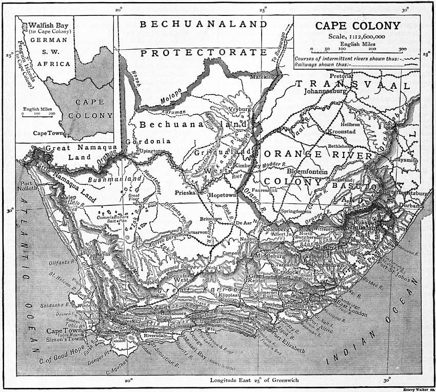
(Click to enlarge.)
Mountains and Tablelands.—It has been stated that the land rises by well-marked steps to a vast central plateau. Beyond the coast plain, which here and there attains a height of 600 ft., are mountain ranges running parallel to the shore. These mountains are the supporting walls of successive terraces. When the steep southern sides of the ranges nearest the sea are ascended the hills are often found to be flat-topped with a gentle slope northward giving on to a plateau rarely more than 40 m. wide. This plateau is called the Southern or Little Karroo, Karroo being a corruption of a Hottentot word meaning dry, arid. Having crossed the Little Karroo, from which rise minor mountain chains, a second high range has to be climbed. This done the traveller finds himself on another tableland—the Great Karroo. It has an average width of 80 m. and is about 350 m. long. Northwards the Karroo (q.v.) is bounded by the ramparts of the great inner tableland, of which only a comparatively small portion is in Cape Colony. This sequence of hill and plain—namely (1) the coast plain, (2) first range of hills, (3) first plateau (Little Karroo), (4) second range of hills, (5) second plateau (the Great Karroo), (6) main chain of mountains guarding, (7) the vast interior tableland—is characteristic of the greater part of the colony but is not clearly marked in the south-east and north-west borders. The innermost, and most lofty, chain of mountains follows a curve almost identical with that of the coast at a general distance of 120 m. from the ocean. It is known in different places under different names, and the same name being also often given to one or more of the coast ranges the nomenclature of the mountains is confusing (see the map). The most elevated portion of the innermost range, the Drakensberg (q.v.) follows the curve of the coast from south to north-east. Only the southern slopes of the range are in Cape Colony, the highest peaks—over 10,000 ft.—being in Basutoland and Natal. Going westward from the Drakensberg the rampart is known successively as the Stormberg, Zuurberg, Sneeuwberg and Nieuwveld mountains. These four ranges face directly south. In the Sneeuwberg range is Compass Berg, 8500 ft. above the sea, the highest point in the colony. In the Nieuwveld are heights of over 6000 ft. The Komsberg range, which joins the Nieuwveld on the east, sweeps from the south to the north-west and is followed by the Roggeveld mountains, which face the western seaboard. North of the Roggeveld the interior plateau approaches closer to the sea than in southern Cape Colony. The slope of the plateau being also westward, the mountain rampart is less elevated, and north of 32° S. few points attain 5000 ft. The coast ranges are here, in Namaqualand and the district of Van Rhyns Dorp, but the outer edges of the inner range. They attain their highest point in the Kamies Berg, 5511 ft. above the sea. Northward the Orange river, marking the frontier of the colony, cuts its way through the hills to the Atlantic.
From the Olifants river on the west to the Kei river on the east the series of parallel ranges, which are the walls of the terraces between the inner tableland and the sea, are clearly traceable. Their general direction is always that of the coast, and they are cut across by rugged gorges or kloofs, through which the mountain streams make their way towards the sea. The two chief chains, to distinguish them from the inner chain already described, may be called the coast and central chains. Each has many local names. West to east the central chain is known as the Cedarberg, Groote Zwarteberg (highest point 6988 ft.), Groote river, Winterhoek (with Cockscomb mountain 5773 ft. high) and Zuurberg ranges. The Zuurberg, owing to the north-east trend of the shore, becomes, east of Port Elizabeth, a coast range, and the central chain is represented by a more northerly line of hills, with a dozen different names, which are a south-easterly spur of the Sneeuwberg. In this range the Great Winter Berg attains a height of 7800 ft.
The coast chain is represented west to east by the Olifants mountains (with Great Winterhoek, 6618 ft. high), Drakenstein, Zonder Einde, Langeberg (highest point 5614 ft.), Attaquas, Uiteniquas and various other ranges. In consequence of the north-east trend of the coast, already noted, several of these ranges end in the sea in bold bluffs. From the coast plain rise many short ranges of considerable elevation, and on the east side of False Bay parallel to Table Bay range is a mountain chain with heights of 4000 and 5000 ft. East of the Kei river the whole of the country within Cape Colony, save the narrow seaboard, is mountainous. The southern part is largely occupied with spurs of the Stormberg; the northern portion, Griqualand East and Pondoland, with the flanks of the Drakensberg. Several peaks exceed 7000 ft. in height. Zwart Berg, near the Basuto-Natal frontier, rises 7615 ft. above the sea. Mount Currie, farther south, is 7296 ft. high. The Witte Bergen (over 5000 ft. high) are an inner spur of the Drakensberg running through the Herschel district.
That part of the inner tableland of South Africa which is in the colony has an average elevation of 3000 ft., being higher in the eastern than in the western districts. It consists of wide rolling treeless plains scarred by the beds of many rivers, often dry for a great part of the year. The tableland is broken by the Orange river, which traverses its whole length. North of the river the plateau slopes northward to a level sometimes as low as 2000 ft. The country is of an even more desolate character than south of the Orange (see Bechuanaland). Rising from the plains are chains of isolated flat-topped hills such as the Karree Bergen, the Asbestos mountains and Kuruman hills, comparatively unimportant ranges.
Although the mountains present bold and picturesque outlines on their outward faces, the general aspect of the country north of the coast-lands, except in its south-eastern corner, is bare and monotonous. The flat and round-topped hills (kopjes), which are very numerous on the various plateaus, scarcely afford relief to the eye, which searches the sun-scorched landscape, usually in vain, for running water. The absence of water and of large trees is one of the most abiding impressions of the traveller. Yet the vast arid plains are covered with shallow beds of the richest soil, which only require the fertilizing power of water to render them available for pasture or agriculture. After the periodical rains, the Karroo and the great plains of Bushmanland are converted into vast fields of grass and flowering shrubs, but the summer sun reduces them again to a barren and burnt-up aspect. The pastoral lands or velds are distinguished according to the nature of their herbage as “sweet” or “sour.” Shallow sheets of water termed vleis, usually brackish, accumulate after heavy rain at many places in the plateaus; in the dry seasons these spots, where the soil is not excessively saline, are covered with rich grass and afford favourite grazing land for cattle. Only in the southern coast-land of the colony is there a soil and moisture supply suited to forest growth.
Rivers.—The inner chain of mountains forms the watershed of the colony. North of this great rampart the country drains to the Orange (q.v.), which flows from east to west nearly across the continent. For a considerable distance, both in its upper and lower courses, the river forms the northern frontier of Cape Colony. In the middle section, where both banks are in the colony, the Orange receives from the north-east its greatest tributary, the Vaal (q.v.). The Vaal, within the boundaries of the colony, is increased by the Harts river from the north-east and the Riet river from the south-east, whilst just within the colony the Riet is joined by the Modder. All these tributaries of the Orange flow, in their lower courses, through the eastern part of Griqualand West, the only well-watered portion of the colony north of the mountains. From the north, below the Vaal confluence, the Nosob, Molopo and Kuruman, intermittent streams which traverse Bechuanaland, send their occasional surplus waters to the Orange. In general these rivers lose themselves in some vlei in the desert land. The Molopo and Nosob mark the frontier between the Bechuanaland Protectorate and the Cape; the Kuruman lies wholly within the colony. From the south a number of streams, the Brak and Ongers, the Zak and Olifants Vlei (the two last uniting to form the Hartebeest), flow north towards the Orange in its middle course. Dry for a great part of the year, these streams rarely add anything to the volume of the Orange.
South of the inner chain the drainage is direct to the Atlantic or Indian Oceans. Rising at considerable elevations, the coast rivers fall thousands of feet in comparatively short courses, and many are little else than mountain torrents. They make their way down the mountain sides through great gorges, and are noted in the eastern part of the country for their extremely sinuous course. Impetuous and magnificent streams after heavy rain, they become in the summer mere rivulets, or even dry up altogether. In almost every instance the mouths of the rivers are obstructed by sand bars. Thus, as is the case of the Orange river also, they are, with rare exceptions, unnavigable.
Omitting small streams, the coast rivers running to the Atlantic are the Buffalo, Olifants and Berg. It may be pointed out here that the same name is repeatedly applied throughout South Africa to different streams, Buffalo, Olifants (elephants’) and Groote (great) being favourite designations. They all occur more than once in Cape Colony. Of the west coast rivers, the Buffalo, about 125 m. long, the most northern and least important, flows through Little Namaqualand. The Olifants (150 m.), which generally contains a fair depth of water, rises in the Winterhoek mountains and flows north between the Cedarberg and Olifants ranges. The Doorn, a stream with a somewhat parallel but more easterly course, joins the Olifants about 50 m. above its mouth, the Atlantic being reached by a semicircular sweep to the south-west. The Berg river (125 m.) rises in the district of French Hoek and flows through fertile country, in a north-westerly direction, to the sea at St Helena Bay. It is navigable for a few miles from its mouth.
On the south coast the most westerly stream of any size is the Breede (about 165 m. long), so named from its low banks and broad channel. Rising in the Warm Bokkeveld, it pierces the mountains by Mitchell’s Pass, flows by the picturesque towns of Ceres and Worcester, and receives, beyond the last-named place, the waters which descend from the famous Hex River Pass. The Breede thence follows the line of the Langeberg mountains as far as Swellendam, where it turns south, and traversing the coast plain, reaches the sea in St Sebastian Bay. From its mouth the river is navigable by small vessels for from 30 to 40 m. East of the Breede the following rivers, all having their rise on the inner mountain chain, are passed in the order named:—Gouritz (200 m.),1 Gamtoos (290 m.), Sunday (190 m.), Great Salt (230 m.), Kei (150 m.), Bashee (90 m.) and Umzimvuba or St John’s (140 m.).
The Gouritz is formed by the junction of two streams, the Gamka and the Olifants. The Gamka rises in the Nieuwveld not far from Beaufort West, traverses the Great Karroo from north to south, and forces a passage through the Zwarteberg. Crossing the Little Karroo, it is joined from the east by the Olifants (115 m.), a stream which rises in the Great Karroo, being known in its upper course as the Traka, and pierces the Zwarteberg near its eastern end. Thence it flows west across the Little Karroo past Oudtshoorn to its junction with the Gamka. The united stream, which takes the name of Gouritz, flows south, and receives from the west, a few miles above the point where it breaks through the coast range, a tributary (125 m.) bearing the common name Groote, but known in its upper course as the Buffels. Its headwaters are in the Komsberg. The Touws (90 m.), which rises in the Great Karroo not far from the sources of the Hex river, is a tributary of the Groote river. Below the Groote the Gouritz receives no important tributaries and enters the Indian Ocean at a point 20 m. south-west of Mossel Bay.
The Gamtoos is also formed by the junction of two streams, the Kouga, an unimportant river which rises in the coast hills, and the Groote river. This, the Groote river of Cape Colony, has its rise in the Nieuwveld near Nels Poort, being known in its upper course as the Salt river. Flowing south-east, it is joined by the Kariega on the left, and breaking through the escarpment of the Great Karroo, on the lower level changes its name to the Groote, the hills which overhang it to the north-east being known as Groote River Heights. Bending south, the Groote river passes through the coast chain by Cockscomb mountain, and being joined by the Kouga, flows on as the Gamtoos to the sea at St Francis Bay.
Sunday river does not, like so many of the Cape streams, change its name on passing from the Great to the Little Karroo and again on reaching the coast plain. It rises in the Sneeuwberg north-west of Graaff Reinet, flows south-east through one of the most fertile districts of the Great Karroo, which it pierces at the western end of the Zuurberg (of the coast chain), and reaches the ocean in Algoa Bay.
Great Salt river is formed by the junction of the Kat with the Great Fish river, which is the main stream. Several small streams rising in the Zuurberg (of the inner chain) unite to form the Great Fish river which passes through Cradock, and crossing the Karroo, changes its general direction from south to east, and is joined by the Kooner (or Koonap) and Kat, both of which rise in the Winterberg. Thence, as the Great Salt river, it winds south to the sea. Great Fish river is distinguished for the sudden and great rise of its waters after heavy rain and for its exceedingly sinuous course. Thus near Cookhouse railway station it makes an almost circular bend of 20 m., the ends being scarcely 2 m. apart, in which distance it falls 200 ft. Although, like the other streams which cross the Karroo, the river is sometimes dry in its upper course, it has an estimated annual discharge of 51,724,000,000 cubic ft.
The head-streams of the Kei, often called the Great Kei, rise in the Stormberg, and the river, which resembles the Great Fish in its many twists, flows in a general south-east direction through mountainous country until it reaches the coast plain. Its mouth is 40 m. in a direct line north-east of East London. In the history of the Cape the Kei plays an important part as long marking the boundary between the colony and the independent Kaffir tribes. (For the Umzimvuba and other Transkei rivers see Kaffraria.)
Of the rivers rising in the coast chain the Knysna (30 m.), Kowie (40 m.), Keiskama (75 m.) and Buffalo (45 m.) may be mentioned. The Knysna rises in the Uiteniquas hills and is of importance as a feeder of the lagoon or estuary of the same name, one of the few good harbours on the coast. The banks of the Knysna are very picturesque. Kowie river, which rises in the Zuurberg mountains near Graham’s Town, is also noted for the beauty of its banks. At its mouth is Port Alfred. The water over the bar permits the entrance of vessels of 10 to 12 ft. draught. The Buffalo river rises in the hilly country north of King William’s Town, past which it flows. At the mouth of the river, where the scenery is very fine, is East London, third in importance of the ports of Cape Colony.
The frequency of “fontein” among the place names of the colony bears evidence of the number of springs in the country. They are often found on the flat-topped hills which dot the Karroo. Besides the ordinary springs, mineral and thermal springs are found in several places.
Lakes and Caves.—Cape Colony does not possess any lakes properly so called. There are, however, numerous natural basins which, filled after heavy rain, rapidly dry up, leaving an incrustation of salt on the ground, whence their name of salt pans. The largest, Commissioner’s Salt Pan, in the arid north-west district, is 18 to 20 m. in circumference. Besides these pans there are in the interior plateaus many shallow pools or vleis whose extent varies according to the dryness or moisture of the climate. West of Knysna, and separated from the seashore by a sandbank only, are a series of five vleis, turned in flood times into one sheet of water and sending occasional spills to the ocean. These vleis are known collectively as “the lakes.” In the Zwarteberg of the central chain are the Cango Caves, a remarkable series of caverns containing many thousand of stalactites and stalagmites. These caves, distant 20 m. from Oudtshoorn, have been formed in a dolomite limestone bed about 800 ft. thick. There are over 120 separate chambers, the caverns extending nearly a mile in a straight line.
Climate.—The climate of Cape Colony is noted for its healthiness. Its chief characteristics are the dryness and clearness of the atmosphere and the considerable daily range in temperature; whilst nevertheless the extremes of heat and cold are rarely encountered. The mean annual temperature over the greater part of the country is under 65° F. The chief agents in determining the climate are the vast masses of water in the southern hemisphere and the elevation of the land. The large extent of ocean is primarily responsible for the lower temperature of the air in places south of the tropics compared with that experienced in countries in the same latitude north of the equator. Thus Cape Town, about 34° S., has a mean temperature, 63° F., which corresponds with that of the French and Italian Riviera, in 41° to 43° N. For the dryness of the atmosphere the elevation of the country is responsible. The east and south-east winds, which contain most moisture, dissipate their strength against the Drakensberg and other mountain ranges which guard the interior. Thus while the coast-lands, especially in the south-east, enjoy an ample rainfall, the winds as they advance west and north contain less and less moisture, so that over the larger part of the country drought is common and severe. Along the valley of the lower Orange rain does not fall for years together. The drought is increased in intensity by the occasional hot dry wind from the desert region in the north, though this wind is usually followed by violent thunderstorms.
Whilst the general characteristics of the climate are as here outlined, in a country of so large an area as Cape Colony there are many variations in different districts. In the coast-lands the daily range of the thermometer is less marked than in the interior and the humidity of the atmosphere is much greater. Nevertheless, the west coast north of the Olifants river is practically rainless and there is great difference between day and night temperatures, this part of the coast sharing the characteristics of the interior plateau. The division of the year into four seasons is not clearly marked save in the Cape peninsula, where exceptional conditions prevail. In general the seasons are but two—summer and winter, summer lasting from September to April and winter filling up the rest of the year. The greatest heat is experienced in December, January and February, whilst June and July are the coldest months. In the western part of the colony the winter is the rainy season, in the eastern part the chief rains come in summer. A line drawn from Port Elizabeth north-west across the Karroo in the direction of Walfish Bay roughly divides the regions of the winter and summer rains. All the country north of the central mountain chain and west of 23° E., including the western part of the Great Karroo, has a mean annual rainfall of under 12 in. East of the 23° E. the plateaus have a mean annual rainfall ranging from 12 to 25 in. The western coast-lands and the Little Karroo have a rainfall of from 10 to 20 in.; the Cape peninsula by exception having an average yearly rainfall of 40 in. (see Cape Town). Along the south coast and in the south-east the mean annual rainfall exceeds 25 in., and is over 50 in. at some stations. The rain falls, generally, in heavy and sudden storms, and frequently washes away the surface soil. The mean annual temperature of the coast region, which, as stated, is 63° F. at Cape Town, increases to the east, the coast not only trending north towards the equator but feeling the effect of the warm Mozambique or Agulhas current.
On the Karroo the mean maximum temperature is 77° F., the mean minimum 49°, the mean daily range about 27°. In summer the drought is severe, the heat during the day great, the nights cool and clear. In winter frost at night is not uncommon. The climate of the northern plains is similar to that of the Karroo, but the extremes of cold and heat are greater. In the summer the shade temperature reaches 110° F., whilst in winter nights 12° of frost have been registered. The hot westerly winds of summer make the air oppressive, though violent thunderstorms, in which form the northern districts receive most of their scanty rainfall, occasionally clear the atmosphere. Mirages are occasionally seen. The keen air, accompanied by the brilliant sunshine, renders the winter climate very enjoyable. Snow seldom falls in the coast region, but it lies on the higher mountains for three or four months in the year, and for as many days on the Karroo. Violent hailstorms, which do great damage, sometimes follow periods of drought. The most disagreeable feature of the climate of the colony is the abundance of dust, which seems to be blown by every wind, and is especially prevalent in the rainy season.
That white men can thrive and work in Cape Colony the history of South Africa amply demonstrates. Ten generations of settlers, from northern Europe have been born, lived and died there, and the race is as strong and vigorous as that from which it sprang. Malarial fever is practically non-existent in Cape Colony, and diseases of the chest are rare.
(F. R. C.)
Geology.—The colony affords the typical development of the geological succession south of the Zambezi. The following general arrangement has been determined:—
Table Of Formations. Post-Cretaceous and Recent.
Cretaceous System Pondoland Cretaceous Series Uitenhage Series Cretaceous
Karroo System Stormberg Series Beaufort Series Ecca Series Dwyka Series Carboniferous
Cape System Witteberg Series Bokkeveld Series Table Mountain Sandstone Series Devonian
Pre-Cape Rocks Includes several independent unfossiliferous formations of pre-Devonian age Archaean to Silurian(?)
The general structure of the colony is simple. It may be regarded as a shallow basin occupied by the almost horizontal rocks of the Karroo. These form the plains and plateaus of the interior. Rocks of pre-Cape age rise from beneath them on the north and west; on the south and east the Lower Karroo and Cape systems are bent up into sharp folds, beneath which, but in quite limited areas, the pre-Cape rocks emerge. In the folded regions the strike conforms to the coastal outline on the south and east.
Pre-Cape rocks occur in three regions, presenting a different development in each:—
North. West. South.
Matsap Series Nieuwerust Beds Cango Beds
Ongeluk Volcanic Series
Griquatown Series Ibiquas Beds
Campbell Rand Series
Black Reef Series
Pniel Volcanic Series
Keis Series
Namaqualand Schists Namaqualand Schists and Malmesbury Beds Malmesbury Beds
The pre-Cape rocks are but little understood. They no doubt represent formations of widely different ages, but all that can be said is that they are greatly older than the Cape System. The hope that they will yield fossils has been held out but not yet fulfilled. Their total thickness amounts to several thousand feet. The rocks have been greatly changed by pressure in most cases and by the intrusion of great masses of igneous material, the Namaqualand schists and Malmesbury beds being most altered.
The most prominent member of the Cango series is a coarse conglomerate; the other rocks include slates, limestone and porphyroids. The Ibiquas beds consist of conglomerates and grits. Both the Cango and Ibiquas series have been invaded by granite of older date than the Table Mountain series. The Nieuwerust beds contain quartzite, arkose and shales. They rest indifferently on the Ibiquas series or Malmesbury beds.
The pre-Cape rocks of the northern region occur in the Campbell Rand, Asbestos mountains, Matsap and Langebergen, and in the Schuftebergen. They contain a great variety of sediments and igneous rocks. The oldest, or Keis, series consists of quartzites, quartz-schists, phyllites and conglomerates. These are overlain, perhaps unconformably, by a great thickness of lavas and volcanic breccias (Pniel volcanic series, Beer Vley and Zeekoe Baard amygdaloids), and these in turn by the quartzites, grits and shales of the Black Reef series. The chief rocks of the Campbell Rand series are limestones and dolomites, with some interbedded quartzites. Among the Griquatown series of quartzites, limestones and shales are numerous bands of jasper and large quantities of crocidolite (a fibrous amphibole); while at Blink Klip a curious breccia, over 200 ft. thick, is locally developed. Evidences of one of the oldest known glaciations have been found near the summit in the district of Hay. The Ongeluk volcanic series, consisting of lavas and breccias, conformably overlies the Griquatown series; while the grits, quartzites and conglomerates of the Matsap series rest on them with a great discordance.
Rocks of the Cape System have only been met with in the southern and eastern parts of South Africa. The lowest member (Table Mountain Sandstone) consists of sandstones with subordinate bands of shale. It forms the upper part of Table Mountain and enters largely into the formation of the southern mountainous folded belt. It is unfossiliferous except for a few obscure sheils obtained near the base. A bed of conglomerate is regarded as of glacial origin.
The Table Mountain Sandstone passes up conformably into a sequence of sandstones and shales (Bokkeveld Beds), well exposed in the Cold and Warm Bokkevelds. The lowest beds contain many fossils, including Phacops, Homalonotus, Leptocoelia, Spirifer, Chonetes, Orthothetes, Orthoceras, Bellerophon. Many of the species are common to the Devonian rocks of the Falkland Islands, North and South America and Europe, with perhaps a closer resemblance to the Devonian fauna of South America than to that of any other country.
The Bokkeveld beds are conformably succeeded by the sandstones, quartzites and shales of the Witteberg series. So far imperfect remains of plants (Spirophyton) are the only fossils, and these are not sufficient to determine if the beds belong to the Devonian or Carboniferous System.
The thickness of the rocks of the Cape System exceeds 5000 ft.
The Karroo System is par excellence the geological formation of South Africa. The greater part of the colony belongs to it, as do large tracts in the Orange Free State and Transvaal. It includes the following well-defined subdivisions:—
Feet.
Stormberg Serie Volcanic Beds 4000 Jurassic
Cave Sandstone 800
Red Beds 1400
Molteno Beds 2000 Trias
Beaufort Series Burghersdorp Beds 5000
Dicynodon Beds
Pareiasaurus Beds Permian
Ecca Series Shales and Sandstones 2600
Laingsburg Beds Carboniferus
Shales
Dwyka Series Upper Shales 600
Conglomerates 1000
Lower Shales 700
In the southern areas the Karroo formation follows the Cape System conformably; in the north it rests unconformably on very much older rocks. The most remarkable deposits are the conglomerates of the Dwyka series. These afford the clearest evidences of glaciation on a great scale in early Carboniferous times. The deposit strictly resembles a consolidated modern boulder clay. It is full of huge glaciated blocks, and in different regions (Prieska chiefly) the underlying pavement is remarkably striated and shows that the ice was moving southward. The upper shales contain the small reptile Mesosaurus tenuidens.
Plants constitute the chief fossils of the Ecca series; among others they include Glossopteris, Gangamopteris, Phyllotheca. The Beaufort series is noted for the numerous remains of remarkable and often gigantic reptiles it contains. The genera and species are numerous, Dicynodon, Oudenodon, Pareiasaurus being the best known. Among plants Glossopteris occurs for the last time. The Stormberg series occurs in the mountainous regions of the Stormberg and Drakensberg. The Molteno beds contain several workable seams of coal. The most remarkable feature of the series is the evidence of volcanic activity on an extensive scale. The greater part of the volcanic series is formed by lava streams of great thickness. Dykes and intrusive sheets, most of which end at the folded belt, are also numerous. The age of the intrusive sheets met with in the Beaufort series is usually attributed to the Stormberg period. They form the kopjes, or characteristic flat-topped hills of the Great Karroo. The Stormberg series contains the remains of numerous reptiles. A true crocodile, Notochampsa, has been discovered in the Red Beds and Cave Sandstone. Among the plants, Thinnfeldia and Taeniopteris are common. Three genera of fossil fishes, Cleithrolepis, Semionotus and Ceratodus, ascend from the Beaufort series into the Cave Sandstone.
Cretaceous rocks occur only near the coast. The plants of the Uitenhage beds bear a close resemblance to those of the Wealden. The marine fauna of Sunday river indicates a Neocomian age. The chief genera are Hamites, Baculites, Crioceras, Olcostephanus and certain Trigoniae.
The superficial post-Cretaceous and Recent deposits are widely spread. High-level gravels occur from 600 to 2000 ft. above the sea. The remains of a gigantic ox, Bubalus Baini, have been obtained from the alluvium near the Modder river. The recent deposits indicate that the land has risen for a long period.
(W. G.*)
Fauna.—The fauna is very varied, but some of the wild animals common in the early days of the colony have been exterminated (e.g. quagga and blaauwbok), and others (e.g. the lion, rhinoceros, giraffe) driven beyond the confines of the Cape. Other game have been so reduced in numbers as to require special protection. This class includes the elephant (now found only in the Knysna and neighbouring forest regions), buffalo and zebra (strictly preserved, and confined to much the same regions as the elephant), eland, oribi, koodoo, haartebeest and other kinds of antelope and gnu. The leopard is not protected, but lingers in the mountainous districts. Cheetahs are also found, including a rare woolly variety peculiar to the Karroo. Both the leopards and cheetahs are commonly spoken of in South Africa as tigers. Other carnivora more or less common to the colony are the spotted hyena, aard-wolf (or Proteles), silver jackal, the Otocyon or Cape wild dog, and various kinds of wild cats. Of ungulata, besides a few hundreds of rare varieties, there are the springbuck, of which great herds still wander on the open veld, the steinbok, a small and beautiful animal which is sometimes coursed like a hare, the klipspringer or “chamois of South Africa,” common in the mountains, the wart-hog and the dassie or rock rabbit. There are two or three varieties of hares, and a species of jerboa and several genera of mongooses. The English rabbit has been introduced into Robben Island, but is excluded from the mainland. The ant-bear, with very long snout, tongue and ears, is found on the Karroo, where it makes inroads on the ant-heaps which dot the plain. There is also a scaly ant-eater and various species of pangolins, of arboreal habit, which live on ants. Baboons are found in the mountains and forests, otters in the rivers. Of reptiles there are the crocodile, confined to the Transkei rivers, several kinds of snakes, including the cobra di capello and puff adder, numerous lizards and various tortoises, including the leopard tortoise, the largest of the continental land forms. Of birds the ostrich may still be found wild in some regions. The great kori bustard is sometimes as much as 5 ft. high. Other game birds include the francolin, quail, guinea-fowl, sand-grouse, snipe, wild duck, wild goose, widgeon, teal, plover and rail. Birds of prey include the bearded vulture, aasvogel and several varieties of eagles, hawks, falcons and owls. Cranes, storks, flamingoes and pelicans are found in large variety.
Parrots are rarely seen. The greater number of birds belong to the order Passeres; starlings, weavers and larks are very common, the Cape canary, long-tailed sugar bird, pipits and wagtails are fairly numerous. The English starling is stated to be the only European bird to have thoroughly established itself in the colony. The Cape sparrow has completely acclimatized itself to town life and prevented the English sparrow obtaining a footing.
Large toads and frogs are common, as are scorpions, tarantula spiders, butterflies, hornets and stinging ants. In some districts the tsetse fly causes great havoc. The most interesting of the endemic insectivora is the Chrysochloris or “golden mole,” so called from the brilliant yellow lustre of its fur. There are not many varieties of freshwater fish, the commonest being the baba or cat-fish and the yellow fish. Both are of large size, the baba weighing as much as 70 ℔. The smallest variety is the culper or burrowing perch. In some of the vleis and streams in which the water is intermittent the fish preserve life by burrowing into the ooze. Trout have been introduced into several rivers and have become acclimatized. Of sea fish there are more than forty edible varieties. The snock, the steenbrass and geelbeck are common in the estuaries and bays. Seals and sharks are also common in the waters of the Cape. Whales visit the coast for the purpose of calving.
Of the domestic animals, sheep, cattle and dogs were possessed by the natives when the country was discovered by Europeans. The various farm animals introduced by the whites have thriven well (see below, Agriculture).
Flora.—The flora is rich and remarkably varied in the coast districts. On the Karroo and the interior plateau there is less variety. In all, some 10,000 different species have been noted in the colony, about 450 genera being peculiar to the Cape. The bush of the coast districts and lower hills consists largely of heaths, of which there are over 400 species. The heaths and the rhenoster or rhinoceros wood, a plant 1 to 2 ft. high resembling heather, form the characteristic features of the flora of the districts indicated. The prevailing bloom is pink coloured. The deciduous plants lose their foliage in the dry season but revive with the winter rains. Notable among the flowers are the arum lily and the iris. The pelargonium group, including many varieties of geranium, is widely represented. In the eastern coast-lands the vegetation becomes distinctly sub-tropical. Of pod-bearing plants there are upwards of eighty genera: Cape “everlasting” flowers (generally species of Helichrysum) are in great numbers. Several species of aloe are indigenous to the Cape. The so-called American aloe has also been naturalized. The castor-oil plant and many other plants of great value in medicine are indigenous in great abundance. Among plants remarkable in their appearance and structure may be noted the cactus-like Euphorbiae or spurge plants, the Stapelia or carrion flower, and the elephant’s foot or Hottentots’ bread, a plant of the same order as the yam. Hooks, thorns and prickles are characteristic of many South African plants.
Forests are confined to the seaward slopes of the coast ranges facing south. They cover between 500 and 600 sq. m. The forests contain a great variety of useful woods, affording excellent timber; among the commonest trees are the yellow wood, which is also one of the largest, belonging to the yew species; black iron wood; heavy, close-grained and durable stinkhout; melkhout, a white wood used for wheel work; nieshout; and the assegai or Cape lancewood. Forest trees rarely exceed 30 ft. in height and scarcely any attain a greater height than 60 ft. A characteristic Cape tree is Leucadendron argenteum or silver tree, so named from the silver-like lustre of stem and leaves. The so-called cedars, whence the Cedarberg got its name, exist no longer. Among trees introduced by the Dutch or British colonists the oak, poplar, various pines, the Australian blue-gum (eucalyptus) and wattle flourish. The silver wattle grows freely in shifting sands and by its means waste lands, e.g. the Cape Flats, have been reclaimed. The oak grows more rapidly and more luxuriantly than in Europe. There are few indigenous fruits; the kei apple is the fruit of a small tree or shrub found in Kaffraria and the eastern districts, where also the wild and Kaffir plums are common; hard pears, gourds, water melons and species of almond, chestnut and lemon are also native. Almost all the fruits of other countries have been introduced and flourish. On the Karroo the bush consists of dwarf mimosas, wax-heaths and other shrubs, which after the spring rains are gorgeous in blossom (see Karroo). The grass of the interior plains is of a coarse character and yellowish colour, very different from the meadow grasses of England. The “Indian” doab grass is also indigenous.
With regard to mountain flora arborescent shrubs do not reach beyond about 4000 ft. Higher up the slopes are covered with small heath, Bruniaceae, Rutaceae, &c. All plants with permanent foliage are thickly covered with hair. Above 6000 ft. over seventy species of plants of Alpine character have been found.
Races and Population.—The first inhabitants of Cape Colony of whom there is any record were Bushmen and Hottentots (q.v.). The last-named were originally called Quaequaes, and received the name Hottentots from the Dutch. They dwelt chiefly in the south-west and north-west parts of the country; elsewhere the inhabitants were of Bantu negroid stock, and to them was applied the name Kaffir. When the Cape was discovered by Europeans, the population, except along the coast, was very scanty and it is so still. The advent of Dutch settlers and a few Huguenot families in the 17th century was followed in the 19th century by that of English and German immigrants. The Bushmen retreated before the white races and now few are to be found in the colony. These live chiefly in the districts bordering the Orange river. The tribal organization of the Hottentots has been broken up, and probably no pure bred representatives of the race survive in the colony.
Half-breeds of mixed Hottentot, Dutch and Kaffir blood now form the bulk of the native population west of the Great Fish river. Of Kaffir tribes the most important living north of the Orange river are the Bechuanas, whilst in the eastern province and Kaffraria live the Fingoes, Tembus and Pondos. The Amaxosa are the principal Kaffir tribe in Cape Colony proper. The Griquas (or Bastaards) are descendants of Dutch-Hottentot half-castes. They give their name to two tracts of country. During the slavery period many thousands of negroes were imported, chiefly from the Guinea coast. The negroes have been largely assimilated by the Kaffir tribes. (For particulars of the native races see their separate articles.) Of the white races in the Colony the French element has been completely absorbed in the Dutch. They and the German settlers are mainly pastoral people. The Dutch, who have retained in a debased form their own language, also engage largely in agriculture and viticulture. Of fine physique and hardy constitution, they are of strongly independent character; patriarchal in their family life; shrewd, slim and courageous; in religion Protestants of a somewhat austere type. Education is somewhat neglected by them, and the percentage of illiteracy among adults is high. They are firm believers in the inferiority of the black races and regard servitude as their natural lot. The British settlers have developed few characteristics differing from the home type. The British element of the community is largely resident in the towns, and is generally engaged in trade or in professional pursuits; but in the eastern provinces the bulk of the farmers are English or German; the German farmers being found in the district between King William’s Town and East London, and on the Cape Peninsula. Numbers of them retain their own language. The term “Africander” is sometimes applied to all white residents in Cape Colony and throughout British South Africa, but is often restricted to the Dutch-speaking colonists. “Boer,” i.e. farmer, as a synonym for “Dutch,” is not in general use in Cape Colony.
Besides the black and white races there is a large colony of Malays in Cape Town and district, originally introduced by the Dutch as slaves. These people are largely leavened with foreign elements and, professing Mahommedanism, religion rather than race is their bond of union. They add greatly by their picturesque dress to the gaiety of the street scenes. They are generally small traders, but many are wealthy. There are also a number of Indians in the colony. English is the language of the towns; elsewhere, except in the eastern provinces, the taal or vernacular Dutch is the tongue of the majority of the whites, as it is of the natives in the western provinces.
The first census was taken in 1865 when the population of the colony, which then had an area of 195,000 sq. m., and did not include the comparatively densely-populated Native Territories, was 566,158. Of these the Europeans numbered 187,400 or about 33% of the whole. Of the coloured races the Hottentots and Bushmen were estimated at 82,000, whilst the Kaffirs formed about 50% of the population. Since 1865 censuses have been taken—in 1875, 1891 and 1904. In 1875 Basutoland formed part of the colony; in 1891 Transkei, Tembuland, Griqualand East, Griqualand West and Walfish Bay had been incorporated, and Basutoland had been disannexed; and in 1904 Pondoland and British Bechuanaland had been added. The following table gives the area and population at each of the three periods.
1875. 1891. 1904.
Area. sq. m. Pop. Area. sq. m. Pop. Area. sq. m. Pop.
201,136 849,160 260,918 1,527,224 276,995 2,409,804
The 1875 census gave the population of the colony proper at 720,984, and that of Basutoland at 128,176. The colony is officially divided into nine provinces, but is more conveniently treated as consisting of three regions, to which may be added the detached area of Walfish Bay and the islands along the coast of Namaqualand. The table on the next page shows the distribution of population in the various areas.
The white population, which as stated was 187,400 in 1865 and 579,741 in 1904, was at the intermediate censuses 236,783 in 1875 and 376,987 in 1891. The proportion of Dutch descended whites to those of British origin is about 3 to 2. No exact comparison can be made showing the increase in the native population owing to the varying areas of the colony, but the natives have multiplied more rapidly than the whites; the increase in the numbers of the last-named being due, in considerable measure, to immigration. The whites who form about 25% of the total population are in the proportion of 4 to 6 in the colony proper. The great bulk of the people inhabit the coast region. The population is densest in the south-west corner (which includes Cape Town, the capital) where the white outnumbers the coloured population. Here in an area of 1711 sq. m. the inhabitants exceed 264,000, being 154 to the sq. m. The urban population, reckoning as such dwellers in the nine largest towns and their suburbs, exceeds 331,000, being nearly 25% of the total population of the colony proper. Of the coloured inhabitants at the 1904 census 15,682 were returned as Malay, 8489 as Indians, 85,892 as Hottentots,2 4168 as Bushmen and 6289 as Griquas. The Kaffir and Bechuana tribes numbered 1,114,067 individuals, besides 310,720 Fingoes separately classified, while 279,662 persons were described as of mixed race. Divided by sex (including white and black) the males numbered (1904) 1,218,940, the females 1,190,864, females being in the proportion of 97.70 to 100 males. By race the proportion is:—whites, 82.16 females to every 100 males (a decrease of 10% compared with 1891); coloured, 103.22 females to every 100 males. Of the total population over 14 years old—1,409,975—the number married was 738,563 or over 50%. Among the white population this percentage was only reached in adults over 17.
Population (1904).
Area in sq. m. White. Coloured. Total. Per sq. m.
Cape Colony Proper 206,613 553,452 936,239 1,489,691 7.21
British Bechuanaland 51,424 9,368 75,104 84,472 1.64
Native Territories 18,310 16,777 817,867 834,644 45.50
Walfish Bay and Islands 648 144 853 977 1.50
Total 276,995 579,741 1,830,063 2,409,804 8.70
The professional, commercial and industrial occupations employ about ¼th of the white population. In 1904 whites engaged in such pursuits numbered respectively only 32,202, 46,750 and 67,278, whereas 99,319 were engaged in domestic employment, and 111,175 in agricultural employment, while 214,982 (mostly children) were dependants. The natives follow domestic and agricultural pursuits almost exclusively.
Registration of births and deaths did not become compulsory till 1895. Among the European population the birth-rate is about 33.00 per thousand, and the death-rate 14.00 per thousand. The birth-rate among the coloured inhabitants is about the same as with the whites, but the death-rate is higher—about 25.00 per thousand.
Immigration and Emigration.—From 1873 to 1884 only 23,337 persons availed themselves of the government aid to immigrants from England to the Cape, and in 1886 this aid was stopped. The total number of adult immigrants by sea, however, steadily increased from 11,559 in 1891 to 38,669 in 1896, while during the same period the number of departures by sea only increased from 8415 to 17,695, and most of this increase took place in the last year. But from 1896 onwards the uncertainty of the political position caused a falling off in the number of immigrants, while the emigration figures still continued to grow; thus in 1900 there were 29,848 adult arrivals by sea, as compared with 21,163 departures. Following the close of the Anglo-Boer War the immigration figures rose in 1903 to 61,870, whereas the departures numbered 29,615. This great increase proved transitory; in 1904 and 1905 the immigrants numbered 32,282 and 33,775 respectively, while in the same years the emigrants numbered 33,651 and 34,533. At the census of 1904, 21.68% of the European population was born outside Africa, persons of Russian extraction constituting the strongest foreign element.
Provinces.—The first division of the colony for the purposes of administration and election of members for the legislative council was into two provinces, a western and an eastern, the western being largely Dutch in sentiment, the eastern chiefly British. With the growth of the colony these provinces were found to be inconveniently large, and by an act of government, which became law in 1874, the country was portioned out into seven provinces; about the same time new fiscal divisions were formed within them by the reduction of those already existing. The seven provinces are named from their geographical position: western, north-western, south-western, eastern, north-eastern, south-eastern and midland. In general usage the distinction made is into western and eastern provinces, according to the area of the primary division. Griqualand West on its incorporation with the colony in 1880 became a separate province, and when the crown colony of British Bechuanaland was taken over by the Cape in 1895 it also became a separate province (see Griqualand and Bechuanaland). For electoral purposes the Native Territories (see Kaffraria) are included in the eastern province.
Chief Towns.—With the exception of Kimberley the principal towns (see separate notices) are on the coast. The capital, Cape Town, had a population (1904) of 77,668, or including the suburbs, 169,641. The most important of these suburbs, which form separate municipalities, are Woodstock (28,990), Wynberg (18,477), and Claremont (14,972). Kimberley, the centre of the diamond mining industry, 647 m. up country from Cape Town, had a pop. of 34,331, exclusive of the adjoining municipality of Beaconsfield (9378). Port Elizabeth, in Algoa Bay, had 32,959 inhabitants, East London, at the mouth of the Buffalo river, 25,220. Cambridge (pop. 3480) is a suburb of East London. Uitenhage (pop. 12,193) is 21 m. N.N.W. of Port Elizabeth. Of the other towns Somerset West (2613), Somerset West Strand (3059), Stellenbosch (4969), Paarl (11,293), Wellington (4881), Ceres (2410), Malmesbury (3811), Caledon (3508), Worcester (7885), Robertson (3244) and Swellendam (2406) are named in the order of proximity to Cape Town, from which Swellendam is distant 134 m. Other towns in the western half of the colony are Riversdale (2643), Oudtshoorn (8849), Beaufort West (5478), Victoria West (2762), De Aar (3271), and the ports of Mossel Bay (4206) and George (3506). Graaff Reinet (10,083), Middleburg (6137), Cradock (7762), Aberdeen (2553), Steynsburg (2250) and Colesberg (2668) are more centrally situated, while in the east are Graham’s Town (13,887), King William’s Town (9506), Queenstown (9616), Molteno (2725), Burghersdorp (2894), Tarkastad (2270), Dordrecht (2052), Aliwal North (5566), the largest town on the banks of the Orange, and Somerset East (5216). Simon’s Town (6643) in False Bay is a station of the British navy. Mafeking (2713), in the extreme north of the colony near the Transvaal frontier, Taungs (2715) and Vryburg (2985) are in Bechuanaland. Kokstad (2903) is the capital of Griqualand East, Umtata (2342) the capital of Tembuland.
Port Nolloth is the seaport for the Namaqualand copper mines, whose headquarters are at O’okiep (2106). Knysna, Port Alfred and Port St Johns are minor seaports. Barkly East and Barkly West are two widely separated towns, the first being E.S.E. of Aliwal North and Barkly West in Griqualand West. Hopetown and Prieska are on the south side of the middle course of the Orange river. Upington (2508) lies further west on the north bank of the Orange and is the largest town in the western part of Bechuanaland. Indwe (2608) is the centre of the coal-mining region in the east of the colony. The general plan of the small country towns is that of streets laid out at right angles, and a large central market square near which are the chief church, town hall and other public buildings. In several of the towns, notably those founded by the early Dutch settlers, the streets are tree-lined. Those towns for which no population figures are given had at the 1904 census fewer than 2000 inhabitants.
Agriculture and Allied Industries.—Owing to the scarcity of water over a large part of the country the area of land under cultivation is restricted. The farmers, in many instances, are pastoralists, whose wealth consists in their stock of cattle, sheep and goats, horses, and, in some cases, ostriches. In the lack of adequate irrigation much fertile soil is left untouched.
The principal cereal crops are wheat, with a yield of 1,701,000 bushels in 1904, oats, barley, rye, mealies (Indian corn) and Kaffir corn (a kind of millet). The principal wheat-growing districts are in the south-western and eastern provinces. The yield per acre is fully up to the average of the world’s yield, computed at twelve bushels to the acre. The quality of Cape wheat is stated to be unsurpassed. Rye gives its name to the Roggeveld, and is chiefly grown there and in the lower hills of Namaqualand. Mealies (extensively used as food for cattle and horses) are very largely grown by the coloured population and Kaffir corn almost exclusively so. Oats are grown over a wider area than any other crop, and next to mealies are the heaviest crop grown. They are often cut whilst still tender, dried and used as forage being known as oat hay (67,742,000 bundles of about 5½ ℔ each were produced in 1904). The principal vegetables cultivated are potatoes, onions, mangold and beet, beans and peas. Farms in tillage are comparatively small, whilst those devoted to the rearing of sheep are very large, ranging from 3000 acres to 15,000 acres and more. For the most part the graziers own the farms they occupy.