Chapter VII · HARTFORD TO WARRINGTON, Twelve and ¼ Miles.
Reading edition
Proceeding from the Hartford station, the banks of the cutting conceal much of the scenery. The small and scattered village of Gorstage appears on the W. From Hartford station to Acton station the evenness of the ground renders a train visible to a spectator, at either place, the entire distance.
The town of Northwich lies two miles E. of the railway; has a market on Friday, and fairs on April 10, for cattle only, August 2, and December 6. Camden is of opinion, that the brine springs here were used by the Romans, and says, the town was anciently called Hellah-Du, or the Black Salt Town. The town has a very antique appearance, and contains a church very remarkable for its semi-circular choir, and for the curious decorations of the roof of the nave, which consist of numerous figures of wicker baskets, similar to those used in the process of salt-making. The commercial prosperity of Northwich, is entirely dependent upon its numerous brine springs and extensive mines of rock salt; in which article the trade is so great, as to produce an annual export of 100,000 tons from the springs alone. They were discovered at a very early period, and are usually more than one hundred yards in depth. The brine, being raised by pumps set in motion by steam-engines, is conveyed by pipes into pans, thirty or forty feet square: these are fixed over furnaces, the heat arising from which, causes the water to evaporate, and the salt to crystallise; it is then drained and dried, and is fit for sale. The mines of rock salt were discovered in 1670, the upper stratum, lying about sixty yards below the surface of the earth, is ten yards thick. About 1772, a second stratum, ten feet thick, and of superior quality, was discovered, at the depth of one hundred and ten yards, the intermediate space being occupied by a solid mass of stone. This latter bed alone is worked by the following process:—A shaft is sunk, and on reaching the mine a roof of salt is left, supported by pillars of the same material. As the excavation proceeds, the fragments are raised in buckets by means of steam-engines. The pits form an area of two, three, or four acres, and when illuminated, present a singularly beautiful and magnificent appearance; the light being reflected from all points in every variety of hue, as from a promiscuous assemblage of mirrors and prisms. This fairy palace was the scene of an elegant entertainment, given by the spirited proprietors, to about a hundred of the members of the British Association, during the meeting at Liverpool, in 1837.
From an account published in 1818, it appeared that 200,000 tons of manufactured salt, and upwards of 40,000 tons of rock salt, were landed at Liverpool during the preceding year, and that upwards of 280,000 bushels are annually sold for internal consumption, by far the greatest proportion having been obtained in this neighbourhood; since that period the business has materially increased. The river Weaver and the Grand Trunk Canal afford great facilities for water-carriage from Northwich; and three hundred vessels are employed in the salt trade alone, which return laden with coal.
Passing through one or two slight cuttings, the line commands a fine view of Grange Hall, which stands on a well-wooded hill, near to the railway on the W. Eastward, is the village of Weaverham, and Winnington Hall, and, in the distance, the Overton Hills. The cutting at Acton Heath terminates near the
Acton Station.
Distance to Birmingham, 68¼—Liverpool and Manchester, 29¼ miles.
DISTANCES BY ROADS FROM THIS STATION TO THE FOLLOWING PLACES:—
Places W. of Station. Places E. of Station.
Crowton 1½ mile. Weaverham 1 mile.
Cuddington 1¾ — Barnton 3 miles.
Kingsley 3 miles. Great Budworth 5 —
Delamere House 3½ —
Tarvin 10¼ —
Having left Acton, the prospect is much impeded for some distance by the frequent cuttings through which the line passes; in the intervals, the Overton Hills appear on the W. Aston Hall (seat of the late H. C. Aston, Esq.) and grounds are shortly seen on the E., and immediately in front lies Dutton Wood. The traveller now approaches the magnificent viaduct crossing the river Weaver and the valley of Dutton.
This gigantic structure exceeds in magnitude anything of the kind yet accomplished in this country, or perhaps in Europe, not even excepting the Menai Bridge. The Viaduct is of the Gothic order, formed of red sand-stone procured from the neighbourhood of Bolton and Runcorn; it consists of twenty arches, of sixty feet span, and sixty feet in height, and the battlements add twelve feet more to the height; the whole length is 1,400 feet: 700,000 cubic feet of stone have been used in the work—the whole cost was £50,000.
The grandeur of this stupendous work is greatly enhanced by the richness and beauty of the adjacent country.
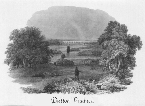
Completion of the Dutton Viaduct. On Friday, January 9, 1837, was performed the ceremony of laying the last, or key stone, of the magnificent viaduct across the Weaver, at Dutton. A party of the directors from Liverpool attended, and were met by Mr. Locke, the engineer, and the resident engineers and contractors on the line. Mr. Heyworth, as the senior director present, after placing the last stone in its bed, addressed the party. He congratulated the workmen (of whom about one hundred and fifty were present) on their steady perseverance and diligence in bringing to perfection so noble a work: he rejoiced to find, that, in the erection of this, the greatest and first structure of its kind in the kingdom, no life or limb had been sacrificed. Mr. Locke, the engineer, and the Rev. W. Stanhope, also addressed the meeting. The health of the workmen was then given by Mr. Locke, amid hearty cheers. In the evening, the viaduct was illuminated with torches, and fireworks were displayed in great abundance; during which time the workmen were regaled with a good dinner and excellent cheer.—Chester Courant.
The traveller who would enjoy glimpses of railroad views, must bear in mind the velocity of his conveyance, and prepare to “see whatever can be seen,” or the most important objects will have glanced by the windows of his comfortable locomotive arm-chair coach, before any second person can warn him of their presence. Emerging from a cutting, which immediately succeeds the viaduct, Dutton Hall is observed on the E. backed by wood. A short distance farther, a fine rear-view is obtained (only by outside passengers we fear) of the Weaver, the vale of Dutton, Cogshall Park beyond, and in the distance the range of Derbyshire Hills. Passing between Bird Wood and Dutton Wood, we reach the tunnel at Preston Brook, 110 yards in length, over which the Chester road passes.
Preston Brook Station.
Distance to Birmingham, 72½—Liverpool and Manchester, 25 miles.
DISTANCES BY ROADS FROM THIS STATION TO THE FOLLOWING PLACES:—
Places W. of Station.
Frodsham 3 miles.
Ince 9½ —
Plemondstall 10½ —
Thornton Le Moors 11½ —
Guilden Sutton 11½ —
Stoak or Stoke 12½ —
Chester 13 —
Backford 14 —
Preston, though a small place, is one of considerable traffic, from its vicinity to the salt districts, and to the Grand Trunk Canal.
Frodsham lies three miles W. of the line at this part; it has a market on Saturday, and fairs on May 15, and August 21. The principal branch of trade is salt refining, besides which, there are flour mills and cotton factories. This place is mentioned in Doomsday Book, as being the property of the Earl of Chester. The town, situated on an eminence on the banks of the Weaver, near its confluence with the Mersey, consists of a broad street, a mile in length; at the E. end is a bridge of four arches over the Weaver, and at the W. end anciently stood a Norman castle; another street leads to the Church, an ancient structure, partly in the Norman style of architecture.
Norton Priory, the residence of Sir Richard Brooke, Bart., is seen on the W. A religious establishment formerly existed here, some ancient parts of which are included in the present mansion. The Duke of Bridgewater’s canal runs through the park. In the rear of Norton Priory, as seen from the railway, is the now busy and important town of Runcorn, containing 10,326 inhabitants.
In 915, Ethelfleda, sister to King Edward the Elder, widow of Ethelred, King of Mercia, built a town and castle near the river Mersey, at this place, some traces of which are still visible. In 1133, William Fitz Nigel founded here a monastery of canons regular, which, in the reign of Stephen, was removed to Norton Priory above mentioned.
Runcorn is a place of considerable resort for bathing, and has been recently much enlarged, and improved by handsome buildings, &c. The township abounds with fine stone quarries, from which great quantities are sent by water to Liverpool, Manchester, &c. Here are extensive chemical and soap works, in connexion with which a chimney of 273 feet in height, and of great beauty, has recently been erected. The church is in the early and later styles of English architecture. Near Runcorn are the fine ruins of Halton Castle, situated on a steep eminence, and commanding an extensive and beautifully varied prospect, including the Mersey estuary, the Welsh mountains, and richly-wooded scenery in Cheshire and Lancashire. This fortress was demolished during the civil wars. Eastward, passing Keakwick, and Daresbury, where is a fine old church, The Elms appear. Passing which we arrive at
Moore Station.
Distance to Birmingham, 75—Liverpool and Manchester, 22½ miles.
DISTANCES BY ROADS FROM THIS STATION TO THE FOLLOWING PLACES:—
Places W. of Station. Places E. of Station.
Halton 3½ miles. Daresbury 1¼ mile.
Lower Runcorn 4 — Hatton 2¼ —
Higher Runcorn 4½ — Stretton 3¾ —
Weston 5 — Grappenhall 4½ —
The pretty village of Moore is not seen from the line. Richly-wooded country lies on either side the road now, and occasionally peeping through the trees, the masts of vessels passing on the Mersey may be observed. The Mersey Viaduct is next traversed. This, though far less grand in appearance than the Dutton Viaduct, is a fine erection of 200 yards in length, consisting of twelve arches, nine being small, and three of larger span, beneath which the river Mersey, and the Mersey and Irwell Canal pass. Shortly after leaving the viaduct the town of Warrington is seen on the E., and westward lies Penketh, and the small white buildings at Fiddler’s Ferry.
WARRINGTON STATION.
Distance to Birmingham, 78—Liverpool and Manchester, 19½ miles.
DISTANCES BY ROADS FROM THIS STATION TO THE FOLLOWING PLACES:—
Places E. of Station.
Grappenhall 3½ miles.
Lymm 5½ —
Warburton 8 —
Bowdon 11¾ —
Altringham 12 —
Warrington forms a pleasing view from the approaching trains.
It contains 19,155 inhabitants, and is by some writers supposed to have been originally a British town, and on the invasion of the Romans under Agricola, in 79, to have been converted into a Roman station. This supposition rests chiefly on the circumstances of three Roman roads tending hitherwards to a ford over the Mersey; the vestiges of a castrum and fosse, still discernable; and the discovery of Roman coins and other relics near the ford. On its occupation by the Saxons, it obtained the name of Weringtun, from Wæring, a fortification, and tun, a town. The river was passed by ford till 1496, when Thomas, first Earl of Derby, erected a stone bridge in compliment to Henry VII., when on his visit to Latham and Knowsley. In the reign of Henry VIII., Leland, speaking of Warrington, says, “It is a pavid towne of prety bignes, the paroche chirce is at the tayle of the towne; it is a better market than Manchestre.” In the civil wars of 1643, the Royalists of the place betook themselves to the church, which they fortified, but the Parliamentarian battery dislodged them from their military sanctuary. The town is pleasantly situated on the Mersey; the streets are chiefly narrow, but contain some good buildings.
Prior to the construction of the railroad between Liverpool and Manchester, seventy stage-coaches passed through Warrington daily; now only four run. The manufactures comprise muslin, calico, velveteen, sailcloth, (which was formerly the staple trade,) pins, files, hardware, glass, malt, soap, and ale of strength and quality renowned. Railways, rivers, and canals, facilitate trade materially. The market days are Wednesday and Saturday; the fairs commence July 18 and November 30, continuing ten days. There are cloth halls, and various public buildings, and a fine old church, dedicated to St. Helen; the architecture exhibits traces of various styles and periods. Two ancient sepulchral chapels remain, and contain some magnificent monuments of the Boteler, Massey, and Patten families. There are two other churches, and various dissenting chapels and meetings, Free Grammar School, Blue Coat School, and many others, also Hospitals and other excellent institutions.