PART II. (continued 2)
Reading edition
Reluctantly we returned to Floral pass for another load of camp supplies, and late in the afternoon pressed on to Blossom island, where we again pitched our tents in rain and mist, and again, when the storm cleared away, found ourselves in an untrodden paradise. Kerr and Christie rejoined us at Blossom island on July 31, and we were once more ready for an advance.
BLOSSOM ISLAND.
Our camp on Blossom island was near a small pond of water and close beside a thick grove of spruce trees on the western side of the land-mass. The tents were so placed as to secure an unobstructed view to the westward; and they were visible, in turn, to parties descending from the mountains toward the northwest, whither our work soon led us.
The sides of Blossom island are rough and precipitous. The glaciers flowing past it cut away the rocks and, as the surface of the ice-fields was lowered, left them in many places in rugged cliffs bare of vegetation. The top of the island was also formerly glaciated and in part covered with débris; but the ice retreated so long ago that the once desolate surface has become clothed in verdure. Everywhere there are dense growths of flowers, ferns and berry bushes. On the rocky spurs, thrifty spruce trees, festooned with drooping streamers, shelter luxuriant banks of mosses, lichens and ferns. There was no evidence that human hand had ever plucked a flower in that luxuriant garden; not a trace could be found of man's previous invasion. The only trails were those left by the bears in forcing their way through the dense vegetation in quest of succulent roots. Later in the season, when the berries ripened, there was a feast spread invitingly for all who chose to partake. On the warm summer days the air was filled with the perfume of the flowers, birds flitted in and out of the shady grove, and insects hummed in the glad sunlight; the freshness and beauty on every hand made this island seem a little Eden, preserved with all its freshness and fragrance from the destroying hand of man.
This oasis in a desert of ice is so beautiful and displays so many instructive and attractive features that I wish the reader to come with me up the flowery slopes and study the interesting pictures to be seen from its summit.
The narrow ravine back of our camp is festooned and overhung with tall ferns, shooting out from the thickets on either hand like bending plumes. You will notice at a glance, if perchance your youthful excursions happened to be in the northeastern states, as were mine, that many of the plants about us are old friends, or at least former acquaintances. The tall fern nodding so gracefully as we pass is an Asplenium, but of ranker growth than in most southern regions. These tall white flowers with aspiring, flat-topped umbels, looking like rank caraway plants, but larger and more showy, belong to the genus Archangelica, and are at home in the Cascade range and the Rocky Mountains as well as here. The lily-like plant growing so profusely, especially in the moist dells, with tall, slim spikes of greenish flowers and long parallel veined leaves, is Veratrum viride. These brilliant yellow monkey-flowers, bending so gracefully over the banks of the pond, are closely related to the little Mimulus which nods to its own golden reflection in many of the brooks of New England. That purple Epilobrum, with now and then a pure white variety, so common everywhere on these hills, is the same wanderer that we have seen over many square miles beneath the burnt woods of Maine. These bushes with obscure white flowers, looking like little waxen bells, we recognize at once as huckleberries; in a short time they will be loaded with luscious fruit. Inviting couches of moss beneath the spruce trees are festooned and decorated with fairy shapes of brown and green, that recall many a long ramble among the Adirondack hills and in the Canadian woods. The licapods, equiseta and ferns are many of them identical with the tracery on mossy mounds covering fallen hemlocks in the Otsego woods in New York, but display greater luxuriance and fresher and more brilliant colors. That graceful little beach-fern, here and there faded to a rich brown, foretelling of future changes, is identical with the little fairy form we used to gather long ago along the borders of the Great Lakes. Asters and gentians, delicate orchids and purple lupines, besides many less familiar plants, crowd the hillsides and deck the unkept meadows with a brilliant mass of varied light. In the full sunshine, the hill-slopes appear as if the fields of petals clothing them had the prism's power, and were spreading a web of rainbow tints over the lush leaves and grasses below.
On our return to Blossom island, late in September, we found many of the flowers faded, but in their places there was a profusion of berries nearly as brilliant in color as the petals that heralded their coming. Many of the thickets, inconspicuous before, had then a deep, rich yellow tint, due to an abundance of luscious salmon berries, larger than our largest blackberries. The huckleberries were also ripe, and in wonderful profusion. These additions to our table were especially appreciated after living for more than a month in the snow. The ash trees were holding aloft great bunches of scarlet berries, even deeper and richer in color than the ripe leaves on the same brilliant branches. The deep woods were brilliant with the broad yellow leaves of the Devil's club, above which rose spikes of crimson berries. The dense thickets of currant bushes, so luxuriant that it was difficult to force one's way through them, had received a dusky, smoke-like tint, due to abundant blue-black strings of fruit suspended all along the under sides of the branches.
Let us not look too far ahead, however. Wandering on over the sunny slopes, where the gardener has forgotten to separate the colors or to divide the flower banks, we gain the top of the island; but so dense are the plants about us, and so eager is each painted cup to expand freely in the sunlight at the expense of its neighbors, that we have to beat them down with our alpenstocks—much as we dislike to mar the beauty of the place—before we can recline on the thick turf beneath and study the strange landscape before us.
The foreground of every view is a bank of flowers nodding and swaying in the wind, but all beyond is a frozen desert. The ice-fields before us, with their dark bands of débris, are a picture of desolation. The creative breath has touched only the garden which we, the first of wanderers, have invaded. The land before us is entirely without human associations. No battles have there been fought, no kings have ruled, no poets have sung of its ruggedness, and no philosopher has explained its secrets. Yet it has its history, its poetry, and its philosophy!
The mountains toward the north are too near at hand to reveal their grandeur; only the borders of the vast snow-fields covering all of these upper slopes are in view. In the deep cañon with perpendicular walls, just north of our station, but curving westward so that its upper course is concealed from view, there flows a secondary glacier which forces its terminal moraine high up on the northern slope of Blossom island, but does not now join the ice-field on the south. Streams of turbid water flow from this glacier on each side of the oasis on which we stand and unite at the mouth of a dark tunnel in the ice toward the south.
The barren gravel plain just east of our station, and at the foot of the glacier from the north, is the bed of a glacial lake which has been drained through the tunnel in the ice. On our way to Blossom island we crossed this area and found that it had but recently lost its waters. Miniature terraces on the gravel banks forming the sides of the basin marked the height to which the waters last rose, and all the slopes formerly submerged were covered with a thin layer of sediment. On the sides of the basin where this fresh lining rests on steep slopes there are beautiful frettings made by rills in the soft sediment. The stream from the glacier now meanders across this sand plain, dividing as it goes into many branches, which unite on approaching the dark archway below. The lake is extremely irregular in its behavior, and may be filled and emptied several times in a season. The waters are either restrained or flow freely, according as the tunnel through which they discharge is obstructed or open. The lake is typical of a class. Similar basins may be found about many of the spurs projecting into the Malaspina glacier.
A little west of the glacier to which I have directed your attention there is a narrow mountain gorge occupied by another glacier, of small size but having all the principal characteristics of even the largest Alpine glaciers of the region. It is less than half a mile in length, has a high grade, and is fed by several lateral branches. Its surface is divided into an ice region below and a névé region above. It has lateral and medial moraines, ice pinnacles, crevasses, and many other details peculiar to glaciers. From its extremity, which is dark with dirt and stones, there flows a stream of turbid water. It is, in fact, a miniature similitude of the ice-streams on the neighboring mountain, some of which are forty or fifty miles in length and many times wider in their narrowest part than the little glacier before us is long. The more thoroughly we become acquainted with the mountains of southern Alaska the more interesting and more numerous do the Alpine glaciers of the third order become. Already, thousands could be enumerated.
I will not detain my imaginary companion longer with local details, but turn at once to the objects which will ever be the center of attraction to visitors who may chance to reach this remote island in the ice. Looking far up the Marvine glacier, beyond the tapering pinnacles and rugged peaks about its head, you will see spires and cathedral-like forms of the purest white projected against the northern sky. They recall at once the ecclesiastic architecture of the Old World; but instead of being dim and faded by time they seem built of immaculate marble. They have a grandeur and repose seen only in mountains of the first magnitude. The cathedral to the right, with the long roof-like crest and a tapering spire at its eastern terminus, is Mount Augusta; its elevation is over 13,000 feet. A little to the west, and equally beautiful but slightly less in elevation, is Mount Malaspina—a worthy monument to the unfortunate navigator whose name it bears. These peaks are on the main St. Elias range, but from our present point of view they form only the background of a magnificent picture. Later in the season our tents were pitched at their very bases, and they then revealed their full grandeur and fulfilled every promise given by distant views.
The rugged Hitchcock range bordering the distant margin of the Marvine glacier, like the mountains near at hand and the rocky island on which we stand, is composed of sandstone and shale, but presents one interesting feature, to which I shall direct your attention. The trend of the range is northeast and southwest, but the strata of which it is composed run east and west and are inclined northward. As the range is some eight miles long, these conditions would seem to indicate a thickness of many thousands of feet for the rocks of which it is composed; yet the beds were deposited in horizontal sheets of sand and mud of very late date, as will be shown farther on. But the great apparent thickness of the strata is deceptive: a nearer examination would reveal the fact that the rocks have been so greatly crushed that even a hand specimen can scarcely be broken off with fresh surfaces. More than this, the black shale, exhibiting the greatest amount of crushing, is usually in wedge-shaped masses, which, in some cases at least, are bordered by what are known as thrust planes, nearly coinciding with the bedding planes of the strata. The rocks have been fractured and crushed together in such a way as to pile fragments of the same layer on top of each other, and thus to increase greatly their apparent thickness. In the elevations before us the thrust planes are tipped northeastwardly, and it would seem that the force that produced them acted from that direction. The apparent thickness of the beds has thus been increased many times. What their original thickness was, it is not now possible to say. Similar indications of a lateral crushing in the rocks may be found in several of the mountain spurs between the Hitchcock range and Yakutat bay; but space will not permit me to follow this subject further.
Turning from the mountains, we direct our eyes seaward; but it is a sea of ice that meets our view and not the blue Pacific. Far as the eye can reach toward the west, toward the south, and toward the southeast there is nothing in view but a vast plateau of ice or barren débris fields resting on ice and concealing it from view. This is the Malaspina glacier.
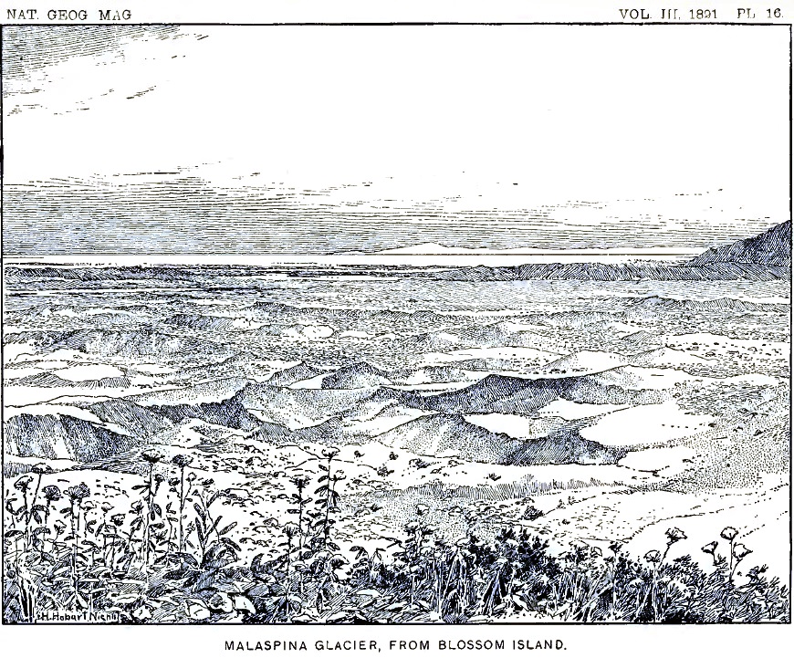
On the border of the ice, just below the cliffs on which we stand, there is a belt of débris perhaps five miles in breadth, which almost completely conceals the ice beneath. Portions of this moraine are covered by vegetation, and in places it is brilliant with flowers. The vegetation is most abundant on the nearer border and fades away toward the center of the glacier. Its distant border, adjacent to the white ice-field beyond, is absolutely bare and desolate. An attempt has been made to reproduce this scene in the picture forming plate 16. The drawing is from a photograph and shows the barren débris field stretching away towards the southwest. The extreme southern end of the Hitchcock range appears at the right. In the distance is the white ice of the central part of the Malaspina glacier. Far beyond, faintly outlined against the sky, are the snow-covered hills west of Icy bay. The flowers in the foreground are growing on the crest of the steep bluff bordering Blossom island on the south.
On the moraine-covered portion, especially where plants have taken root, there are hundreds, perhaps thousands, of lakelets occupying kettle-shaped depressions. A view of one of these interesting reservoirs in the ice is given in figure 2. If we should go down to the glacier and examine such a lakelet near at hand, we should find that the cliffs of ice surrounding them are usually unsymmetrical, being especially steep and rugged on one side and low or perhaps wanting entirely on the other. But there is no regularity in this respect; the steep slopes may face in any direction. On bright days the encircling walls are always dripping with water produced by the melting of the ice; little rills are constantly flowing down their sides and plunging in miniature cataracts into the lake below; the stones at the top of the ice-cliffs, belonging to the general sheet of débris covering the glacier, are continually being undermined and precipitated into the water. A curious fact in reference to the walls of the lakelets is that the melting of the ice below the surface is more rapid than above, where it is exposed to the direct rays of the sun. As a result the depressions have the form of an hour-glass, as indicated in the accompanying section.
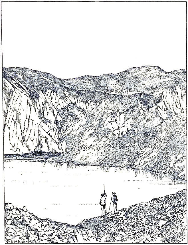
FIGURE 2—View of a glacial Lakelet (drawn from a Photograph).
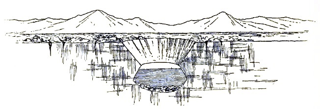
FIGURE 3—Section of a glacial lakelet.
Beyond the bordering moraines at our feet, we can look far out over the ice-plateau and view hundreds of square miles of its frozen surface. At the same time we obtain glimpses of other vast ice-fields toward the west, beyond Icy bay; but their limits in that direction are unknown.
Later in the season I made an excursion far out on the Malaspina glacier from the extreme southern end of the Hitchcock range, and became acquainted with many of its peculiarities. Its surface, instead of being a smooth snow-field, as it appears from a distance, is roughened by thousands of crevasses, many of which are filled with clear, blue water. Over hundreds of square miles the surface appears as if a giant plow had passed over it, leaving the ice furrowed with crevasses. The crevasses are not broad; usually one can cross them at a bound. They appear to be the scars left by rents in the tributary ice-streams.
The stillness far out on the great ice-field is immediately noticed by one who has recently traversed the sloping surfaces of the tributary glaciers. It is always silent on that vast frozen plateau. There are no surface streams and no lakes; not a rill murmurs along its channel of ice; no cascades are formed by streams plunging into moulins and crevasses. The water produced by the melting of the ice finds its way down into the glacier and perhaps to its bottom, and must there form rivers of large size; but no indications of their existence can be obtained at the surface. The icy surface is undulating, and resembles in some respects the great rolling prairies of the west; it is a prairie of ice. In the central portion not a shoot of vegetation casts its shadow, and scarcely a fragment of rock can be found. The boundaries of the vast plateau have never been surveyed, but its area cannot be less than five hundred square miles. The clear ice of the center greatly exceeds the extent of the moraine-covered borders. It has a general elevation of fifteen or sixteen hundred feet, being highest near the end of the Hitchcock range, where the Seward glacier comes in, and decreasing from there in all directions. From the summit of Blossom island and other commanding stations it is evident that the dark moraine belts about its borders are compound and record a varied history. Far away toward the southeast the individual elements may be distinguished. The dark bands of débris sweep around in great curves and concentric, swirl-like figures, which indicate that there are complicated currents in the seemingly motionless plateau.
The Malaspina glacier belongs to a class of ice bodies not previously recognized, which are formed at the bases of mountains by the union of several glaciers from above. Their position suggests the name of Piedmont glaciers for the type. They differ from continental glaciers in the fact that they are formed by the union of ice-streams and are not the sources from which ice-streams flow. The supply from the tributary glacier is counterbalanced by melting and evaporation.
If the reader has become interested in the vast ice-fields about Blossom island, he may wish to continue our acquaintance and go with me into the great snow-fields on the higher mountains, where the ice-rivers feeding the Malaspina glacier have their sources.
LIFE ABOVE THE SNOW-LINE.
Early on the morning of August 2, all necessary preparations having been made the day previous, we started in the direction of the great snow peak to be seen at the head of the Marvine glacier, where we hoped to find a pass leading through the mountains which would enable us to reach the foot of Mount St. Elias or to discover a practicable way across the main range into the unknown country toward the north.
All of the camp hands were with us at the start, except Stamy and White, who had been despatched to Port Mulgrave to purchase shoes. All but Crumback and Lindsley were to return to Blossom island, however, after leaving their loads at a rendezvous as far from Blossom island as could be reached in a day and allow sufficient time to return to the base-camp. Kerr and myself, with the two camp hands mentioned, were to press on to the snow-fields above. We took with us a tent, blankets, rations, an oil-stove, and a supply of coal oil, and felt equal to any emergency that might arise.
The morning of our departure was thick and foggy, with occasional showers, and the weather grew worse instead of better as we advanced. All the mountains were soon shut out from view by the vast vapor banks that settled down from above, and we had little except the general character of the glacier to guide us.
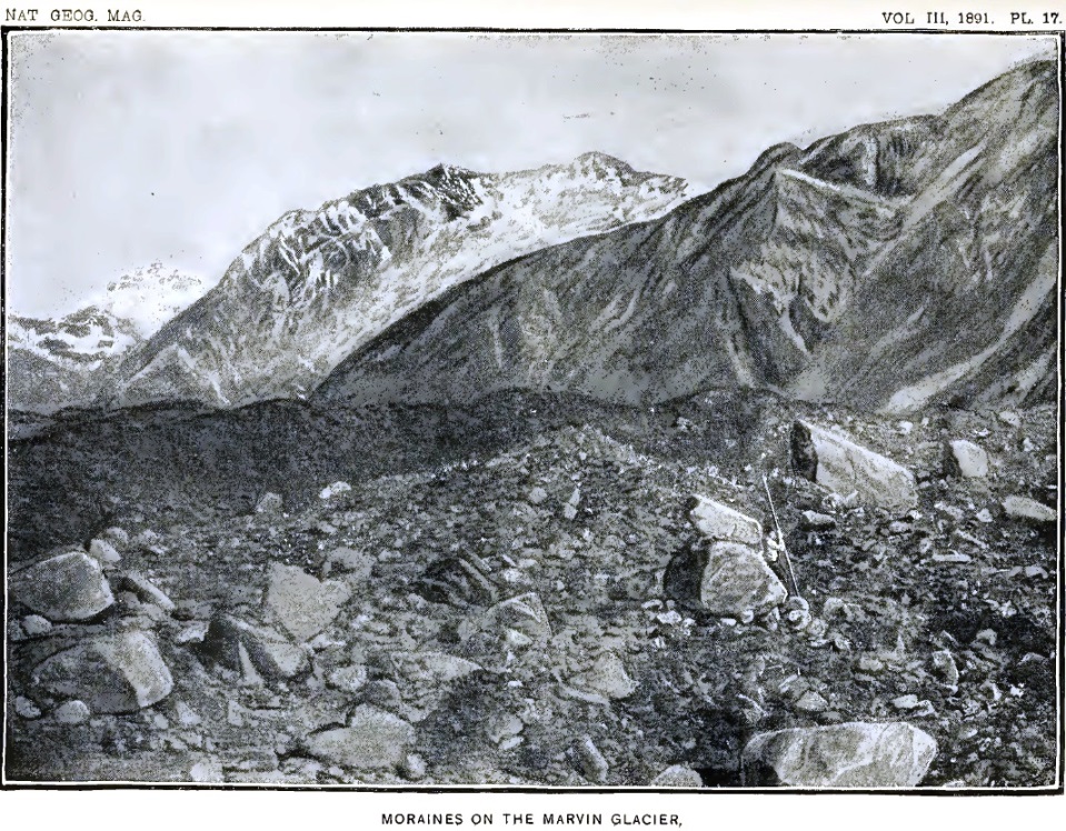
Our way at first led up the eastern border of the Marvine glacier, over seemingly interminable fields of angular débris. Traveling on the rugged moraine, some idea of which may be obtained from plate 17, was not only tiresome in the extreme, but ruinous to boots and shoes. On passing the mouth of the first lateral gorge (about a mile from Blossom island), from which flows a secondary glacier, we could look up the bed of the steep ravine to the white precipices beyond, which seemed to descend out of the clouds, and were scarred by avalanches; but all of the higher peaks were shrouded from view. At noon we passed the mouth of a second and larger gorge, which discharges an important tributary. We then left the border of the glacier and traveled up its center, the crevasses at the embouchures of the tributary stream being too numerous and too wide to be crossed without great difficulty.
In the center of the Marvine glacier there is a dark medial moraine, composed mainly of débris of gabbro and serpentine, of the same character as the medial moraine on the Hayden glacier, already briefly mentioned. Here, too, we found broad areas covered with sand cones and glacial tables. There are also rushing streams, flowing in channels of ice, which finally plunge into crevasses or in well-like moulins and send back a deep roar from the caverns beneath. The murmurs of running waters, heard on every hand, seem to indicate that the whole glacier is doomed to melt away in a single season.
Early in the afternoon we reached the junction of the two main branches of the Marvine glacier, and chose the most westerly. We were still traveling over hard blue ice in which the blue and white vein-structure characteristic of glaciers could be plainly distinguished. The borders of the ice-streams were dark with lateral moraines; but after passing the last great tributary coming in from the northeast we reached the upper limit of the glacier proper and came to the lower border of the névé fields, above which there is little surface débris. The glacier there flows over a rugged descent, and is greatly broken by its fall. At first we endeavored to find a passage up the center of the crevassed and pinnacled ice, but soon came to an impassable gulf. Turning toward the right, we traversed a ridge of ice between profound gorges and reached the base of the mountain slope bordering the glacier on the east. Our party was now divided; Christie and his companion were left searching for a convenient place to leave the cans of rations they carried, while we, who were to explore the regions above, were endeavoring to find a way up the ice-fall. A shout from our companions below called our attention to the fact that they were unable to reach the border of the glacier, where they had been directed to leave their packs, and that they had left them on the open ice. They waved us "good-bye" and started back toward Blossom island, leaving our little band of four to make the advance.
Descending into a deep black gorge at the border of the ice, formed by its melting back from the bordering cliffs, we clambered upward beneath overhanging ice-walls, from which stones and fragments of ice were occasionally dropping, and finally reached a great snow-bank on the border of the glacier. As the storm still continued, and was even increasing in force, we concluded to find a camping ground soon as possible and make ourselves comfortable as the circumstances would permit.
FIRST CAMP IN THE SNOW.
We had now reached the lower limit of perpetual snow. There were no more moraines on the surface of the glacier, and no bare rock surfaces large enough to hold a tent. The entire region was snow-mantled as far as the eye could see, except where pinnacles and cliffs too steep and rugged for the snow to accumulate rose above the general surface. A little to one side of the mouth of a steep lateral gorge we found a spot in which a mass of partly disintegrated shale had fallen down from the cliff. We scraped the fragments aside, smoothed the snow beneath, and built a wall of rock along the lower margin. The space above was filled in with fragments of shale, so as to form a shelf on which to pitch our tent. Soon our blankets were spread, with our water-proof coats for a substratum, and supper was prepared over the oil-stove.
Darkness settled down over the mountains, and the storm increased as the night came on. What is unusual in Alaska, the rain fell in torrents, as in the tropics. Our little tent of light cotton cloth afforded great protection, but the rain-drops beat on it with such force that the spray was driven through and made a fine rain within. Weary with many hours of hard traveling over moraines and across crevassed ice, and in an atmosphere saturated with moisture, we rolled ourselves in our blankets, determined to rest in spite of the storm that raged about.
As the rain became heavier, the avalanches, already alarmingly numerous, became more and more frequent: A crash like thunder, followed by the clatter of falling stones, told that many tons of ice and rocks on the mountains to the westward had slid down upon the borders of the glacier; another roar near at hand, caused by an avalanche on our own side of the glacier, was followed by another, another, and still another out in the darkness, no one could tell where. The wilder the storm, the louder and more frequent became the thunder of the avalanches. It seemed as if pandemonium reigned on the mountains. One might fancy that the evil spirits of the hills had prepared for us a reception of their own liking—but decidedly not to the taste of their visitors. Soon there was a clatter and whiz of stones at our door. Looking out I saw rocks as large as one's head bounding past within a few feet of our tent. The stones on the mountain side above had been loosened by the rain, and it was evident that our perch was no longer tenable. Before we could remove our frail shelter to a place of greater safety, a falling rock struck the alpenstock to which the ridge-rope of our tent was fastened and carried it away. Our tent "went by the board," as a sailor would say, and we were left exposed to the pouring rain. Before we could gather up our blankets they were not only soaked, but a bushel or more of mud and stones from the bank above, previously held back by the tent, flowed in upon them. Rolling up our blankets and "caching" the rations, instruments, etc., under a rubber cloth held down by rocks, we hastily dragged our tent-cloth down to the border of the glacier, at the extremity of a tapering ridge, along which it seemed impossible for stones from above to travel. We there pitched our tent on the hard snow, without the luxury of even a few handfuls of shale beneath our blankets. Wet and cold, we sought to wear the night away as best we could, sleep being impossible. Crumback, who had been especially energetic in removing the tent, regardless of his own exposure, was wet and became cold and silent. The oil-stove and a few rations were brought from the cache at the abandoned camp, and soon a dish of coffee was steaming and filling the tent with its delicious odor. Our shelter became comfortably warm and the hot coffee, acting as a stimulant, restored our sluggish circulation. We passed an uncomfortable night and watched anxiously for the dawn. Toward morning a cold wind swept down the glacier and the rain ceased. With the dawn there came indications that the storm had passed, although we were still enveloped in dense clouds and could not decide whether or not a favorable change in the weather had occurred. We were still cold and wet and the desire to return to Blossom island, where all was sunshine and summer, was great. Uncertain as to what would be the wisest course, we packed our blankets and started slowly down the mountain, looking anxiously for signs that the storm had really passed.
An hour after sunrise a rift in the mist above us revealed the wonderful blue of the heavens, and allowed a flood of sunlight to pour down upon the white fields beneath. Never was the August sun more welcome. The mists vanished before its magic touch, leaving here and there fleecy vapor-wreaths festooned along the mountain side; as the clouds disappeared, peak after peak came into view, and snow-domes and glaciers, never seen before, one by one revealed themselves to our astonished eyes. When the curtain was lifted we found ourselves in a new world, more wild and rugged than any we had yet beheld. There was not a tree in sight, and nothing to suggest green fields or flowery hill-sides, except on a few of the lower mountain spurs, where brilliant Alpine blossoms added a touch of color to the pale landscape. All else was stern, silent, motionless winter.
The glacier, clear and white, without a rock on its broken surface, looked from a little distance like a vast snow-covered meadow. We were about a mile above the lower limit of the snow-fields, where the blue ice of the glacier comes out from beneath the névé. The blue ice was deeply buried, and could only be seen in the deepest crevasses. Across the glacier rose the angular cliffs and tapering spires of the Hitchcock range. Every ravine and gulch in its rugged sides was occupied by glaciers, many of which were so broken and crevassed that they looked like frozen cataracts.
Cheered by the bright skies and sun-warmed air, we pushed on up the glacier, taking the center of the stream in order to avoid the crevasses, which were most numerous along its borders. Two or three miles above our first camp we found a place where a thin layer of broken shale covered the snow, at a sufficient distance from the steep slopes above to be out of the reach of avalanches. We there established our second camp after leaving Blossom island, dried our blankets, and spent the remainder of the day basking in the sunlight and gathering energy for coming emergencies.
We found the névé of the Marvine glacier differing greatly from the lower or icy portion previously traversed. Instead of ice with blue and white bands, as is common lower down, the entire surface, and as far down in the crevasses as the eye could distinguish, was composed of compact snow, or snow changed to icy particles resembling hail and having in reality but few of the properties of ordinary snow: it might properly be called névé ice. Usually the thickness of the layers varied from ten to fifteen feet. Separating them were dark lines formed by dust blown over the surface of the glacier and buried by subsequent snow-storms, or by thin blue lines formed by the edges of sheets of ice and showing that the snow surface had been melted during bright sunny days and frozen again at night. The horizontal stratification so plainly marked in all the crevasses in the névé was almost entirely wanting, or at least was not conspicuous, in the lower portion of the glacier, where, instead, we found those narrow blue and white bands already mentioned, the origin of which has been so well described and explained by Tyndall.
The center of the Marvine glacier, as in most similar ice-streams, is higher and less broken by crevasses than its borders. The crevasses at the side trend up stream, as is the case with marginal crevasses generally. In the present instance the courses of these rents could be plainly distinguished on each border of the glacier, when looking down upon it from neighboring slopes. The crevasses occur at quite regular intervals of approximately fifty feet, and diverge from the bank at angles of about 40°. In the banks of snow bordering the glacier similar crevasses diverge from the margin of the flowing glacier and trend down along its banks. The marginal crevasses and the crevasses in the bordering snow-fields, to which no special name has been given, fall nearly in line; but between the two there is a series of irregular cracks and broken snow, sharply defining the border of the moving névé.
The origin of the marginal crevasses trending up stream was explained during the study of the glaciers of Switzerland. The following diagram and explanation illustrating their development are copied from Tyndall:
"Let A C be one side of the glacier and B D the other; and let the direction of motion be that indicated by the arrow. Let S T be a transverse slice of the glacier, taken straight across it, say to-day. A few days or weeks hence the slice will have been carried down, and because the center moves more quickly than the sides it will not remain straight, but will bend into the form S' T'. Supposing T i to be a small square of the original slice near the side of the glacier; in the new position the square will be distorted to the lozenge-shaped figure T' i'. Fix your attention upon the diagonal T i of the square; in the lower position this diagonal, if the ice could stretch, would be lengthened to T' i'. But the ice does not stretch; it breaks, and we have a crevasse formed at right angles to T' i'. The mere inspection of the diagram will assure you that the crevasse will point obliquely upward."29
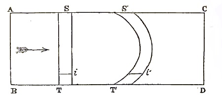
FIGURE 4—Diagram illustrating the Formation of marginal Crevasses.
29 The Forms of Water: International Scientific Series, New York, 1875, pp. 107–108.
The explanation given above applies especially to the lower or icy portion of a glacier; above the snow-line other facts appear. When a glacier flows through fields of snow on a level with its surface, crevasses are formed in the adjacent banks. These trend down stream for the same reason that the crevasses in the glacier proper trend up stream—that is, the friction of the moving stream against its banks tends to carry them along, while the portions at a distance are stationary. Fissures are thus opened which trend in the direction in which the glacier moves. The angle made by these crevasses with the axis of the glacier is about the same as those of the marginal crevasses, but in an opposite direction. They are widest near the margin of the glacier and taper to a sharp end towards the stationary snow-banks above. The crevasses in the two series thus fall nearly in line, but are separated by a narrow band of irregularly broken snow, marking the actual border of the glacier.29
30 Crevasses in snow-fields through which ice-streams flow will be mentioned again in describing the Seward glacier.
After leaving Blossom island the party was divided, and we began a new series of numbers for our camp above the snow-line, although in this narrative and on the accompanying map a single series of numbers for all the camps will be used. While in the field the camps in the snow were usually termed, facetiously, "sardine camps," in allusion to the uncomfortable manner in which we were packed in our tent at night.
ACROSS PINNACLE PASS.
The morning after reaching Camp 12 dawned gloriously bright. The night had been cold, and a heavy frost had silenced every rill from the snow-slopes above. The clear, bracing air gave us renewed energy and a firmer desire to press on. Mr. Kerr and myself made an excursion ahead, while Lindsley and Crumback brought up a load of supplies from the cache left on the glacier below Camp 11.
On gaining the center of the Marvine glacier we had a magnificent view down the broad ice-stream, bordered on either hand by towering, snow-laden precipices, and changing, as the eye followed the downward slope, from pure white to brown and black in the distance. Far below we could barely discern the wooded summit of Blossom island, beyond which stretched the seemingly limitless ice-fields of the Malaspina glacier. All about us the white slope reflected the sunlight with painful brilliancy, while the black moraines and forests below and the mists over the distant ocean, made it seem as if one was looking down into a lower and darker world.
As we advanced toward the head of the glacier we found, as on several subsequent occasions, that the nearer we approached the sources of an ice-stream the easier our progress became. Following up the center of the glacier, we learned that it curved toward the east; and after an hour or two of weary tramping we reached the great amphitheatre in which it has its source. All about us were rugged mountain slopes, heavily loaded with snow, and forming clear white cliffs from which avalanches had descended. To the westward the wall of the amphitheatre was broken, and it was apparent that we could cross its rim in that direction. Pressing onward up the gently ascending slope, we came at length to a gap in the mountains bordered on the north by a towering cliff fully a thousand feet high, and were rejoiced to find that the snow surface on the opposite side of the divide inclined westward with a grade as gentle as the one we had ascended. Looking far down the western snow-slope, we could see where it joined a large glacier flowing southward past the end of the great cliffs which extended westward from the divide. The glacier we saw in the valley below is designated on our map as the Seward glacier, in honor of William H. Seward, the former Secretary of State, who negotiated the purchase of Alaska for the United States.
The pass we named Pinnacle pass, on account of the many towering pinnacles overshadowing it. Its elevation is about four thousand feet, and at the summit it has a breadth of only two or three hundred feet. The snow on the divide is greatly crevassed, but a convenient snow-bridge enabled us to cross without difficulty. The crevasses increased in breadth with the advance of the season, and on returning from our mountain trip in September we had to climb up on the bordering cliff in order to pass the main crevasse at the summit. Some idea of the crevasses of this region may be obtained from the following figure, drawn from a photograph taken on the western side of Pinnacle pass, not far from the summit.
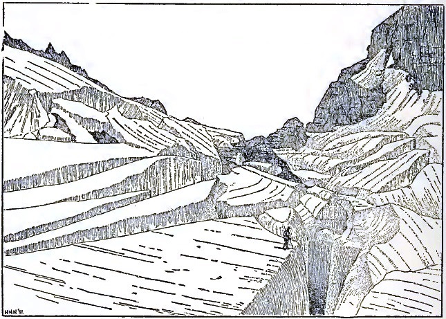
FIGURE 5—Crevasses on Pinnacle Pass; from a Photograph.
The cliff on the north of Pinnacle pass is really a huge fault-scarp of recent date, intersecting stratified shale, limestone, and conglomerate, with a few thin coal-seams. The strata dip toward the north at a high angle, and present their broken edges in the great cliff rising above the pass. The cliffs extend westward from the pass, and retain a nearly horizontal crest line, but increase in height and grandeur, owing to the downward grade of the glacier along their base. A mile to the westward their elevation is fully two thousand feet. The cliffs throughout are almost everywhere bare of snow and too steep and rugged to be scaled. They form a strongly drawn boundary line in the geology of the region, and furnish the key to the structure and geological character of an extended area. All the rocks to the southward are sandstone and shale belonging to a well-defined series, and differ materially from the rocks in the fault-scarp. I have called the rocks toward the south, the Yakutat system, and those exposed in the faces of the fault-scarp the Pinnacle system. Directly north of Pinnacle pass, and at the base of Mount Owen, the rocks of the Yakutat system are exposed, and from their position and association it is evident that they are younger than the Pinnacle system and belong above it. If these conclusions are sustained by future investigation, they will carry with them certain deductions which are among the most remarkable in geological history. On the crest of the Pinnacle pass cliffs I afterwards found strata containing fossil shells and leaves belonging to species still living. These records of animal and plant life show that not only were the rocks of the Pinnacle system deposited since living species of mollusks and plants came into existence, but that the Yakutat system is still more recent. More than this, the upheaval of the mountains, the formation of numerous fault-scarps, and the origin of the glaciers, have all occurred since Pliocene times.
The discovery of Pinnacle pass left no question as to the route to be traversed in order to reach the mountains to the westward. We returned to Camp 12, and the following day, with Crumback and Lindsley to assist us, advanced our camp across Pinnacle pass and far down the western snow-slope.
The day we crossed the pass was bright and clear in the morning, but clouds gathered around all the higher peaks about midday, vanishing again at nightfall. As it was desirable to occupy, for topographic and other purposes, a station on the top of the cliffs overlooking Pinnacle pass, we made an effort to reach the crest of the ridge by climbing up the steep scarp just at the divide, where the cliffs are lowest. While Crumback returned to Camp 12 for an additional load and Lindsley went ahead to discover a new camping place, Kerr and myself, taking the necessary instruments, began the ascent; but we found it exceedingly difficult. The outcrops of shale in the lower portion of the cliff furnished but poor foothold, and crumbled and broke away at every step. Once my companion, losing his support, slid slowly down the slope in spite of vigorous efforts to hold on, and a rapid descent in the yawning chasm below seemed inevitable, when, coming to a slightly rougher surface, he was able to control his movements and to regain what had been lost. Climbing on, we came to the base of a vertical wall of shale several hundred feet high, and made a detour to the left where a cascade plunged down a narrow channel. We ascended the bed of the stream, which was sometimes so steep that the spray dashed over us, and reached the base of an overhanging cliff of conglomerate composed of well-worn pebbles. Above this rose a cliff of snow fifty feet or more in height, which threatened to crash down in avalanches at any moment. One small avalanche did occur during the ascent, and scattered its spray in our faces. Had a heavy avalanche formed, our position would have been exceedingly dangerous; but by taking advantage of every overhanging ledge, and watching for the least sign of movement in the snow above, we reached without accident a sheltered perch underneath an overhanging cliff near the base of the snow. We then discovered that clouds were forming on all the high mountains, and shreds of vapor blown over the crest of the cliff above told us that further efforts would be useless. Seeking a perch protected from avalanches by an overhanging cliff, we had a splendid view far out over the sloping snow-plain toward the west and of the mountains bordering Pinnacle pass on the south. My notes written in this commanding station read as follows:
"Looking down from my perch I can plainly distinguish the undulations and crevasses in the broad snow-fields stretching westward from Pinnacle pass. Each inequality in the rock beneath the glacier is reproduced in flowing and subdued outlines in the white surface above. The positions of bosses and cliffs in the rock beneath are indicated by rounded domes and steep descents in the snow surface. About the lower sides of these inequalities there are in some cases concentric blue lines and in others radiating fissures, marking where the snow has broken in making the descent. The side light shining from the eastward down the long westerly slope reveals by its delicate shading the presence of broad, terrace-like, transverse steps into which the stream is divided. Were the snow removed and the rock beneath exposed, we should find broad terraces separated by scarps sweeping across the bed of the glacier from side to side. Similar terraces occur in glaciated cañons in the Rocky Mountains and the Sierra Nevada, but their origin has never been explained. The glacier is here at work sculpturing similar forms; but still it is impossible to understand how the process is initiated.
"Right in front of us, and only a mile or two away, rise the cliffs, spires, and pinnacles of the Hitchcock range. Every ravine and amphitheatre in the great mountain mass is deeply filled with snow, and the sharp angular crests look as if they had been thrust up through the general covering of white. The northern end of the range is clearly defined by the east-and-west fault to which Pinnacle pass owes its origin. The trend of the mighty cliffs on the southern face, on which we have found a perch, is at right angles to the longer axis of the Hitchcock range, and marks its northern terminus both topographically and geologically.
"There is not even a suggestion of vegetation in sight. The eye fails to detect a single dash of green or the glow of a single Alpine flower anywhere on the rugged slopes. A small avalanche from the snow-cliffs above, cascading over the cliff which shelters me and only a few yards away, tells why the precipices are so bare and desolate: they have been swept clean by avalanches.
"Far down the western snow-slope I can distinguish crevasses and dirt bands in the Seward glacier, which flows southward past the range on which we sit. The marginal crevasses along the border of the glacier can clearly be distinguished. As usual, they trend up-stream and, meeting medial crevasses, break the surface of the glacier into thousands of pinnacles and tables. Along the center of the stream there are V-shaped dirt bands, separated by crevasses, which point down-stream and give the appearance of a rapid flow to the central portion of the glacier. From this distance its center has the appearance of 'watered' ribbon.
"A little toward the south of where the medial crevasses are most numerous, and at a locality where two opposite mountain spurs force the ice-stream through the comparatively narrow gorge, there is evidently an ice-fall, as the whole glacier from side to side disappears from view. The appearance of Niagara when seen from the banks of the river above the Horseshoe falls is suggested. Beyond this silent cataract, the eye ranges far out over the broad, level surface of the Malaspina glacier, and traces the dark morainal ribbons streaming away for miles from the mountain spurs among which they originate. From the extreme southern cape of the Samovar hills there is a highly compound moraine-belt stretching away toward the south, and then dividing and curving both east and west. The central band of débris must be a mile broad. Along its eastern margin I can count five lesser bands separated by narrow intervals of ice, and on the farther side similar secondary bands are suggested, but the height of the central range almost completely conceals them from view. In the distant tattered ends, however, their various divisions can be clearly traced. Great swirls in the ice are there indicated by concentric curves of débris on its surface.
"Still farther westward there are hills rising to the height of impressive mountains, in which northward dipping rocks, apparently of sandstone and shale, similar to those forming the Hitchcock range, are plainly distinguishable. All the northern slopes of these hills are deeply buried beneath a universal covering of snow evidently hundreds of feet thick, which is molded upon them so as to reveal every swelling dome and ravine in their rugged sides. Farther westward still, beyond a dark headland apparently washed by the sea, there are other broad ice-fields of the same general character as the Malaspina glacier, which stretch away for miles and miles and blend in the dim distance with the haze of the horizon.
"Just west of the Seward glacier, and in part forming its western shore, there are dark, rocky crests projecting through the universal ice mantle, suggesting the lost mountains of Utah and Nevada which have become deeply buried by the dusts of the desert. The character of the sharp crests beyond the Seward glacier indicate that they are the upturned edges of fault-blocks similar to the one on which we are seated. Interesting geological records are there waiting an interpreter. The vastness of the mountains and the snow-fields to be seen at a single glance from this point of view can scarcely be realized. There are no familiar objects in sight with which to make eye-measurements; the picture is on so grand a scale that it defies imagination's grasp."
Searching the snow-sheet below with a field-glass, I discover a minute spot on the white surface. Its movement, slow but unmistakable, assures me that it is Lindsley returning from the site chosen for our camp to-night. Although apparently near at hand, he forms but an inconspicuous speck on the vast snow-field.
Having learned all that I could of the geology of the cliff, and the gathering clouds rendering it unnecessary to climb the summits above, we descended with even more difficulty than we had encountered on our way up, and met Lindsley as he reached the pass. Resuming our packs, we started on, knowing that Crumback would follow our trail; and after two hours' hard tramping over a snow surface rendered somewhat soft by the heat of the day, but fortunately little crevassed, we reached the place chosen for our camp. Crumback soon joined us, and we pitched our tent for the night. The place chosen was on a little island of débris, the farthest out we could discover from the base of the great cliff on the north. We judged that we should there be safe from avalanches, although the screech and hiss of stones falling from the cliff were heard many times during the night.
Lindsley and Crumback, on revisiting the site of our camp two days later, found that a tremendous avalanche of snow and rocks had in the mean time fallen from the cliffs and ploughed its way out upon the glacier to within fifteen or twenty feet of where we had passed the night. They remarked that if the avalanche had occurred while we were in camp, our tent would not have been reached, but that we should probably have been scared to death by the roar.
FIRST FULL VIEW OF ST. ELIAS.
Leaving Crumback and Lindsley to make our camp as comfortable as possible, Kerr and I pressed on with the object of seeing all we could of the country ahead before the afternoon sunlight faded into twilight. Mount St. Elias had been shut out from view, either by clouds or by intervening mountains, for several days; but it was evident that on approaching the end of the Pinnacle pass fault-scarp we should behold it again, and comparatively near at hand.
Continuing down the even snow-slope, in which there were but few crevasses, the view became broader and broader as we advanced, and at length the great pyramid forming the culminating summit of all the region burst into full view. What a glorious sight! The great mountain seemed higher and grander and more regularly proportioned than any peak I had ever beheld before. The white plain formed by the Seward glacier gave an even foreground, broken by crevasses which, lessening in perspective, gave distance to the foot-hills forming the western margin of the glacier. Far above the angular crest of the Samovar hills in the middle distance towered St. Elias, sharp and clear against the evening sky. Midway up the final slope a thin, horizontal bar of gray clouds was delicately penciled. Through the meshes of the fairy scarf shone the yellow sunset sky. The strong outlines of the rugged mountain, which had withstood centuries of storms and earthquakes, were softened and glorified by the breath of the summer winds, chilled as they kissed its crystal slopes.
Could I give to the reader a tithe of the impressions that such a view suggests, they would declare that painters had never shown them mountains, but only hills. So majestic was St. Elias, with the halo of the sunset about his brow, that other magnificent peaks now seen for the first time or more fully revealed than ever before, although worthy the respect and homage of the most experienced mountain-climber, scarcely received a second glance.
Returning to camp, we passed the night, and the following day, August 6, advanced our camp to the eastern border of the Seward glacier at the extreme western end of the upturned crest forming the northern wall of Pinnacle pass.
The western end of the Pinnacle pass cliff is turned abruptly northward, and the rocks dip eastward at a high angle, showing, together with other conditions, that the end of the ridge is determined by a cross-fault running northeast and southwest. West of the Seward glacier there is a continuation of the Pinnacle-pass cliff, but it is greatly out of line. The position of the Seward glacier, in this portion of its course, was determined by the fault which broke the alignment of the main displacement.
Many facts of similar nature show that the glaciers of the St. Elias region have had their courses determined, to a large extent, by the faults which have given the region its characteristic structure: the ice drainage is consequent to the structure of the underlying rocks; the glaciers not only did not originate the channels in which they flow, but have failed to greatly modify them.
Camp 14 was on a sharp crest of limestone, conglomerate, and shale belonging to the Pinnacle system, which was not over ten feet broad where our tent was pitched. East of our tent there was a broad, upward sloping snow-plain banked against the precipitous base of a hill about a thousand feet high. At the edge of the snow, within three feet of our tent, there was a pond of clear water, seemingly placed there for our special use. The western edge of our tent was at the margin of a cliff about a hundred feet high, overlooking the Seward glacier. We held this camp for several days and reöccupied it on our return from St. Elias.
SUMMIT OF PINNACLE PASS CLIFFS.
From Camp 14 Crumback returned to Blossom island, and Stamy took his place. Word from Christie assured me that supplies would be advanced to Blossom island, and that our cache on the Marvine glacier would be renewed. Stamy's arrival was especially welcome for the reason that he brought letters from dear ones far away, which had been forwarded from Sitka by a trading schooner that chanced to visit Yakutat bay.
While the camp hands were busy in bringing up fresh supplies, Kerr and I occupied two stations on the summit of the Pinnacle pass cliffs. One of these was on a butte at the western end of the ridge and just above our camp; the other was on the crest of the main line of cliffs almost directly above Pinnacle pass, at an elevation of 5,000 feet. Each of the stations embraced magnificent views, extending from the outer margin of the Malaspina glacier to the crest of the St. Elias range. The station on the butte near camp was occupied several times, and proved to be a most convenient and commanding point for study of the geography, geology, and distribution of glacier over a wide area. On account of the splendid view obtained from the top we named it Point Glorious. Its elevation is 3,500 feet.
One of the days on which we occupied Point Glorious was especially remarkable on account of the clearness and freshness of the air and the sharpness with which each peak and snow-crest stood out against the deep-blue heavens. We left our camp early in the morning, and spent several hours on the summit. On our way up we found several large patches of Alpine flowers and, under a tussock of moss, a soft, warm nest just abandoned by a mother ptarmigan with her brood of little ones. One hundred feet higher we came to the borders of the snow-field which covered all of the upper slopes except a narrow crest of sandstone at the top.
The Seward glacier, sweeping down from the northeast, curves about the base of Point Glorious and flows on southward. Its surface has the appearance of a wide frozen river. Toward the east of our station there was a broad, level-floored amphitheatre, bounded on the south by the cliffs of Pinnacle pass and on the east by long snow-slopes which stretch up the gorges in the side of Mount Cook. The amphitheatre opens toward the northwest, and discharges its accumulated snows into the Seward glacier. Beyond this, on the north, stood the great curtain-wall named the Corwin cliffs, west of which rose Mount Eaton, Mount Augusta, Mount Malaspina, and other giant summits of the main St. Elias range. Toward the west the view culminated in St. Elias itself, ruggedly outlined against the sky. As the reader will become more and more familiar with the magnificent scenery of the St. Elias region as we advance, it need not be described in detail at this time.
All day the skies were clear and bright, giving abundant opportunity for making a detailed survey of the principal features in view, and for reading the history written in cliffs and glaciers. When the long summer day drew to a close, we returned to our tent and watched the great peaks become dim and generalized in outline as the twilight deepened. The fading light caused the mountains to recede farther and farther, until at last they seemed ghostly giants, too far away to be definitely recognized. With the twilight came soft, gray, uncertain clouds drawn slowly and silently about the rugged precipices by the summer winds from the sea. St. Elias became enveloped in luminous clouds, with the exception of a few hundred feet of the shining summit; and a glory in the sky, to the left of the veiled Saint, marked the place where the sun went down. The shadows crept across the snow-fields and changed them from dazzling white to a soft gray-blue. Night came on silently, and with but little change. There was no folding of wings; no twittering of birds in leafy branches; no sighing of winds among rustling leaves. All was stern and wild and still; there was not a touch of life to relieve the desolation. A midwinter night in inhabited lands was never more solemn. Man had never rested there before.
The air grew chill when the shadows crossed our tent, and delicate ice crystals began to shoot on the still surface of our little pond. We bade good night to the stern peaks, about which there were signs of a coming storm, and sought the shelter of our tent. Small and comfortless as was that shelter, it shut out the wintry scene and afforded a welcome retreat. Sound, refreshing sleep, with dreams of loved ones far away, renewed our strength for another advance.
The next day, August 8, a topographic station was occupied on the summit of the Pinnacle pass cliffs. We were astir before sunrise, and had breakfast over before four o'clock. The morning was cold, and a cutting wind swept down the Seward glacier from the northeast. All of the mountains were lost to view in dense clouds. A few rays of sunshine breaking through the vapor banks above Point Glorious gave promise of better weather during the day. Lindsley and Stamy had not yet returned from the lower camp, where they were to obtain additional rations; and Kerr and I concluded to try to reach the crest of the Pinnacle pass cliffs and take the chances of the weather being favorable for our work.
Leaving camp in the early morning light, we chose to climb over the summit of Point Glorious rather than thread the crevasses at its northern base. Reaching the top of the point, we were still beneath the low canopy of clouds, and could see far up the great amphitheatre to the base of Mount Owen.31 Descending the eastern slope, we soon reached the floor of the amphitheatre, and found the snow smooth and hard and not greatly crevassed. Cheered by faint promise of blue skies, we pressed on rapidly, the snow creaking beneath our tread as on a winter morning. Two or three hours of rapid walking brought us to the southern wall of the amphitheatre, nearly beneath the point we wished to occupy. As we ascended the slope the way became more difficult, owing not only to its steepness but also to the fact that the snow was softening, and also because great crevasses crossed our path. Looking back over the snow we had crossed, two well-characterized features on its surface could be distinguished: these were large areas with a gray tint, caused by a covering of dust. This dust comes from the southern faces of the Pinnacle pass cliffs, and is blown over the crest of the ridge and scattered far and wide over the snow-fields toward the north. Should the dust-covered areas become buried beneath fresh snow, it is evident that the strata of snow would be separated by thin layers of darker color. This is what has happened many times, as we could see by looking down into the crevasses. In one deep gulf I counted five distinct strata of clear white snow, separated by narrow dust-bands. In other instances there are twenty or more such strata visible. Each layer is evidently the record of a snow-storm, while the dust-bands indicate intervals of fine weather. The strata of snow exposed to view in the crevasses, after being greatly compressed, are usually from ten to fifteen feet thick, but in one instance exceeded fifty feet. If we assume that each layer represents a winter's snow, and that compression has reduced each stratum to a third of its original thickness (and probably the compression has been greater than this), it is evident that the fresh snows must sometimes reach the depth of from 50 to 150 feet.
31 Named for David Dale Owen, United States geologist.
Toiling on up the snow-slope, we had to wind in and out among deep crevasses, sometimes crossing them by narrow snow-bridges, and again jumping them and plunging our alpenstocks deep in the snow when we reached the farther side. After many windings we reached the summit of the Pinnacle-pass cliffs. The crest-line is formed of an outcrop of conglomerate composed of sand and pebbles, in one layer of which I found large quantities of mussel shells standing in the position in which the creatures lived. The present elevation of this ancient sea-bottom is 5,000 feet. The strata incline northward at angles of 30° to 40°. All of the northern slope of the ridge is deeply covered with snow, and the rock only appears along the immediate crest. There are, in fact, two crests, as is common with many mountain ridges in this region, one of rock and the second of snow; the snow crest, which is usually the higher, is parallel to the rock crest and a few rods north of it. In the valley between the two ridges we found secure footing, and ascended with ease to the highest point on the cliffs. Looking over the southern or rocky crest, we found a sheer descent of about 1,500 feet to the snow-fields below.
The clouds diminished in density and gradually broke away, so that the entire extent of the St. Elias range was in view, with the exception of the crowning peak of all, which was still veiled from base to summit. A spur of St. Elias, extending southward from the main peak, and named The Chariot, gleamed brightly in the sunlight. It was the first point on which we made observations. Stretching eastward from St. Elias is the sharp crest of the main range, on which stand Mounts Newton, Jeannette, Malaspina, Augusta, Logan, and several other splendid peaks not yet named. Just to the right of Mount Augusta, on the immediate border of the Seward glacier, rise the Corwin cliffs, marking an immense fault-scarp of the same general character as the one on which we stood.
Mr. Kerr endeavored at first to occupy a station on the crest of the rocky ridge, but as the steepness of the slope and the shattered condition of the rock rendered the station hazardous, the snow-ridge, which was covered with dust and sand and nearly as firm as rock, was occupied instead. The clouds parting toward the northeast revealed several giant peaks not before seen, some of which seem to rival in height St. Elias itself. One stranger, rising in three white domes far above the clouds, was especially magnificent. As this was probably the first time its summit was ever seen, we took the liberty of giving it a name. It will appear on our maps as Mount Logan, in honor of Sir William E. Logan, founder and long director of the Geological Survey of Canada.
The clouds grew denser in the east, and shut off all hope of extending the map-work in that direction. While Kerr was making topographic sketches I tried to decipher some of the geological history of the region around me and make myself more familiar with its glaciers and snow-fields.
Even more remarkable than the mighty peaks toward the north, beheld that day for the first time, was the vast plateau of ice stretching seaward from the foot of the mountains. From my station what seemed to be the ocean's shore near Icy bay could just be distinguished. Beyond the bay there is a group of hills which come boldly down to the sea, and apparently form a sea-cliff at the water's edge. Beyond this headland there is another vast glacier extending westward to the limits of vision. The view from this point is essentially the same as that obtained from the cliffs at Pinnacle pass a few days earlier, except that it is far more extended. It need not be described in detail.
The clouds becoming thicker and settling in dark masses about the mountains, we gave up all hope of further work and started for our camp. On the way down the ridge between the crest of snow and the crest of rock we found a stratum of sandstone filled with fossil leaves, and near at hand another layer charged with very recent sea-shells. Collecting all of these that we could carry, we trudged on, finding the snow soft and some of the bridges which we had easily crossed in the morning now weak, trembling, and insecure. We crossed them safely, however, and, reaching the level floor of the amphitheatre, marched wearily on toward Point Glorious. This time we passed along the northern base of the butte at an elevation of two or three hundred feet above the glacier, and, taking a convenient slide down the snow-slope, reached our tent.
Soon a delicious cup of coffee was prepared, bacon was fried, and these were put in a warm place while some griddle cakes were being baked. A warm supper, followed by a restful pipe, ended the day. Kerr and I were our own cooks and our own housekeepers during much of the time we lived above the snow-line. We cleared away the remains of the supper, and prepared our blankets for the night. One of the huge ice pinnacles on the glacier fell with a great crash just as we were turning in. Rain began to fall, and the night was cold and disagreeable; how it passed I do not know, as I slept soundly. Scarcely anything less serious than the blowing away of our tent could have awakened me.
ACROSS SEWARD GLACIER TO DOME PASS.
Stormy weather and the necessity of bringing additional supplies from Blossom island detained us at Camp 14 until August 13. We rose at three o'clock on the morning of that day, and, after a hasty breakfast, prepared to cross the Seward glacier. The morning was cold but clear, and the air was bracing. Each peak and mountain crest in the rugged landscape stood out boldly in the early light, although the sun had not risen. Soon the summit of St. Elias became tipped with gold, and then peak after peak, in order of their rank, caught the radiance, and in a short time the vast snow-fields were of dazzling splendor.
The frost of the night before had hardened the snow, which made walking a pleasure. We crossed a rocky spur projecting northward from Point Glorious into the Seward glacier, and had to lower our packs down the side of the precipice with the aid of ropes. Our course led at first up the border of the great glacier to a point above the head of the rapids already referred to, then curved to the westward, and for a mile or two coincided with the general trend of the crevasses. We made good progress, but at length we came to where the Augusta glacier pours its flood of ice into the main stream and, owing to its high grade, is greatly broken. Skirting this difficult area, we passed a number of small blue lakelets and reached the western border of the Seward glacier. We found a gently rising snow-slope leading westward through a gap that could be seen in hills a few miles in advance. But little difficulty was now experienced, except that the snow had become soft under the summer's sun, and walking over it with heavy loads was wearisome in the extreme. We could see, however, that the way ahead was clear, and that encouraged us to push on. Toward night we found a camping place on a steep ridge of shale and sandstone projecting eastward from a spur of Mount Malaspina. This ridge rises about five hundred feet above the surrounding glacier, and has steep roof-like slopes. The summer sun had melted nearly all the snow from its southern face, but the northern slope was still heavily loaded. The snow on the northern side stood some thirty or forty feet higher than the rocky crest of the ridge itself, and between the rock crest and the snow crest there was a little valley which afforded ample shelter for our tent and was quite safe from avalanches. The melting of the snow-bank during the warm days supplied us with water.
The formation of crests of snow standing high above the rocky ridges on which they rest is a peculiar and interesting feature of the mountains of the St. Elias region. A north-and-south section through the ridge on which Camp 15 was situated, exhibiting the double crests, one of rock and the other of snow, is shown at a in figure 6. b is a section through a similar ridge with a still higher snow crest. The remaining figures in the illustration are sketches of mountain peaks, as seen from the south, which have been increased in height by a heavy accumulation of snow on their northern slopes. These sketches are of peaks among the foothills of Mount Malaspina, and show snow pinnacles from fifty to more than a hundred feet high. In some instances, domes and crests of snow were seen along the western sides of the ridges and peaks, but as a rule these snow-tips on the mountains are confined to their northern slopes. The edges and summits of the snow-ridges are sharply defined and clearly cut. The southern slope exposed above the crest of rock is often concave, while the northern slopes are usually convex.

FIGURE 6—Snow Crests on Ridges and Peaks; from Field Sketches.
In climbing steep ridges the double crests are frequently of great assistance. Safe footing may frequently be found in the channels between the crests of rock and snow, by the aid of which very precipitous peaks may be climbed with ease. In case the ascent between the two crests is not practicable, the even snow-slope itself affords a sure footing for one used to mountain climbing.
After establishing Camp 15, Lindsley and Stamy returned to one of the lower camps for additional supplies, while Kerr and I explored a way for farther advance.
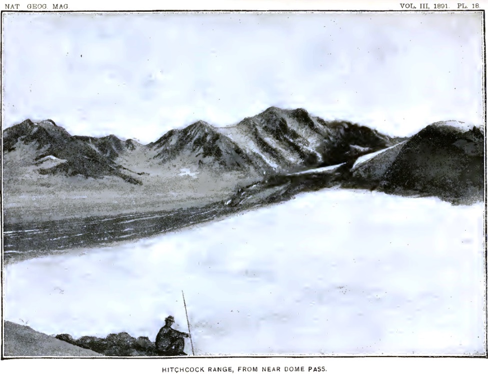
Our camp occupied a commanding situation. From the end of the ridge on which it was located there was a splendid view of glaciers and mountains to the eastward. The illustration forming plate 18 is from a photograph taken from that station. Toward the north, and only a few miles away, rose the bare, rugged slope of Mount Malaspina. In a wild, high-grade gorge on its western side, a glacier, all pinnacles and crevasses, tumbles down into the broad white plain below. On account of its splendid ice-fall this was named the Cascade glacier. Beyond the white plain, stretching eastward for fifteen or twenty miles, there rise the foothills of Mount Cook. Farther south, the rugged, angular summits of the Hitchcock range are in full view, and toward the north stands Mount Irving,32 which rivals even Mount Cook in the symmetrical proportions of its snow-covered slopes.
32 Named in honor of Professor Roland Duer Irving, U. S. geologist.
The surface of the vast snow-plain near at hand is gashed by many gaping fissures, but the distance is so great that these minor details disappear in a general view. Looking down over the snow, one may see the crevasses as in a diagram. They look as if the white surface had been gashed with a sharp knife, and then stretched in such a way as to open the cuts. That the snow of the névés may be stretched, at least to a limited extent, is shown by the character of these fissures. The crevasses are widest in the center and come to a point at their curving extremities. Two crevasses frequently overlap at their ends and leave a sliver of ice stretching across diagonally between them. It is by means of these diagonal bridges that one is enabled to thread his way through the crevasses.
On returning to camp in the evening, weary with a hard day's climb, a never-failing source of delight was found in the matchless winter landscape to the eastward. The evenings following days of uninterrupted sunshine were especially delightful. The blue shadows of the western peaks creeping across the shining surface were nearly as sharp in outline as the peaks that cast them. When the chill of evening made itself felt, and the dropping water and the indefinite murmurs from the glacier below were stilled, the silence became oppressive. The stillness was so profound that it seemed as though the footsteps of the advancing shadows should be audible.
On warm sunny days, however, there are noises enough amid the mountains. The snow, partially melted and softened by the heat, falls from the cliffs in avalanches that make the mountains tremble and, with a roar like thunder, awaken the echoes far and near. During our stay at Camp 15 the avalanches were sometimes so frequent on the steep mountain faces toward the north that the roar of one falling mass of snow and rocks was scarcely hushed before it was succeeded by another.
On the southward-facing cliffs of Mount Augusta, composed of schist which disintegrates rapidly, there are frequent rock avalanches. A rock or a mass of comminuted schist sometimes breaks away even in midday, although these avalanches occur most frequently when the moisture in the rocks freezes. The midday avalanches, I fancy, may be started by the expansion of the rocks owing to the sun's heat. A few stones dislodged high up on the cliffs fall, and, loosening others in their descent, soon set in motion a train of dirt and stones, which flows down the steep ravines with a long rumbling roar, at the same time sending clouds of dust into the air. If the wind is blowing up the cliffs, as frequently happens on warm days, the dust is carried far above the mountains, and hangs in the air like clouds of smoke.
It has been frequently stated that St. Elias is a volcano, and sea captains sailing on the Pacific have seen what they supposed to be smoke issuing from its summit. As its southern face is composed of the same kind of rocks and is of the same precipitous nature as the southern slope of Mount Augusta, it appears probable that what was supposed to be volcanic smoke was in reality avalanche dust blown upward by ascending air currents.
The disintegration of the mountain summits all through the St. Elias region is so great that one constantly wonders that anything is left; yet, except late in the fall, the snow surfaces at the bases of even the steepest cliffs are mostly bare of débris. The absence of earth and stones on the surfaces of the névé fields is mainly due, of course, to the fact that these are regions of accumulation where the winter's snow exceeds the summer's melting. Thus each year the surface is renewed and made fresh and clean, and any débris that may have previously accumulated is concealed.
There is another reason, however, why but little débris is found at the bases of the steep precipices. The snows of winter are banked high against these walls, but when the rocks are warmed by the return of the summer's sun the snow near their dark surfaces is melted, and leaves a deep gulf between the upward-sloping banks of snow and the sides of the cliffs. These black chasms are frequently 150 or 200 feet deep, and receive all the débris that falls from above. In this way very large quantities of earth and stones are injected, as it were, into the glacier, and only come to light again far down toward the ends of the ice-streams, where the summer's melting exceeds the winter's supply.
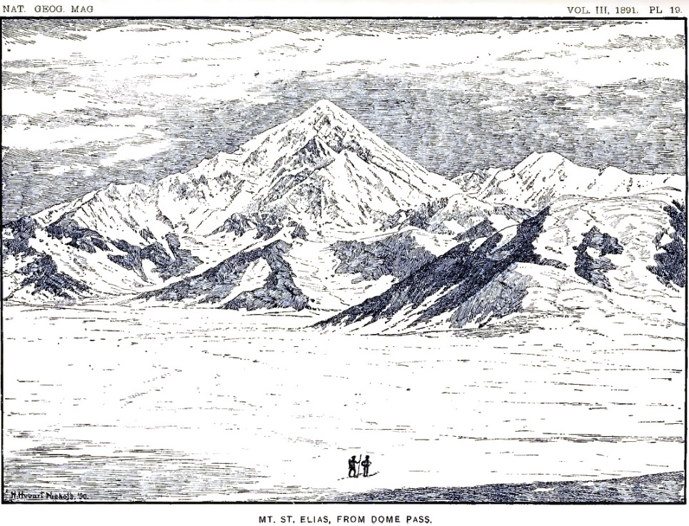
On August 14, Kerr and I made an excursion ahead to the border of the Agassiz glacier. The snow-slope south of our camp led westward up a gentle grade to a gap in the hills between two bold, snow-covered domes. The gap through which the snow extended, uniting with a broad snow-field sloping westward, was only a few hundred feet wide, and formed a typical mountain pass, designated on our map as Dome pass. Its elevation is 4,300 feet. When near the summit of the pass a few steps carried us past the divide of snow, and revealed to our eager eyes the wonderland beyond. St. Elias rose majestically before us, unobstructed by intervening hills, and bare of clouds from base to summit. We were greatly encouraged by the prospect ahead, as there were evidently no obstacles between us and the actual base of the mountain. A photograph of the magnificent peak was taken, from which the illustration forming plate 19 has been drawn. To the right of the main mountain mass, as shown in the illustration, rises Mount Newton,33 one of the many separate mountain peaks crowning the crest of the St. Elias range. Our way led down the snow-slope in the foreground to the border of the Agassiz glacier, which comes in view between the foot-hills in the middle distance and the sculptured base on which the crowning pyramid of St. Elias stands. After reaching the Agassiz glacier we turned to the right, and made our way to the amphitheatre lying between Mount St. Elias and Mount Newton. On the day we discovered Dome pass, we pressed on down the western snow-slope and reached the side of the Agassiz glacier, which we found greatly crevassed; selecting a camping place on a rocky spur, we returned to Camp 15, and two days later established camp at the place chosen.
33 Named for Henry Newton, formerly of the School of Mines of Columbia college and author of a report on the geology of the Black hills of Dakota.
Camp 16 was similar in many ways to Camp 14. It had about the same altitude; it was at the western end of a rugged mountain spur, and on the immediate border of a large southward-flowing glacier. On the lower portions of the cliffs, near at hand, there were velvety patches of brilliant Alpine flowers mingled with thick bunches of wiry grass and clumps of delicate ferns. Most conspicuous of all the showy plants, so bright and lovely in the vast wilderness of snow, were the purple lupines. Already the flowers on the lower portions of their spikes had matured, and pods covered with a thick coating of wooly hairs were beginning to be conspicuous. There are no bees and butterflies in these isolated gardens, but brown flies with long-pointed wings were abundant. A gray bird, a little larger than a sparrow, was seen flitting in and out of crevasses near the border of the ice, apparently in quest of insects. Once, while stretched at full length on the flowery carpet enjoying the warm sunlight, a humming bird flashed past me. Occasionally the hoarse cries of ravens were heard among the cliffs, but they seldom ventured near enough to be seen. These few suggestions were all there was to remind us of the summer fields and shady forests in far-away lands.
UP THE AGASSIZ GLACIER.
From Camp 16 Kerr and I made an excursion across the Agassiz glacier, while Stamy and Lindsley returned to a lower camp for additional supplies. We found the glacier greatly crevassed and the way across more difficult than on any of the ice-fields we had previously traversed; but by dint of perseverance, and after many changes in our course, we succeeded at last in reaching the western bank, and saw that by climbing a precipice bordering an ice-cascade we could gain a plateau above, which we knew from previous observations to be comparatively little broken. We returned to camp, and on August 18 began the ascent of the glacier in earnest. We were favored in the task by brilliant weather.
After reaching the western bank of the glacier, we made our way to the base of the precipice up which we had previously wished to climb. In order to reach it, however, we had to throw our packs across a crevasse over which there was no bridge, and followed them by jumping. The side of the crevasse from which we sprang was higher than its opposite lip, and left us very uncertain as to how we were to return; but that was a matter for the future; our aim at the time was to ascend the glacier, and the return was of no immediate concern.
Reaching the base of the cliff at the side of the glacier, we ascended it without great difficulty, and came out upon the broad plateau of snow above. Thinking that the way onward would be easier along the steep snow-slope bordering the glacier, we made an effort to ascend in that direction, and spent two or three precious hours in trying to find a practicable route. Although the crevasses were fewer than on the glacier proper, yet they were of larger size and had but few bridges. At last we came to a wide gulf on the opposite side of which there was a perpendicular wall of snow a hundred feet high, and all further advance in that direction was stopped. Although obliged to turn back, our elevated position commanded a good view of the glacier below and enabled us to choose a way through the maze of crevasses crossing it. Descending, we plodded wearily on in an irregular zigzag course; but the crevasses became broader and deeper as we advanced, and at length we found ourselves traversing flat table-like blocks of snow, bounded on all sides by crevasses so deep that their bottoms were lost to view. We made our way from one snow-table to another by jumping the crevasses where they were narrowest, or by frail snow-bridges spanning the profound gulfs. Night came on while we were yet in this wild, broken region, and no choice was left us but to pitch our tent in the snow and wait until morning. The night was clear and cold, and a firm crust formed on the snow before morning. Although the temperature was uncomfortable, we were cheered by the prospects of a firm snow surface on the morrow.
We continued our march at sunrise and found the walking easy; but the sun soon came out with unusual brilliancy and softened the snow so much that even the slowest movements were fatiguing. We endeavored to force our way up the center of the glacier through the crevasses and pinnacles of a second ice-fall; but after several hours of exhausting experience we were obliged to change our plan, and endeavored to reach a mountain spur projecting from the western border of the glacier. The sunlight reflected from the snow was extremely brilliant, and the glare from every surface about us was painful to our eyes, already weakened by many days' travel over the white snow. Each member of the party was provided with colored glasses, but in traversing snow-bridges and jumping crevasses these had to be dispensed with. The result was that all of us were suffering more or less from snow-blindness.
About noon we reached the base of the mountain spur toward which our course was bent. It projects into the western border of Agassiz glacier. It is the extension of this cliff underneath the glacier that caused the ice-fall which blocked our way. To go round the end of the cliff with our packs was impracticable, but there seemed a way up the face of the cliff itself, which one could scale by taking advantage of the joints in the rocks. I ascended the snow-slope to the base of the precipice, but found the way upward more difficult than anticipated; and, as the light was very painful to my eyes when not protected by colored glasses, I decided to postpone making the climb until I was in better condition, and in the meantime to see if some other route could not be found. We decided to camp on a small patch of débris near the base of the cliff, and there left our loads. Kerr and Lindsley, taking a rope and alpenstocks, went around the end of the rocky spur and worked their way upward with great difficulty to the top of the cliff immediately above where I had essayed to climb it. A rope was made fast at the top, and our way onward was secured. This place was afterward called Rope cliff. The remainder of the afternoon I rested in the tent, with my eyes bound up with tea-leaves, and when evening came found the pain in my head much relieved.
Our tent that night was so near the brink of a crevasse that in order to stay the tent one end of the ridge-rope was made fast to a large stone, which was lowered into the gulf to serve as a stake. Above us rose a precipice nearly a thousand feet high, from which stones were constantly falling; but a deep black gulf intervened between the position we had chosen and the base of the cliffs, and into this the stones were precipitated. Not one of the falling fragments reached the edge of the snow slope on which we were camped, but many times during the night we heard the whiz and hum of the rocks as they shot down from the cliffs. The noise made by each fragment in its passage through the air increased rapidly in pitch, thus indicating that they were approaching us; but they always fell short of our camp. The bombardment from above was most active just after the shadows fell on the cliffs, showing that the stones were loosened by the freezing of the water in the interstices of the rock.
The next day, August 20, Stamy and Lindsley went back to Camp 16 for more rations, while Kerr and I remained at Camp 18 nursing our eyes and resting. The day passed without anything worthy of note, except the almost constant thunder of avalanches on the mountains. About sunset a dense fog spread over the wintry landscape and threatened to delay the return of the men. When the sun went down, however, the temperature fell several degrees, the mist vanished, and a few stars came out clear and bright. Just as we were about to despair of seeing the men that night we heard a distant shout announcing their return. We had a cup of hot coffee for them when they reached the tent, which they drank with eagerness; but they were too tired to partake of food. Rolling themselves in their blankets, they were asleep in a few minutes.
CAMP ON THE NEWTON GLACIER.
On August 21 we climbed the cliff above Camp 18 by means of the rope already placed there, and found the snow above greatly crevassed. We traveled upward along the steep slope bordering the glacier, but soon came to a deep crevasse which forbade further progress in that direction. Returning to a lower level, we undertook to smooth off an extremely narrow snow-bridge so as to make it wide enough to cross, but found the undertaking so hazardous that we abandoned it. By this time it was midday, and we prepared a cup of hot coffee before renewing our attack on the cliffs. After luncheon and a short rest, feeling very much refreshed, we began to cut a series of steps in a bluff of snow about fifty feet high, and made rapid progress in the undertaking. After an hour's hard work one of us reached the top and, planting an alpenstock deep in the snow, lowered a rope to those below. The packs were drawn up one at a time and we were soon ready to advance again.
We found ourselves in a vast amphitheatre bounded on all sides excepting that from which we had come with rugged, snow-covered precipices. The plain was crossed by huge crevasses, some of which were fully a mile in length; but by traveling around their ends or crossing snow-bridges we slowly worked our way onward toward St. Elias. Threading our way through the labyrinth of yawning gulfs, we at last, after the sun had gone down behind the great pyramid toward the west, found a convenient place on the snow, near a blue pond of water, on which to pass the night. Everything was snow-covered in the vast landscape except the most precipitous cliffs, and these were dangerous to approach, owing to the avalanches that frequently fell from them. The weather continued fine. The night was clear and the stars were unusually brilliant. Everything seemed favorable for pushing on. The way ahead presented such even snow-slopes and seemed so free from crevasses that we decided to leave our tent and blankets in the morning and, taking with us as little as possible of impedimenta, endeavor to reach the summit of St. Elias.
HIGHEST POINT REACHED.
Rising at three o'clock on the morning of August 22, we started for the summit of St. Elias, taking with us only our water-proof coats, some food, and the necessary instruments. The higher mountain summits were no longer clearly defined, but in the early light it was impossible to tell whether or not the day was to be fair. From the highest and sharpest peaks, cloud banners were streaming off towards the southeast, showing that the higher air currents were in rapid movement. Vapor banks in the east were flushed with long streamers of light as the sun rose, but soon faded to a dull ashen gray, while the cloud banners between us and the sun became brilliant like the halo seen around the moon when the sky is covered with fleecy clouds. This was the first time in my experience that I had seen colored banners waving from the mountain tops.
We found the snow-surface hard, and made rapid headway up the glacier. Our only difficulty was the uncertainty of the early light, which rendered it impossible to tell the slope of the uneven snow-surfaces. The light was so evenly diffused that there were no shadows. The rare beauty of that silent, wintry landscape, so delicate in its pearly half tones and so softly lighted, was unreal and fairy-like. The winds were still; but strange forebodings of coming changes filled the air. Long, waving threads of vapor were woven in lace-work across the sky; the white-robed mountains were partially concealed by cloud-masses drifting like spirits along their mighty battlements; and far, far above, from the topmost pinnacles, irised banners were signaling the coming of a storm.
We made rapid progress, but early in the day came to the base of a heavy cloud bank which enshrouded all the upper part of St. Elias. Then snow began to fall, and it was evident that to proceed farther would be rash and without promise of success. After twenty days of fatigue and hardship since leaving Blossom island, with our goal almost reached, we were obliged to turn back. Hoping to be able to renew the attempt after the storm had passed, Mr. Kerr left his instruments on the snow between two huge crevasses and we returned to our tent, where we passed the remainder of the day and the night following. The snow continued to fall throughout the day, and the storm increased in force as night came on. When we awoke in the morning the tempest was still raging. We were in the midst of the storm-cloud; the dense vapor and the fine drifting snow-crystals swept along by the wind obscured everything from view; the white snow surface could not be distinguished from the vapor-filled air; there was no earth and no sky; we seemed to be suspended in a white, translucent medium which surrounded us like a shroud. The snow was already more than three feet deep about our tent, and to remain longer with the short supply of provisions on hand was exceedingly hazardous, as there seemed no limit to the duration of the storm. A can of rations had been left at Rope cliff, and we decided to return to that place if possible. Resuming our packs, we roped ourselves together and began to descend through the blinding mist and snow which rendered the atmosphere so dense that a man could not be distinguished at a distance of a hundred feet. With only an occasional glimpse of the white cliff around to guide us, we worked our way downward over snow-bridges and between the crevasses. Our ascent through this dangerous region had been slow and difficult, but our descent was still more tedious. All day long we continued to creep slowly along through the blinding storm, and as night approached believed ourselves near the steps cut in a snow-cliff during the ascent, but darkness came before we reached them. Shoveling the snow away as best we could with our hands and basins, we cleared a place down to the old snow large enough for our tent and went into camp.