NATIONAL GEOGRAPHIC MAGAZINE.
Reading edition
AN EXPEDITION TO MOUNT ST. ELIAS, ALASKA
BY ISRAEL C. RUSSELL.
(Accepted for publication March 18, 1891.)
CONTENTS.
Introduction—The Southern Coast of Alaska
Part I—Previous Explorations in the St. Elias Region Bering, 1741 Cook, 1778 La Pérouse, 1786 Dixon, 1787 Douglas, 1788 Malaspina, 1792 Vancouver, 1794 Belcher, 1837 Tebenkof, 1852 United States Coast and Geodetic Survey, 1874, 1880 New York Times Expedition, 1886 Topham Expedition, 1888
Part II—Narrative of the St. Elias Expedition of 1890 Organization From Seattle to Sitka From Sitka to Yakutat Bay Canoe Trip up Yakutat Bay Base Camp on the Shore of Yakutat Bay First Day's Tramp Canoe Trip in Disenchantment Bay From Yakutat Bay to Blossom Island Blossom Island Life above the Snow-Line First Camp in the Snow Across Pinnacle Pass First full View of St. Elias Summit of Pinnacle Pass Cliffs Across Seward Glacier to Dome Pass Up the Agassiz Glacier Camp on the Newton Glacier Highest Point reached Alone in the highest Camp The Return Suggestions
Part III—Sketch of the Geology of the St. Elias Region General Features Yakutat System Pinnacle System St. Elias Schist Geological Structure
Part IV—Glaciers of the St. Elias Region Natural Divisions of Glaciers Alpine Glaciers Characteristics of Alpine Glaciers above the Snow-Line Characteristics of Alpine Glaciers below the Show-Line Piedmont Glaciers
Part V—Height and Position of Mount St. Elias
Appendix A—Official Instructions governing the Expedition
Appendix B—Report on topographic Work; by Mark B. Kerr
Appendix C—Report on auriferous Sands from Yakutat Bay; by J. Stanley-Brown
Appendix D—Report on fossil Plants; by Lester F. Ward
Index
ILLUSTRATIONS.
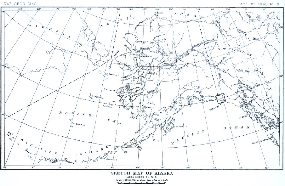
Plate 2—Sketch Map of Alaska 3—Map of the St. Elias Region, after La Pérouse 4—Map of the Eastern Shore of Yakutat Bay, after Dixon 5—Map of the St. Elias Region, after Malaspina 6—Map of Bay de Monti, after Malaspina 7—Map of Disenchantment Bay, after Malaspina 8—Sketch Map of St. Elias Region, by Mark B. Kerr 9—The Hubbard Glacier; drawn from Photograph by A. L. Broadbent 10—Wall of Ice on Eastern Side of the Atrevida Glacier; from a Photograph 11—View on the Atrevida Glacier; from a Photograph 12—Entrance of an Ice-Tunnel; from a Photograph 13—Deltas in an Abandoned Lake-Bed; from a Photograph 14—A River on the Lucia Glacier; from a Photograph (reproduced from The Century, April, 1891) 15—Entrance to a Glacial Tunnel; from a Photograph 16—View of the Malaspina Glacier from Blossom Island; from a Photograph 17—Moraines on the Marvine Glacier; from a Photograph 18—View of the Hitchcock Range from near Dome Pass 19—View of Mount St. Elias from Dome Pass; drawn from a Photograph 20—View of Mount St. Elias from Seward Glacier; drawn from a Photograph
Figure 1—Diagram illustrating the Formation of Icebergs 2—View of a glacial Lakelet; from a Photograph 3—Section of a glacial Lakelet 4—Diagram illustrating the Formation of marginal Crevasses 5—Crevasses near Pinnacle Pass; from a Photograph 6—Snow Crests on Ridges and Peaks; from Field Sketches 7—Faulted Pebble from Pinnacle Pass 8—Faulted Pebble from Pinnacle Pass
INTRODUCTION.
THE SOUTHERN COAST OF ALASKA.
The southern coast of Alaska is remarkable for the regularity of its general outline. If a circle a thousand miles in diameter be inscribed on a map of the northern Pacific with a point in about latitude 54° and longitude 145° as a center, a large part of its northern periphery will be found to coincide with the southern shore of Alaska between Dixon entrance on the east and the Alaska peninsula on the west. On the northern part of this great coast-circle lies the region explored in the summer of 1890 and described in the following pages.
From Cross sound, at the northern end of the great system of islands forming southeastern Alaska, westward along the base of the Fairweather range, the mountains are exceedingly rugged, and present some of the finest coast scenery in the world. There are but two inlets east of Yakutat bay on this shore which afford shelter even for small boats. These are Lituya bay and Dry bay. Ships may enter Lituya bay, at certain stages of the tide, and find a safe harbor within; but the approaches to Dry bay are not navigable. West of Yakutat bay the coast is equally inhospitable all the way to Prince William sound.
As if to compensate for the lack of refuge on either end, there is in the center of this great stretch of rock-bound coast, over 300 miles in extent, a magnificent inlet known as Yakutat bay, in which a thousand ships could find safe anchorage. On some old maps this bay is designated as "Baie de Monti," "Admiralty bay" and "Bering bay," as will be seen when its discovery and history are discussed on another page.
The southern shore of Alaska, for a distance of 200 miles along the bases of the Fairweather and St. Elias ranges, is formed of a low table-land intervening between the mountains and the sea. Yakutat bay is the only bight in this plateau sufficiently deep to reach the mountain to the northward. This bay has a broad opening to the sea; the distance between its ocean capes is twenty miles, and its extension inland is about the same. Its eastern shore is fringed with low, wooded islands, among which are sheltered harbors, safe from every wind that blows. The most accessible of these is Port Mulgrave, near its entrance on the eastern side.
The shores of Yakutat bay, on both the east and the west, are low and densely wooded for a distance of twenty-five miles from the ocean, where the foot-hills of the mountains begin. At the head of the bay the land rises in steep bluffs and forms picturesque mountains, snow-capped the year round. These highlands, although truly mountainous in their proportions, are but the foot-hills of still nobler uplifts immediately northward. The bay extends through an opening in the first range to the base of the white peaks beyond. This opening was examined a century ago by explorers in search of the delusive "Northwest passage," in the hope that it would lead to the long-sought "Strait of Annan"—the dream of many voyagers. It was surveyed by the expedition in command of Malaspina in 1792, and on account of his frustrated hopes was named "Puerto del Desengaño," or "Disenchantment bay," as it has been rendered by English writers.
The waters of Yakutat and Disenchantment bays are deep, and broken only by islands and reefs along their eastern shores. A few soundings made in Disenchantment bay within half a mile of the land showed a depth of from 40 to 120 fathoms. The swell of the ocean is felt up to the very head of the inlet, indicating, as was remarked to me by Captain C. L. Hooper, that there are no bars or reefs to break the force of the incoming swells.
The lowlands bordering Yakutat bay on the southeast are composed of assorted glacial débris. Much of the country is low and swampy, and is reported to contain numerous lakelets. Northwest of the bay the plateau is higher than toward the southeast, and has a general elevation of about 500 feet at a distance of a mile from the shore; but the height increases toward the interior, where a general elevation of 1,500 feet is attained over large areas. All of this plateau, excepting a narrow fringe along the shore, is formed by a great glacier, belonging to what is termed in this paper the Piedmont type. There are many reasons for believing that the plateau southeast of Yakutat bay was at one time covered by a glacier similar to the one now existing on the northwest.1
1 This matter will be discussed in part IV of this paper, where it is also shown that Yakutat bay itself was formerly occupied by glacial ice.
The mountains on the northern border of the seaward-stretching table-lands, both southeast and northwest of Yakutat bay, are abrupt and present steep southward-facing bluffs. This escarpment is formed of stratified sandstones and shales, and owes its origin to the upheaval of the rocks along a line of fracture. In other words, it is a gigantic fault scarp. The gravel and bowlders forming the plateau extending oceanward have been accumulating on a depressed orographic block (or mass of strata moved as a unit by mountain-making forces), which has undergone some movement in very recent times, as is recorded by a terrace on the fault scarp bordering it. West of Yakutat the geological structure is more complex, and long mountain spurs project into the platform of ice skirting the ocean. Filling the valleys between the mountain spurs, there are many large seaward-flowing glaciers, tributary to the great Piedmont ice-sheet.
This brief sketch of the geography of Yakutat bay, together with the accompanying outline map of Alaska (plate 2), will, it is hoped, aid in making intelligible the following historical sketch and the narrative of the present expedition.