Diagrams and Tables. (continued 3)
Reading edition
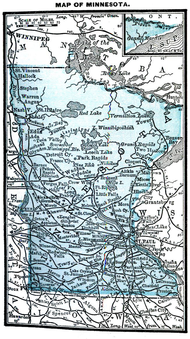
Population, 1,118,486: male, 605,551; female, 512,935: native, 733,320; foreign, 381,340: white, 1,115,358; colored, 1,814; Chinese, 99: Indians, 1,215.
State, congressional and presidential elections, Tuesday after first Monday in November; number Senators, 47; Representatives, 103; sessions of legislature biennial, in odd-numbered years, meeting Tuesday after first Monday in January; limit of session, 60 days; term of Senators, 4 years; of Representatives, 2 years.
Number electoral votes, 7; number voters, 306,435; idiots, insane and convicts excluded from voting.
Number colleges, 5; school population, 400,000; school age, 5-21.
Legal interest rate, 7; by contract, 10; usury forfeits excess over 10 per cent.
DAKOTA.Da-kō´ta.
So called from a tribe of Indians of the same name.
First permanent white settlements made by Lord Selkirk at Pembina, 1812; organized as a Territory, 1861; first legislature at Yankton, March, 1862.
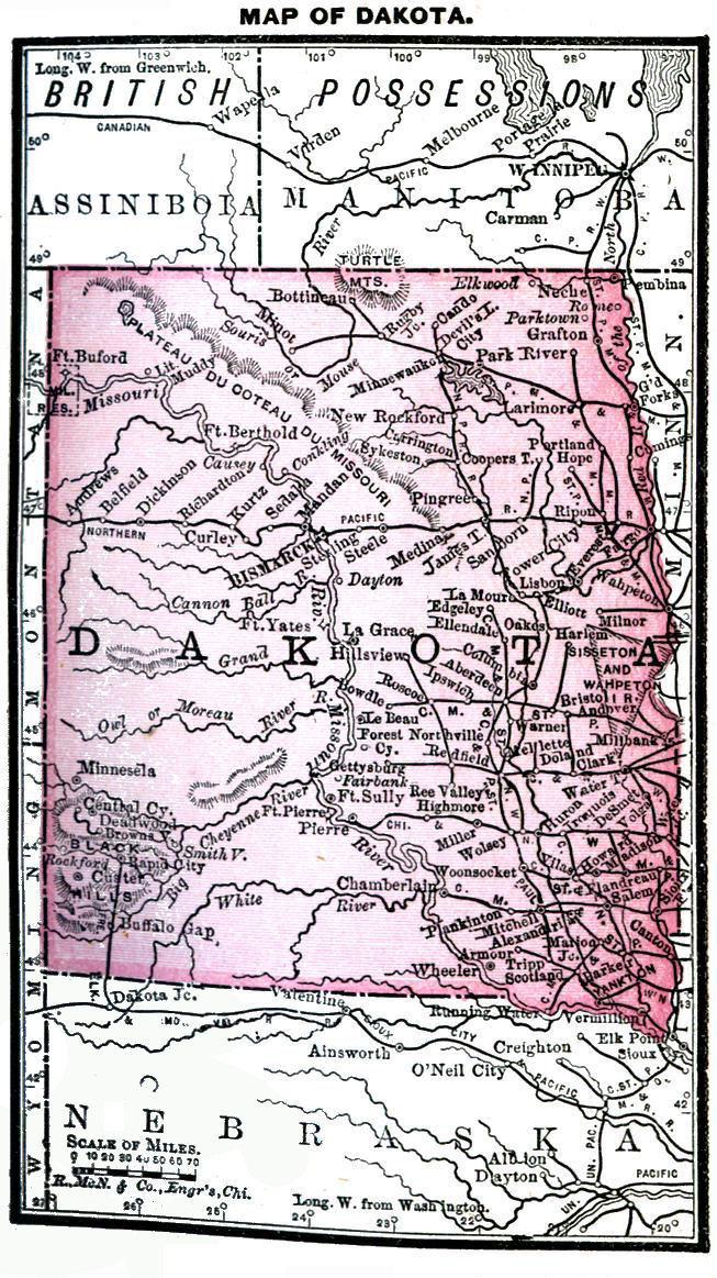
Area, 149,100 square miles; average length, 450 miles; breadth, 350 miles; ranks in size next to Texas and California. General elevation, 1,000 to 2,500 feet; Red river frontage, about 250 miles; the Missouri navigable throughout the Territory. Number counties, 136.
Temperature at Bismarck: winter, 4° to 27°; summer, 63° to 71°. Climate dry, and cold not so penetrating as in moister regions further east. Rainfall at Fort Randall, 17 inches; 73 per cent. of year's rain falls in spring and summer.
Fargo, the metropolis of Northern Dakota, an enterprising city, does a large business; has gas, electric lights, and street railway. Bismarck, capital, rapidly developing into an important business centre. Yankton, chief town of the south. Land offices at Fargo, Bismarck, Huron, Deadwood, Yankton, Mitchell, Aberdeen, Watertown and Grand Forks. Railway mileage, 1870, 65; 1884, 2,494. The Northern Pacific has a mileage of 375, crossing the northern central portion from Fargo through Bismarck in an almost direct westerly line through the Territory.
Salaries of State Officers. Governor $2,600 Secr'y of Terri'y 1,800 Treasurer 2,000 Auditor 1,000 Supt. Pub. Inst. 1,500 Chief Justice 3,000 5 Asso. Justices 3,000 Senators, Representatives $4 a day; mileage, 20c. 10 Indian Agents 1,000 to 2,200 Surveyor Gen. 2,500 Chief Clerk. 1,800 Chf. Draftsman 1,500 Assistant" 1,200 Col. Int. Rev. 2,750 4 Dep. Colls. 1,600 Presidential P. O. Aberdeen $1,900 Bismarck 2,200 Deadwood 1,800 Fargo 2,700 Grafton 1,600 Grand Forks 2,300 Huron 2,300 Jamestown 2,000 Mitchell 1,700 Pierre 1,800 Sioux Falls 2,200 Wahpeton 1,600 Watertown 1,700 Yankton 1,900 5 Post Offices 1,500 5"" 1,400 3"" 1,300 16"" 1,200 to 1,000

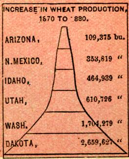
Finest wheat-growing country on the continent; corn crop, 1884, 13,950,000 bu.; oats, 11,812,000; wheat, 22,330,000 bu.; 2,800,000 bu. reported as freighted over Northern Pacific in four months of 1883, 76 per cent. being of best grade. Oats yield 50 to 75 bu. per acre; potatoes yield well and are of great size. Nutritious grasses at all seasons and abundant water offer remarkable advantages for stock raising; wool growing an important industry; climate especially favorable for sheep. Ranks fourth in gold, and ninth in silver; latest reported gold product, $4,123,081; mineral wealth centred in Black Hills; coal found in workable quantities west of the Missouri.
Population, 135,177 in 1880, with sufficient increase since then to entitle her to admission as a State: male, 82,296; female, 52,881; native, 83,382; foreign, 51,795; white, 133,147; colored, 401; Chinese, 238; Indians, 1,391.
Territorial, congressional and presidential elections, Tuesday after first Monday in November; number Senators, 12; Representatives, 24; sessions biennial, in odd-numbered years, meeting 2d Tuesday in January; limit session, 60 days; terms of Senators and Representatives, 2 years each. Number voters, census 1880, 51,003.
Legal interest rate, 7; by contract, 12; usury forfeits excess.
NEBRASKA.Ne-bras´ka.
Name first applied to the river, and is of Indian origin, signifying Shallow Water. Organized as a Territory, 1854; admitted 1867.
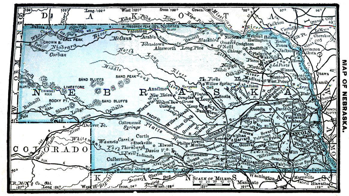
Area, 76,855 square miles; width, north and south, about 210 miles; greatest length in centre, about 420 miles. Platte, the principal river, extending through the State east and west. Number counties, 80.
Temperature at Omaha: winter, 20° to 34°; summer, 72° to 78°. Rainfall, Fort Kearney, 25 inches.
Omaha, U. S. port of delivery, principal city and commercial centre; population, 61,835. Lincoln, a thriving city, containing State University; population, 1870, 2,441, and 1885, 20,004. Population Plattsmouth, 5,796; of Nebraska City, 5,597.
Number farms, 63,387. Average value per acre, cleared land, $8.93; woodland, $25.85.
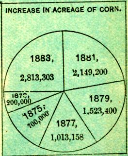
Corn crop, 1884, 122,100,000 bushels; wheat, 28,325,000 bushels; oats, 21,630,000 bushels. Rye, buckwheat, barley, flax and hemp yield abundant crops. Apples, pears, plums, grapes and berries are plentiful. Ranks eighth in corn and barley, and ninth in rye.
Salaries of State Officers. Governor $2,500 Lieut. Gov. $6 a day Sec'y of State 2,000 Aud'r Pub. Ac'ts 2,500 Attorney Gen. 2,000 Supt. Pub. Ins. 2,000 Sec'y Bd. Agr. 1,000 Com'r Pub. L'ds 2,000 Chief Justice 2,500 Senators, Representatives $3 a day; mileage, 10 cents. District Judge 3,500 Col. Int. Rev. 4,500 Surveyor Gen. 2,000 3 Indian Agents 1,200 to 1,600 Presidential P. O. Beatrice $2,100 Columbus 1,700 Crete 1,700 Falls City 1,600 Fremont 2,200 Grand Island 1,900 Hastings 2,100 Kearney 2,000 Lincoln 2,900 Nebraska City 2,100 Norfolk 1,300 Omaha 3,300 Plattsmouth 1,800 Seward 1,700 Tecumseh 1,600 Wahoo 1,600 York 1,700 10 P.O. $1,500 & 1,400 24 P.O. 1,200 to 1,000
Herd law excellent, and grazing land good. Cattle raising the great industry of the State, next to agriculture.
Manufacturing establishments show a wonderful increase of from 670 in 1870 to 1,403 in 1880. Capital invested, $4,881,150; number hands employed, 4,773.
Homesteads obtained under timber claims or by pre-emptions; cash expense of first, $18 to $36; of second, $14. U.S. land offices at Dakota City, Norfolk, Grand Island, Lincoln, Beatrice, Bloomington and North Platte.
Population, 452,402: male, 249,241; female, 203,161; native, 354,988; foreign, 97,414; white, 449,764; colored, 2,385; Chinese, 18; Indians, 235.
State, congressional and presidential elections, Tuesday after first Monday in November; number Senators, 33; Representatives, 100; sessions biennial, in odd-numbered years, meeting first Tuesday in January; limit of session, 40 days; terms of Senators and Representatives, 2 years each. Number electoral votes, 5; number voters, 129,042. U.S. army, idiots and convicts excluded from voting.
Number colleges, 9; school population, 135,511; school age, 5-21.
Legal interest, 7; by contract, 10; usury forfeits interest and cost.
Railroad mileage, 1865, 122; 1885, 2,891.
KANSAS. Kăn´zas. "Garden of the West."
From Kansas river. Indian name, signifying "Smoky Water". Visited by Spaniards, 1541, and by French, 1719. Part of Louisiana purchase, and afterward of Indian Territory. Organized as a Territory, 1854. Admitted as a State, January, 1861.
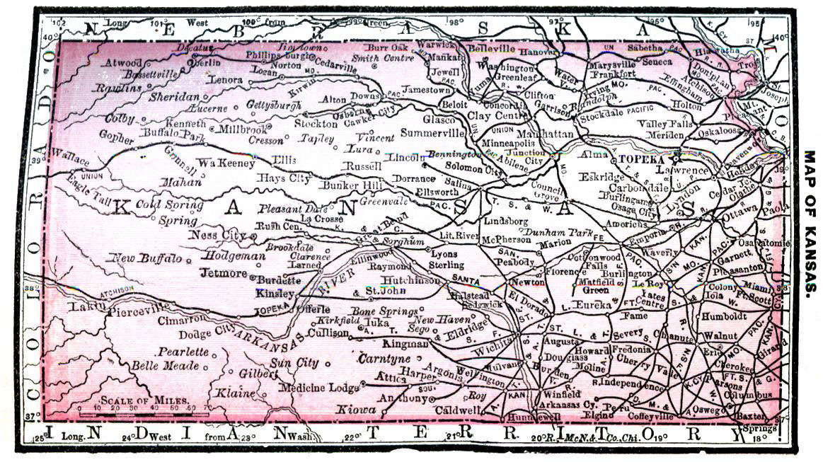
Area, 82,080 square miles. Length, 400 miles; breadth, 200 miles. Geographical centre of United States, exclusive of Alaska. Missouri river frontage, 150 miles; largest rivers, Solomon, Neosho, Saline, Arkansas, Republican and Kansas. Number counties, 100.
Temperature at Leavenworth: summer, 74° to 79°; winter, 25° to 35°: rainfall, 81 inches.
Metropolis, Leavenworth; population, 29,268. Capital, Topeka; population, 23,499. State University at Lawrence; State asylums for insane and feeble-minded at Topeka and Osawatomie; institution for education of the blind, Wyandotte; for deaf-mutes, Olathe.
First railroad built, 1865; length, 40 miles. Railroad mileage, 1875, 2,150; Jan. 1, 1886, 4,888.
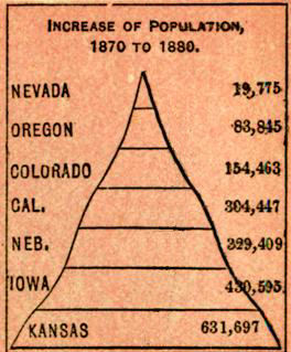
Number farms, 1860, 10,400; 1880, 138,561. Average value per acre, cultivated land, $11.82; woodland, $19.12. Peculiarly adapted for stock raising. Gain, per cent., in horses, for ten years, 138; cows, 149; mules, 1,040; other cattle, 203; sheep, 210; hogs, 132.
Salaries of State Officers. Governor $3,000 Secretary of State 2,000 Treasurer 2,500 Auditor 2,000 Attorney Gen. 1,500 Supt. Pub. Inst. 2,000 Sec. Bd. of Agr. 2,000 Insurance Com. 2,500 3 R. R. Coms. 3,000 State Librarian 1,500 Chief Justice 3,000 2 Asso. Justices 3,000 Senators, Representatives $3 pr. day mileage 15 cents. District Judge 3,500 Pension Agent 4,000 Col. Int. Rev. 2,750 9 Deputy Collectors $1,650 to 400 Indian Agent 1,000 Presidential P. O. Atchison $2,700 Emporia 2,500 Fort Scott 2,400 Lawrence 2,600 Leavenworth 2,800 Newton 2,000 Ottawa 2,100 Parsons 2,100 Salina 2,000 Topeka 3,100 Wellington 2,000 Wichita 2,400 Winfield 2,100 Wyandotte 2,400 78 Offices 1,900 to 1,000
Latest reported crop: castor beans, 765,143 bu.; cotton, 33,589 lbs.; flax, 622,256 bu.; hemp, 557,879 bu.; corn, 1884, 168,500,000 bu.; wheat, 34,990,000 bu.; oats, 27,419,000 bu.
Number hands employed in manufactories, 1860, 1,735; in 1870, 6,844; in 1880, 12,064. Net value of manufactured products increased 67 per cent. in first period, 95 per cent. in second.
Ranks fifth in cattle, corn and rye; seventh in hay, and ninth in hogs, horses, wheat and coal. Coal area, 17,500 square miles.
Population, 996,096: male, 536,667; female, 459,429; native, 886,010; foreign, 110,086; white, 952,155; colored, 43,107; Chinese, 19; Indians, 815. State, congressional and presidential elections, Tuesday after first Monday in Nov.; Senators, 40; Representatives, 125; sessions biennial, meeting second Tuesday in January in odd-numbered years; limit of session, 50 days; term of Senators, 4 years; of Representatives, 2 years.
Number electoral votes, 9; number voters, 265,714. Idiots, insane, convicts and rebels excluded from voting.
Number colleges, 8; number schoolhouses, over 5,000; school attendance, 69 per cent. of school population; school age, 5-21.
Legal interest, 7; by contract, 12; usury forfeits excess of interest.
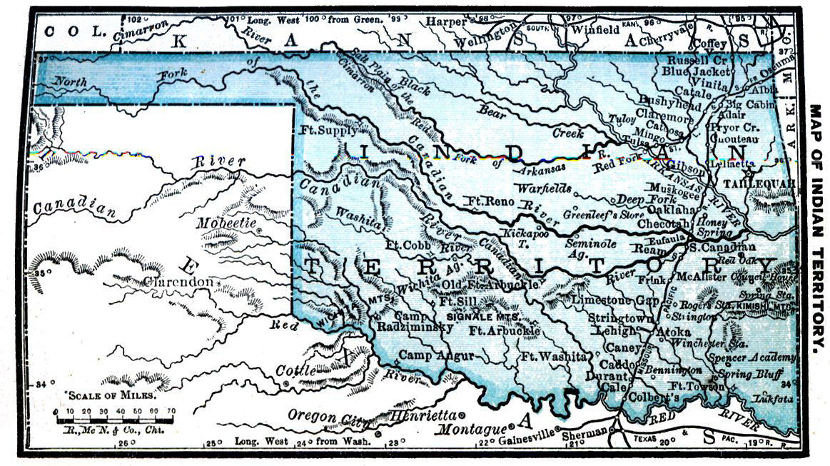
INDIAN TERRITORY.
Portion of great Louisiana purchase set apart for home of peaceable Indian tribes; organized 1834.
Cut down to form States and Territories, leaving but 64,690 square miles, or 41,401,600 acres; nearly 26,000,000 acres being Indian reservations.
Length east and west on the north, 470 miles; breadth west of 100th meridian, 35 miles, and east of that line, about 210 miles. Reservations of Cherokees, 5,000,000 acres in north and northeast; Seminoles, 200,000 in east central; Creeks, 3,215,495 in east; Chickasaws, 4,377,600 in south; the Oklahoma country near centre. Principal rivers, Arkansas and Red. Number nations, agencies and reservations, 22.
Temperature at Fort Gibson: winter, 35° to 48°: summer, 77° to 82°. Rainfall in extreme northwest, 20 inches, and at Fort Gibson, 36 inches.
Most important town, and capital of Cherokees, Tahlequah. Railroad mileage, 372. Capital of Chickasaws, Tishomingo; of Choctaws, Tushkahoma; of Creeks, Muscogee; of Osages, Pawhuska; of Seminoles, Seminole Agency; of Pawnees, Pawnee Agency; of Kiowas and Comanches, Kiowa and Comanche Agency.
Indian Agencies. ARAPAHOE. Agent $900 CHEYENNE. Agent $2,200 Physician 1,200 KAW. Superintend't $1,600 Physician 1,200 KIOWA AND COMANCHE. Agent $1,000 Physician 1,000 OAKLAND. Superintend't. $1,000 8 Teachers 600 OSAGE. Agent $1,600 Physician 1,200 OTOE. Agent $1,500 Physician 1,000 PAWNEE. Clerk $1,200 Physician 1,000 PONCA. Superinden't $1,200 Clerk 720 QUAPAW. Agent $1,500 Physician 1,200 SAC AND FOX. Agent $1,200 2 Physicians 1,000
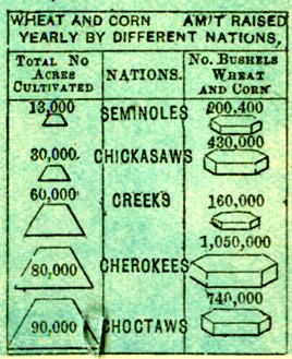
Corn, wheat, tobacco, cotton and potatoes yield luxuriantly. Number horses, January, 1883, 125 per cent. of previous year; mules, 110 per cent.; hogs, 80 per cent.; milch cows, 85 per cent.; number sheep, 55,000, at average value of $2; oxen and other cattle, January, 1884, 520,000, valued at $8,840,000.
Stringent laws to protect from encroachments by whites. They can hold land only by marrying into one of the tribes. Recent official reports give Indian population about 80,000: Cherokees, 20,000; Choctaws, 16,500; Creeks, 14,500; Chickasaws, 7,000; Seminoles, 2,500; Osages, 2,390; Cheyennes, 3,298; Arapahoes, 2,676; Kiowas, 1,120; Pawnees, 1,438; Comanches, 1,475.
No Territorial government has as yet been organized, owing to differences in the views of Congress and the tribes. For each agency, a deputy is appointed by the President to represent the United States, but each tribe manages its own internal affairs. Most of the tribes governed by chiefs.
Of first five tribes, 33,650 can read, and have 16,200 houses, 195 schools, and 6,250 pupils. Expended from tribal funds for educational purposes, $156,856; from government appropriations for freedmen, $3,500.
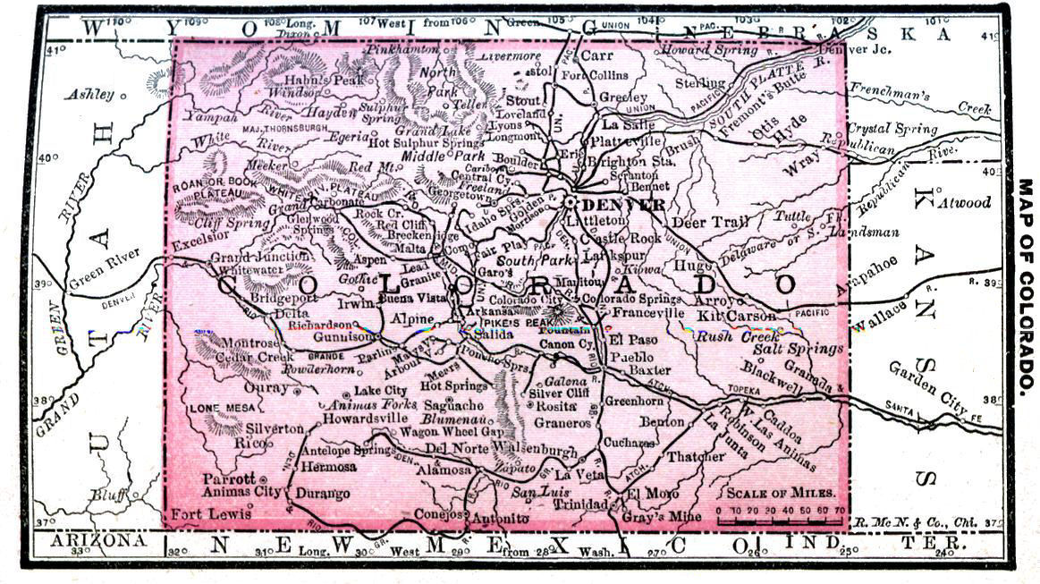
COLORADO. Kol-o-rah´do. "Centennial State."
Part of Louisiana purchase of 1803. First explored by Vasquez Coronado under the Spanish, 1540. First expedition sent out by United States Government, under Major Pike, 1806; a second under command of Col. S.H. Long, 1820, and in 1842-44, Gen. John C. Fremont made his celebrated trip across the Rocky Mountains. First settlements made by miners, 1858-9; formed from parts of Kansas, Nebraska, Utah and New Mexico; organized as a Territory, February, 1851; admitted August 1, 1876.
Area, 103,925 square miles; length, 380 miles; breadth, 280 miles; principal rivers, North and South Platte, Arkansas, Snake, White and Green. Number counties, 40. Temperature at Denver: winter, 25° to 37°; summer, 72° to 74°. Rainfall of the State from 15 to 20 inches, falling mostly between May and July.
Five United States land districts, with offices at Denver, Pueblo, Fairplay, Lake City and Central City. Denver, capital and metropolis, and contains assay office; pop., 54,308; Leadville, 10,925; Silver Cliffs, 900; Colorado Springs, 4,563. State University at Boulder; Agricultural College at Fort Collins; School of Mines at Golden City.
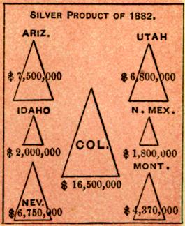
Richest State in the Union in mineral productions, ranking first in silver, and fourth in gold.
Salaries of State Officers. Governor $5,000 Lieut. Gov. 1,000 Sec'y of State 3,000 Treasurer 3,000 Auditor 2,500 Attorney Gen. 2,000 Chief Justice 5,000 2 Asso. Justices 5,000 Senators, Representatives $4 pr. day mileage 15 cents. District Judge 3,500 Col. Int. Rev. 2,875 Surveyor Gen. 2,500 Ute Indian Agt. 1,400 DENVER MINT. Assay'r in Chg. $2,500 Presidential P. O. Boulder $1,900 Canon City 1,600 Central City 1,700 Colorado Spgs. 2,400 Denver 3,400 Durango 1,700 Fort Collins 1,700 Georgetown 1,700 Golden 1,600 Greeley 1,800 Gunnison 1,900 Leadville 2,800 Pueblo 2,400 Salida 1,600 Silverton 1,800 South Pueblo 2,200 Trinidad 1,800 17 Offices 1,600 to 1,000
Corn crop, 1884, 710,000 bushels; wheat, 2,348,000 bushels; oats, 1,516,000 bushels; 1,209,000 bushels produced 1883, the yield being 29.3 bushels per acre; hay, 114,505 tons, valued at $1,545,818. Cattle raising a safe and profitable business; sheep husbandry still more profitable; latest reported estimate gives 815,674 cattle, 1,248,360 sheep and 12,342 swine.
Population, 243,910: male, 144,781; female, 99,129: native, 192,568; foreign, 51,342: white, 239,585; colored, 3,262; Chinese, 861; Indians, 202.
State, congressional and presidential elections, Tuesday after first Monday in November; number Senators, 26: Representatives, 49; sessions biennial, in odd-numbered years, meeting first Monday in January; limit of session, 40 days; term of Senators, 4 years; of Representatives, 2 years.
Number electoral votes, 3; number voters, 93,608; native white, 65,215; foreign white, 26,873; colored, 1,520. Persons in prison excluded from voting.
Not a mile of railroad in use in 1870; mileage, January 1, 1886, 2,857. Number colleges, 3; school population, 40,208; school age, 6-21.
Legal Interest rate, 10; by contract, any rate.
NEW MEXICO.
Named in honor of one of the gods of the Aztecs, the ancient inhabitants of Mexico.
Colonized by Spaniards, 1582; Santa Fé being oldest town in United States, next to St. Augustine; organized 1850.
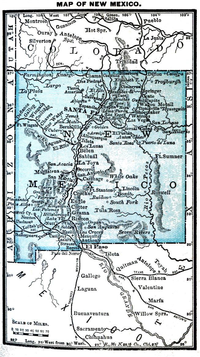
Area, 122,580 square miles; length eastern boundary, 345 miles; western, 390 miles; average breadth north of 32°, 335 miles; altitude, 3,000 to 4,000 feet. Number counties, 13.
Temperature at Santa Fé, winter, 27° to 37°; summer, 66° to 70°. Rainfall, Fort Marcy, 17 inches.
Santa Fé is capital and principal city; pop., 6,635. Las Vegas, Silver City and Albuquerque are growing in importance.
But 8 miles railroad in operation in 1878, having increased to 1,140, January 1, 1884.
Crops abundant wherever water can be obtained, and corn will ripen almost anywhere; 6,060 square miles irrigable land; number farms, 5,053; corn crop, 1884, 950,000 bu.; wheat, 930,000 bu.; oats, 252,000 bu. Total acreage of the Territory, 78,451,200; in farms, 631,131; in forests, 219,224; unoccupied, 77,820,069; proportion woodland area in the farm lands, 35 per cent. Average value corn, 1884, 68 cents; wheat, 90 cents; oats, 40 cents.
Salaries Territor'l Officers. Governor $2,600 Secretary 1,800 Treasurer 1,000 Auditor 1,000 Com'r Immig'n 900 Librarian 600 Chief Justice 3,000 2 Asso. Justices 3,000 Senators, Representatives $4 a day & 20c. mileage. Col. Int. Rev. 2,500 2 Dep Colls. Int. Rev. 1,200 to 1,700 Surveyor Gen. 2,500 Translator and Chief Clerk 2,000 2 Spec'l Draftsmen $1,500 Clerk 1,500 Messenger 500 Indian Agents Jicarilla $1,200 Mescalero 1,500 Navajo 1,500 Pueblo 2,000 Presidential P. O. Albuquerque $2,300 Deming 1,500 Las Vegas 2,100 Raton 1,200 Santa Fe 2,000 Silver City 1,800 Socorro 1,600
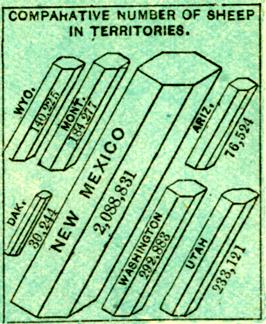
Grazing interest extensive and valuable. Recent reports give mules, 10,183; sheep, 4,435,200, valued at $7,539,840; hogs, 23,353, valued at $187,758.
Mineral wealth is rapidly developing. Gold is found in Grant, Lincoln, Colfax and Bernalillo counties; rich copper mines on the San Pedro Grant, in Bernalillo county, and in the Pinos Altos region. Zinc, quicksilver, lead, manganese, and large deposits of coal have been found. Gold production, 1882, was $150,000; silver, $1,800,000.
Population, 119,565: male, 64,496; female, 55,069; native, 111,514; foreign, 8,051; white, 108,721; colored, 1,015; Chinese, 57; Indians, 9772
Territorial and congressional elections, Tuesday after first Monday in November; number Senators, 12; Representatives, 24; sessions of legislature biennial, in even-numbered years, meeting first Monday in January; limit of session, 60 days; terms of Senators and Representatives, 2 years each. Voting population, 34,076; native white, 26,423; foreign white, 4,558; colored, 3,095.
School population, 20,255; school age, 7-18.
Legal interest rate, 6; by contract, 12.
ARIZONA.Ar-ĭ-zō´na.
First visited by Spanish explorers as early as 1526; set off from New Mexico and became a Territory, 1863.
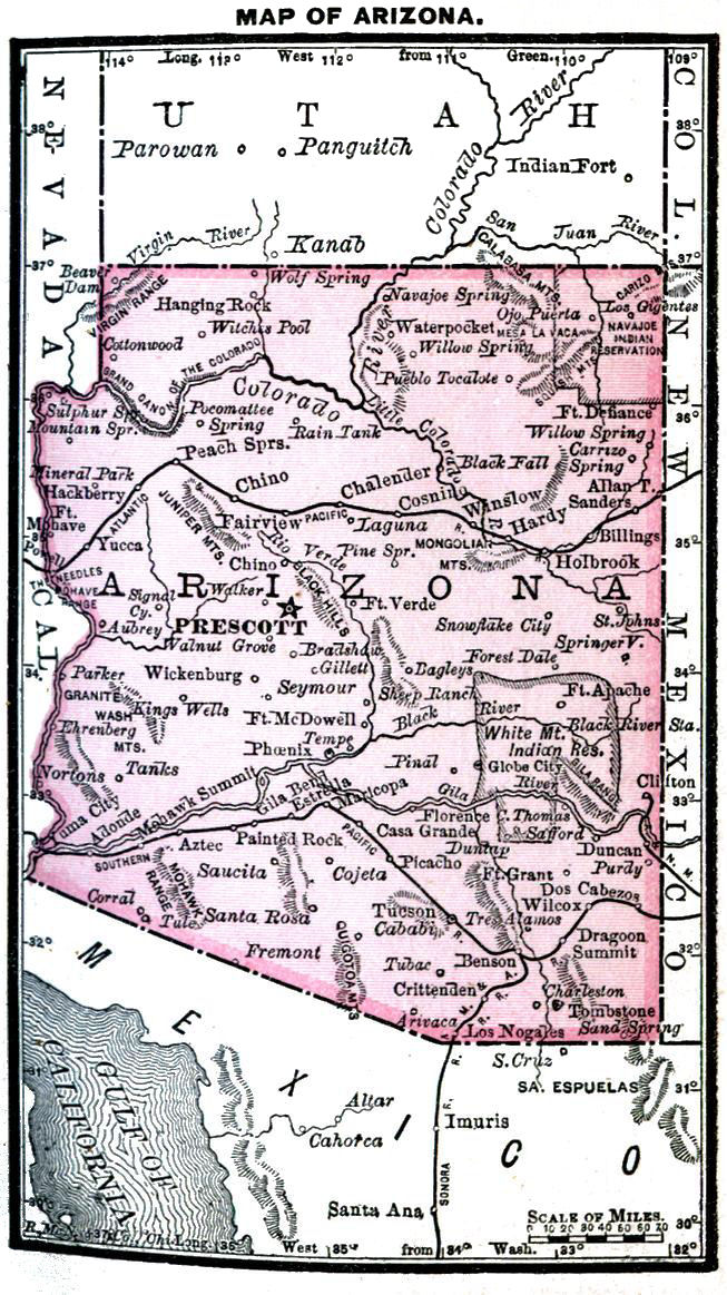
Area, 113,020 square miles; greatest length, 375 miles; greatest breadth, 340 miles. Country drained by Colorado and Gila, with their tributaries; number counties, 11.
Temperature at Prescott: winter, 34° to 42°; summer, 71° to 73°. Rainfall at Fort Defiance, 14 inches.
Tucson, the largest town: population, 7,007. Prescott, the capital. Railroad mileage, 865; Southern Pacific crosses from east to west near southern boundary, and Atlantic & Pacific north of the central portion, making ready communication with East and West.
Crop reports, 1883: wheat, 222,200 bu.; barley, 330,775 bu.; potatoes, 52,936 bu.: hay, 10,710 tons; corn acreage, 1884, 2,850, producing 60,300 bu. Soil fertile in river bottoms and among valleys of Middle and Eastern Arizona, corn planting following wheat or barley harvest, giving two crops yearly; oranges and other fruits and potatoes produce well wherever there is water; principal portion of irrigable land lies in valley of Gila and its northern branches; rich and abundant grasses, together with mild climate, make much of the Territory well adapted to stock raising; valuable timber on the mountains and along the streams.
Salaries Territorial Officers. Governor $2,600 Secretary 1,800 Treasurer 1,000 Auditor 1,000 Supt. Pub. Inst. 2,000 Librarian 600 Chief Justice 3,000 2 Asso. Justices 3,000 Senators, Representatives $4 a day and 20c. mileage. 3 Dist. Judges. 3,000 Col. Int. Rev. 2,250 2 Deputy Collectors 1,600 to 1,700 Clerk 1,100 Surveyor Gen. $2,500 Chief Clerk 2,400 Land Clerk 1,600 Land Copyist 1,200 Spanish Trans'r 2,500 Indian Agents. Colorado River $1,500 Pima & Maricopa 1,800 San Carlos 2,000 Presidential P. O. Clifton $1,000 Globe 1,100 Phœnix 1,500 Prescott 1,800 Tombstone 1,900 Tucson 2,300
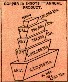
Abundant mineral wealth, which can now be developed with profit, owing to completion of railways; nearly all mountain ranges contain gold, silver, copper and lead; gold production, 1882, $1,065,000; silver, $7,500,000.
Ranks second in silver, and ninth in gold.
Superior quality of lime found near Prescott and Tucson; beds of gypsum in San Pedro valley; remarkable deposits of pure, transparent salt near Callville.
Population, 40,440: male, 28,202; female, 12,238; native, 24,391; foreign, 16,049; white, 35,160; colored, 155; Chinese, 1,630; Indians, 3493
Territorial and congressional elections, Tuesday after first Monday in November; number Senators, 12; Representatives, 24; sessions of legislature biennial, in even-numbered years, meeting first Monday in January; limit of session, 60 days; terms of Senators and Representatives, 2 years each. Voting population, 20,398; native white, 9,790; foreign white, 8,256; colored, 2,352.
School population, 10,283; school age, 6-21.
Legal interest rate, 10; by contract, any rate; no penalty for usury.
UTAH.Yoo´tah.
Settled by Mormons under the leadership of Brigham Young, Salt Lake, 1847. Territorial government formed 1850.
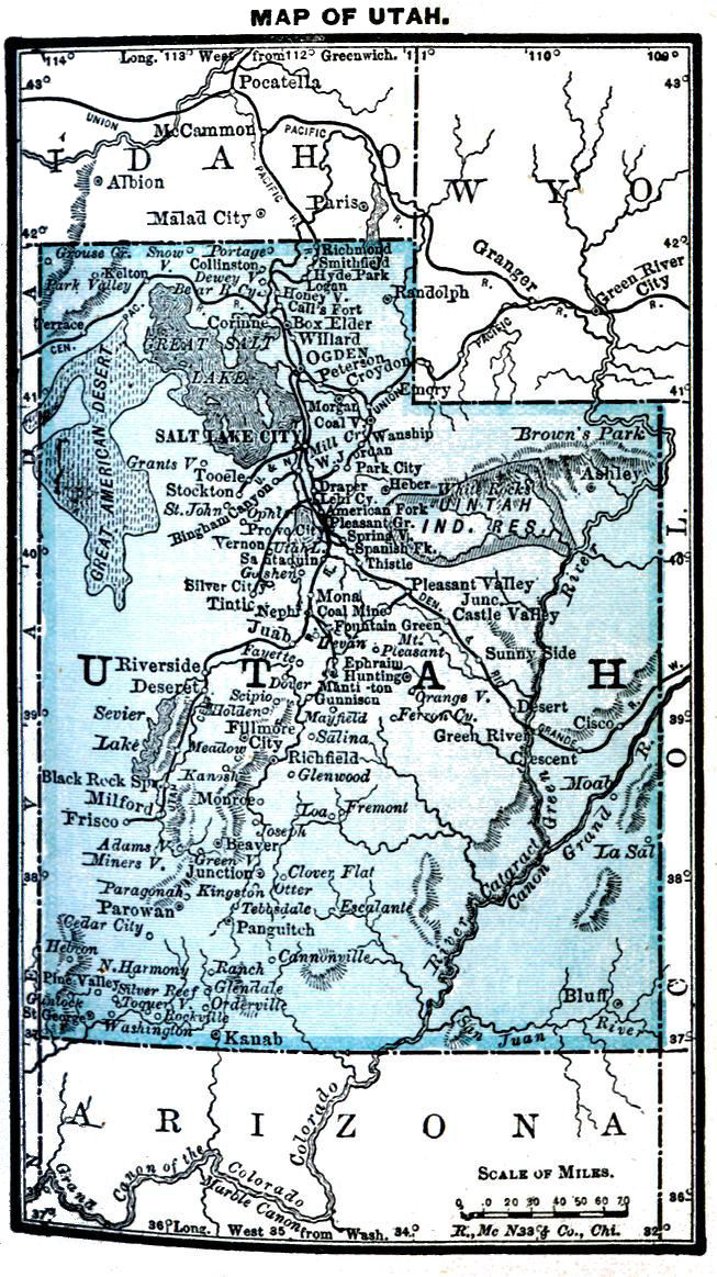
Area, 84,900 square miles, very nearly same as Idaho; average length, 350 miles; breadth, 260 miles. Largest rivers, Grand and Green, together with the Colorado, which they unite to form. Number counties, 24.
Temperature at Salt Lake City: winter, 29° to 40°; summer, 69° to 77°: rainfall, 24 inches.
Salt Lake City, capital and metropolis; pop., 20,768. Ogden, at junction of Union and Central Pacific, pop., 6,069. Railroad mileage, 1,134; Union and Central Pacific through the north.
Number farms, 9,452; land under cultivation, over 400,000 acres; value farm products, $10,000,000. Valleys of the Cache, Salt Lake, Jordan, Sevier and Rio Virgin, are irrigable, and produce fine crops of cereals and vegetables. Wheat crop of 1884, 1,675,000 bushels.
Annual income from stock raising, about $2,000,000, though grazing interest perhaps not so important as in neighboring States and Territories.
Salaries of Territorial Officers. Governor $2,600 Secretary 1,800 Treasurer 600 Auditor 1,500 Supt. Pub. Ins. 1,500 Librarian 250 Chief Justice 3,000 2 Asso. Justices 3,000 Senators, Representatives $4 a day mileage 20 cents. Dist. Attorney 250 & fees. 11. U.S. Commissioners Fees. Col. Int. Rev. 2,500 2 Dep'y Collectors 1,600 to 1,800 Surveyor Gen. $2,500 Chief Clerk 1,800 Chief Draftsman 1,500 Indian Agents Ouray $1,500 Clerk 1,000 Uintah Valley 1,500 Clerk 1,000 Presidential P. O. Logan $1,200 Ogden City 2,400 Park City 1,500 Provo City 1,100 Salt Lake City 2,900
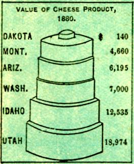
Gold, copper and silver found in Wahsatch Mountains, the metal found being mostly silver. Gold production, 1882, $190,000; silver, $6,800,000.
Production coal, 1882, 250,000 tons; principal source of supply in valley of Weber river.
Ranks third in silver, and seventh in salt, an inexhaustible supply of the latter being furnished by the lake.
Population, 143,963: male, 74,509; female, 69,454; native, 99,969; foreign, 43,994; white, 142,423; colored, 232; Chinese, 501; Indians, 807
Territorial elections annual, first Monday in August; congressional elections, Tuesday after first Monday in November; number Senators, 12; Representatives, 24; sessions of legislature, biennial, in odd-numbered years, meeting second Monday in January; limit of session, 60 days; terms of Senators and Representatives, 2 years each.
Voting population, 32,773: native white, 13,795; foreign white, 18,283; colored, 695.
School population, 43,303; school age, 6-18; number colleges, 1.
Legal Interest rate, 10; by contract, any rate.
WYOMING.Wī-ō´ming.
First settlements, trading posts of Forts Laramie and Bridger; organized 1869.
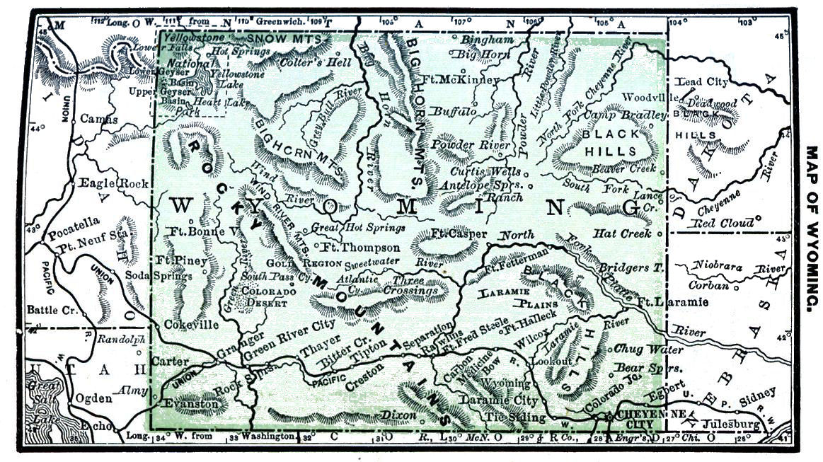
Area, 97,890 square miles; very nearly a rectangle, and about the same area as Oregon; length, 350 miles; breadth, 275 miles. Largest rivers, Green, Snake, Big Horn, Powder, Big Cheyenne and North Platte. Number counties, 9. Temperature at Cheyenne: winter, 23° to 33°; summer, 63° to 69°. Rainfall at Fort Laramie, 15 inches.
Cheyenne is the capital and principal distributing point. Railroad mileage, 625; Union Pacific runs through extreme south from east to west, and connects Cheyenne with Denver.
Wheat, rye, oats and barley flourish, but frosts too frequent for corn. Big Horn country, in northwest, has area 15,000 square miles; fine agricultural country; water plentiful; game and fur-bearing animals numerous, rendering it one of most desirable hunting grounds of America. Grazing interest important, and increasing rapidly, more than half the area being rich grazing land. Mountains covered with forests of coniferæ, which will prove very useful for lumber.
Salaries of Territorial Officers. Governor $2,600 Secretary 1,800 Treas., $800 and com. Auditor 1,000 Supt. Pub. Inst. 400 Librarian 400 Chief Justice 3,000 2 Asso. Justices 3,000 Senators, Representatives $4 a day and 20c. mileage. Col. Int. Rev. 2,000 2 Dept. Colls. Inter. Rev. 1,400 to 1,500 Surveyor Gen. 2,500 Chief Clerk 2,000 Chief Draftsman 1,800 8 Asst. Draftsmen $1,400 6 Asst. Draftsmen 1,200 2 Transcribing Clerks 1,400 6 Transcribing Clerks 1,200 Messenger 600 Supt. Yellowstone Nat. Pk. 2,000 10 Assistants 900 Presidential P. O. Cheyenne City $2,400 Evanston 1,500 Laramie City 1,800 Rawlins 1,400
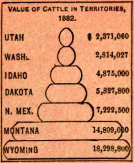
Mineral resources extensive; iron ore abundant; copper, lead, plumbago and petroleum found; gold, in the Sweetwater country and near Laramie City; valuable deposits of soda in valley of the Sweetwater. Coal abundant and of good quality at Evanston, Carbon, Rock Springs and other points; these deposits extensively worked, and furnish nearly all the coal used by the railroads and by settlements hundreds of miles east and west.
But little attention has as yet been given to mechanical and manufacturing industries. Capital, as last reported, $364,673, of which $212,603 is invested in manufacture of iron and steel. Value of products of the latter is $491,345; total value of products, $898,494. Number hands employed, 391.
Population, 20,789: male, 14,152; female, 6,637; native, 14,939; foreign, 5,850; white, 19,437; colored, 298; Chinese, 914; Indians, 140.
Territorial and congressional elections, Tuesday after first Monday in November; number Senators, 12; Representatives, 24; sessions of legislature biennial, in even-numbered years, meeting second Tuesday in January; limit of session, 60 days; terms of Senators and Representatives, 2 years each. Voting population, 10,180; native white, 6,042; foreign white, 3,199; colored, 939.
Good school system started; school pop., 4,112; school age, 7-21.
Legal interest rate, 12; by contract, any rate.
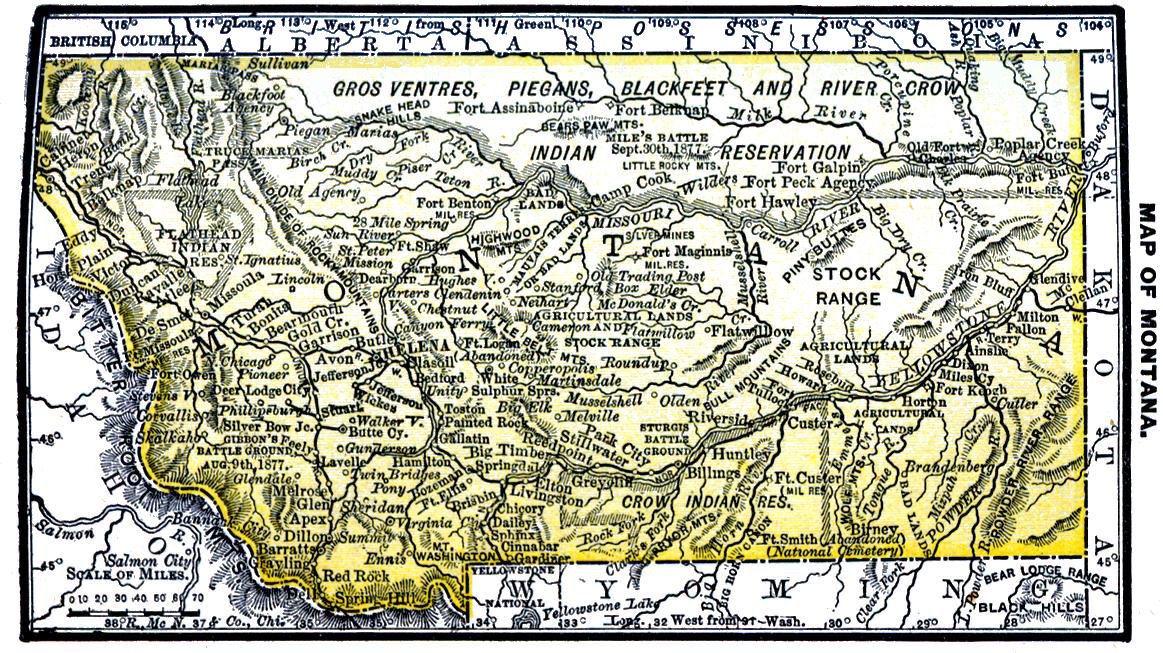
MONTANA.Mŏn-ta´nah.
Formerly a part of Idaho; became a Territory, 1864; received about 2,000 square miles from Dakota, 1873.
Area, 146,080 square miles; length, east and west, 460 to 540 miles; average breadth, 275 miles. Drained by the Missouri and its tributaries and the tributaries of the Colorado. Number of counties, 14
Temperature at Virginia City, winter, 17° to 30°; summer, 55° to 65°: rainfall seldom exceeds 12 inches per annum.
Three U.S. districts; court held twice a year at Helena, twice at Virginia City, and three times at Deer Lodge. Helena, the capital and most important town. Railroad mileage, 1,032; Northern Pacific extends through the Territory from east to west.
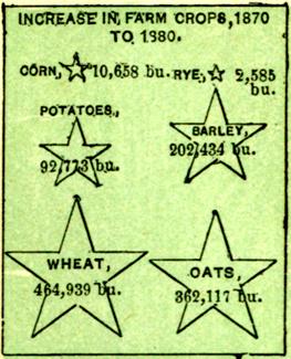
Immense areas cultivable land; cereal productions, 1882, were 1,857,540 bu., of which 1,100,000 were oats; potatoes yielded 300,000 bu., and hay 93,000 tons. Wheat crop in 1884, 1,372,000 bu.; oats, 1,740,000 bu. Some varieties of corn grown in portions of Territory, but generally too cold.
Grazing interest of value; estimated area valuable grazing land, 100,000 square miles; great extent of plains and mountain valleys yet untouched by herdsmen. Latest returns give 686,839 cattle, 465,750 sheep, and 17,544 swine.
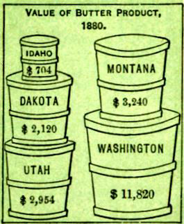
Salaries Territorial Officers. Governor $2,600 Secretary 1,800 Treasurer 1,500 Auditor 1,500 Supt. Public Instruction 1,200 Chief Justice 3,000 2 Asso. Justices 3,000 Senators, Representatives $4 pr. day and 20 c. mileage. Surveyor Gen. 2,500 Chief Clerk 1,800 Chf. Draftsman 1,600 Col. Int. Rev 2,500 5 Deputy Colls. Internal Rev. 1,600 Assayer 2,500 Melter 2,250 Indian Agents. Blackfeet $1,800 Crow 2,000 Flathead 1,500 Presidential P. O. Billings $1,500 Bozeman 1,800 Butte City 2,500 Deer Lodge City 1,500 Dillon 1,400 Fort Benton 1,600 Glendive 1,100 Helena 2,500 Livingston 1,600 Miles City 1,600 Missoula 1,700 Virginia City 1,000
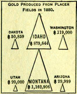
One of richest mining countries in the world; mineral wealth almost inexhaustible. Product for 1879 was $3,629,000, of which ⅔ was gold and ⅓ silver; product, 1880, was $3,822,379, of which ⅔ was silver and ⅓ gold; production, 1882, $6,920,000, of which ⅔ was silver and ⅓ gold.
Manufacturing interests mainly smelting works, and flour and lumber mills. Ranks fifth in silver and in gold.
Population, 39,139; male, 28,177; female, 10,982; native, 27,638; foreign, 11,521; white, 35,385; colored, 346; Chinese, 1,765; Indians, 1663
Territorial and congressional elections, Tuesday after first Monday in November; number Senators, 12; Representatives, 24; sessions of legislature, biennial, in odd-numbered years, meeting second Monday in January; limit of session, 60 days; terms of Senators and Representatives, 2 years each. Voting population, 21,544; native white, 12,162; foreign white, 7,474; colored, 1,908.
School population, 10,482; school age, 4-21; graded schools in Deer Lodge City, Virginia City and Helena.
Legal interest rate, 10; by contract, any rate.
IDAHO.Ī´dah-ho
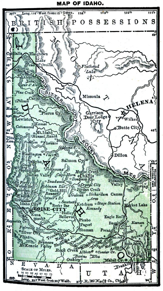
White population previous to 1850, mainly trappers, prospectors and missionaries; permanent settlement began with discovery of gold, 1860; organized as Territory, 1863.
Area, 84,800 square miles; length in west, 485 miles, and on Wyoming boundary, 140 miles; width, 45 miles in north, and nearly 300 miles in south. Drainage mainly by Salmon and Snake rivers and their tributaries. Number counties, 15.
Temperature at Boisé City: winter, 30° to 40°; summer, 68° to 75°.
Boisé City, the capital, and contains national bank and penitentiary. Florence and Silver City are flourishing mining towns. Railroad mileage, 777; Northern Pacific crosses northern part.
Extreme north well timbered and much fertile land; extreme southeast populated almost entirely by Mormons, chiefly farmers; 4,480,000 acres suitable for agriculture, and 5,000,000 for grazing, most of the ranges being as yet unoccupied. Latest reports give, cattle, 220,612; sheep, 187,500; swine, 24,780.
Cash value per acre of corn in 1883, $18; wheat, $13.77; rye, $11.79; oats, $21.31; barley, $21.30; potatoes, $73.44; hay, $10.40.
Salaries Territorial Officers. Governor $2,600 Secretary 1,800 Treasurer 1,000 Auditor 1,800 Librarian 250 Chief Justice 3,000 2 Asso. Justices 3,000 Senators, Representatives $4 a day and 20c. mileage. 2 Dist. Attorneys 250 & fees Col. Int. Rev. 2,250 3 Dep. Collectors 1,400 to 1,600 Assayer 2,000 Asst. Assayer 1,440 Clerk $1,000 Asst. Melter 1,200 Surveyor Gen'l 2,500 Chief Clerk 1,800 Draftsman 1,500 Messenger 600 Indian Agents. Fort Hall $1,500 Lemhi 1,100 Nez Perces 1,600 Presidential P. O. Bellevue $1,200 Boise City 1,800 Hailey 1,200 Ketchum 1,000 Lewiston 1,200
Most of the gold is found in Idaho, Boisé and Alturas counties; silver, in Owyhee county; some of the mines being very rich. Gold production, 1883, $1,500,000; silver, $2,000,000. Wood River District on southern slope of Salmon River Mountains, at headwaters of Wood or Malade river, gives promise of valuable mining operations. Coal in vicinity of Boisé City. Ranks sixth in gold and silver.
Manufactures, chiefly production of flour and lumber, and smelting of ores.
Population, 32,610: males, 21,818; female, 10,792; native, 22,636; foreign, 9,974; white, 29,013; colored, 53; Chinese, 3,379; Indians, 165
Territorial and congressional elections, Tuesday after first Monday in November; number Senators, 12; Representatives, 24; sessions of legislature biennial, in even-numbered years, meeting second Monday in December; limit of session, 60 days; terms of Senators and Representatives, 2 years each.
Voting population, 14,795; native white, 7,331; foreign white, 4,385; colored, 3,126.
School population, 9,650; school age, 521.
Legal interest rate, 10; by contract, 18; usury forfeits three times excess of interest.
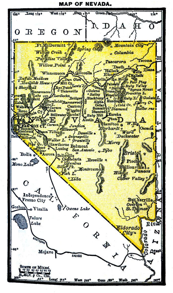
NEVADA. Ne-vah´dah. "Sage Hen State."
Name of Spanish derivation, signifying "Snow-covered."
First white settlements in Washoe and Carson valleys, 1848; organized as a Territory from Utah, 1861; admitted, 1864.
Area, 110,700 square miles; extreme length, 485 miles; length western boundary, 210 miles; extreme breadth, 310 miles. Humboldt the longest river; its valley, extending east and west, determined course of Central Pacific. Number counties, 15.
Temperature at Winnemucca: winter, 30° to 38°; summer, 66° to 73°.
Virginia City, metropolis and chief commercial centre; population, 10,917. Carson City, capital, and contains a branch mint; population, 4,229. Railroad mileage, 948; Central Pacific extends through the State, east and west. Waters of rivers usually fresh, and abound in fish.
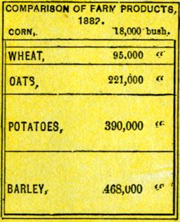
Number farms, 1,404; many valleys easily cultivated, and crop yield good. Corn, 1884, 830 acres; wheat, 5,515 acres; oats, 7,858 acres. Area grazing land, 7,508,060 acres. Reported January 1, 1884, 40,732 horses and mules; 385,350 sheep, valued at $793,821; 13,200 hogs, valued at $110,880.
Salaries of State Officers. Governor $5,000 Lieut. Gov. 3,000 Sec'y of State 3,000 Treasurer 3,000 Comptroller 3,000 Attorney Gen. 3,000 Supt. Pub. Inst. 2,400 Chief Justice 6,000 2 Asso. Justices 6,000 Senators, Representatives $8 a day and 40c. a mile. District Judge 3,500 Surveyor Gen. 3,000 Chief Clerk 2,000 Draftsman 1,500 Col. Int. Rev. 2,375 4 Deputy Collectors $1,850 to 1,950 Supt. of Mint 3,000 Melt. & Refiner 2,500 Coiner 2,500 Assayer 2,500 Cashier 2,000 Weigh. Clerk 2,000 Reg. Deposits 1,800 2 Indian Agts. 1,800 Presidential P. O. Austin $1,400 Carson City 1,800 Elko 1,200 Eureka 1,700 Gold Hill 1,000 Reno 1,800 Tuscarora 1,200 Virginia City 2,000 Winnemucca 1,200
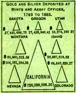
Mineral resources of enormous value; Comstock lode supposed to be richest silver mine in the world; Eureka one of the most productive. Amount of gold produced, 1882, $2,000,000; silver, $6,750,000. Rich lead and copper ores; also zinc, platinum, tin and nickel have been found. Extensive deposits of borax in Churchill and Esmeralda counties.
Ranks second in gold, and fourth in silver.
Population, 62,266; male, 42,019; female, 20,247; native, 36,613; foreign, 25,653; white, 53,556; colored, 488; Chinese, 5,416; Indians, 2803
Governor and State officers elected quadrennially, and legislature every 2 years; State, presidential and congressional elections Tuesday after first Monday in November; number Senators, 20; Representatives, 40; sessions of legislature biennial, in odd-numbered years, meeting first Monday in January; limit of session, 60 days; term of Senators, 4 years; of Representatives, 2 years. Voting population, 31,255; native white, 11,442; foreign white, 14,191; colored, 5,622. Idiots, insane and convicts excluded from voting.
Number colleges, 1; school population, 10,483; school age, 6-18.
Legal Interest rate, 10; by contract, any rate.
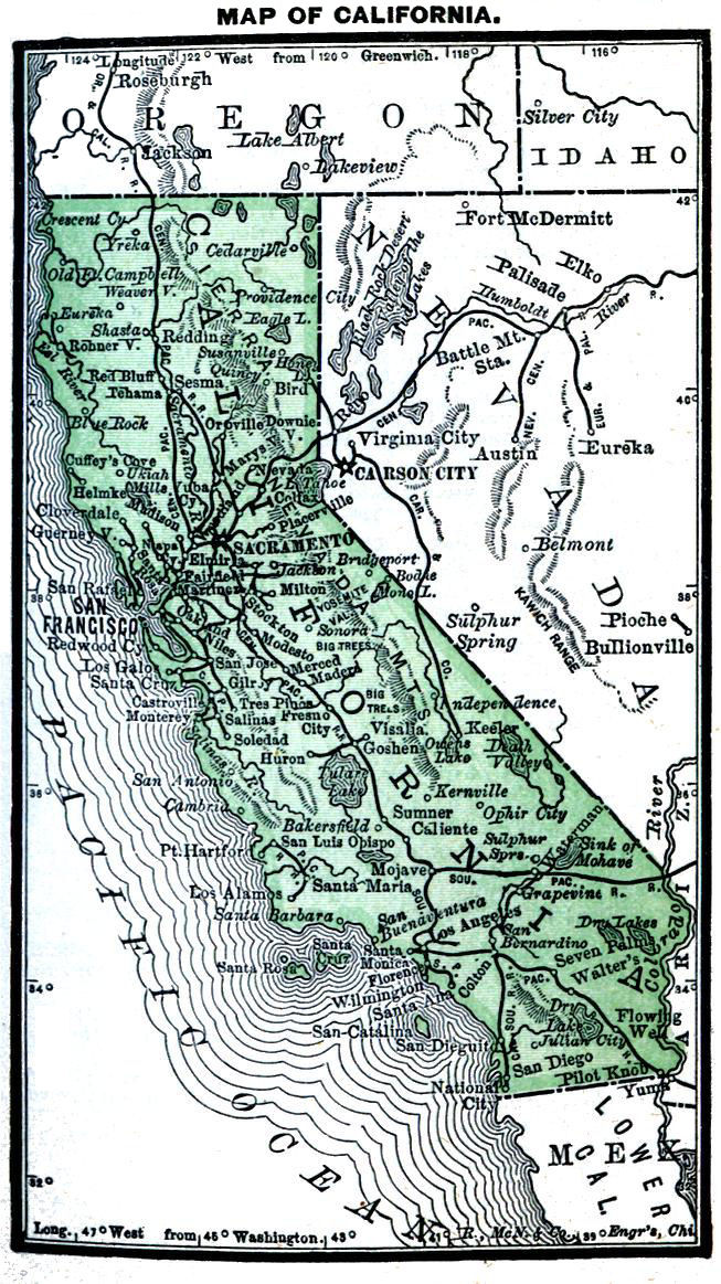
CALIFORNIA. Kal-e-for´ne-ah. "The Golden State."
Name of Spanish origin, signifying "Hot Furnace."
First settlement by Spaniards at San Diego, 1768; admitted 1850.
Area, 158,360 square miles, the second largest State; extreme length, 770 miles; extreme breadth, 330 miles; least breadth, 150 miles; coastline, over 700 miles; San Francisco Bay, best harbor on western coast. Number counties, 52.
Temperature at San Francisco: winter, 50° to 55°; summer, 58° to 69°. Rainfall, Sacramento, 20 inches.
San Francisco, metropolis and only port of entry. Regular line of steamers to Australia, Panama, Mexico, China and Japan; pop., 233,959. Sacramento, capital; pop., 21,420. Population Oakland, 34,555; San José, 12,567; Stockton, 10,282; Los Angeles, 11,183; U.S. navy yard at San Pablo Bay.
Number farms, 35,934. Average value per acre, cleared land, $27.16; woodland, $8.55.
One of the richest agricultural tracts in the Union; rich soil and favorable climate, often insuring two crops per year on same field; wheat the most valuable crop; crop of 1884, 44,320,000 bu.; corn, 8,800,000 bu.; oats, 2,149,000 bu.
Salaries of State Officers. Governor $6,000 Sec'y of State 3,000 Treasurer 3,000 Comptroller 3,000 Supt. Pub. Inst. 3,000 Attorney Gen. 3,000 Surveyor Gen. 3,000 State Librarian 3,000 District Judge 5,000 Senators, Representatives $8 a day, mileage 10c. & $25 2 Colls. Int. Revenue 3,125 to 4,500 Col. Customs San Francisco 7,000 Pension Agent 4,000 Supt. Mint 4,500 Assayer 3,000 M'lt'r & Refinr. 3,000 Presidential P. O. Chico $1,800 Fresno City 1,900 Los Angeles 3,000 Marysville 1,900 Napa City 2,000 Oakland 3,100 Petaluma 1,900 Red Bluff 1,800 Sacramento 3,000 San Bernardino 1,800 San Diego 1,800 San Francisco 5,000 San Jose 2,700 Santa Barbara 1,900 Santa Cruz 1,900 Santa Rosa 1,900 Stockton 2,500 40 P. O. 1,700 to 1000
Ranks very high as a fruit-growing state; fruits of temperate climates, about 4,000,000 trees; sub-tropical fruits and nuts, 250,000 trees; grape region north to 41°, with an average breadth of 100 miles, and contains over 21,000,000 vines.
Fine sheep-raising country. Cashmere goats have been introduced and are doing well.
Ranks first in barley, grape culture, sheep, gold and quicksilver; third in hops; fifth in wheat and salt; seventh in silk goods; eighth in soap and silver.
Population, 864,694: male, 518,176; female, 346,518; native, 571,820; foreign, 292,874; white, 767,181; colored, 6,018; Chinese, 75,132; Japanese, 86; Indians, 16,277.
Governor and State officers elected quadrennially, and legislature every two years; number Senators, 40; Representatives, 80; sessions of legislature biennial, in odd-numbered years, meeting first Monday after January 1st; limit of session, 60 days; term of Senators, 4 years; of Representatives, 2 years.
Number electoral votes, 8; number white voters, 262,583. Idiots, Indians, convicts and Chinese excluded from voting.
School population, 216,330; school age, 5-17.
Legal interest rate, 7; by contract, any rate.
OREGON.Or´e-gon.
Name derived from Spanish word signifying "Wild Thyme," so called on account of the abundance of the herb found by early explorers. Credit of discovery generally given to Captain Gray, of Boston, 1792; Fur Company's trading post at Astoria, 1811; organized as a Territory, 1848; admitted 1859.
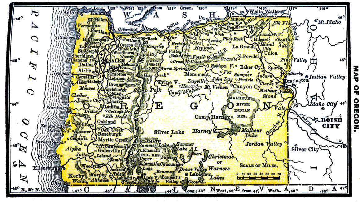
Area, 96,030 square miles; average length, 360 miles; breadth, 260 miles; coast line, 300 miles; Columbia river frontage, 300 miles. Number counties, 27. Temperature at Portland: winter, 38° to 46° summer, 62° to 68°: rainfall at Dalles, 22 inches, and at Fort Hoskins, 67 inches.
Portland, Astoria and Coos Bay are ports of entry; Oregon City, Roseburgh and La Grande are land offices. Portland, the metropolis; population, 33,400. Salem is capital.
Number farms, 16,217; about 25,000,000 acres arable land, and same of grazing land; forest, 10,000,000 acres. Average value per acre, cleared land, $21.71; woodland, $4.50.
Wheat the staple; noted for superiority of its flour and for weight, often reaching 65 pounds per bu. Wheat crop, 1884, 15,462,000 bu.; oats, 5,470,000 bu.
Salaries of State Officers. Governor $1,500 Sec. of State, Aud. & Comp. 1,500 Treasurer 800 Supt. of Pub. In. 1,500 State Librarian 500 Chief Justice 2,000 2 Asso. Justices 2,000 Senators, Representatives $3 a day and 15c. per mile. District Judge 3,500 District Attorney 200 & fees. Col. Int. Rev. 2,500 Col. Customs, Astoria 3,000 Appraiser 3,000 Surveyor Gen. 2,500 Chief Clerk $1,800 Draftsman 1,500 5 Indian Agents 1,000 to 1,800 Presidential P. O. Albany $1,500 Ashland 1,000 Astoria 1,900 Baker City 1,400 Corvallis 1,300 East Portland 1,500 Eugene City 1,400 Jacksonville 1,200 Oregon City 1,200 Pendleton 1,600 Portland 3,200 Roseburgh 1,100 Salem 2,100 The Dalles 1,700
Cattle raising ranks 2d only to agriculture; wool is of fine quality.
Extremely rich in minerals; gold found in Jackson, Josephine, Baker and Grant counties; copper, in Josephine, Douglas and Jackson counties; iron ore, throughout the State; coal, along Coast Range.
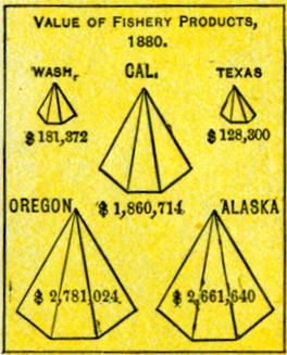
Principal exports are wheat, flour, lumber and canned salmon. Over 10,000,000 feet lumber out annually, and over 600,000 cases salmon packed.
Population, 174,768: male, 103,381; female, 71,387; native, 144,265; foreign, 30,503; white, 163,075; colored, 487; Chinese, 9,510; Indians, 1694
Governor and State officers elected quadrennially, and legislature every two years; number of Senators, 30; Representatives, 60; sessions of legislature biennial, in odd-numbered years, meeting first Monday in January; limit of session, 40 days; term of Senators, 4 years; of Representatives, 2 years.
Number of electoral votes, 3; voting population, 59,629. U.S. army, idiots, insane, convicts, and Chinese excluded from voting.
Number of colleges, 7; school population, 65,216; school age, 4-20.
Legal interest rate, 8; by contract, 10; usury forfeits principal and interest.
WASHINGTON.Wŏsh-ing-ton.
First settlement of white Americans at Tumwater, 1845, though trading posts had before been established by fur traders; organized 1853
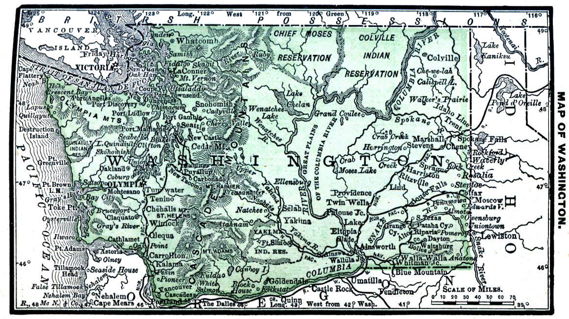
Area, 69,180 square miles, nearly same as Missouri; greatest length, 340 miles; greatest breadth, 240 miles; Pacific coast line, about 180 miles. Number counties, 33.
Temperature at Olympia: winter, 37° to 44°; summer, 59° to 62°. Rainfall, Ft. Colville, 10 inches; at Ft. Vancouver, 39 inches, and at Neah Bay, 123 inches.
Olympia is the capital, and Walla Walla and Seattle the largest towns. Harbors of Puget Sound numerous and excellent. Railroad mileage, 716; Northern Pacific from Wallula Junction to Idaho line, and from Kalama to New Tacoma, which is connected by railway with Seattle.
About 25 per cent. of area well fitted for agriculture; cereals all thrive, but generally too cold for corn; wheat crop, 1884, 4,118,000 bushels; oats, 2,623,000. Fruits of temperate zone, excepting peaches, attain perfection. Considerable attention paid to hop culture, latest reports giving 703,277 pounds; also 1,003,530 bushels potatoes.
Salaries Territorial Officers. Governor $2,600 Secretary 1,800 Treasurer 1,200 Auditor 1,200 Supt. Pub. Ins'n. 1,000 Librarian 400 Chief Justice 3,000 3 Assoc. Justices 3,000 Senators, Representatives $4 a day and 20c mileage Surveyor Gen. 2,500 Chief Clerk 1,800 Chief Drftsm'n 1,700 Col. of Customs $1,000 & fees Col. Int. Rev. 2,250 3 Dep. Colls. Int. Rev. 1,200 to 1,600 Indian Agents. Colville $1,500 Neah Bay 1,000 Nisqually 1,200 Quiniaielt 1,000 Skokomish 1,200 Tulalip 1,000 Yakama 2,000 Presidential P. O. Cheney $1,100 Colfax 1,500 Dayton 1,500 Olympia 1,600 Port Townsend 1,200 Seattle 2,500 Spokane Falls 1,700 Sprague 1,200 Tacoma 1,600 Vancouver 1,200 Walla Walla 2,300
Grazing interest valuable and rapidly increasing; grazing region east of Cascade Range, the bunch grass furnishing an inexhaustible food supply.
Coal mined at Bellingham Bay and Seattle; area coal-bearing strata, 20,000 square miles. Gold-bearing quartz and silver lodes exist in Cascade and Coast ranges; copper, cinnabar, lead and other minerals are found.
Lumber resources almost inexhaustible; amount lumber cut annually, 250,000,000 to 300,000,000 feet, 150,000,000 being exported.
Population, 75,116: male, 45,973; female, 29,143; native, 59,313; foreign, 15,803; white, 67,199; colored, 325; Chinese, 3,186; Indians, 4,405.
Territorial and congressional elections, Tuesday after first Monday day in November; number Senators, 12; Representatives, 24; sessions of legislature biennial, in odd-numbered years, meeting first Monday in October; terms of Senators and Representatives, 2 years each; limit of session, 60 days. Voting population, 27,670; native white, 15,858; foreign white, 8,393; colored, 3,419.
Number colleges, 2; school population, 23,890; school age, 4-21.
Legal interest rate, 10; by contract, any rate.
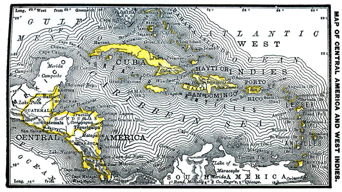
CENTRAL AMERICA AND WEST INDIES.
Central America is an irregular mass of land in southern part of North America, and lies about midway between the two great continental masses of the New World. It includes the republics of Guatemala, Honduras, San Salvador, Nicaragua and Costa Rica, together with British Honduras.
The West Indies, an extensive system of islands lying southeast of North America, contain the large islands of Cuba, Hayti, Jamaica and Porto Rico, and are arranged mostly in three groups; viz., Greater Antilles, Lesser Antilles and the Bahamas.
Area, Sq. Miles Pop. Capital. Pop.
British Honduras 7,562 27,452 Belize 5,767
Costa Rica 26,040 190,000 San Jose 20,000
Guatemala 41,830 1,278,311 New Guatemala 55,728
Honduras 39,600 458,000 Tegucigalpa 12,000
Nicaragua 49,500 400,000 Managua 12,000
San Salvador 7,225 554,785 San Salvador 18,500
Cuba 43,220 1,521,684 Havana 25,000
Hayti Hayti San Domingo 10,204 572,000 Port-au-Prince 35,000

18,045 400,000 San Domingo 10,000
Jamaica 4,362 585,536 Kingston 38,566
Porto Rico 3,550 754,313 San Juan 27,000
Statement of Exports and Imports at Belize for the year ending Dec. 31, 1882.
EXPORTS. IMPORTS.
Bananas $10,980 Boots and Shoes $13,918
Cocoanuts 25,132 Butter 14,783
Sarsaparilla 14,278 Cotton Goods 190,436
Logwood 306,072 Beef and Pork 59,405
Mahogany 215,807 Hardware and Cutlery 38,234
Rubber 18,064 Flour 71,200
Raw Sugar 218,913 Fancy Goods 24,844
Exports of Cuba, 1882-83.
Baracoa—1883.
Cocoanuts, hundreds 9,083,305
Bananas, bunches, hundred 628,916
Value $671,925
Cocoanut Oil 98,930
Santa Cruz—1882. Sagua and Cardenas—1882.
Mah'any and cedar logs $166,577 Sugar $17,484,884
Palm Leaf 8,453 Molasses 3,941,522
Mahogany Crutches 1,490 Melada 262,233
Exports of Porto Rico, 1882-83
Mayaguez—1883. Aquadilla and Arecibo—1882.
Sugar $1,141,784 Sugar $1,409,972
Coffee 1,566,327 Coffee 567,073
Molasses 326,690 Tobacco 104,173
Exports of Hayti, 1883.
Coffee $57,341,162 Orange Peels $459,917
Logwood 264,135,490 Crude Sugar 561,479
Cocoa 2,735,555 Mahogany 245,999
Cotton 1,619,891 Lignum-vitæ 1,062,000
Exports of Jamaica, 1881-82.
Sugar 38,392 hhds. Oranges $163,928
Rum 22,742 puncheons Coffee 649,848
Bananas $481,838 Dye-woods 501,415
COSTA RICA.Kos´ta Ree´ka.
The most southern republic of Central America. Area, 26,040 square miles. Population, 190,000. There are many volcanic peaks: Turrialba, 12,500 feet high; Chiriqui, 11,265 feet high; Los Votos, 9,840 feet high.
The chief executive, the President, elected for a term of 4 years, is assisted by 5 ministers. Legislative power is vested in a Congress of Deputies, chosen for 4 years. Capital, San José; pop., 20,000.
The principal products of the soil are coffee, sugar, maize, cocoa, sarsaparilla and fruits. The principal export is coffee. Value of exports, 1883, $2,431,625; of which coffee amounted to $2,000,590. Imports chiefly manufactures from England, $2,081,805. Revenue for fiscal year of 1885, $2,867,170, mainly derived from customs duties and the monopoly on spirits; expenditure, $2,961,110. In 1884, $841,440 were expended for public works. There are about 104 miles of railway: telegraph, 451 miles.
The state religion is the Roman Catholic; constitution guarantees religious liberty. There are 341 national schools and 584 private schools; total number of pupils, 13,924.
NICARAGUA.Nik-ar-a´gwa.
Largest of the Central American states. Area, 49,500 square miles. Population, 400,000. Fifty-five per cent, of inhabitants are Indians. Climate is healthy; mean annual temperature about 80°; rainfall about 100 inches. Constitution adopted 1858. Presidential term, 4 years. Legislative power rests with a Senate and a House of Representatives. Capital, Managua; population, 12,000.
Through want of peace and industry the great natural resources are undeveloped. Lead, iron, zinc, antimony, tin, quicksilver and gold are found. The vegetable products are cotton, coffee, indigo, rice, tobacco and corn. There are about 400,000 cattle in the country. Leading exports in 1882: coffee, $659,550; India rubber, $638,010; gold, $150,000. Imports for the same year, $1,477,340; exports, $1,895,760.
Army, 703 regulars and 9,600 militiamen. Number of schools, 178; pupils, 8,330. Vessels entered, 1882, 213; tonnage, 256,000. Telegraph, 1882, 800 miles; railway, 83 miles.
SAN SALVADOR.Săl-vă-dōr´.
In area the smallest, in population the second, of the Central American republics. It extends along the Pacific coast 170 miles. Average breadth, 43 miles; area, 7,225 square miles. Population, 554785
Constitution adopted 1864; amended 1883. Government administered by a President, elected for 4 years, and a ministry of 4 members. The legislative power is vested in a Senate and House of Representatives. Capital, San Salvador; population, 18,500.
The temperature varies greatly; but the climate is generally considered healthful. This is the most advanced and best cultivated of the republics. Principal agricultural products, indigo, coffee, sugar and balsam. Minerals are not abundant, though there are some rich veins of silver. Value of silver ores, 1882, $700,000.
Latest reports give value of imports as $2,327,765; exports, $5,638,080. Value of coffee exported, $3,416,100; indigo, $1,812,590; sugar, $93,230. In the same year 265 vessels entered the ports.
The army consists of 1,200 men and 2,500 militia.
GUATEMALA.Gaw-te-mah´la.
The most populous of the five Central American republics. Area, 41,830 square miles. Population, 1884, 1,278,311. Climate healthful; snow never falls; frequent violent earthquakes occur. Watered by numerous rivers.
Constitution adopted 1859; amended 1879. President is chief executive; legislative power in the hands of National Assembly; President and members of Assembly elected for 6 years; suffrage universal. Capital, New Guatemala; pop., 55,728.
The soil is fertile; cotton, sugar cane, coffee and tobacco are grown. Roads are poor. Coffee crop, 1884, over 42,000,000 lbs. Sugar, wool and fruit trade recently developed. In 1882, number of land-owners 5,334.
Imports, 1884, valued at $2,630,100; exports, $3,716,340. Miles of railway, 105. Miles of telegraph, 2,880; 1,100 miles controlled by the state.
Army consists of 2,180 men, rank and file; 33,000 militiamen. There is no navy.
In 1882, sum spent on education, $434,753; state contributed $323,860; in 1883 there were 844 primary government schools; number night schools, 48; pupils attending all schools, 42,021.
HONDURAS.Hon-doo´ras.
Republic established November 5, 1838. Area, 39,600 square miles. Population, 458,000. Capital, Tegucigalpa; pop., 12,000. Numerous mountains; between them fertile valleys. Coast line on the Pacific, 40 miles: Atlantic, 400 miles. Many excellent harbors; many rivers, some of them navigable.
Government consists of President, 6 ministers, and an Assembly of 37 Representatives. Finances badly disordered; foreign debt, $26,125,106; interest unpaid, $24,308,846. Standing army, 830 men; militia, 31,500. Navy, 2 steam corvettes, with 8 guns.
The products are mahogany, fruit, cotton, cattle, coffee, tobacco, indigo, India rubber and rosewood. Exports from Truxillo, 1883, $804,550; 26,000 head of cattle; mahogany valued at $88,000; hides and deer skins, $40,000. Total exports, 1883, $2,193,149; imports, $1,749,146.
Railway, 29 miles. Telegraph, 1,800 miles; offices, 23; messages, 107,730. Universities, 2; several colleges; 573 schools, with attendance of 20,518.
BRITISH HONDURAS.Hon-doo´ras.
A British Colony in Central America. Area, 7,562 square miles. Population, 27,452. Coast low and swampy; land gradually rises; on the inland boundary are hills of from 800 to 1,000 feet high; mountains 4,000 feet high. Sixteen rivers descend from elevated lands. Climate hot and damp; temperature, 1878-79, 75°; rainfall 105.49 inches, unusually heavy.
Government in the hands of Lieutenant Governor, an executive and a Legislative Council. Capital, Belize; pop., 5,767. Soil fertile. Sugar cane is grown; fruits flourish; the staple products, however, are the natural woods of the colony. Annual export of mahogany, 3,000,000 feet; logwood, 15,000 tons; estimated value of fruit exports, $100,000. Total imports, 1883, $1,344,865; exports, $1,514,345. Large trade with neighboring republics.
JAMAICA.Ja-mā´ka.
An island of the West Indies; formally ceded to Great Britain, in 1670, by the treaty of Madrid; most valuable possession of the British Crown in the West Indies. Area, including the Turks and Caicos Islands, annexed in 1873, 4,362 square miles. Population, 585,536. Surface mountainous. There is a great variety of climate. Temperature in lowlands, 95° at night, 85° in the day; in highlands, 40° to 50°. Produces most of the tropical staples; the rosewood, mahogany and ebony of the island are well known.
Latest reports give 121,457 acres under crops; 120,264 in guinea grass, and 318,549 in pasture. Principal exports: coffee, 9,572,714 lbs.; ginger, 908,603 lbs.; pimento, 6,195,109 lbs.; 29,000 hhds. of sugar; 18,115 puncheons of rum, and 35,157 tons of logwood. Value of fruit exported in same year, $197,255. Total value of imports, 1889, $6,609,810; exports, $7,745,290.
Governor is assisted by a Privy Council and Legislative Council. Kingston, the chief city and port, is the capital; pop., 38,566.
Miles of railway, 25; 60 miles in process of construction. Telegraph stations and post offices in every town and village.
SAN DOMINGO.San Do-meeng´go.
A republic occupying the eastern and larger portion of the island of Hayti. Area, 18,045 square miles. Country first settled by Spaniards under Columbus in 1492. Republic founded 1844. President elected for a term of 4 years; legislative power in the hands of a National Congress. Capital, San Domingo, founded 1494; population, 10000
The country is very fertile. Principal products, sugar, molasses, tobacco, cotton, coffee, cacao, fruits, mahogany and live stock. The production of sugar and molasses is largely on the increase. Latest reports give $5,000,000 capital invested in sugar factories; amount of product, 10,000 tons.
Value of imports, 1883, $3,142,100; exports, $2,129,265. At the two most important ports, San Domingo and Puerto Plata, there entered, in 1883, 297 vessels, of 192,042 tons.
HAYTI.Hā´tee.
A republic, occupying the west part of the Island of Hayti. Area, 10,204 square miles. Population, 572,000. Capital, Port au Prince; pop., 35,000. Nine-tenths of total population are negroes. Essentially mountainous. In plains, temperature rises to 96° and 100°; on high lands, ranges between 60° and 76°. Constitution was adopted 1867. President is elected for 4 years; National Assembly consists of Senate and House of Commons. Mountains cultivable almost to their summits; covered with valuable timber. Agriculture is backward, though the soil is probably the most fertile in the West Indies. Business of the country transacted by foreigners.
Finances badly deranged; foreign debt, $6,409,970; no interest paid on debt for years. Revenue, $4,500,000; expenditures, $7,000,000. Three-fourths of revenue derived from duties on imports and exports. Imports, 1881, $7,283,620; exports, $6,240,460. In same year, 792 vessels entered, and 768 vessels cleared, the ports of Hayti.
By a law of 1878, army consists of 6,828 men; the Guard of the Government, 650 men.
Language of the country, French; religion, Roman Catholic.
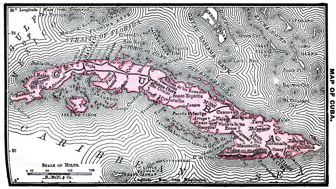
CUBA.Kū´ba.
A Spanish colony in the West Indies. Area, 43,220 square miles. Population, 1,521,684; 50 per cent. of the inhabitants are blacks and enfranchised slaves. The greatest length of the island is 760 miles; width varies from 20 to 135 miles; coast line about 2,000 miles. Surface is broken by a mountain chain running through its centre from east to west; average altitude of summit is between 5,000 and 6,000 feet. Pico de Turquino, 7,670 feet, is the highest peak. There are over 260 rivers, all valueless for navigation purposes, except the Canto. Mineral springs abound.
But little attention has been paid to the development of the mineral wealth. Gold was obtained by the early colonists, but for two centuries comparatively none has been found. There are extensive copper mines, and coal is abundant. Copperas and alum have also been obtained.
Rainfall at Havana: in the wet season, 27.8 inches; dry season, 12.7 inches. Average temperature: at Havana, 77°; at Santiago de Cuba, 80°. Yellow fever and earthquakes are frequent.
Thirteen million acres of Cuban territory are uncleared forests; 7,000,000 wild and uncultivated. Principal woods grown and exported are mahogany, rosewood, Cuban ebony, and cedar.
Tobacco and sugar raising principal occupation of the people. Many sugar plantations comprise 10,000 acres each.
Two crops of Indian corn grown per year; rice, cotton, cacao and indigo also produced; most tropical fruits are abundant. Sugar product averages 520,000 tons per year; molasses, 79,365 hogsheads. Total value of agricultural products over $90,000,000. United States receives 80 per cent. of Cuban sugar. No manufactures deserving mention.
Latest reports give exports of cigars 225,000,000 per annum; leaf tobacco, 13,500,000 pounds. There are about 900 miles of railway. Marine cable connects Cuba with Florida.
Roman Catholicism is the only religion tolerated. Education compulsory; school attendance, 34,813.
Havana is the capital; Pop., 25,000. Government administered by a Captain General, appointed by the Spanish Crown. The island is now represented in the Spanish Cortes, Madrid.
PORTO RICO.Pōr´to Ree´ko.
The smallest of the Greater Antilles. Area, including dependencies, 3,550 square miles. Population, 754,313. Rectangular in shape; length, 100 miles; breadth, 40 miles. A range of mountains extends across the island from east to west; highest peak, 3,678 feet.
The island is very fertile; its principal products are sugar cane, coffee, tobacco, cotton, rice and Indian corn. In proportion to its area, it produces more sugar than any other West India island.
Government is administered under a constitution granted by the Spanish Cortes, 1869. Slavery was abolished in 1873. Capital, San Juan; pop. about 27,000. Climate warm; more healthful than that of the other Antilles. Destructive hurricanes are frequent. The natural productions are very numerous; medicinal plants and many valuable woods, as mahogany, ebony, logwood, and cedar, abound in the forests. Business in the hands of foreigners. Imports, 1871, $17,500,000; exports $15,500,000. Export of sugar, 111,084 tons; molasses, 7,590,915 gallons.
Telegraphic cable connects Porto Rico with other West Indies; telegraph lines connect the principal towns; there are no railroads.
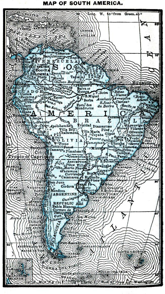
SOUTH AMERICA.
A vast, compact, triangular peninsula, forming southern portion of Western Continent. Area, 6,827,230 square miles; extreme length, 4,550 miles; extreme breadth, about 3,300 miles. Number political divisions, 11.
Divisions. Area, Sq. Miles. Population. Capitals. Pop.
Argentine Republic 1,125,086 3,026,000 Buenos Ayres 295,000
Bolivia 842,729 2,300,000 La Paz 76,372
Brazil 3,288,963 9,883,622 Rio de Janeiro 274,972
Chili 256,399 2,271,949 Santiago 200,000
Colombia 504,773 4,000,000 Bogota 100,000
Ecuador 248,370 946,033 Quito 80,000
Guiana, British 76,000 248,110 Georgetown 36,562
Guiana, French 48,000 36,760 Cayenne 10,000
Guiana, Dutch 46,060 68,255 Paramaribo 27,416
Paraguay 91,970 346,048 Asuncion 16,000
Peru 503,718 2,699,945 Lima 101,488
Uruguay 73,538 438,245 Montevideo 115,500
Venezuela 632,695 2,121,988 Caracas 55,638
PRINCIPAL LAKES.
Maracaybo, area 4,900 sq. miles. Titicaca, area 4,000 sq. miles.
LENGTHS OF RIVERS.
Miles. Miles.
Amazon 3,750 Parana 2,000
Caroni 400 Pilcomayo 1,000
Canca 600 Purus 2,000
Guaviare 450 San Francisco 1,550
Madeira 2,000 Tocantins 1,000
Magdalena 900 Uruguay 800
Meta 500 Xingu 1,300
LATEST REPORTED VALUE EXPORTS.
Cotton: Diamonds:
Brazil $4,063,650 Brazil $370,316
Colombia 32,560
Venezuela 36,449 Tobacco:
Brazil 5,344,500
Paraguay 658,650
Sugar: Venezuela 58,778
Brazil 16,250,000
Peru 2,354,095 Rubber:
Brazil 5,965,000
Ecuador 428,800
Coffee:
Brazil 52,720,000 Hides:
Columbia 2,396,337 Brazil 4,040,750
Venezuela 9,930,430 Colombia 1,000,608
British Guiana 3,019 Venezuela 395,915
British Guiana 11,703
Cocoa: Indigo:
Colombia 15,575 Columbia 8,360
Venezuela 1,602,443 Venezuela 23,290
Ecuador 2,768,670
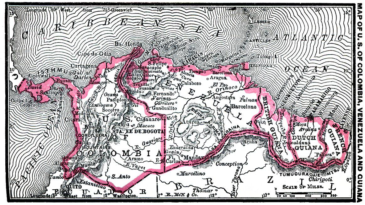
UNITED STATES OF COLOMBIA.
A federal republic in the northwestern part of South America, composed of 9 States. Area, 504,773 square miles. The country is traversed by three ranges of the Andes Mountains. There are numerous large, navigable rivers, tributaries of the Orinoco and Amazon.
The constitution was adopted in 1863. Government in the hands of a President, elected for 2 years, a ministry of 7 members, and a Congress composed of a Senate and House of Representatives. Capital, Bogota; population, 100,000. Strength of the Federal Army determined by Congress. Peace footing for 1882-83, 4,000 men.
The climate varies according to the elevation: the coast lands are usually hot and sickly: but the high table lands, as a rule, possess a genial climate; that of Bogota is unusually fine.
The mineral wealth of Colombia is very great; one-sixth of the exports consist of precious metals. Agriculture and stock raising are the leading pursuits. Value of imports, 1883, $11,504,028; exports, $14,857,170. Two-thirds of the exports consist of cinchona and coffee. The transit trade through the ports of Panama and Aspinwall is of far greater importance than the direct commerce; its value is estimated as not less than $85,000,000 per annum.
There are many native products, among which are fine woods, cacao, India rubber, ipecac, calisaya bark, cochineal, sarsaparilla and logwood. These, and tobacco, cinchona, coffee, sugar, indigo, rice, cotton, hides, ores and Panama hats, form the chief exports.
In 1883, 1,513 vessels, of 709,175 tons, entered the ports of Colombia. Number of miles of railway in the republic, 140. It is expected that the ship canal across the Isthmus of Panama will be opened in 1888. The company have a subscribed capital of $125,000,000.
VENEZUELA.Vĕn´ez-wee´la.
A republic of South America, formed in 1830. The republic was, in 1881, subdivided into 8 States, 1 Federal District, 8 Territories and 2 national settlements. Area, according to an official statement of 1884, 632,695 square miles; population, 2,121,988. The Andes Mountains cross the northern part from west to east; the Orinoco and other important rivers pass through the southern part.
Executive power is in the hands of a President, who exercises his authority through a ministry of 6 and a Federal Council of 16 members; legislative, in a Congress of two Houses, the Senate and House of Representatives. Vice-President chosen by the Council. Capital, Carácas; population, 55,638. Chief towns, Valencia (population, 36,145) and Barquisimeto (population, 28,918). Army: peace footing, 2,545 officers and men; war footing, 350,000.
Mineral resources very great. Venezuela gold fields among the richest in the world; iron and copper abundant. Value of mineral products, 1884, §4,452,050; gold, $3,243,380. Latest reports give value of imports as $17,253,130; exports, $19,720,225.
Agriculture the most important industry. Number engaged in it, 1884, 375,820; number of acres cultivated, 852,500. Coffee the most important product; total value of product, 1884, $11,255,000; value, of sugar product, $7,686,000; corn, $6,000,000; cocoa, $2,998,000. Latest reports give number of cattle as 2,926,733; goats and sheep, 3,490,563; horses, 291,603; mules, 906,467; swine, 976,600.
State religion, Roman Catholic; all others tolerated. In 1883 the government spent $500,000 in public instruction. Number universities, 2; colleges, 33; normal schools, 5; other schools, 1,794. Number of miles of railway, 1884, 102; telegraphs, 1,145 miles.
BRITISH GUIANA.Ghe-a´na.
A territory in northeast part of South America. First settled by the Dutch, 1580. Acquired by the British in 1803; formally ceded in 1814. Estimated area, 76,000 square miles. Population, 248,110. Crossed by two great mountain systems. Contains many rivers; largest, Essequibo, 600 miles long, noted for magnificent cataracts. Thermometer rises to 90° in warm weather; falls to 75° in winter season; mean annual average at Georgetown, 81°. Rainfall per year, about 72 inches.
Vegetation is luxuriant. Large sections are covered with valuable forests, which furnish exhaustless supplies of timber, largely used for shipbuilding. Number sugar plantations, 120; coffee estates, 12. Sugar forms 92 per cent. of exports; latest reports give 111,156 hhds. Rum exported, 32,531 puncheons; rum issued for home consumption, 330,392 gals. Export of molasses, 17,084 casks; timber export, 464,436 cubic feet. Total imports, 1882, $10,498,160; exports, $16,043,155.
Government administered by a Governor appointed by British Crown, and a Court of Policy.
Georgetown the capital; pop., 36,562. Number of schools sanctioned by Board of Education, 177; Church of England, 81.
DUTCH GUIANA.Ghe-a´na.
Lies east of British Guiana, often called Surinam from the river of that name. Coast line, 220 miles. Dutch first visited the country about 1580; but the first settlement in Surinam was made by an Englishman, in 1630. Area, 46,060 square miles. Population, 68,255; 54,602 negroes.
Local government consists of a Governor and Colonial Assembly. Capital, Paramaribo; population, 27,416.
Mean annual temperature, 80.4°; coldest month mercury falls to 78°; warmest, mercury rises to 99°. Rainfall, 99 inches; at Paramaribo the average of eight years was 101 inches.
Large tracts of territory covered with primeval forests. Great staple of Guiana is sugar; average yearly export, about 10,645 tons. First cocoa sent to Amsterdam, 1733; the average yearly production is now more than 13,000 tons. Cotton and coffee rank next. Gold-mining is a growing industry. Latest reported value of exports, $1,151,070; imports, $1,316,355.
FRENCH GUIANA.Ghe-a´na.
East of Dutch Guiana. Area, 48,000 square miles. Population, 36,760. Coast line low and swampy. Large portion of the territory is covered with dense forests. Rainy season from November to June. Rainfall at Cayenne, 10 feet per year; heavier in the interior. Temperature: in summer, 86°; winter, mean, 79°, and seldom sinks so low as 70°. In this century there have been three earthquakes.
Administration in the hands of Governor and Military Commandant.
Capital, Cayenne; pop., 10,000.
Coffee, introduced in 1716, is extensively grown. Guiana cocoa, bread-fruit, arrow-root, bananas, yams, oil, and date palm are among the products; but the principal source of food is manioc. Contains valuable gold deposits. French criminal penitentiaries located in this country.
BRAZIL.Bra-zil´.
This is the largest of the South American countries, and the only empire in the New World. Contains many rivers. Amazon, the longest, drains 800,000 square miles of Brazilian territory. Temperature in the valley of the Amazon ranges from 68° to 85°, while at Rio Janeiro the average is 75°. Area, 3,288,963. Population, 9,883,622. Capital, Rio de Janeiro; pop., 274,972.
Executive power is vested in the Emperor, ministers and Secretaries of State; legislative authority rests with the Senate and and Chamber of Deputies. The empire is divided into 20 Provinces.
Country rich in minerals and precious stones. Total value of diamond washings for the first 100 years was about $20,000,000. Diamond mines are now owned by private individuals. Manufactures in late years improved by the introduction of American machinery.
During the last 16 years the increase in exports has been 20 per cent.; in imports, 22 per cent. The value of coffee exported in 1882-83 was $52,720,000; sugar, $16,250,000; raw cotton, $4,063,650; tobacco, $5,344,500; India rubber, $5,965,000. Total imports, 1882-83, $111,434,300; exports, $134,945,100. In 1883, 2,989 vessels, of 2,367,296 tons, entered, and 2,522, of 2,095,237 tons, cleared, Brazilian ports.
Number miles railway, January, 1884, 3,500; 1,500 in process of construction. Telegraph system under the control of the government; miles of wire in 1883, 4,900. Army, on peace footing, 13,500 strong; in time of war, 32,000. Naval force consists of 35 steam vessels, with 123 guns and 5,704 seamen.
Established religion, Roman Catholic. Clergy are supported by the state. Compulsory education exists in several Provinces; 84 per cent. of population is illiterate. Total number of schools, 5,685.
BOLIVIA.Bo-liv´e-a.
A republic of South America, named in honor of Simon Bolivar; formed, in 1825, from provinces of Upper Peru; ceded all coast territory to Chili in 1880. Area, 842,729 square miles. Population, 2,300,000. Surface broken by two mountain ranges. Highest peak, Sahama, 22,350 feet; many volcanoes. Lake Titicaca is the largest inland body of water in South America; area, 4,000 square miles; Madeira river, with tributaries, navigable for 3,000 miles in Bolivia; La Paz chief city; pop., 76,372. Capital, Sucre or Chuquisaca.
President elected for 4 years. Legislative power rests with a Congress of 2 chambers,—Senate and House of Representatives. Universal suffrage prevails; Vice-President is appointed by President.
The climate embraces all degrees of heat and cold. The products of two zones are found in Bolivia. Ebony, rosewood, mahogany, cinchona, and other valuable trees abound. Manufactures limited to coarse cotton cloth, hats, cordage, leather and alpaca. Tin, copper, gold, and vast quantities of India rubber of the finest quality abound. Silver mines almost inexhaustible; annual yield of the Cerro de Potosi mines, $2,250,000. Two-thirds of exports are silver. Imports average $6,150,000; exports, $9,000,000.
Standing army, 2,421 men; generals and other officers, 1,021; two-thirds of revenue goes to support the army.
Roman Catholic the prevailing religion; other creeds tolerated; 4 universities. In 1884 but 12,000 pupils and students at schools and colleges. Three railroads open for traffic.
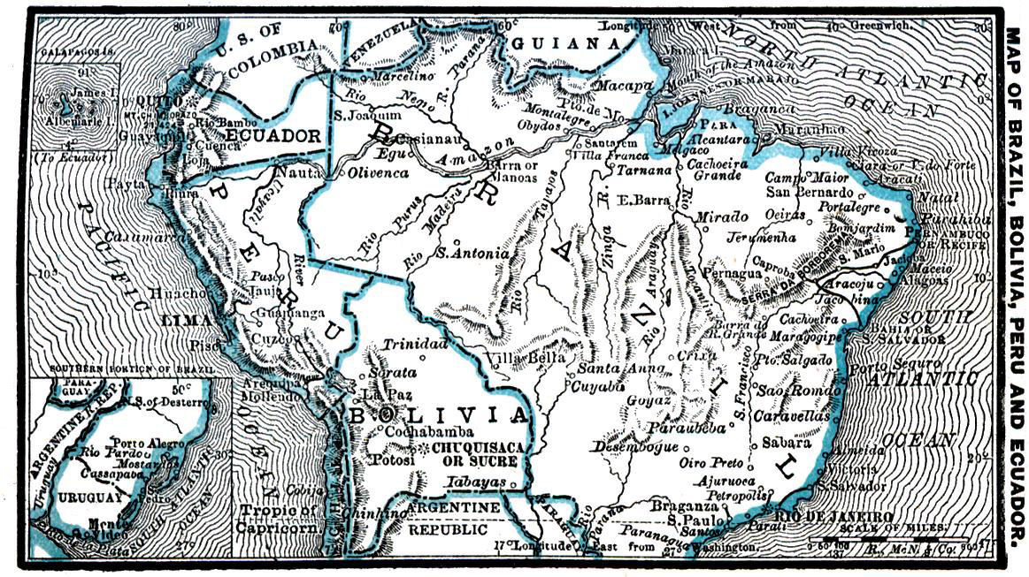
ECUADOR.Ek-wa-dōr´.
A republic of South America, constituted 1830; situated on the equator, from which it takes its name. Extremely mountainous; traversed from north to south by three ranges of the Andes. Most lofty peaks: Cotopaxi, 18,880 feet; Chimborazo, 21,424; Cayambe, 19,831. Climate, on the coast, hot; on the high table lands, cold and bleak; valleys are free from extremes of temperature. Area, 248,370 square miles. Population, 946,033. Quito, the capital, has 80,000 inhabitants; Guayaquil, the principal seaport, 26,000. Quito is the highest inhabited city, being 9,500 feet above sea-level.
Ecuador was formed from the American Free State, founded by Simon Bolivar. Executive power rests with a President, elected for 4 years; legislative, with a Congress of two houses. President and Vice-President are nominated by 900 chosen electors. Vice-president is President of the Council of State. Hereditary rights or privileges prohibited by law. Belief in the Roman Catholic church, qualification for suffrage.
The soil of Ecuador will grow the products of every zone. There is a copious growth of the cinchona tree, sarsaparilla, vanilla, copaiba, balsam of Tolu, etc. Many fibrous plants, suitable for the manufacture of paper and cordage, are found in profusion. The immense mineral wealth is untouched; agriculture is neglected; manufactures are insignificant. The roads afford no facilities for commerce, being mostly mule tracks. Miles of railway number but 75.
Export of cocoa, 1883 valued at $3,372,200; India rubber, $428,800. Total value of exports, $4,923,300; imports, about $6,000,000. In 1883, 151 vessels, of 155,283 tons, entered, and 160 vessels, of 158,970 tons, cleared the port of Guayaquil.
Only 7.5 per cent. of population can read or write. In 1884, standing army fixed at 1,600 men.
PERU.Pe-roo´.
A republic of South America. Area, previous to the war with Chili, 503,718 square miles. Population, 2,699,945. Since the war about 70,000 square miles of Peruvian territory are occupied by Chili. Traversed by two systems of the Andes Mountains; highest point is the volcano of Misti, 20,300 feet above sea-level. Temperature at Callao about 60°; Lima about 70°.
Independence declared in 1821. The government is administered by the President, Senate and House of Representatives. The Peruvian constitution is planned after that of the United States. Lima, the capital, has a population of about 100,000.
The chief occupations are sheep raising, agriculture and mining; manufactures unimportant. Mountain valleys are very fertile; mountains are rich in minerals. Between 1853 and 1872, 8,000,000 tons of guano were taken from the Chincha Islands. Latest reliable reports give: imports, $24,000,000; exports (exclusive of guano and nitre), $31,000,000. Principal exports are guano, nitrate of soda, wool, sugar, silver and cinchona.
State finances deranged by the late war with Chili; foreign debt $164,765,000; arrears in interest, $65,954,970. Railway system projected in 1852; miles of line, 1878, 2,030. Telegraph lines, 1878, 1,382 miles. The merchant marine, 1877, consisted of 147 vessels, with a combined capacity of 49,860 tons. Army and navy almost annihilated in the war with Chili; army now consists of 13,200 men; navy, of 18 steam vessels, with 66 guns.
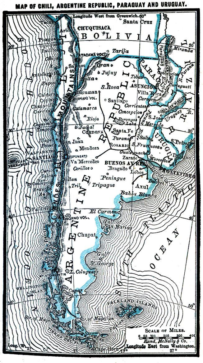
ARGENTINE REPUBLIC.Ar´jen-tine.
A republic of South America. Total area, 1,125,086 square miles. Total population, 1882, 3,026,000. Foreigners: Italians, 123,641; French, 55,432; Spaniards, 59,022; Germans, 8,616; English, 17,950. Population of Buenos Ayres, the capital, was, in 1882, 295,000; Rosario has a population of 32,204; Cordova, 39,651; ten towns have over 10,000 inhabitants. Population rapidly increasing from immigration. In 1877 immigrants numbered 28,708; 1880. 41,615: 1882, 59,843; during first nine months of 1883, 73,210. The country is divided into 14 Provinces. Executive power is vested in a President, elected for a term of 6 years; legislative power is vested in a Congress, composed of a Senate and House of Deputies. President and Vice-President must be Roman Catholics. Constitution almost identical with that of the United States.
Public revenue derived from heavy customs duties. Income for 1884, $32,400,000; Import does, $21,115,000; export dues, $3,010,000; total expenditure, $32,460,000. Annual exports: wool, $28,250,000; hides, $14,000,000; sheep skins, $4,250,000; tallow, $6,000,000; live animals, $1,750,000; maize, $2,100,000.
The area devoted to agriculture is yearly increasing. In 1882 the confederation possessed 14,206,499 horned cattle, 72,683,045 sheep, 4,856,808 horses. Total value of live stock, $210,000,000. In 1882 the wheat product of the province of Santa Fé was 2,250,000 bushels.
Miles of railway, 2,500, and 651 miles are being constructed. In 1884 there were 9,800 miles of telegraph line, 8,060 miles owned by the state.
Many navigable rivers afford excellent facilities for transportation. The Uruguay river is navigable for 200 miles; the Rio Negro, for 500; and the Colorado, for 150.
There are universities at Buenos Ayres and Cordova; professors, 66; students, 923: there are also 28 middle class and normal schools, and 1,985 primary.
The army in 1884 consisted of 7,812 officers and men; militia and National Guard, 350,000. Service in National Guard compulsory; regular army supplied by recruitment.
URUGUAY.Oo-roo-gwī´.
This South American republic formed a Brazilian Province until 1825. Independence recognized by treaty of Montevideo, 1828; constitution proclaimed 1831. Area estimated at 73,538 square miles. Population, 438,245. Government in the hands of a President, elected for four years, assisted by 5 ministers, and a Parliament composed of two houses. Capital, Montevideo; population, 115,500.
The country forms a vast rolling plain, abounding in natural pastures. The chief industry is the rearing of cattle and sheep. It is estimated that 35,000,000 acres are used for pastoral purposes, on which are 6,711,778 cattle and 20,000,000 sheep. Chief agricultural products, wheat and Indian corn. Climate is generally humid, but temperate and healthful.
Revenue derived from customs duties. Commerce active. Value of imports, 1833, $21,634,475; exports, $26,831,555. Principal articles of export, cattle, hides, tallow, and dried and preserved meats.
Permanent army numbers 3,494 men, besides an armed police force of 3,200, and a national guard of 20,000 men. State religion, Roman Catholic. Number of children in all schools, 40,000. Miles of railway, 1884, 271; of telegraph, 1,405.
CHILI.Chil´lee.
A republic of South America. Area, 256,399 square miles. Population, 2,271,949. This country is long and narrow, embracing extremes of temperature. Mean annual temperature at Santiago, 55°; at Valparaiso, 58°. Spring begins in September; winter, in June. Lakes and rivers are few; both are fed by the snow melting in the Andes; they are worthless for navigation, but valuable for irrigation purposes. Surface is mountainous; mean elevation of Andes, 11,830 feet; Aconcagua, the highest peak, 22,420 feet.
Chili is divided into 18 Provinces and 4 Territories. The constitution of 1833 vests the legislative power in a Senate and a Chamber of Deputies. Executive power rests with a President, a Council of State, and a Cabinet of 5 ministers. Capital, Santiago; pop., 200,000. The potato is indigenous. Olive trees, mulberries and vines flourish. Cedar is the most important tree in Chili. Fruit is plentiful. This republic is rich in gold and silver, and especially in copper. Wheat the most important cereal product; value of wheat exported in 1882, $6,649,345. Value of chief exports in 1883: iodine, $2,987,490; bar copper, $14,339,460; silver, $4,624,110. Revenue for 1884, $49,900,000, one-half of which was derived from customs duties and monopolies; expenditure, $46,536,550. Total exports in 1883 were valued at $79,732,550; imports, $54,447,060.
The Chilian commercial marine consisted, 1883, of 131 vessels, of 53,071 tons. In 1882, 1,482, of 1,367,849 tons, entered, and 1,428, of 1,431,028 tons, cleared, the various ports of Chili.
One of the first states in South America to construct railways; length of line in 1883, 1,378 miles, of which 600 miles belonged to the state; cost of state lines, $42,141,686. In 1883 there were 6,840 miles of telegraph line, property of the state. By a law of 1884 the strength of the army can not exceed 12,410; at the same date the National Guard numbered 51,826, of whom 17,408 were on duty. Navy consists of over 20 war vessels.
State religion is the Roman Catholic; all creeds are protected; clergy is subsidized by the state; civil marriage is acknowledged by law. Besides the National Institute at Santiago, there are many colleges of different kinds; many agricultural and other special schools. There were, in 1883, 5,042 students attending universities and colleges. The attendance at the 724 public primary schools was 60541
PARAGUAY.Pa-ra-gwā´.
A republic of South America, entirely inland. Area 91,970 square miles. Population, 346,048. Became independent in 1811; was ruled by Dr. Francis for 25 years. The government is entrusted to a President and Congress. Capital, Asuncion; pop., 16,000.
Soil and forests are very great sources of wealth. Manufactures are few and crude. The country is well watered by numerous streams and lakes. Three crops of tobacco per year are grown; home consumption, 15,000,000 lbs.; export, about 7,500,000 lbs. Sugar cane yields well; in 1882 there were 37,500,000 pounds of sugar produced. Maize returns one hundred and forty fold; rice, two hundred and fifty fold. Maté, or Paraguayan tea, the most important product. Imports, 1881, $1,278,000; exports, $1,928,500. The state owes Brazil and allies $236,000,000; Foreign debt, $17,315,000.
Army numbers 607 men, lately reduced in order to diminish expenses. Railway, 45 miles; telegraph, 45 miles.