MOUND INVESTIGATION ON THE EAST COAST OF FLORIDA
Reading edition
Our investigation of aboriginal mounds on the east coast of Florida, south of St. Johns County, occupying three months of the Winter of 1895-1896, included such territory as borders the Halifax river; the Hillsboro’ river, including the Mosquito lagoon; the Indian river and Lake Worth; as well as the tributary streams, Tomoka creek, Spruce creek, Banana river and St. Lucie river.
In addition, certain mounds in the neighborhood of the town of Fernandina were examined and the St. Mary’s river, separating portions of Florida and of Georgia, was gone over so far as the head of navigation. To this work additional time was devoted.
The Halifax, Hillsboro’ and Indian rivers, so-called, are not rivers strictly speaking, but long and comparatively narrow stretches of salt water, connected with the Atlantic Ocean by various inlets and separated from the sea by a comparatively narrow strip of sand, at no place five miles in breadth. They extend north and south and their total length in a direct line is about 187 miles.
The Banana river is simply a portion of the Indian river, lying east of Merritt’s Island.
Tomoka and Spruce creeks and St. Lucie river, at a certain distance above their outlets, are fresh water streams.
The aboriginal mounds bordering the Halifax, Hillsboro’ and Indian rivers, while examined with considerable care, were by no means so exhaustively investigated by us as have been the mounds of the St. Johns river and of other parts of Florida, and our conclusions must not be regarded as final but rather taken as indications.
It would seem that the mounds of this region, considerable in number and some of great size, were mostly erected for other than sepulchral purposes, inasmuch as human remains appear to be absent from the bodies of the mounds though in some cases numerous interments were present near the surface, sometimes associated with art relics of European manufacture, such as glass beads, silver beads and the like.[1] These burials we look upon as intrusive, made by Indians coming later than the makers of the mounds.
In certain cases smaller mounds contained human remains down to the base, but in every case these remains, where any other objects were found at all, were associated only with bits of shell or of coquina.
Mr. Andrew E. Douglass, of the Museum of Natural History, New York, who has spent a number of seasons on the east coast and has published various valuable papers descriptive of his work,[2] reached virtually the same conclusions as ourselves, and we are strongly of opinion that a more thorough investigation of these mounds, though earnestly to be desired, will not be fruitful of results.
Another point strongly impressing itself upon us was the almost entire absence of stone (unless coquina[3] may be so termed) in the territory bordering the Halifax, the Hillsboro’ and the Indian rivers, the mounds being entirely free from chips, cores, and other refuse material of chert so abundant in mounds of the St. Johns river.
Large fields of shell, denoting aboriginal dwelling sites, are numerous, yet upon them we found not a single arrowhead or fragment of hard stone, while persons cultivating these fields invariably expressed ignorance as to the discovery of stone upon them. Upon similar fields and shell heaps of the St. Johns arrowheads and flint chips are abundant; this absence of stone on the east coast is certainly worthy of remark considering its comparative abundance on a river not over thirty, and at one point only five, miles away.
Mr. Douglass has remarked the absence on the east coast of the polished stone hatchet, or “celt,” from mounds south of St. John County, or about where the Halifax river begins, and we have not in our experience learned of the occurrence of this implement on the east coast south of the point referred to by him, though on the St. Johns river a number were taken by us from Thursby Mound, about twenty-seven miles farther south, while one small hatchet was found on the surface not far north of Lake Monroe. Beyond this point, even on the St. Johns, the stone “celt” seemed to be absent with the exception of one rude cutting implement of the polished “celt” type[4] taken by us from the island shell heap known as Mulberry Mound, situate where the St. Johns river leaves Lake Poinsett, about six miles west of Cocoa on the Indian river.
As we have said, exhaustive work was not done by us on the east coast and as various lists of the earthworks of that section have already appeared, we shall not go into a detailed account but shall give results obtained in certain of the mounds examined by us which, so far as our investigation has extended, were typical of the whole.
Stone House Mound. Mounds at Courtenay (2). Mound at De Soto. Mound at Tropic. Gleason Mound. Low Mounds near mouth of Banana river (2). Mound near St. Lucie river.
Stone House Mound, Volusia County
Spruce Creek enters the Halifax river opposite the town of Ponce Park. About 1 mile up Spruce Creek, turning into Murray’s Creek and following the stream about 1 mile, the Murray dwelling is reached, from which the mound is distant about 1.5 miles inland, in a southwesterly direction. The mound, in thick “hammock,” and covered with palmetto and other trees, has a height of 20 feet, a diameter at base of 144 feet. The trench made by Mr. Andrew E. Douglass,[5] was the only previous investigation apparent on the mound.
Parts of two days, with nine men to dig, were devoted to investigation. Neither burial nor artifact rewarded our labors—a result similar to that attained by Mr. Douglass.
Two feet beneath the surface, such parts of the mound as were dug into by us, were encased in heavy slabs of coquina. This curious feature was noted also by Mr. Douglass in the portion investigated by him.
Mound at Courtenay, Brevard County
The settlement of Courtenay, on Merritt’s Island, which here forms the eastern shore of the Indian River, is about eight miles north of the town of Cocoa.
On the property of Mr. John H. Sams, at Courtenay, is a mound which was cordially placed at our disposal for investigation by the owner. The mound, entirely surrounded by a trench, presents a striking appearance, giving the impression of greater altitude than it really possesses. Its height is 11 feet; its diameter at base about 100 feet, making allowance for a certain amount of sand evidently washed from the mound.
An excavation 28 feet in diameter and from 5 to 6 feet deep, was made in the central portion of the mound. A few scattered human bones were present immediately below the surface. At a depth of 5 feet was a sherd of considerable size. Loose in the sand was one fragment of chipped chert. Beyond these, nothing was encountered and the sand, coarse and yellow, had the raw look peculiar to mounds containing no organic remains.
Low Mound at Courtenay, Brevard County
In the southern extremity of the settlement of Courtenay, in thick “hammock” land, on the property of Mr. H. J. Tiffin, of Montreal, Canada, was a mound about 2 feet in height and 35 feet in diameter. The central portion of this mound was completely dug through at the courteous invitation of the owner. At two points were fragmentary human remains which, with one small sherd, were the entire yield of the mound.
Mound at De Soto, Brevard County
The Banana river, as we have stated, is simply a portion of the Indian river separated from the main body by Merritt’s Island. On the east side of the river, about 7 miles south of its northern extremity, at or near De Soto, is the estate of Mr. F. Y. Hanna, an unoccupied house with a landing. About one-half mile in a northeasterly direction from the landing, on Mr. Hanna’s property, is an irregular mass of sand 6 feet 4 inches in height and 75 feet across the base. An excavation made in the center, 18 feet by 24 feet by 4 feet deep, yielded four burials in anatomical order, none over 18 inches from the surface. With one skeleton were two bits of looking-glass, with another was a fragment of conch-shell. About one foot from the surface were parts of an undecorated bowl. This mound, at a short distance below the superficial portion, was composed of that raw-looking bright yellow sand, in which, as we have stated, we have never yet met with interments.
Mound at Tropic, Brevard County
Near the southern extremity of Merritt’s Island is the settlement of Tropic. On the property of Mr. M. F. Dwyer, of New York, in a cultivated pineapple patch, was a symmetrical mound of white sand, 3 feet 8 inches in height and 48 feet across the base. It was practically demolished. No stratification was noticed. A considerable number of fragmentary human remains, very badly decayed, including a number of isolated crania, were present at all depths. A number of bits of plain earthenware and several stamped in squares, were loose in the sand.
Eight small shells (Dosinia discus) were found together, while masses of coquina and smaller bits were present in the mound. An occasional fragment of Fulgur was met with. Beyond this, greatly to our disappointment, for the mound had a very promising appearance, nothing was discovered.
Gleason Mound, Brevard County
On the eastern bank of the Banana river, a short distance above its union with the Indian river, in full view from the water, is a great shell-heap mainly composed of the shells of marine bivalves (Dosinia discus), a section of which has been laid bare by the river. In the “scrub,” about one-eighth of one mile in a northerly direction from this heap, is a mound on the property of ex-Governor Gleason, of Eau Gallie, who courteously placed it at our disposal.
The mound, which is not symmetrical and had suffered from much superficial investigation, has a height of about 10 feet and a diameter at base of about 150 feet.
The mound, which was thickly covered with undergrowth, was cleared by us near the center of the summit plateau, giving a space about 32 feet in diameter, which was dug through to a depth of from 5 to 7 feet. In addition to this, considerable work was done on the northern and eastern slopes.
The sand, whitish in color, was unstratified.
Burials—all superficial and all in anatomical order—were numerous, about thirty being met with.
With the majority of the bodies no relics were found. With others were flat bits of coquina; portions of clam shells, showing wear, and occasionally a mass of coquina.
Near human remains were three large glass beads and a round bead of silver, apparently of European make.
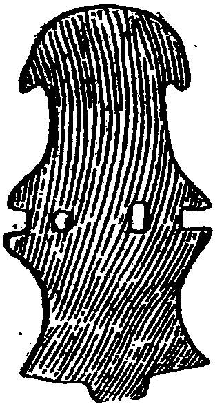
Fig. 4.—Ornament of silver. Gleason mound. (½ size.)
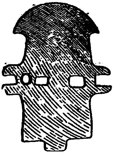
Fig. 5.—Ornament of brass. Gleason mound. (½ size.)
With a burial about two feet from the surface was a small gorget of silver, oxidized, having three perforations, two apparently made with a sharp cutting tool, the other bored from one side and countersunk (Fig. 4), representing the head of a duck.
With another superficial burial, lying near the lower jaw, was a somewhat similar ornament of brass (Fig. 5).
Ornaments of this type are not uncommon in Florida, though we have met with none on the St. Johns.[6]
Loose in the sand throughout the mound were a few bits of ornamented earthenware; one Fulgur carica, much worn at the beak, but without the usual perforation; and one large marine shell (Fasciolaria). A considerable number of these shells, all more or less broken as to the body whorl, lay near previous excavations.
Five feet from the surface were the remains of an undecorated bowl of considerable size, which had been interred whole or nearly so. No human remains were found in the neighborhood of this bowl, and it lay at a much greater depth than any other discovered by us. It had probably been lost or broken during the construction of the mound.
From the eastern slope, with human remains, were taken two imperforate drinking cups of shell, one within the other; another alone; and two beads of silver seemingly of European workmanship.
As no burials or indications of interment (and discoloration of sand usually shows where bones have been) were met with in the Gleason mound at a depth of over 2 feet, we are of opinion that later Indians utilized for burial a pre-existing mound.
Mounds near Mouth of Banana River, Brevard County
On the property of Mr. John Aspinwall, of New York, about one-half mile south of the Gleason mound, 50 yards apart approximately, were two mounds in thick “scrub.”
The smaller mound, about 4 feet in height, was dug through as to the central portion, yielding a number of superficial burials of the bunched variety. With some of these were small bits of coquina and of shell.
The larger mound, about 7 feet in height, yielded nothing to an investigation conducted through the central portion.
Mounds near St. Lucie River, Dade County
About one and one-half miles above the railroad bridge, or six and one-half miles, approximately, from the river’s mouth, near the southern bank of the south fork of the St. Lucie River, is a mound in the pine woods in full view from the stream.
Its height is about 6 feet above the general level on the south and west, while on the other two sides deep depressions, made by the removal of sand for the mound, give it the appearance of much greater altitude.
The diameter of its base is about 80 feet.
A considerable section was dug out from near the margin to the center and the base of the central portion was carefully explored.
Several superficial burials were met with toward the center and two at different points about 3 feet from the surface.
With the remains were no artifacts whatsoever.
Loose in the sand, separately, were two fragments of undecorated earthenware, two bits of Hematite and a number of pieces of charcoal.
At Spruce Bluff, up the north fork of the St. Lucie river, is a large mound which we did not investigate. Considerable digging had been attempted in the central upper portions. Residents reported no discoveries during these investigations.