Yellowstone National Park
Reading edition
Location: Northwestern Wyoming, southern Montana, and eastern Idaho. Area: 3348 square miles. Season: June 20 to September 15. Address of supervisor: Yellowstone Park, Wyoming.
Railroad Connections
Yellowstone Park is reached by railroads on three sides—on the north by the Northern Pacific, on the west by the Oregon Short Line, and on the east by the Chicago, Burlington & Quincy.
The following rates apply to all entrances or entering via one entrance and leaving via another: Chicago, $47.50; St. Paul, $39.50; St. Louis, $44.50; Kansas City, $37.00; Seattle, $33.15; San Francisco, $66.25.
The Northern Pacific Railway reaches the Park at Gardiner, the northern entrance, by way of a branch leaving the main line at Livingston, Montana. Side trip from Gardiner, $3.00.
The Oregon Short Line reaches the Park at Yellowstone, Montana, the western entrance. This line makes connection with transcontinental roads passing through Salt Lake City or Ogden, and with the Chicago, Milwaukee & St. Paul at Butte, Montana. Round trip in connection with through tickets Salt Lake City or Ogden or Butte to Yellowstone, $12.25. Connection may also be made at Butte with the Northern Pacific Railway.
The Chicago, Burlington & Quincy reaches Cody, Wyoming, 63 miles from the eastern entrance by a good automobile road. All tickets from eastern points on the Burlington system are honored via Cody to the Park boundary without extra charge.
Tourists holding transcontinental tickets via the Great Northern may make the side trip to Yellowstone Park for $15.70 (see p. 428) additional.
Tickets including transportation to Denver, Yellowstone Park, and Glacier Park are sold at the following rates: Chicago, $58.00; St. Louis, $55.00; Kansas City, $47.50.
Coupon tickets may be purchased covering railroad transportation, accommodation at hotels or camps, and automobile transportation in the Park.
Automobile Routes
From the Lincoln Highway the Park may be reached by two routes—on the east from Cheyenne, Wyoming, and on the west from Ogden, Utah. The route from Cheyenne passes through Chugwater, Wheatland, Douglas, Casper, Lost Cabin, Thermopolis, Worland, Basin, and Cody to the eastern entrance, the total distance being 541 miles. From Ogden the route leads through Pocatello and Idaho Falls to Yellowstone, Montana, the western entrance. The distance by this route is 324 miles.
From the Yellowstone Trail the Park may be reached from Billings via Cody to the eastern entrance (175 miles); Livingston to Gardiner, northern entrance (55 miles); Bozeman to Yellowstone, western entrance (93 miles); Butte to Yellowstone, western entrance (170 miles).
Automobiles entering the Park are required to pay $7.50 for a single trip or $10.00 for a season permit. Speed limits range from 8 to 20 miles per hour.
Hotels and Camps
The Yellowstone Park Hotel Company operates hotels at Mammoth Hot Springs (Mammoth Hotel), Upper Geyser Basin (Old Faithful Inn), Yellowstone Lake (Lake Hotel), and Grand Cañon (Grand Cañon Hotel). It also maintains a lunch-station at Pahaska on the road to Cody. The rates at the hotels are $6.00 per day for rooms without bath. The Fountain Hotel at Lower Geyser Basin is not open.
The Yellowstone Park Camping Company operates permanent camps at Mammoth Hot Springs, Upper Geyser Basin, Yellowstone Lake, Grand Cañon, and Tower Falls. The rate at the camps for the regular 5-day trip through the Park is $18.00. Rates per day range from $3.25 to $4.00, according to the class of tents.
Transportation
The familiar Concord coaches that were for so many years a feature of travel in the Yellowstone have been discontinued and transportation is now by means of automobile stages. All the transportation is furnished by one corporation, the camping companies no longer operating coaches as was the practice before the consolidation. The automobiles will make the circular tour in 2 days, but this allows no time for seeing anything at the hotels or camps. Coupon tickets covering hotel and transportation within the Park are not sold for less than a 5-day trip.
The regular tour of the Park by the automobile stages costs $25.00. Surreys may be obtained for drives at the important points, but it is far more satisfactory to walk, as the distances are not great.
The hotels will furnish guides for $5.00 per day and saddle horses for $3.50 per day. The camps will supply saddle-horses for $3.00 per day, and guides for $4.50.
Principal Points
The places generally visited are Mammoth Hot Springs, the Upper Geyser Basin, Yellowstone Lake, the Grand Cañon of Yellowstone River, and Mount Washburn. All these points lie on the main road system that is traversed by the automobile coaches. The distances along this route are as follows:—
Points of interest and distances on circular tour on main road from Gardiner, Montana, northern entrance
Miles
Mammoth Hot Springs (Mammoth Hotel, permanent camp)5
Hoodoos and Silver Gate8
Golden Gate and Rustic Falls9
Swan Lake10
Willow Park14
Apollinaris Spring15
Obsidian Cliff17
Beaver Lake17½
Roaring Mountain20½
Twin Lakes21
Bijah Spring22
Fryingpan23
Norris Geyser Basin25
Elk Park27
Gibbon Meadows28
Artists (Gibbon) Paint Pot29
Gibbon Cañon29½
Beryl Spring30
Soda and Iron Springs33
Gibbon Falls (80 feet)33½
Cañon Creek34
Road to western entrance35
Cascades of Firehole River } 39½
Road to western entrance
Nez Percé Creek43
Lower Geyser Basin45
Excelsior Geyser48
Biscuit Basin51
Upper Geyser Basin (Old Faithful Inn, permanent camp)54
Kepler Cascade56
Lone Star Road57½
Continental Divide62½
De Lacy Creek63½
Shoshone Point64½
Continental Divide69½
Lake View } 72
Duck Lake
Thumb of Yellowstone Lake73
Arnica Creek78½
Natural Bridge} 84½
Bridge Creek
Yellowstone Lake (Lake Hotel permanent camp)89
Lake outlet90
Mud Volcano96½
Grotto Springs97
Hayden Valley100
Alum Creek102
Grand Cañon of the Yellowstone River (Cañon Hotel, permanent camp) 105
Dunraven cut-off112
Top of Mount Washburn116
Tower Falls Road119
Tower Falls (132 feet)125½
Permanent camp127½
Petrified trees128½
Blacktail Deer Creek140
Lava Creek, Undine Falls (60 feet)143
Mammoth Hot Springs148
Gardiner153
Click on the map to enlarge it
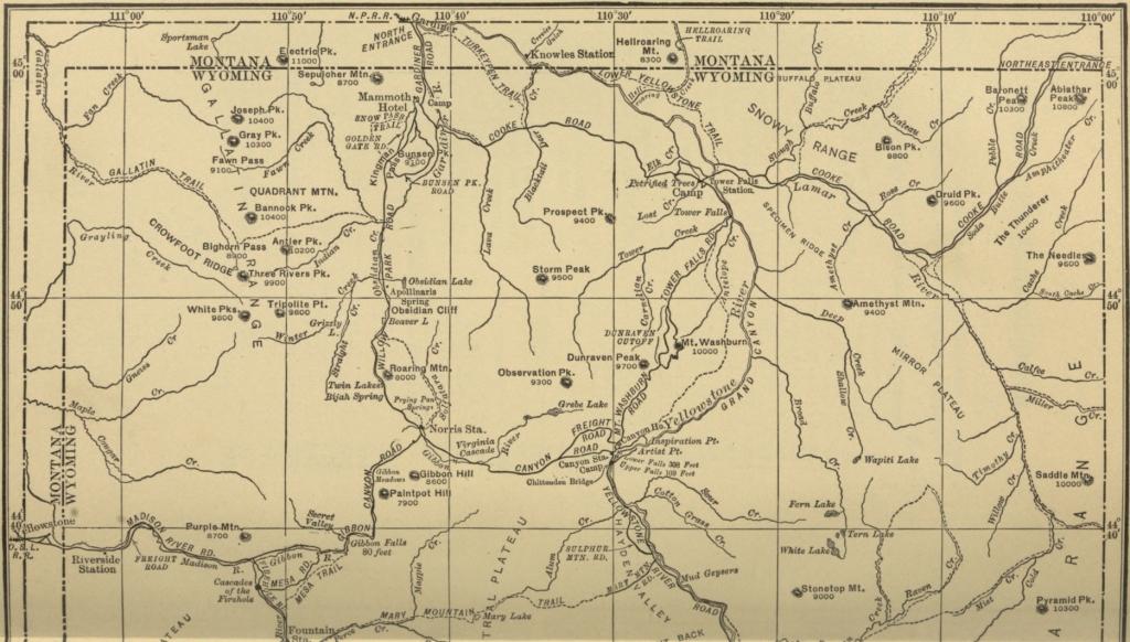
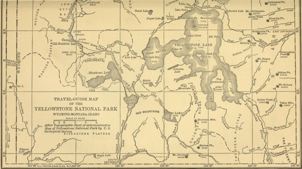
By permission of the National Park Service, Department of the Interior
TRAVEL-GUIDE MAP OF THE YELLOWSTONE NATIONAL PARK
WYOMING-MONTANA-IDAHO
Distances from Yellowstone, Montana, western entrance, to main road
Miles
Via Cañon Creek:—
Ranger Station3
Junction of Gibbon and Firehole Rivers13
Cañon Creek, main road. (This point is 35 miles from Gardiner; for distances beyond this point see table of distances from Gardiner)17
Via Firehole River:—
Cascades of the Firehole River direct via road up Firehole River. (This point is 39½ miles from Gardiner; for distances beyond this point see table of distances from Gardiner)15½
Points of interest and distances from Cody, Wyoming, via eastern entrance to main road
Miles
Eastern entrance63
Sylvan Pass71
Sylvan Lake72
Cub Creek76
Turbid Lake83
Lake outlet, main road. (This point is 90 mile from Gardiner; for distances from this point see table of distances from Gardiner)91
Points of interest and distances from Jackson, Wyoming, via southern entrance, to main road
Miles
Southern entrance25
Lewis Falls (upper, 80 feet; lower, 50 feet)34
Lewis Lake, south end36
Trail to Shoshone Lake41
Continental Divide43½
Thumb of Lake, main road. (This point is 73 miles from Gardiner; for distances beyond this point see table of distances from Gardiner)48
Mammoth Hot Springs
Here are located the famous terraces, the Mammoth Hotel, the abandoned army post of Fort Yellowstone, and the headquarters of the Park Supervisor. The terraces are near the hotel, and the tourist will have no difficulty in finding his way over them. The principal ones are Minerva, Mound, Pulpit, Jupiter, Angel, Cleopatra, and Hymen. Near the southwest end of the terraces is the Devil's Kitchen—a cave which may be visited. Another peculiar rock formation beyond the Devil's Kitchen is the mass of travertine known as the White Elephant.
Upper Geyser Basin
The Upper Geyser Basin contains more active geysers than all the other geyser regions in the world. Several days might well be spent roaming among the geysers and observing the varied phenomena.
The more important ones are listed in the table on page 439.
GeyserHeight (feet)Duration of eruptionInterval
Artemisia 50 10 to 15 minutes 24 to 30 hours
Bee Hive 200 6 to 8 minutes 3 to 5 times at 12-hour intervals following Giantess
Castle 50-75 30 minutes 24 to 26 hours: quiet 4 to 7 days, then plays 3 or 4 times at intervals stated
Cub, large 60 8 minutes With Lioness
Cub, small 10-30 17 minutes 2½ hours
Daisy 70 3 minutes 85 to 90 minutes
Fan 15-25 10 minutes Irregular
Giant 200-250 60 minutes 6 to 14 days
Giantess 150-200 12 to 36 hours Irregular; 5 to 40 days
Grand 200 15 to 30 minutes Irregular; 1 to 2 days
Grotto 20-30 Varies 2 to 5 hours
Jewel 5-20 About 1 minute 5 minutes
Lion 50-60 About 2 to 4 minutes Irregular; usually 2 to 17 times a day
Lioness 80-100 About 10 minutes Irregular
Mortar 30 4 to 6 minutes Irregular
Oblong 20-40 7 minutes 8 to 15 hours
Old Faithful 120-170 4 minutes 60 to 95 minutes
Riverside 80-100 15 minutes 6 hours
Sawmill 20-35 1 to 3 hours Irregular; usually 5 to 8 times a day
Spasmodic 4 20 to 60 minutes Irregular; usually 1 to 4 times a day
Turban 20-40 10 minutes to 3 hours Irregular
The following springs are well worth a visit:—
Black Sand Spring (about 55 by 60 feet).
Chinaman.Punch Bowl.
Emerald Pool.Sponge.
Morning Glory.Sunset Lake.
Grand Cañon
The tourist would do well to spend some time at the Grand Cañon, as its wonderful beauty cannot be grasped in a short time.
If the cañon is to be viewed from the northern rim a high, steel bridge is crossed over Cascade Creek. At the east end of the bridge a path leads to the right down the edge of the gulch to Crystal Falls, a lovely little falls, that is often overlooked in the presence of the larger attractions. This path can be followed to top of the Lower Falls of the Yellowstone, 308 feet high, but dangerous. Another path from the end of the bridge leads to the left; this is a short cut to the Cañon Hotel. The main road winds up the hill, affording here and there glimpses of the Grand Cañon. At the top of the hill are the stairs to the Lower Falls. A few hundred feet farther the branch road to the hotel and to Mount Washburn turns out to the left.
On the road about 1 mile from Cañon Junction is Lookout Point, reached by walking a hundred feet out to the right of the road. Down the gulch to the right of Lookout Point is a rather steep trail leading to Red Rock, a fine point from which to view the Lower Falls. Grand View and Castle Ruins are other good points from which to view the cañon.
But better yet is Inspiration Point, at the end of this road. This point, Artist's Point, Lookout Point, and the edge of the Lower Falls are the best places from which to view the wonders of the Cañon. The view from each is different from the others, and each merits a careful inspection from the tourist. This cañon is some 20 miles in length, but it is only the first 3 miles below the Lower Falls that carry the wonderful colors.
Side Trips
Some of the best scenery in the Park lies off the regular lines of travel and many interesting side trips may be taken if the time is available.
From Mammoth Hot Springs
Around Bunsen Peak via Buffalo Corral, Middle Gardiner Cañon, Sheepeater Cliffs, Osprey Falls, and Golden Gate; distance, 12 miles; guide not necessary.
Summit of Bunsen Peak. Distance, 7 miles in each direction; saddle horses may be ridden to the top; guide not necessary.
Electric Peak (11,100 feet). This is the highest mountain in the Park and a fine view is obtained on all sides. The distance is 10 miles in each direction, 8 miles of which may be done on horseback; as the path over the remaining 2 miles is difficult and somewhat dangerous, a guide should be employed.
Mount Everts. Saddle-horses may be ridden up from either end and over the top; total distance is about 15 miles, and no guide is needed.
Buffalo herds. A small herd of buffalo is kept about 1 mile south of Mammoth Hot Springs, on the road to Bunsen Peak. The main herd is kept on Lamar River, about 30 miles to the east and about 12 miles from the Wylie Camp at Tower Falls.
Specimen Ridge and the Fossil Forest are 24 miles southeast by a good wagon road; thence 4 miles by trail. A guide will be needed by all tourists except experienced campers.
Northeastern portion of Park. A trip could be made to include the petrified trees, Tower Falls, main buffalo herd, Specimen Ridge and Fossil Forest, and some of the best fishing in the Park in Yellowstone River in vicinity of Tower Falls, Lamar River and Slough Creek. Permanent camp near Tower Falls provides accommodations after Mount Washburn Road is opened in the spring. There is a wagon road to Tower Falls, Slough Creek, and Soda Butte, but other points would have to be reached by trail, and guide and pack-train would be needed. Excellent camping places in abundance on this trip.
Fishing trips. One-day fishing trips from Mammoth Hot Springs may be made with rig, saddle-horse, or even on foot by good pedestrians, as follows: South on main road to Obsidian Creek, Indian Creek, Upper Gardiner and branches, and Glen Creek, for small Eastern brook trout; distance, 4 to 10 miles. East to Lava Creek, 5 miles, for small native or Eastern brook trout, or to Blacktail Deer Creek, 8 miles, for small native or rainbow trout. East or northeast to main Gardiner River for whitefish, native, Loch Leven, and Eastern brook trout. North, 6 miles to Yellowstone River for whitefish and native trout.
From Upper Geyser Basin
From Upper Geyser Basin an interesting side trip is to Shoshone Lake and Geyser Basin. The route is 4½ miles by road via Lone Star Geyser, thence 8 miles by trail. This trip offers good fishing for Loch Leven, lake, and Eastern brook trout. A guide is needed.
From Lake Hotel
From the Lake Hotel interesting trips may be made by motor boat to the region around the lake, which is not reached by roads.
Camping Trips
As the distance between the regular stopping-places are too long for any except the most active and hardened trampers, the tourist who desires to see the Park leisurely should travel on horseback, by wagon, or in his own automobile. Camping outfits and supplies may be obtained at Gardiner, Yellowstone, and Cody. The names of outfitters may be obtained from the Park Supervisor. There are general stores in the Park at Mammoth Hot Springs, Upper Geyser Basin, and at the outlet of Yellowstone Lake.
Public automobile camps are provided at Mammoth Hot Springs, Upper Geyser Basin, outlet of Yellowstone Lake, and the Grand Cañon. At these places there are fireplaces that may be used in common by the tourist and there are designated areas for tents and for parking.
Clothing
The tourist making the ordinary trip on the automobile stage will not need any special clothing except a sweater or overcoat or other warm clothing for cool days. Heavy shoes or rubbers should be worn on trips through the geyser basins. A linen duster will prove very useful; dusters may be rented at the hotels and camps. Persons camping out in the Park should be provided with woolen riding-breeches or trousers, flannel shirts, light woolen underwear, felt hats, ponchos, and stout shoes. Women should wear middy blouses and cloth skirt or riding-breeches; a waterproof cape may be substituted for the poncho.
Fishing
There is good fishing in almost all of the many streams for cut-throat, Eastern brook, Loch Leven, Von Behr, rainbow, and lake trout and whitefish. The best fishing is, of course, in the streams farthest from the roads. The best fishing near the roads is in Yellowstone Lake and River, Firehole River, Madison River, Lamar Creek and Slough Creek. The fish in Yellowstone Lake are not very game and the quality is likely to be poor. The fly-fishing is best after August 1, but on the higher portions of some of the streams it is good in July. Flies and tackle of all kinds can be bought or rented in the Park. The flies generally used are the following: march brown (early fishing); black gnat; grizzly king; professor; brown hackle; cow dung, dark; cow dung, light; gray hackle, yellow body; abbey; coachman; royal coachman; Parmacheene belle; queen of waters; Jock Scott; silver doctor; white miller (for late evening).
A fishing license is not required.