CONTENTS.
Reading edition
CHAPTER I.
Page
Appointment to a Mission about to proceed to Tibet—Leave Firozpur for Simla—Approach to the Mountains—Appearance of Himalaya from Plains of India—Kalka—Ascent to Kussowlee—Vegetation of Plainward Face—Origin of Kussowlee Ridge—Climate and Vegetation of Kussowlee—Aspect of inner ranges—Road from Kussowlee to Simla—Sabathu—Cross Gambar River—Haripur—Tropical Vegetation of Basin of Gambar—Steep Ascent to Simla—its extent and situation—its Vegetation—Oak-forest—Pines—Flora of Spring Months—of Rainy Season—View from Peak of Jako—Structure of Mountain Ranges 1
CHAPTER II.
Leave Simla—Mahasu Ridge—Pine Forest—Summit of Mahasu—Vegetation of Northern Slope—Fagu—Theog—Mattiana—Cultivated Valley—Nagkanda—Ascent of Hattu—Forest of Pine and Oak—Vegetation of Summit—View from top of Mountain—Plainward slopes bare of forest, while those facing the interior are well wooded—Cultivation at 9500 feet—Descent from Nagkanda towards Sutlej—Damp shady Ravine densely wooded—Kotgarh—Cultivation—Rapid Descent—Change of Climate—Tropical Vegetation—Rampur—Swing-bridge—Diurnal fluctuations in level of River—Gaora—Serahan—Tranda—Western boundary of Kunawar 29
CHAPTER III.
Sildang river—Fine grove of Deodars—Nachar—Fruit-trees—Vine seen for first time—Boundaries of Kulu and Kunawar—Cross Sutlej at Wangtu bridge—Vegetation of bare rocky valley—Waterfall—Chegaon—Pinus Gerardiana—Miru—Absence of rain—Alteration of vegetation—Quercus Ilex—Rogi—Willow and Poplar—Chini—Cultivated Plain—Kashbir—Pangi—Camp at upper level of trees—Junipers—Werang Pass—Alpine Vegetation—Birch and Rhododendron—Granite Boulders—Lipa—Alluvial Deposits—Encamp at 12,500 feet—Runang Pass—Vegetation very scanty—Stunted Forest—Sungnam 63
CHAPTER IV.
Hangarang ridge separates Kunawar from Piti—Ascent to Hangarang Pass—Alluvial deposit—Steep ascent—View of valley—Limestone rocks—Caragana versicolor, or Dama—Camp at 14,000 feet—Top of pass—View from pass—Vegetation of summit—Descent to Hango—Cultivation round the village—Luxuriant wild plants—Road to Lio—Crambe—Ravine of Piti river—Lio—Bridge over Piti river—Ascent to Nako—Nako—Cultivation of the village—Buddhist temple—Transported blocks—Chango—Changar—Stopped by villagers on Chinese frontier—Natural bridge—Kyuri—Alluvium—Clay deposit with shells—Lari—Ramifications of mountain ranges—Alluvial platforms—Pok—Dankar—Lara—Rangrig—Upper part of Piti—Climate—Saline exudations 96
CHAPTER V.
Leave valley of Piti river—Kibar—Cultivation above 14,000 feet—Vegetation of mountains—Rocky gorge—Encampment at 17,000 feet—Parang Pass—Snow-bed and glacier—First plants at 16,500 feet—Parang valley—Gorge leading to Chumoreri Lake—Kiang, or wild horse—Chumurti—Remarkable grassy plain—Lanak Pass—Granite boulders—Plants above 18,000 feet—Undulating hilly country—Hanle plain—Vegetation—Monastery of Hanle 130
CHAPTER VI.
Descend Hanle river—Unsettled weather—Encamp on banks of Indus—Upper course of Indus—Pugha ravine—Forest of Myricaria trees—Borax plain—Hot springs—Borax lakes of Eastern Tibet—Sulphur mine—Pulokanka Pass—Salt lake—Lacustrine clays with shells—Ancient water-mark—Rupchu—Tunglung Pass—Fall of snow—Alluvial conglomerate—Giah—Narrow ravine—Miru—Upshi—Indus valley—Marsilang—Richly cultivated plain of Chashut—Bridge over Indus—Le—Buddhist edifices 155
CHAPTER VII.
Departure from Le—Sabu valley—Pass between Le and Nubra—Snow—Encamp at 15,500 feet—Digar—Valley of Shayuk—Alluvium—Populus Euphratica—Tsatti—Nubra river—District of Nubra—Villages—Irrigation—Saline soil—Isolated rocks—Chirasa—Panamik—Lower Nubra—Platforms of Alluvium—Traces of a great flood—Unmaru—Kuru—Great contraction of valley—Mountain pass of Waris—Boghdan ravine—Chorbat—Mahommedan population—Villages—Outburst of granite—Siksa—Khapalu—Open plain of Khapalu—Junction of Shayuk and Indus—Nar—Iskardo plain—Description of Iskardo—Aqueduct—Fort—Lacustrine clay formation—Vegetation 187
CHAPTER VIII.
Leave Iskardo in the direction of Kashmir—First march through snow to Turgu—Lacustrine clay—it extends into narrow valleys beyond Nar—Gol—Junction of Indus and Shayuk—Parkuta—Tolti—Kartash—Extensive lacustrine deposits—Tarkata—Road turns up the Dras river—Ulding Thung—Fall of snow—Hardas—Karbu—Continued snow—Dras—Find pass in front shut by deep snow—Obliged to return to Iskardo—Rafts and rope-bridges on Indus—Elæagnus and Apricot apparently wild—Winter at Iskardo 223
CHAPTER IX.
Leave Iskardo for Rondu—Insurrection in Gilgit—Koardu—Kamar—Enter narrow part of Indus valley—Difficult road—Range of mountains south of Indus—Description of Rondu—Thawar—Avalanches—Alluvium—Swing-bridge—Villages—Juniper—Pinus excelsa—Rocks—Vegetation—Return to Iskardo—Agriculture of Balti—Game of Chaugan—Chakor hunting—Shigar valley—Journey towards Kashmir—Dras valley—Karbu—Dras fort—Maten—Cross pass into Kashmir—Baltal—Valley of Sind river—Sonamarg—Gagangir—Gond—Gangan—Ganderbal—Enter main valley of Kashmir—Town of Kashmir—Description of Kashmir—Lacustrine formation—Trap hills—Lake—Climate—Vegetation 248
CHAPTER X.
Environs of Kashmir—City lake—Gardens of Shalimar and Dilawer Khan—Pampur—Avantipura—Platforms of lacustrine clay—Mountain of Wasterwan—Ancient city—Clay, with shells and fragments of pottery—Ancient temple imbedded in clay—Lakes caused by subsidence—Islamabad—Shahabad—Vegetation—Vernag—Banahal Pass—Valley of Banahal—Tropical vegetation—Pass above Chenab Valley—Nasmon—Jhula, or Swing-bridge—Balota—Ladhe ke Dhar—Katti—Fort of Landar—Mir—Kirmichi—Tertiary sandstones—Dhuns—Seda—Jamu 285
CHAPTER XI.
Leave Jamu to return to Tibet—Lake of Sirohi Sar—Vegetation of lower hills—Dodonæa—Ramnagar—Garta—Dadu, on a tributary of the Chenab—Camp at 10,000 feet—Badarwar—Padri pass—Descend a tributary of the Ravi—and ascend another towards the north—Sach Joth, or pass—Snow-beds—Camp in Chenab valley 315
CHAPTER XII.
Marked change in the Vegetation—Bridge over Chenab—Pargwal—Description of Chenab valley—Asdhari—Chatargarh—Road turns up valley of Butna—Vegetation of Chenab valley—Chishot—Snow-beds—Camp at 10,500 feet—Ancient moraines—Glacier—Camp at 11,500 feet—Rapid ascent along glacier—Camp on moraine, at 14,600 feet—Change of weather—Ascent towards pass over glacier—Cross Umasi La—Descent—Immense glacier—Encamp in Tibet, at 13,800 feet—Open valley of Zanskar—Padum—Great change of climate—and in vegetation 342
CHAPTER XIII.
Rope bridge across Zanskar river—Tongde—Zangla—Road leaves Zanskar river—Takti La—Nira—Bridge over Zanskar river—Singhi La—Phutaksha—Wandla—Lama Yuru—Cross Indus river—Kalatze—Nurla—Saspola—Nimo—Le—Pass north of Le—Small glacier—Kardong—Kalsar—Vegetation—Diskit—Passage of Shayuk river—Upper Nubra—Vegetation of Nubra—Hot spring at Panamik 367
CHAPTER XIV.
Start for Karakoram—Steep ascent out of Nubra valley—Meet a party of Merchants from Yarkand—View from summit of pass—Rapid torrent—Large glacier—Steep moraines—Alpine vegetation—Numerous glaciers—Lakes—Glacier on crest of Sassar pass—Sassar—Cross Shayuk river—Murgai—Limestone rocks—Ascend Murgai Valley to 16,800 feet—Singular limestone formation—Open plain above 17,000 feet—Re-cross Shayuk river—Karakoram pass—Return to Sassar—Glaciers of Sassar—Return to Le—Start for Kashmir—Lamayuru—Phatu pass—Kanji river—Namika pass—Molbil—Pashkyum—Kargil—Dras—Zoji pass—Kashmir—Lahore—Completion of journey 408
CHAPTER XV.
General description of Tibet—Systems of mountains—Trans-Sutlej Himalaya—Cis-Sutlej Himalaya—Kouenlun—Four passes across Kouenlun—Boundaries of Western Tibet—Height of its mountain ranges and passes—Climate of Tibet—Clouds—Winds—Snow-fall—Glaciers—their former greater extension—Elevation to which they descend—Snow-level—Geology—Lacustrine clay and alluvium 456
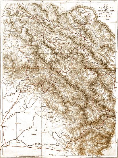
MAP of the MOUNTAINS OF NORTHERN INDIA. to illustrate Dr. Thomson's Travels in Western Himalaya and Tibet.
Dr. Thomson's Route is coloured Red.
Drawn & Engraved by John Arrowsmith.
View larger image
(2.4 MB)
WESTERN HIMALAYA AND TIBET.
CHAPTER I.
Appointment to a Mission about to proceed to Tibet—Leave Firozpur for Simla—Approach to the Mountains—Appearance of Himalaya from Plains of India—Kalka—Ascent to Kussowlee—Vegetation of Plainward Face—Origin of Kussowlee Ridge—Climate and Vegetation of Kussowlee—Aspect of inner ranges—Road from Kussowlee to Simla—Sabathu—Cross Gambar River—Haripur—Tropical Vegetation of Basin of Gambar—Steep Ascent to Simla—its extent and situation—its Vegetation—Oak-forest—Pines—Flora of Spring Months—of Rainy Season—View from Peak of Jako—Structure of Mountain Ranges.
In the month of May, 1847, while with my Regiment at Firozpur on the south bank of the Sutlej, I received intimation that Lord Hardinge, at that time Governor-General of India, had appointed me a member of a mission which he had determined to despatch across the Himalaya Mountains into Tibet; and I was directed to proceed without delay to Simla, from which place the mission was to start, as soon as the necessary arrangements could be completed.
I left Firozpur on the evening of the 20th of May, and travelling only at night, on account of the extreme heat, I arrived at the foot of the hills, on the morning of the 24th. The greater part of the road was through a perfectly level country, and nearly parallel to the Sutlej, but without following its sinuosities. During a part of the last night's journey, I travelled among low hills, partly composed of loose sand and boulders, partly of clay and sandstone. The road enters this tract by an open valley, bounded on both sides by hills, which on the left are low and rounded. On the right they are scarped towards the plains, as well as towards the valley up which I travelled, and the strata of which they are composed, dip towards the Himalaya. The valley is traversed by a little stream descending from the mountains, one of the tributaries of the Gagar or Markanda, that remarkable river, which runs in a south-west direction, as if about to join the Indus, but ultimately loses itself in the sands of the Bikanir desert.
APPEARANCE OF HIMALAYA FROM THE PLAINS OF INDIA. May, 1847.
When viewed from the plains of India, at a distance sufficient to enable the spectator to see the most elevated part of the chain, the Himalaya appear to form several distinct parallel ranges on the horizon, rising in succession one behind another. The most distant of these is covered with perpetual snow, while the other two, usually called the middle and outer ranges, have the usual blue-grey tint of distant mountains. From very great distances in the plains, the most remote of these three apparent ranges is alone visible; and as the traveller advances towards the base of the mountains, the others rise in succession above the horizon.
The optical deception, in consequence of which, masses of mountains of every configuration resolve themselves into ranges perpendicular to the line of sight, as soon as the eye is so far removed that the outline of the different parts becomes indistinct, has given to our maps many mountain-chains, which a nearer inspection proves to have no existence. As a good instance of this, I may mention the Suliman range, west of the Indus, which, though laid down in all our maps as a mountain belt, parallel to and skirting the plain country, behind which no mountains at all are represented, evidently consists of a series of ranges, almost perpendicular to the Indus, and separated from one another by considerable rivers. The sources of these rivers lie far back, and the north and south axis from which they spring, separates all the tributaries of the Indus from a succession of streams, which run in a south-westerly direction, and appear to terminate, without reaching the sea, in the low and flat country of Seistan and western Beluchistan.
At distances of between sixty and thirty miles from the base of the Himalaya, the three parallel chains are well seen. On a nearer approach, the lower and outer mountains by degrees become more distinct, and subtend a greater angle, so as at last to conceal the more distant portions of the chain. At the same time, the uniformity of outline by which they had been characterized, insensibly disappears. Ridges become visible in the face presented to the eye, which, as the traveller continues to advance, become developed into projecting spurs, separated from the general mass by wide valleys, previously quite undistinguishable. On a still nearer approach, the elevation continuing to increase, the extent of range embraced by the eye is gradually lessened, till at last, when we arrive at the base of the mountains, a single valley with its bounding ranges of low hills is alone visible, the giant masses, so conspicuous from a greater distance, being no longer to be seen.
The low sandy or sandstone hills, which form the outskirts of the Himalaya, are not, on the road from Firozpur to Simla, anywhere of greater elevation than a few hundred feet. A few miles beyond the entrance, the valley, which has a considerable slope, widens as it approaches the more lofty mountains, and the sandstone cliffs are replaced by rounded hills, probably of a more ancient rock, covered with soil and vegetation.
KALKA. May, 1847.
At the very base of the steep mountains is situated the village of Kalka, at which, as it is the termination of palankin travelling, travellers in general stop, to arrange for the continuance of their journey. Situated close to the source of the little stream which I had been following since I had entered the hilly country, and surrounded on all sides by low hills, Kalka has an elevation of perhaps 2000 feet above the level of the sea, or 1000 feet above the plain on the outside of the sandstone hills.
The general aspect of the low hills around Kalka is barren and uninviting; it was especially so at the season of my visit, when the great heat had scorched the herbaceous vegetation, and all nature had a burnt-up appearance. The subtropical valleys are not here, as farther to the east along the base of the mountains, filled with dense forest. They are in general bare, a few scattered trees only appearing here and there. In the level part of the valley, at the very entrance, where the soil was still of some depth, Acacia Arabica and Butea frondosa, the most prevailing trees of the plains beyond, were frequent; but the stony water-courses contained little but a bamboo, and the hill-sides were covered with scattered bushes of the more ordinary shrubs of the plains of Northern India, and presented few features of interest.
ASCENT TO KUSSOWLEE. May, 1847.
Immediately on leaving Kalka, a long and steep ascent commenced, continuing for about ten miles, to the military post of Kussowlee, which occupies the crest of the ridge overlooking the Kalka valley, and can be seen throughout the greater part of the ascent, overhanging the winding road, which has been constructed along the side of the mountain. The elevation of Kussowlee is about 6500 feet, an altitude at which the climate in the Himalaya is perfectly temperate, so that during the ascent a traveller from the plains of India meets with a complete change of climate, a change, too, which in the month of May, the period of my visit, is particularly grateful, the heat below being most oppressive and disagreeable.
As the elevation increases, the view from the road becomes more extensive. The low ranges of hills to the south and west, which had obstructed the view, are by degrees overtopped, and the plains beyond become visible. Soon after leaving Kalka the road crosses a low ridge, and enters a receding bay, or steeply sloping valley beyond, at the upper extremity of which, all along the crest, are seen the houses of Kussowlee. Winding round this valley, and continuing to rise, the stream in its centre is crossed about midway, and the ascent continues on the spur which forms its western boundary. This ridge is crossed close to the point where it is given off by the main range, and the road, winding round its most projecting part, enters a fir-wood, and, turning back very abruptly in an opposite direction, proceeds eastward along the northern face of the Kussowlee range.
VEGETATION. May, 1847.
The plainward face of this range, along which the road from Kalka ascends, is quite devoid of forest. The lower part is covered with scattered jungle, to use a most expressive Indian word, of small shrubs, almost all of forms common in the plains. Carissa and Adhatoda are the most common, with Rottlera tinctoria, a plant which does not extend far into the plains, and a scandent leguminous shrub, apparently a species of Mucuna. Around the few houses which occur on the ascent, the bamboo occurs planted, as well as the mango, and other common cultivated trees of the Indian plains. At an elevation of about 4000 feet, an alteration in the vegetation begins to be perceptible. The thin jungle of plain shrubs disappears, the few shrubs which still occur, are generally scattered bushes of Hamiltonia, Nyctanthes, Prinsepia, Scutellaria, and Rubus, but the slopes are usually bare and grassy. Ferns and mosses appear in the crevices of the rocks, and the first individuals of those species which predominate in the temperate zone, are found in shady spots where they are sheltered from the sun. At the same elevation Euphorbia pentagona makes its appearance. This tree, which is confined to the hottest and driest slopes of the Himalaya, is remarkable for its peculiar shape, its thick fleshy five-angled branches, and its milky juice. It is nowhere to be met with in the plains of Upper India, but is common throughout the subtropical belt of the Himalaya from Kamaon westward.
ORIGIN OF KUSSOWLEE RIDGE. May, 1847.
A glance at the map will serve to show that the great Himalayan mountain range, dividing the waters of the Sutlej from those of the Jumna, holds a nearly due east and west course in its middle part, but that at its western extremity it bends round to the south, and terminates in the Indian plain, not far from the town of Nahan, and that (among many others) the Kussowlee ridge is a branch from it, running in a north-westerly direction, and separating the waters of the more western branch of the Gambar, from the small tributaries of the Gagar, which find their way to the plains on the left hand.
The ridge upon which the station of Kussowlee is built, nowhere attains an elevation exceeding 7000 feet. It is very narrow, and often rocky and precipitous immediately below the crest on the plainward face, which dips very suddenly. The inner slope is somewhat less abrupt, and is covered from the summit to perhaps 1000 feet below it, with an open forest of a species of fir (Pinus longifolia), which, in general appearance and mode of growth, much resembles the Scotch fir, but is distinguished by the very great length of its leaves. The barracks for the troops and the houses of the residents are scattered over the northern slope, or perched on the narrow summit of the ridge.
The shrubby and herbaceous vegetation which occurs scattered among the fir-wood, is so markedly different from that which prevails at the base of the mountains, and during the greater part of the ascent, that the traveller appears suddenly transported into a new world. Instead of those tribes of the vegetable kingdom which abound in the torrid zone, all the forms which now meet the eye are characteristic of a temperate climate. The moderate elevation of the range, and its proximity to the plains, tend to lessen the rapidity of the diminution of temperature; and as the greater part of the ascent lies on a bare sunny slope, the tropical flora extends towards the summit, much farther than it does on ranges which rise higher, and are clothed with shady forest. During the ascent, therefore, the traveller, though often struck with the appearance of new forms, is still accompanied by many species familiar to him as natives of tropical jungles, but on passing to the northern face of the spur, the temperate region is at once entered, and most of the tropical forms disappear.
VIEW FROM KUSSOWLEE. May, 1847.
As soon as the crest of the first slope of the Himalaya has been gained, the eye is naturally directed towards the mountains beyond, in order to ascertain their appearance and position, when viewed at a diminished distance and from so much more considerable an elevation than had previously been the case. Nor will the view from Kussowlee in favourable weather disappoint the traveller who is desirous of meeting with beautiful scenery. Immediately to the north lies a deep ravine, and beyond a single ridge is the wide valley of the Gambar, with numerous mountain spurs, which, from their comparatively lower level, are not prominently brought into view. To the south-east the main range dips abruptly to a level, nearly 1000 feet below what it attains in the station of Kussowlee itself, but again rises into the finely wooded hill on which has recently been built the Lawrence Asylum. Still further to the south are deep dells, with bare and rugged slaty mountains, scarcely at all wooded. In the months of May and June, when the atmosphere is generally extremely hazy, the prospect is limited to the ranges more immediately in the vicinity; but occasionally even in these months, as well as in the dry intervals of the rainy season, and during the delightful autumn weather which follows the termination of the rains, a much more distant prospect is opened, stretching far up the valley of the Sutlej, to the snow-clad peaks which, on either hand, hem in that river.
In the direction of the plains of India, the view is also very remarkable. The Kussowlee ridge so completely overtops the hills which intervene between it and the level country, that from its summit they interfere very little with the commanding view of the interminable flat which, like the ocean, stretches as far as vision extends. In the usual state of the atmosphere, especially in the hot season, a dense haze overhangs the plains, and entirely obscures their more distant parts; but in the cold season, as well as at day-break in summer, and especially after heavy rains, the misty vapours are entirely dissipated, and distant objects are defined with extreme precision.
Perhaps the most striking, because the most unexpected part of the view of the inner Himalaya, from Kussowlee, lies in the great depth of the valleys in the interior, and the distance of the next elevated range, of which the appearance of the mountains from the plains of India affords no indication. The extreme narrowness of the ridge, and the suddenness of the descent on both sides, is also very remarkable, and has, as already remarked, a very sensible effect on the climate, the heat of the lower mass being conveyed upwards, while the small extent of the knife-edge-like ridge, which rises above 6000 feet, exposes a minimum surface to the refrigerating influences of a rarefied atmosphere.
ROAD TO SIMLA. May, 1847.
The distance from Kussowlee to Simla is by the road about thirty miles, though in a direct line the two places are not much more than half that distance apart. The road descends from Kussowlee almost to the level of the plains, crossing the Gambar at an elevation of a little less than 3000 feet, and ascends to Simla by following the ridge which runs parallel to that river on its right bank, the source of the Gambar being immediately below Simla. It would indeed be possible to reach Simla, by following the crest of the ridge, without descending at all into the valley of the river; but for this purpose it would be necessary to follow the Kussowlee ridge so far to the southward, in order to reach its junction with the main range, that the length of the journey would be very much greater than that now followed. The road, therefore, only keeps the ridge for a very short distance, or as far as the "col," or lower part immediately north of Kussowlee, which is quite bare of trees. It then turns abruptly to the left, descending on the north face of a spur, at first in a winding manner, afterwards for a short distance along a shady ravine, and finally through a good deal of cultivation, at an elevation of between 4000 and 5000 feet, to a considerable stream which runs towards the north to join the Gambar. The greatest part of the descent is bare of trees, except along the banks of the little stream, which are covered with a belt of wood. The cultivated lands are extensive, occupying a flattish terraced slope, such as is of very general occurrence in the mountains, the fields being adapted for the growth of rain crops, principally of rice, with a few fields of ginger and cardamoms.
SABATHU. May, 1847.
After reaching the stream just mentioned, which is crossed by a ford, a suspension bridge, for which the piers are partly built, having never been erected, the road continues to descend parallel to it towards the north, passing under the military station of Sabathu, which, at the elevation of 4200 feet, occupies the crest of the ridge immediately to the east of the little river, a very short distance before its junction with the Gambar.
After passing Sabathu the road turns to the right, round the projecting ridge of the range, and descends rapidly to the valley of the Gambar river, which is crossed by a good suspension bridge at an elevation of 2700 feet above the level of the sea. It then ascends by a steep and laborious path to Haripur, a small village about 500 feet above the bed of the river. The Gambar river, where the road crosses it, flows through a narrow rocky ravine, somewhat picturesque, but quite devoid of trees. This, however, is not the general character of the river-bed, which is frequently wide, with a broad gravelly channel, and sloping though often rather steep mountains on either side. There is occasionally even a strip of flat land, capable of cultivation along the banks; and where such is the case, the water of the river is carried off in artificial channels, for the purpose of irrigation.
After attaining the crest of the ridge, and passing through the village of Haripur, the road follows the ridge parallel to the river Gambar, nearly all the way to Simla, not always on the very crest or top, which would entail a great many unnecessary ascents and descents, but generally a little on one side or other of the hill, as circumstances may render most convenient; at one time ascending rather steeply, but more generally rather gently as far as Sairi, the last stage on the way to Simla, beyond which the road is pretty level, nearly to the bottom of the mountain on which Simla stands.
The valley of the river Gambar may be regarded as an excellent specimen of a smaller Himalayan river, draining a large extent of country, and discharging its waters independently into the plains, though not, like the first-class rivers, deriving its origin from the snowy mountains. The southern border of the basin of the Gambar, is of course the main chain of the South Sutlej Himalaya; and the whole of the country between the Jutog spur, which leaves that chain at Simla, and the Kussowlee ridge, the origin of which I have already detailed, is drained by the Gambar and its tributaries. This includes an extent of country of not less than 1000 square miles, the bounding ranges of which have, throughout the greater part of their extent, an elevation varying from 8000 to about 6000 feet. Both the Kussowlee and Jutog ranges dip at last rather abruptly, so that it is only during a very short distance that they are below the last-mentioned elevation. This elevation, which is quite temperate, is however by no means that of the whole superficies of the basin, the bed of the river having, at its débouchure into the Sutlej, an elevation of not more than 2000 feet, and rising very gently till near its source immediately below Simla. The lateral ridges, which traverse the basin in every direction, are in general less elevated; not exceeding 5000 feet in their upper part, and sinking to 3000 or even lower, so that the mean elevation of the whole basin cannot be estimated, I should think, higher than 3500 feet.
BASIN OF GAMBAR VEGETATION. May, 1847.
Such being the case, it is not surprising that the general appearance of the vegetation should be tropical, and closely approximate to that of the low hills on the very exterior of the Himalaya. This is in general the case. The hills, which are generally grassy, and, though steep and frequently stony, rarely rocky or precipitous, are quite devoid of forest, or even brushwood, except in a few shady nooks with a northern exposure, and favourably situated with respect to moisture; the shrubby vegetation being thin and scattered. This total want of forest, is unquestionably caused by the dryness of the climate during the greater part of the year, which is to a certain degree increased beyond what it would otherwise be, by the proximity of the surrounding mountain ranges, to which a large proportion of the rain-clouds are no doubt attracted.
In the shady ravines north of Kussowlee, where there is the greatest approach to forest, a species of laurel is the most conspicuous tree. On the more exposed hills, Falconeria insignis and Euphorbia pentagona occur, scattered as small trees, and one small wood of Ægle marmelos is passed close to the village of Haripur. The most common shrubs are Adhatoda Vasica, Carissa, and Zizyphus Jujuba, species universal in the plains of upper India; Colebrookea oppositifolia, Grislea, Bergera, Roylea and Bœhmeria nivea, all species which are throughout the north-west Himalaya, characteristic of the lower and drier parts of the outer ranges. Two Labiate shrubs, Plectranthus rugosus and Meriandra strobilifera, are particularly abundant on the slopes between Haripur and Sairi, and strongly mark the aridity of the climate.
The herbaceous vegetation, being principally of annual growth, approaches still more closely to the plains types. At the season of my journey in May, the extreme drought had dried up almost all the smaller plants, but during, and immediately after the rainy season the herbage is very luxuriant. The steep slopes are then covered with a uniform herbage of tall grasses, which is in many places cut and preserved for hay, by the inhabitants of the scattered villages in the valleys. The most prevailing grasses are a tall sweet-scented Cymbopogon and Heteropogon contortus. A species of Kalanchoë, a large and conspicuous plant, with thick fleshy leaves, is very common, and the superb Gloriosa or Methonica is by no means rare.
On the highest ridges in the valley, at elevations of 5000 feet and upwards, there are frequent approaches to the temperate flora, the shady slopes on northern exposures being frequently covered with small patches of brushwood, containing species of Berberis, Rubus, Spiræa, etc., and numerous herbaceous species, of forms common at Simla. These, however, are quite exceptional, though no doubt with a very little more humidity the shrubby vegetation would rapidly extend, and under its shelter many small plants would be able to grow, which are now, when they attempt to vegetate, destroyed by the scorching heat of the sun.
It must also not be forgotten, that notwithstanding the general tendency to a tropical flora, the natural result of the low elevation and great aridity of these hills, a portion of the vegetation even at the lowest levels consists of plants of European forms, such as characterize the temperate vegetation of the Himalaya. I do not here refer to what may be called the cold-weather vegetation of the plains of north-western India, at which season, the temperature of the air approaching to that of the summer of the temperate zone, a considerable number of European plants make their appearance in corn-fields and along the banks of water-courses; as, for example, Veronica Anagallis and agrestis, Anagallis, Medicago, Melilotus, Potentilla supina, Juncus bufonius, Arenaria serpyllifolia, Heliotropium Europæum, and many others. These naturally occur at the same season, in the low valleys among the hills, in similar situations. The circumstance to which I desire to advert, is the occurrence at very low levels among the mountains, during the hot and rainy seasons, of species belonging to genera characteristic of temperate climates, and which therefore are the prevailing forms at considerable elevations on the Himalaya. As instances, I may adduce the occurrence in the valley of the Gambar, at elevations not exceeding 3000 feet, of species of Thalictrum, Fragaria, Rosa, Rubus, Berberis, &c., &c. This remarkable fact has been ascribed by Jacquemont[1] to the obscure influence of the mountains; and as the genera just enumerated never occur in the plains of Upper India, it appears evident that the mountainous nature of the country must be viewed as an essential element in the reasons for their descent. These, with some others which also occur at low levels in the Himalaya, appear to be in all parts of the continent of India those genera of temperate climates, which descend to the lowest altitudes. Some of them were found by Dr. Hooker on Parasnâth, a hill in upper Behar, the elevation of which does not exceed 4000 feet; and they are all natives of moderate elevations on the Nilgherries and in Ceylon, as well as on the Khasya mountains in eastern Bengal.
ASCENT TO SIMLA. May, 1847.
SIMLA. May, 1847.
The ridge which runs from Haripur to Sairi, parallel to the river Gambar, is a branch from the Jutog spur, nearly north of Simla, a ridge which is given off by the main South Sutlej chain in Simla itself, and which runs directly north to the Sutlej river. The road, after following this ridge till within a few miles of Simla, leaves it on the left hand, to descend into a small stony ravine; after crossing which it mounts abruptly a very steep spur, ascending at least 1500 feet to gain the crest of the ridge, and enter Simla at its north-western extremity.
The hill station of Simla, which was originally selected as a sanatarium, or suitable residence for the servants of Government, or other Europeans, whose health had been impaired by disease, or by too long residence in a tropical climate, has of late years, in consequence of the political state of north-western India, and of the increasing number of retired officers, and of gentlemen unconnected with the public service, who have made it their residence, become a place of great importance. Besides an extensive bazaar or collection of shops, which may now almost be designated a small native town, Simla contains nearly 400 houses, scattered along the crest of different mountain ranges. Its situation is a most favourable one, on the main range of mountains south of the Sutlej river, at a point where a massive peak rises to a height of 8100 feet, and on the nearest part of the ridge to the plains of India, which is sufficiently elevated, well wooded, and situated favourably with regard to water. The greater part of the station is built on the main range, partly surrounding the peak of Jako, and partly on the ridge running north from it, at an elevation of about 7000 feet, as far as a smaller culminating point of the range, which is by the inhabitants named Prospect Point. At this point the main range turns sharply to the west, and the station is continued for nearly a mile on a spur which runs towards the north, passing through the station of Jutog. From the scattered position of the houses, the extent of Simla is much more considerable than the bare statement of the number of houses might lead one to suppose. The northern ridge extends almost four miles, and the circuit of Jako, by the principal road, which is from 500 to 1000 feet below the summit, measures five miles.
In consequence of the sudden elevation of the mountain range at the place where Simla has been built, there is a most complete and surprising change in the vegetation and general appearance of the scenery. During the last ascent on the road from the plains this is sufficiently perceptible, although from the great ravages which the proximity of so large a population has made in the oak woods, only a few stunted bushes are now left on the southern exposure. Between the plains and Simla the hills are totally devoid of trees, but immediately on gaining the top of the ridge on which the station is built, we enter a fine forest, which covers all the broader parts of the range, especially the slopes which have a northern aspect, stretching down on these in many places to the bottom of the valleys, fully 2000 feet.
OAK FOREST. May, 1847.
PINES OF SIMLA. May, 1847.
The nature of the forest varies a good deal with the exposure and with the quality of the soil. By far the greater part consists of an oak and a rhododendron, both small evergreen trees, rarely exceeding thirty or forty feet, with wide-spreading arms and rugged twisted branches. A species of Andromeda is also very common, and a holly, an Euonymus, Rhamnus, and Benthamia, are the other more common trees, if we except the Coniferæ, of which four species occur. Of these, Pinus longifolia is common at the western or lower extremity of the station, and prevails, to the exclusion of any other tree, on the dry sunny spurs which run towards the south, at elevations from 7000 to 5000 feet. This species is, of all the Indian pines known to me (except its near ally P. Khasyana), that which is capable of enduring the most heat, and at the same time the greatest variation in amount of moisture; as it is found at elevations of not more than 1000 feet above the level of the sea, equally in the hot humid valleys of Sikkim, where it enjoys a perpetual vapour-bath, and on the dry sandstone hills of the upper Punjab, on which rain hardly ever falls. It is only, however, at low elevations, where the mean temperature is high, that it is capable of supporting a great amount of humidity, for in the damp climates of the Himalaya it is entirely wanting, except in the deepest valleys; and even in the drier districts it is always observed to select the sunnier, and therefore warmer exposures. Its upper limit is usually about 7000 feet above the level of the sea, though on Jako at Simla a few stunted trees rise as high as 7700 feet.
Pinus excelsa is also a very common species at Simla, particularly on the southern face of Mount Jako, which is the highest part of the ridge. Abies Smithiana, the third coniferous tree, is exceedingly rare, a few trees only occurring in a shady ravine facing the west; while the deodar, the fourth species, is common on the southern and western slopes of Jako, above 7000 feet; and again in shady groves at the bottom of the valleys on both sides of the ridge, as low as 5000 feet. This beautiful tree, the cedar of the Indian mountains, seems limited to the western half of the Himalayan range, extending from the most westerly part of Nipal, as far as the mountains of Affghanistan. It was first described by Roxburgh from specimens sent to him from Kamaon, at a time when the western Himalaya was almost inaccessible to Europeans, under the name by which it is known to the inhabitants of that province, as well as in Kashmir. It is, however, singularly enough, not known by that name in the Simla hills, where it is called Kélu; another conifer, Cupressus torulosa, a rare tree in the district, having usurped the name, as well as the sacred character, of deodar.
In the thick woods of Simla, a large white monkey, the Langúr of the natives, is very common. These animals move about in large flocks, in which may be seen individuals of all sizes and ages, and seldom remain more than a few hours in one place. They are in constant motion, leaping from bough to bough and from tree to tree, chattering constantly; and, notwithstanding their great size, are in general harmless, though ready enough to defend themselves if assailed.
The forest extends in parts close up to the peak of Jako, which has an elevation of 8130 feet. The very summit, however, which is a short flat ridge, and a considerable part of the east and south face, are bare and grassy, or covered with scattered shrubs. The more common shrubby forms of the vegetation of the temperate zone, are Salix, Rosa, Rubus, Lonicera, Viburnum, Berberis, Indigofera, and Prinsepia, all, except the two last, quite European. Indigofera forms a remarkable exception, and one well worthy of note, as the genus is a very tropical one, although its shrubby species are particularly abundant throughout the whole of the western Himalaya. These shrubby species, however, constitute a particular section of the genus, very distinct in habit, and in the large size and bright colour of the flower, from the more ordinary forms, and they are confined to the drier parts of the mountains, being quite wanting in the humid climate of Darjeeling and Khasya, and almost entirely so in the mountains of the Peninsula.
VEGETATION OF THE SPRING MONTHS. May, 1847.
The herbaceous vegetation of the spring months quite corresponds, in the temperate nature of its forms, with what has been found to be the case with the trees and shrubs; but during the rainy season, as has been well pointed out by Dr. Royle in his valuable essay on the distribution of Himalayan plants, this is much less markedly the case. At the commencement of spring, in April (for March is still too cold for much vegetation), the weather being generally bright, though with occasional heavy showers, the earliest flowers are species of Viola, Fragaria, Geranium, Veronica, Valeriana, and dandelion. From April, as summer advances, the temperature gradually rises, till towards the end of June, when the rainy season commences. These months are generally dry, and if no rain falls the heat is sometimes considerable, the thermometer rising as high as 80° in the shade. Still the flora is almost entirely temperate, the early spring plants being succeeded by many others of European families, principally Ranunculaceæ, Rosaceæ, Labiatæ, Stellatæ, Polygonaceæ, Epilobiaceæ, Primulaceæ, etc. I can scarcely enumerate a single spring flowering plant which does not belong to an European family, unless Arum be an exception, which it can hardly be considered, the flowers only being displayed during May and June, while the leaves do not make their appearance until after the rainy season has commenced. Few species are, however, identical with those of Europe, except Stellaria media, Cerastium vulgatum, Taraxacum officinale, Verbascum Thapsus, Thymus Serpyllum, and Poa annua.
FLORA OF RAINY SEASON. July, 1847.
PEAK OF JAKO. July, 1847.
The rainy season generally commences about the 20th of June, or between that date and the end of the month, and continues till the middle or end of September, with occasional intermissions, rarely exceeding a week at a time. During the rains the atmosphere is exceedingly moist, dense fogs usually prevailing when rain does not fall. The rain-fall is probably more considerable at Simla than in the lower ranges, which are nearer the plains, for it has been observed that ranges of 7-8000 feet (which are generally for this reason well wooded), attract much moisture, and the peak of Jako and other parts of Simla are frequently observed from the stations of Sabathu and Kussowlee, to be covered with dense clouds or mist, at times when at the latter places the weather is bright and clear.
The commencement of the rainy season is the signal in the mountains, as it is very universally throughout India, wherever that season is well marked, for the appearance of a very vigorous and luxuriant growth of plants of annual growth, the seeds (or rootstocks) of which had been lying dormant in the soil awaiting the access of heavy rain. At Simla, as elsewhere in the temperate region of the Himalaya, we find at this season numerous species of Balsams, Acanthaceæ, Orchideæ, and Labiatæ, several Gentians and Cichoraceæ, a great many grasses and Cyperaceæ, and species of Parnassia, Drosera, Pedicularis, Roscoea, Dipsacus, Thalictrum, Urtica, etc., etc. Some of these are quite European genera, while others, as Roscoea, are interesting as belonging to orders whose maxima occur in very humid climates. The Labiatæ of the rainy season are mostly species of Plectranthus and Elsholtzia, both quite Indian genera, and very extensively distributed in mountainous districts. Balsams are quite an Indian order, and they seem everywhere, as has already been remarked by Dr. Royle and by Dr. Wight, to abound in humid shady places, either in dense forest or on the stony banks of mountain streams, in the drier districts only during the rainy season, but in more humid countries more or less throughout the year. The Orchideæ of Simla are entirely terrestrial, the dryness and cold of the winter months being greater than are compatible with the occurrence of epiphytical species of this natural order, and for the same reason, I presume, Melastomaceæ, so abundant in the Eastern Himalaya, are quite wanting.
Among the many advantages of situation by which Simla is characterized, one of the most fortunate is its position on a part of the mountain range which lies transversely to the ordinary direction of the chain, so that the view towards the plains of India, as well as up the Sutlej valley, is very much more extensive than would be obtained, had the station been situated in a less favourable position. This advantage is further enhanced by the sudden rise in elevation of the chain, which enables a resident at Simla to overlook in the direction of the plains the continuation of the range which would otherwise obstruct the view. Towards the interior of the mountains, this advantage is not possessed by Simla; for the ridge of Mahasu, which rises 1000 feet higher than the peak of Jako, obscures at least half of the snowy range, the view being limited in that direction to the course of the valley of the Sutlej, and to the mountains north of that river.
VIEW FROM THE PEAK OF JAKO. July, 1847.
With all these advantages of situation, the view from the peak of Jako is one of the most agreeable and diversified, which occur in any part of the Himalaya; although, from the rather too level top of the mountain, and the intrusion of the forest almost to the very summit, the whole panorama cannot be embraced at once. Immediately under the eye are the numerous spurs and ridges covered with scattered houses, and the deep ravines which terminate the steep slopes below the station; towards the plains, the whole valley of the Gambar is seen, with the stations of Sabathu and Kussowlee, the church and esplanade of the former appearing low down almost within a stone's throw, while the brilliant white of the houses of Kussowlee, more nearly on a level with the eye, sparkle in the sunbeams. The ridge of Kussowlee in one place excludes the view of the plains, but to the right they may be seen stretching away in the distance, and only recognizable at last by the track of the Sutlej river, which, from the very remarkable curve close to its exit from the mountains, may be traced as far as vision can extend, a distance of 116 miles[2]. To the north a valley stretches from Simla as far as the Sutlej river, distant about fifteen miles, so direct that the greater part of it is seen, though the river itself is concealed. East of north a long partially wooded ridge, about four miles distant at its nearest point, running parallel to the valley just mentioned, excludes the view of the nearer part of the Sutlej valley; but the lofty ranges north of that river, covered with dense forest, and backed by masses of brilliant snow, close in the view in that direction. Due east lies the Mahasu ridge, covered on the Simla slopes with a dense forest of deodar; and to the south, across the valley of the Giri, towards which numerous rugged ridges run, is the mountain called the Chor, the highest peak of the range which separates the Giri from the Tons, the crest of which is upwards of 12,000 feet in height.
From the peak of Jako, the serpentine course of the range, which prevails universally throughout the Himalaya, may be well traced, as the eye of the spectator, following the direct course of the ridge, can observe numerous turns in its course, each of which, from the great foreshortening, appears much more abrupt than it really is. At each curve the range rises into a peak, while the intermediate portions are lower and excavated into "cols" or passes. In the concavity of each bend of the range is situated the head of a valley, numerous small spurs dividing the different ravines which unite to form it; while on the convex side, from the high portion of the ridge, is given off a branch of the range, forming a separation between two adjacent valleys, each of which occupies a concavity in the main range of mountain.
On my arrival at Simla on the 25th of May, I found that Major A. Cunningham, of the Bengal Engineers, and Captain Henry Strachey, of the 66th Regiment N.I., were to be my fellow-travellers, the former having been appointed the head of the mission. As Captain Strachey had to travel from Dinapore, it was evident that some time would elapse before he would arrive at Simla, nor was it till the beginning of August that the completion of the necessary preliminaries rendered it possible for us to commence our journey. I took advantage of this delay to make myself as far as possible acquainted with the physical features and vegetation of the surrounding country, though the necessary preparations for the approaching journey occupied a good deal of time, and the commencement of the rainy season rendered travelling difficult, and even out-of-door exercise unpleasant. I have already attempted to convey an idea of the general physical aspect of the scenery, which, after a short residence has made one familiar with the structure of the ridges, appears very simple. Situated on the dividing range, by which the waters of the Giri, a tributary of the Jumna, on the left, are separated from those of the tributaries of the Sutlej on the right, the spectator looks into two of the immense basins into which the Himalaya is divided by transverse ranges running parallel to the great rivers; and after a short time he finds that the chaos of mountains, which at first perplexed the eye and confused the mind, gradually resolves itself into a definite shape, each ridge being capable of being referred to its parent, and that in its turn to a branch of the main chain. From his commanding position he can also see that the main range is generally more elevated than its branches, and that each chain, by a succession of sudden sinkings, diminishes in elevation, each peak being lower than its predecessor. Nowhere in the wide tract of country visible is there the least approach to a system of parallel ridges, such as is indicated by the distant view of these mountains. On the contrary, it is seen that the great ranges are, though very irregularly, perpendicular to the general direction of the mountain mass, and that it is only the shorter spurs which have a general uniformity of direction.
STRUCTURE OF THE MOUNTAIN RANGES. July, 1847.
Nor could I find in the structure of the mountains around Simla any confirmation of the view entertained by Humboldt of the sudden elevation of the Himalaya out of a vast fissure in the external crust of the earth. However plausible such a view might appear when the Himalaya is contemplated as a whole (on a map), without any portion of its extent being under the eye, I found it, on the spot, quite impossible to conceive in what way, after such a sudden elevation, any power in the least analogous to existing forces could have excavated out of the solid rock those numerous valleys, so various in direction, so rugged in outline, and so vast in dimensions, which now furrow the mountain mass.
On the contrary, the conclusion has been forced upon me that these mountains have emerged extremely gradually from an ocean, of the existence of which, at very various levels, the most evident traces are, I think, discoverable. The present configuration of the surface must, I do not doubt, have been given to it during periods of rest, or of very slow elevation, the action of the sea upon submerged rocks being so very superficial that no denudation takes place at any great depth. During the period of emergence of the Himalaya, from the great length of the present valleys, which extend between parallel ranges far into the interior, the coast must have borne a strong resemblance to that of Norway at the present day, numerous promontories projecting far into the sea, and separated from one another by narrow and deep bays.
GEOLOGY.
The geological structure of the Himalaya between Simla and the plains is not easily discovered by the cursory observer. The general basis of the mountains is clay-slate, occasionally very micaceous, passing into a coarse sandstone, but here and there limestone occurs interstratified. The dip is extremely variable, and the rocks, whatever their age, are evidently highly metamorphosed. The tertiary formations, so well illustrated by Falconer and Cautley, extend all along the base of the mountains, and penetrate in some places far into the valleys, for certain rocks in the neighbourhood of Sabathu have been indicated by Major Vicary, which appear to be of the same age, or perhaps of a still older tertiary epoch.
CHAPTER II.
Leave Simla—Mahasu Ridge—Pine Forest—Summit of Mahasu—Vegetation of Northern Slope—Fagu—Theog—Mattiana—Cultivated Valley—Nagkanda—Ascent of Hattu—Forest of Pine and Oak—Vegetation of Summit—View from top of Mountain—Plainward slopes bare of forest, while those facing the interior are well wooded—Cultivation at 9500 feet—Descent from Nagkanda towards Sutlej—Damp shady Ravine densely wooded—Kotgarh—Cultivation—Rapid Descent—Change of Climate—Tropical Vegetation—Rampur—Swing-bridge—Diurnal fluctuations in level of River—Gaora—Serahan—Tranda—Western boundary of Kunawar.
On the 2nd of August, 1847, every necessary preparation having been completed, and the officers of the mission having received the instructions of the Governor-General to proceed to Ladakh, and thence to take severally such direction as they should consider most conducive to the increase of our knowledge of these countries, Major Cunningham, Captain Strachey, and myself left Simla.
DEPARTURE FROM SIMLA. August, 1847.
The route selected as most eligible, in order to reach Hangarang and Piti, to which we had been instructed in the first place to proceed, lay up the course of the Sutlej river, through Kunawar. The advanced period of the season, at which almost constant rain might be expected, rendered the river route, on which at most stages tolerable shelter is obtainable, preferable to that by the Pabar valley, and the Bruang (or Borendo) pass, which otherwise we should have preferred, from its passing through a more elevated tract of country.
From Simla the first day's journey towards the interior of the mountains is usually to Fagu, a distance of fourteen miles. Here, and for several stages farther, as far as the road lies through British territory, there are houses (bungalows, as they are termed in India) provided by Government for the accommodation of travellers, upon the payment of a small fixed sum per diem. Though often in bad repair, and therefore very uncomfortable in rainy weather, these houses (which occur also between Simla and the plains) are a very great convenience, as they enable tourists to dispense with the carriage of tents.
The difficulty of making a start, from the small number of porters procurable for our baggage, was so great that it was some time after dark before I reached the Fagu bungalow, in the midst of an extremely heavy fall of rain, which had commenced about sunset, after a fair though lowering day. The road from Simla to Fagu follows throughout the course of the main range, not always on the very crest of the ridge, but seldom at any great distance from it. After passing round the peak of Jako, it turns northward, and descends abruptly about 500 feet, to a low part of the ridge, elevated about 6800 feet, and quite bare of trees, the micaceous slaty rock being in many places exposed. The ridge continues in a direction for nearly four miles, varying very little in level, only one short and rather steep ascent occurring to a peak where a spur branches off to the south, beyond which the road again slightly descends. About half-a-mile to the north of this little ridge, on the slope of the hill below the road, there is a small cluster of trees of Cupressus torulosa, a species of cypress, one of the rarer conifers of the Himalaya; the most favourite situation of which seems to be on very steep mountains in the interior, at elevations of from seven to nine thousand feet. It was found abundantly by Major Madden[3] on Shali, a peak twenty miles east of Simla, and it appears to extend thence west as far as Simla, where it occurs in several places on hot, dry, and very bare rocky hills, as low as six thousand feet.
About four miles from Simla, a sudden increase in the elevation of the range takes place, and at the same time it turns abruptly towards the south-east. The road ascends the steep face of the ridge, in a series of zigzags, rather steeply, with a deep ravine on either hand, that to the right bare, while on the left there is first a thicket of rose and willow bushes, and further on an oak-wood, of a species (Quercus floribunda of Wallich) different from that common at Simla, and indicative of greater elevation, though here growing with Rhododendron and Andromeda, common Simla trees. When near the top of the ascent, the road bends rapidly to the right, keeping on the south face of the ridge, and passing under but close to a small house, built on the very crest of the ridge, at an elevation of about 8000 feet. Close to this bungalow, which occupies a most excellent site, forest commences, and the road runs for a mile through fine trees of deodar and spruce (Abies Smithiana), generally on the very crest of the ridge, looking down towards the east into a deep and broad valley. Right across this valley, north-east, rises the remarkable peak of Shali, a bold rocky mass sloping gently to the south, while to the north, which seems to overhang the Sutlej valley, it is cut off very abruptly. This highly beautiful mountain, the termination of a northerly spur, given off close to Mattiana, is hardly visible from Simla, its top only being seen from some of the more northerly houses.
MAHASU RIDGE. August, 1847.
From an elevation of about 8000 feet at its north-west end, the Mahasu ridge rises, at first gradually, to at least 9000 feet, and as it is throughout well wooded, the road along it is extremely beautiful. On the earlier part of the ridge, the forest consists chiefly of pine, P. excelsa and Abies Smithiana being abundant, and more especially the deodar, which, on the slope facing the west, may be seen in the greatest profusion, thousands of young trees springing up in dense masses, on the slopes which have been bared by the axe, or still more destructively by the fires of the hill-men.
After about five miles of what, in the Himalaya, may be called tolerably level road, another sudden ascent follows, the road inclining rather to the northern slope of the mountain, and entering a dense forest of large massive pines, intermixed with two species of sycamore, and a fine cherry, which relieve the otherwise too gloomy foliage of the coniferous trees. A magnificent climbing vine, which attaches itself to the tallest trees, rising in light green coils round their trunks, and falling in graceful festoons from the branches high over head, adds much to the elegance of the scene, and renders it, in the expressive words of Griffith, who was familiar with the rich vegetation of the humid forests of the Eastern Himalaya, the only true Himalayan forest of the western mountains.
SUMMIT OF MAHASU. August, 1847.
On this ascent the road rises to about 9000 feet, the crest of the Mahasu ridge being, according to Captain Herbert, 9200 feet. The large size and dense shade of the trees, and the abundance of Abies Smithiana, of the sycamore, and of the gigantic vine, give the forest a totally different appearance from that of Simla, and the undergrowth presents also a considerable amount of novelty; a species of currant, a fine Spiræa, Indigofera atropurpurea, and fine species of Rosa and Rubus, forming thickets under the tall trees. This forest, indeed, from its dense shade, and great humidity, exhibits a much greater contrast to the ordinary temperate vegetation of the Himalaya, than is usually observed below 9000 feet, at which elevation the upper temperate, or subalpine vegetation, begins fairly to predominate over that which is prevalent from 5000 to 9000 feet.
On reaching the summit of the steep ascent, the road again gains the crest of the ridge, which consists of a succession of rounded knolls, covered with grass, and quite bare of trees, the forest rising almost, but not quite, to the top. On the very summit of one of the first of these knolls, is a small wooden shrine or temple, of a form common in the hills; the top of a mountain, or the summit of any very steep ascent, being usually selected as a proper spot for the erection of a sacred building by Indian mountaineers, in whose superstition every hill and grove is tenanted by supernatural beings.
POTATO CULTIVATION. August, 1847.
The steep ascent on the northern shoulder of Mahasu, from 8000 feet, and even lower, to above 9000 feet, is the great seat of the potato cultivation in the neighbourhood of Simla. The steepest slopes seem to be preferred for this purpose, if they have only a sufficiency of soil, which is very light, loose, and stony. The undergrowth of shrubs is cleared away entirely on the spot where potatoes are planted, but the pine forest is only partially thinned, the tall straight trunks allowing of a free circulation of air below, while the thick branches above afford the amount of shade requisite for the crop. The potatoes are planted in rows in May; and, early in June, when the plants have attained a height of a few inches, the soil is earthed up round their stems in low ridges. The rains commence in the latter part of June, and during their continuance nothing is done to the crop, beyond keeping it clear of weeds. The steepness of the slope seems to afford a sufficient drainage to prevent any injury from the great rain-fall and constant humidity. The growth of the plants is exceedingly luxuriant, the foliage being tall and bushy. By the middle of October, or after the close of the rains, the potatoes are dug and ready for market, supplying not only the station of Simla, but being despatched in great quantities to the plains of India, where the potato is only cultivated as a winter crop, and where, therefore, during the cold months, none are otherwise procurable.
On the very summit of the Mahasu ridge, there are a few trees of Quercus semicarpifolia, the alpine oak of the western Himalaya, an European-looking and partially deciduous species, and of Picea Webbiana, or Pindrow, the silver fir of the Indian mountains, a dark sombre-looking pine, abundant in the forests of the interior. These trees may be adopted as the characteristics of the subalpine zone, in every part of which, from 9000 to about 12,000 feet, which is the highest limit of tree vegetation in the Western Himalaya, they abound. On Mahasu they are entirely confined to the crest of the ridge, and form no part of the forest below.
FAGU. August, 1847.
The descent from the top of Mahasu to the Fagu bungalow, is at first abrupt, the road leaving the ridge to enter the forest on the northern face, and winding down, after a few hundred yards of bare stony slope, among dense forest, among which it continues for a couple of miles, rising at last rather steeply to the crest of the ridge at the point where it resumes a northerly direction. Here the bungalow of Fagu has been built, at an elevation of 8200 feet, at the very base of the steep mountain ridge behind, which rises abruptly, to a height of six or seven hundred feet. The bungalow faces the north-east, and commands a most superb view of the snowy range beyond the Sutlej, with occasional glimpses of the Jumno-Gangetic snows on the right hand.
On my arrival at Fagu, in the midst of a pelting fall of rain, I found the bungalow already occupied by my fellow-travellers, and before a bright and comfortable fire I soon forgot the discomfort of my wet ride, which indeed was not to be complained of, as it was only what might fairly have been expected in the middle of the rainy season. The confusion among our baggage, however, was so great, from its arriving irregularly and being set down hurriedly by the drenched porters, anxious to escape as soon as possible to shelter, that it was not without difficulty I procured the necessary change of clothing.
The morning of the 3rd of August was densely foggy, but without rain, and it was unanimously decided that it would be advisable to push on to the next stage, Mattiana, a distance of fifteen miles. Our anticipations of fair weather were unfortunately disappointed, for it began to rain heavily before ten o'clock, and continued to do so with little intermission till nearly two, when it cleared, and the remainder of the day was fine.
GIRI VALLEY. August, 1847.
The whole day's journey lay along the ridge, which scarcely fell below 7500 feet, and nowhere rose above 9000 feet. Fagu is situated immediately above the valley of the river Giri, a large mountain stream, the most western tributary of the Jumna. A road across the Jumnetic valleys to Massuri descends abruptly towards that river, descending more than 5000 feet in little more than five miles, and crossing the river by a bridge at an elevation of 3000 feet. The mountains to the right, which dip into the valley of the Giri, are bare of forest, with a good deal of cultivation in small terraced fields on the steep sunny slopes, while scattered houses, scarcely collected into villages, are seen here and there among the fields. On the left hand, again, the deep valley which runs towards the Sutlej is full of forest, not rising however to the ridge, which is bare, or lined only with scattered jungle of Indigofera, Desmodium, Spiræa, roses, and brambles. It seems to be a constant rule that the depressions of the ridges are bare and open, while the more elevated portions are covered with forest. Probably the cause of this is the greater humidity of the higher slopes, which attract the rain-clouds, while the lower ranges are dry. The currents of air which sweep up the valleys may also in part be the cause of the bareness of the ridges opposite their summits.
THEOG. August, 1847.
At Theog, nearly eight miles from Fagu, there is a fort belonging to a Rana, or hill chieftain, and a small village, with a good many fields. The cultivation at this great elevation, for the fields reach to at least 8000 feet, is principally of barley, which is sown in early spring, and reaped in the beginning or middle of June, according to the season. Beyond Theog the road rises a little, and is covered with brushwood on the left hand, but bare on the right. The highest part of the road is about two miles beyond Theog, and has an elevation of about 9000 feet. The northern face of this hill is prettily wooded with the holly-leaved oak, and covered with numerous large angular boulders, whose origin is rather difficult to explain. After passing this little hill the ridge sweeps round to the left in a semicircle, ascending very gradually and gently to a low ridge, from the crest of which the bungalow of Mattiana comes into sight, at a distance of nearly two miles, the whole of which is a gentle descent. The latter part of the road has a direction nearly due north, and the bungalow is situated in a very commanding position on the top of a little eminence, a quarter of a mile from the village, which occupies the slope of the hill facing the south-east, at a considerably lower level. The hills on both sides of the bungalow, which has an elevation of 8200 feet, are extremely steep, and descend at least 2000 feet. The valley on the left, tributary to the Sutlej, is well wooded, but that on the right is rather bare, with only a little wood here and there in the ravines, and on the more shady exposures.
MATTIANA. August, 1847.
The slopes below Mattiana are covered with numerous scattered houses and a good deal of cultivation. A little rice is grown during the rains, but the principal crops are barley and some wheat, sown in spring and reaped before the commencement of the rains. The opium poppy, also a spring crop, is cultivated to some extent in the lower part of the valley. It is sown in early spring, and the opium is gathered in June.
On the morning of the 4th of August we resumed our journey, proceeding as far as Nagkanda, about thirteen miles. Nagkanda, like Mattiana and Fagu, lies exactly on the crest of the main range, south of the Sutlej, and it is possible to proceed to it by a footpath along the ridge. The ascent, however, immediately north of Mattiana, where the ridge rises suddenly to nearly 10,000 feet, is so steep, rocky, and difficult, that it is quite impassable for horses, and so nearly for loaded men, that a more easy, though somewhat longer road is always preferred. I have more than once walked from Nagkanda to Mattiana by the upper road, and found it quite easy on foot, and so very beautiful as to be well worth a visit. The ascent from Mattiana is exceedingly steep, and facing nearly due south, very bare, stony, and barren; but when the higher portion of the ridge has been gained, the remainder of the road lies through beautiful forest, with much fine scenery—the earlier part steep and rocky, the remainder nearly level, till the last descent, and generally on the north face of the range.
VALLEY BEFORE MATTIANA. August, 1847.
On our present journey, however, we took the usual road, which descends from Mattiana to the valley immediately on the east, crosses it, and passes over a long spur on its eastern side, into another valley, the head of which is immediately below Nagkanda, to which place the road ascends, at last very steeply. The ravine immediately below Mattiana is crossed at an elevation probably a little above 6000 feet, as the trees of the temperate region, such as the holly-leaved and woolly oak, Andromeda, and Rhododendron, continue to the very bottom of the descent; and Pinus excelsa is common on the eastern slope, a little way above the stream, which descends very abruptly, like all the hill torrents near their sources, along a rocky channel, filled with large boulders. On the banks of the little stream there were a few trees of an Acacia, common in the lower forests, which Mr. Bentham considers a hairy variety of the Albizzia Julibrissin of western Asia. I observed also a Laurel, an Olive, Rhus, and the common Toon (Cedrela Toona), all indicative of the commencement of a subtropical vegetation, which no doubt must be abundant on its banks a very few miles further down. Few of the plants observed in the valley were different from those common around Simla; a species of Caragana, a Leguminous genus abundant in Siberia, and in the interior and more dry parts of the Himalaya, was perhaps the most interesting.
The ascent from the ravine was well wooded in its lower part with oak and pine. A few trees of a very handsome poplar (P. ciliata), a tall widely-branching large-leaved tree, occurred in its lower part, as did also Benthamia fragifera, and a yew, apparently undistinguishable from the common European species. The upper part of the ascent was bare and grassy. The spur is a steep one, descending rapidly from the main range, and the road winding round its shoulder does not ascend beyond 7000 feet, but as soon as it has gained the eastern face continues nearly level, gradually approaching the centre of the valley, and winding along the hill-sides among numerous villages. The slopes are generally bare; here and there in the hollows or recesses along the lateral streamlets there is some very fine forest.
CULTIVATED VALLEY. August, 1847.
The appearance of this valley is considerably different from that of any of those nearer to the plains. The population is considerable, and collected into villages, some of which occupy the lower part of the valley, and are surrounded by a good deal of cultivation and numerous walnut and apricot trees, the latter of which are said, in autumn, frequently to tempt the bears from the forest, to indulge in what to them is a grateful feast. The ripening of the apricot in a valley, among forest, at an elevation of 7000 feet, indicates an undoubted diminution of the rain-fall. Very little change, however, is observable in the wild vegetation till the upper part of the last steep ascent, when a number of species make their appearance which are strangers to the more external ranges. A species of hazel, as a tree, and Lappa, Achillea, Leonurus, Cheiranthus, and Rumex acetosa, as herbaceous plants, may be mentioned as instances, as also a lax-paniculate Polygonum, with elegant panicles of white honey-scented flowers.
NAGKANDA. August, 1847.
Nagkanda bungalow, elevated 9300 feet above the level of the sea, is situated on a depression of the main range, where it has a direction from west to east. The ridge to the west, towards Mattiana, is elevated little more than 10,000 feet, while to the east rises the peak of Hattu to a height of 10,674 feet, by the determination of the trigonometrical survey. Here the range has approached nearer to the Sutlej, now distant only about twelve miles, than at any point since leaving Simla. The valley of the Sutlej being only 3000 feet above the level of the sea, while the mountains directly opposite rise to 12,000 feet, the scenery is of the grandest description. The river itself is nowhere visible, the descent being so abrupt at the bottom that the intervening spurs entirely conceal it.
The northern slope of the ridge on which Nagkanda stands, is occupied by a very deep valley, bounded by two long spurs, which run towards the Sutlej. The whole of this valley is occupied by dense forest, a great part of which is pine, especially on the upper part of the deep receding bay which runs up nearly to the top of Hattu, the sides of which are covered with a dense sombre forest of Picea Webbiana (Pindrow).
ASCENT OF HATTU. August, 1847.
On the 5th of August, a portion of our baggage, which had been left at Fagu two days before, from a deficiency of porters, not having arrived at Nagkanda, it became necessary to halt, in order to give it a chance of reaching us. The day was fortunately fine, and we availed ourselves of the opportunity to ascend Hattu, Captain Strachey taking with him his barometers, to verify their accuracy by the trigonometrically determined height of this mountain, which was one of the stations of the Himalayan survey by Captain Herbert. As the top of the mountain is only about 1500 feet above the Nagkanda bungalow, and the distance is nearly five miles, the ascent is an easy one. The first mile is nearly level, and bare of wood on the ridge, though the forest on both sides rises within a few feet of the crest, which is bordered by brushwood. As soon as the ascent commences, the ridge becomes covered with forest, at first principally pine, spruce and silver fir (Picea) being the principal species. Yew is also very common, forming a fine tall tree, and the few non-coniferous trees are chiefly the alpine oak, sycamore, and cherry. The road, which at first ascends a western spur, by degrees winds round to the face of the mountain, and finally ascends to the summit from the east. The wood on the upper part is entirely oak, and more open than the pine forest lower down. The top of the mountain is steep and bare towards the east, for about five hundred feet, with precipitous rocks thirty or forty feet high towards the west, below which the slope is exceedingly steep and rocky in that direction.
The continuation of the main range towards the east is at first lower than the peak of Hattu some 600 or 700 feet, but rises again to another peak within a mile. A long spur or ridge to the south-west is, however, for nearly two miles, within a few feet of the same height as the summit of Hattu, and rises at about that distance into a point, which probably rather exceeds it. It then sinks rapidly towards the Giri river, the most easterly branch of which has its source in the ravine on the eastern face.
TOP OF HATTU. August, 1847.
On the top of Hattu there are the remains of a square building, with very thick walls, I believe of native origin, and intended as a sort of fort, which, however, from the want of water, must have been quite untenable. It is now in ruins, its interior being filled with a wilderness of hemp, nettles, Galium Aparine, dock and other coarse plants. The grassy slopes of the summit are covered with a luxuriant herbage of Potentillæ, Labiatæ, Gentianaceæ, Epilobium, Polygonum, and Anemone, while a few stunted bushes of Quercus semicarpifolia, a simple-leaved Pyrus, and a willow, are the only shrubby vegetation. The forest, however, rises close to the base of the cliffs on the western face, and contains all the species common on the ascent of the mountain, the vegetation of the summit being in no respect peculiar, not even in early spring exhibiting any truly alpine plant. The mountain bamboo, a graceful small species of Arundinaria, which is extremely abundant in the woods of the upper temperate and subalpine zones, adorns the rocky hollows close to the summit.
VIEW FROM HATTU. August, 1847.
In every direction except south, and along the ridge to the east, the view from the top of Hattu is very extensive, as it overlooks all the peaks in the immediate vicinity. To the north the mountains of Kulu, which separate the valley of the Sutlej from that of the Beas, and from the upper Chenab, are most beautifully seen, their peaks rising above one another from west to east, till they enter the region of perpetual snow. Towards the plains, in clear weather, the view must be superb; but in that direction there is so generally a hazy state of the atmosphere, that though I have ascended Hattu four times, I have never been fortunate enough to obtain a favourable day.
In looking back from the summit of Hattu towards Simla and the plains, it may be observed that the country is well wooded, though when viewed from Simla or the heights of Mahasu the same mountains had appeared almost bare. This diversity in the aspect of the country, according to the direction from which it is seen, is due to the ridges being well wooded on one face, and bare of trees on the other. The plainward face is never, except under very exceptional circumstances, at all wooded, while the northern and eastern slopes are generally covered with forest. Probably the more direct influence of the sun, and the action of the strong winds which generally blow up the valleys towards the interior of the mountains, act in concurrence in drying the atmosphere, and checking the growth of trees on the southern and western faces of the ridges.
The shrubby and herbaceous vegetation of Hattu is exceedingly luxuriant. The more open glades of the forest are filled with an undergrowth of tall balsams, annual-stemmed Acanthaceæ, Dipsacus, Compositæ (among which the beautiful Calimeris is very abundant), while in the drier pine-forest a graceful little bamboo occurs, often to the exclusion of every other plant. It grows in dense tufts, eight or ten or even twelve feet high, the diameter of the stem not exceeding a quarter of an inch. The currant of the Mahasu ridge is also common, with many of the same shrubs which are there abundant. The ridge close to Nagkanda is much drier, and has fewer peculiar plants; the resemblance to the Simla flora being there very remarkable.
CULTIVATION. August, 1847.
On the southern slopes of this ridge, at elevations equal to that of Nagkanda bungalow, and even higher, in some places as high as 9500 feet, there are considerable patches of cultivation. Barley is probably the spring crop, but during the rains a good deal of buckwheat is cultivated. This plant will not thrive in the very humid regions, and is therefore indicative of a drier climate than that of Simla; indeed, even the occurrence of cultivation at such an elevation, during the rainy season, satisfactorily proves the existence of a more moderate rain-fall and greater warmth than on the peaks nearer the plains, as for instance on the Mahasu ridge, on which, except the potato, no cultivation whatever is attempted during the rains, though there are a few fields of wheat or barley in one spot as high as 8000 feet.
DESCENT TOWARDS THE SUTLEJ. August, 1847.
SHADY RAVINE. August, 1847.
Our missing loads having arrived at Nagkanda on the evening of the 5th of August, we resumed our journey on the morning of the 6th, marching to Kotgarh, ten miles. At Nagkanda we finally left the main range, and began to descend towards the valley of the Sutlej, following, at the commencement of our journey, a spur which runs from immediately west of the bungalow directly towards the river. After about four miles we quitted this spur to descend into the valley on the right, after crossing which we ascended to Kotgarh, situated on a long spur descending from the peak of Hattu. The early part of the descent was very abrupt, through a forest of large pines, principally P. excelsa and spruce (Abies Smithiana). Some trees of the latter measured upwards of seventeen feet in circumference. Sycamore and cherry were also common in the forest, and a good many trees of Corylus lacera, the hazel of the north-west Himalaya, were observed. The trees were festooned with the gigantic vine already noticed in the Mahasu forest. After the first two hundred feet of descent, the forest was less dense, and chiefly pine. Rhododendron arboreum commenced about 1000 feet below Nagkanda, and was soon followed by the holly-leaved oak, and a little lower by Q. incana, the common hoary oak of Simla; and by the time we had got down to 7000 feet, the vegetation was quite similar to that of Simla. At a little below this elevation, the road leaves the crest of the ridge, which may be seen to continue in a northerly direction, partly bare and partly pine-clad, and descends rapidly to the bottom of the deep ravine on the right. Soon after leaving the ridge we entered thick forest, and at the bottom of the ravine two considerable streams are crossed within a very short distance of one another, at an elevation of about 5500 feet, the lowest level to which we descended during the day's journey. Along the banks of these streams, which have a considerable inclination of bed, the forest is very dense and shady. Few of the trees are coniferous, nor do oaks in this part of the Himalaya select such moist localities. Lauraceæ of several kinds, the horse-chesnut, alder, and hornbeam (Carpinus viminea), with Toon and Celtis, are the prevailing trees.
The streams which the road here crosses descend from different parts of the ridge of Nagkanda. They occupy the bottom of deep ravines, and are in their whole course densely wooded. These ravines are, in their upper part especially, extremely steep and rocky, often with precipitous walls, and scarcely practicable even on foot. The denseness of the forest is principally due to their northern exposure, and to the consequent more equable temperature and greater humidity. They contain many trees not previously observed on the journey from Simla, though all of them, I believe even the horse-chesnut, occur in the very similar steep rocky ravines below Fagu. The alder is a common tree at 4-5000 feet in the north-western Himalaya, always in valleys and on the banks of streams.
In this shady forest I collected a considerable number of plants which do not occur at Simla. A scandent Hydrangea, the loosely-adhering bark of which separates in long rolls like that of the birch, and is used as a substitute for paper, was seen twining round the trunks of trees. I observed also a fine Calanthe, and abundance of Adenocaulon, a remarkable genus of Compositæ, which, till Mr. Edgeworth discovered a species in the Himalaya, was only known as a native of South America. In the thickest part of the forest in this ravine, I was also fortunate enough to meet with a few specimens of Balanophora, which here probably attains its western limit. All these plants are abundant forms in the most humid parts of Nepal and Sikkim, and their presence may, I think, be regarded as indicative of a more equable temperature throughout the year than prevails in the more open parts of the Sutlej Himalaya. The range of mountains on which Nagkanda stands certainly intercepts a great deal of moisture during the rainy season, and therefore makes the valleys on its northern aspect less humid at that period of the year. This would appear to be more than counterbalanced by the effect of the dense forest in keeping up moisture and preventing radiation during winter, for the cold and dryness of that season seem to have a much greater effect in determining the cessation of the forms characteristic of the eastern Himalaya, than the diminished rain-fall during the three months of the rainy season.
KOTGARH. August, 1847.
After crossing the stream at the bottom of the valley, the road advances in a northerly direction, at first gradually ascending through fine shady woods, but afterwards, turning to the right, mounting rapidly by very abrupt zigzags, up a bare dry hill-side, to the Kotgarh ridge. Here we took up our quarters for the night, in a house the property of Captain P. Gerard, a little above the village of Kotgarh, at an elevation of about 7000 feet, in a fine grove of Pinus excelsa.
Kotgarh, a large village, and the seat of an establishment of missionaries, was at one time a military post, and is interesting to the Himalayan traveller, from the fact of the detachment here stationed having been long commanded by one of the brothers Gerard, whose labours in these mountains, geographical and meteorological, are so well known. It has, however, long been abandoned as a military station, the peaceable state of the hill population rendering it unnecessary to keep a garrison in these mountains.
CULTIVATION. August, 1847.
Captain Gerard's house, in which we spent the night, is elevated several hundred feet above the upper part of the village of Kotgarh, which occupies the steep face of the ridge directly overlooking the valley of the Sutlej. One reach of the river is visible from the front of the house, and the deep roar of the rapid stream was distinctly audible, notwithstanding that we were still 4000 feet above it. On the morning of the 7th of August we resumed our journey, descending abruptly through the village of Kotgarh to the Sutlej. At first the pine-forest which surrounded our night quarters, accompanied us down the steep hill-side. It was intermixed with a few scattered deodars; and the shrubby and herbaceous vegetation was in all its features identical with that of Simla. Soon, however, the descent was on a bare hill-side, and after reaching the village, the road, inclining to the right or east, kept nearly level for about a mile, passing through much cultivation, in terraced fields on the slopes. The crops were Kodon (Eleusine Coracana) and a cylindrical-headed Panicum, both grains commonly cultivated in the plains of India. There were also many fields of Amaranthus and Chenopodium. The first of these is occasionally cultivated in all parts of the hills, its bright red inflorescence, in autumn, tinging with flame the bare mountain slopes. The Chenopodium was new to me as a cultivated grain, and is particularly interesting from its analogy with the Quinoa of South America. It is entirely a rain crop, and grows very luxuriantly, rising to a height of six or eight feet, with a perfectly straight stout very succulent green stem, and large deltoid leaves, either pale green or of a reddish tinge, and covered with grey mealiness. The seeds, which are extremely small, are produced in great abundance on all the upper part of the plant, and are ripe in September.
DESCENT TO THE SUTLEJ. August, 1847.
For about a mile after leaving the village of Kotgarh, the descent was trifling, but the remainder of the road to the Sutlej was very steep, so that the change in the vegetation was sudden, commencing just at the point where Quercus incana disappeared; before which few plants indicating heat occurred. The want of wood, no doubt, assisted the rapidity of the change, for the heat soon became considerable. In the course of the descent, I noted all the new forms as they occurred; but the exact order in which each individual species makes its appearance, depends so much upon accidental and unimportant circumstances, and is so likely to be affected by errors of observation, unless many series are obtained in different aspects of the same slope, that it would lead to no advantage to enumerate the species as they were met with. Nearly 1000 feet above the bed of the river, or at an elevation of about 4000 feet, the vegetation had become quite subtropical, species of Mollugo, Polanisia, Corchorus, Leucas, Euphorbia, Microrhynchus, and the ordinary grasses and Cyperaceæ of the plains, being the common weeds. The descent continued very abrupt, the heat increasing rapidly, till the road reached the bank of the Sutlej, at the village of Kepu, which occupies a flat piece of land overhanging the river.
VALLEY OF THE SUTLEJ. August, 1847.
Having commenced our day's journey before daybreak, in order to complete the march before the extreme heat had commenced, we stopped here to breakfast, under the shade of a fine mango-tree. The neighbourhood of the village was well cultivated, with extensive rice-fields and a fine grove of tropical trees—mango, Ficus Indica and religiosa, Melia Azedarach and Azadirachta, Grewia, oranges, and plantains. Our late residence in a cool climate made us feel the heat much, though the temperature at nine in the morning was not much more than 80°. After breakfast, we continued our journey up the valley, to Nirt or Nirat, a distance of six or seven miles, and next day we reached Rampur, the capital of Basehir, twelve miles further, and still in the Sutlej valley.
The district of Basehir is an independent hill state, governed by a rajah, whose dominion also extends over Kunawar; it commences a very little north of Kotgarh, and occupies the south side of the river Sutlej and the mountain slopes above it, as far east as the confines of Kunawar. The valley of the Sutlej, in the western part of Basehir, from Rampur downwards, has an elevation of little more than 3000 feet, Rampur (140 feet above the bed of the river) being 3400 feet above the level of the sea[4]. The river, at the season of our journey, which was the height of the rains, at which time it is at its largest, is an impetuous torrent, of great size, but very variable in breadth, foaming along over a stony bed, with generally very precipitous rocky banks, and filled with large boulders. During the rainy season it is extremely muddy, almost milky, and deposits in tranquil parts of its course a considerable amount of white mud. The valley is generally very narrow, with steep bare hills on either side, quite devoid of trees and covered only with a few scattered bushes and long coarse grass. In the bays or recesses on the mountain-sides, between the terminations of the rocky spurs which descend to the river, the valley is often filled with a hard conglomerate rock, the cement of which is calcareous, evidently (geologically) of very recent origin. These patches of conglomerate are flat-topped, and often scarped towards the river, and are frequently 200 feet and more in thickness. They differ in degree of consolidation only from ordinary alluvial deposit, so that they appear to owe their preservation from the denuding effects of river action, to the calcareous matter, which has cemented the pebbles and sand into a solid rock.
VEGETATION. August, 1847.
The road follows throughout the course of the river, rising sometimes 200-300 feet, to pass over rocky spurs; at other times it lies on the surface of the boulder conglomerate, and more rarely close to the river. Here and there is a small village, with a few rice-fields, but the greater part of the valley is utterly sterile. Like the valleys of the outer Himalaya, that of the Sutlej here exhibits a curious mixture of the ordinary vegetation of the plains, with forms which point out the mountainous nature of the country. The whole flora is strongly characteristic of a dry soil and an arid climate. The mountain ranges to the west and south, no doubt, intercept a good deal of rain; and the lofty mountains, 10-12,000 feet in height, which, on the right and left, rise rapidly from the river, appropriate to themselves a great part of the moisture which reaches the valley. We may, therefore, in the absence of direct meteorological observations, infer, from the physical structure of the valley, and from the nature of its vegetation, that its climate is drier than that of the valleys at the base of the Himalaya.
The Sutlej valley cannot, of course, be properly compared with the base of the mountains farther east, where luxuriant forest covers all the slopes; but when contrasted with the Pinjor valley, or the low hills above Kalka, it is only on a careful comparison that a difference is to be observed, and then, perhaps, more by the absence of forms abundant in them than by any marked addition of new ones. The ordinary shrubs of the Sutlej, at 3000 feet, are Adhatoda Vasica, Carissa edulis, Colebrookea, Rottlera tinctoria, and some species of Bœhmeria, all characteristic of the outer hills, and the two first common plains plants. The remarkable Euphorbia pentagona is also common. Butea, Ægle, and Moringa do not occur, nor are there any bamboos. Flacourtia sepiaria, Capparis sepiaria, and Calotropis, which are three of the commonest plants of the plains, were also not observed. A large white-flowered caper (Capparis obovata, Royle) and a glabrous Zizyphus were the most remarkable new forms. The herbaceous vegetation differed scarcely at all from that of the plains, consisting chiefly of species which, during the rainy season, spring up in the lightest and driest soils.
Mountain plants were only occasional, and mostly such as at Simla descend on the dry grassy slopes into the valleys: a berberry and bramble (Rubus flavus), Plectranthus rugosus, which is a grey and dusty-looking shrub, Melissa umbrosa, Micromeria biflora, a little Geranium, Ajuga parviflora, a Galium, Senecio, Aplotaxis candicans, and one or two Umbelliferæ. They did not, however, amount to a twentieth part of the whole vegetation, and the aspect of the flora was quite subtropical. A little Eriophorum, which is everywhere common in arid places at the base of the Himalaya, from Assam to the Indus, was frequent in the crevices of the rocks. Ferns were very scarce, only two or three being observed.
RAMPUR. August, 1847.
The town of Rampur is a considerable place, on a small level tract of ground, about a hundred feet above the bed of the river Sutlej, which it overhangs. The houses are substantially built, in the form of a square, with an open space in the centre; they are mostly one-storied, and have steeply-sloping slated roofs. The town has a good deal of trade with Tibet, principally in shawl wool, and is the seat of a small manufacture of white soft shawl-cloths. The river is here crossed by a rope suspension-bridge, of a kind very common in the lower valleys, which has often been described. It consists of nine stout ropes, which are stretched from one side of the river to the other. The width of the Sutlej at the bridge, according to Captain Gerard, by whom it was measured, is 211 feet.
During our stay at Rampur, Major Cunningham directed my attention to the alteration of the level of the river at different periods of the day, from the variable amount of solar action on the snows by which it is fed. This effect he had noticed on his former visit to the mountains, and we had frequent opportunities of observing it during our journey. At Rampur the diurnal variation was not less than three or four feet, the maximum being, I believe, during the night or early in the morning. In the immediate vicinity of snow, the streams are highest in the afternoon, but as the distance increases the period of greatest height becomes by degrees later and later.