Volcanoes and the Theory of Plate Tectonics
Reading edition
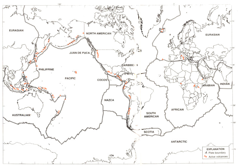
Major tectonic plates of the Earth.
[This map in a higher resolution]
Only a few of the Earth’s active volcanoes are shown. (Sketch by Ellen Lougae.)
PLATES
EURASIAN
NORTH AMERICAN
JUAN DE FUCA
PHILIPPINE
CARIBBEAN
PACIFIC
COCOS
NAZCA
AUSTRALIAN
EURASIAN
ARABIAN
INDIAN
AFRICAN
SOUTH AMERICAN
SCOTIA
ANTARCTIC
EXPLANATION
Plate boundary
Active volcanoes
Volcanoes are not randomly distributed over the Earth’s surface. Most are concentrated on the edges of continents, along island chains, or beneath the sea forming long mountain ranges. More than half of the world’s active 7 volcanoes above sea level encircle the Pacific Ocean to form the circum-Pacific “Ring of Fire.” In the past 25 years, scientists have developed a theory—called plate tectonics—that explains the locations of volcanoes and their relationship to other large-scale geologic features.
According to this theory, the Earth’s surface is made up of a patchwork of about a dozen large 8 plates that move relative to one another at speeds from less than one centimeter to about ten centimeters per year (about the speed at which fingernails grow). These rigid plates, whose average thickness is about 80 kilometers, are spreading apart, sliding past each other, or colliding with each other in slow motion on top of the Earth’s hot, pliable interior. Volcanoes tend to form where plates collide or spread apart, but they can also grow in the middle of a plate, as for example the Hawaiian volcanoes.
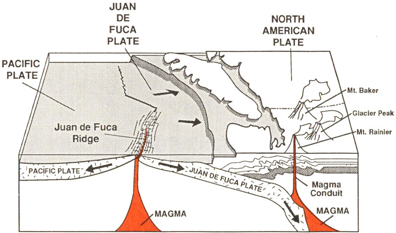
The boundary between the Pacific and Juan de Fuca Plates is marked by a broad submarine mountain chain about 500 km long, known as the Juan de Fuca Ridge. Young volcanoes, lava flows, and hot springs were discovered in a broad valley less than 8 km wide along the crest of the ridge in the 1970’s. The ocean floor is spreading apart and forming new ocean crust along this valley or “rift” as hot magma from the Earth’s interior is injected into the ridge and erupted at its top.
In the Pacific Northwest, the Juan de Fuca Plate plunges beneath the North American Plate. As the denser plate of oceanic crust is forced deep into the Earth’s interior beneath the continental plate, a process known as subduction, it encounters high temperatures and pressures that partially melt solid rock. Some of this newly formed magma rises toward the Earth’s surface to erupt, forming a chain of volcanoes above the subduction zone.
PACIFIC PLATE
Juan de Fuca Ridge
JUAN DE FUCA PLATE
NORTH AMERICAN PLATE
Mt. Baker
Glacier Peak
Mt. Rainier
MAGMA
Magma Conduit
9
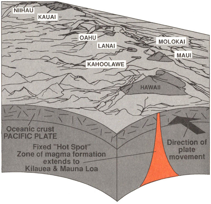
Located in the middle of the Pacific Plate, the volcanoes of the Hawaiian Island chain are among the largest on Earth. The volcanoes stretch 2,500 km across the north Pacific Ocean and become progressively older to the northwest. Formed initially above a relatively stationary “hot spot” in the Earth’s interior, each volcano was rafted away from the hot spot as the Pacific Plate moves northwestward at about 9 cm per year. The island of Hawaii consists of the youngest volcanoes in the chain and is currently located over the hot spot.
HAWAII
NIIHAU
KAUAI
OAHU
MOLOKAI
LANAI
MAUI
KAHOOLAWE
PACIFIC PLATE
Oceanic Crust
Fixed “Hot Spot” Zone of magma formation extends to Kilauea & Mauna Loa
Direction of place movement
10