Chapter IX · WHAT TO SEE
Reading edition
Approaching Sitka by the usual steamer route from the north at a distance of six miles the site of Old Sitka is passed. It lies to the left of the steamer track, in a small bay, and is marked by a native house which is visible from the ship. From near this place, looking to the westward, the first sight of Mount Edgecumbe is to be had between the islands. On approaching the town the ship goes through a narrow channel between Japonski Island at the right and the townsite at the left. Near the middle of the channel a rock is marked by a buoy and along the shore is the native village, or “Ranche,” with a sloping beach upon which in former days the canoes were drawn up. The paths by which they were brought from the water may be seen, marked by the rocks being thrown to each side from the track.
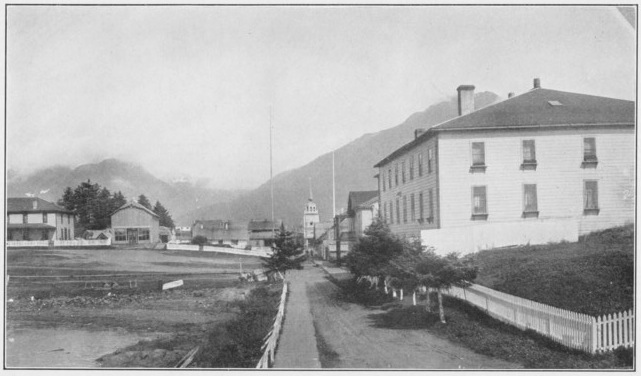
Sitka–East on Lincoln Street–the Governor’s Walk of the Russians.
On Japonski Island is the U. S. Naval Coaling Station and the U. S. wireless telegraph. The magnetic observatory of the Russians was situated there. The name means Japan Island and is given because Resanof designated it as the place to keep captive Japanese whom he expected to capture through his expedition against the lower Kuril Islands in 1806.
The dock at which the ship lands is in the same location as the one used by the Russians, but it has been extended to deeper water. The timbers of the old hulk once used by the Russians as a landing stage may still be seen in the water at low tide. On the dock was the landing warehouse of the Russians, a log structure with a passage through the center. It was burned in 1916. Leaving the wharf and going eastward along Lincoln Street, at the side are the booths or tents of the native merchants, kept by the women from the village, a veritable arcade of little markets, and each of the vendors is as interested as though she occupied a seat on the famous Rialto Bridge to sell the wares of ancient Venice. The picturesque, dark-skinned Thlingit women sit at the doors of their little tents hour after hour, offering the strangely carved totems, the beautiful baskets of spruce roots woven in mystic designs, the beaded moccasins, etc., products of their industry during the long winter when the tourist boats do not call at the Sitka wharves. Passing up the street to the east from the landing–at the right is the U. S. cable office, occupying the site of the old Russian fur warehouse. Next is the three-story building used for courthouse and jail, formerly the Russian Barracks where the Siberian Battalion was quartered. This is one of the most prominent of the old buildings which remain. In front of this is the stairway leading to the top of the hill on which is situated the building of the Agricultural Department, on the site of the former residence of the chief manager of the Russian American Company. Around this hill were the batteries of the Russians, commanding the Kolosh village and the harbor. The former building was often called the Governor’s Mansion, or the Baranof Castle, was built about 1837 and was destroyed by fire in 1894. The hill commands a fine view of the harbor and the surrounding islands. The present structure is the headquarters of the Alaska division of the Agricultural Department. Opposite the stairway to the hill is the way leading to the “Ranche;” the open square was the former parade ground of the Army, and later of the U. S. Marines from the Man-of-War which was stationed here. East of the old barracks building is the former counting house of the Company, now occupied as the U. S. Postoffice, and during the time when Sitka was the Capital of the Territory it was used by the United States for a Customs office, and by the Governor as an office. Going east on Lincoln Street, the next large building at the right was the old bakery and shops of the Company, later commonly known as the Sitka Trading Company Building, having been occupied by that company for many years. Beyond this on the same side of the street at a short distance is a small building, standing back from the walk, surmounted by a Greek cross, which marks the site of the first church built in Sitka, in 1817. Next to this lot is the one formerly occupied by the Lutheran Church, built in the time of Etolin, and in which the first church service was held by Chaplain Rainier of the U. S. Army, after the American occupation.
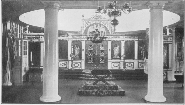
Interior of Cathedral of St. Michael
Across the street is the Cathedral of St. Michael, the headquarters of the Greek Orthodox Church in Alaska. In the Territory are claimed to be ten thousand communicants of that faith and from Sitka the management of affairs is conducted. The church is in the form of a cross and is surmounted by the Greek cross. The interior is richly decorated after the usual custom of the Russian churches. Candlesticks of massive design stand at either side of the doors of the inner sanctuary. The building, with its dome, is distinctive, and is a good example of Russian church architecture.[30]
Continuing east along Lincoln Street a short distance beyond the Cathedral a vacant space on the right marks the spot formerly occupied by the clubhouse, built by Etolin for a home for the clerks, navigators, and other employes of the Company–opposite it was situated the foundry and machine shops, while a little farther to the east stood the sawmills, at the mouth of the outlet to Swan Lake. Along this stream was the eastern boundary of the stockade of the Russian fort, with a blockhouse near the point of the lower end of the lake. East of this stockade were the kitchen gardens, but all traces of them have long since vanished. Continuing along the street following the shore, the Bishop’s house is passed on the left, where the Russian school is taught, and a short distance beyond is the house of the Episcopal Bishop of the diocese, Rev. Bishop P. T. Rowe. Still farther to the east is the Sheldon Jackson School, the Presbyterian Mission School, consisting of a group of buildings, the first of which was completed in 1880, under the superintendence of Rev. Alonzo Austin, and others have been added from time to time until the present fine establishment has resulted. An octagonal structure shelters the Sheldon Jackson Museum, a fine collection of native work of many kinds, gathered from all parts of Alaska by the first superintendent of native schools for the Territory. A small paper is published by the mission, the Verstovian, and is printed by the native students of the institution.
Opposite the mission, at the edge of the curving beach, a large, flat-topped rock lies at the side of the way, called the Blarney Stone. On this it is said that Baranof often sat, during the last year of his residence here, and looked out through the vistas between the islands to the broad Pacific. What were the thoughts of the brave, strong, strange, old man as he sat here will never be known, but it is sure that there was much of sadness for him in those days.
Beyond the Mission is the famous Indian River Road, a continuation of the Governor’s Walk of the Russians, and often called the Lover’s Lane. It winds along the shore of the sea, through the Park, with here and there an opening in the forest where there are splendid examples of Hydah carvings in the tall totems placed in well chosen spots. These totem poles were taken to the St. Louis Fair in 1904, as a part of the Alaska Exhibit, and afterward returned to this park. One of the most interesting is the house totem of Chief Son-i-hat, of Kasaan, accompanied by the four supporting columns of the ancient tribal house.
From the rustic bridge on the Indian River there are enticing paths leading along the stream and toward Mt. Verstovia, which towers above the bay to the height of 3,216 feet. Along the river, known as the Kolosh Ryeka, by the Russians, the winding paths are bordered with huge Sitka spruces and giant cedars, with the space thickly filled with a dense growth of shrubbery, among which is prominent the Devil’s Club (panax horridus), with its beautifully palmated leaves and its cruel spines concealed underneath. This shrub was formerly used by the natives as an instrument of torture in their witchcraft. In the depths of the forest the earth is covered with a carpet of ferns and mosses, and the trunks of fallen trees of former years may be seen with other trees of from two to three feet in diameter growing on their prostrate bodies.
Returning toward the town, at the Mission the Davis Road turns toward the north. It was built by the Army during their occupation, in the process of their securing wood from the forest, and named for General Jeff C. Davis, the Commander of the post. Following it the Military Cemetery is reached at the distance of about three-eighths of a mile. Here are some interesting monuments, among them being that of Gouverneur Morris, a descendent of the famous financier of the Revolution. A stone marks the resting place of a lieutenant of the U. S. Army, around whose memory lingers stories of a duel with a brother officer in a solitary spot along Indian River, over a Russian beauty of Sitka.
Turning aside from Lincoln Street at the Mission, or at the street next westward, a walk of a quarter of a mile leads to the experiment farm of the Agricultural Department of the United States. There may be seen many products, including apples and strawberries of an excellent quality. Of the latter is a variety originated by Prof. Georgeson through hybridizing the cultivated berries with the wild native berry which grows luxuriantly at many places in Alaska.
On reaching the Cathedral a street turns northward along which one finds, at the right, on the little knoll in the town, among the scattered spruce trees, the spot where formerly stood the tea houses of the Russians. They were in the center of the public gardens which covered the knoll and were approached by beautifully bordered walks. Farther along, on the left of the walk, is the remaining Russian blockhouse, the last of three which formerly stood on the line of the stockade that protected the town from the Kolosh. A little back of the blockhouse is the grave of the Princess Maksoutoff, marked with a marble slab lying on the raised mound above her resting place. At the end of the walk is the modern Russian cemetery, with its forest of Greek crosses, and in the center, at the highest point, is a platform from which is had an excellent view of the harbor, islands, Mt. Edgecumbe, and of the lake and town.
Returning as far as the site of the tea gardens, then going westward toward the water, at the right is an enclosure in which there is a small building marking the site of the Koloshian Church, or the Church of the Resurrection, as it is called in the church records. This was the building occupied by the natives in 1855 when they made an attack upon the town. It was on the line of the stockade which formerly ran from the water front at the end of the “Ranche,” east to the lake, then back to the water at the sawmill. On the line of the stockade were three blockhouses, the church being between the first and second of these. Surrounding the site of the church are a number of graves, and among them are some interesting monuments dating back to the Russian days, for this is the older of the two cemeteries.
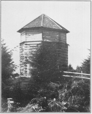
Russian Blockhouse.
Going down to the entrance to the native town, or “Ranche,” there is a choice of two streets, one in front of the houses along the water front, the other at the rear. The one at the front is preferable. The houses are built of lumber and in general are constructed by the native workmen, who have been instructed at the mission school, at which there is an excellent manual training department. The great tribal houses of former days have long since disappeared. The older houses were named by the natives much as were the inns of old England; the Gooch-haet, or wolf house; the Tahn-haet, or sea-lion house; the Kahse-haet, or cow house, and others, named for different animals. The Kahse-haet was named from the head of a cow being brought there from a wreck off the coast in which the animal was drowned. Formerly there were many canoes along the water front–as many as 150 at a time being often seen, but now their place is occupied by gas boats–generally built by the owners and the engines installed by them. The loss in the picturesque is partly compensated by the gain in utility, but the native canoe was a wonder of marine architecture, cut from a single log and shaped with fire and adzed into elegant lines. An occasional specimen is sometimes yet to be seen on the beach or carefully covered from the weather in some sheltered and secluded cove.
There were no great house totem poles in front of the houses as there are at Wrangell, Kasaan and elsewhere. There were some mortuary columns near the grave houses which formerly stood on the ridge back of the village, but these have long been covered by the dense undergrowth which sprang up in recent years.
In this village have lived some interesting and strong characters. Annahootz and Katlean both figured boldly in the history of the town, and Sitka Jack was noted for his great potlatch held in 1877, when he gave a housewarming at which he presented to his visitors over 500 blankets, not to mention the hoochinoo and whiskey which flowed liberally for all. He beggared himself by the feast, but his reputation was established above reproach for the rest of life. Princess Tom was another celebrity, whose fame was founded on her wealth which was estimated at ten thousand dollars, and which was acquired by skill in basket making and shrewdness in dealing in native manufactures on which she was a connoisseur–going out to the villages in her long canoe to gather the stock of baskets, bracelets, carved dishes, masks, dance hats, etc., which she disposed of to advantage upon her return to Sitka. Chief Tlan Tech was one of the prominent citizens and frequently might have been seen on the street in his frock coat, tall hat, with cane and kid gloves, cutting quite a dash. His English vocabulary was very limited and he was accustomed for many years to fly the Russian flag over his canoe when he went out to a neighboring village for a potlatch.
Some of the silversmiths were skilled workmen. Sitka Jack, and Kooska, and Hydah Jake, all fashioned bracelets, spoons, and other articles, carved with totemic designs of delicate beauty and line of proportion, made from silver coins which they melted down.
Some of the shamans of the olden time acquired great influence and made life miserable for their fellow-citizens by the practice of witchcraft. One of the most obnoxious of these, called Skondoo, was captured and his shock of matted hair, which, like that of Samson, was supposed to be the seat of his power, was shorn by the commander of the U.S.S. “Pinta,” and in addition he was thoroughly scrubbed with soap and brush, perhaps for the first time in his existence.
Even to this day there are instances of the weird belief in the villages at Hootznahoo or at Klukwan. Not many years ago an Indian girl was rescued by the whites from a damp hole under a house where she had been confined to die of cold and starvation by the order of the shaman, or Ekht, as the Thlingit calls him.
Among the island and the inlet dented shores surrounding the town are many interesting places forming an opportunity for delightful excursions. The most desirable of these are:
Mount Edgecumbe, 3467 ft.–Taking a launch from Sitka the trip may be made to Crab Bay, or to the landing behind the island of St. Lazaria on which is a populous bird rookery, and the ascent of the mountain is possible to be made in a day. Perhaps better that two days be taken to the trip, however. The first to go to the top was Lisianski in 1804. From the summit of the mountain an unusually beautiful panorama is to be had of island-studded bay, and mountain ridges capped with glaciers on one side, while on the other spreads the expanse of the broad Pacific.
Old Sitka, and Katleanski Bay.–By launch the site of the Russian settlement of 1799-1802 may be reached and from that point a continuation of the excursion may be made to the head of Nesquashanski Bay, where the meadows are situated from which the Russians procured their provender for the cattle kept at the post. In the streams entering the bay may be seen, during the season of the salmon run, the strange spectacle of the brown bears in the role of fishermen, scooping salmon from the waters with their paws, if good fortune attend. This journey may be made in a day.
Silver Bay.–A veritable Norwegian fjord transplanted to Alaska–with picturesque waterfalls plunging into its waters, deep glacial valleys entering at right angles with Yosemite-like cliffs bordering them, the Scottish bluebells clinging to the dripping rocks which beetle overhead, Kalampy’s Slide around which hangs a tale, the Stewart mine, etc.–about ten miles to the head of the bay, where a fine waterfall plunges from the mountainside.
The Redoubt and the Globokoe Lake.–Southwest from Sitka about ten miles was the location of the fishery of the Russians from which for more than sixty years they drew their stores of krasnia ruiba (the red salmon), which provided so important a part of their subsistence. Here in the rocky wall which divided Globokoe, or Deep Lake, from the sea, and over which the outlet flowed, channels were blasted, forming reservoirs, and in these channels were placed zapors, or fences, which made traps into which the salmon swam and lay in the clear cold pools until they were removed for use. Here also was one of the Russian flouring mills, where they ground the wheat brought from California, or from the farms of the Hudson’s Bay Company at Nisqually or on the Columbia.
The Sitka Hot Springs.–About four miles farther to the southwest than the Redoubt, is situated the Sitka Hot Springs, possessing valuable medicinal qualities, and used for more than a century as a health resort. Here Dr. Goddard has established a sanitarium in the midst of a veritable nature lover’s paradise, the forest behind, and the island-studded sea in front, with game in the deep woods and fish in the sea, all to be had for the taking.
Many other interesting and beautiful places may be visited. Lisianski Bay, Deep Bay, Herring Bay with the gorge of Sawmill Creek and the chain of lakes, Blue Lake, and others lying adjacent, are among the important ones.
Mt. Verstovia.–The ascent of this mountain comprises one of the most interesting excursions about the town. The trail leaves the shore of Jamestown Bay at the point where the trough of the watering place of the “Jamestown,” came to the beach. This place may be reached by boat or on foot through the Park by the mouth of Indian River. The ascent should be under the guidance of one familiar with the route, for it is not plainly marked and none but an experienced woodsman can find the way alone. It leads through a forest, the first 800 or 1,000 feet through dense undergrowth under the trees, the mosses and ferns forming a veritable carpet; above that the woods are more open–at about 2,500 feet the forest ceases. It is called Koster's Trail. The first eminence or shoulder of the mountain is near the timber line and is often spoken of as the Mountain of the Cross, while above it towers the Arrowhead, or the summit of Verstovia, otherwise called at times Popoff Mountain, or the Ponce, to a height of 3,216 feet, nearly a Russian verst, and from this it derives its name. From the top an expanse of island-studded waters stretch toward the sea. Eastward crest after crest of glacier-capped peaks rise for a hundred miles, northward the lofty summits of Mt. Crillon and Mt. Fairweather may be seen at an elevation of over 15,000 feet, equal in height to the highest Alp of Switzerland. Around the base of the Arrowhead, in July and August, are found a myriad of wild flowers, carpeting the earth–violets, daises, cyclamen, and a multitude of others.
These are the nearer points which may be visited, but more extended journeys full of new and varied interest, to Sergius Narrows and Peril Straits or to the Place of Islands and the Chicagof Mine to the northward, and to Redfish Bay to the southward, may be made.
Footnotes
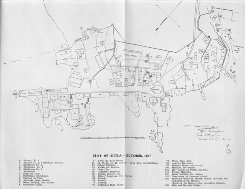
Click for larger image
MAP OF SITKA–OCTOBER, 1867