EL IDRISI COMPARED WITH EL BEKRI.
Reading edition
MAGHRAWAH.
The account of Negroland contained in the foregoing pages is drawn altogether from El Bekrí. So much does his description of Ghánah and the adjoining countries excel in copiousness of detail as well as in clearness, that in all the Arab writers succeeding him, there is hardly a single new particular worth adding to it. Some of these writers, nevertheless, are much better known than El Bekrí; and one of them, El Idrísí, whose work, entitled ‘The Amusement of one desirous of knowing all the Countries of the World,’ was composed about the year 1153, has been long regarded as the first authority on questions relating to the geography of Central Africa. It will be worth while, therefore, to set these two authors side by side, and to compare them carefully, so that we may be able to choose between them when they disagree, and to determine whether the later of the two improved on his precursor.
The first peculiarity of El Idrísí that strikes the attentive reader, is his general reduction of distances in the desert. He begins to contract even in the vicinity of Atlas, and makes Sijilmésah to be only thirteen days distant from Wád Nún; whereas these places must be at least twenty good journeys asunder.[88] But to confine ourselves to the consideration of the principal dimensions of the Ṣaḥrá, we may recal the statement of El Bekrí that Aúlíl was a two months’ journey distant from Wád Nún, going along the shore. Now from Sijilmésah to Aúlíl, which was a greater distance, is reckoned by El Idrísí to be a journey of only forty days. This supposes (since Arguín is exactly 900 miles from Sijilmésah) a rate of 22½ geographical miles a day in a straight line—a rate far exceeding what is practicable on a journey of such a nature and extent.[89] Nor can El Idrísí have here the benefit of any objection to the hypothesis which places Aúlíl at Arguín, since he informs us that Aúlíl was one day’s sail from the mouth of the river called the Nile of the Blacks, by which he must be understood to mean the Senegal. But the mouth of this river is at least two days’ sail from Arguín; so that to make that author consistent with himself, it must be allowed not only that Aúlíl was in the Bay of Arguin, but also that his numerical expressions of distance are, in this instance, too low.[90] In like manner he reduces the distance between Sijilmésah and Silla to forty days; and that from Wád Nún to the latter place to thirty-two days,—viz. seven from Nún to Arkí, and thence twenty-five to Silla; his estimate in each case being less than two-thirds of the reality.[91]
But the same author’s reduction of the longitudinal dimensions of the Great Desert is still more remarkable. Instead of a journey of two months between Aúlíl and Silla, as may be inferred from El Bekrí, whose measures of distance accord strictly with the results of modern inquiry, El Idrísí separates those places by a distance of only sixteen days. Again, he makes Aúdaghost to be but a month from Aúlíl, and twenty-five days from Jermah in Fezzán; so that from the latter place to the shores of the Atlantic, the desert should be crossed in fifty-five days, or less than half of the time actually required for that journey.[92] Again, he states Kúghah to be a month from Dongolah, and six weeks from Ghánah (though the genuineness of the text is here liable to suspicion); and consequently he reduces the whole distance between Dongolah, or the Nile in the east, and the Atlantic Ocean in the west, to a journey of three months and a half, which is not more than a moiety of the true distance.[93]
The incorrectness of El Idrísí exemplified above, cannot be explained away by supposing that he made use of a large scale of measures, or a conventional day’s journey of great length. His contraction of space is not sufficiently uniform to sustain that plea: it operates chiefly on the uninhabited country. Like modern geographers, he seems to have had an invincible dislike to large blanks in a map; and among the expedients to which he had recourse for the purpose of filling them up, was the common one of dilating as much as possible the contiguous inhabited countries. A perfect illustration of this remark is afforded by his description of the course of the Great River in the vicinity of Ghánah.
It has been seen that El Bekrí places the capital of Ghánah not immediately on the Great River, but at a distance of perhaps three days’ journey from it. But Ṣínghánah, with which place he begins his description of Negroland, is described by him as standing on both banks of the river, and having Tekrúr on the south-west. Now in El Idrísí’s geography there is no mention made of Ṣínghánah, but its description is transferred to Ghánah, which is made to stand on both banks of the river, and to have Tekrúr on the south-west. The distance of twenty days, according to El Bekrí, between Silla and Ghánah, is increased by El Idrísí to twenty-four days. The former of these writers thus describes the route eastward and along the river from Ghánah. First, five days to Rás el má, then six days through the country of the Merásah to Tírḳa, where the river turned southwards, and three days further along its banks, to the country of the Seghmárah, which commenced, therefore, at the distance of fourteen days from Ghánah. The same course is thus described by El Idrísí:—From Ghánah, six or eight days to Tírḳa; six more to Merásah; and another six to Seghmárah: so that the fourteen days of his author are here increased to eighteen.[94]
In accordance with the construction given above to El Bekrí’s route from Ghánah to Ghaïárú, El Idrísí makes the portion of the river therein mentioned to form a part of its course below Seghmárah. But the manner in which the latter writer puts together his materials in this place demands attentive consideration. The following are his details of distance and bearing:—
From Samghadah (Sámaḳanda) to Seghmárah, 8 days.
From ditto to Kúghah, eastwards, 10
From ditto to Gharbíl (Ghúntil), 9
From Seghmárah to Gharbíl, southwards, 6
From Gharbíl (Ghúntil) to Ghanárah (Ghaïárú), westwards, 11
From Ghánah to Ghanárah, 11
Thus it appears that El Idrísí makes the river flow first north-eastward from Silla to Ghánah; then eastwards to Seghmárah; then southwards to Ghúntil, and finally westwards again to Ghaïárú.
The Sámaḳanda of El Bekrí, which was four days from Ghánah, and his Kúghah, fifteen days from the same capital, and nine from Anbárah, (which appears to have been near Sámaḳanda,) are evidently the Samghadah and Kúghah of El Idrísí. This writer agrees with his predecessor in making the river flow, first north-eastwards from Silla to Ghánah, then eastwards, and then southwards. So far he seized with some felicity the idea of the general winding of the river. But his turning it westward from Ghúntil can be explained only by supposing that he misunderstood his authority. El Bekrí says, that opposite to the Seghmárah, whose territory extended from the Great River to Tádmekkah, was Kaúkaú. And again, he remarks, that the road to the country of the Remrem went westwards along the river from Kaúkaú. Now this last passage furnishes the explanation of the westward course which El Idrísí has given to the river, if we suppose that he confounded for a moment Kúghah with Kaúkaú.
The River according to El Bekrí.
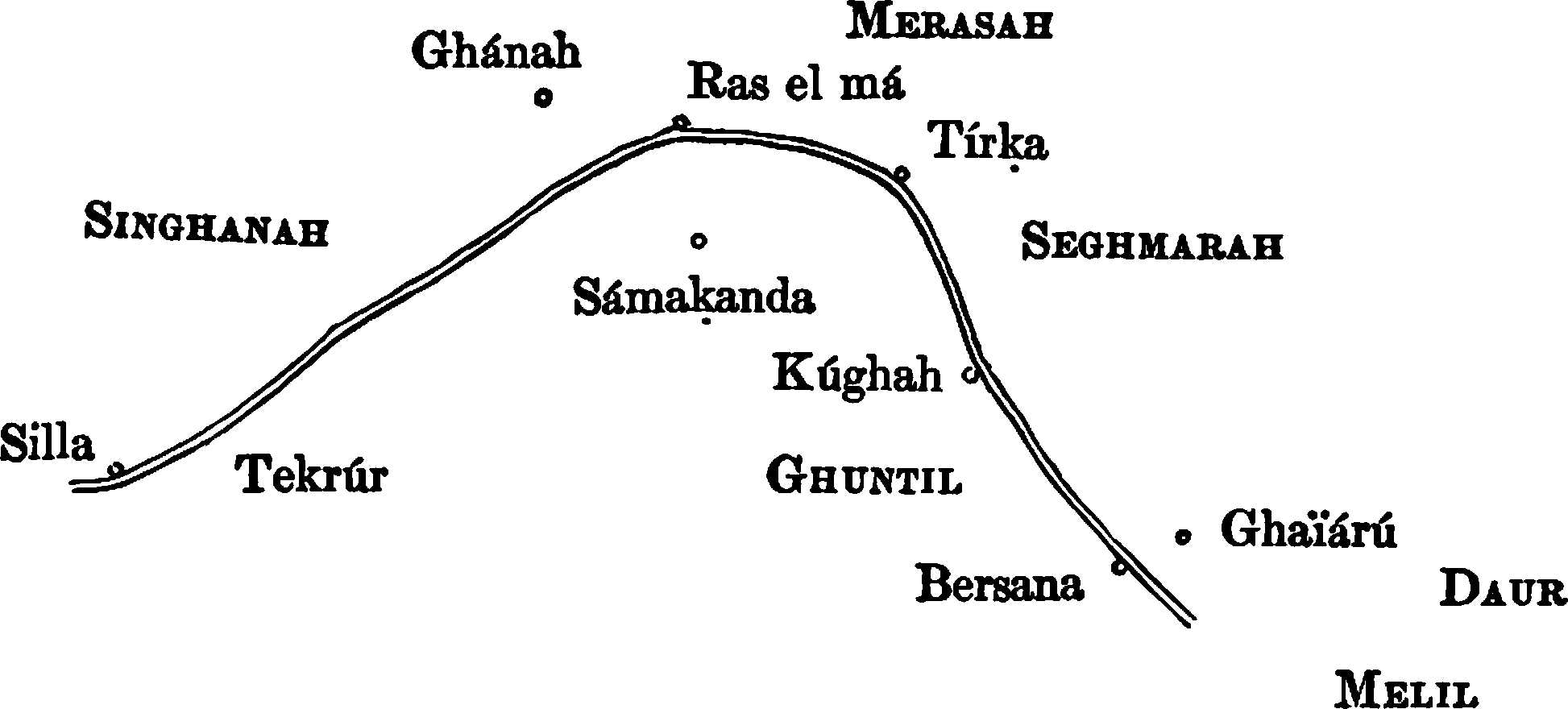
El Bekrí mentions Bersana after Ghaïárú; and accordingly El Idrísí sets this place, under the altered name of Berísa, due west of Ghaïárú, and on the Great River, half way between Silla and Ghánah. The series of names which the latter found in his author he thus arranged in a circle, under the influence of misconception, so as to make it terminate in itself. But the artificial division of climates, by severing Berísa from the group of names to which it originally belonged, fortunately obviated the ready exposure of so absurd a concatenation.[95] The Malilo and Daúr or Daú of El Bekrí are evidently the Malel and Daú of El Idrísí; and in consequence of the same mistake which placed Berísa on the river between Ghánah and Silla, they are brought into the neighbourhood of the latter place. Their character, too, is as much misrepresented as their position. Instead of being countries of some extent and importance, they become, in the pages of El Idrísí, only towns of Lemlem, the wretched inhabitants of which, possessing but few camels, wander over deserts destitute of water;—a picture of Negro poverty, more likely it must be confessed, to originate in the imagination of an Arab, than in the physical character of the country south of the Great River.
The River according to El Idrísí.
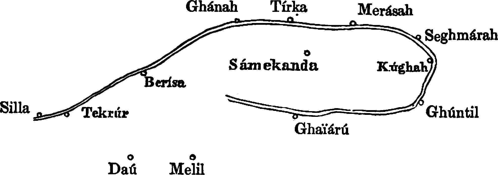
From El Idrísí’s delineation of the Great River we may return with advantage to consider the position assigned by him to Aúdaghost. That town was, according to him, thirty days from Aúlíl, thirty-one from Wergelán, and twenty-five from Jermah. The short distance of fifty-five days herein allowed between Aúlíl and Jermah, will not admit of being applied to a circuitous route. The distance from Wergelán, therefore, which is relatively long, and by reaching far southwards has the effect of elongating the preceding line, must be supposed to be circuitous. And this is a well-founded supposition, inasmuch as the road from Wergelán to Aúdaghost must have passed through Twát, and probably also by Wanzamín. Now the point which satisfies the conditions of distance specified above, and at the same time best eludes surrounding difficulties, will be found to be not far from the 20th parallel of north latitude, and the 1st meridian of east longitude, or about 120 miles east of the position assigned to Aúdaghost in our map. Thus it appears that El Idrísí’s statements respecting the position of Aúdaghost, do not, when taken together, lend the slightest countenance to the hypothesis which makes that place identical with Aghades. For that position, deduced in the strictest possible manner from the assigned conditions, still leads to the conclusion that Ghánah was situate on the northern bend of the river of Tomboktú. But since we likewise learn from the same writer, that it was situate on the western, and not the eastern portion of that northern bend, we have no alternative but to correct his distances with respect to the angle of the river, and to remove Aúdaghost further west, so as to place it exactly half way between Aúlíl and Jermah; the correction, in this case, amounting to only a twenty-second part of the whole distance between those places.
It would be running into needless digression to point out all the contradictions in which El Idrísí involves himself by reducing distances so as to fit them to the frame in which he combines his information, or by expanding details so as to distribute them more equally. It will be here sufficient to have shown that he learned the course of the Great River from El Bekrí, yet that he did not copy his author faithfully, but took liberties with him, which are rendered more conspicuous by the incongruities into which they lead him. He contracts the Desert, spreads out the River; makes Silla on one side only sixteen days distant from the Ocean, and Kúghah, near Seghmárah, on the other, only a month from Dongolah. He wholly misunderstands the account of the lower portion of the river, and by turning the stream westward, he falls into glaring inconsistencies. In conclusion, whatever is reasonable in El Idrísí’s account of Ghánah and its vicinity, is taken from El Bekrí, and nearly all of it which is not taken from El Bekrí is absurd. Nevertheless, his statements, when carefully analysed and freed from misconceptions, plainly indicate that Ghánah was situate near that part of the Great River where Tomboktú now stands.[96]
The only novelty worth notice in El Idrísí’s account of Western Negroland, is his statement respecting the river of Ghánah, which he informs us was navigable in large boats, and flowed into the ocean. Its mouth was one day’s sail from Aúlíl. The river flowing into the ocean near the Bay of Arguin, where it has been shown that the isle and salt mine of Aúlíl were situate, is obviously the Senegal. The short distance of one day’s sail, allowed by the Arab geographer in this case, is in just proportion with all his other measures affecting the area of his map.[97] He supposed the Nile of Ghánah, or Great River of the Interior, to unite with the Senegal, and to run westwards into the ocean. Nor is there any rashness in ascribing to him so great a misconception. Leo Africanus makes a precisely similar statement respecting the river of Tomboktú. Having navigated that river from Tomboktú to Jenni, the latter author affirms most positively that it flows westward to the ocean. The only excuse that can be offered for Leo’s mistake is, that the part of the river with which he was practically acquainted, has little current, and shows no diminution of magnitude as it is ascended; to a careless observer, therefore, it presents nothing capable of controlling speculation, or guiding to a correct inference respecting the course of the stream. Higher up, the hypothesis was less tenable, and so Melli was placed on a branch of the river. Being biassed by the early Arab writers, particularly El Idrísí, Leo zealously adopted their erroneous opinion, which being repeated by De Barros and other writers on African geography, continued in vogue till the middle of the last century, or nearly six centuries after it was first promulgated.[98] El Idrísí states that salt was carried from Aúlíl to the mouth of the Nile, one day distant, and then up that stream to Silla, Ghánah and Kúghah. Modern authorities, on the other hand, have reported the Senegal to be navigable up to Jenni (two days from Silla), Tomboktú and Gago, at which point their information always terminated. And herein is another point of resemblance between Ghánah and Tomboktú; inasmuch as they hold similar positions in the hypothetical system, connecting the Senegal with the Great River of the Interior.[99]
The Western Desert is represented by El Idrísí with the changed aspect consequent on the movement of the Morabites. The Lumtúnah had gone northwards to Morocco, and the Benú Goddálah, to whatever quarter they had migrated, were no longer predominant in the south-western portion of the Ṣaḥrá. The inhospitable tract extending between the desert of Tíser and the Ocean, is named by El Idrísí Kamnúdíyah, the chief town of which was half way between Silla and Arkí. South of Kamnúdíyah, he places a country, the name of which, vitiated by copyists, occurs under a great variety of forms, as, for example, Maghráwah, Meghrárah, Meghzárah, &c. Of these readings, the first alone admits of a satisfactory explanation, and shall therefore be here adopted.[100] Maghráwah lay to the west of Ghánah, and as it extended from Aúlíl, on the sea shore, to Silla and Tekrúr inclusively, it also embraced a territory lying to the south of that State.[101] The country named by El Idrísí Maghráwah is therefore obviously the same which a century earlier had been occupied by the Benú Goddálah, and the change of its name may be naturally ascribed to the revolution which carried away the latter people with the hordes of the Morabites. The Arab historians are silent with respect to those who took the place of the Benú Goddálah; but the want of information may be in this instance supplied by a very probable conjecture.
When the Morabites, having subjugated Sús, Darʿah, Sijilmésah, and the province wherein they afterwards founded Morocco, still continued to press northwards, they met with a vigorous resistance from the Maghráwah, who had long ruled over Fez and its dependencies, and who now united with the Miknésah and other Zenátah tribes to oppose the invaders.[102] The victory fell to the Morabites, who entered Fez in triumph in A.D. 1067. But, grown negligent through continual success, they were soon after taken by surprise, overpowered, and expelled. Their enthusiasm, however, was not to be subdued by slight reverses; they returned to the struggle, and again entered Fez in 1069, slaughtering, it is said, 20,000 of the Maghráwah, whose sway in the west thus terminated, after a continuance of just a century.[103]
Of the fortunes of the defeated tribes, there is nothing recorded; but the general tenor of the history of Barbary justifies the supposition that they betook themselves to the desert.[104] In 1084, Yúsef ben Táshifín, the Amír or chief of the Morabites, sent messengers into the Ṣaḥrá, to the Lumtúnah, Goddálah, and Masúfah, announcing to them that he possessed extensive territories, well watered, which he was ready to bestow on the first comers; “and in a few days,” says the historian, “the whole land of Maghreb [Western Barbary and Morocco] was filled with colonists from the Lumtúnah and the other tribes of the desert.”[105] It is manifest that the Maghráwah, and their adherents, must have deserted the fine country around Fez, before the half-wild tribes of the Ṣaḥrá were called in to occupy it; and it is probable that, in the course of revolution, they stepped into the place of the Benú Goddálah soon after the latter had accepted the invitation sent to them to fill the vacancy left by the expelled tribes. Thus we are led to conclude, that the territory of the Benú Goddálah passed into the possession of the Maghráwah at a period subsequent to, and probably not far removed from, the year 1084.
The natural and probable supposition, that the tribes expelled from Mauritania by the Morabites changed places with the latter, and fixed themselves in the desert at the same time that their conquerors rushed into the occupation of the cultivated country, explains at once the great difference between the accounts given of the Western Desert by two authors, one of whom wrote seventeen years before the migration referred to, and the other sixty-nine years after that event. Nevertheless, the desire inherent in the human mind to give importance to whatever is obscure, favoured by the corruption of the name Maghráwah, and the garbled accounts of the country so designated, may revolt against a conjecture which confines that name to the Desert, instead of extending it over a large tract of Negroland. Yet El Idrísí plainly states that Maghráwah was a desert; that it was bounded on the north by the middle tract of the Ṣaḥrá, named Kamnúdíyah; and that it extended from Aúlíl, which was its capital, to Silla and Tekrúr; so that it must have been on the northern side of the Great River, of which the Senegal, according to his system, was a part.[106] The same writer indeed includes Silla and Tekrúr in Maghráwah, whence it may be inferred that the exiles from Fez soon obtained the ascendancy due to superior civilization, and became the rulers of their black neighbours. But since the Arabs nowhere mention the Mandingoes, Serakholies, Fúlahs, Wolofs, or other black nations between Silla and the ocean, it must be presumed that they had no direct intercourse with that part of Negroland, and knew nothing of it; and, besides, it is unreasonable to suppose that they described the country south of the Senegal under the general name of Maghráwah, of which general name, in any shape, not the least trace now remains in the region to which it is supposed to have been applied. North of the river, on the other hand, the disappearance of a particular tribe, or of its name; or a loss on the part of any tribe of that predominance which determines the name of a territory, is much more explicable. And if it be admitted that the name Aúlíl or Aúlílí was derived from that of Walílí, the chief place of the Maghráwah and the capital of Western Barbary under their dominion, then the presumption will arise, that some of that nation were always mingled with the Goddálah, and carried the local name to which they were attached, from the shores of the Mediterranean to those of the Ṣaḥrá.[107]