NATIONAL GEOGRAPHIC MAGAZINE.
Reading edition
Vol. I. 1889. No. 4.
IRRIGATION IN CALIFORNIA.
BY WM. HAMMOND HALL.
Mr. President and Gentlemen of the Society:
When I was invited to address this society I had no material at hand on the subject. I have come to the east without any notes or memoranda whatever, from which to prepare a lecture or address, no statistical data which would make a paper valuable, no notes of characteristic facts to render an address interesting, and no time to write anything to guide me in any way to a proper treatment of the subject. Some of your members have thought that I have written something worthy of being read, and hence this invitation to address you. But, even if they are right, people who can write cannot always talk, so if I fail in this address, I shall hope, on the basis of their opinion, that you will find in the reports I have written something worthy of reading. The subject has been announced as the "Problems of Irrigation in the United States." I should like very much to speak broadly on that subject, but I am unable to do so, for the reasons I have given, and shall have to speak rather of irrigation in California, trusting that something which is said, may, perchance, be valuable in relation to the subject at large. Irrigation in the far west, generally, is attracting a vast deal of attention. This is particularly the case on the Pacific Coast—the field with which I am specially acquainted. I apprehend that although many gentlemen present have a far-reaching and definite appreciation of the subject at large, many others do not appreciate the value and importance of irrigation. In the arid parts of California (for we do not admit that California is as a whole arid) it is a vital matter. There it is a question of life, for the people. Not more than one-sixth of the tillable area in the State can sustain a really dense population, without irrigation; two thirds of it will not sustain even a moderate population, without irrigation; while one third will not sustain even a sparse population, without such artificial watering. Think well over these facts. They are very significant. I doubt whether they are generally appreciated in California itself.
I have no doubt many persons are familiar with the geography of the State, but, doubtless, some are not. California has a coast line of 800 miles and a width of from 140 to 240 miles. It is traversed almost throughout its length by a great mountain chain extending along near the eastern boundary, which is called the Sierra Nevada, and by a lesser range, more broken and less unified, running parallel to the coast, called the Coast Range, the southern extension of which, after joining the Sierra Nevada, is called the Sierra Madre, and at the further extremity, the San Jacinto and San Diego mountains. Within the interior of the State, looked down upon by the Sierra Nevada on the east, and closed in by the Coast Range on the west, is the great interior basin—the valley of the San Joaquin and Sacramento rivers—forming a plain 450 miles long, with an average width of from 40 to 60 miles. Outside of the Sierra Madre in the southern part of the State, and within the Coast Range, is another interior valley, nearly 100 miles in length and from 20 to 30 miles in width, and outside of the Coast Range, and lying next to the ocean, is a plain whose length is from 60 to 70 miles, and width 15 to 20 miles. These three areas—the great interior valley, the southern interior valley, and the coast plain of the south—are the principal irrigation regions of the State. Numbers of smaller areas, as those in San Diego county, come in as irrigation regions of less importance, and the scattering valleys along the Coast Range farther north, as the Salinas, etc., will come forward in the future as important irrigable districts of the State. Still further north, in the interior, there are the great plains of Lassen and Mono counties, and some scattering valleys in Shasta county, where irrigation is also practiced or is being introduced, and these are on a par with the districts of San Diego county, in the matter of rank as irrigation regions. East of the Sierra Nevada, and at their base, lies the Owen's river country, an area suitable for irrigation, where irrigation is necessary and where it is being introduced. Upon the great Mojave desert and the Colorado desert, there is at present no irrigation. The water supply is very scanty. This is an irrigation region of the future, but it is not regarded by Californians as a practicable one at present.
With this general idea of the State, we will now look at the rainfall and water supply. The State contains 157,440 square miles of territory, of which 17,747 drain into the ocean north of the Golden Gate, 21,665 drain into the ocean south of the Golden Gate, 55,942 drain into the interior basins, and 62,086 drain out at the Golden Gate. Of this territory which drains out by the Golden Gate, 26,187 square miles comprise the Sacramento valley, 31,895 square miles the San Joaquin valley, and 4,004 the country draining directly to the bays, making the 62,086 given above as the whole area.
The necessity for irrigation in California, and the relative necessity in different parts of the State, are shown by the distribution of rainfall. The San Joaquin valley has an average of less than 10 inches of rainfall, the Sacramento has an average of between 10 and 20 inches. The great deserts of the Mojave and Colorado have an average of less than 10 inches, and in certain localities only 3 to 6 inches. The Salinas valley, a small portion of the coast above Los Angeles, and a portion of the interior valley of the south, have also an average of less than 10 inches.
So, we may say, that the great irrigation regions of California have average amounts of rainfall varying from about 6 up to 20, but generally less than 10 inches. This rain is distributed in four or five months of each year, with some slight showers in one or two months other than these; the remainder of the year being absolutely dry, with no rainfall whatever. Hence, you will see at once, the necessity for the artificial application of water in California. In the older countries of Europe, where irrigation has been practiced for centuries, for instance, in Spain, where water is used more extensively than in California, the annual mean rainfall ranges between 10 and 25 inches. In the irrigation regions of France, the mean rainfall ranges from 10 to 40 inches; in the irrigation regions of Italy, the rainfall is between 20 and 35 inches—for instance, in the valley of the Po, the classic land of irrigation, the annual precipitation is from 25 to 35 inches. There are none of these European irrigation regions where the rainfall is less than 10, and generally it is over 20 inches. But you will see that the most of the Californian irrigation regions have less than 15 inches, some less than 10, and the greatest rainfall of any large irrigable region in California is 18 inches, or, exceptionally, for smaller regions, 25 inches; while in Europe, the maxima are from 25 to 40 inches in countries where irrigation has long been practiced. It follows, then, that there is no place in Europe where it is so much needed as over a large part of California. Another reason why the necessity is felt in our Pacific Coast State, is found in the character of our soils; and not alone the surface soils, but the base of the soil—the deep subsoils. We have soils exceptionally deep; soils which extend below the surface to 50 feet, underlaid by loose sand and open gravels, so that the rainfall of winter is lost in them. The annual rain seldom runs from the surface. It follows that these lands are generally barren of vegetation without the artificial application of water.
Considering now the sources of water-supply: we have in the southern part of the State many streams which flow only for a few weeks after rainfall, and other streams which run two or three months after the rainy season. But there is not a stream in all California south of the Sierra Madre (except the Colorado, which has it sources of supply outside of the State) which flows during the summer with a greater volume than about 70 to 80 cubic feet per second—a stream 15 feet in width, 2 feet deep, and flowing at the rate of 2½ to 3 feet per second—a little stream that, in the eastern part of the continent, would be thought insignificant. The largest stream for six months in the year, in all southern California, is the Los Angeles river. The Santa Aña river, the next largest, flows from two sevenths to one third as much; the San Gabriel, the next largest, has perhaps two thirds or three fourths as much as the Santa Aña; and so, a stream which will deliver as much water as will flow in a box 4 feet wide and 1½ feet deep, at a moderate speed, during summer months, would be regarded as a good-sized irrigation feeder in that southern country. In the greater interior basin or central valley, we find other conditions. Here we have a different class of streams. The great Sierra Nevada receives snow upon its summits, which does not melt till May or June and July. The melting of these snows is the source of supply of the streams; so that, while in far southern California, with two or three exceptions, the greater flow of water in the streams is almost gone by June, in this central region it is the period of the height of irrigation, and the streams are flowing at their maximum. Kern river presents about 2000 to 3000 cubic feet of water per second; King's river presents in the maximum flow of the season about twice to three times as much as Kern river; the Tuolumne river about as much as King's. As we go farther north, the Sacramento river presents more than three times as much as the Tuolumne, so that in the northern part of the great valley, where the rainfall on the valley itself is greatest, and, consequently, the necessity for irrigation is least, the irrigation supply increases; and conversely, the greatest area of irrigation in the valley and the greatest necessity for it, is, in general, where the water supply is least.
About 100 years ago irrigation was commenced in California. The Roman Catholic priests, coming from Mexico where irrigation had long been practiced, introduced it. They established missions among the Indians, started cultivation, and by the labor of these Indians built the original irrigation works. The practice of irrigation was extended in San Diego county, as far as we are able to trace, to several thousand acres; in San Bernardino county in the southern interior valley, they thus cultivated and watered, perhaps 2000 acres; and in Los Angeles county there were possibly 3000 acres irrigated under Mexican rule. Traces of the old mission works are found in San Diego, San Bernardino and Los Angeles counties, and as far north as Monterey county.
Then came the gold fever, when canals were dug throughout the foot-hills of the western slope of the Sierra Nevada, for the supply of water for the mining of gold; and these canals have since, in many instances, been turned into feeders for irrigation. Several thousand miles of irrigation ditches have thus been created from old mining ditches. In 1852, a band of Mormons came from Salt Lake into the San Bernardino valley; they bought a Mexican grant rancho there, took possession of some old mission works, constructed others and started irrigating. That was probably the first irrigation colony, on a large scale, composed of others than Mexicans, in California. In 1856, some Missouri settlers went into the valley of Kern river, diverted water from that stream, and commenced irrigation upon a small scale. In 1858, the waters of Cache creek, in the Sacramento valley, were taken out for irrigation. In 1859, the waters of King's river were taken out and utilized for irrigation. These instances represent in general outline the commencement of irrigation in the State. Now we have in the neighborhood of 750,000 or 800,000 acres actually irrigated each year, and that represents what would ordinarily be called an irrigation area of 1,200,000 acres; and there are commanded by the works—reasonably within the reach of existing canals—an area of about 2,500,000 acres.
In the organization of irrigation enterprises there is great diversity. Commencing with the simplest form, we have a ditch constructed by the individual irrigator for his own use; we have then successively ditches constructed by associated irrigators without a definite organization, for the service of their own land only; ditches constructed by regularly organized associations of farmers, with elected officers; works constructed by farmers who have incorporated under the general laws of the State and issued stock certificates of ownership in the properties, for the service of the stockholders only; works where incorporations have been formed for the purpose of attaching water stock to lands that are to be sold, bringing in the element of speculation; then works where the organization has been effected with a view of selling water-rights; and finally, organizations that are incorporated for the purpose of selling water. There is a great difference between the principles of these methods of organization, and the practical outcome is a great difference in the service of water and in the duty of water furnished by them. In selling water, measurement of volume is made by modules—the actual amount of water delivered is measured—or it is sold by the acre served, or in proportional parts of the total available flow of the season.
The general character of the irrigation works of the State varies very much with the varying conditions under which it is practiced. In the San Joaquin valley, King's river, for instance, comes out of the mountains nearly on a level with the surface of the plain, cutting down not more than a few feet below its banks; and hence but little labor is required to divert its waters out upon the lands to be irrigated; but farther north, the Tuolumne, as another example, comes out of the mountains in a deep cañon, and the foot-hills extend far down the plain on each side. It is easily seen, then, that it will require a million or more dollars to divert from the latter stream the amount of water diverted from King's river by the expenditure of a few months' work, by a small force of the farmers themselves. On King's river, individual and simple coöperative effort is sufficient to bring water enough upon the plains to irrigate thousands of acres, while in the case of the Tuolumne river it is absolutely necessary to have associated capital in large amount—an entirely different principle of organization from that which was originally applied on King's river and the Kern and other rivers in the southern part of the great central valley. In discussions on the subject of irrigation some people have advanced the idea that the works should be undertaken by the farmers, and that capital should have nothing to do with them. That may do very well where the physical conditions will admit of such a course, and where nothing but the farmers' own service depends upon it; but the great majority of the streams of California are of such a character that the work of the farmers can avail nothing. There must be strong associations and large capital. For this purpose special laws are required. On the Santa Aña, in San Bernardino county, water has been easily diverted, and such is the case with every stream in the interior valley of San Bernardino and Los Angeles counties.
Capital for the first works was not required. The water was procured by primitive methods and the works were simple. But in San Diego, an entirely different condition of affairs prevailed. There the waters are back in the mountains, twenty or twenty-five miles from the coast, and the irrigable lands are close along the coast, or within ten or twelve miles of it. To bring the water out of these mountains requires the construction of ditches following the mountain sides for 20 to 35 miles. But simple ditches do not answer, because of the great quantity of water lost from them. So the companies have resorted to fluming, and even to lining the ditches with cement. Thus in San Diego, individual effort is out of the question. Farther north again, in the great interior valley, King's river is a stream where coöperative and individual effort have been efficient, although it requires a greater amount of capital there than in the southern interior valley. In the southern interior valley, perhaps, $10,000 would often build a ditch and divert all the water that the supply would furnish. On King's river the works have cost from $15,000 to $80,000 each; on Kern river the works have cost from $15,000 to $250,000 each; and on the Tuolumne they will cost from $1,000,000 to $1,200,000 apiece. On Merced river, the cost has been $800,000 for one work. Taking the streams from San Joaquin river north, that come out of the Sierra Nevada, up to the northern end of the valley where the Sacramento river enters it, every important stream comes into the valley within a deep gorge. The beds of several of the northern streams are so filled up with mining debris that diversion from them would be comparatively easy, but in their natural state there is not an important stream north of the San Joaquin which could be utilized for irrigation by any other means than through the agency of capital in large amount. On the west side of this great valley the tillable strip is comparatively narrow. It is on the lee side of the coast range of mountains. Precipitation is made first on the seaward face of the Coast Range, and then crosses the valley, dropping upon the inland face of the outer range very little more than upon the valley itself, where the precipitation is only about 10 inches. So that we have no streams coming out of the Coast Range into the southern part of the interior valley specially noteworthy as irrigation feeders. But as we go northward the Coast Range becomes wider, and the big mountain basin containing Clear Lake furnishes a large supply of water to Cache Creek, probably enough for 10,000 acres. Stony Creek flows between two ridges of the Coast Range, and out on to the plains, furnishing about the same amount of water; but still there are no streams from the Coast Range into the valley that are comparable with those of the Sierra Nevada. In the northeastern corner of the State, on the great plains of Modoc, we have the Pitt river, a stream of very considerable volume, but its waters are in comparatively deep channels, not very well adapted to diversion, and the consequence is, they have been utilized to a very small extent, only on small bottom-land farms. The whole stream can be utilized, however, and the country is thirsting for water.
The practice of irrigation in California is as diverse as it could well be. California, as you know, covers a very large range in latitude, but a greater range in the matter of climate and adaptability to the cultivation of crops. In the southern portion of the State, the orange and the banana and many other semi-tropical fruits flourish. In some localities along the foot-hills of the Sierra Nevada, also, those fruits flourish, particularly the orange and the lemon. In the valley of San Joaquin, wheat is grown by irrigation, and in some places profitably, and in Kern county quite profitably (were it not for high transportation charges), because the cost of distributing and applying water has been reduced to a minimum. There the lands have been laid out with as much care and precision as the architect would lay out the stones in a building and the mason would place them. Irrigation is conducted in some Kern river districts with the greatest ease, scarcely requiring the use of the shovel. The lands are so laid off with the check levels that by simply opening gates in the proper order, as the irrigation superintendents know how, the waters flow out and cover the successive plats or "checks" in their order, without leaving any standing water, and finally flowing off without material waste. This is the perfection of irrigation by the broad or submerging system,—a method wherein the slope of the ground is first ascertained, platted by contours, and the checks to hold the water, constructed with scrapers, are then run out on slight grade contours—not perfectly level, but on very gentle slopes.
There is no portion of the far southern part of the State where the check method is applied as it is in Kern county. The practice in San Bernardino is to irrigate entirely by running water in rills between the rows of plants. Orange trees planted 24 to 30 feet apart are irrigated by rills in plough furrows, 5 to 8 between rows, down the slope of the orchard, which slope varies from about 1 foot in a hundred to 4 or 5 in a hundred. In Los Angeles county they make banks about a foot high around each individual tree, forming basins 5 or 6 to 10 or 12 feet in diameter according to the size of the tree. Into these the water is conducted by a ditch, and the basin being filled, the water is allowed to remain and soak away. The low, nearly flat valley lands, when irrigated, are generally divided into square "checks," without respect to the slope of the ground, and the surface is simply flooded in water standing 6 inches to a foot in depth.
In the northern part of the State, in Placer and Yuba counties, clover is grown on hills having side slopes of 10 to 15 feet in a hundred, and irrigated in plough furrows cut around on contours—which furrows are about 5 to 10 feet apart horizontally—and the water is allowed to soak into the ground from each such furrow.
These are the five principal methods of applying water: by the check system; by rills; by the basin method; by the basin method as applied to low valleys; and by contour ditches on hill sides. The method selected for any particular locality is determined not alone by the crop to be cultivated, but also by the slope of the land and the character of the soil. For instance, on lands where oranges are cultivated, in the southern part of the State, where rills are most generally used, water cannot be applied by the flooding system, for the reason that irrigation would be followed by cracking of the soil, so that the trees would be killed. It is necessary on such land to cultivate immediately after irrigation, and the method of application is governed more by the soil than by the character of the crop.
We find in California very marked and important effects following irrigation. For instance, taking the great plains of Fresno, in the San Joaquin valley: when irrigation commenced there twenty years ago, it was 70 to 80 feet down to soil water—absolutely dry soil for nearly 80 feet—and it was the rule throughout the great plain, 20 miles in width and 25 miles in length, that soil water was beyond the reach of the suction pump; now, in places, water stands on the surface, rushes grow, mosquitos breed, malarial fevers abound, and the people are crying for drainage; and lands, whose owners paid from five to twenty dollars per acre for the right to receive water, now need drainage, and irrigation is considered unnecessary. The amount of water taken from King's river which was, a few years ago, regarded as not more than sufficient for one tenth of the land immediately commanded and that seemed to require it, is now applied to a fourth of the whole area; so that if irrigation keeps on, the time will come when the whole country will require draining.
In a district, where water is applied by the broad method, I saw in 1877 enough water, by actual measurement of flow, put on 20 acres of land to cover it 18 feet deep, in one season, could it all have been retained upon it. It simply soaked into the ground, or flowed out under the great plain. Taking cross sections of this country, north and south and east and west, I found that where the depth to soil water had, before irrigation, been about 80 feet, it was then 20, 30, 40 or 60 and more feet down to it. The soil water stood under the plain in the form of a mountain, the slope running down 40 to 50 feet in a few miles on the west and north. On the south and southwest the surface of this water-mountain was much more steep. In the Kern river country, we have a somewhat similar phenomenon. Irrigation, in the upper portion of the Kern delta, affects the water in the wells 6 or 8 miles away. As I remember the effect is felt at the rate of about a mile a day, that is to say, when water is used in irrigating the upper portion of the delta, or of Kern island, as it is called, the wells commence to rise a mile away in twenty-four hours, and five miles away in perhaps five days.
In the southern portion of the State, in San Bernardino county, at Riverside, we find no such effect at all. There it was 70 to 90 feet to soil water before irrigation and it is, as a general rule, 70 to 90 feet still. Water applied on the surface in some places has never even wet the soil all the way down, and wells dug there, after irrigation had been practiced for years, have pierced dry ground for 25 or 30 feet before getting down to where soil waters have wetted it from below. The consequences of these phenomena are twofold. In the first place, in the country that fills up with water, the duty of water—the quantity of land which a given amount of water will irrigate—has increased. Starting with a duty of not more than 25 acres to a cubic foot of water per second, we now find that, in some localities, this amount irrigates from 100 to 160 acres; and that some lands no longer require irrigating. In the southern portion of the State, however, the cubic foot of water irrigates no more than at first, and it is scarcely possible that it will ever irrigate much more. The saving, as irrigation goes on in the far southern portion of the State, will be effected chiefly through the better construction of canals and irrigation works of delivery and distribution. In Tulare valley, the duty of water will increase as the ground fills up.
In Fresno, a county which was regarded as phenomenally healthy, malarial fevers now are found, while in San Bernardino, at Riverside, such a thing is rarely known. Coming to Bakersfield, a region which before irrigation commenced was famed for its malarial fevers—known as unhealthful throughout all the State—where soil water was originally within 15 feet of the surface, irrigation has almost entirely rid it of the malarial effects. Chills and fever are rare now, where before irrigation they were prevalent. What is the reason that where chills and fever prevailed, irrigation has made a healthful country, while where chills and fevers were not known, irrigation has made it unhealthful? I account for it in this way: in the Kern river country before irrigation was extensively introduced, there were many old abandoned river channels and sloughs, overgrown with swamp vegetation and overhung by dense masses of rank-growing foliage. Adjacent lands were in a more or less swampy condition; ground waters stood within 10 or 20 feet of the surface, and there was no hard-pan or impermeable stratum between such surface and these waters. In other words, general swampy conditions prevailed, and malarial influences followed by chills and fevers were the result. Irrigation brought about the clearing out of many of these old channel ways, and their use as irrigating canals. The lands were cleared off and cultivated, fresh water was introduced through these channels from the main river throughout the hot months, and the swamp-like condition of the country was changed to one of a well-tilled agricultural neighborhood with streams of fresh water flowing through it; and the result, as I have said, was one happy in its effect of making the climate salubrious and healthful.
Considering now the case of the King's river or the Fresno country, the lands there were a rich alluvial deposit, abounding in vegetable matter which for long ages perhaps had been, except as wetted by the rains of winter, dry and desiccated. Soil water was deep below the surface. Then irrigation came. Owing to the nature of the soil, the whole country filled up with the water. Its absorptive qualities being great and its natural drainage defective, the vegetable matter in the soil, subjected to more or less continued excessive moisture, has decayed. The fluctuation of the surface of the ground waters at different seasons of the year—such surface being at times very near to the ground surface, and at other times 5 or 6 feet lower—has contributed to the decaying influences which the presence of the waters engendered. The result has been, when taken with the general overgrowth of the country with vegetation due to irrigation, a vitiation of the atmosphere by malarious outpourings from the soil. The advantage of the pure atmosphere of a wide and dry plain has been lost by the miasmatic poisonings arising from an over-wet and ill-drained neighborhood, with the results, as affecting human healthfulness, of which I have already spoken. The remedy is of course to drain the country. The example is but a repetition of experiences had in other countries. The energy and pluck of Californians will soon correct the matter.
George P. Marsh, in his "Man and Nature," laid it down as a rule that an effect of irrigation was to concentrate land holdings in a few hands, and he wrote an article, which was published in one of our Agricultural Department reports, in which he rather deprecates the introduction of irrigation into the United States, or says that on this account it should be surrounded by great safeguards. He cited instances in Europe, as in the valley of the Po, where the tendency of irrigation had been to wipe out small land holdings, and bring the lands into the hands of a few of the nobility. He cited but one country where the reverse had been the rule, which was in the south and east of Spain, and pointed out the reason, as he conceived it, that in south and southeastern Spain the ownership of the water went with the land and was inseparable from it, under ancient Moorish rights. It is a fact, that where the ownership of water goes with the land, it prevents centering of land ownership into few hands, after that ownership is once divided among many persons, in irrigated regions. But Mr. Marsh overlooked one thing in predicting harm in our country; that is, that it will be many years before we will get such a surplus of poor as to bring about the result he feared. In California, the effect of irrigation has not been to center the land in the hands of a few. On the contrary, the tendency has been just the other way. When irrigation was introduced it became possible for small land holders to live. In Fresno county, there are many people making a living for a family, each on 20 acres of irrigated land, and the country is divided into 20 and 40-acre tracts and owned in that way. In San Bernardino the same state of things prevails. Before irrigation, these lands were owned in large tracts, and it was not an uncommon thing for one owner to have 10,000 to 20,000 acres of land. So that the rule in California, which is the effect of irrigation, is to divide land holdings into small tracts, and in this respect, also, irrigation is a blessing to the country. It enables large owners to cut up their lands and sell out to the many. Land values have advanced from $1.25 in this great valley to $50, $150 and even $250 per acre, simply by attaching to the land the right to take or use water, paying in addition an annual rental: in the southern portion of the State, they have advanced from $5 and $10 to $500 and even $1000 an acre, where the land has the right to water; and many calculations have been made and examples cited by intelligent and prominent people, to show that good orange land or good raisin-grape land with sufficient water supply is well worth $1000 an acre. Water rights run up proportionately in value. A little stream flowing an inch of water—an amount that will flow through an inch square opening under four inches of pressure—in the southern part of the State, is held at values ranging from $500 to $5000. Such a little stream has changed hands at $5000, and not at boom prices either. In the interior prices are much less, being from about a quarter to a tenth of those in the far southern part of the State.
Fully one fourth of the United States requires irrigation. When I say that, I mean that fully one fourth the tillable area of our country requires irrigation, in order to support such a population as, for instance, Indiana has. The irrigated regions of Italy support populations of from 250 to 300 people to the square mile; of south France, from 150 to 250 people to the square mile; of southeast Spain, from 200 to 300. When we have 50 to 100 to the square mile in an agricultural region we think we have a great population.
The great interior valley of California will not support, without irrigation, an average of more than 15 to 20 people per square mile. Irrigate it and it will support as many as any other portion of the country—reasonably it will support 200 to the square mile. I have no doubt that the population will run up to ten or twelve millions in that one valley, and there are regions over this country from the Mississippi to the Pacific, millions of acres, that can be made to support a teeming population by the artificial application of water. And why has it not been done before? Simply for the reason that there is a lack of knowledge of what can be done and a lack of organization and capital to carry out the enterprises.
The government has recently placed at the disposal of the United States Geological Survey an appropriation for the investigation of this subject, to ascertain how irrigation can be secured, the cost of irrigation works, and point out the means for irrigation, in the arid regions. It is one of the wisest things Congress ever did; wise in the time and in the subject. The time will soon come when the question would have been forced upon the country, and the wisdom of preparing for that time cannot be too highly commended.
ROUND ABOUT ASHEVILLE.
BY BAILEY WILLIS.
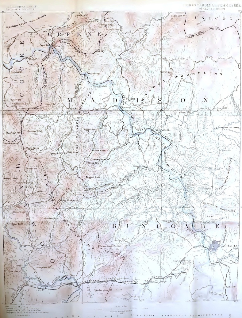
A broad amphitheatre lies in the heart of the North Carolina mountains which form its encircling walls; its length is forty miles from north to south and its width ten to twenty miles. At its southern gate the French Broad river enters; through the northern gate the same river flows out, augmented by the many streams of its extensive watershed.

SECTION FROM THE CUMBERLAND PLATEAU TO THE BLUE RIDGE. Natural profiles.
From these water-courses the even arena once arose with gentle slope to the surrounding heights and that surface, did it now exist, would make this region a very garden, marked by its genial climate and adequate rainfall. But that level floor exists no longer; in it the rivers first sunk their channels, their tributaries followed, the gullies by which the waters gathered deepened, and the old plain was thus dissected. It is now only visible from those points of view from which remnants of its surface fall into a common plane of vision. This is the case whenever the observer stands upon the level of the old arena; he may then sweep with a glance the profile of a geographic condition which has long since passed away.
Asheville is built upon a bit of this plain between the ravines of the French Broad and Swannanoa rivers, now flowing 380 feet below the level, and at the foot of the Beau-catcher hills; toward which the ground rises gently. The position is a commanding one, not only for the far reaching view, but also as the meeting place of lines of travel from north, south, east, and west. Thus Asheville became a town of local importance long before railroads were projected along the lines of the old turnpikes. The village was the center of western North Carolina, as well of the county of Buncombe, and was therefore appropriately the home of the district Federal court. A May session of the court was in progress nine years ago when I rode up the muddy street from the Swannanoa valley. Several well-known moonshiners were on trial, and the town street was crowded with their sympathizers, lean mountaineers in blue and butternut homespun. Horses were hitched at every available rack and fence, and horse trading was active. Whiskey was on trial at other bars than that of the court, and the long rifle, powder-horn and pouch had not been left in the mountains. To a "tenderfoot" (who had the day before been mistaken for a rabbit or a revenue officer!) the attentions of the crowd were not reassuring.
The general opinion was, I felt, akin to that long afterward expressed by Groundhog Cayce: "It air an awful thing ter kill a man by accident;" and I staid but a very short time in Asheville.
Riding away toward the sunset, I traversed the old plain without seeing that it had had a continuous surface. I noted the many gullies, and I lost in the multitude of details the wide level from which they were carved. That the broader fact should be obscured by the many lesser ones is no rare experience, and perhaps there is no class of observations of which this has been more generally true than of those involved in landscape study. But when once the Asheville plain has been recognized, it can never again be ignored. It enters into every view, both as an element of beauty and as evidence of change in the conditions which determine topographic forms. Seldom in the mountains can one get that distance of wooded level, rarely is the foreground so like a gem proportioned to its setting; all about Asheville one meets with glimpses of river and valley, sunken in reach beyond reach of woodland which stretch away to the blue mountains. The even ridges form natural roadsites, and in driving one comes ever and anon upon a fresh view down upon the stream far across the plain and up to the heights. And to the student of Appalachian history, the dissected plain is a significant contradiction of the time honored phrase, "the everlasting hills." That plain was a fact, the result of definite conditions of erosion; it exists no more in consequence of changes. What were the original conditions? In what manner have they changed? Let us take account of certain other facts before suggesting an answer. Of the mountains which wall the Asheville amphitheatre, the Blue Ridge on the east and the Unaka chain on the west are the two important ranges. The Blue Ridge forms the divide between the tributaries of the Atlantic and those of the Gulf of Mexico, and the streams which flow westward from it all pass through the Unaka chain. It would be reasonable to suppose that the rivers rose in the higher and flowed through the lower of the two ranges, but they do not. The Blue Ridge is an irregular, inconspicuous elevation but little over 4000 feet above the sea; the Unaka mountains form a massive chain from 5000 to 6500 feet in height. That streams should thus flow through mountains higher than their source was once explained by the assumption that they found passage through rents produced by earth convulsions; but that vague guess marked the early and insufficient appreciation of the power of streams as channel cutters, and it has passed discredited into the history of our knowledge of valley-formation. That rivers carve out the deepest cañons, as well as the broadest valleys, is now a truism which we must accept in framing hypotheses to account for the courses of the French Broad and other similar streams. Moreover, since waters from a lower Blue Ridge could never of their own impulse have flowed over the higher Unaka, we are brought to the question, was the Blue Ridge once the higher, or have streams working on the western slope of the Unaka range (when it was a main divide), worn it through from west to east, capturing all that broad watershed between the two mountain ranges? Either hypothesis is within the possibility of well established river action, and both suggest the possibility of infinite change in mountain forms and river systems. Without attempting here to discriminate between these two hypotheses, for which a broader foundation of facts is needed, let us look at the channel of the French Broad below Asheville, in the river's course through the range that is higher than its source. Descending from the old plain into the river's ravine, we at once lose all extended views and are closely shut in by wooded slopes and rocky bluffs. The river falls the more rapidly as we descend, and its tributaries leap to join it, the railroad scarce finding room between the rocks and the brawling current. The way is into a rugged and inhospitable gorge whose walls rise at last on either hand into mountains that culminate some thirty miles below Asheville. At Mountain Island the waters dash beautifully over a ledge of conglomerate and rush out from a long series of rapids into the deep water above Hot Springs. Beyond the limestone cove in which the springs occur, the valley, though narrow still, is wider and bottom lands appear. Thus the water gap of the French Broad through the Unakas is narrow and rugged, the river itself a tossing torrent; but had we passed down other streams of similar course, we should have found them even more turbulent, their channels even more sharply carved in the hard rocks. On Pigeon river there are many cliffs of polished quartzite, and on the Nolichucky river a V-shaped gorge some eight miles long is terraced where the ledges of quartzite are horizontal and is turreted with fantastic forms where the strata are vertical. Where the river valleys are of this sharp cut character in high mountains, the abrupt slopes, cliffs and rocky pinnacles are commonly still more sharply accented in the heights. The Alpine tourist or the mountaineer of the Sierras would expect to climb from these cañons to ragged combs or to scarcely accessible needle-like peaks. But how different from the heights of the Jungfrau are the "balds" of the Unakas! like the ice-worn granite domes of New England, the massive balds present a rounded profile against the sky. Although composed of the hardest rock, they yet resemble in their contours, the low relief of a limestone area. Broad, even surfaces, on which rocky outcrops are few and over which a deep loam prevails, suggest rather that one is wandering over a plain than on a great mountain; yet you may sweep the entire horizon and find few higher peaks. The view is often very beautiful, it is far-reaching, not grand. No crags tower skyward, but many domes rise nearly to the same heights, and dome-like, their slopes are steepest toward the base. The valleys and the mountains have exchanged the characters they usually bear; the former are dark and forbidding, wild and inaccessible, the latter are broad and sunlit of softened form, habitable and inhabited. All roads and villages are on the heights, only passing travelers and those who prey upon them frequent the depths.
These facts of form are not local, they are general: all the streams of the Unaka mountains share the features of the French Broad Cañon, while peaks like Great Roan, Big Bald, Mt. Guyot, are but examples of a massive mountain form common throughout the range.
Thus the Unaka chain presents two peculiar facts for our consideration; it is cut through by streams rising in a lower range, and its profiles of erosion are convex upward not downward.
If we follow our river's course beyond the Unaka chain into the valley of East Tennessee we shall still find the channel deeply cut; here and there bottomlands appear, now on one side, now on the other, but the banks are more often steep slopes or vertical cliffs from fifty to one hundred feet high. The creeks and brooks meander with moderate fall through the undulating surface of the valley, but they all plunge by a more or less abrupt cascade into the main rivers. It is thus evident that the tributaries cannot keep pace with the rivers in channel-cutting, and the latter will continue to sink below the surface of general degradation until their diminished fall reduces their rate of corrasion below that of the confluent streams.
If from topographic forms we turn to consider the materials, the rocks, of which they are composed, we shall find a general rule of relation between relative elevation and rock-hardness. Thus the great valley of East Tennessee has a general surface 3000 feet below the mean height of the Unakas: it is an area of easily soluble, often soft, calcareous rocks, while the mountains, consist of the most insoluble, the hardest, silicious rocks. East of the Unakas the surface is again lower, including the irregular divide, the Blue Ridge; here also, the feldspathic gneisses and mica schists are, relatively speaking, easily soluble, and non-coherent. What is thus broadly true is true in detail, also where a more silicious limestone or a sandstone bed occurs in the valley it forms a greater or less elevation above the surface of the soft rocks; where a more soluble, less coherent stratum crops out in the mountain mass, a hollow, a cove, corresponds to it. Of valley ridges, Clinch mountain is the most conspicuous example; of mountain hollows the French Broad valley at Hot Springs, or Tuckaleechee Cove beneath the Great Smoky mountain, is a fair illustration.
But impassive rock-hardness, mere ability to resist, is not adequate to raise mountains, nor is rock-softness an active agent in the formation of valleys. The passive attitude of the rocks implies a force, that is resisted, and the very terms in which that attitude is expressed suggest the agent which applies the force. Hardness, coherence, insolubility,—these are terms suggestive of resistance to a force applied to wear away, to dissolve, as flowing water wears by virtue of the sediment it carries and as percolating waters take the soluble constituent of rocks into solution. And it is by the slow mechanical and chemical action of water that not only cañons are carved but even mountain ranges reduced to gentle slopes.
If we designate this process by the word "degradation," it follows from the relation of resistance to elevation in the region under discussion that we may say: The Appalachians are mountains of differential degradation; that is, heights remain where the rocks have been least energetically acted on, valleys are carved where the action of water has been most effective.
In order that the process of degradation may go on it is essential that a land mass be somewhat raised above the sea, and, since the process is a never-ceasing one while streams have sufficient fall to carry sediment, it follows that, given time enough, every land surface must be degraded to a sloping plain, to what has been called a base level.
With these ideas of mountain genesis and waste, let us consider some phases of degradation in relation to topographic forms; and in doing so I cannot do better than to use the terms employed by Prof. Wm. M. Davis.
When a land surface rises from the ocean the stream systems which at once develope, are set the task of carrying back to the sea all that stands above it. According to the amount of this alloted work that streams have accomplished, they may be said to be young, mature or aged; and if, their task once nearly completed, another uplift raise more material to be carried off, they may be said to be revived. These terms apply equally to the land-surface, and each period of development is characterized by certain topographic forms.
In youth simple stream systems sunk in steep walled cañons are separated by broad areas of surface incompletely drained. In maturity complex stream systems extend branches up to every part of the surface; steep slopes, sharp divides, pyramidal peaks express the rapidity with which every portion of the surface is attacked.
In old age the gently rolling surface is traversed by many quiet flowing streams; the heights are gone, the profiles are rounded, the contours subdued. In the first emergence from the sea the courses of streams are determined by accidents of slope, it may be by folding of the rising surface into troughs and arches. During maturity the process of retrogressive erosion, by which a stream cuts back into the watershed of a less powerful opponent stream, adjusts the channels to the outcrops of soft rocks and leaves the harder strata as eminences. In old age this process of differential degradation is complete and only the hardest rocks maintain a slight relief.
Suppose that an aged surface of this character be revived: the rivers hitherto flowing quietly in broad plains will find their fall increased in their lower courses; their channels in soft rock will rapidly become cañons, and the revived phase will retreat up stream in the same manner that the cañons of youth extended back into the first uplifted mass. If the area of soft rocks be bounded by a considerable mass of very hard rocks, it is conceivable that a second phase of age, a base level, might creep over the valley while yet the summits of the first old age remained unattacked, and should perchance revival succeed revival the record of the last uplift might be read in sharp cut channels of the great rivers, while the forms of each preceding phase led like steps to the still surviving domes of that earliest old age.
Is there aught in these speculations to fit our facts? I think there is. We have seen that our mountains and valleys are the result of differential degradation, and that this is not only broadly true but true in detail also. This is evidence that streams have been long at work adjusting their channels, they have passed through the period of maturity.
We have climbed to the summits of the Unakas and found them composed of rocks as hard as those from which the pinnacle of the Matterhorn is chiseled; but we see them gently sloping, as a plain. These summits are very, very old.
We have recognized that dissected plain, the level of the Asheville amphitheatre, now 2,400 feet above the sea; it was a surface produced by subaerial erosion, and as such it is evidence of the fact that the French Broad River, and such of its tributaries as drain this area, at one time completed their work upon it, reached a base level. That they should have accomplished this the level of discharge of the sculpturing streams must have been constant during a long period, a condition which implies either that the fall from the Asheville plain to the ocean was then much less than it now is, or that through local causes the French Broad was held by a natural dam, where it cuts the Unaka chain.
If we should find that other rivers of this region have carved the forms of age upon the surfaces of their intermontane valleys, and there is now some evidence of this kind at hand, then we must appeal to the more general cause of base-levelling and accept the conclusion that the land stood lower in relation to the ocean than it now does. Furthermore, we have traversed the ravines which the streams have cut in this ancient plain and we may note on the accompanying atlas sheet that the branches extend back into every part of it; the ravines themselves prove that the level of discharge has been lowered, the streams have been revived; and the wide ramification of the brooks is the characteristic of approaching maturity.
We have also glanced at the topography of the valley and have found the rivers flowing in deep-cut simple channels which are young, and the smaller streams working on an undulating surface that is very sensitive to processes of degradation.
The minor stream systems are very intricate and apparently mature, but they have not yet destroyed the evidence of a general level to which the whole limestone area was once reduced, but which now is represented by many elevations that approach 1,600 feet above the sea. Here then in the valley are young river channels, mature stream systems and faint traces of an earlier base level, all of them more recent than the Asheville level, which is in turn less ancient than the dome-like summits of the Unakas.
What history can we read in these suggestive topographic forms and their relations?
The first step in the evolution of a continent is its elevation above the sea. The geologist tells us that the earliest uplift of the Appalachian region after the close of the Carboniferous period was preceded or accompanied by a folding of the earth's crust into mountainous wave-like arches; upon these erosion at once began and these formed our first mountains. Where they were highest the geologist may infer from geologic structure and the outcrops of the oldest rocks; but the facts for that inference are not yet all gathered and it can only be said that the heights of that ancient topography were probably as great over the valley of Tennessee as over the Unaka chain. The positions of rivers were determined by the relations of the arches to each other and, as they were in a general way parallel, extending from northeast to southwest, we know that the rivers too had northeast-southwest courses. From that first drainage system the Tennessee river, as far down as Chattanooga, is directly descended, and when the geologic structure of North Carolina and East Tennessee is known, we may be able to trace the steps of adjustment by which the many waters have been concentrated to form that great river. At present we cannot sketch the details, but we know that it was a long process and that it was accompanied by a change in the raison d'être of the mountain ranges. The first mountains were high because they had been relatively raised; they gave place to hills that survived because they had not been worn down. A topography of differential uplift gave place to one of differential degradation. And to the latter the dome-like "balds" of the Unakas belong. Those massive summits of granite, quartzite and conglomerate are not now cut by running waters; they are covered with a mantel of residual soil, the product of excessively slow disintegration, and they are the remnants of a surface all of which has yielded to degradation, save them. In time the streams will cut back and carve jagged peaks from their masses, but standing on their heights my thought has turned to the condition they represent—the condition that is past. And thus in thought I have looked from the Big Bald out on a gently sloping plain which covered the many domes of nearly equal height and stretched away to merge on the horizon in the level of the sea. That, I conceive, was the first base level plain of which we have any evidence in the Appalachians and from that plain our present valleys have been eroded. The continental elevation must then have been 3,000 or 4,000 feet less than it is now, and the highest hills were probably not more than 2,500 feet above the sea. This was perhaps a period of constant relation between sea and land, but it was succeeded by one during which the land slowly rose. The rivers, which had probably assumed nearly their present courses, were revived; the important channels soon sank in cañons, the tributaries leaped in rapids and cut back into the old base level. The region continued to rise during a period long enough to produce the essential features of the mountain ranges of to-day; then it stood still in relation to the sea or perhaps subsided somewhat, and the French Broad and probably other rivers made record of the pause in plains like that about Asheville. Again the land rose slowly; again it paused, and rivers, working always from their mouths backward, carved a base-level in the limestones of the great valley; but before that level could extend up through the gorges in the Unakas, the continent was raised to its present elevation, the streams responded to the increased fall given them and the rivers in the valley began to cut their still incomplete cañons.
Are we not led step by step from these latest sharply cut channels up stream through the chapters of erosion to the still surviving domes of an early old age? Let us sum up the history we have traced. There is reason to believe that:
1st. The consequent topography of the earliest Appalachian uplift was entirely removed during a prolonged period of erosion and was replaced by a relief of differential degradation.
2d. The balds of the Unakas represent the heights of that first-known approach to a base-level.
3d. The topography of the region has been revived by a general, though not necessarily uniform, uplift of 3,000 feet or more, divided by two intervals of rest; during the first of these the Asheville base-level was formed; during the second, the valley alone was reduced.
4th. The latest movement of the uplift has been, geologically speaking, quite recent, and the revived streams have accomplished but a small part of their new task.
These conclusions are reached on the observation of a single class of facts in one district; they must be compared with the record of continental oscillation on the sea coasts, in the deposits of the coastal plain, and in the topography of other districts.
The history of the Appalachians is written in every river system and on every mountain range, but in characters determined for each locality by the local conditions. Only when the knowledge, to which every tourist may contribute, is extended over the entire region shall we know conclusively the whole story.
A TRIP TO PANAMA AND DARIEN.
BY RICHARD U. GOODE.
The Government of the United States of Colombia in its act of Concession to the Panama Canal Company provided that it should give to the latter "gratuitement et avec toutes les mines qu'ils pourront contenir" 500,000 hectares of land.
Some of the conditions attached to this grant were, that the land should be selected within certain limits and surveyed by the Canal Company; that a topographical map should be made of the areas surveyed and that an amount equal to that surveyed for the canal should also be surveyed for the benefit of the Colombian Government. It was also further agreed that it would not be necessary to complete the canal before any of the land should be granted, but that it would be given at different times in amounts proportional to the amount of work accomplished.
Thus in 1887, the Government agreed to consider that one-half of the work on the canal had been finished and that the canal was consequently entitled to 250,000 hectares of land, upon the completion of the necessary surveys, etc.
The land was eventually chosen partly in Darien and partly in Chiriqui as follows:
In Darien three lots, one between the Paya and Mangle rivers, one between the Maria and Pirri rivers, the two amounting to 100,000 hectares, and one lot of 25,000 hectares between the Yape and Pucro rivers.
In Chiriqui, which is a Province of Panama just east of Costa Rica, two lots were chosen amounting to 125,000 hectares, one between the Sigsola and Rabalo rivers, and the other between the Catabella and San Pedro rivers.
The Canal Company wanted the title to the land in order that it might be used as collateral security in bolstering up the finances of the corporation, and the Colombian Government was doubtless very willing to let the Canal Company have this amount or as much more as was wanted, both parties being equally aware of the valueless character of the land for any practical purposes.
My services were engaged in 1888 in connection with the astronomical work incident to the survey of these grants and it was intended that I should visit both Darien and Chiriqui, but the contract term expired about the time of the completion of the work in Darien, which was taken up first, and it was deemed prudent for various reasons, the chief of them being the unhealthiness of the locality at that season of the year, about the middle of April, not to remain longer on the Isthmus. If it had been possible to work as expeditiously as in this country there would have been ample time to have completed the necessary astronomical work for both surveys, and without understanding men and methods peculiar to a tropical country I started out with this expectation, but soon found out that any efforts looking towards expediting any particular matter were not only useless but were detrimentally reactive upon the person putting forward such efforts. Thus it was nearly the first of March before I reached Darien, having sailed from New York a month previously. Passage was had from Panama to Darien in a steamer chartered for the purpose. Sailing across the Bay of Panama and entering the Tuyra River at Boca Chica, we ascended the river as far as the village Real de St. Marie. At this point the steamer was abandoned and further transportation was had in canoes.
Darien is a province of the State of Panama and its boundaries as given by Lieut. Sullivan in his comprehensive work on "Problem of Interoceanic Communication," are as follows: "The Atlantic coast line is included between Point San Blas and Cape Tiburon; that of the Pacific extends from the mouth of the Bayano to Point Ardita. The eastern boundary is determined by the main Cordillera in its sweep across the Isthmus from a position of close proximity to the Pacific, near Point Ardita, to a similar position near Tiburon, on the Atlantic. The valleys of the Mandinga and Mamoni-Bayano determine its western limit."
The Darien hills as seen from the Atlantic side present to the view an apparently solid ridge of mountains, although there are in reality many low passes which are concealed by projecting spurs.
The dividing ridge hugs close to the Atlantic, and the rivers, of which there are a great many on this side, plunge abruptly to the sea. On the Pacific side the rivers have a much longer distance to flow before reaching the sea, and the territory bordering on the ocean is low and swampy. The tidal limit of the Tuyra River is nearly fifty miles from its mouth, and on this river and many of its tributaries one can travel many miles inland before ground sufficiently solid to land upon can be found. The vegetation within this low lying area is thick and closely matted together, and this fact taken in connection with the swampy character of the ground, makes travel on foot through any portion of it exceedingly difficult. Therefore the various rivers, which form a very complex system and penetrate everywhere are the natural highways of the country. The chief rivers on the Pacific side are the Tuyra and Boyano with their numerous tributaries and on the Atlantic watershed is the Atrato.
A peculiarity noticed at Real de St. Marie, which is at the junction of the Pyrrhi and Tuyra rivers and at which point the tide has a rise and fall of twelve or fifteen feet, was that at low tide it was impossible to enter the mouth of the Pyrrhi with a boat, while five or six miles up the stream there was always a good supply of flowing water and at double that distance it became a mountain torrent.
Outside of the swampy area the character of the country is rough and mountainous. The valleys are narrow and the ridges exceedingly sharp, the natural result of a great rain fall. The hills are able to resist the continued wasting effect of the vast volumes of descending water only by their thick mantle of accumulated vegetation, and were it not for this protection the many months of continuous annual rain would long ago have produced a leveling effect that would have made unnecessary the various attempts of man to pierce the Isthmian mountains and form an artificial strait.
The ridges are sometimes level for a short distance, but are generally broken and are made up of a succession of well rounded peaks. These peaks are always completely covered with trees and from the top of the sharpest of them it is impossible to get a view of the surrounding country. The highest point climbed was about 2,000 feet above sea level and the highest peak in Darien is Mt. Pyrrhi which is between three and four thousand.
Darien has been the scene of a great deal of surveying and exploration from the time that Columbus, in 1503, coasted along its shores, hoping to find a strait connecting the two oceans, up to the present time. Balboa, in 1510, discovered the Pacific by crossing the Darien mountains from Caledonia Bay. This discovery taken in connection with the broad indentations of the land noted by Columbus, led the old world to believe in the existence of a strait, and the entire coast on each side of the new world was diligently searched. The Cabots, Ponce de Leon and Cortez interested themselves in this search and it was not until about 1532 that all expectations of finding the strait were abandoned. The idea of a direct natural communication between the oceans being thus dispelled, the question of an artificial junction arose, and in 1551 a Spanish historian recommended to Philip II. of Spain the desirability of an attempt to join the oceans by identically the same routes to which the attention of the whole civilized portion of the world is now being drawn, that is, Tehauntepec, Nicaragua and Panama. From this time up to the commencement of the work of the Isthmian expeditions sent out by the United States, and which lasted from 1870 to 1875, but little geographical knowledge relative to Darien was obtained. The United States expeditions undoubtedly did a great amount of valuable exploration and surveying, and while the names of Strain, Truxton, Selfridge and Lull will always be held in high esteem for what they accomplished in this direction, still it is to be regretted that with all the resources at their command they did not make a complete map of the country. And just here I want to bring forward the suggestion that all that has been accomplished and more, could have been accomplished if the various explorers had known, or practically utilized, a fact that my own experience and that of other topographers, in this country and Darien, has impressed upon me; and that is, that it is easier in a rough and mountainous country to travel on the ridge than in the valley. In Darien they were looking for a low pass in the Cordillera and this was what should have first been sought, directly. Having found the low passes the valleys of the streams draining therefrom could have then been examined, and thus all necessary information could have been obtained and the subject exhausted. The plan followed by the Isthmian expeditions was to ascend a stream with the hope of finding a suitable pass. The pass might be found or it might not, and if not, so much labor as far as the direct solution of the problem was concerned was lost. A pass of low altitude was of primary importance and should have been sought for in an exhaustive way.
Humboldt said in substance, "Do not waste your time in running experimental lines across. Send out a party fully equipped, which keeping down the dividing ridge the whole length of the Isthmus, by this means can obtain a complete knowledge of the hypsometrical and geological conditions of the dam that obstructs the travel and commerce of the world." But strange to say this plan suggested by such an eminent authority as Humboldt and so strongly recommended by common sense, has never been followed, and to-day after all the money that has been spent and the lives lost in explorations in Darien, there is not sufficient data collected to prove conclusively that there does not now exist some route for an interoceanic canal that possesses merits superior to any at present known. It is true the dividing ridge would be difficult to follow on account of the great number of confusing spurs, but I think I am safe in saying that starting from the summit of the main ridge at Culebra pass on the Isthmus of Panama, the dividing ridge extending to the pass at the head waters of the Atrato could be exhaustively followed and studied with as much facility as could either the Tuyra or Atrato rivers, embracing with each their respective tributaries.
I traveled on some of the high dividing ridges in Darien, and did not find that progress was at all difficult, and especially noted the fact of the absence of tangled undergrowth and matted vines which is so characteristic of the Darien forests generally.
Now a few words about the inhabitants of Panama and Darien, and in referring to these I mean the native inhabitants and not the indiscriminate gathering of all nationalities that were attracted by the Panama Canal.
In Central and South America, as in North America, the aboriginal inhabitant was the Indian. When the Spaniards first attempted to colonize Darien they were met and resisted by the native Indian just as our forefathers were in Virginia and Massachusetts, and as with us so in Panama and Darien the Indians have been driven back by degrees from the shores of both oceans until now they are found only in the far interior.
They resemble our Indians in appearance, but are smaller. They are averse to manual labor and live almost entirely by hunting and fishing, although they sometimes have small plantations of plantains, bananas, oranges and lemons. The Spaniards in settling in the new country brought very few women with them and the Colombian of to-day is the result of the admixture of the Indian and Spanish blood, and has many of the characteristics of each race. In addition to the Indian and Colombian there are in Panama and Darien a comparatively large number of negroes, who were originally imported as slaves by the early Spaniards, and who now constitute by far the larger portion of the inhabitants of Darien, being found usually in villages along the valleys of the larger streams. In contrast to the Colombian and Indian they are large in stature and make excellent laborers.
The principal villages in Darien, as Yovisa, Pinagana and Real de St. Marie, are inhabited exclusively by the negroes, with the exception of a Spanish judge in each, who exercises great authority. Besides being a judge in civil and criminal cases, he practically controls everything in his particular village, as all contracts for labor are negotiated with him and settlement for services made through him.
Upon reaching Darien the first work assigned me was the survey and exploration of the Pyrrhi river. This survey was made for two purposes: primarily, to determine if any of the country bordering upon it was of a sufficiently desirable character to include it within the grant, and secondly, to secure data for the general topographical map. My instructions were to proceed as far south as latitude 7° 30'. The ascent of the river was made in canoes until the frequency of rapids made it necessary to abandon them, and then the journey was continued on foot, generally wading in the middle of the stream, as the undergrowth was too thick to admit of progress along the banks. Sometimes the water was very shallow; at other times, where it had been backed up by dams of porphyritic rock, it reached above the waist, and near the end of the journey where the river ran between vertical walls of great height it was necessary to swim in order to get beyond this cañon.
The survey of this river was satisfactorily accomplished in about a week. The method adopted for the survey was to take compass bearings and to estimate distances. These courses and distances were plotted as they were taken and thus the topographical and other features could be readily sketched in connection with them. To check and control this work, observations were taken every day at noon with a sextant, on the sun, for latitude and time, and at night circum-meridian altitudes of stars were obtained when possible.
Thus a number of rivers were surveyed—the Maria, Tucuti, Yovisa and other tributaries of the Tuyra. When it was found that a sufficiently correct idea of the country for topographical purposes could not be obtained by simply meandering the water courses, lines or trochas were cut through the forest from stream to stream, and where two streams thus connected were tributaries of a common river, all of which had been previously surveyed, a closed figure was obtained, an adjustment for errors of closure made, and by putting together the topographical data obtained by the four lines, there was generally found to be sufficient information to give a satisfactory though of course a crude delineation of the included area.
After a number of rivers had been examined with more or less accuracy in this way, it was finally decided that the area for one portion of the grant best suited for the purposes of the Canal Company lay on the right bank of the Tuyra river, and that the portion of the river which lay between the mouths of two of its tributaries, the Rio Yape and the Rio Pucro, should be one of the boundaries of the grant. The Yape and Pucro have courses approximately parallel to each other and at right angles to the Rio Tuyra, and these streams were also chosen as boundary lines, so that the grant would have the three rivers as natural boundaries, and the fourth and closing boundary was to be a straight line from a certain point on the Yape to the Pucro, so located as to include within the four boundaries an area approximately equal to the amount of the grant, which in this particular case was 25,000 hectares. The problem then presented was: given three rivers for three boundaries of a figure to establish a fourth and artificial line, completing the figure in such a way that it should contain a given area, and also to procure data for a topographical map of the country surveyed.
This survey was put under my direction and I was instructed to proceed to a point overlooking the Tuyra river, between the Rio Yape and the Rio Pucro, near the mouth of the Rio Capite, for the purpose of establishing a base camp. Leaving Real de St. Marie on the evening of March 15th, with a fleet of twelve canoes and about thirty native laborers, we reached the site for the camp in two days. After landing everything, the work of clearing away trees and underbrush over an area sufficiently large for the camp was commenced. The men worked willingly with axe and machéte, and soon the forest receded and left bare a semi-circular space facing the river.
Two houses were needed and without saw, nail or hammer the construction was commenced and prosecuted rapidly. Straight trees about six inches in diameter and twenty feet long were cut and planted vertically in holes dug out with the machéte, and horizontal pieces of a smaller diameter were securely fastened on with long tough strips of bark, and thus a square or oblong frame was fashioned. The horizontal pieces were placed at a distance of about three feet from the ground, on which a flooring was eventually laid, and at the top of the frame where the slope of the roof began. On the top pieces other poles were laid and fastened across and lengthwise, and on these the men stood while making the skeleton of the roof. The latter was made very steep for better protection against the rain. After the ridge pole was put in position other smaller poles were fastened on parallel and perpendicular to it so that the whole roof was divided up into squares, and it was finally completed by weaving in thick bunches of palm and other leaves in such a way as to make it thoroughly water-proof. For our purpose no protection on the sides of the structures other than the projecting eaves was considered necessary. A floor of poles laid very close together was put in one house, the one used for sleeping purposes, and in the other a table for eating, writing, draughting, etc., was made. Thus in two or three days the place was made thoroughly habitable, and men were detailed to see that the grounds, etc., were always kept thoroughly clean and in a good sanitary condition, a very necessary precaution in a tropical country. The forest afforded game, the river an abundance of fish; bananas, oranges, lemons and pineapples were easily procured from the natives, who also furnished material for a poultry yard, and thus while located at camp Capite, situated as it was on a picturesque spot overlooking two swiftly flowing rivers, with good drinking water, a commissary department well stocked, a French cook who would have done himself credit anywhere, I could not but think that heretofore pictures of life in Darien had been too somberly drawn, and that where so much suffering and sickness had prevailed among the early explorers it was because they had gone there not properly outfitted, and because carried away with ambitious enthusiasm their adventurous spirit had caused them often to undertake that which their calmer judgment would not have dictated; and that to these causes as much as to the unhealthy condition of the locality was due their many hardships. Several days were spent here getting time and latitude observations and in mapping out plans for the work. It was decided that the mouths of the Yape, Capite and Pucro and other points along these rivers, such as mouths of tributary streams, etc., should be astronomically located, that these points should be connected by compass lines, and also that cross lines should be run at various points from the Yape to the Capite and from the Capite to the Pucro. It was further decided that as time was limited it would be impracticable to run out the fourth side of the figure that would contain the grant, as the country around the headwaters of the streams was known to be exceedingly rough and mountainous, and to follow any straight line would necessarily involve a great amount of laborious cutting and climbing.
Furthermore, in order to know just what direction this line should follow it would be first necessary to make a connected preliminary survey of the three rivers; to plot this survey and then by inspection of the map and consideration of various starting points to decide on the most available location of the fourth side.
Instead of this it was considered best and sufficient to arbitrarily adopt a certain waterfall on the Rio Yape, the location of which was approximately known from a reconnoisance previously made, as the initial point of the line connecting the upper Yape with the Pucro and closing the figure. Thus it only became necessary, as far as the boundaries were concerned, to run a line along the Tuyra, joining the mouths of the Yape and Pucro; to run a line from the mouth of the Yape to the waterfall above referred to; and to run up the Pucro sufficiently far to be certain that when the work was completed and plotted, a line drawn from the position of the waterfall on the map in such a way as to include the desired area would intersect the Pucro at some point within the limit of what had been surveyed. I have not time to go into the details of the various trips by land and water necessary to carry out these plans.
Before starting it was known exactly what was necessary to be done; each assistant engineer had his work clearly mapped out before him, and each one faithfully performed the task allotted to him, so that the whole survey was brought to a successful completion. This brought to a close all the work in Darien, the other tracts having been surveyed before my arrival and consequently the whole expedition returned to Panama, and soon afterwards I returned to this country.
In going to and returning from Darien, I passed twice over the Panama railroad and along the line of the Panama canal, and I have thought that a few facts relative to the canal and railroad might prove of interest to the Geographical Society.
Published herewith is a sketch showing the location of the railroad, canal and tributary drainage, and a profile along the axis of the canal.
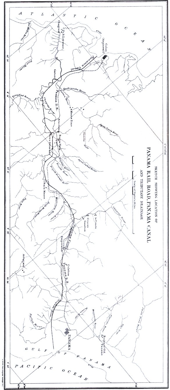

PROFILE OF THE PANAMA CANAL. Black indicates work executed; stipple, work to be executed to complete a lock-canal; white, additional work to be executed to complete a sea-level canal.
The first surveys for the railroad were made in 1849, and it was probably the excitement of the California gold fever that brought about its construction at this particular time. Ground was broken in January, 1850, and the last rail was laid in January, 1855.
The length of the road is 47.6 miles and it crosses the dividing summit at an elevation of 263 feet above the mean level of the Atlantic ocean. The maximum grade is 60 feet to the mile. Soon after the road was built accurate levels were run to determine the difference, if any, between the Atlantic and Pacific oceans, and it was found that the mean levels were about the same, although there are of course variations owing to local causes, and considerable differences of height at times, owing to differences of tides in the Atlantic and Pacific. At Aspinwall the greatest rise is only 1.6 feet, while at Panama there is at times a difference of over 21 feet between high and low water. The cost of the railroad was $75,000,000.
The existence of the railroad was probably the deciding cause that led Lesseps to the adoption of this location of the proposed canal.
Now that the scheme has practically failed it is very easy to see and appreciate the difficulties that lay in the way of building a canal at this particular place; and it certainly seems that if sound engineering principles had been adopted at least some of these difficulties could have been understood and properly combatted. The whole scheme, however, from an engineering standpoint, seems to have been conducted in the most blundering manner.
Lesseps is a diplomat and financier, but in no sense a great engineer. In the construction of the Suez canal, the questions of diplomacy and finance were the most difficult to settle, while the engineering problems were comparatively simple. In Panama the opposite conditions prevailed. Concessions were freely given him by the Colombian government and money freely offered him by the French people, but he never grasped or comprehended the difficulties that nature had planted in his way, and these only seemed to occur to him when they blocked progress in a certain direction. The Paris Conference, controlled by Lesseps, decided on the 29th of May, 1879, that the construction of an interoceanic canal was possible and that it should be built from the Gulf of Limon to the Bay of Panama.
The tide-level scheme was adopted and the following dimensions decided upon, viz: Length, 45.5 miles; depth, 28 feet; width at water line 164 feet, and width at bottom 72 feet.
The route determined upon was about the same as that of the railroad, that is along the valleys of the Chagres and Obispo, crossing the divide at the Culebra pass and then descending to the Pacific along the course of the Rio Grande. The profile which is reproduced from "Science," shows the state of progress on January 1st, 1888, and the amount of excavation that has been done since that time would make but a slight difference in the appearance of the profile. The portion shown in black is what has been removed along the axis of the canal and represents an expenditure of over $385,000,000 and seven years' labor. The reasons that make the scheme impracticable are briefly these, some of which were known before the work was commenced, and all of which should have been understood.
The first great difficulty is in cutting through the ridge culminating at Culebra where the original surface was 354 feet above the bed of the proposed canal. It was never known what the geological formation of this ridge was until the different strata were laid bare by the workman's pick, and the slope adopted, 1½ to 1, was found to be insufficient in the less compact formations, even at the comparatively shallow depth that was reached, and many and serious landslides were of frequent occurrence.
Another serious difficulty was the disposition of the excavated material, for upon the completion of a sea-level course this channel would naturally drain all the country hitherto tributary to the Chagres and Rio Grande, and any substance not removed to a great distance would eventually be washed back again into the canal. But perhaps the greatest difficulty was in the control of the immense surface drainage. The Chagres river during the dry season is, where it crosses the line of the canal near Gamboa, only about two feet deep and 250 feet wide, but during a flood the depth becomes as much as forty feet, the width 1,500 feet, and the volume of water discharged 160,000 cubic feet per second. The bed of the river is here 42 feet above sea level, or 70 feet above what the bottom of canal would have been. Now add to this a 40-foot flood and we have a water surface one hundred and ten feet above the bed of the canal.
In order to keep this immense volume of water from the canal it was proposed to build a large dam at Gamboa, and to convey the water by an entirely different and artificial route to the Atlantic. It is impossible to show on the map the whole drainage area of the Chagres, but a rough calculation shows it to be about 500 square miles. This seems a small total drainage area, but when it is considered that the annual rainfall is about 12 FEET, that this rainfall is confined to about one half the year, and that in six consecutive hours there has been a precipitation of over six inches of rain, some idea of the amount of water that finds its way through the Chagres river during the wet season may be formed.
As I said before it was proposed to protect the canal from the waters of the upper Chagres by an immense dam at Gamboa, and for the purpose of controlling the water tributary to the lower Chagres two additional canals or channels were to be constructed on either side of the main canal. Thus, as the river is very tortuous and the axis of the canal crossed it twenty-five or thirty times, many deviations of the former became necessary. In some places the canal was to occupy the bed of the river and in others it cut across bends leaving the river for its original natural purpose of drainage. The difficulty in retaining the floods in these constructed channels would of course be immense, especially in some of the cases where the water rushing along its natural channel is suddenly turned at right angles into an artificial one. Thus it is clear that aside from the enormous expense incident to the removal of the immense amount of earth and rock necessary to complete the canal, that granting all this accomplished, it would be practically impossible to maintain a sea-level canal by reason of the difficulty in controlling the Chagres and preventing the canal from filling up.
The canal company finally came to the conclusion that the sea-level scheme was impracticable and it was abandoned, and plans were prepared for a lock system. As seen on the profile there were ten locks proposed, five on each side of the summit level. The summit level was to be 150 feet above sea level and consequently each lock would have a lift of thirty feet. The profile was constructed especially to show the amount remaining to be executed to complete the lock system, and a mere inspection will show the relative amount of completed and uncompleted area along the axis of the canal. To complete the summit cut it is still necessary to excavate 111 feet, 93 feet having already been excavated, through a horizontal distance of 3300 feet. The width of cut at top surface for the required depth at a slope of 1½ to 1 would be 750 feet, but as I said before, at this slope landslides were of frequent occurrence and the slope would probably have to be increased to at least 2 to 1.
Granting the necessary excavations made, there would be still the problem of the control of the Chagres river and the water supply for the summit level to provide for. At first it was thought that the water supply could be obtained from the storage of the waters of the Chagres and Obispo, but this idea was eventually abandoned, either from a belief in the insufficiency of the water supply during the dry season, or from difficulties in the way of conveying the water to the summit level.
Then it was that the advice of Mr. Eiffel, a noted French engineer, was sought, and after a visit to the Isthmus he proposed that the summit level should be supplied by pumping from the Pacific. A contract was immediately made with Eiffel, who was heralded all over the world as the man who would save the canal, and immediately a positive day, the seventh that had been announced, was fixed for the opening of the great canal.
I do not know just how much work was done towards perfecting the system for pumping, but probably very little was ever accomplished in this direction, as soon after this scheme was thought of the available funds of the canal company began to be very scarce, and there has been since then a general collapse of work all along the line until now it is entirely suspended. From what I have said and from what can be seen from the profile, it will be readily understood that as far as the sea-level project is concerned the amount done is not much more than a scraping of the surface, relatively speaking, and that what has been done is in places where the obstacles were fewest.
In regard to the lock canal about one third of the necessary excavation has been made along the axis of the canal, but taking into consideration other requirements necessary for the completion of the scheme, I should estimate, roughly, that probably only one sixth of the whole amount of work had been accomplished. The question now naturally arises as to what will be the probable future of this great enterprise.
The French people have seen the scheme fail under Lesseps in whom they had the most unbounded confidence, and it is not likely that they will raise any more money to be put in it as a business enterprise under any other management. Saddled as it is with a debt of nearly four hundred millions of dollars, it would be difficult to convince any one that it could ever prove to be a paying investment. Nor do I think that any American or English corporation can be organized that could obtain such concessions from Lesseps as would make the scheme an inviting field for capitalists, and thus my opinion is that the "Compagnie Universelle du Canal Interocéanique de Panama" has irretrievably collapsed, and that the canal will remain, as it is now, the most gigantic failure of the age.
ACROSS NICARAGUA WITH TRANSIT AND MACHÉTE.
BY R. E. PEARY.
The action of this National Society, with its array of distinguished members, in turning its attention for an hour to a region which has interested the thinking world for more than three centuries gives me peculiar pleasure and satisfaction.
I propose this evening to touch lightly and briefly upon the natural features of Nicaragua, to note the reasons for the interest which has always centered upon her, to trace the growth of the great project with which her name is inseparably linked; to show you somewhat in detail, the life, work, and surroundings of an engineer within her borders; and finally to show you the result that is to crown the engineer's work in her wide spreading forests and fertile valleys.
That portion of Central America now included within the boundaries of our sister republic Nicaragua, has almost from the moment that European eyes looked upon it attracted and charmed the attention of explorers, geographers, great rulers, students, and men of sagacious and far reaching intellect.
From Gomara the long list of famous names which have linked themselves with Nicaragua reaches down through Humboldt, Napoleon III., Ammen, Lull, Menocal and Taylor.
The shores were first seen by Europeans in 1502, when Columbus in his fourth voyage rounded the cape which forms the northeast angle of the state, and called it "Gracias á Dios," which name it bears to-day. Columbus then coasted southward along the eastern shore.