NATIONAL GEOGRAPHIC MAGAZINE.
Reading edition
Vol. I. 1889. No. 3.
THE RIVERS AND VALLEYS OF PENNSYLVANIA.1
BY WILLIAM MORRIS DAVIS.
"In Faltensystemen von sehr hohem Alter wurde die ursprüngliche Anordnung der Langenthäler durch das Ueberhandnehmen der transversalen Erosionsfurchen oft ganz und gar verwischt."
LÖWL. Petermann's Mittheilungen, xxviii, 1882, 411.
1 The substance of this essay was presented to the Society in a lecture on February 8th, 1889, but since then it has been much expanded.
CONTENTS.
PART FIRST. Introductory. 1. Plan of work here proposed. 2. General description of the topography of Pennsylvania. 3. The drainage of Pennsylvania. 4. Previous studies of Appalachian drainage.
PART SECOND. Outline of the geological history of the region. 5. Conditions of formation. 6. Former extension of strata to the southeast. 7. Cambro-Silurian and Permian deformations. 8. Perm-Triassic denudation. 9. Newark deposition. 10. Jurassic tilting. 11. Jura-Cretaceous denudation. 12. Tertiary elevation and denudation. 13. Later changes of level. 14. Illustrations of Pennsylvanian topography.
PART THIRD. General conception of the history of a river. 15. The complete cycle of river life: youth, adolescence, maturity and old age. 16. Mutual adjustment of river courses. 17. Terminology of rivers changed by adjustment. 18. Examples of adjustments. 19. Revival of rivers by elevation and drowning by depression. 20. Opportunity for new adjustments with revival. 21. Antecedent and superimposed rivers. 22. Simple, compound, composite and complex rivers.
PART FOURTH. The development of the rivers of Pennsylvania. 23. Means of distinguishing between antecedent and adjusted consequent rivers. 24. Postulates of the argument. 25. Constructional Permian topography and consequent drainage. 26. The Jura mountains homologous with the Permian Alleghanies. 27. Development and adjustment of the Permian drainage. 28. Lateral water-gaps near the apex of synclinal ridges. 29. Departure of the Juniata from the Juniata-Catawissa syncline. 30. Avoidance of the Broad Top basin by the Juniata headwaters. 31. Reversal of larger rivers to southeast courses. 32. Capture of the Anthracite headwaters by the growing Susquehanna. 33. Present outward drainage of the Anthracite basins. 34. Homologies of the Susquehanna and Juniata. 35. Superimposition of the Susquehanna on two synclinal ridges. 36. Evidence of superimposition in the Susquehanna tributaries. 37. Events of the Tertiary cycle. 38. Tertiary adjustment of the Juniata on the Medina anticlines. 39. Migration of the Atlantic-Ohio divide. 40. Other examples of adjustments. 41. Events of the Quaternary cycle. 42. Doubtful cases. 43. Complicated history of our actual rivers. 44. Provisional conclusions.
PART FIRST. Introductory.
1. Plan of work here proposed.—No one now regards a river and its valley as ready-made features of the earth's surface. All are convinced that rivers have come to be what they are by slow processes of natural development, in which every peculiarity of river-course and valley-form has its appropriate cause. Being fully persuaded of the gradual and systematic evolution of topographic forms, it is now desired, in studying the rivers and valleys of Pennsylvania, to seek the causes of the location of the streams in their present courses; to go back if possible to the early date when central Pennsylvania was first raised above the sea and trace the development of the several river systems then implanted upon it from their ancient beginning to the present time.
The existing topography and drainage system of the State will first be briefly described. We must next inquire into the geological structure of the region, follow at least in a general way the deformations and changes of attitude and altitude that it has suffered, and consider the amount of denudation that has been accomplished on its surface. We must at the same time bear in mind the natural history of rivers, their morphology and development; we must recognize the varying activities of a river in its youth and old age, the adjustments of its adolescence and maturity, and the revival of its decrepit powers when the land that it drains is elevated and it enters a new cycle of life. Finally we shall attempt to follow out the development of the rivers of Pennsylvania by applying the general principles of river history to the special case of Pennsylvania structure.
2. General description of the topography of Pennsylvania.—The strongly marked topographic districts of Pennsylvania can hardly be better described than by quoting the account given over a century ago by Lewis Evans, of Philadelphia, in his "Analysis of a map of the middle British colonies in America" (1755), which is as valuable from its appreciative perception as it is interesting from its early date. The following paragraphs are selected from his early pages:
"The land southwestward of Hudson's River is more regularly divided and into a greater number of stages than the other. The first object worthy of regard in this part is a rief or vein of rocks of the talky or isinglassy kind, some two or three or half a dozen miles broad; rising generally some small matter higher than the adjoining land; and extending from New York city southwesterly by the lower falls of Delaware, Schuylkill, Susquehanna, Gun-Powder, Patapsco, Potomack, Rapahannock, James river and Ronoak. This was the antient maritime boundary of America and forms a very regular curve. The land between this rief and the sea and from the Navesink hills southwest ... may be denominated the Lower Plains, and consists of soil washt down from above and sand accumulated from the ocean. Where these plains are not penetrated by rivers, they are a white sea-sand, about twenty feet deep and perfectly barren, as no mixture of soil helps to enrich them. But the borders of the rivers, which descend from the uplands, are rendered fertile by the soil washt down with the floods and mixt with the sands gathered from the sea. The substratum of sea-mud, shells and other foreign subjects is a perfect confirmation of this supposition. And hence it is that for 40 or 50 miles inland and all the way from the Navesinks to Cape Florida, all is a perfect barren where the wash from the uplands has not enriched the borders of the rivers; or some ponds and defiles have not furnished proper support for the growth of white cedars....
"From this rief of rocks, over which all the rivers fall, to that chain of broken hills, called the South mountain, there is the distance of 50, 60 or 70 miles of very uneven ground, rising sensibly as you advance further inland, and may be denominated the Upland. This consists of veins of different kinds of soil and substrata some scores of miles in length; and in some places overlaid with little ridges and chains of hills. The declivity of the whole gives great rapidity to the streams; and our violent gusts of rain have washt it all into gullies, and carried down the soil to enrich the borders of the rivers in the Lower Plains. These inequalities render half the country not easily capable of culture, and impoverishes it, where torn up by the plow, by daily washing away the richer mould that covers the surface.
"The South mountain is not in ridges like the Endless mountains, but in small, broken, steep, stoney hills; nor does it run with so much regularity. In some places it gradually degenerates to nothing, not to appear again for some miles, and in others it spreads several miles in breadth. Between South mountain and the hither chain of the Endless mountains (often for distinction called the North mountain, and in some places the Kittatinni and Pequélin), there is a valley of pretty even good land, some 8, 10 or 20 miles wide, and is the most considerable quantity of valuable land that the English are possest of; and runs through New Jersey, Pensilvania, Mariland and Virginia. It has yet obtained no general name, but may properly enough be called Piemont, from its situation. Besides conveniences always attending good land, this valley is everywhere enriched with Limestone.
"The Endless mountains, so called from a translation of the Indian name bearing that signification, come next in order. They are not confusedly scattered and in lofty peaks overtopping one another, but stretch in long uniform ridges scarce half a mile perpendicular in any place above the intermediate vallies. Their name is expressive of their extent, though no doubt not in a literal sense.... The mountains are almost all so many ridges with even tops and nearly of a height. To look from these hills into the lower lands is but, as it were, into an ocean of woods, swelled and deprest here and there by little inequalities, not to be distinguished one part from another any more than the waves of the real ocean. The uniformity of these mountains, though debarring us of an advantage in this respect, makes some amends in another. They are very regular in their courses, and confine the creeks and rivers that run between; and if we know where the gaps are that let through these streams, we are not at a loss to lay down their most considerable inflections....
"To the northwestward of the Endless mountains is a country of vast extent, and in a manner as high as the mountains themselves. To look at the abrupt termination of it, near the sea level, as is the case on the west side of Hudson's river below Albany, it looks as a vast high mountain; for the Kaats Kills, though of more lofty stature than any other mountains in these parts of America, are but the continuation of the Plains on the top, and the cliffs of them in the front they present towards Kinderhook. These Upper Plains are of extraordinary rich level land, and extend from the Mohocks river through the country of the Confederates.2 Their termination northward is at a little distance from Lake Ontario; but what it is westward is not known, for those most extensive plains of Ohio are part of them."
2 Referring to the league of Indian tribes, so-called.
These several districts recognized by Evans may be summarized as the coastal plain, of nearly horizontal Cretaceous and later beds, just entering the southeastern corner of Pennsylvania; the marginal upland of contorted schists of disputed age; the South Mountain belt of ancient and much disturbed crystalline rocks, commonly called Archean; a space between these two traversed by the sandstone lowland of the Newark formation;3 the great Appalachian valley of crowded Cambrian limestones and slates; the region of the even-crested, linear Paleozoic ridges, bounded by Kittatinny or Blue mountain on the southeast and by Alleghany mountain on the northwest, this being the area with which we are here most concerned; and finally the Alleghany plateau, consisting of nearly horizontal Devonian and Carboniferous beds and embracing all the western part of the state. The whole region presents the most emphatic expression not only of its structure but also of the more recent cycles of development through which it has passed. Fig. 1 represents the stronger ridges and larger streams of the greater part of the central district: it is reproduced from the expressive Topographic Map of Pennsylvania (1871) by Lesley. The Susquehanna flows down the middle, receiving the West Branch from Lock Haven and Williamsport, the East Branch from Wilkes-Barre in the Wyoming basin, and the Juniata from the Broad Top region, south of Huntingdon. The Anthracite basins lie on the right, enclosed by zigzag ridges of Pocono and Pottsville sandstone; the Plateau, trenched by the West Branch of the Susquehanna is in the northwest. Medina sandstone forms most of the central ridges.
3 Russell has lately recommended the revival of this term, proposed many years ago by Redfield, as a non-committal name for the "New red sandstones" of our Atlantic slope, commonly called Triassic.
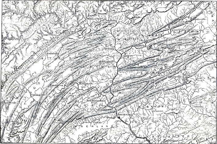
FIG. 1. Part of Topographic Map of Pennsylvania, by J. P. Lesley (1871).
3. The drainage of Pennsylvania.—The greater part of the Alleghany plateau is drained westward into the Ohio, and with this we shall have little to do. The remainder of the plateau drainage reaches the Atlantic by two rivers, the Delaware and the Susquehanna, of which the latter is the more special object of our study. The North and West Branches of the Susquehanna rise in the plateau, which they traverse in deep valleys; thence they enter the district of the central ranges, where they unite and flow in broad lowlands among the even-crested ridges. The Juniata brings the drainage of the Broad Top region to the main stream just before their confluent current cuts across the marginal Blue Mountain. The rock-rimmed basins of the anthracite region are drained by small branches of the Susquehanna northward and westward, and by the Schuylkill and Lehigh to the south and east. The Delaware, which traverses the plateau between the Anthracite region and the Catskill Mountain front, together with the Lehigh, the Schuylkill, the little Swatara and the Susquehanna, cut the Blue Mountain by fine water-gaps, and cross the great limestone valley. The Lehigh then turns eastward and joins the Delaware, and the Swatara turns westward to the Susquehanna; but the Delaware, Schuylkill and Susquehanna all continue across South Mountain and the Newark belt, and into the low plateau of schists beyond. The Schuylkill unites with the Delaware near Philadelphia, just below the inner margin of the coastal plain; the Delaware and the Susquehanna continue in their deflected estuaries to the sea. All of these rivers and many of their side streams are at present sunk in small valleys of moderate depth and width, below the general surface of the lowlands, and are more or less complicated with terrace gravels.
4. Previous studies of Appalachian drainage.—There have been no special studies of the history of the rivers of Pennsylvania in the light of what is now known of river development. A few recent essays of rather general character as far as our rivers are concerned, may be mentioned.
Peschel examined our rivers chiefly by means of general maps with little regard to the structure and complicated history of the region. He concluded that the several transverse rivers which break through the mountains, namely, the Delaware, Susquehanna and Potomac, are guided by fractures, anterior to the origin of the rivers.4 There does not seem to be sufficient evidence to support this obsolescent view, for most of the water-gaps are located independently of fractures; nor can Peschel's method of river study be trusted as leading to safe conclusions.
4 Physische Erdkunde, 1880, ii, 442.
Tietze regards our transverse valleys as antecedent;5 but this was made only as a general suggestion, for his examination of the structure and development of the region is too brief to establish this and exclude other views.
5 Jahrbuch Geol. Reichsanstalt, xxviii, 1878, 600.
Löwl questions the conclusion reached by Tietze and ascribes the transverse gaps to the backward or headwater erosion of external streams, a process which he has done much to bring into its present important position, and which for him replaces the persistence of antecedent streams of other authors.6
6 Pet. Mitth., 1882, 405; Ueber Thalbildung, Prag, 1884.
A brief article7 that I wrote in comment on Löwl's first essay several years ago now seems to me insufficient in its method. It exaggerated the importance of antecedent streams; it took no sufficient account of the several cycles of erosion through which the region has certainly passed; and it neglected due consideration of the readjustment of initial immature stream courses during more advanced river-life. Since then, a few words in Löwl's essay have come to have more and more significance to me; he says that in mountain systems of very great age, the original arrangement of the longitudinal valleys often becomes entirely confused by means of their conquest by transverse erosion gaps. This suggestion has been so profitable to me that I have placed the original sentence at the beginning of this paper. Its thesis is the essential element of my present study.
7 Origin of Cross-valleys. Science, i, 1883, 325.
Phillipson refers to the above-mentioned authors and gives a brief account of the arrangement of drainage areas within our Appalachians, but briefly dismisses the subject.8 His essay contains a serviceable bibliography.
8 Studien über Wasserscheiden. Leipsig, 1886, 149.
If these several earlier essays have not reached any precise conclusion, it may perhaps be because the details of the geological structure and development of Pennsylvania have not been sufficiently examined. Indeed, unless the reader has already become familiar with the geological maps and reports of the Pennsylvania surveys and is somewhat acquainted with its geography, I shall hardly hope to make my case clear to him. The volumes that should be most carefully studied are, first, the always inspiring classic, "Coal and its Topography" (1856), by Lesley, in which the immediate relation of our topography to the underlying structure is so finely described; the Geological Map of Pennsylvania (1856), the result of the labors of the first survey of the state; and the Geological Atlas of Counties, Volume X of the second survey (1885). Besides these, the ponderous volumes of the final report of the first survey and numerous reports on separate counties by the second survey should be examined, as they contain many accounts of the topography although saying very little about its development. If, in addition to all this, the reader has seen the central district of the state and marvelled at its even-crested, straight and zigzag ridges, and walked through its narrow water-gaps into the enclosed coves that they drain, he may then still better follow the considerations here presented.
PART SECOND. Outline of the geological history of the region.
5. Conditions of formation.—The region in which the Susquehanna and the neighboring rivers are now located is built in chief part of marine sediments derived in paleozoic time from a large land area to the southeast, whose northwest coast-line probably crossed Pennsylvania somewhere in the southeastern part of the state; doubtless varying its position, however, by many miles as the sea advanced and receded in accordance with the changes in the relative altitudes of the land and water surfaces, such as have been discussed by Newberry and Claypole. The sediments thus accumulated are of enormous thickness, measuring twenty or thirty thousand feet from their crystalline foundation to the uppermost layer now remaining. The whole mass is essentially conformable in the central part of the state. Some of the formations are resistent, and these have determined the position of our ridges; others are weaker and are chosen as the sites of valleys and lowlands. The first are the Oneida and Medina sandstones, which will be here generally referred to under the latter name alone, the Pocono sandstone and the Pottsville conglomerate; to these may be added the fundamental crystalline mass on which the whole series of bedded formations was deposited, and the basal sandstone that is generally associated with it. Wherever we now see these harder rocks, they rise above the surrounding lowland surface. On the other hand, the weaker beds are the Cambrian limestones (Trenton) and slates (Hudson River), all the Silurian except the Medina above named, the whole of the Devonian—in which however there are two hard beds of subordinate value, the Oriskany sandstone and a Chemung sandstone and conglomerate, that form low and broken ridges over the softer ground on either side of them—and the Carboniferous (Mauch Chunk) red shales and some of the weaker sandstones (Coal measures).
6. Former extension of strata to the southeast.—We are not much concerned with the conditions under which this great series of beds was formed; but, as will appear later, it is important for us to recognize that the present southeastern margin of the beds is not by any means their original margin in that direction. It is probable that the whole mass of deposits, with greater or less variations of thickness, extended at least twenty miles southeast of Blue Mountain, and that many of the beds extended much farther. The reason for this conclusion is a simple one. The several resistant beds above-mentioned consist of quartz sand and pebbles that cannot be derived from the underlying beds of limestones and shales; their only known source lay in the crystalline rocks of the paleozoic land to the southeast. South Mountain may possibly have made part of this paleozoic land; but it seems more probable that it was land only during the earlier Archean age, and that it was submerged and buried in Cambrian time and not again brought to the light of day until it had been crushed into many local anticlines9 whose crests were uncovered by Permian and later erosion. The occurrence of Cambrian limestone on either side of South Mountain, taken with its compound anticlinal structure, makes it likely that Medina time found this crystalline area entirely covered by the Cambrian beds; Medina sands must therefore have come from farther still to the southeast. A similar argument applies to the source of the Pocono and Pottsville beds. The measure of twenty miles as the former southeastern extension of the paleozoic formations therefore seems to be a moderate one for the average of the whole series; perhaps forty would be nearer the truth.
9 Lesley, as below.
7. Cambro-Silurian and Permian deformations.—This great series of once horizontal beds is now wonderfully distorted; but the distortions follow a general rule of trending northeast and southwest, and of diminishing in intensity from southeast to northwest. In the Hudson Valley, it is well known that a considerable disturbance occurred between Cambrian and Silurian time, for there the Medina lies unconformably on the Hudson River shales. It seems likely, for reasons that will be briefly given later on, that the same disturbance extended into Pennsylvania and farther southwest, but that it affected only the southeastern corner of the State; and that the unconformities in evidence of it, which are preserved in the Hudson Valley, are here lost by subsequent erosion. Waste of the ancient land and its Cambro-Silurian annex still continued and furnished vast beds of sandstone and sandy shales to the remaining marine area, until at last the subsiding Paleozoic basin was filled up and the coal marshes extended broadly across it. At this time we may picture the drainage of the southeastern land area wandering rather slowly across the great Carboniferous plains to the still submerged basin far to the west; a condition of things that is not imperfectly represented, although in a somewhat more advanced stage, by the existing drainage of the mountains of the Carolinas across the more modern coastal plain to the Atlantic.
This condition was interrupted by the great Permian deformation that gave rise to the main ranges of the Appalachians in Pennsylvania, Virginia and Tennessee. The Permian name seems appropriate here, for while the deformation may have begun at an earlier date, and may have continued into Triassic time, its culmination seems to have been within Permian limits. It was characterized by a resistless force of compression, exerted in a southeast-northwest line, in obedience to which the whole series of Paleozoic beds, even twenty or more thousand feet in thickness, was crowded gradually into great and small folds, trending northeast and southwest. The subjacent Archean terrane doubtless shared more or less in the disturbance: for example, South Mountain is described by Lesley as "not one mountain, but a system of mountains separated by valleys. It is, geologically considered, a system of anticlinals with troughs between.... It appears that the South Mountain range ends eastward [in Cumberland and York Counties] in a hand with five [anticlinal] fingers."10
10 Proc. Amer. Phil. Soc., xiii, 1873, 6.
It may be concluded with fair probability that the folds began to rise in the southeast, where they are crowded closest together, some of them having begun here while coal marshes were still forming farther west; and that the last folds to be begun were the fainter ones on the plateau, now seen in Negro mountain and Chestnut and Laurel ridges. In consequence of the inequalities in the force of compression or in the resistance of the yielding mass, the folds do not continue indefinitely with horizontal axes, but vary in height, rising or falling away in great variety. Several adjacent folds often follow some general control in this respect, their axes rising and falling together. It is to an unequal yielding of this kind that we owe the location of the Anthracite synclinal basins in eastern Pennsylvania, the Coal Measures being now worn away from the prolongation of the synclines, which rise in either direction.
8. Perm-Triassic denudation.—During and for a long time after this period of mountain growth, the destructive processes of erosion wasted the land and lowered its surface. An enormous amount of material was thus swept away and laid down in some unknown ocean bed. We shall speak of this as the Perm-Triassic period of erosion. A measure of its vast accomplishment is seen when we find that the Newark formation, which is generally correlated with Triassic or Jurassic time, lies unconformably on the eroded surface of Cambrian and Archean rocks in the southeastern part of the State, where we have concluded that the Paleozoic series once existed; where the strata must have risen in a great mountain mass as a result of the Appalachian deformations; and whence they must therefore have been denuded before the deposition of the Newark beds. Not only so; the moderate sinuosity of the southeastern or under boundary of the Newark formation indicates clearly enough that the surface on which that portion of the formation lies is one of no great relief or inequality; and such a surface can be carved out of an elevated land only after long continued denudation, by which topographic development is carried beyond the time of its greatest strength or maturity into the fainter expression of old age. This is a matter of some importance in our study of the development of the rivers of Pennsylvania; and it also constitutes a good part of the evidence already referred to as indicating that there must have been some earlier deformations of importance in the southeastern part of the State; for it is hardly conceivable that the great Paleozoic mass could have been so deeply worn off of the Newark belt between the making of the last of the coal beds and the first of the Newark. It seems more in accordance with the facts here recounted and with the teachings of geological history in general to suppose, as we have here, that something of the present deformation of the ancient rocks underlying the Newark beds was given at an early date, such as that of the Green Mountain growth; and that a certain amount of the erosion of the folded beds was thus made possible in middle Paleozoic time; then again at some later date, as Permian, a second period of mountain growth arrived, and further folding was effected, and after this came deeper erosion; thus dividing the destructive work that was done into several parts, instead of crowding it all into the post-Carboniferous time ordinarily assigned to it. It is indeed not impossible that an important share of what we have called the Permian deformation was, as above suggested, accomplished in the southeastern part of the State while the coal beds were yet forming in the west; many grains of sand in the sandstones of the Coal Measures may have had several temporary halts in other sandstone beds between the time of their first erosion from the Archean rocks and the much later time when they found the resting place that they now occupy.11
11 These considerations may have value in showing that the time in which the lateral crushing of the Appalachians was accomplished was not so brief as is stated by Reade in a recent article in the American Geologist, iii, 1889, 106.
9. Newark deposition.—After the great Paleozoic and Perm-Triassic erosions thus indicated, when the southeastern area of ancient mountains had been well worn down and the Permian folds of the central district had acquired a well developed drainage, there appeared an opportunity for local deposition in the slow depression of a northeast-southwest belt of the deeply wasted land, across the southeastern part of the State; and into this trough-like depression, the waste from the adjacent areas on either side was carried, building the Newark formation. This may be referred to as the Newark or Trias-Jurassic period of deposition. The volume of this formation is unknown, as its thickness and original area are still undetermined; but it is pretty surely of many thousand feet in vertical measure, and its original area may have been easily a fifth or a quarter in excess of its present area, if not larger yet. So great a local accumulation seems to indicate that while the belt of deposition was sinking, the adjacent areas were rising, in order to furnish a continual supply of material; the occurrence of heavy conglomerates along the margins of the Newark formation confirms this supposition, and the heavy breccias near Reading indicate the occurrence of a strong topography and a strong transporting agent to the northwest of this part of the Newark belt. It will be necessary, when the development of the ancestors of our present rivers is taken up, to consider the effects of the depression that determined the locus of Newark deposition and of the adjacent elevation that maintained a supply of material.
10. Jurassic tilting.—Newark deposition was stopped by a gradual reversal of the conditions that introduced it. The depression of the Newark belt was after a time reversed into elevation, accompanied by a peculiar tilting, and again the waste of the region was carried away to some unknown resting place. This disturbance, which may be regarded as a revival of the Permian activity, culminated in Jurassic, or at least in post-Newark time, and resulted in the production of the singular monoclinal attitude of the formation; and as far as I can correlate it with the accompanying change in the underlying structures, it involved there an over-pushing of the closed folds of the Archean and Paleozoic rocks. This is illustrated in figs. 2 and 3, in which the original and disturbed attitudes of the Newark and the underlying formations are roughly shown, the over-pushing of the fundamental folds causing the monoclinal and probably faulted structure in the overlying beds.12 If this be true, we might suspect that the unsymmetrical attitude of the Appalachian folds, noted by Rogers as a characteristic of the range, is a feature that was intensified if not originated in Jurassic and not in Permian time.
12 Amer. Journ. Science, xxxii, 1886, 342; and Seventh Ann. Rept. U. S. Geol. Survey, 1888, 486.
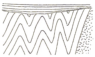
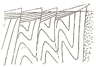
FIG. 2. FIG. 3.
It is not to be supposed that the Jurassic deformation was limited to the area of the Newark beds; it may have extended some way on either side; but it presumably faded out at no great distance, for it has not been detected in the history of the Atlantic and Mississippi regions remote from the Newark belt. In the district of the central folds of Pennsylvania, with which we are particularly concerned, this deformation was probably expressed in a further folding and over-pushing of the already partly folded beds, with rapidly decreasing effect to the northwest; and perhaps also by slip-faults, which at the surface of the ground nearly followed the bedding planes: but this is evidently hypothetical to a high degree. The essential point for our subsequent consideration is that the Jurassic deformation was probably accompanied by a moderate elevation, for it allowed the erosion of the Newark beds and of laterally adjacent areas as well.
11. Jura-Cretaceous denudation.—In consequence of this elevation, a new cycle of erosion was entered upon, which I shall call the Jura-Cretaceous cycle. It allowed the accomplishment of a vast work, which ended in the production of a general lowland of denudation, a wide area of faint relief, whose elevated remnants are now to be seen in the even ridge-crests that so strongly characterize the central district, as well as in certain other even uplands, now etched by the erosion of a later cycle of destructive work. I shall not here take space for the deliberate statement of the argument leading to this end, but its elements are as follows: the extraordinarily persistent accordance among the crest-line altitudes of many Medina and Carboniferous ridges in the central district; the generally corresponding elevation of the western plateau surface, itself a surface of erosion, but now trenched by relatively deep and narrow valleys; the generally uniform and consistent altitude of the uplands in the crystalline highlands of northern New Jersey and in the South Mountains of Pennsylvania; and the extension of the same general surface, descending slowly eastward, over the even crest-lines of the Newark trap ridges. Besides the evidence of less continental elevation thus deduced from the topography, it may be noted that a lower stand of the land in Cretaceous time than now is indicated by the erosion that the Cretaceous beds have suffered in consequence of the elevation that followed their deposition. The Cretaceous transgression in the western states doubtless bears on the problem also. Finally it may be fairly urged that it is more accordant with what is known about old mountains in general to suppose that their mass has stood at different attitudes with respect to base level during their long period of denudation than to suppose that they have held one attitude through all the time since their deformation.
It is natural enough that the former maintenance of some lower altitude than the present should have expression in the form of the country, if not now extinguished by subsequent erosion. It is simply the reverse of this statement that leads us to the above-stated conclusion. We may be sure that the long maintained period of relative quiet was of great importance in allowing time for the mature adjustment of the rivers of the region, and hence due account must be taken of it in a later section. I say relative quiet, for there were certainly subordinate oscillations of greater or less value; McGee has detected records of one of these about the beginning of Cretaceous time, but its effects are not now known to be of geographic value; that is, they do not now manifest themselves in the form of the present surface of the land, but only in the manner of deposition and ancient erosion of certain deposits.13 Another subordinate oscillation in the sense of a moderate depression seems to have extended through middle and later Cretaceous time, resulting in an inland transgression of the sea and the deposit of the Cretaceous formation unconformably on the previous land surface for a considerable distance beyond the present margin of the formation.14 This is important as affecting our rivers. Although these oscillations were of considerable geological value, I do not think that for the present purposes they call for any primary division of the Jura-Cretaceous cycle; for as the result of this long period of denudation we find but a single record in the great lowland of erosion above described, a record of prime importance in the geographic development of our region, that will often be referred to. The surface of faint relief then completed may be called the Cretaceous baselevel lowland. It may be pictured as a low, undulating plain of wide extent, with a portion of its Atlantic margin submerged and covered over with a relatively thin marine deposit of sands, marls and clays.
13 Amer. Jour. Science, xxxv, 1888, 367, 448.
14 This statement is based on a study of the geographic evolution of northern New Jersey, in preparation for publication.
12. Tertiary elevation and denudation.—This broad lowland is a lowland no longer. It has been raised over the greater part of its area into a highland, with an elevation of from one to three thousand feet, sloping gently eastward and descending under the Atlantic level near the present margin of the Cretaceous formation. The elevation seems to have taken place early in Tertiary time, and will be referred to as of that date. Opportunity was then given for the revival of the previously exhausted forces of denudation, and as a consequence we now see the formerly even surface of the plain greatly roughened by the incision of deep valleys and the opening of broad lowlands on its softer rocks. Only the harder rocks retain indications of the even surface which once stretched continuously across the whole area. The best indication of the average altitude at which the mass stood through the greater part of post-Cretaceous time is to be found on the weak shales of the Newark formation in New Jersey and Pennsylvania, and on the weak Cambrian limestones of the great Kittatinny valley; for both of these areas have been actually almost baselevelled again in the Tertiary cycle. They will be referred to as the Tertiary baselevel lowlands; and the valleys corresponding to them, cut in the harder rocks, as well as the rolling lowlands between the ridges of the central district of Pennsylvania will be regarded as of the same date. Whatever variations of level occurred in this cycle of development do not seem to have left marks of importance on the inland surface, though they may have had greater significance near the coast.
13. Later changes of level.—Again at the close of Tertiary time, there was an elevation of moderate amount, and to this may be referred the trenches that are so distinctly cut across the Tertiary baselevel lowland by the larger rivers, as well as the lateral shallower channels of the smaller streams. This will be called the Quaternary cycle; and for the present no further mention of the oscillations known to have occurred in this division of time need be considered; the reader may find careful discussion of them in the paper by McGee, above referred to. It is proper that I should add that the suggestion of baselevelling both of the crest-lines and of the lowlands, that I have found so profitable in this and other work, is due largely to personal conference with Messrs. Gilbert and McGee of the Geological Survey; but it is not desired to make them in any way responsible for the statements here given.
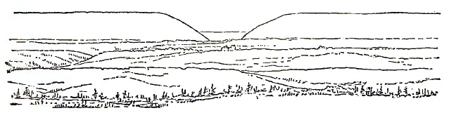
FIG. 4.
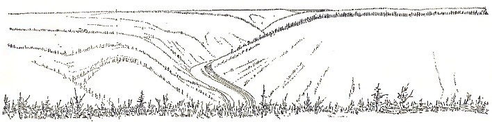
FIG. 5.
14. Illustrations of Pennsylvanian topography.—A few sketches made during a recent recess-trip with several students through Pennsylvania may be introduced in this connection. The first, fig. 4, is a view from Jenny Jump mountain, on the northwestern side of the New Jersey highlands, looking northwest across the Kittatinny valley-lowland to Blue or Kittatinny mountain, where it is cut at the Delaware Water-gap. The extraordinarily level crest of the mountain preserves record of the Cretaceous baselevel lowland; since the elevation of this ancient lowland, its softer rocks have, as it were, been etched out, leaving the harder ones in relief; thus the present valley-lowland is to be explained. In consequence of the still later elevation of less amount, the Delaware has cut a trench in the present lowland, which is partly seen to the left in the sketch. Fig. 5 is a general view of the Lehigh plateau and cañon, looking south from Bald Mountain just above Penn Haven Junction. Blue mountain is the most distant crest, seen for a little space. The ridges near and above Mauch Chunk form the other outlines; all rising to an astonishingly even altitude, in spite of their great diversity of structure. Before the existing valleys were excavated, the upland surface must have been an even plain—the Cretaceous baselevel lowland elevated into a plateau. The valleys cut into the plateau during the Tertiary cycle are narrow here, because the rocks are mostly hard. The steep slopes of the cañon-like valley of the Lehigh and the even crests of the ridges manifestly belong to different cycles of development. Figs. 6 and 7 are gaps cut in Black Log and Shade mountain, by a small upper branch stream of the Juniata in southeastern Huntingdon county. The stream traverses a breached anticlinal of Medina sandstone, of which these mountains are the lateral members. A long narrow valley is opened on the axial Trenton limestone between the two. The gaps are not opposite to each other, and therefore in looking through either gap from the outer country the even crest of the further ridge is seen beyond the axial valley. The gap in Black Log mountain, fig. 6, is located on a small fracture, but in this respect it is unlike most of its fellows.15 The striking similarity of the two views illustrates the uniformity that so strongly characterizes the Medina ridges of the central district. Fig. 8 is in good part an ideal view, based on sketches on the upper Susquehanna, and designed to present a typical illustration of the more significant features of the region. It shows the even crest-lines of a high Medina or Pocono ridge in the background, retaining the form given to it in the Cretaceous cycle; the even lowlands in the foreground, opened on the weaker Siluro-Devonian rocks in the Tertiary cycle; and the uneven ridges in the middle distance marking the Oriskany and Chemung beds of intermediate hardness that have lost the Cretaceous level and yet have not been reduced to the Tertiary lowland. The Susquehanna flows distinctly below the lowland plain, and the small side streams run in narrow trenches of late Tertiary and Quaternary date.
15 Second Geol. Surv. Pa., Report T3, 19.
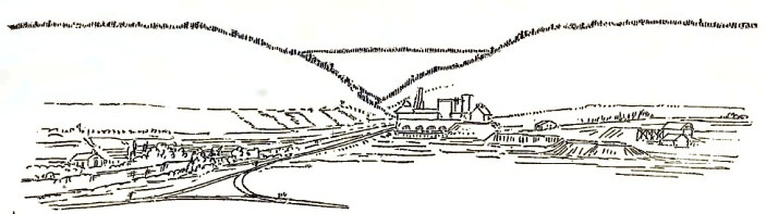
FIG. 6.
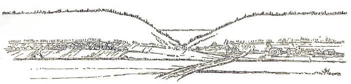
FIG. 7.
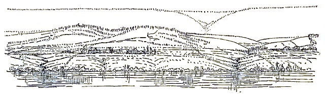
FIG. 8.
If this interpretation is accepted, and the Permian mountains are seen to have been once greatly reduced and at a later time worn out, while the ridges of to-day are merely the relief left by the etching of Tertiary valleys in a Cretaceous baselevelled lowland, then we may well conclude with Powell that "mountains cannot remain long as mountains; they are ephemeral topographic forms."16
16 Geol. Uinta Mountains, 1876, 196.
PART THIRD. General conception of the history of a river.
15. The complete cycle of river life: youth, adolescence, maturity and old age.—The general outline of an ideal river's history may be now considered, preparatory to examining the special history of the rivers of Pennsylvania, as controlled by the geological events just narrated.
Rivers are so long lived and survive with more or less modification so many changes in the attitude and even in the structure of the land, that the best way of entering on their discussion seems to be to examine the development of an ideal river of simple history, and from the general features thus discovered, it may then be possible to unravel the complex sequence of events that leads to the present condition of actual rivers of complicated history.
A river that is established on a new land may be called an original river. It must at first be of the kind known as a consequent river, for it has no ancestor from which to be derived. Examples of simple original rivers may be seen in young plains, of which southern New Jersey furnishes a fair illustration. Examples of essentially original rivers may be seen also in regions of recent and rapid displacement, such as the Jura or the broken country of southern Idaho, where the directly consequent character of the drainage leads us to conclude that, if any rivers occupied these regions before their recent deformation, they were so completely extinguished by the newly made slopes that we see nothing of them now.
Once established, an original river advances through its long life, manifesting certain peculiarities of youth, maturity and old age, by which its successive stages of growth may be recognized without much difficulty. For the sake of simplicity, let us suppose the land mass, on which an original river has begun its work, stands perfectly still after its first elevation or deformation, and so remains until the river has completed its task of carrying away all the mass of rocks that rise above its baselevel. This lapse of time will be called a cycle in the life of a river. A complete cycle is a long measure of time in regions of great elevation or of hard rocks; but whether or not any river ever passed through a single cycle of life without interruption we need not now inquire. Our purpose is only to learn what changes it would experience if it did thus develop steadily from infancy to old age without disturbance.
In its infancy, the river drains its basin imperfectly; for it is then embarrassed by the original inequalities of the surface, and lakes collect in all the depressions. At such time, the ratio of evaporation to rainfall is relatively large, and the ratio of transported land waste to rainfall is small. The channels followed by the streams that compose the river as a whole are narrow and shallow, and their number is small compared to that which will be developed at a later stage. The divides by which the side-streams are separated are poorly marked, and in level countries are surfaces of considerable area and not lines at all. It is only in the later maturity of a system that the divides are reduced to lines by the consumption of the softer rocks on either side. The difference between constructional forms and those forms that are due to the action of denuding forces is in a general way so easily recognized, that immaturity and maturity of a drainage area can be readily discriminated. In the truly infantile drainage system of the Red River of the North, the inter-stream areas are so absolutely flat that water collects on them in wet weather, not having either original structural slope or subsequently developed denuded slope to lead it to the streams. On the almost equally young lava blocks of southern Oregon, the well-marked slopes are as yet hardly channeled by the flow of rain down them, and the depressions among the tilted blocks are still undrained, unfilled basins.
As the river becomes adolescent, its channels are deepened and all the larger ones descend close to baselevel. If local contrasts of hardness allow a quick deepening of the down-stream part of the channel, while the part next up-stream resists erosion, a cascade or waterfall results; but like the lakes of earlier youth, it is evanescent, and endures but a small part of the whole cycle of growth; but the falls on the small headwater streams of a large river may last into its maturity, just as there are young twigs on the branches of a large tree. With the deepening of the channels, there comes an increase in the number of gulleys on the slopes of the channel; the gulleys grow into ravines and these into side valleys, joining their master streams at right angles (La Noë and Margerie). With their continued development, the maturity of the system is reached; it is marked by an almost complete acquisition of every part of the original constructional surface by erosion under the guidance of the streams, so that every drop of rain that falls finds a way prepared to lead it to a stream and then to the ocean, its goal. The lakes of initial imperfection have long since disappeared; the waterfalls of adolescence have been worn back, unless on the still young headwaters. With the increase of the number of side-streams, ramifying into all parts of the drainage basin, there is a proportionate increase in the surface of the valley slopes, and with this comes an increase in the rate of waste under atmospheric forces; hence it is at maturity that the river receives and carries the greatest load; indeed, the increase may be carried so far that the lower trunk-stream, of gentle slope in its early maturity, is unable to carry the load brought to it by the upper branches, and therefore resorts to the temporary expedient of laying it aside in a flood-plain. The level of the flood-plain is sometimes built up faster than the small side-streams of the lower course can fill their valleys, and hence they are converted for a little distance above their mouths into shallow lakes. The growth of the flood-plain also results in carrying the point of junction of tributaries farther and farther down stream, and at last in turning lateral streams aside from the main stream, sometimes forcing them to follow independent courses to the sea (Lombardini). But although thus separated from the main trunk, it would be no more rational to regard such streams as independent rivers than it would be to regard the branch of an old tree, now fallen to the ground in the decay of advancing age, as an independent plant; both are detached portions of a single individual, from which they have been separated in the normal processes of growth and decay.
In the later and quieter old age of a river system, the waste of the land is yielded slower by reason of the diminishing slopes of the valley sides; then the headwater streams deliver less detritus to the main channel, which, thus relieved, turns to its postponed task of carrying its former excess of load to the sea, and cuts terraces in its flood-plain, preparatory to sweeping it away. It does not always find the buried channel again, and perhaps settling down on a low spur a little to one side of its old line, produces a rapid or a low fall on the lower slope of such an obstruction (Penck). Such courses may be called locally superimposed.
It is only during maturity and for a time before and afterwards that the three divisions of a river, commonly recognized, appear most distinctly; the torrent portion being the still young headwater branches, growing by gnawing backwards at their sources; the valley portion proper, where longer time of work has enabled the valley to obtain a greater depth and width; and the lower flood-plain portion, where the temporary deposition of the excess of load is made until the activity of middle life is past.
Maturity seems to be a proper term to apply to this long enduring stage; for as in organic forms, where the term first came into use, it here also signifies the highest development of all functions between a youth of endeavor towards better work and an old age of relinquishment of fullest powers. It is the mature river in which the rainfall is best lead away to the sea, and which carries with it the greatest load of land waste; it is at maturity that the regular descent and steady flow of the river is best developed, being the least delayed in lakes and least overhurried in impetuous falls.
Maturity past, and the power of the river is on the decay. The relief of the land diminishes, for the streams no longer deepen their valleys although the hill tops are degraded; and with the general loss of elevation, there is a failure of rainfall to a certain extent; for it is well known that up to certain considerable altitudes rainfall increases with height. A hyetographic and a hypsometric map of a country for this reason show a marked correspondence. The slopes of the headwaters decrease and the valley sides widen so far that the land waste descends from them slower than before. Later, what with failure of rainfall and decrease of slope, there is perhaps a return to the early imperfection of drainage, and the number of side streams diminishes as branches fall from a dying tree. The flood-plains of maturity are carried down to the sea, and at last the river settles down to an old age of well-earned rest with gentle flow and light load, little work remaining to be done. The great task that the river entered upon is completed.
16. Mutual adjustment of river courses.—In certain structures, chiefly those of mountainous disorder on which the streams are at first high above baselevel, there is a process of adjustment extremely characteristic of quiet river development, by which the down-hill courses that were chosen in early life, and as we may say unadvisedly and with the heedlessness and little foresight of youth, are given up for others better fitted for the work of the mature river system. A change of this kind happens when the young stream taking the lowest line for its guide happens to flow on a hard bed at a considerable height above baselevel, while its branches on one side or the other have opened channels on softer beds: a part of the main channel may then be deserted by the withdrawal of its upper waters to a lower course by way of a side stream. The change to better adjustment also happens when the initial course of the main stream is much longer than a course that may be offered to its upper portion by the backward gnawing of an adjacent stream (Löwl, Penck). Sometimes the lateral cutting or planation that characterizes the main trunk of a mature river gives it possession of an adjacent smaller stream whose bed is at a higher level (Gilbert). A general account of these processes may be found in Phillippson's serviceable "Studien über Wasserscheiden" (Leipzig, 1886). This whole matter is of much importance and deserves deliberate examination. It should be remembered that changes in river courses of the kind now referred to are unconnected with any external disturbance of the river basin, and are purely normal spontaneous acts during advancing development. Two examples, pertinent to our special study, will be considered.
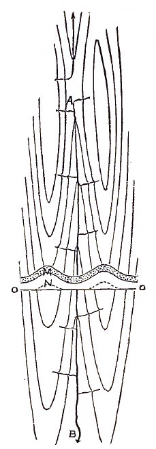
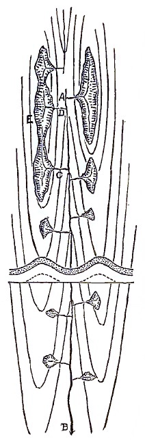
FIG. 9. FIG. 10.
Let AB, fig. 9, be a stream whose initial consequent course led it down the gently sloping axial trough of a syncline. The constructional surface of the syncline is shown by contours. Let the succession of beds to be discovered by erosion be indicated in a section, laid in proper position on the several diagrams, but revolved into the horizontal plane, the harder beds being dotted and the baselevel standing at OO. Small side streams will soon be developed on the slopes of the syncline, in positions determined by cross-fractures or more often by what we call accident; the action of streams in similar synclines on the outside of the enclosing anticlines will be omitted for the sake of simplicity. In time, the side streams will cut through the harder upper bed M and enter the softer bed N, on which longitudinal channels, indicated by hachures, will be extended along the strike, fig. 10 (La Noë and Margerie). Let these be called "subsequent" streams. Consider two side streams of this kind, C and D, heading against each other at E, one joining the main stream lower down the axis of the syncline than the other. The headwaters of C will rob the headwaters of D, because the deepening of the channel of D is retarded by its having to join the main stream at a point where the hard bed in the axis of the fold holds the main channel well above baselevel. The notch cut by D will then be changed from a water-gap to a wind-gap and the upper portion of D will find exit through the notch cut by C, as in fig. 11. As other subsequent headwaters make capture of C, the greater depth to which the lateral valley is cut on the soft rock causes a slow migration of the divides in the abandoned gaps towards the main stream, and before long the upper part of the main stream itself will be led out of the synclinal axis to follow the monoclinal valley at one side for a distance, fig. 12, until the axis can be rejoined through the gap where the axial portion of the controlling hard bed is near or at baselevel. The upper part of the synclinal trough will then be attacked by undercutting on the slope of the quickly deepened channels of the lateral streams, and the hard bed will be worn away in the higher part of the axis before it is consumed in the lower part. The location of the successful lateral stream on one or the other side of the syncline may be determined by the dip of the beds, gaps being cut quicker on steep than on gentle dips. If another hard bed is encountered below the soft one, the process will be repeated; and the mature arrangement of the streams will be as in fig. 13 (on a smaller scale than the preceding), running obliquely off the axis of the fold where a hard bed of the syncline rises above baselevel, and returning to the axis where the hard bed is below or at baselevel; a monoclinal stream wandering gradually from the axis along the strike of the soft bed, AE, by which the side-valley is located and returning abruptly to the axis by a cataclinal17 stream in a transverse gap, EB, in the next higher hard bed, and there rejoining the diminished representative or survivor of the original axial or synclinal stream, GB.
17 See the terminology suggested by Powell. Expl. Col. R. of the West, 1875, 160. This terminology is applicable only to the most detailed study of our rivers, by reason of their crossing so many folds, and changing so often from longitudinal to transverse courses.
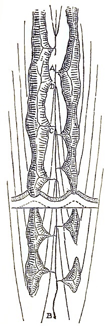
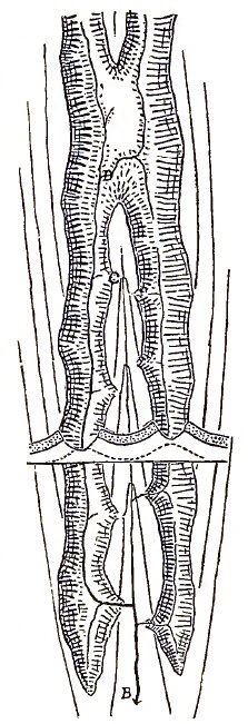
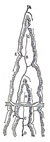
FIG. 11. FIG. 12. FIG. 13.
17. Terminology of rivers changed by adjustment.—A special terminology is needed for easy reference to the several parts of the streams concerned in such an adjustment. Let AB and CD, fig. 14, be streams of unequal size cutting gaps, H and G, in a ridge that lies transverse to their course. CD being larger than AB will deepen its gap faster. Of two subsequent streams, JE and JF, growing on the up-stream side of the ridge, JE will have the steeper slope, because it joins the deeper master-stream. The divide, J, will therefore be driven towards AB, and if all the conditions concerned conspire favorably, JE will at last tap AB at F, and lead the upper part, AF, out by the line FEGD, fig. 15, through the deeper gap, G. We may then say that JE becomes the divertor of AF, which is diverted; and when the process is completed, by the transfer of the divide from J, on the soft rocks, to a stable location, H, on the hard rocks, there will be a short inverted stream, HF; while HB is the remaining beheaded portion of the original stream, AB, and the water-gap of AB becomes a wind-gap, H. It is very desirable that geographic exploration should discover examples of the process of adjustment in its several stages. The preparatory stage is easily recognized by the difference in the size of the two main streams, the difference in the depth of their gaps, and the unsymmetrical position of the divide, J. The very brief stage of transition gives us the rare examples of bifurcating streams. For a short time after capture of the diverted stream by the divertor, the new divide will lie between F and H, in an unstable position, the duration of this time depending on the energy of the process of capture.
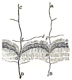
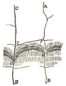
FIG. 14. FIG. 15.
The consequences resulting from readjustments of this kind by which their recent occurrence can be detected are: a relatively sudden increase of volume of the divertor and hence a rapid deepening of the course of the diverting stream, FE, and of the diverted, AF, near the point of capture; small side-streams of these two being unable to keep pace with this change will join their masters in local rapids, which work up stream gradually and fade away (Löwl, Penck, McGee). The expanded portion, ED, of the larger stream, CD, already of faint slope, may be locally overcome for a time with the increase of detritus that will be thus delivered to it at the entrance, E, of the divertor; while the beheaded stream, HB, will find itself embarrassed to live up to the habits of its large valley [Heim]. Geographic exploration with these matters in mind offers opportunity for the most attractive discoveries.
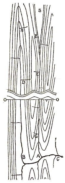
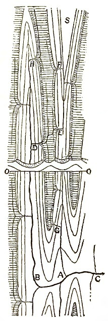
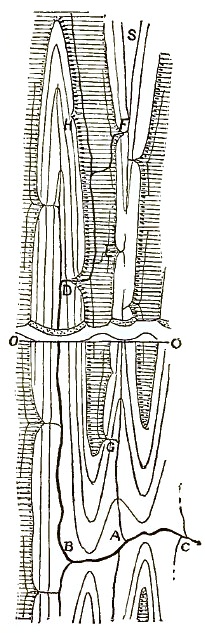
FIG. 16. FIG. 17. FIG. 18.
18. Examples of adjustment.—Another case is roughly figured in the next three diagrams, figs. 16, 17, 18. Two adjacent synclinal streams, EA and HB, join a transverse master stream, C, but the synclines are of different forms; the surface axis of one, EA, stands at some altitude above baselevel until it nearly reaches the place of the transverse stream; while the axis of the other, HB, descends near baselevel at a considerable distance from the transverse stream. As lateral valleys, E and D, are opened on the anticline between the synclines by a process similar to that already described, the divide separating them will shift towards the stream of fainter slope, that is, towards the syncline, EA, whose axis holds its hard beds above baselevel; and in time the upper part of the main stream will be withdrawn from this syncline to follow an easier course by crossing to the other, as in fig. 17. If the elevation of the synclinal axis, AES, take the shape of a long flat arch, descending at the further end into a synclinal lake basin, S, whose outlet is along the arching axis, SA, then the mature arrangement of stream courses will lead the lake outlet away from the axis by some gap in the nearer ascending part of the arch where the controlling hard bed falls near to baselevel, as at F, fig. 18,18 and will take it by some subsequent course, FD, across the lowland that is opened on the soft beds between the synclines, and carry it into the lower syncline, HB, at D where the hard beds descend below baselevel.
18 This figure would be improved if a greater amount of wasting around the margin of the hard bed were indicated in comparison with the preceding figure.
The variety of adjustments following the general principle here indicated is infinite. Changes of greater or less value are thus introduced in the initial drainage areas, until, after attaining an attitude of equilibrium, further change is arrested, or if occurring, is relatively insignificant. It should be noticed that the new stream courses thus chosen are not named by any of the terms now current to express the relation of stream and land history; they are neither consequent, antecedent nor superimposed. The stream is truly still an original stream, although no longer young; but its channel is not in all parts strictly consequent on the initial constructional form of the land that it drains. Streams thus re-arranged may therefore be named original streams of mature adjustment.
It should be clearly recognized that the process of adjustment is a very slow one, unless measured in the extremely long units of a river's life. It progresses no faster than the weathering away of the slopes of a divide, and here as a rule weathering is deliberate to say the least, unless accelerated by a fortunate combination of favoring conditions. Among these conditions, great altitude of the mass exposed to erosion stands first, and deep channeling of streams below the surface—that is, the adolescent stage of drainage development—stands second. The opportunity for the lateral migration of a divide will depend on the inequality of the slopes on its two sides, and here the most important factors are length of the two opposite stream courses from the water parting to the common baselevel of the two, and inequality of structure by which one stream may have an easy course and the other a hard one. It is manifest that all these conditions for active shifting of divides are best united in young and high mountain ranges, and hence it is that river adjustments have been found and studied more in the Alps than elsewhere.
19. Revival of rivers by elevation and drowning by depression.—I make no contention that any river in the world ever passed through a simple uninterrupted cycle of the orderly kind here described. But by examining many rivers, some young and some old, I do not doubt that this portrayal of the ideal would be found to be fairly correct if opportunity were offered for its development. The intention of the sketch is simply to prepare the way for the better understanding of our actual rivers of more complicated history.
At the close or at any time during the passage of an initial cycle such as the one just considered, the drainage area of a river system may be bodily elevated. The river is then turned back to a new youth and enters a new cycle of development. This is an extremely common occurrence with rivers, whose life is so long that they commonly outlive the duration of a quiescent stage in the history of the land. Such rivers may be called revived. Examples may be given in which streams are now in their second or third period of revival, the elevations that separate their cycles following so soon that but little work was accomplished in the quiescent intervals.
The antithesis of this is the effect of depression, by which the lower course may be drowned, flooded or fjorded. This change is, if slow, favorable to the development of flood-plains in the lower course; but it is not essential to their production. If the change is more rapid, open estuaries are formed, to be transformed to delta-lowlands later on.
20. Opportunity for new adjustments with revival.—One of the most common effects of the revival of a river by general elevation is a new adjustment of its course to a greater or less extent, as a result of the new relation of baselevel to the hard and soft beds on which the streams had adjusted themselves in the previous cycle. Synclinal mountains are most easily explained as results of drainage changes of this kind [Science, Dec. 21st, 1888]. Streams thus rearranged may be said to be adjusted through elevation or revival. It is to be hoped that, as our study advances, single names of brief and appropriate form may replace these paraphrases; but at present it seems advisable to keep the desired idea before the mind by a descriptive phrase, even at the sacrifice of brevity. A significant example may be described.
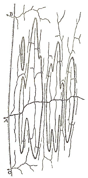
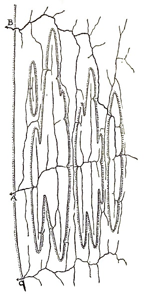
FIG. 19. FIG. 20.
Let it be supposed that an originally consequent river system has lived into advanced maturity on a surface whose structure is, like that of Pennsylvania, composed of closely adjacent anticlinal and synclinal folds with rising and falling axes, and that a series of particularly resistant beds composes the upper members of the folded mass. The master stream, A, fig. 19, at maturity still resides where the original folds were lowest, but the side streams have departed more less from the axes of the synclinals that they first followed, in accordance with the principles of adjustment presented above. The relief of the surface is moderate, except around the synclinal troughs, where the rising margins of the hard beds still appear as ridges of more or less prominence. The minute hachures in figure 19 are drawn on the outcrop side of these ridges. Now suppose a general elevation of the region, lifting the synclinal troughs of the hard beds up to baselevel or even somewhat above it. The deepening of the revived master-stream will be greatly retarded by reason of its having to cross so many outcrops of the hard beds, and thus excellent opportunity will be given for readjustment by the growth of some diverting stream, B, whose beginning on adjacent softer rocks was already made in the previous cycle. This will capture the main river at some up-stream point, and draw it nearly all away from its hard path across the synclinal troughs to an easier path across the lowlands that had been opened on the underlying softer beds, leaving only a small beheaded remnant in the lower course. The final re-arrangement may be indicated in fig. 20. It should be noted that every capture of branches of the initial main stream made by the diverting stream adds to its ability for further encroachments, for with increase of volume the channel is deepened and a flatter slope is assumed, and the whole process of pushing away the divides is thereby accelerated. In general it may be said that the larger the stream and the less its elevation above baselevel, the less likely is it to be diverted, for with large volume and small elevation it will early cut down its channel so close to baselevel that no other stream can offer it a better course to the sea; it may also be said that, as a rule, of two equal streams, the headwaters of the one having a longer or a harder course will be diverted by a branch of the stream on the shorter or easier course. Every case must therefore be examined for itself before the kind of re-arrangement that may be expected or that may have already taken place can be discovered.
21. Antecedent and superimposed rivers.—It not infrequently happens that the surface, on which a drainage system is more or less fully developed, suffers deformation by tilting, folding or faulting. Then, in accordance with the rate of disturbance, and dependent on the size and slope of the streams and the resistance of the rocks, the streams will be more or less re-arranged, some of the larger ones persisting in their courses and cutting their channels down almost as fast as the mass below them is raised and offered to their action. It is manifest that streams of large volume and considerable slope are the ones most likely to persevere in this way, while small streams and large ones of moderate slope may be turned from their former courses to new courses consequent on the new constructional form of the land. Hence, after a disturbance, we may expect to find the smaller streams of the former cycle pretty completely destroyed, while some of the larger ones may still persist; these would then be called antecedent streams in accordance with the nomenclature introduced by Powell.19 A fuller acquaintance with the development of our rivers will probably give us examples of river systems of all degrees of extinction or persistence at times of disturbance.
19 Exploration of the Colorada River of the West, 1875, 153, 163-166.
Since Powell introduced the idea of antecedent valleys and Tietze, Medlicott and others showed the validity of the explanation in other regions than the one for which it was first proposed, it has found much acceptance. Löwl's objection to it does not seem to me to be nearly so well founded as his suggestion of an additional method of river development by means of backward headwater erosion and subsequent capture of other streams, as already described. And yet I cannot help thinking that the explanation of transverse valleys as antecedent courses savors of the Gordian method of explaining a difficult matter. The case of the Green river, to which Powell first gave this explanation, seems well supported; the examples given by Medlicott in the Himalayas are as good: but still it does not seem advisable to explain all transverse streams in this way, merely because they are transverse. Perhaps one reason why the explanation has become so popular is that it furnishes an escape from the old catastrophic idea that fractures control the location of valleys, and is at the same time fully accordant with the ideas of the uniformitarian school that have become current in this half of our century. But when it is remembered that most of the streams of a region are extinguished at the time of mountain growth, that only a few of the larger ones can survive, and that there are other ways in which transverse streams may originate,20 it is evident that the possibility of any given transverse stream being antecedent must be regarded only as a suggestion, until some independent evidence is introduced in its favor. This may be difficult to find, but it certainly must be searched for; if not then forthcoming, the best conclusion may be to leave the case open until the evidence appears. Certainly, if we find a river course that is accordant in its location with the complicated results of other methods of origin, then the burden of proof may be said to lie with those who would maintain that an antecedent origin would locate the river in so specialized a manner. Even if a river persist for a time in an antecedent course, this may not prevent its being afterwards affected by the various adjustments and revivals that have been explained above: rivers so distinctly antecedent as the Green and the Sutlej may hereafter be more or less affected by processes of adjustment, which they are not yet old enough to experience. Hence in mountains as old as the Appalachians the courses of the present rivers need not coincide with the location of the pre-Permian rivers, even if the latter persisted in their courses through the growth of the Permian folding; subsequent elevations and adjustments to hard beds, at first buried and unseen, may have greatly displaced them, in accordance with Löwl's principle.
20 Hilber, Pet. Mitth., xxxv, 1889, 13.
When the deeper channelling of a stream discovers an unconformable subjacent terrane, the streams persist at least for a time in the courses that were determined in the overlying mass; they are then called superimposed (Powell), inherited (Shaler), or epigenetic (Richthofen). Such streams are particularly liable to readjustment by transfer of channels from courses that lead them over hard beds to others on which the hard beds are avoided; for the first choice of channels, when the unconformable cover was still present, was made without any knowledge of the buried rock structure or of the difficulties in which the streams would be involved when they encountered it. The examples of falls produced when streams terrace their flood-plains and run on buried spurs has already been referred to as superimposed; and the rivers of Minnesota now disclosing half-buried ledges here and there may be instanced as illustrating the transition stage between simple consequent courses, determined by the form of the drift sheet on which their flow began, and the fully inconsequent courses that will be developed there in the future.
22. Simple, compound, composite and complex rivers.—We have thus far considered an ideal river. It now seems advisable to introduce a few terms with which to indicate concisely certain well marked peculiarities in the history of actual rivers.
An original river has already been defined as one which first takes possession of a land area, or which replaces a completely extinguished river on a surface of rapid deformation.
A river may be simple, if its drainage area is of practically one kind of structure and of one age; like the rivers of southern New Jersey. Such rivers are generally small. It may be composite, when drainage areas of different structure are included in the basin of a single stream. This is the usual case.
A compound river is one which is of different ages in its different parts; as certain rivers of North Carolina, which have old headwaters rising in the mountains, and young lower courses traversing the coastal plain.
A river is complex when it has entered a second or later cycle of development; the headwaters of a compound river are therefore complex, while the lower course may be simple, in its first cycle. The degree of complexity measures the number of cycles that the river has entered.
When the study of rivers is thus attempted, its necessary complications may at first seem so great as to render it of no value; but in answer to this I believe that it may be fairly urged that, although complicated, the results are true to nature, and if so, we can have no ground of complaint against them. Moreover, while it is desirable to reduce the study of the development of rivers to its simplest form, in order to make it available for instruction and investigation, it must be remembered that this cannot be done by neglecting to investigate the whole truth in the hope of avoiding too great complexity, but that simplicity can be reached safely only through fullness of knowledge, if at all.
It is with these points in mind that I have attempted to decipher the history of the rivers of Pennsylvania. We find in the Susquehanna, which drains a great area in the central part of the state, an example of a river which is at once composite, compound and highly complex. It drains districts of divers structure; it traverses districts of different ages; and it is at present in its fourth or fifth degree of complexity, its fourth or fifth cycle of development at least. In unravelling its history and searching out the earlier courses of streams which may have long since been abandoned in the processes of mature adjustment, it will be seen that the size of the present streams is not always a measure of their previous importance, and to this we may ascribe the difficulty that attends the attempt to decipher a river's history from general maps of its stream lines. Nothing but a detailed examination of geological structure and history suffices to detect facts and conditions that are essential to the understanding of the result.
If the postulates that I shall use seem unsound and the arguments seem overdrawn, error may at least be avoided by not holding fast to the conclusions that are presented, for they are presented only tentatively. I do not feel by any means absolutely persuaded of the correctness of the results, but at the same time deem them worth giving out for discussion. The whole investigation was undertaken as an experiment to see where it might lead, and with the hope that it might lead at least to a serious study of our river problems.
PART FOURTH. The development of the rivers of Pennsylvania.
23. Means of distinguishing between antecedent and adjusted consequent rivers.—The outline of the geological history of Pennsylvania given above affords means of dividing the long progress of the development of our rivers into the several cycles which make up their complete life. We must go far back into the past and imagine ancient streams flowing down from the Archean land towards the paleozoic sea; gaining length by addition to their lower portions as the land grew with the building on of successive mountain ranges; for example, if there were a Cambro-Silurian deformation, a continuation of the Green Mountains into Pennsylvania, we suppose that the pre-existent streams must in some manner have found their way westward to the new coastline; and from the date of this mountain growth, it is apparent that any streams then born must have advanced far in their history before the greater Appalachian disturbance began. At the beginning of the latter, as of the former, there must have been streams running from the land into the sea, and at times of temporary elevation of the broad sand-flats of the coal measures, such streams must have had considerable additions to their lower length; rising in long-growing Archean highlands or mountains, snow-capped and drained by glaciers for all we can say to the contrary, descending across the Green Mountain belt, by that time worn to moderate relief in the far advanced stage of its topographic development, and finally flowing across the coal-measure lowlands of recent appearance. It was across the lower courses of such rivers that the Appalachian folds were formed, and the first step in our problem consists in deciding if possible whether the streams held their courses after the antecedent fashion, or whether they were thrown into new courses by the growing folds, so that a new drainage system would be formed. Possibly both conditions prevailed; the larger streams holding their courses little disturbed, and the smaller ones disappearing, to be replaced by others as the slopes of the growing surface should demand. It is not easy to make choice in this matter. To decide that the larger streams persisted and are still to be seen in the greater rivers of to-day, only reversed in direction of flow, is certainly a simple method of treating the problem, but unless some independent reasons are found for this choice, it savors of assumption. Moreover, it is difficult to believe that any streams, even if antecedent and more or less persistent for a time during the mountain growth, could preserve till now their pre-Appalachian courses through all the varying conditions presented by the alternations of hard and soft rocks through which they have had to cut, and at all the different altitudes above baselevel in which they have stood. A better means of deciding the question will be to admit provisionally the occurrence of a completely original system of consequent drainage, located in perfect accord with the slopes of the growing mountains; to study out the changes of stream-courses that would result from later disturbances and from the mutual adjustments of the several members of such a system in the different cycles of its history; and finally to compare the courses thus deduced with those now seen. If there be no accord, either the method is wrong or the streams are not consequent but of some other origin, such as antecedent; if the accord between deduction and fact be well marked, varying only where no definite location can be given to the deduced streams, but agreeing where they can be located more precisely, then it seems to me that the best conclusion is distinctly in favor of the correctness of the deductions. For it is not likely, even if it be possible, that antecedent streams should have accidentally taken, before the mountains were formed, just such locations as would have resulted from the subsequent growth of the mountains and from the complex changes in the initial river courses due to later adjustments. I shall therefore follow the deductive method thus indicated and attempt to trace out the history of a completely original, consequent system of drainage accordant with the growth of the central mountain district.
In doing this, it is first necessary to restore the constructional topography of the region; that is, the form that the surface would have had if no erosion had accompanied its deformation. This involves certain postulates which must be clearly conceived if any measure of confidence is to be gained in the results based upon them.
24. Postulates of the argument.—In the first place, I assume an essential constancy in the thickness of the paleozoic sediments over the entire area in question. This is warranted here because the known variations of thickness are relatively of a second order, and will not affect the distribution of high and low ground as produced by the intense Permian folding. The reasons for maintaining that the whole series had a considerable extension southeast of the present margin of the Medina sandstone have already been presented.
In the second place, I shall assume that the dips and folds of the beds now exposed at the surface of the ground may be projected upwards into the air in order to restore the form of the eroded beds. This is certainly inadmissible in detail, for it cannot be assumed that the folded slates and limestones of the Nittany valley, for instance, give any close indication of the form that the coal measures would have taken, had they extended over this district, unworn. But in a general way, the Nittany massif was a complex arch in the coal measures as well as in the Cambrian beds; for our purpose and in view of the moderate relief of the existing topography, it suffices to say that wherever the lower rocks are now revealed in anticlinal structure, there was a great upfolding and elevation of the original surface; and wherever the higher rocks are still preserved, there was a relatively small elevation.
In the third place, I assume that by reconstructing from the completed folds the form which the country would have had if unworn, we gain a sufficiently definite picture of the form through which it actually passed at the time of initial and progressive folding. The difference between the form of the folds completely restored and the form that the surface actually reached is rather one of degree than of kind; the two must correspond in the general distribution of high and low ground and this is the chief consideration in our problem. When we remember how accurately water finds its level, it will be clearer that what is needed in the discussion is the location of the regions that were relatively raised and lowered, as we shall then have marked out the general course of the consequent water ways and the trend of the intervening constructional ridges.
Accepting these postulates, it may be said in brief that the outlines of the formations as at present exposed are in effect so many contour lines of the old constructional surface, on which the Permian rivers took their consequent courses. Where the Trenton limestone is now seen, the greatest amount of overlying strata must have been removed; hence the outline of the Trenton formation is our highest contour line. Where the Helderberg limestone appears, there has been a less amount of material removed; hence the Helderberg outcrop is a contour of less elevation. Where the coal beds still are preserved, there has been least wasting, and these beds therefore mark the lowest contour of the early surface. It is manifest that this method assumes that the present outcrops are on a level surface; this is not true, for the ridges through the State rise a thousand feet more or less over the intervening valley lowlands, and yet the existing relief does not count for much in discussing the enormous relief of the Permian surface that must have been measured in tens of thousands of feet at the time of its greatest strength.
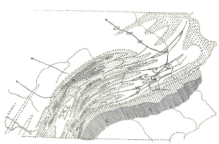
FIG. 21. Constructional Permian topography of Pennsylvania
25. Constructional Permian topography and consequent drainage.—A rough restoration of the early constructional topography is given in fig. 21 for the central part of the State, the closest shading being the area of the Trenton limestone, indicating the highest ground, or better, the places of greatest elevation, while the Carboniferous area is unshaded, indicating the early lowlands. The prevalence of northeast and southwest trends was then even more pronounced than now. Several of the stronger elements of form deserve names, for convenient reference. Thus we have the great Kittatinny or Cumberland highland, C, C, on the southeast, backed by the older mountains of Cambrian and Archean rocks, falling by the Kittatinny slope to the synclinal lowland troughs of the central district. In this lower ground lay the synclinal troughs of the eastern coal regions, and the more local Broad Top basin, BT, on the southwest, then better than now deserving the name of basins. Beyond the corrugated area that connected the coal basins rose the great Nittany highland, N, and its southwest extension in the Bedford range, with the less conspicuous Kishicoquilas highland, K, in the foreground. Beyond all stretched the great Alleghany lowland plains. The names thus suggested are compounded of the local names of to-day and the morphological names of Permian time.
What would be the drainage of such a country? Deductively we are led to believe that it consisted of numerous streams as marked in full lines on the figure, following synclinal axes until some master streams led them across the intervening anticlinal ridges at the lowest points of their crests and away into the open country to the northwest. All the enclosed basins would hold lakes, overflowing at the lowest part of the rim. The general discharge of the whole system would be to the northwest. Here again we must resort to special names for the easy indication of these well-marked features of the ancient and now apparently lost drainage system. The master stream of the region is the great Anthracite river, carrying the overflow of the Anthracite lakes off to the northwest and there perhaps turning along one of the faintly marked synclines of the plateau and joining the original Ohio, which was thus confirmed in its previous location across the Carboniferous marshes. The synclinal streams that entered the Anthracite lakes from the southwest may be named, beginning on the south, the Swatara, S, fig. 21, the Wiconisco, Wo, the Tuscarora-Mahanoy, M, the Juniata-Catawissa, C, and the Wyoming, Wy. One of these, probably the fourth, led the overflow from the Broad Top lake into the Catawissa lake on the middle Anthracite river. The Nittany highland formed a strong divide between the central and northwestern rivers, and on its outer slope there must have been streams descending to the Alleghany lowlands; and some of these may be regarded as the lower courses of Carboniferous rivers, that once rose in the Archean mountains, now beheaded by the growth of mountain ranges across their middle.
26. The Jura mountains homologous with the Permian Alleghanies.—However willing one may be to grant the former existence of such a drainage system as the above, an example of a similar one still in existence would be acceptable as a witness to the possibilities of the past. Therefore we turn for a moment to the Jura mountains, always compared to the Appalachians on account of the regular series of folds by which the two are characterized. But while the initial topography is long lost in our old mountains, it is still clearly perceptible in the young Jura, where the anticlines are still ridges and the longitudinal streams still follow the synclinal troughs; while the transverse streams cross from one synclinal valley to another at points where the intervening anticlinal arches are lowest.21 We could hardly ask for better illustration of the deductive drainage system of our early Appalachians than is here presented.
21 This is beautifully illustrated in the recent monograph by La Noë and Margerie on "Les Formes du Terrain."
27. Development and adjustment of the Permian drainage.—The problem is now before us. Can the normal sequence of changes in the regular course of river development, aided by the post-Permian deformations and elevations, evolve the existing rivers out of the ancient ones?
In order to note the degree of comparison that exists between the two, several of the larger rivers of to-day are dotted on the figure. The points of agreement are indeed few and small. Perhaps the most important ones are that the Broad Top region is drained by a stream, the Juniata, which for a short distance follows near the course predicted for it; and that the Nittany district, then a highland, is still a well-marked divide although now a lowland. But there is no Anthracite river, and the region of the ancient coal-basin lakes is now avoided by large streams; conversely, a great river—the Susquehanna—appears where no consequent river ran in Permian time, and the early synclinal streams frequently turn from the structural troughs to valleys located on the structural arches.
28. Lateral water-gaps near the apex of synclinal ridges.—One of the most frequent discrepancies between the hypothetical and actual streams is that the latter never follow the axis of a descending syncline along its whole length, as the original streams must have done, but depart for a time from the axis and then return to it, notching the ridge formed on any hard bed at the side instead of at the apex of its curve across the axis of the syncline. There is not a single case in the state of a stream cutting a gap at the apex of such a synclinal curve, but there are perhaps hundreds of cases where the streams notch the curve to one side of the apex. This, however, is precisely the arrangement attained by spontaneous adjustment from an initial axial course, as indicated in figure 13. The gaps may be located on small transverse faults, but as a rule they seem to have no such guidance. It is true that most of our streams now run out of and not into the synclinal basins, but a reason for this will be found later; for the present we look only at the location of the streams, not at their direction of flow. As far as this illustration goes, it gives evidence that the smaller streams at least possess certain peculiarities that could not be derived from persistence in a previous accidental location, but which would be necessarily derived from a process of adjustment following the original establishment of strictly consequent streams. Hence the hypothesis that these smaller streams were long ago consequent on the Permian folding receives confirmation; but this says nothing as to the origin of the larger rivers, which might at the same time be antecedent.
29. Departure of the Juniata from the Juniata-Catawissa syncline.—It may be next noted that the drainage of the Broad Top region does not follow a single syncline to the Anthracite region, as it should have in the initial stage of the consequent Permian drainage, but soon turns aside from the syncline in which it starts and runs across country to the Susquehanna. It is true that in its upper course the Juniata departs from the Broad Top region by one of the two synclines that were indicated as the probable line of discharge of the ancient Broad Top lake in our restoration of the constructional topography of the State; there does not appear to be any significant difference between the summit altitudes of the Tuscarora-Mahanoy and the Juniata-Catawissa synclinal axes and hence the choice must have been made for reasons that cannot be detected; or it may be that the syncline lying more to the northwest was raised last, and for this reason was taken as the line of overflow. The beginning of the river is therefore not discordant with the hypothesis of consequent drainage, but the southward departure from the Catawissa syncline at Lewistown remains to be explained. It seems to me that some reason for the departure may be found by likening it to the case already given in figs. 16-18. The several synclines with which the Juniata is concerned have precisely the relative attitudes that are there discussed. The Juniata-Catawissa syncline has parallel sides for many miles about its middle, and hence must have long maintained the initial Juniata well above baselevel over all this distance; the progress of cutting down a channel through all the hard Carboniferous sandstones for so great a distance along the axis must have been exceedingly slow. But the synclines next south, the Tuscarora-Mahanoy and the Wiconisco, plunge to the northeast more rapidly, as the rapid divergence of their margins demonstrates, and must for this reason have carried the hard sandstones below baselevel in a shorter distance and on a steeper slope than in the Catawissa syncline. The further southwestward extension of the Pocono sandstone ridges in the southern than in the northern syncline gives further illustration of this peculiarity of form. Lateral capture of the Juniata by a branch of the initial Tuscarora, and of the latter by a branch of the Wiconisco therefore seems possible, and the accordance of the facts with so highly specialized an arrangement is certainly again indicative of the correctness of the hypothesis of consequent drainage, and this time in a larger stream than before. At first sight, it appears that an easier lateral capture might have been made by some of the streams flowing from the outer slope of the Nittany highland; but this becomes improbable when it is perceived that the heavy Medina sandstone would here have to be worn through as well as the repeated arches of the Carboniferous beds in the many high folds of the Seven Mountains. Again, as far as present appearances go, we can give no sufficient reason to explain why possession of the headwaters of the Juniata was not gained by some subsequent stream of its own, such as G, fig. 18, instead of by a side-stream of the river in the neighboring syncline; but it may be admitted, on the other hand, that as far as we can estimate the chances for conquest, there was nothing distinctly in favor of one or the other of the side-streams concerned; and as long as the problem is solved indifferently in favor of one or the other, we may accept the lead of the facts and say that some control not now apparent determined that the diversion should be, as drawn, through D and not through G. The detailed location of the Juniata in its middle course below Lewistown will be considered in a later section.