NATIONAL GEOGRAPHIC MAGAZINE.
Reading edition
Vol. I. 1889. No. 2.
AFRICA, ITS PAST AND FUTURE.
Africa, the oldest of the continents, containing the earliest remains of man, and the birthplace of European civilization, is the last to be explored. Long before the temples of India or the palaces of Nineveh were built, before the hanging garden of Babylon was planted, the pyramids of Cheops and Cephren had been constructed, the temples of Palmyra and Thebes filled with worshipers.
Greece owes its civilization to Egypt: its beautiful orders of architecture came from the land of the Nile. The civilization of Egypt had grown old, and was in its decay, when Rome was born. Think what a vast abyss of time separates us from the days of Romulus and Remus! And yet the pyramids of Egypt were then older by a thousand years than all the centuries that have passed since then.
For ages upon ages, Africa has refused to reveal its secrets to civilized man, and, though explorers have penetrated it from every side, it remains to-day the dark continent. This isolation of Africa is due to its position and formation. It is a vast, ill-formed triangle, with few good harbors, without navigable rivers for ocean-vessels, lying mainly in the torrid zone. A fringe of low scorched land, reeking with malaria, extends in unbroken monotony all along the coast, threatening death to the adventurous explorer. Our ignorance of Africa is not in consequence of its situation under the equator, for South America in the torrid zone has long been known. There the explorer easily penetrates its recesses on its great rivers,—the Orinoco, Amazon, and La Plata,—for they are navigable from the ocean far into the interior. The Amazon, 3,000 miles from its mouth, is only 210 feet above the ocean-level, and, with its branches, is navigable for 10,000 miles. Africa also has three great rivers,—one on each side of this peninsula. On the north, the Nile, the river of the past, empties into the Mediterranean Sea, but its navigation is soon interrupted by five cataracts; so that the camel, the ship of the desert, bears the wares of Europe from the foot of the first cataract far up the river, 800 miles, to Berber, whence they are again shipped by boat 2,000 miles to Gondokoro, close to the lakes Albert and Victoria Nyanza, 4,000 feet above the sea-level, 4,200 miles by water from the Mediterranean.
On the west, the Kongo, the river of the future, empties into the Atlantic Ocean under the equatorial sun; but its navigation is also impeded by successive falls extending from its mouth to Stanley Pool. Then there is almost uninterrupted navigation on the river and its tributaries for 10,000 miles. Far inland the head waters of its north-eastern branches interlace with the waters of the Nile. Another branch rises in Lake Tanganyika in eastern Africa, while the main river finds its source higher up in the mountains, north of Lake Nyassa, 5,000 feet above the sea-level. On the east the Zambezi, the great river of southern Africa, empties into the Indian Ocean opposite Madagascar. The navigation of its main branch, the Shire, is interrupted not far from the ocean. The Zambezi itself is navigable to the rapids near Tete, 260 miles from its mouth; while one or two hundred miles higher up are the mighty falls of Victoria, only exceeded in volume of water by the Niagara, and nearly equal in height.
In whatever direction Europeans attempted to penetrate Africa, they were met by insurmountable obstacles. Communication by water was prevented by falls near the mouths of great rivers. The greater part of the coast was very unhealthy, and, where not unhealthy, a desert was behind it; but these obstacles, which formerly prevented exploration, now stimulate the traveler. The modern explorations of Africa commenced one hundred years ago, when Mungo Park crossed the Desert of Sahara, and lost his life in descending the Niger. From that time to the present, travelers in ever-increasing numbers have entered Africa from every side. Some who have entered from the Atlantic or Pacific coasts have been lost in its wilds, and two or three years after have emerged on the opposite coast; others have passed from the coast, and have never been heard from. Zanzibar has been a favorite starting-point for the lake region of Central Africa. Stanley started from Zanzibar on his search for Livingstone with two white men, but returned alone. Cameron set out by the same path with two companions, but, upon reaching the lake region, he was alone. Keith Johnson, two or three years ago, started with two Europeans: within a couple of months he was gone. Probably every second man, stricken down by fever or accident, has left his bones to bleach along the road. Drummond, a recent explorer of Africa, chose a route by the Zambezi and Shire Rivers as healthier and more desirable. Let us hear his experience. Early in his journey, at the missionary station of Livingstonia, on Lake Nyanza, he entered a missionary home: it was spotlessly clean; English furniture in the room, books lying about, dishes in the cupboards; but no missionary. He went to the next house: it was the school; the benches and books were there, but neither scholars nor teacher. Next, to the blacksmith shop: there were the tools and anvil, but no blacksmith. And so on to the next and the next, all in perfect order, but all empty. A little way off, among the mimosa groves, under a huge granite mountain, were graves: there were the missionaries.
The Niger is the only river in all Africa navigable by small steamers from the ocean; but the Niger does not give access to the interior, as it rises within 100 miles of the ocean, and, after making a great bend around the mountains of the Guinea coast, empties into the ocean only about five degrees south of its source, after a course of 2,500 miles. Its main branch, the Benue (or "Mother of Waters"), is navigable 500 or 600 miles above its junction with the Niger. The country through which it flows is thickly peopled and well cultivated; but the natives are fierce and warlike, and have until recently prevented any exploration of the Benue.
THE MOUNTAINS OF AFRICA.
As mountain-ranges determine the course of rivers, influence the rainfall, and temper the climate, we must understand the mountain system of Africa before we can understand the continent as a whole.
Standing on the citadel at Cairo, and looking south, you see a sandstone ridge which gradually grows in altitude and width of base as it runs far away to the south, even to the Cape of Good Hope at the other end of Africa. Successive ranges of mountains follow the coast, sometimes near, at others two or three hundred miles inland; the land, in the latter case, ascending from the coast. The only breaks in this long chain are where the Zambezi and Limpopo force their way to the Indian Ocean.
In Abyssinia, on the Red Sea, there is a range of snowy mountains 14,700 feet in height. A few hundred miles to the southeast, and near Lake Victoria Nyanza, almost under the equator, is another snow-capped mountain, Kilima Njaro, 18,700 feet high,—the highest mountain in Africa,—and the mountains of Massai-Land, a continuation of the Abyssinian Mountains. Another range, apparently an offshoot of the long range from the Red Sea, forms a wall 100 miles long, and 10,000 feet high, on the east of Lake Nyassa, separating the waters of that lake from the Indian Ocean. This range continues to the Zambezi. South of this river the mountains rise 8,000 to 10,000 feet in height. In Cape Colony are several ranges of mountains. The highest peak is Compas Berg, 8,500 feet. In the eastern center of Africa, in the equatorial region, is an elevated plateau in which is the lake region, then there is a sudden rise, and a gradual descent towards the Atlantic. There are few continuous ranges of mountains on the western coast; but at Kamerun there is a cluster of mountains reaching an elevation of 13,100 feet; and south of Morocco some of the peaks of the Atlas Mountains reach an elevation of 12,000 to 13,000 feet, but they have little if any influence on the rainfall or temperature of the country. It will be seen from this statement that eastern Africa has high mountain-ranges rising into an elevated plateau; that the land in Equatorial Africa gradually descends toward the west and north-west until within one or two hundred miles of the Atlantic Ocean, when the descent is rapid to the low and unhealthy coast-lands. Through equatorial Africa runs the Kongo, the land north of the Kongo gradually rising to an elevation of about 2,000 feet, and then descending to 1,200 feet at Lake Chad. South of the Kongo the land rises to an elevation of 3,000 feet, and retains this elevation far south into the Portuguese territory.
Careful computations have been made to ascertain the average elevation of the continent. The mean of the most careful estimates is a little over 2,000 feet. The interior is therefore elevated above the miasmatic influences of the coast, but exactly what effect this elevation has upon the temperature can only be ascertained after careful investigation and a series of observations. North of Guinea and Senegambia the coast is less unhealthy; but, as the Desert of Sahara extends to the ocean, the country is of little value, and is therefore left to the native tribes, unclaimed by Europeans.
In the International Scientific Series it is stated that there are in Africa ten active volcanoes,—four on the west coast, and six on the east,—but I have not found any corroboration of this report, and think it very doubtful if there are any volcanoes now in eruption. The Kilima Njaro and Kamerun were formerly active volcanoes, for the craters still exist. In the south the diamond-fields are of volcanic ash formation.
EQUATORIAL AFRICA.
The lake region of Africa stretches from the head waters of the upper Nile three degrees south, to the waters of the Zambezi, fifteen degrees south,—a lake region unequalled, in extent and volume of water, except by our lakes. Here is the Victoria Nyanza, the queen of inland seas, 4,000 feet above the sea-level; and a long series of lakes, great and small, at equal elevation. The more striking are Bangweolo to the south-west, the grave of Livingstone, and Nyassa on the south-east. In their depths the Nile, the Kongo River, and the Shire (the main branch of the Zambezi) have their source.
The great belt of equatorial Africa, situated between the 15th parallel of north latitude and the 15th parallel of south latitude, has continuous rains, is everywhere well watered, and has a rich and fertile soil. Some portions are thickly populated, and it is capable of sustaining a dense population. North and south of this belt there are two other belts of nearly equal width. In each of these belts there are wet and dry seasons, with abundant rain for the crops. The heaviest rainfall in the north belt is in June, while in the south belt it is in December. The rainfall gradually grows less toward the north, and also toward the south, until it ceases in the Desert of Sahara on the north, and in the Desert of Kalahari on the south. On the edge of these deserts are Lake Chad on the north, and Lake Ngami on the south. North of the Desert of Sahara, and south of the Desert of Kalahari, there is an abundant rainfall, a healthy climate, and fertile soil. Morocco, Algiers, and Tripoli, on the Mediterranean, are in the north region; and Zulu-Land, the Orange Free State, and Cape Colony, in the corresponding region of the south.
That portion of Africa north of the equator is three or four times greater than that south, and the Sahara Desert and Lake Chad are several times greater than the Kalahari Desert and Lake Ngami. The Sahara Desert, the waterless ocean three times as large as the Mediterranean, extends from the Atlantic Ocean to the Red Sea, broken only by the narrow valley of the Nile. It is interspersed with oases, with the valleys of many dry streams, and with some mountains 8,000 feet. It has the hottest climate in the world. Travelers tell us, that, in upper Egypt and Nubia, eggs may be baked in the hot sands; that the soil is like fire, and the wind like a flame; that in other parts of the desert the sand on the rocks is sometimes heated to 200° in the day-time, while in the following night the thermometer falls below freezing-point. In crossing the desert the traveler will hardly need a guide, for the road is too clearly marked by the bones and skeletons that point the way.
Lake Chad receives the drainage of a considerable area of country. In the dry season it has no outlet, and is then about the size of Lake Erie. In the wet season it is said to be five times as large. Its level rises by twenty or thirty feet until it overflows into the Desert of Sahara, forming a stream which runs northward for several hundred miles, and is finally lost in a great depressed plain. In the southern part of Africa the level of Lake Ngami rises and falls in a similar manner.
Through the great equatorial belt runs the Kongo, one of the wonderful rivers of the world. The more we know of this river and its tributaries, the more we are impressed by its greatness and importance. Its principal source is in the mountain-range which separates Lake Nyassa from Lake Tanganyika, between 300 and 400 miles west of the Indian Ocean; thence it runs southerly through Lake Bangweolo. On leaving this lake, it takes a north-west course, running from 12° south latitude to 2° north latitude, thence running south-westerly to the ocean, nearly 3,000 miles. The river Sankuru, its principal tributary, empties into the Kongo some distance above Stanley Pool on the south. The mouths of the Sankuru were discovered by Stanley, who was struck by the size and beauty of the river, and by the lakes which probably connect it by a second outlet with the Kongo; but he little realized the magnitude of the river. Even before the journey of Stanley, Portuguese explorers had crossed several large streams far to the south of the Kongo,—the Kuango, the Kassai, and the Lomami,—and explored them for several hundred miles, but were unable to follow them to their mouths. In 1885 and 1886, Wissman and the Belgian explorers sailed up the Sankuru to the streams discovered by the Portuguese. The next largest branch is the Obangi, now called the Obangi-Welle, which flows into the Kongo on the westerly side of the continent, a little south of the equator. An expedition organized by the Kongo Free State steamed up this river in the winter of 1887 and 1888, and solved the problem so long discussed, of the outlet of the Welle. The expedition left the Kongo in the steamer "En Avant," October 26, 1887. It passed several rapids, and steamed to 21° 55' east longitude, when it was stopped by the "En Avant" running on a rock, and the opposition of hostile natives. Here it was only 66 miles from the westernmost point on the Welle reached by Junker, and in the same latitude, each stream running in the same direction, leaving no room to doubt that the two waters unite.
The Little Kibali, which rises a little to the west of Wadelai in the mountains of Sudan, is the initial branch of this river, which bears successively the name of "Kibali" "Welle" and "Doru," and empties into the Kongo under the name of "Obangi," after a course of 1,500 miles.
The discharge of water from the Kongo is only a little less than that from the Amazon, and is said to be three times as great as the discharge from the Mississippi. Grenfel, the English missionary and traveler, says there is no part of the Kongo basin more than one hundred miles from navigable water. What the railroad does for America, the steamboat will do for the Kongo Free State on its seventy-two hundred miles of navigable water.
APPROPRIATION OF AFRICA BY EUROPE.
The English, French, Germans, and Belgians have within a few years planted colonies in Africa. They believe it is more for their interest to colonize Africa than to permit their surplus population to emigrate to America. These countries realize the necessity of creating new markets, if they are to continue to advance. In Africa the colonies must depend upon the home country, and open new fields for manufactures and commerce. They know that in equatorial Africa there are more than 100,000,000 people wanting every thing, even clothes.
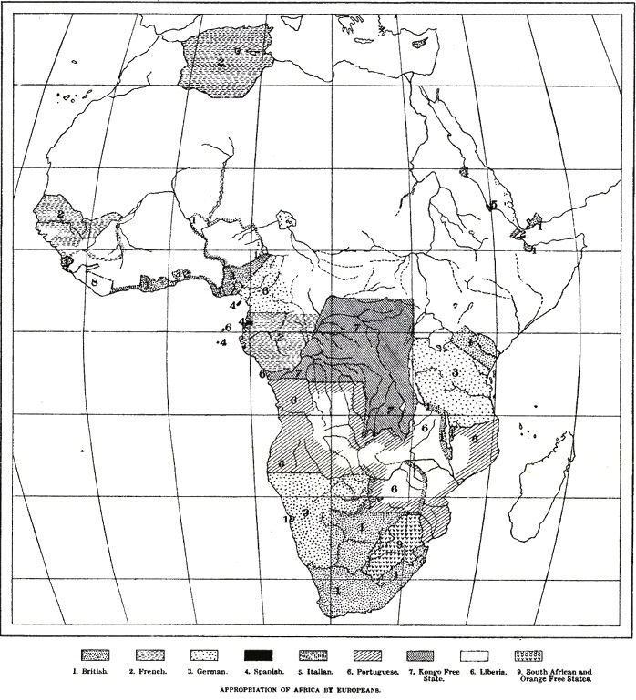
The whole coast of Africa on the Mediterranean Sea, the Atlantic and Indian Oceans from the Red Sea to the Isthmus of Suez, is claimed by European nations, with the exception of two or three small inhospitable and barren strips of coast. England occupies Egypt, and will hold it for an indefinite period. France has its colonies in Tripoli, Algiers, and Morocco, and on the Atlantic coast its factories in Senegambia. It seeks a route from Algiers across the desert to Lake Chad, and from Senegambia up the Senegal by steamer, thence across the country by rail to the head of navigation on the Niger, and down that river to Timbuctu.
England occupies Sierra Leone, the Gold and Slave Coasts, the delta and valley of the Niger, and its branch the Benue. It has factories on these rivers, and small steamers plying on them, and seeks Timbuctu by the river Niger. It controls almost the entire region where the palm-oil is produced.
Timbuctu, long before Africa was known to Europe, was the centre of a large trade in European and Asiatic goods. Caravans crossed the Desert of Sahara from Timbuctu north to the Mediterranean, and east to Gondokoro, carrying out slaves, gold and ivory and bringing back European and Asiatic goods.
Sandwiched between the English possessions, Liberia struggles for existence, its inhabitants fast degenerating into barbarism.
Joining the English possessions on the Gold Coast, two degrees north of the equator, are the German possessions of Kamerun, with high mountains and invigorating breezes; but the land at the foot is no more favorable to the European than the Guinea coast. One or two hundred miles in the interior of this part of the continent, the land rapidly rises to the tableland of equatorial Africa, rich and fertile, resembling the valley of the Kongo, possibly habitable by Europeans.
Next, the French occupy the Ogowe, its branches, and the coast, to the Kongo, and claim the country inland to the possessions of the Kongo Free State. Under M. Brazza, they have thoroughly explored the country to the river Kongo, and have established factories at Franceville and other places.
The Kongo Free State comes next. It holds on the coast only the mouth of the river, its main possessions lying in the interior, Belgium is the only country that has planted colonies inland. Like all the interior of equatorial Africa, the valley of the Kongo is well watered and has continuous rains. The land is rich and fertile, but is practically inaccessible, and, before any extensive commerce can be carried on, must be connected by railroad with the ocean. The Compagnie du Congo has just completed a survey for a railroad on the south side of the Kongo, from Matadi, opposite Vivi, to Stanley Pool. It did not encounter any unusual difficulties, and has submitted the plans and projects to the King of Belgium for his approval.
South of the Kongo Free State are the Portuguese possessions of Angola, Benguela, and Mossamedes. Portugal, the first country to circumnavigate Africa, and the first to colonize it, has for several centuries had factories, and carried on a large trade with Africa, exchanging clothes and blankets for slaves, gold and ivory. It claimed the valley of the Kongo; but the claim has been reduced, and is now bounded for a considerable distance on the north by a line running due east and west on the 6th parallel of south latitude. They have good harbors at St. Paul de Loango, Benguela, and Mossamedes, on the Atlantic coast, and the best harbor of Africa, at Delagoa Bay on the Indian Ocean. The territory claimed will, I believe, prove to be the most valuable in Africa. It is well watered by numerous tributaries of the Kongo and by the Zambezi and its branches. It is higher than the Kongo valley, and is therefore more healthy. Several Portuguese, English, and German travelers have crossed and recrossed this part of the continent, and the Portuguese have some small settlements on the coast and in the interior. The Portuguese of the present generation have not the enterprise and trading spirit of their forefathers, and are doing very little for the settlement of the country.
South of the Portuguese possessions, England claims from the Portuguese possessions on the Atlantic to their possessions on the Pacific, including Namaqua-Land, Cape Colony, the Transvaal, and Zulu-Land.
Namaqua and Damara Land, formerly claimed by the Germans, are now put down on some of the maps as belonging to England. The only harbor on the coast is held by the English; and, from the character of the country, we are not surprised that the Germans have abandoned it, for we are told that "the coast is sandy and waterless, deficient in good harbors, devoid of permanent rivers, washed by never-ceasing surf, bristling with reefs, and overhung by a perpetual haze."
North of Zulu-Land, the Portuguese claim the coast to Zanzibar. Over Zanzibar, Germany has lately assumed the protectorate, under a treaty with the Sultan of the country, claiming the land from the ocean to the great lakes; then England again, a little to the north and far to the west of Zanzibar, the rival of Germany in its claims. The English have factories west of Zanzibar, and a regular route up the Zambezi and Shire Rivers, with a single portage to Lake Nyassa, and a road to Lake Tanganyika. They have steamers on each of the lakes, and several missionary and trading stations. The latest news from this part of Africa says the route to the lakes has been closed, and the missionaries and merchants murdered.
North of the English possessions, the coast to the Red Sea is barren and inhospitable: it has little rain and no harbors, and is so worthless that it has not been claimed by any European nation. North of this region is Abyssinia on the Indian Ocean and Red Sea,—a mountainous country with deep valleys, rich and fertile, but very unhealthy. Three or four thousand feet above the level of the sea, is a healthier country, inhabited by a race of rugged mountaineers, whom it has been impossible to dispossess of their lands. North of Abyssinia, on the Red Sea, Italy has a small colony at Massaua, and England a camp at Suakin. The only parts of the coast not claimed by Europeans are inhospitable, without population or cultivation of any kind.
The Belgians have spent many millions in the exploration of the Kongo and its tributaries. They have eighteen small steamers making trips from Leopoldville up the river to Stanley Falls, and up its branches, supplying the main stations in the basin of the Kongo. The Kongo Free State, unlike all other African colonies, is free to all. Merchants of any nation can establish factories, carry on trade, and enjoy the same privileges and equal facilities with the Belgians. The valley of the Kongo, and the plateau of the great lakes, have a similar climate and soil; but the Kongo is easier of access, provisions are cheaper, more readily obtained, and the natives are less warlike. The Kongo Free State will therefore be more rapidly settled than any other part of Africa excepting Cape Colony.
The trade with these countries is carried on by European companies under royal charter, with quasi-sovereign powers for ruling the country and governing the natives, as well as for trading with them. England, Germany, and Portugal subsidize steamship companies which make regular trips along the western coast, stopping at the different stations.
From this statement it will be seen that England occupies the healthiest portion of Africa (Cape Colony), the most fertile valleys (the Nile and the Niger), the richest gold-fields (Gold Coast and Transvaal); that Portugal comes next, claiming the most desirable portion of equatorial Africa north of Cape Colony and south of the Kongo, but that it is unable to colonize this country, which will inevitably fall under the control of England; that the French claim Algiers and Senegambia, and are contending with England for the trade of Timbuctu and the upper valley of the Niger; that Germany, after vain attempts to penetrate the interior from Kamerun and Angra Pequena, has planted her flag at Zanzibar, and has determined to contest with England the lake region and the great plateaus of Central Africa; while Italy, imitating the other states, tries in vain to obtain a footing on the Red Sea, worthless if obtained.
POPULATION.
The population of Africa is roughly estimated at 200,000,000,—about 18 to a square mile, as against 88 in Europe. It is supposed that Africa was originally inhabited by the Hottentots, or Bushmen, who are now found only in south-western Africa, and by the Pygmies or Dwarfs scattered about Central Africa, who, some say, belong to the same group. This group is noted for its dwarfed stature, generally under five feet; but whether their size is natural, or due to privation and scanty food, is not certainly known. The Hottentot language is distinct from any other known form of speech. The Bantu occupy the greater part of Africa south of the equator. They probably formerly inhabited north-eastern Africa, but were driven from their homes by the Hamites. The Bantu resemble the Negro in their general character, color, and physique, but their language shows essential differences. There are countless tribes of Bantu, each tribe having its own language, yet there was originally a primeval Bantu mother-tongue, from which all the dialects of this immense region are undoubtedly derived. The idioms of this family are generally known as the alliteral class of languages. North of the Bantu are the Negroes proper, occupying the greater part of Africa between 5° and 15° north latitude. The negro tribes are multitudinous, and, though alike in their main physical features, are diverse in their speech.
North of the Negro are the Nuba Fulah group, apparently indigenous to Africa, but without any thing in common with the other indigenous groups. Their name, "Pullo," or "Fulah," means "yellow," and their color serves to distinguish them from the Negro. The Hottentot, Bantu, Negro, and Fulah, though distinct, have each of them the agglutinative forms of speech. The Hamites are found along the valley of the Nile, in Abyssinia, and portions of the Sudan. The Shemitic tribes occupy the larger part of the Sudan, bounded on the east by the Nile, and on the north by the Mediterranean and North Atlantic.
About one-half of the population are Negroes proper, one-fourth Bantu, one-fourth Shemites and Hamites, a few Nuba Fulahs and Hottentots. The Negroes and Bantu are Pagans; the Shemites and Hamites, Mohammedans. There are, almost, innumerable tribes, speaking different languages or different dialects. Over six hundred tribes and languages have been classified by Shilo, yet each is generally unintelligible to the other. Practically speaking, there are but two great divisions,—the Negroes and Bantu, occupying equatorial and southern Africa; and the Hamites and Shemites, northern Africa. But there is no clear-cut line even between the Mohammedan and Negro. For many hundred years the Negroes have been taken as slaves, and carried into the north of Africa, and have furnished the harems with wives, and the families with servants. The servants are often adopted into the families, so that the Negro blood now largely predominates even among the Shemites and Hamites.
A broader and more practical distinction than that of language or blood is made by the religion of the African. The Mohammedan religion was probably brought from Arabia by the Shemites. They conquered the country along the coast, and exterminated or pushed to the south the former inhabitants. Then, more slowly but steadily, Mohammedanism forced its way south by the sword or by proselyting. Within the last thirty years it has re-assumed its proselyting character, and is now more rapidly extending than at any previous time.
Its missionaries are of a race nearly allied to the Negro. They live among them, adopting their customs, and often intermarrying with them. They teach of one God, whom all must worship and obey, and of a future life whose rewards the Negro can comprehend. They forbid the sacrifice of human victims to appease the wrath of an offended deity. They forbid drunkenness. They give freedom to the slave who becomes a Moslem, and thus elevate and civilize those among whom they dwell. The Christian missionary is of a race too far above him. He is a white man, his lord and master. He teaches of things his mind cannot reach, of a future of which he can form no conception; he brings a faith too spiritual; he labors with earnestness and devotion, even to the laying-down of his life. Yet the fact remains that Christianity has produced but little impression in civilizing and elevating the people, while the influence of Mohammedanism is spreading on every side.
In passing from the equator south, the tribes become more degraded. Sir Henry Maine enunciated the theory of the evolution of civilization from the lowest state of the savage. In Africa he could have found all stages of civilization; in the lowest scale, man and his mate, living entirely on the fruits of the earth, in a nude condition, his only house pieces of bark hung from the trees to protect him from the prevailing wind; the vulture his guide to where, the previous night, the lion had fallen on his prey, leaving to him the great marrow-bones of the elephant or the giraffe; his only arms a stick; belonging to no tribe, with no connection with his fellow-men, his hand against every man, the family relation scarcely recognized. It is the land of the gorilla, and there seems to be little difference between the man and the ape, and both are hunted and shot by the Boers. In ascending the scale, the family and tribal relation appears,—a house built of cane and grass or the bark of the tree; a few flocks; skill in setting traps for game; the weapon a round stone, bored through, and a pointed stick fastened in the hole. Then come tribes of a low order of civilization, that cultivate a little ground, having a despotic king, who has wives without limit, numbering in some cases, it is said, 3,000; wives and slaves slaughtered at his death, to keep him company and serve him in another life. With them, cannibalism is common. Then come tribes of a higher civilization, where the power of the chief is limited, where iron, copper, and gold are manufactured, and trade is carried on with foreigners, where fire-arms have been substituted for the bow and spear; next the Mohammedan; and last of all, on the shores of the Mediterranean, the civilization of the French and English.
It is a curious fact that many tribes that had made considerable advance in manufacturing iron and copper, have for some time ceased manufacturing; that others have retrograded, and have lost some of the arts they formerly possessed. This decline apparently took place after the Mohammedans had conquered North Africa, and sent their traders among the Negro tribes, who sold the few articles the Negro needed cheaper than they could manufacture them, and therefore compelled them to give up their own manufactures. Such was the effect of free trade on interior Africa. The Mohammedans also manufacture less than formerly, depending more and more upon European manufactures. The enterprise of the white race defies native competition, and stifles attempts at native manufactures: there is therefore among the natives a great falling-off in the progress of outward culture, and the last traces of home industries are rapidly disappearing.
SLAVE-TRADE.
One of the departments of this society is the geography of life. At the head of all life stands man: it is therefore within our province to investigate those questions which more intimately concern and influence his welfare.
Slavery and the slave-trade have, within the last two hundred years, affected African life more than all other influences combined; and this trade, with all its sinister effects, instead of diminishing, is ever increasing. It has had a marked effect not only on the personal and tribal characters of the inhabitants, but on their social organization, and on the whole industrial and economic life of the country. It has not only utterly destroyed many tribes, but it has made the condition of the other tribes one of restless anarchy and insecurity. It has been the great curse of Africa, and for its existence the nations of Europe have been, and are, largely responsible. The temper and disposition of the Negro make him a most useful slave. He can endure continuous hard labor, live on little, has a cheerful disposition, and rarely rises against his master.
There are two kinds of slavery,—home and foreign. The first has always prevailed in Africa. Prisoners taken in war are sacrificed, eaten, or made slaves. Slavery is also a punishment for certain offences, while in some tribes men frequently sell themselves. These slaves are of the same race and civilization as their masters. They are usually well treated, regarded as members of the family, to whom a son or daughter may be given in marriage, the master often preferring to keep his daughter in the family to marrying her to a stranger. This slavery is a national institution of native growth. It is said one half of the inhabitants are slaves to the other half. The horrors of the slave-trade are unknown in this kind of slavery.
In the other case the slave is torn from his home, carried to people, countries, and climates with which he is unfamiliar, and to scenes and civilization which are uncongenial, where his master is of a different color and of another and higher civilization, where the master and slave have nothing in common. The Spaniards made slaves of the Indians of America, but they were incapable of work, unfitted for slavery, and rapidly faded away. In pity for the Indians, the Africans were brought to supply their places. Their ability to labor was proved, and they were soon in great demand.
It is impossible to ascertain the number of slaves imported into America. The estimates vary from 4,000,000 to 5,000,000. The larger number is probably an underestimate; but these figures do not represent the number shipped from Africa, for 12½ per cent. were lost on the passage, one-third more in the "process of seasoning;" so that, out of 100 shipped from Africa, not more than 50 lived to be effective laborers.
Livingstone, who studied the question of slavery most carefully, estimated, that, for every slave exported, not less than five were slain or perished, and that in some cases only one in ten lived to reach America. If the lowest estimate is taken, then not less than 20,000,000 Negroes were taken prisoners or slain to furnish slaves to America. No wonder that many parts of Africa were depopulated.
Though the slave-trade with America has been suppressed, thousands are annually stolen and sold as slaves in Persia, Arabia, Turkey, and central and northern Africa. Wherever Mohammedanism is the religion, there slavery exists; and to supply the demand the slave-trade is carried on more extensively and more cruelly to-day than at any previous time. The great harvest-field for slaves is in Central Africa, between 10° south and 10° north latitude. From this region caravans of slaves are sent to ports on the Indian Ocean and the Red Sea, and thence shipped to Indo-China, the Persian Gulf, Arabia, Turkey in Asia, and even to Mesopotamia, wherever Mussulmans are found. The English at Suakin are a constant hindrance to this traffic; and therefore Osman Digna has so often within the past five years attacked Suakin, desiring to hold it as a port from which to ship slaves to Arabia. Other caravans are driven across the desert to Egypt, Morocco, and the Barbary States. Portuguese slave-traders are found in Central Africa, and, though contrary to law, deal in slaves, and own and work them in large numbers. Cameron says that Alrez, a Portuguese trader, owned 500 slaves, and that to obtain them, ten villages, having each from 100 to 200 souls, were destroyed; and of those not taken, some perished in the flames, others of want, or were killed by wild beasts. Cameron says, "I do not hesitate to affirm that the worst Arabs are angels of mercy in comparison to the Portuguese and their agents. If I had not seen it, I could not believe that there could exist men so brutal and cruel, and with such gayety of heart." Livingstone says, "I can consign most disagreeable recollections to oblivion, but the slavery scenes come back unbidden, and make me start up at night horrified by their vividness."
If the chief or pacha of a tribe is called upon for tribute by his superior, if he wishes to build a new palace, to furnish his harem, or fill an empty treasury, he sends his soldiers, armed with guns and ammunition, against a Negro tribe armed with bows and spears, and captures slaves enough to supply his wants.
The territory from which slaves are captured is continually extending; for, as soon as the European traveler has opened a new route into the interior, he is followed by the Arab trader, who settles down, cultivates the ground, buys ivory (each pair of tusks worth about $500 at Zanzibar or Cairo); invites others to come, and when they have become acquainted with the country, and gathered large quantities of ivory, and porters are wanted to carry the tusks to the coast, a quarrel is instigated with the Negroes, war declared, captives taken,—men for porters, women for the harem,—the villages are burned, and the caravan of slaves and ivory takes its route to the coast, where all are sold. We are told on good authority that during the past twenty years more slaves have been sent out than formerly were exported in a century. Wissmann tells us what he has seen:—
"In January, 1882, we started from our camp,—200 souls in all,—following the road, sixty feet wide, to a region inhabited by the Basonge, on the Sankuru and Lomami Rivers. The huts were about twenty feet square, divided into two compartments, the furniture consisting of cane and wooden stools; floor, ceiling, and walls covered with grass mats. Between the huts were gardens, where tobacco, tomatoes, pine-apples, and bananas were grown. The fields in the rear down to the river were cultivated with sweet-potatoes, ground-nuts, sugar-cane, manioc, and millet. Goats and sheep and fowls in abundance, homestead follows homestead in never-ending succession. From half-past six in the morning, we passed without a break through the street of the town until eleven. When we left it, it then still extended far away to the south-east. The finest specimens in my collection, such as open-work battle-axes inlaid with copper, spears, and neat utensils, I found in this village.
"Four years had gone by, when I once more found myself near this same village. With joy we beheld the broad savannas, where we expected to recruit our strength and provisions. We encamped near the town, and in the morning approached its palm-groves. The paths were no longer clean, no laughter was heard, no sign of welcome greeted us. The silence of death breathes from the palm-trees, tall grass covers every thing, and a few charred poles are the only evidence that man once dwelt there. Bleached skulls by the roadside, and the skeletons of human hands attached to the poles, tell the story. Many women had been carried off. All who resisted were killed. The whole tribe had ceased to exist. The slave-dealer was Sayol, lieutenant of Tippo-Tip."
Sir Samuel Baker was largely instrumental in the suppression of the slave-trade, and, while the rule of the English and French in Egypt was maintained, slavery was greatly diminished; but, since the defeat and death of Gen. Gordon, the slave-trade has rapidly increased, and is now carried on more actively than at any other time. The only obstacles to this traffic are the presence of Emin Pacha at Wadelai, the English and American missionaries, and English trading-stations on Lakes Victoria Nyanza and Tanganyika.
The slave-traders unite in efforts to destroy Emin Pacha, and to expel the missionaries and all European travelers and traders, except the Portuguese, and for this purpose excite the hostility of the Negro against the foreigner. In this they are aided by the Mahdi. The work of the Mahdi is largely a missionary enterprise. The dervishes who accompany his army are religious fanatics, and desire the overthrow of the Christians and Emin Pacha as earnestly as the slave-trader. Religious fanaticism is therefore united with the greed of the slave-trader to drive out the Christians from the lake region.
Aroused by these reports, and influenced by these views, Cardinal Lavigerie, for twenty years Bishop of Algiers and now Primate of Africa, last summer started a new crusade in Belgium and Germany against slavery and the slave-trade. The cardinal has organized societies, and is raising a large fund to equip two armed steamships for Lake Tanganyika and Lake Nyassa, the headquarters of the slave-trade, and offers, if necessary, to head the band himself. The Pope has engaged in the work, has contributed liberally to this fund, and sent three hundred Catholic missionaries to Central Africa. The slave-trade is carried on with arms and ammunition furnished by European traders. Without these arms, the slave-trade could not be successfully carried on, for the Negroes could defend themselves against slave-traders armed like themselves. While the demand for slaves continues, the slave-trade will exist, and will not cease until the factories of European nations are planted in the interior of Africa.
MINERAL WEALTH OF AFRICA.
We are told in Phillips's "Ore Deposits" that the precious metals do not appear to be very generally distributed in Africa. More thorough research may show that this view is incorrect, and that there are large deposits of iron, copper, gold, and other metals in many parts of the continent. Gold is found on the Gold Coast, in the Transvaal, in the Sudan, and in Central Africa, but is only worked in surface diggings, excepting in the Transvaal; but near all these washings, gold nuggets of large size, and the quartz rock, have been discovered. In Transvaal the mines were worked a long time ago, probably by the Portuguese, then abandoned and forgotten. Recently they have been rediscovered, and worked by the English. In the Kaap gold-field in the Transvaal, three years ago, the lion and zebra, elephant and tiger, roamed undisturbed in the mountain solitudes, where there is now a population of 8,000, with 80 gold-mining companies, having a capital of $18,500,000, one-third of which is paid up. Barberstown, the chief mining-town, has two exchanges, a theatre, two music-halls, canteens innumerable, several churches and hotels, four banks, and a hospital. A railroad was opened in December, 1887, from the Indian Ocean towards these mines, 52 miles, and is being rapidly constructed 100 miles farther to Barberstown.
There is reason to believe that gold deposits equal to those of Mexico or California will yet be found in several parts of Africa. Copper is known to exist in the Orange Free State, in parts of Central and South Africa, and in the district of Katongo, south-west of Lake Tanganyika, which Dr. Livingstone was about to explore in his last journey. Rich copper ores are also found in the Cape of Good Hope, Abyssinia, and equatorial Africa. Large and excellent deposits of iron ore have been found in the Transvaal and in Algiers, and a railroad 20 miles long has been built to carry it from the Algerian mines to the sea. Very many tribes in equatorial and Central Africa work both iron and copper ores into different shapes and uses, showing that the ore-beds must be widely distributed.
One of the few large diamond-fields of the world is found in Griqua and Cape Colony, at the plateau of Kimberly, 3,000 feet above the sea. The dry diggings have been very productive; this tract, when first discovered, being almost literally sown with diamonds.
Coal has been found in Zulu-Land, on Lake Nyassa, and in Abyssinia. The latter coal-field is believed to be secondary. Iron, lead, zinc, and other minerals, have been found in the Orange Free State. Salt-beds, salt-fields, salt-lakes, and salt-mines are found in different parts of Africa.
RAILROADS.
The peculiar formation of Africa, its long inland navigation, interrupted by the falls near the mouths of its large rivers, from connection with the ocean, render it necessary to connect the ocean with the navigable parts of the rivers by railroads.
The Belgians will soon construct a railroad on the southerly side of the Kongo, to the inland navigable waters of the Kongo at Leopoldville, following the preliminary surveys lately completed; the French may also construct a road from the coast to Stanley Pool; and by one or the other of these routes the interior of Africa will be opened.
South of the Kongo, the Portuguese are constructing a railroad from Benguela into the interior. In Cape Colony railroads connect the greater part of the British possessions with the Cape of Good Hope. A railroad is also being constructed from Delagoa Bay to the mines in Transvaal.
Sudan and the upper waters of the Nile can only be opened to a large commerce by a railroad from Suakin to Berber, about 280 miles. Surveys were made for this road, and some work was done upon it, just before Gen. Gordon's death. The navigation of the Nile above Berber is uninterrupted for many hundred miles. Below Berber the falls interrupt the navigation. The route from Gondokoro down the Nile is by boat to Berber, camel to Assuan, boat to Siut, and railroad to Cairo and Alexandria, making a route so circuitous that it prevents the opening of the Sudan to any extensive commerce.
In Algiers there are 1,200 miles of railroad, and more are being constructed. The French are constructing a railroad from the upper part of the Senegal River to the head waters of the Niger. The English have organized a company to construct a road from the Gold Coast to the mines in the interior.
It will thus be seen that the railroad has already opened a way into Africa that is sure to be carried on more extensively.
STANLEY EXPEDITION.
There are two methods of exploring Africa. One is where an individual, like a Livingstone, or a Schweinfurth, or a Dr. Junker, departs on his journey alone. He joins some tribe as far in the interior, on the line of exploration, as possible; lives with the tribe, adopting its habits and manner of life, learning its language, making whatever explorations he can; and, when the region occupied by such tribe has been fully explored, leaves it for the next farther on. This plan requires time and never-failing patience; but in this way large portions of Africa have been explored. The other way, adopted by Cameron, Stanley, Wissmann, and the Portuguese explorers, has been to collect a party of natives, and at their head march across the continent.
"An immense outfit is required to penetrate this shopless land, and the traveler can only make up his caravan from the bazaar at Zanzibar. The ivory and slave-traders have made caravanning a profession, and every thing the explorer wants is to be found in these bazaars, from a tin of sardines to a repeating-rifle. Here these black villains the porters—the necessity and despair of travelers, the scum of slave-gangs, and the fugitives from justice from every tribe—congregate for hire. And if there is any thing in which African travelers are for once agreed, it is, that for laziness, ugliness, stupidity, and wickedness, these men are not to be matched on any continent in the world." Upon such men as these Stanley was obliged to depend.
Though traveling in this way is more rapid than the other, it is very expensive, and has many difficulties not encountered by the solitary traveler. The explorer always goes on foot, following as far as possible the beaten paths. A late traveler says: "The roads over which the land-trade of equatorial Africa now passes from the coast to the interior are mere footpaths, never over a foot in breadth, beaten as hard as adamant, and rutted beneath the level of the forest-bed by centuries of native traffic. As a rule, these foot-paths are marvellously direct. Like the roads of the old Roman, they move straight on through every thing,—ridge and mountain and valley,—never shying at obstacles, nor anywhere turning aside to breathe. No country in the world is better supplied with paths. Every village is connected with some other village, every tribe with the next tribe, and it is possible for a traveler to cross Africa without being once out of a beaten track."
But if the tribes using these roads are destroyed, the roads are discontinued, and soon become obstructed by the rapid growth of the underbrush; or, if the route lies through unknown regions outside the great caravan-tracks, the paths are very different from those described by Mr. Drummond, for the way often lies through swamps and morass, or thick woods, or over high mountain-passes, or is lost in a wilderness of waters.
The great difficulty in these expeditions is to obtain food. As supplies cannot be carried, they must be procured from the natives. Very few tribes can furnish food for a force of six hundred men (the number with Stanley); and when they have the food, they demand exorbitant prices. Often the natives not only refuse food to the famished travelers, but oppose them with such arms as they have; and then it is necessary, in self-defence, to fire upon them.
The greatest difficulty the explorer meets comes either directly or indirectly from the opposition of the slave-trader. Formerly the slave-trader was not found in equatorial Africa; but, since the explorer has opened the way, the slave-trader has penetrated far into the interior, and is throwing obstacles in the way of the entry of Europeans into Africa. When it was decided that Stanley should relieve Emin Pacha, he was left to choose his route. He met Schweinfurth, Junker, and other African travelers, in Cairo. They advised him to go by his former route directly from Zanzibar to the Victoria Nyanza. The dangers and difficulties of this route, and the warlike character of the natives, he well knew. The route by the Kongo to Wadelai had never been traveled, and he thought the difficulties could not be greater than by the old route; and, beside, he proceeded much farther into the interior by steamer on the Kongo, which left a much shorter distance through the wilderness than by the Zanzibar route. On arriving at Zanzibar, he made an arrangement with Tippo-Tip, the great Arab trader and slave-dealer, for a large number of porters. They sailed from Zanzibar to the Kongo, where Stanley arrived in February, 1887. He then sailed up the Kongo, and arrived in June at the junction of the Aruvimi with the Kongo, a short distance below Stanley Falls. Stanley believed that the Aruvimi and the Welle were the same stream, and that by following up this river he would be on the direct route to Wadelai. Subsequent investigations have shown that he was mistaken. About the 1st of July he left the Kongo, expecting to reach Emin Pacha in October, 1887. No definite information has been received from him from that time to the present. He left Tippo-Tip in command at Stanley Falls, and expected that a relief expedition would follow. There were great delays in organizing this expedition, from the difficulty of obtaining men, and it was thought that Tippo-Tip was unfaithful. The men were finally procured, and the expedition left Aruvimi in June, 1888, under command of Major Barttelot. A day or two after they started, Major Barttelot was murdered by one of his private servants. The expedition returned to the Kongo, and was re-organized under Lieut. Jamieson. He was taken ill, and died just as he was ready to start, and no one has been found to take his place; and that relief expedition was abandoned. Reports say that Stanley found the route more difficult than he anticipated; heavy rainfall, rivers, swamps, and marshes obstructed the way; that the season was sickly, and a large part of his followers died long before he could have reached Emin Pacha.
The reports of his capture, and of his safe return to the Aruvimi River, are known to all. These may or may not be true. Although we have not heard from Stanley for a year and a half, yet it by no means follows that he is dead; for Livingstone, Stanley, and other explorers have been lost for a longer time, and have afterward found their way back to the coast. No man has greater knowledge of the country through which his route lay, or of the character of the natives, or the best manner of dealing with them. Emin Pacha was encamped quietly for nearly two years at Wadelai; and Stanley, in like manner, may have been compelled to remain at some inland point and raise his own provisions.
THE FUTURE OF AFRICA.
It is impossible to prophesy the future of any country, much less that of Africa, where the physical features have left so marked an impression upon its inhabitants, and where the animal life is so different from that of the other continents. It is rather by differentiating Africa from other countries that we obtain any data from which to form an opinion of its future.
Africa, as we have seen, is surrounded by a fringe of European settlements. What effect will these settlements have upon Africa? Will the European population penetrate the interior, and colonize Africa? Will it subjugate or expel the Africans, or will they fade away like the Indians of our country? If colonization by Europeans fail, will the African remain the sole inhabitant of the country as barbarian or civilized?
Egypt is now controlled by the English, but its climate is too unhealthy, and its surrounding too unfavorable, for Englishmen; and we may safely assume that their occupation will be temporary, or, if permanent, not as colonists. They will remain, as in India, foreigners and rulers, until the subjugated people rise in their power and expel them, and return to their old life. The English rule, though possibly beneficial to Egypt, is hated by the natives, who demand Egypt for the Egyptians.
Leaving Egypt, we pass an uninhabitable coast, until we come to the French colonies of Algiers. It is nearly sixty years since the French took possession of Algiers. There has been a large emigration from France; but the climate, while excellent as a winter climate for invalids and others, is unfavorable for a permanent habitation, especially for infants. The births in one year have never equalled the deaths. When Algeria was first conquered by the French, it was a wilderness, but is now a garden. The cultivation of the grape has been most successful, and extensive iron-mines have been opened. The French are gradually pushing their way from Algiers across the desert to Timbuctu, and also from Senegambia to Timbuctu. The expense of maintaining Algeria has greatly exceeded any revenue derived from it. Though many doubt the political wisdom of retaining it, yet the French have too much pride to acknowledge that the enterprise has been in any way a failure; and they will undoubtedly hold it, and perhaps found an empire. Senegambia and the coast of Guinea, claimed by the French and English, are low and moist, filled with swamps and lagoons, which will prevent any European colonization.
South of the Kongo, the Portuguese claim a wide section of country running across Africa. They have occupied this country over two hundred years. They have done little towards colonizing, and only hold a few trading-posts on the coast and in the interior, dealing principally in slaves, ivory, and gold; and it may well be doubted whether they have the stamina or ability to colonize this country, or to produce any permanent impression upon it.
The south portion of Africa, from the 18th parallel on the Atlantic to the 26th parallel on the Indian Ocean, is generally fertile; and the climate is favorable to Europeans, and is capable of sustaining a large population. The growth of Cape Colony has been very slow, but a more rapid growth is anticipated. We believe it will be permanently occupied by the English, who will dispossess the aborigines, and form a great and permanent English State. The coast of Zanzibar, occupied by the Germans and English, is rich and fertile, the climate unhealthy; but when the mountain-ranges are crossed, and the elevated plateaus and lake regions are reached, the interior resembles the Kongo region. Massaua and Suakin, on the Red Sea, are unhealthy and worthless, unless connected by railroad with the upper Nile.
There remains equatorial Africa, including the French settlements on the Ogowe, the region about Lake Chad, the Kongo and its tributaries, and the lake region. The more we learn of equatorial Africa, the greater its natural advantages appear to be. The rivers open up the country in a favorable manner for trade and settlement. Its elevation from 2,000 to 3,000 feet will render it healthy, though this elevation is only equal to from ten degrees to fourteen degrees of north latitude. Here all the fruits of the torrid zone, the fruits and most of the grains of the temperate zone, cotton, India-rubber, and sugar-cane, are found.
The country has been unhealthy, a great many Europeans have died, and few have been able to remain more than two or three years without returning to Europe to recuperate. These facts seem to show that the climate is not healthy for Europeans. But the mortality has been much greater than it will be when the country is settled and the unhealthy stations have been exchanged for healthier localities. Every new country has its peculiar dangers, which must be discovered. When these obstacles are understood and overcome, Europeans will probably occupy all this region, and it will become a European colony.
If European colonization is successful, European civilization will come into contact with African barbarism. Where such a contest is carried on in a country where the climate is equally favorable to the two races, it can only result in the subjugation or destruction of the inferior race. If the climate is unfavorable to the white population, then, unless the inferior is subjected to the superior, the white population will fail in colonizing the country, and the Negro will either slowly emerge from barbarism, or return to his original condition.
The Negro has never developed any high degree of civilization; and even if, when brought into contact with civilization, he has made considerable progress, when that contact ceased he has deteriorated into barbarism. But, on the other hand, he has never faded away and disappeared, like the Indian of America and the natives of the Southern Archipelago.
Nature has spread a bountiful and never-ending harvest before the Negro, and given to him a climate where neither labor of body or mind, neither clothing nor a house, is essential to his comfort. All nature invites to an idle life; and it is only through compulsion, and contact with a life from without, that his condition can be improved.
In Africa a contest is going on between civilization and barbarism, Christianity and Mohammedanism, freedom and slavery, such as the world has never seen. Who can fail to be interested in the results of this conflict? We know that Africa is capable of the very highest civilization, for it was the birthplace of all civilization. To it we are indebted for the origin of all our arts and sciences, and it possesses to-day the most wonderful works of man. Let us hope that Africa, whose morning was so bright, and whose night has been so dark, will yet live to see the light of another and higher civilization.
REPORT—GEOGRAPHY OF THE LAND.
BY HERBERT G. OGDEN.
In preparing this first report as one of the vice-presidents of the Society, I have been obliged to interpret the intent of our by-laws in the requirement that the vice-presidents shall present at the end of the year summaries of the work done throughout the world in their several departments. The amount of information that can be accumulated during twelve months, if referred to in detail, is simply appalling; to compile it for the Society would be a great labor, and when completed it would be largely the duplication of the work of others, already accessible in the journals of other societies, and in special publications devoted to this and kindred subjects. That such a detailed historical journal should be maintained by the Society hardly admits of a question. I had hoped to see one inaugurated during the first year of our work that would have embraced all the departments of the Society: but must confess with some disappointment, to having been too sanguine and to have over-estimated the interest that might be excited in the members of a new organization. We need a journal of the kind for reference; for our associates, ourselves, and our many friends we hope to attract by the information we may supply them. But it cannot well be compiled by one man engaged upon the every-day affairs of life, and I have not made any attempt in that direction, even in those matters circumscribed by the section of the Society under my charge.
I have found little in the affairs of Europe that it seems necessary to bring to your attention; indeed, the past twelve months seem quite barren of any great events in the progress of Geographic knowledge. This, perhaps, is to be expected at intervals of longer or shorter periods, as it is governed by peoples of the most advanced civilization, who have availed themselves of all the progress of science to explore and develop the land on which they live, until there is little left of nature to be learned, unless science shall determine new truths to bind by stronger links the truths already found. We may look for the greatest changes here, both now and in the future, in the work of man pressing on in the eager strife to improve his condition above others less fortunately situated; seeking advantage in the peculiarities of his environment to open new channels of trade that will divert the profits from the older routes.
Of many schemes suggested in furtherance of such ends, there are few that develop into realities within a generation. Nature may be against them when the facts are fully learned, the profit may not warrant the outlay, and political considerations may keep in abeyance that which otherwise may be admitted to be good. Thus the grand scheme to make an inland sea of the Desert of Sahara is impossible of execution from the fact that the desert is many hundreds of feet higher than the ocean. The long talked of project to cut the Isthmus of Corinth, now accomplished, was a theme of discussion for twenty centuries or more. And the later project to tunnel the English Channel we have seen defeated through the fears of a few timid men. Perchance the grander one, now introduced with some seriousness, to bridge the channel, may meet with a better fate.
The route for the ship canal to connect the Baltic and the North Seas, is reported to have been determined upon and the preliminary work of construction to have been commenced. And we learn that a proposition is being discussed to connect the Danube with the Baltic Sea by way of the Vistula. However chimerical such a project may seem to us, we cannot at this time discredit those who believe in it. It shows that restless spirit that predominates the age, striving for the mastery of the commercial world. Politically, Europe has seen no geographical change, but those conversant with affairs apprehend a military catastrophe at no distant date, that will probably embroil the stronger nations and endanger the existence of the weaker ones.
Having practically acquired a knowledge of their territories, the people of these nations are diligently seeking to develop greater things in the study of all the earth, and we have thus seen formed as a means to this end, what is now known as the International Geodetic Association. The primary object of this Association is to determine the form of the earth. It is an inquiry of absorbing interest, and the geodetic work in America must eventually contribute an important factor in its solution. We may therefore hope that the bill now before the Congress authorizing the United States to have representation in the Association, will become a law. The free interchange between the continents that would thus be established, would be of incalculable benefit to both in the prosecution of this important scientific labor.
If we turn to the adjoining continent of Asia, there is still open a large field for Geographic research. Peopled as it has been, largely by semi-civilized races for many centuries, we might have expected that the book of nature that might be opened would long since have been spread before us; but the exclusiveness of this semi-civilization has been a stumbling-block, until it may be said that the wise men of her nations have lived only that the masses should not learn. Of the Political Geography of this great region we have a fair conception, and of the Physical conditions it may be said we know them generally. Enlightened men have been hammering at the borders with the powerful support of progressive nations, and a few have even passed the confines of exclusiveness and brought back to us marvellous tales of ancient grandeur. Men have sought disguise that they might tread on the forbidden ground, and many have lost their lives in efforts to gain the secrets that have been so persistently guarded. But the march of civilization is not to be thwarted by the semi-barbarous; they may yet impede it, as they have in the past, but it can be only for a time; the impulse is sure to come, when the thirst for knowledge and power by the antagonistic races will sweep all barriers before it, however strong. The contemplated railway across the continent to Vladivostock may be the culminating step in overcoming these refractory peoples and opening their territories to the march of progress. We have seen on our own continent the potent influence of these iron ways, and it is not too much to believe that even in the strange surroundings of the Orient they will exercise a power against which exclusiveness and superstition will be forced to give way.
In Africa we find still different conditions. A great continent believed to contain immense resources, but peopled with dark-hued native races, barbarous in their tendencies, and frequently deficient in intellect, and yet withal showing at times a savage grandeur that excites the admiration of the man, while it attracts the interest of the student. We may recall Carthage and Alexandria, and all the wonders of ancient Egypt that live to the confusion of our own day, while those who patterned them have been lost beyond the bounds of even the most ancient history: and look with trembling awe upon the degradation that has followed, the boundless dissipation of the learning of ages, until we are left only such remnants that our most cultivated imaginations can scarce build a superstructure worthy to raise upon the ruins.
But a new era is opening, the intelligence of later years is spreading over these once fruitful fields, and slowly but surely modern ideas are advancing into the midst of the unknown chaos, and in time will restore the great advantages that have lapsed in the ignorance of ages. The nations of Europe vie with one another to extend their possessions, and in the mad race for precedence are reclaiming even the waste places as footholds by which they hope to reach the power and wealth they see may be developed in the future. Explorers have brought back wondrous tales that have excited the cupidity of those who profit in the barter of nature's products, until vast schemes have been projected to seize the wealth believed to be within easy grasp.
Daring spirits discover new countries, and through the reports of the marvels they have seen, inspire their more cautious countrymen to venture into unknown fields in the hope of gain. The discontented, too, seek isolation and fancied independence in new regions, and thus is formed the nucleus that parent countries seize upon, encourage, and develop into colonies, that in time may revolutionize a continent, and seek a place among the nations of the world. This sequence of events has been gradually progressing in Africa, and has been greatly accelerated by the discoveries of recent years. A large section of the interior has now been opened to trade and colonization in the formation of the "Congo free State." It marks an era in the development of the continent that promises to be fruitful of rapid advance. The Geographic journals have contained many pages of notes during the year, showing the activity of explorers in supplying the Geographical details of the more accessible regions. But there is an area nearly half as large as that of the United States through which the explorer has not yet penetrated; a field of great interest to Geographers, but they may have years yet to wait, before they may read the story.
In the East Indies and among the islands of the Pacific there is still work for the Geographer of the most interesting character, and, indeed, for the explorer too. Those who depend upon charts of the great ocean realize too frequently the imperfect determination of the positions of many of these isolated landmarks, and the dangers surrounding them. This is more properly work for governments than for individuals, and we may hope the day is not far distant when American officers may again roam the seas in Geographic research, and bring fresh laurels to crown the enterprise of our people.
The great American continent, the New World as it is called, presents an example of progress of which history affords us none similar—a marked instance of the power of intelligent perseverance to conquer in new fields and bring under man's dominion for his use and welfare even some of the elements themselves. The last century has shown a branch of one of the old parent stocks, divorced from many of their traditions and left to themselves, imbued with a spirit of progress that has advanced with such giant strides, that in a generation we have seen more strange things than had come upon the world before in centuries. At the birth of our nation the now populous district on the Ohio and the Great Lakes was the "far west," roamed over by native tribes. The great northwest of to-day was marked upon the maps as "unexplored," and the confines of the continent on the Pacific were known more on the faith of good reports than the knowledge of observation; while that vast territory west of the Mississippi was not known at all, or only through the legends transmitted from the "Fathers" who had partly occupied it in following their holy calling. And yet within half a century explorers have traversed nearly every square mile, science has discovered in it treasures of knowledge that have taught the world: and instead of a vast region of wandering tribes, we find a civilization, energetic, progressive, and still pressing on to reclaim even that which has been considered waste. Indeed, so rapidly have the choice areas been occupied, that it may be but a few years when none will be left, and the question of over-population may press upon us as to-day it presses upon older nations. While this state of affairs may not excite present alarm, it is a matter of congratulation that the Congress at its last session provided the initial step for an exhaustive examination of the great arid region, to determine what portion of it may be reclaimed by irrigation.
And in Alaska the desirability of a better knowledge of our possessions has been emphasized by the fear of international complications on the boundary, which has resulted in a small appropriation by the Congress for surveys, with a view to obtaining a better knowledge of the country, whereby a more reasonable delimitation of the boundary can be made.
It is gratifying to note that the Bureaus of the Government service devoted to the practical development of the economic resources of our great territory, have been conducted during the year with the energy that has marked their progress heretofore. But it is yet too early to place a value upon the special results of the year's work, and I will leave their consideration, therefore, to my successor.
I look upon the publications of the Topographical Surveys of the States of New Jersey and Massachusetts as the most noteworthy Geographic productions in this country of recent years. Massachusetts has been the first State to avail herself of the full facilities offered by the General Government in preparing maps of their territories on working scales, although New Jersey was earlier in the field and obtained all the assistance that could be rendered by the laws in force at the time. The expense of the Survey in Massachusetts has been borne about equally between the State and United States, exclusive of the trigonometrical work; and the total cost to the State being so light, we may hope eventually to see similar, or even more detailed work, undertaken by all the States of the Union. The atlas sheets thus far produced are most pleasing specimens of the cartographer's art, each feature or class of detail having been given a weight that permits easy reading without producing undue prominence in any. In the atlas sheets of New Jersey, published by the State, the same admirable effects have been produced, but in a different style of treatment, the questions involved being more complicated through the introduction of greater detail. Massachusetts is also in the lead in prosecuting a precise determination of town boundaries by a systematic reference of all corner marks to the stations of the triangulation that now covers the State territory. The expense of this work is borne by the State, with the exception of a small amount in salaries to United States officers detailed to execute portions of the work under existing laws. The total cost will probably approximate the total cost of the Topographical Survey, but it is claimed that when completed the great advantages to be derived from it will result in large savings to the people of the State.
Our neighbors in the Dominion of Canada have been active of late years in developing their resources. The completion of the Canadian Pacific Railway has opened a large fertile territory for settlement, and the railway itself promises to become a route for international traffic in serious rivalry with the transcontinental roads in the United States. Projects have also been formed for a short rail connection to Hudson's Bay, with a view to shipments during the summer direct to Europe—but there seems to be reasonable question of the practicability of such a route. During the past two seasons Canada has also been engaged upon extensive explorations in the Northwest territory, along the boundary line of Alaska. The parties, I learn, are only just returning from their last summer's labors, and it will probably be some time in the winter before we can supplement the chapter of a year ago from this interesting region.
But little advance has been made during late years in solving the mysteries of the Arctic. In the past summer a party has crossed the southern part of Greenland, but advices have not yet come to hand that would indicate the value of the exploration. A second party was organized to follow the east coast of Greenland to the northward, that we may hear from at a later date, although reports already received, if true, would indicate the effort had been baffled by adverse weather. A few months ago an expedition was seriously contemplated by Europeans to the frozen seas of the Antarctic. As it was to have been backed by energetic business men it doubtless would have been amply fitted for its purpose, and we may, therefore, sincerely regret the rumor that the project has been postponed—if not abandoned.
In the Central American States a Congress has been assembled to consider the unification of the States under one general government—a union, the possibility of which has long been discussed, but from the jealousy of rival factions has heretofore seemed impossible of accomplishment; but there is some hope that the labors of the Congress now in session will prove more successful.
Our greatest Geographic interest in these States is centered in the projects for interoceanic canals. The scheme to cut the Isthmus of Panama, undertaken by the eminent French engineer, De Lesseps, has been beset with many difficulties, not the least of them arising from the improvident management of those having immediate charge of the works. It is impossible to foresee the eventual outcome of this great work, as all reports expressing decided views on the subject are suspected of a coloring from the personal opinions of the authors of them. The original plans have been modified to include locks for crossing "a summit level." This is stated to be only a temporary expedient to secure the opening of the canal at an early date, and that eventually the work will be completed on the original plan of a "through cut." It seems evident from the latest reports that work will be continued as long as money is forthcoming to meet the expenses, and as the modified scheme to overcome the high land by locks instead of a through cut, greatly simplifies the engineering problems, there is a probability of the canal becoming an accomplished fact. A second route by way of the San Juan River and Lake Nicaragua, that has also been under discussion for many years, has recently been energetically advocated by American engineers, with the result of the actual location of a line and careful cross-sectioning during the past year. A company has been formed and obtained a charter from the State of Vermont, and as it is represented to be backed by abundant capital, we may, ere many years, have the gratification of seeing an interoceanic canal opened under American auspices.
Many speculations have been indulged in as to the probable effect of a canal through this Isthmus on the carrying trade of the world, the impetus it might give to the opening up of new commercial relations, and even the effect it may have in advancing our civilization to distant nations. Such speculations are hardly pertinent to this report, but we may well reflect upon the changes that have been wrought since the opening of the canal through the Isthmus of Suez, and conceive, if we can, the leveling up that may accrue to the political divisions of the western world from the same influences that will cut the channel through her Isthmus.
South America has been free from serious agitation until a recent date; although some of the States have not failed to show the usual internal dissensions in political affairs. Late advices intimate a possible difficulty between Venezuela and England relative to the control of a large territory embracing the mouth of the Orinoco River, which, should it result in the permanent occupation of the disputed territory by the European power, may wield a marked influence in the development of this section of the continent.
A project that has long been agitated, to construct a continental railway that would give direct rail communication with the northern continent, has recently been resumed, and we can but hope with an earnestness that will lead to its accomplishment. Large areas of this interesting country have not yet been revealed to us, nor can we expect to acquire a full knowledge of its Geographic wonders until the means of internal communication have become more assured.
The recent inauguration of a Geographical Society in Peru is also an important step towards our acquirement of more detailed information, and doubtless will redound to the credit of its founders in the interest it will stimulate in kindred societies over the world.
Geology is a science so intimately connected with Geography that I should feel delinquent did I not include a reference to it in this report, however inadequate my remarks may be to do justice to the subject.
To Geographers the origin of the varied distribution of the land and water, the cause and growth of mountains, plains, oceans, lakes and rivers, the great changes that have taken place on the face of the earth in times past, is of absorbing interest, rivaled only by their desire for perfect knowledge of that which may be seen to-day. Had the prehistoric man been gifted with the intelligence of his descendants in the present epoch, he would have left for us a record that would have been valuable indeed and cleared our way of much that now is speculation, and but too often food for words. True it is, however, that if the mysteries of the past were revealed to us we should lose the pleasures their study affords and perhaps there would follow a degeneration of species through the loss of stimulus they now provide. How long ago man lived and might have made a record is still a disputed question, but one that involves too, the record of the earth herself. The association of human remains in the Glacial drift brings that epoch in the earth's history nearer to us by several hundred thousand years, and instead of speculating upon it as having occurred nearly a million years ago, geologists must consider whether it was not probably coincident with the most recent eccentricity of the earth which astronomers teach us happened about ten or fifteen thousand years ago. Geology must also fit her facts to mathematical science if we give credence to latest computations. A mathematician has now advanced the theory that at the average depth of about five miles below the surface there is a belt of "no strain," the result of opposing forces above and below it, a belt that from the nature of the case is impenetrable, through which, what is above cannot pass to what is below, and what is below cannot pass to what is above, a condition that would confine the origin of all seismical and volcanic disturbances and their consequent Geographical changes, to a mere shell of the crust.1 The result of the computation is certainly interesting and we may hope will not be lost sight of in future discussions, however it may share in gaining support or opposition. It is based upon an assumption of the temperature when the earth began to cool, to assume a lower temperature draws the belt nearer to the surface and a higher temperature is believed to be inconsistent with our knowledge of what heat may effect. This belt is stated to be gradually sinking, however, and the computation, therefore, involves a term representing time, and I venture to suggest as estimates of Geologic time are generally indefinite and seem to be inexhaustible, an abundance can probably be supplied to sink the belt deep enough for all theoretical purposes.
1 In the American Geologist for February, 1888, Prof. Reade protests against the construction of the theory of a "belt or level of no strain" placing the foci of earthquakes and other disturbances in the strata above the belt.
More interesting to Geographers are the conceptions of ancient forms suggested by the views recently advanced by Prof. Shaler in a late number of Science (June 15, 1888), on "The Crenitic Hypothesis and Mountain Building." To let the imagination have full play, we may conceive that where we now have extensive mountain ranges, there were formerly great plains of sedimentation, and where we see the process of sedimentation active to-day there may be great mountains in the future. And also in his inquiry into the "Origin of the divisions between the layers of stratified rocks" (Proced. Boston Soc. Nat. Hist., vol. xxiii), we may be carried away with the immensity of the changes suggested. The recurring destruction of submarine life to contribute in the building of the rocks of the Continents: the apparently endless cycles of emergence of the land and subsidence of the waters, to leave the Geographical conditions we see to-day, furnish additional evidence of the wonders of the past and force upon us anew the realization of how little in the great evolution is the epoch in which we live.
American Geologists have advanced the knowledge of the world; only recently the American methods of Glacial study have enabled Salisbury to interpret the terminal moraines of Northern Germany (Am. Jour. Science, May, 1888), and that the Science is active among our countrymen is evidenced by the formation of a Geological Society and the establishment of a magazine devoted exclusively to its interests. America, too, contributed largely to the Geologic Congress recently held in London, and it is pleasing to note that the next session of the Congress is promised for Philadelphia.
At the suggestion of one of our associates I call the attention of the students of the science, and indeed all interested in it, and also of Geographers, to a recent publication entitled, "The Building of the British Isles," by Jukes-Browne (Scribner & Welford, N. Y.). It has been characterized as the best treatise on the evolution of the land areas which has yet appeared; from the Geologist point of view it is the book of the year. Another associate recommends to most attentive consideration the recent articles on "Three formations of the Middle Atlantic slope," by W. J. McGee (Am. Journal Science, Feb.–June, 1888), as one of the most original essays of recent years.
It also gives me great pleasure to bring to your attention an article on the "Physical Geography of New England," by Wm. M. Davis, in a book on the "Butterflies of New England," by S. H. Scudder. It is hardly necessary to recommend this publication to your perusal, as I doubt not being from the pens of our Associates, it will excite a lively interest in those devoted to these sciences.
In conclusion permit me to refer briefly to the "National Geographic Magazine," published by the Society, the first number of which has recently been placed before you. It is the desire of the Committee having charge of this publication to make it a journal of influence and usefulness. There is abundant material in the Society to furnish the substance, if those who have it at command will make legitimate use of their opportunities. It would be unfortunate if the text should be confined to the papers presented to the Society. It was not the intention of the Board of Managers that such should be the case, when the publication was determined upon. On the contrary, it was the expectation that there would be original communications from many sources: essays, reviews and notes on the various subjects of the five Departments in which the Society is organized, not necessarily from the members, but also from their friends interested in these divisions of the general subject. While this expectation has been realized in a measure, there is room for improvement and it is hoped the future will show an increasing interest and more generous contributions.
December, 1888.
REPORT—GEOGRAPHY OF THE SEA.
BY GEORGE L. DYER.
In presenting to the National Geographic Society this first annual summary of work accomplished in the domain of the Geography of the Sea, I find it impossible satisfactorily to limit the range of subjects that may be assigned to it. The great ocean is so large a factor in the operations of Nature, that the attempt to describe one of its features speedily involves the consideration of others lying more or less in that shadowy region which may be claimed with equal force by other sections of the Society. It is to be understood, therefore, that the following account merely touches upon several of the characteristics of the oceanic waters, and is not in any sense an attempt to treat them all.
This being the first report to the Society it has been thought advisable to give a brief outline of the progress made in our knowledge of the sea since 1749, when Ellis reported depths of 650 and 891 fathoms off the north-west coast of Africa. Even at that time an apparatus was employed to lift water from different depths in order to ascertain its temperature. It does not appear that this achievement gave impetus to further efforts in this direction, for, except some comparatively small depths and a few temperatures recorded by Cook and Forster in their voyage around the world in 1772–75, and in 1773 by Phipps in the Arctic, at the close of the last century there was but little known of the physical conditions of the sea.
At the beginning of the present century, however, more activity was shown by several governments, and expeditions sent out by France, England and Russia, in various directions, began to lay the foundation of the science of Oceanography.
Exploration of little known regions was the main purpose of most of these expeditions, but attention was paid also to the observation and investigation of oceanic conditions, so that accounts of soundings, temperatures of sea water at various depths, its salinity and specific gravity, the drift of currents, etc., form part of their records.
The first to give us a glimpse of the character of the bottom at great depths was Sir John Ross, the famous Arctic explorer. While sounding in Ponds Inlet, Baffin Bay, in 1819, by means of an ingeniously constructed contrivance called a deep sea clam, he succeeded in detaching and bringing up portions of the bottom from depths as great as 1,000 fathoms. The fact that this mud contained living organisms was the first proof of life at depths where it was thought impossible for it to exist. The truth of this discovery, however, was not generally accepted, many eminent men of science on both sides of the Atlantic contending for and against it, and the question was not finally settled until long afterward, in 1860, when, by the raising of a broken telegraph cable in the Mediterranean, unimpeachable evidence of the existence of life at the greatest depths in that sea was obtained. The science, however, remained in its infancy until about 1850, when Maury originated his system of collecting observations from all parts of the globe, and by his indomitable energy aroused the interest of the whole civilized world in the investigation of the physical phenomena of the sea.
Through Maury's efforts the United States Government issued an invitation for a maritime conference, which was held in Brussels in 1853 and attended by representatives of the governments of Belgium, Denmark, France, Great Britain, Netherlands, Norway, Portugal, Russia, Sweden and the United States. The main object of the conference, to devise a uniform system of meteorological observations and records, was accomplished. According to the agreement, ships' logs were to have columns for recording observations of the following subjects: latitude, longitude, magnetic variation, direction and velocity of currents, direction and force of wind, serenity of the sky, fog, rain, snow and hail, state of the sea, specific gravity and temperature of the water at the surface and at different depths. It was also proposed that deep-sea soundings should be taken on all favorable occasions, and that all other phenomena, such as hurricanes, typhoons, tornadoes, waterspouts, whirlwinds, tide-rips, red fog, showers of dust, shooting stars, halos, rainbows, aurora borealis, meteors, etc., should be carefully described, and tidal observations made when practicable.
The practical results of this conference were great. The systematic and uniform collection of data by men of all nations is going on uninterruptedly to-day, and is furnishing the means for the solution of many of the problems relating to the Geography of the Sea.
An epoch in the progress of this science is marked by the appearance of Maury's Wind and Current Charts, his Physical Geography of the Sea, and his Sailing Directions, which contain the record of the first deep soundings taken by United States vessels; and to the United States, through Maury's efforts, belongs the honor of having inaugurated the first regular cruise for the purpose of sounding in great depths.
Under the instructions of Maury the U. S. brig Dolphin, commanded by Lieutenant Lee, and subsequently by Lieutenant Berryman, was detailed in 1851–3 to search for reported dangers in the Atlantic, and to sound regularly at intervals of 200 miles going and returning. The Dolphin was provided with Midshipman Brooke's sounding apparatus and with it succeeded in obtaining specimens of the bottom from depths of 2,000 fathoms. About the same period the U. S. ships Albany, Plymouth, Congress, John Adams, Susquehanna, St. Louis and Saranac also made soundings in various localities, and to the U. S. S. Portsmouth, in 1853, belongs the honor of having reported the first really deep-sea sounding obtained in the Pacific, 2,850 fathoms, in about 39° 40' N., and 139° 26' W.
The practicability of this work was thus fully demonstrated, and, although some of the earlier results, through defective appliances and lack of experience, were not entirely trustworthy, its character and success will always be a tribute to American enterprise and ingenuity.
With the advent of the submarine telegraph the investigation of the depth and configuration of the ocean bed became of vital importance, and the work of sounding for that purpose was taken up with activity; one of the first voyages in the interest of these projects was that of the U. S. S. Arctic, under the command of Lieut. O. H. Berryman, in 1856, between St. Johns, Newfoundland, and Valentia, Ireland.
The civil war naturally put a stop to these operations by United States ships. The U. S. schooner Fenimore Cooper was about the last engaged in this work, sounding in 1858–59 in the Pacific to 3,400 fathoms, and also reporting a sounding of 900 fathoms only ¾ of a mile west of Gaspar Rico Reef, in about 14° 41' N. and 168° 56' E.
The work so well begun by the Americans was quickly taken up by other governments, and we find from that time to the present, the records of a large number of expeditions for diverse scientific observations in all parts of the world. Continued improvements in the appliances and instruments have made the results more precise than was possible in the earlier times, and, as the data accumulate, the bathymetric charts of the oceans are becoming more accurate. Not until this work is much further advanced, however, shall we be able to arrive at an estimate of the depths and weights of the oceans at all comparable to our knowledge of the heights and weights of the various great land masses above sea level.