STUDY OF NATURE
Reading edition
By I.G. OAKLEY
This is a handy little book, which many a teacher who is looking for means to offer children genuine nature study may be thankful to get hold of.
Nature lessons, to be entitled to that name, must deal with what can be handled and scrutinized at leisure by the child, pulled apart, and even wasted. This can be done with the objects discussed in this book; they are under the feet of childhood—grass, feathers, a fallen leaf, a budding twig, or twisted shell; these things cannot be far out of the way, even within the stony limits of a city.
Nor are the lessons haphazard dashes at the nearest living thing; on the contrary, they are virtually fundamental, whether with respect to their relation to some of the classified sciences, or with reference to the development of thought and power of expression in the child himself.
The illustrations are few, and scarcely more than figures; it is not meant to be a pretty picture-book, yet is most clearly and beautifully printed and arranged, for its material is to be that out of which pictures are made. It will be found full of suggestions of practical value to teachers who are carrying the miscellaneous work of ungraded schools, and who have the unspeakable privilege of dealing with their pupils untrammelled by cast-iron methods and account-keeping examination records.
Sample copy, 50 Cents, post-paid
WILLIAM BEVERLEY HARISON 3 & 5 W. 18th St. · · · New York City
LIST OF MAPS.
Small size, 9-1/2 x 11{ Plain,5centseach.
{ With Waterproofed surface10""
Europe, Asia, Africa; North America, South America, East Central States, New England, Middle Atlantic States, South Atlantic States, Palestine, Australia.
Large size, 10 x 15{ Plain,10 cents each.
{ With Waterproofed Surface,15""
United States, British Isles, Roman Empire, Western Europe, North America, South America, Asia. (POSTAGE ON SINGLE MAPS, 5 CENTS.)
"I would advise Sunday-school teachers to use, in connection with the lessons of 1897, Klemm's Relief Map of the Roman Empire. Every scholar who can draw should have a copy of it. Being blank, it can be beautifully colored: waters, blue; mountains, brown; valleys, green; deserts, yellow; cities marked with pin-holes; and the journeys of Paul can be traced upon it."—Mrs. Wilbur F. Crafts, President International Union of Primary Sabbath-School Teachers of the United States.
DESCRIPTION OF THE MAPS.
These maps are made in two forms, both with beautifully executed relief (embossed)—the cheaper ones of plain stiff paper similar to drawing paper (these are to be substituted for and used as outline map blanks), the others covered with a durable waterproof surface, that can be quickly cleaned with a damp sponge, adapted to receive a succession of markings and cleansings. Oceans, lakes, and rivers, as well as land, appear in the same color, white, so as to facilitate the use of the map as a geographical slate.
WILLIAM BEVERLEY HARISON 3 & 5 W. 18th St. · · · New York City
Have you ever seen the beautiful colors in a fly's wing? or the hole through a hair, or the little seed babies in the different seeds? Probably not unless you have some extra eyes to see them with. We call these EXTRA EYES, MICROSCOPES, Microscope is a name made from two Greek words, MICROS, "small," and SKOPEIN, "to view," and is an instrument to look at small things.
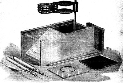
A very nice one is shown in the following picture; it has glass plates to put these small things on, a mirror to reflect the light under them, and all of the little instruments necessary. The price is $2.00, and this covers the entire cost of a nice strong box with a place for each part, which will be sent to any address for this price.
William Beverley Harison, 3 and 5 West 18th St., N.Y. City